 Patrick Farcy1*
 Dominique Durand2
 Guillaume Charria1,3
 Suzanne J. Painting4
 Timo Tamminen5
 Kate Collingridge4
 Antoine J. Grémare6 Laurent Delauney1
 Ingrid Puillat1,3
- 1Institut Français de Recherche pour l’Exploitation de la Mer (IFREMER), Brest, France
- 2Independent Researcher, Bergen, Norway
- 3UMR6523, Laboratoire d’Océanographie Physique et Spatiale (LOPS), Brest, France
- 4Centre for Environment, Fisheries and Aquaculture Science (CEFAS), Weymouth, United Kingdom
- 5SYKE, Helsinki, Finland
- 6Université de Bordeaux, Bordeaux, France
The coastal area is the most productive and dynamic environment of the world ocean, offering significant resources and services for mankind. As exemplified by the UN Sustainable Development Goals, it has a tremendous potential for innovation and growth in blue economy sectors. Due to the inherent complexity of the natural system, the answers to many scientific and societal questions are unknown, and the impacts of the cumulative stresses imposed by anthropogenic pressures (such as pollution) and climate change are difficult to assess and forecast. A major challenge for the scientific community making observations of the coastal marine environment is to integrate observations of Essential Ocean Variables for physical, biogeochemical, and biological processes on appropriate spatial and temporal scales, and in a sustained and scientifically based manner. Coastal observations are important for improving our understanding of the complex biotic and abiotic processes in many fields of research such as ecosystem science, habitat protection, and climate change impacts. They are also important for improving our understanding of the impacts of human activities such as fishing and aquaculture, and underpin risk monitoring and assessment. The observations enable us to better understand ecosystems and the societal consequences of overfishing, disease (particularly shellfish), loss of biodiversity, coastline withdrawal, and ocean acidification, amongst others. The European coastal observing infrastructure JERICO-RI, has gathered and organized key communities embracing new technologies and providing a future strategy, with recommendations on the way forward and on governance. Particularly, the JERICO community acknowledges that the main providers of coastal observations are: (1) research infrastructures, (2) national monitoring programs, and (3) monitoring activities performed by marine industries. The scope of this paper is to present some key elements of our coastal science strategy to build it on long term. It describes how the pan-European JERICO community is building an integrated and innovation-driven coastal research infrastructure for Europe. The RI embraces emerging technologies which will revolutionize the way the ocean is observed. Developments in biotechnology (molecular and optical sensors, omics-based biology) will soon provide direct and online access to chemical and biological variables including in situ quantification of harmful algae and contaminants. Using artificial intelligence (AI), Internet of Things will soon provide operational platforms and autonomous and remotely operated smart sensors. Embracing key technologies, high quality open access data, modeling and satellite observations, it will support sustainable blue growth, warning and forecasting coastal services and healthy marine ecosystem. JERICO-FP7 is the European 7th framework project named JERICO under Grant Agreement No. 262584. JERICO-NEXT is the European Horizon-2020 project under Grant Agreement No. 654410. JERICO-RI is the European coastal observing research infrastructure established and structured through JERICO-FP7 and JERICO-NEXT, and beyond.
Introduction
EU Context and Challenges of Coastal Observation
The coastal and shelf-sea areas are the most productive and dynamic environments of the world ocean offering significant resources and services for mankind. As exemplified by the UN Sustainable Development Goals, these areas have tremendous potential for innovation and growth in blue economy sectors.
Due to the inherent complexity of the natural coastal environment system, the answers to many societal questions are unknown, and the cumulative impacts of multiple stressors, imposed by anthropogenic pressures such as pollution and climate change are difficult to assess and forecast.
To meet these challenges, over the past few decades the European Union (EU) has implemented a number of environmental directives. The main policy drivers for monitoring in European coastal waters are the EU Marine Strategy Framework Directive (MSFD, European Commission, 2008) and the Water Framework Directive (WFD, European Commission, 2000), as well as Regional Seas conventions such as OSPAR and HELCOM (Painting et al., 2019). Requirements of policy drivers are applied at national level and innovative marine observing systems have been implemented in coastal and shelf seas around Europe. Their purpose is primarily to address local/regional monitoring and oceanographic research demands. The heterogeneity in monitoring methods used and the limited spatial coverage of observing systems limit the development of consistent datasets over larger geographical scales. The observations are often driven by short-term research projects, which may affect their consistency over time and their sustainability. A Europe-wide observing infrastructure which integrates individual national components requires major efforts toward harmonization, standardization of methods, and development of common strategies for development and consolidation of the European observing capacity (see Figure 3).
A key challenge for the European coastal marine research community is to increase the consistency and sustainability of dispersed networks and infrastructures by integrating their observations within a shared pan-European framework/infrastructure. Such an infrastructure should develop its own strategy to tackle long term and large-scale issues and interact with local/regional monitoring programs to enhance the overall quality and sustainability of the observations they provide.
Toward a European Coordination of Coastal Observing Systems
Birth of European Coastal Research Community
Initiated in 2010, the JERICO-FP7 project was the first Europe-wide effort toward the harmonization and coordination (Petihakis et al., 2015) of major coastal observing platforms including FerryBoxes, gliders, and fixed platforms (Ostrowski et al., 2016; Baschek et al., 2017; Laakso et al., 2018; Petihakis et al., 2018). (Table 1: exemple of regional infrastructure) Key physical and biogeochemical (e.g., oxygen and pCO2) parameters were considered for harmonization, while emerging technologies such as Sediment Profiler Imagery and time-laps cameras were assessed.
Table 1. List of platforms and sensors currently deployed within the Baltic Ocean Observation System (taken from JERICO-FP7 D1.11 by Morin et al., 2015).
The consortium emphasized that comprehending the complexity of the coastal ocean necessitates a thorough understanding of the coupling between physics, biogeochemistry and biology. This would require new technological developments, to allow fit-for-purpose observations of a larger set of essential coastal variables, supporting the Driver, Pressure, State, Impact, and Response (DPSIR) approach at the ecosystem level. It would also require an a priori definition of the optimal sampling strategy for coupling different kinds of data monitored over very different spatial and temporal scales. The consortium therefore aimed to (1) develop an optimal capacity for assessing the interactions between physics, biogeochemistry and biology, and (2) evaluate emerging technologies within a scientific framework.
In 2015, JERICO-NEXT enlarged the system to include complementary observing systems: coastal radar and a sea floor observatory. The consortium emphasized biogeochemical and biological observations, with the aim to better understand the specific characteristics of the coastal areas. Technological developments under JERICO-FP7 are now operational in some observatories, and new developments are underway for biological observations (e.g., using FlowCam, flow cytometry) and components affecting biogeochemical cycling (e.g., carbon cycle).
JERICO-RI at a Glance: The Mission of JERICO-RI and Its Vision
The mission of JERICO-RI as the “Joint European Research Infrastructure of Coastal Observatories” (Puillat et al., 2016) is to address the challenge of observing the complexity and high variability of coastal areas at a Pan-European level within the context of the EU policy drivers to support excellence in marine coastal research in Europe (Painting et al., 2017).
In the long term, the vision is to provide Europe with a collaborative research infrastructure for coastal science, to maximize the value and impact of the JERICO-RI, and to provide and apply key recommendations for improving the infrastructure, for example in terms of sampling capabilities, representativeness of coastal processes, and support to services and open science.
To achieve this vision, the overarching objective of the consortium is to strengthen and enlarge a solid and transparent European network of coastal observatories and to provide an operational service for the timely, continuous and sustainable delivery of high quality environmental (physical, biogeochemical, and biological) data and services related to the marine environment in European coastal seas (Puillat et al., 2015).
By doing so, JERICO-NEXT helps the research community to provide the best possible quality indicators for the MSFD and to promote joint research initiatives and standardization. It also supports the European industrial sector of coastal instrumentation. From a societal point of view, coastal regions are seen as having the strongest potential for growth and employment. The coastal focus of the JERICO-RI helps to respond to the pressing societal questions, and to engage with key maritime stakeholders.
JERICO-RI currently provides a network of multiplatform coastal observations (Charria et al., 2016; Berta et al., 2018; Heslop et al., 2019), which are being integrated into a System of Systems. Basic elements of the System are nationally funded observing platforms, e.g., FerryBoxes, fixed platforms e.g., moorings, pilings (Kbaier Ben Ismail et al., 2016), underwater gliders (Cotroneo et al., 2019), HF radars (Rubio et al., 2011, 2017; Sciascia et al., 2018), profilers and vessels of opportunity – e.g., fishing-boats (Aydoğdu et al., 2016). Common scientifically sound best practices are adopted, as far as possible, including technologies used, deployment, maintenance, quality control and assessment of data, and delivery to European databases. The JERICO-RI consortium, as the system provider, aims to ensure regular and standardized observations to provide long-term time-series of high-quality multidisciplinary datasets. Its organization and structure are key elements of the roadmap for a sustainable RI.
An Example of National Network as a Token of JERICO-RI
COAST-HF (Coastal OceAn observing SysTem – High Frequency) is a long-term observing network of the physical and biogeochemical high frequency dynamics of the coastal ocean based on 14 moored buoys.
Scientific Objectives
COAST-HF aims understanding and analyzing the evolution of the coastal ecosystem at different temporal scales from extreme or intermittent high frequency (hour, day) events to multi-year trends.
Scientific key questions can then be addressed as:
- The hydrological content from extreme short term events to long term inter-annual evolutions. Considering observations over long time period with a high frequency sampling allows exploring a wide range of temporal scales including the signature of extreme events in the ocean (e.g., low salinity events after strong precipitations) or the long term trends (e.g., Treìguer et al., 2014).
- The sediment dynamics from watersheds to the coastal ocean. Following same temporal scales as for the hydrology, the sediment dynamics is impacted by short term events (e.g., Many et al., 2016), which can change long term evolution of the sediment dynamics.
- The biogeochemical component of coastal ecosystems. For example, the eutrophication processes (e.g., Le Moal et al., 2019) and ocean acidification (e.g., Bozec et al., 2011) are closely linked with physical conditions at different of temporal scales from sub-hourly to inter-annual.
Implemented Network
Since several years (from 2000 for the longest time series in Bay of Brest), the network extends along the Atlantic and Mediterranean French coasts through 14 stations (moored buoys) instrumented for the in situ high-frequency (≤1 h) observations (Figure 1). The common set of parameters continuously measured is including Temperature, Salinity, Turbidity, and Fluorescence. Depending the stations, other parameters from continuous measurements can be provided as the current velocities (from ADCP measurements), primary production (from Fast Repetition Rate Fluorometer), phytoplankton groups (from in situ flow cytometry) and nutrient concentration (from in situ nutrient analyzer).
Figure 1. Fixed stations from the COAST-HF observing network.
Organization and links with other observing infrastructures: Several French research institutes (Ifremer, CNRS, and Marine Universities) are operating those observing systems. This organization in a unique national network for these coastal observing systems aims operating an optimal system to gather efforts and initiatives (e.g., human resources for data management), to converge on best practices, to support common measurement standards, and to provide a unique portal for data access.
Coastal Fixed-Point Observing Systems for the Next Decades
This coastal observing network is contributing to the H2020 JERICO-NEXT project and is part of a French Research Infrastructure ILICO (Cocquempot et al., 2019) dedicated to the nearshore and the coast. COAST-HF is also contributing to the Marine Strategy Framework Directive.
Coastal networks based on fixed stations, as COAST-HF, represent key observing points where new technologies can be easily tested and deployed (e.g., biological sensors, plastics sensors). Those stations are also effective to provide reference observations along the coasts over long-term periods. Collected observations feed research projects but also European or international directives to evaluate the coastal environment health. In the framework of integrated coastal observing systems, those measurements can support data assimilation in coastal numerical models to improve coastal environment forecasts.
This component of the French system is well suited to answer specific national purposes but its integration in a European Research Infrastructure should be collectively discussed with other nations to feed/progress toward a harmonized and integrative EU system of systems based on a common sound scientific strategy, even if national specificities would be considered.
The scope of this paper is to present (next section) some key elements of our coastal science strategy to build it on long term.
Building the Coastal Science Strategy
The JERICO-RI science strategy is based on four key elements. These are summarized here and discussed in detail in the sections below.
The key elements of the coastal science strategy are:
1. A review of environmental threats and gaps in current monitoring programs by EU member states
2. Consideration of specificities of the coastal ocean and consequences
3. Consideration of Essential Ocean and Biodiversity Variables (Inputs from GOOS and GEO BON)
4. Technological constraints and opportunities
The science strategy builds on two documents from the JERICO-FP7 project proposing: (1) an overall future strategy for observations of the European coastal Ocean (D1.11, Morin et al., 2015) and (2) a definition of a strategy for the monitoring of marine biodiversity (D1.9, Wijnhoven, 2014).
Main Environmental Threats in European Coastal Areas and Gaps in Current Monitoring
A literature review and an opinion poll carried out as part of JERICO-NEXT were used to identify the main environmental pressures or threats in European coastal areas. The opinion poll was carried out amongst representatives (e.g., decision-makers, stakeholders, researchers) from the JERICO-NEXT community, and included a section for identifying gaps in monitoring and requirements for improved monitoring of threats and impacts.
Main Environmental Threats in Coastal Monitoring
The majority of respondents in the opinion poll considered the main threats to the coastal environment due to human activity to be marine litter, shipping, contaminants, organic enrichment, and fishing. Pressures identified as having a high potential for causing widespread harm to the environment, but less directly linked with human activity, were regime shift and ocean acidification. The main impacts of human activities on the marine environment were identified to be habitat loss or destruction, underwater noise, and contamination. More than half (50%) of respondents identified other key impacts to be undesirable disturbance (e.g., oxygen depletion), changes in sediment/substrate composition, changes in community composition, harmful micro-organisms and invasive species. The linkages between pressures/threats and their impacts were considered to be complex, due to the cumulative effects of multiple pressures.
Gaps in Current Monitoring
The gap analysis highlighted the need to improve monitoring of environmental pressures or threats in European coastal environment. Two thirds of respondents considered monitoring programs to be partly adequate for addressing environmental threats, while a quarter considered monitoring programs to be inadequate. Most responses indicated inadequacies in the spatial and/or temporal scales at which monitoring takes place, as well as inadequate monitoring of parameters.
Suggestions for improved monitoring programs emphasized the need for improved design, increased monitoring effort (for biogeochemistry and biology), better linkages with research and the use of new technologies. These are given in detail by Painting et al. (2019) and underpin the JERICO-RI future strategy for observations of the European coastal ocean. Although monitoring programs are required to meet the needs of policy end-users, they should also address longer-term scientific objectives, which cut across policy and other drivers and consider cumulative effects of multiple pressures.
Specificities of the Coastal Ocean and Some Associated Consequences
Societal and Policy Needs
In 2015, The JERICO-RI community highlighted that coordinated observations of the European coastal ocean are required for meeting both scientific and societal needs (Crise et al., 2018). Scientific needs are to assess global change, and to unravel the impacts of natural and anthropogenic changes. Societal requirements are tightly linked with the concept of environmental risks, which applies to a large variety of hazards (e.g., physical, chemical, biological) and geographical scales (e.g., from the erosion of a single beach to a whole ecosystem through the concept of ecosystem health). The JERICO-RI community emphasized the importance of meeting policy requirements and, more specifically, those associated with the MSFD and its eleven descriptors as well as Regional Sea conventions such as OSPAR and HELCOM. As a consequence, the JERICO-NEXT project has been organized according to six scientific topics: (i) phytoplankton biodiversity and Harmful Algal Blooms, (ii) benthic biodiversity and habitats, (iii) monitoring of organic pollutants and their impact on biology, (iv) hydrography and transport, (v) carbon cycle and carbonate systems, and (vi) operational oceanography and forecasting. These provide guidelines for implementing harmonization, technological developments, and data management across the RI in nine regional seas around Europe. It also stressed the fact that “the monitoring of coastal seas is complex” and that “the coastal monitoring needs to measure many parameters coming from multiple observing systems.”
Monitoring biological variables: The JERICO-RI community recognized specific challenges in monitoring biological variables, which led to the elaboration of a strategy document dedicated to the monitoring of biodiversity (Wijnhoven, 2014). There was a strong discrepancy between the platforms/sensors approach developed by JERICO-RI and traditional biodiversity assessments (Figure 2). The JERICO-RI community acknowledged that actual standardized measurements of marine biodiversity at various levels over larger temporal and spatial scales are still largely missing. This starting point led to the elaboration of a more comprehensive strategy for the study of marine biodiversity, including the emerging use of omics approaches and image analysis techniques.
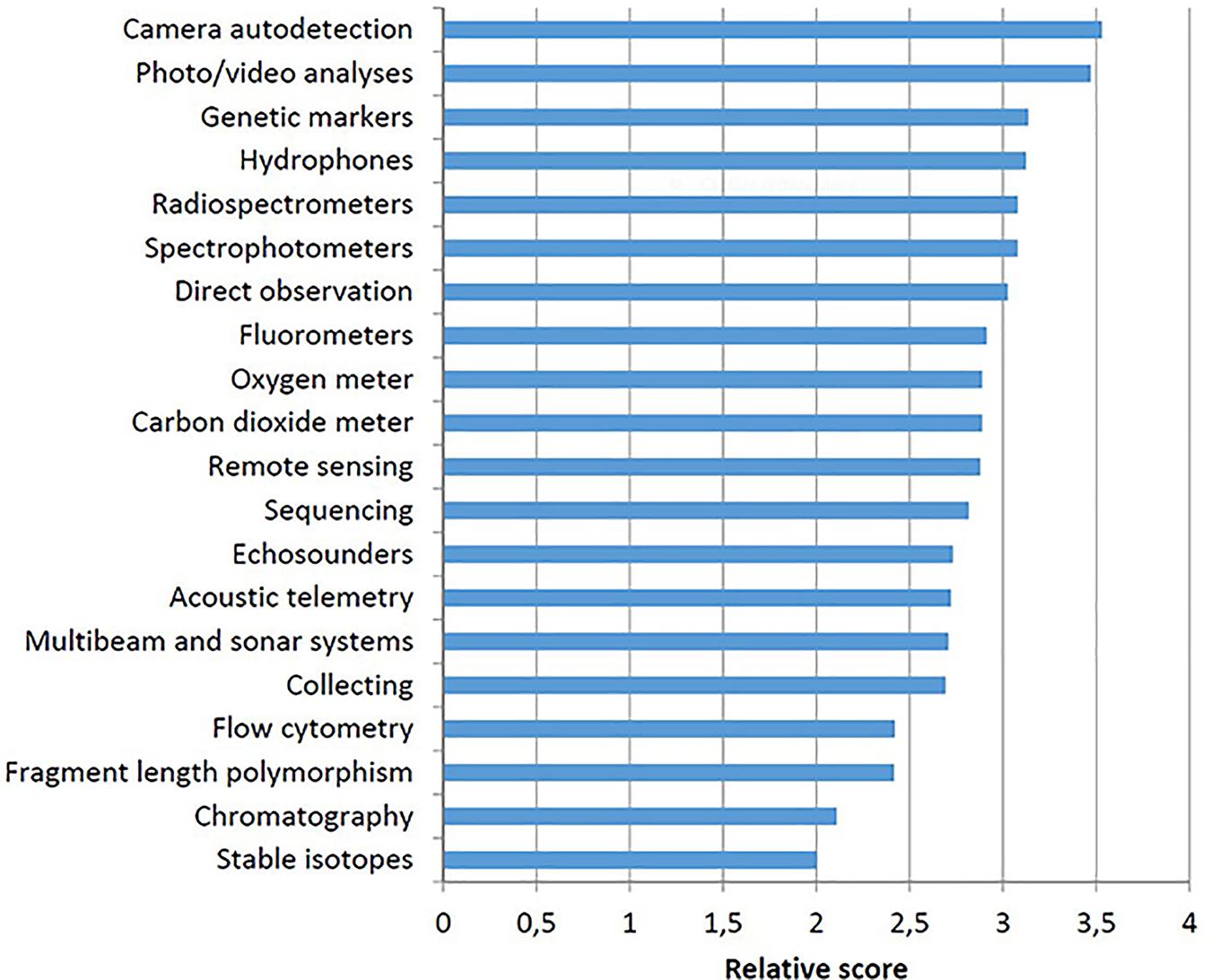
Figure 2. Ranking and relative scores of potential methodologies for assessing biodiversity to be integrated in the JERICO-RI network. Taken from JERICO-FP7 D1.9 by Wijnhoven (2014).
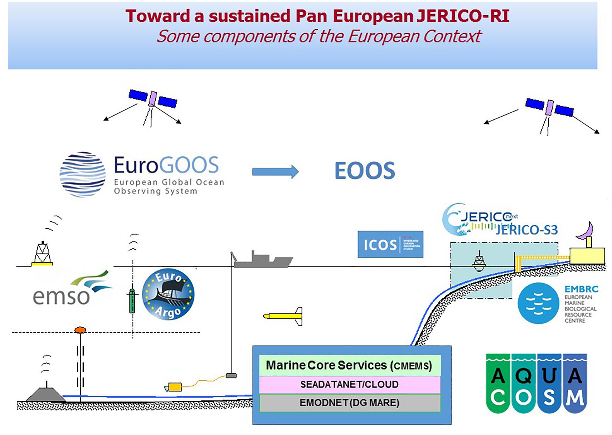
Figure 3. Possible future positioning of JERICO-RI as the coastal component of an emerging European coastal Ocean Observing System.
Dedicated potential new technologies have also been explored as a basis for new sensors based on their scoring against seven criteria including: (1) potential indicator value, (2) possibility of deployments on different platforms, (3) type of delivered data, (4) spatial coverage, (5) operability, (6) cost, and (7) breadth of application spectrum. Results underlined the high potential of optical and passive acoustic methods (Figure 2) for assessing both benthic and pelagic diversity. Some corresponding technologies are currently under developments within JERICO-NEXT (Lefebvre and Poisson-Caillault, 2019).
The JERICO-RI community has developed interactions with other initiatives more specifically dedicated to the monitoring of marine biodiversity, including: European EEA, LTER-Europe, GEO BON, ICES, LifeWatch, and EMBRC. JERICO-RI has stressed the need to harmonize the locations of the observatories and to use its own data for evaluating potential explanatory parameters for monitoring and assessing spatio-temporal changes in biodiversity. For example, JERICO-RI has proposed that monitoring over a large-scale grid using current platforms/sensors be combined with in-depth biodiversity measurements obtained along a number of transects, and using a ratio between realized and potential biodiversity as an indicator of the environmental status in assessment areas.
Modeling and Data Assimilation
It was also highlighted that heterogeneities/dynamics in the coastal ocean are enhanced because land and atmospheric forcing are acting at small scales, both in space and time. This raised the question of how those spatial and temporal heterogeneities/dynamics should be observed. The JERICO-RI community emphasized the importance of modeling in providing continuity between observations and in upscaling and downscaling simulations. It stressed the role of new data acquisition and assimilation in validating and optimizing models.
Integrating regional observations: the need for harmonization: The JERICO-RI community acknowledged the fact that in Europe most of the observations of the coastal ocean are achieved at national or subnational level. Consequently, it stated that most of the efforts associated with a new European strategy should be dedicated to integration, and that integration should be addressed at the level of the European Global Ocean Observing System (EuroGOOS). One major objective of JERICO-RI concerning integration, was to homogenize data quality by harmonizing maintenance and operational designs through calibration (see Petihakis et al., 2014) and operations and maintenance (Petihakis et al., 2012).
Needs of Data Management Procedures
The JERICO-RI community also pinpointed the major importance of sound data management procedures, from acquisition to long-term archiving and open access in defining an operational observing system. For that purpose, JERICO-RI made a clear distinction between real time, near real time and delayed data. Finally, JERICO-RI proposed the creation of a JERICO accreditation label acknowledging a set of criteria ensuring that “some standardization and interoperability, and the quality of data for coastal observatories are set.” These include sustainability, operability and interoperability, and observing purpose.
Sustainability aims to ensure the existence of a minimum time-frame during which the system is operational and observations available. Operability and interoperability aim to check that the system is following the best practices during the whole process linking data acquisition and data management. Observing purpose makes a distinction between observatories monitoring only essential ocean variables (EOVs – see below) and those assessing more comprehensive datasets, supporting the DPSIR approach.
Essential Ocean and Biodiversity Variables: Inputs From GOOS and GEO BON
The concept of Essential Ocean Variables (EOVs) was introduced by GOOS (ref: The global ocean observing system 2030 strategy) to rationalize data collection, facilitate data dissemination and maximize data utilization. Within GOOS, EOVs are identified by expert panels, based on relevance, feasibility and cost-effectiveness. An EOV should both be highly relevant to the understanding of the monitored compartment/process and easy to measure.
The status of an EOV is variable according to its level of readiness. This level is assessed based on three main components, namely: (1) requirement processes, (2) coordination of observational elements, and (3) data management and information products, organized through three macro-levels: (1) “Concept,” (2) “Pilot,” and (3) “Mature.” At present, 31 EOVs have been identified with different levels of readiness. Eleven EOVs are currently related to physics, nine to biogeochemistry and 11 (including two emerging ones) to Biology/Ecosystems. The maturity levels of the EOVs related to Biology/Ecosystems are lower than those of EOVs related to physics and biogeochemistry (Table 2).
Table 2. Currently identified EOVs.
Our own analysis is that such a discrepancy between disciplines mostly results from technical issues (i.e., the possibility of acquiring observations automatically at a high temporal frequency and in a rather synoptic way over large spatial scales). This underlines the necessity of improving the technology involved in biological observation. Moreover, when considering candidate EOVs related to biology and ecosystems, one can consider that they do not necessarily constitute proxies of ecological processes. In this sense, it is interesting to pinpoint that the concept of essential variables has been adapted to biodiversity data by the GEO-BON network, which has recently proposed a list of generic Essential Biodiversity Variables (EBVs). The comparison of the initial list of EOVs and the one of EBVs showed major discrepancies, which mostly resulted from the fact that too much emphasis was initially put on operability for EOVs. The situation has improved recently so that care should now be taken in checking that it will soon be transcribed in terms of maturity for biology and ecosystem EOVs.
The current weakness of the readiness level of biology/ecosystem EOVs is most critical when considering the coastal ocean, which is the most productive area and the one hosting the highest biodiversity in the world ocean. The comparison of the current EOV list with the eleven qualitative descriptors of the MSFD shows that most of these descriptors (D) are only partially covered or even not covered at all by currently considered EOVs (Table 3). D4 (food web) for example is only partly covered because of the lack of mature EOVs regarding key biological processes and compartments. Other descriptors are not covered at all by EOVs. This is the case for D6 (sea-floor integrity), D8 (contaminants), D9 (contaminants in food web), and D10 (marine litter). Adding new items to the list of parameters to be observed is thus needed. These additions should at least include benthic fauna, contaminant concentrations and induced biological effects and marine litter. At present, most of these variables can only be measured using ex situ conventional analytical procedures, which should not preclude their integration in a future monitoring network because of: (1) their ecological importance, and (2) their association with long integration time periods.
Table 3. List of the 11 MSFD qualitative descriptors.
Technological Constraints and Opportunities
As far as ecosystem compartments and processes are concerned, the complexity of coastal monitoring is mainly associated with biology due to the high productivity of coastal waters, the diversity of their landscapes and the scarcity of available sensors/platforms (pH sensor – González-Dávila et al., 2016 – FRRF, flow cytometry, FlowCam, barcoding, … – Figure 2), allowing for the automatic and/or semi-automatic monitoring of biological compartments and processes at various spatial and temporal scales. The JERICO-RI community underlined the necessity of new technological developments. It conducted significant developments in the field of biological observations, which consisted of the development of new image analysis procedures/software for assessing biodiversity (Romagnan et al., 2016; Romero-Ramirez et al., 2016) and/or ecological quality status in both pelagic and benthic ecosystems (see JERICO-FP7 deliverable D10.2 by Gaughan et al., 2015). The JERICO-RI community also emphasized the absolute necessity of: (1) enhancing the wider spread of such developments, and (2) achieving other new ones. Both approaches are presently under implementation within JERICO-NEXT.
Synthesis: Identification of Key Bottlenecks to Be Jointly Addressed
Which Observing Systems?
One challenge faced by JERICO-RI is how to simultaneously address requirements for in-depth environmental information and coverage of large heterogeneous regions.
This requires the multiplatform network to evolve from scattered observational platforms with idiosyncratic profiles and capabilities, to a hierarchical structure. This could be achieved through establishing a limited number of so-called “supersites” with harmonized, extensive observational capabilities for major European coastal sea regimes (potentially: Mediterranean Sea, Atlantic coast, Baltic Sea, Channel, and Northern Seas) and linking to a larger number of “satellite” sites (standard observatories), adding spatial coverage, with specific but less extensive observational capabilities.
The “supersites” would be required to provide:
• Comprehensive and top-level, high-frequency measurements in all required scientific areas (marine physics, biogeochemistry, and biology)
• An integrated, multiplatform strategy for long-term observation, process measurements, and experimentation
• Capability for hosting regular joint campaigns
• Observation R&D, benchmarking, inter-calibration
• Coordinated data management and open access
Standard observatories should provide:
• Continuous measurement of key parameters
• Local and regional collaboration in regular acquisition of multisource coastal data (e.g., monitoring programs)
Three main types of platforms should be considered: flagship platforms, multidisciplinary platforms, and dedicated single parameter platforms.
Flagship platforms would typically provide 1-Dimensional continuous multidisciplinary measurements at an appropriate frequency for allowing for a comprehensive assessment of the ecosystem following the DPSIR (Driver-Pressure-State-Impact-Response) approach. Multidisciplinary platforms such as FerryBoxes, most JERICO-RI fixed platforms and some gliders would measure physical, biogeochemical and biological variables. Dedicated single parameter platforms (e.g., HF radar, Wavebuoys, tide gauge, moored current-meter) would supplement the sampling in space and time and provide parameters that are difficult to measure by the other platforms.
This requires the JERICO-RI to establish interactions with a large set of local/regional observation initiatives that do not necessarily meet the supersite criteria and are thus external to the JERICO-RI per se. Through these interactions JERICO-RI would enhance both the quality and the sustainability of the observations. This could ensure data quality and help local initiatives to get higher and longer-term funding from local authorities/stake holders. In return, data would be integrated with JERICO-RI data flows and benefit from the analyses and services produced by JERICO-RI.
Which Variables?
One of the challenges of the future observation of the European coastal ocean is to respond to the societal needs associated with coastal systems. As a whole, these needs are taken into account in the eleven descriptors of the MSFD. Some of these descriptors are not covered by current EOVs. There is thus a clear need not to limit future observation to EOVs but to define a more inclusive set of Essential Ocean Variables for the coastal areas that we can name coastal EOVs (cEOVs). Besides current candidate EOVs, and based on MSFD descriptors, it is suggested that these additions should at least include contaminants and induced biological effects, some key biogeochemical processes and marine litter.
One of the limitations of the current candidate EOVs list (Table 2) for coastal ocean monitoring is insufficient integration of biological/biogeochemical compartments and processes even though these two items are part of most of the societal challenges in coastal areas. A better threshold between relevance and cost effectiveness in incorporating biological variables as ECVs is yet to be found. In the near future, this issue may be partly solved through technological developments. However, these developments are likely to proceed at different speeds for different compartments/processes. In terms of the eco-systemic approach adopted by the MSFD, the incorporation of new variables should not be restricted to new technological developments. As an example, the IOOS system currently provides products oriented toward biological questions (e.g., tuna fishing in NANOOS), which are derived from the acquisition and modeling of geophysical data.
Which Spatio-Temporal Sampling Design(s)?
A distinction can be made between two types of monitored variables: (1) those which are collected in all subsystems in order to tackle global environmental issues, and (2) those which are specific to a restricted number of subsystems in relation to local/regional issues. The JERICO-RI community is presently addressing: (1) the opportunity of conceiving the future monitoring of the European coastal Ocean as a network of regional systems, (2) the most appropriate delimitations of these regional systems, and (3) the threshold between the specificities of each regional system and the necessity/interest of integrating some observations at the level of the system of systems.
The analysis of current RIs shows that the emphasis is put on the acquisition of automatically and semi-automatically measured data that can be processed and used (e.g., for data assimilation) in near real-time. This is well suited for geophysical data because of the co-existence of automated sensors and efficient models. This approach has worked for the open ocean and in the coastal ocean for some biological/biogeochemical processes (e.g., NANOOS fishing products) and also been linked to societal requirements. It is essential to include biological/biogeochemical variables in future monitoring of the European coastal ocean, raising the issue of how biological data should be harmonized with geophysical data. Two different approaches can be taken. For example, IOOS has launched a specific small-scale project in which the acquisition of biological and geophysical data are coupled. The same approach has been developed within JERICO-NEXT through its six Joint Research Activity Projects, which provide practical experience of developing an appropriate monitoring strategy based on a variety of case studies. Conversely IMOS, through its plankton 2015 project, has produced a purely biological synthesis based on an 8-year sampling period. The JERICO-RI community is presently considering the best way to reconcile these two approaches to get the best possible coordination between biological/biogeochemical and geophysical data acquisition and processing.
How to Harmonize Data Acquisition and Modeling?
In addition to the need to integrate data at the level of the whole system of systems, there is a need to harmonize best practices in marine data acquisition. The JERICO-RI community has made significant advances on this topic, and in establishing a JERICO set of criteria, the JERICO Label. JERICO-RI is presently coordinating with other similar initiatives, such as those led by EMSO-ERIC (European multidisciplinary seafloor and water column observatories), AtlantOS (Cross Atlantic collaboration on ocean observations), ICOS-ERIC (Integrated Carbone observation system). The consortium will carry on its work on the definition and extension of the JERICO Label. Aside from gathering information and procedures on systems deployments, sensor calibration, data management and other harmonization procedures, the consortium aims to share the relevant computing codes and protocols to make them easier to apply in the dedicated virtual environment of JERICO-RI.
The importance of modeling in the processing of observational data and in the delivery of products for end-users is commonly acknowledged. Modeling enables continuity between spatial and temporal observations and high-resolution mapping, which can be used to produce end-products. Up to now this effort has mostly dealt with geophysical models. The development of biological and biogeochemical models could/should also constitute a criterion for the inclusion of new variables in the future monitoring of the European coastal ocean.
Main Technological Breakthrough to Improve Coastal Observations
Coastal observing systems are characterized by their heterogeneity in terms of platforms, sensing systems and methodology used through the whole data acquisition chain. It is challenging to make use of many related technologies that are evolving fast. Through JERICO-FP7 and JERICO-NEXT, much progress has been achieved for observing physical, chemical and biological compartments. One of the JERICO-RI strategic objectives is now to upgrade the Technological Readiness Level (TRL) of the biological observing system to a similar level to that of the physical and chemical systems.
New technologies are emerging from other communities, e.g., biotechnology, information and communication technology (ICT), that can enable drastic improvements in our present capability to observe the complex and highly variable coastal environments. Embracing the most mature and relevant developments may provide a new capacity for optimizing coastal observations (cost-effectiveness) and for coastal warning systems. Furthermore omics-based biotechnologies are already providing ways of observing important variables that could not be observed in situ to date. These include contaminants, phytoplanktonic biodiversity and in situ imaging methods for observing the distribution, abundance, diversity and biomass of phytoplankton and zooplankton, with a high temporal and spatial resolution. JERICO-NEXT is one of the main contributors to the EUROGOOS Technology Plan Working Group (TPWG) and push to create a European Alliance for Marine Technology.
How the Jerico-Ri Science Strategy Impacts the Governance Model: From Integration in Marine Sciences to the Integration of Systems and Technologies
The coastal seas are characterized by complex processes depicting high coupling and feedbacks between physical, chemical, geochemical, and biological compartments/processes in the water column, at the seabed, and between pelagic and benthic compartments. Biogeochemical processes in coastal seas are under pressure from diverse land-based human activities [e.g., through river and point source discharges (e.g., sewage)], atmospheric deposition, and long-distance transport of chemical and biological compounds. Consequently, at the heart of the JERICO-RI strategy is the principle that we cannot understand the complexity of the coastal ocean if we do not understand the coupling between physics, biogeochemistry and biology. Reaching such an understanding requires technological developments allowing for improved monitoring of a larger set of parameters. It also requires an a priori definition of the optimal deployment strategy for coupling diverse datasets monitored over very different spatial and temporal scales. Moreover, the science strategy would need to be agreed and implemented to take account of local/national requirements as well as broader scientific objectives.
Results from the JERICO-RI project strongly emphasize the fact that monitoring of coastal systems and processes at the relevant spatial and temporal scales requires the development of an integrated coastal observation system of systems. Such a system would need to: (1) deliver high frequency in situ measurements of the required physical and/or biogeochemical parameters from the sea-shore to the shelf break using a range of platforms, (2) include lower frequency measurements of key (biological/biogeochemical) parameters that cannot be monitored automatically, and (3) give open access to all the environmental data in accordance with the FAIR principle (Findable, Accessible, Interoperable and Re-usable).
The development of such an integrated system of systems has implications for the way ocean observations in Europe are coordinated, and for the governance model as European contribution to GEOSS. Certainly, the societal needs, economic potential and scientific challenges inherent to the European coastal ocean can only be properly addressed by building a strong, specific and coast-focused observing system of systems, with a dedicated strategy aimed at supporting the sustainable development of European coastal regions. This observing system would provide the coastal component of an emerging European coastal Ocean Observing System (EOOS); the latter possibly providing the ultimate governance structure that would link the different building-blocks of European coastal Ocean observations, being open-ocean RIs (Euro-Argo, EMSO), RIs related to the biological compartment (EMBRC, LifeWatch) and the proposed integrated coastal component.
Conclusion and Perspectives
Coastal regions have a strongest potential for growth and employment in Europe. This brings them to a high priority in nation development. The importance of complex processes and interactions in the coastal ocean, requires investing in observations of physical, chemical and biological parameters and in dedicated technological innovation in key areas of biogeochemical observing technologies.
JERICO-RI as the Joint European Research Infrastructure for Coastal Observatories aims to progress on these goals. In a long-term framework, it provides high quality marine data, expertise and infrastructures for Europe coastal seas. The data are multidisciplinary, standardized, quality controlled, sustained and interoperable, and free to access and use. It brings a joint multidisciplinary effort to establish the Coastal component of a future integrated European Ocean Observing System (EOOS).
In line with GOOS and EOOS initiatives, JERICO-RI can coordinate coastal Ocean Observing components through harmonization of data collection, QA and access, filling technological gaps, linking open ocean change to coastal systems and societal impacts. In Europe, the tool to build such coordinated research infrastructure is the European Strategy Forum on Research Infrastructures (ESFRI).
The overarching target of JERICO-RI is to provide researchers with continuous and more valuable coastal data and datasets, coupling physical and biological information in an operational way, as well as extending the cooperation with Marine Infrastructures in Europe (CMEMS, EuroARGO, EMSO, ICOS, EMBRC) and outside Europe (United States, Canada, Australia, New Zealand, etc.), as well as cooperation with scientific communities, industry and other stakeholders, fostering innovation, and aligning strategy with COPERNICUS, EMODNET, and GEO/GEOSS.
As future steps, in the next 4 years, the ambition is to provide a state-of-the-art, fit-for-purpose and visionary observational research infrastructure, expertise, and high-quality data on European coastal and shelf seas. As a world-class research infrastructure, it provides high-impact innovation. Major user-driven improvements will be realized in terms of observing the complexity of coastal seas and continuous observation of the biology, access to facilities, data and services, best practices and performance indicators, innovative monitoring strategies. As well, cooperation with other RIs, scientific communities, industry and other stakeholders, fostering innovation, and aligning strategy with COPERNICUS, EMODNET, and GEO/GEOSS.
JERICO-RI will extend its expertise toward the shelf seas and the littoral by using satellite and/or modeling data, and still not be restricted to pure technological aspects but will also include fundamental scientific advancement. As an essential step forward, JERICO-RI will drive the preliminary development of an e-infrastructure in support to scientists and users by offering access to dedicated services. It will progress on the design of the RI and its strategy for sustainability.
A strong coastal infrastructure, as masterpiece for the coastal part of EOOS, should help for reaching at least two goals of the GOOS strategy in the framework of SDG14:
1/ Comprehension of the impact of climate change on the coastal areas and extreme events;
2/ Coastal seas and ecosystem health.
Key Elements for a Harmonized Coastal Observation System of Systems in Europe; Recommendations From JERICO-RI
- Many specificities of coastal processes and their complexity requires the development of an integrated coastal observation system of systems that: (1) delivers high frequency in situ collected physical and/or biogeochemical data, from the sea-shore to the shelf break from a range of platforms, complementing each other for addressing the high spatio-temporal variability inherent to coastal regions, (2) also includes the lower frequency collection of key (biological/biogeochemical) parameters that cannot be monitored automatically, and (3) gives open access to all the environmental data in respect of the FAIR principle (Findable, Accessible, Interoperable, and Re-usable).
- It is essential to include biological/biogeochemical variables in a future monitoring of the European coastal ocean.
- Deployments of multiplatform observations are required in a harmonized way, beyond the nation boundaries, to get inter-comparable data on agreed common variables and shared knowledge.
- Observation and monitoring usually answer to various national, regional and local purposes. Thus, two types of variables are to be considered: those to tackle for global environmental issues, those which are specific to a restricted number of subsystems in relation with local/regional issues.
- Coupling of geophysical models with biological (e.g., niche models) and biogeochemical ones becomes a key issue that should also be tackled in a federative way. The development of biological and biogeochemical models could/should also constitute a criterion for the inclusion of new variables in the future monitoring of the European coastal ocean.
- A major challenge is to upgrade the Technological Readiness Level (TRL) of the biological observing system as close as possible to the physical and biogeochemical ones.
Author Contributions
The background of this work was written by SP, DD, AG, and KC (D1.11 in the framework of JERICO-NEXT). The concept of “supersite” was provided by TT. PF and DD wrote the first draft of the manuscript. PF, IP, LD, and DD reviewed the manuscript. SP approved the final version of the manuscript. GC wrote the “COAST-HF” text (section “An Example of National Network As a Token of JERICO-RI”). Information and Figures are Extracted From JERICO-NEXT Deliverables (Available at: http://www.jerico-ri.eu).
Funding
JERICO-NEXT has received funding from the European Commission’s Horizon 2020 Research and Innovation Programme under Grant Agreement No. 654410 and JERICO under Grant Agreement No. 262584 Project coordinator: PF.
Conflict of Interest Statement
DD was employed by COVARTEC.
The remaining authors declare that the research was conducted in the absence of any commercial or financial relationships that could be construed as a potential conflict of interest.
Acknowledgments
The authors would like to thank the JERICO-NEXT consortium membership: PF, IFREMER, Brest, France; DD, COVARTEC AS, Bergen, Norway; GC, IFREMER, Brest, France; SP, CEFAS, Lowestoft, United Kingdom; KC, CEFAS, Lowestoft, United Kingdom; AG, CNRS, University of Bordeaux, Bordeaux, France; IP, IFREMER, Brest, France; LD, IFREMER, Brest, France; TT, YMPARISTO, Helsinki, Finland; Julien Mader, AZTI, Derio, Spain; Anna Rubio, AZTI, Derio, Spain; Simon Keeble, Blue Lobster, Wales, United Kingdom; Veronique Creach, CEFAS, Lowestoft, United Kingdom; Giovanni Coppini, CMCC, Leece, Italy; Stefania Sparnocchia, CNR-ISMAR, Ancona, Italy; Alejandro Orfila, CSIC, Madrid, Spain; Anouk Blauw, DELTARES, Delft, Netherlands; Antonio Novellino, ETT, Genoa, Italy; Glenn Nolan, EuroGOOS, Brussels, Belgium; Dan Angelescu, FLUIDION, Paris, France; Lauri Laakso, FMI, Helsinki, Finland; George Petihakis, HCMR, Anavyssos, Greece; Wilhelm Petersen, HZG, Geesthacht, Germany; Antonio Martinho, Istituito Hidrografico, Lisbon, Portugal; Henning Wehde, IMR, Bergen, Norway; Atanas Palazov, IO-BAS, Varna, Bulgaria; Catherine Boccadoro, NORCE, Bergen, Norway; Dick Schaap, MARIS, Voorburg, Netherlands; Paul Gaughan, Marine Institute, Galway, Ireland; Kai Sorensen, NIVA, Oslo, Norway; Rajesh Nair, OGS, Sgonico, Italy; Machteld Rijkeboer, Rijkswaterstaat, Delft, Netherlands; Nick O’Neill, SLR, Dublin, Ireland; John Breslin, SmartBay, Galway, Ireland; Bengt Karlson, SMHI, Norrköping, Sweden; Joaquín Tintoré, SOCIB, Palma, Spain; Jukka Seppälä, SYKE, Helsinki, Finland; Aldo Drago, University of Malta, Msida, Malta; Joaquin del Rio, UPC Barcelona, Barcelona, Spain; Simon Claus, VLIZ, Ostend, Belgium; Sylvie Pouliquen, EURO ARGO ERIC, Plouzané, France.
References
Aydoğdu, A., Pinardi, N., Pistoia, J., Martinelli, M., Belardinelli, A., and Sparnocchia, S. (2016). Assimilation experiments for the fishery observing system in the Adriatic Sea. J. Mar. Syst. 162, 126–136. doi: 10.1016/j.jmarsys.2016.03.002
Baschek, B., Schroeder, F., Brix, H., Riethmuller, R., Badewien, T. H., Breitbach, G., et al. (2017). The coastal observing system for Northern and Arctic Seas (COSYNA). Ocean Sci. 13, 379–410. doi: 10.5194/os-13-379-2017
Berta, M., Lucio, B., Annalisa, G., Marcello, G. M., Anne, M., Carlo, M., et al. (2018). Wind-induced variability in the Northern Current (northwestern Mediterranean Sea) as depicted by a multi-platform observing system. Ocean Sci. 14, 689–710. doi: 10.5194/os-14-689-2018
Bozec, Y., Merlivat, L., Baudoux, A. C., Beaumont, L., Blain, S., Bucciarelli, E., et al. (2011). Diurnal to inter-annual dynamics of pCO2 recorded by a CARIOCA sensor in a temperate coastal ecosystem (2003–2009). Mar. Chem. 126, 13–26. doi: 10.1016/j.marchem.2011.03.003
Charria, G., Lamouroux, J., and De Mey, P. (2016). Optimizing observational networks combining gliders, moored buoys and FerryBox in the Bay of Biscay and English Channel. J. Mar. Syst. 162, 112–125. doi: 10.1016/j.jmarsys.2016.04.003
Cocquempot, L., Delacourt, C., Paillet, J., Riou, P., Aucan, J., Castelle, B., et al. (2019). Coastal ocean and nearshore observation: a French case study. Front. Mar. Sci. 6:324. doi: 10.3389/fmars.2019.00324
Cotroneo, Y., Aulicino, G., Ruiz, S., Roman, A. S., Tomas, M. T., Pascual, A., et al. (2019). Glider data collected during the Algerian basin circulation unmanned survey. Earth Syst. Sci. Data 11, 147–161. doi: 10.5194/essd-11-147-2019
Crise, A., d’Alcala, M. R., Mariani, P., Petihakis, G., Robidart, J., Iudicone, D., et al. (2018). A conceptual framework for developing the next generation o marine observatories (MOBs) for science and society. Front. Mar. Sci. 5:318. doi: 10.3389/fmars.2018.00318
European Commission (2000). Establishing a framework for community action in the field of water policy. (Water framework Directive), Directive 2000/60/EC of the European Parliament and of the Council. Off. J. Eur. Commun. L327, 1–72.
European Commission (2008). Establishing a framework for community action in the field of marine environmental policy. (Marine Strategy Framework Directive), Directive 2008/56/EC of the European Parliament and of the Council. Off. J. Eur. Commun. L164, 1–22. doi: 10.1016/j.marenvres.2012.03.003
Gaughan, P., Romero Ramirez, A., Grémare, A., Stemmann, L., Duchêne, J. C., Nolan, G., et al. (2015). Development of Set of Software for Image Analysis. Available at: http://www.jerico-ri.eu/previous-project/deliverables/d10-2-development-of-set-of-software-for-image-analysis/
González-Dávila, M., Santana-Casiano, J. M., Petihakis, G., Ntoumas, M., Suárez de Tangil, M., and Krasakopoulou, E. (2016). Seasonal pH variability in the Saronikos Gulf: a year-study using a new photometric pH sensor. J. Mar. Syst. 162, 37–46. doi: 10.1016/j.jmarsys.2016.03.007
Heslop, E., Tintore, J., Rotllan, P., Alvarez-Berastegui, D., Fontera, B., Mourre, B., et al. (2019). SOCIB integrated multi-platform ocean observing and forecasting: from ocean data to sector-focused delivery of products and services. J. Operat. Oceanogr. 1–13. doi: 10.1080/1755876x.2019.1582129
Kbaier Ben Ismail, D., Lazure, P., and Puillat, I. (2016). Statistical properties and time-frequency analysis of temperature, salinity and turbidity measured by the MAREL Carnot station in the coastal waters of Boulogne-sur-Mer (France). J. Mar. Syst. 162, 137–153. doi: 10.1016/j.jmarsys.2016.03.010
Laakso, L., Mikkonen, S., Drebs, A., Karjalainen, A., Pirinen, P., and Alenius, P. (2018). 100 years of atmospheric and marine observations at the Finnish Uto Island in the Baltic Sea. Ocean Sci. 14, 617–632. doi: 10.5194/os-14-617-2018
Le Moal, M., Gascuel-Odoux, C., Ménesguen, A., Souchon, Y., Étrillard, C., Levain, A., et al. (2019). Eutrophication: a new wine in an old bottle? Sci. Total Environ. 651, 1–11. doi: 10.1016/j.scitotenv.2018.09.139
Lefebvre, A., and Poisson-Caillault, E. (2019). High resolution overview of phytoplankton spectral groups and hydrological conditions in the eastern English channel using unsupervised clustering. Mar. Ecol. Prog. Ser. 608, 73–92. doi: 10.3354/meps12781
Many, G., Bourrin, F., Durrieu de Madron, X., Pairaud, I., Gangloff, A., Doxaran, D., et al. (2016). Particle assemblage characterization in the Rhone River ROFI. J. Mar. Syst. 157, 39–51. doi: 10.1016/j.jmarsys.2015.12.010
Morin, P., Krieger, M., Durand, D., Puillat, I., and Farcy, P. (2015). The Joint European Research Infrastructure Network for Coastal Observatories: Achievements and Strategy for the Future. D1.11. Available at: https://archimer.ifremer.fr/doc/00349/46022/
Ostrowski, R., Schönhofer, J., and Szmytkiewicz, P. (2016). South Baltic representative coastal field surveys, including monitoring at the Coastal Research Station in Lubiatowo, Poland. J. Mar. Syst. 162, 89–97. doi: 10.1016/j.jmarsys.2015.10.006
Painting, S., Collingridge, K., Durand, D., Grémare, A., Bernard, G., and Puillat, I. (2017). Review of Monitoring Of Environmental Threats and Pressures in Europe. In JERICO-NEXT Deliverable D1.1. Available at: http://www.jerico-ri.eu/download/jerico-next-deliverables/JERICO-NEXT-Deliverable_1.1_V3.3.pdf
Painting, S. J., Collingridge, K. A., Bernard, G., Gremare, A., Creach, V., Arvanitidis, C., et al. (2019). “Marine monitoring in Europe: is it adequate to address environmental threats and pressures?,” in Submitted to the JERICO-NEXT Special Issue of Ocean Science “Coastal Marine Infrastructure in Support of Monitoring, Science, and Policy Strategies, eds I. Puillat, S. Sparnocchia, L. Delauney, G. Petihakis, W. Petersen, A. Grémare, et al.
Petihakis, G., Haller, M., Petersen, W., Nair, R., Seppälä, J., and Salvetat, F. (2014). Report on Calibration Best Practices, in JERICO-FP7 Deliverable D4.2. Available at: http://www.jerico-ri.eu/download/filebase/jerico_fp7/deliverables/D4_2_Report%20on%20Calibration%20best%20practices_v1-3rev.pdf
Petihakis, G., Perivoliotis, L., Korres, G., Ballas, D., Frangoulis, C., Pagonis, P., et al. (2018). An integrated open-coastal biogeochemistry, ecosystem and biodiversity observatory of the eastern Mediterranean - the Cretan Sea component of the POSEIDON system. Ocean Sci. 14, 1223–1245. doi: 10.5194/os-14-1223-2018
Petihakis, G., Petersen, W., Nair, R., Faimali, M., Pavanello, G., Boukerma, K., et al. (2015). “Harmonization in the Joint European research infrastructure network for coastal observatories -JERICO,” in Proceedings of the OCEANS’15 MTS/IEEE Systems and Observatories, Vol. 2, (Washington, DC), 1–8.
Petihakis, G., Sorensen, K., Hernandez, C., Testor, P., Ntoumas, M., Petersen, W., et al. (2012). Report on Best Practice in Conducting Operations and Maintaining, in JERICO-FP7 Deliverable D4.4. Available at: http://www.jerico-ri.eu/download/filebase/jerico_fp7/deliverables/D4.4_Report%20on%20best%20practices%20in%20conductiong%20operations%20and%20maintaining.pdf
Puillat, I., Farcy, P., Durand, D., Karlson, B., Petihakis, G., Seppälä, J., et al. (2016). Progress in marine science supported by European joint coastal observation systems: the JERICO-RI research infrastructure. J. Mar. Syst. 162, 1–3. doi: 10.1016/j.jmarsys.2016.06.004
Puillat, I., Farcy, P., Durand, D., Petihakis, G., Morin, P., Kriegger, M., et al. (2015). “Strategy for sustainability of the Joint European research infrastructure network for coastal observatories - JERICO,” in Proceedings of the OCEANS’15 MTS/IEEE Washington Proceedings. Systems and Observatories, (Washington, DC), 1–8.
Romagnan, J. B., Aldamman, L., Gasparini, S., Nival, P., Aubert, A., Jamet, J. L., et al. (2016). High frequency mesozooplankton monitoring: can imaging systems and automated sample analysis help us describe and interpret changes in zooplankton community composition and size structure — an example from a coastal site. J. Mar. Syst. 162, 18–28. doi: 10.1016/j.jmarsys.2016.03.013
Romero-Ramirez, A., Grémare, A., Bernard, G., Pascal, L., Maire, O., and Duchêne, J. C. (2016). Development and validation of a video analysis software for marine benthic applications. J. Mar. Syst. 162, 4–17. doi: 10.1016/j.jmarsys.2016.03.003
Rubio, A., Julien, M., Lorenzo, C., Carlo, M., Annalisa, G., Antonio, N., et al. (2017). HF radar activity in European Coastal Seas: next steps toward a Pan-European HF radar. Front. Mar. Sci. 4:8. doi: 10.3389/fmars.2017.000008
Rubio, A., Reverdin, G., Fontán, A., González, M., and Mader, J. (2011). Mapping near-inertial variability in the SE Bay of Biscay from HF radar data and two offshore moored buoys. Geophys. Res. Lett. 38:L19607.
Sciascia, R., Berta, M., Carlson, D. F., Griffa, A., Panfili, M., Mesa, M. L., et al. (2018). Linking sardine recruitment in coastal areas to ocean currents using surface drifters and HF radar: a case study in the Gulf of Manfredonia S, Adriatic ea. Ocean Sci. 14, 1461–1482. doi: 10.5194/os-14-1461-2018
Treìguer, P., Goberville, E., Barrier, N., L’Helguen, S., Morin, P., Bozec, Y., et al. (2014). Large and local-scale influences on physical and chemical characteristics of coastal waters of Western Europe during winter. J. Mar. Syst. 139, 79–90. doi: 10.1016/j.jmarsys.2014.05.019
Wijnhoven, S. (2014). Definition Strategy and Interfaces with the Monitoring of Biodiversity, In JERICO-FP7 Deliverable D1.9. Available at: http://www.jerico-ri.eu/previous-project/deliverables/d1-9-definition-strategy-and-interfaces-with-the-monitoring-of-marine-biodiversity/
Keywords: European Research Infrastructure, JERICO and JERICO-NEXT, coastal essential ocean variables, coastal observatories, high frequency, physics, biogeochemistry and biology
Citation: Farcy P, Durand D, Charria G, Painting SJ, Tamminen T, Collingridge K, Grémare AJ, Delauney L and Puillat I (2019) Toward a European Coastal Observing Network to Provide Better Answers to Science and to Societal Challenges; The JERICO Research Infrastructure. Front. Mar. Sci. 6:529. doi: 10.3389/fmars.2019.00529
Received: 28 March 2019; Accepted: 13 August 2019;
Published: 20 September 2019.
Edited by:
John Siddorn, Met Office, United KingdomReviewed by:
Molly McCammon, Alaska Ocean Observing System, United StatesRichrd Kelvin Dewey, Ocean Networks Canada, Canada
Melissa M. Iwamoto, University of Hawai‘i at Mānoa, United States
Copyright © 2019 Farcy, Durand, Charria, Painting, Tamminen, Collingridge, Grémare, and Puillat. This is an open-access article distributed under the terms of the Creative Commons Attribution License (CC BY). The use, distribution or reproduction in other forums is permitted, provided the original author(s) and the copyright owner(s) are credited and that the original publication in this journal is cited, in accordance with accepted academic practice. No use, distribution or reproduction is permitted which does not comply with these terms.
*Correspondence: Patrick Farcy, cGF0cmljay5mYXJjeUBpZnJlbWVyLmZy