 Peter Charles Mackelworth1,2*
 Yael Teff Seker3
 Tomás Vega Fernández4
 Márcia Marques5
 Fátima Lopes Alves5
 Giovanni D’Anna6
 Darren A. Fa7
 David Goldborough8
 Zacharoula Kyriazi9,10
 Cristina Pita5
 Michelle E. Portman3
 Bob Rumes11
 Stephen J. Warr7
 Draško Holcer1,12
- 1Blue World Institute of Marine Research and Conservation, Veli Lošinj, Croatia
- 2Institute for Tourism, Zagreb, Croatia
- 3Faculty of Architecture and Town Planning, Technion – Israel Institute of Technology, Kiryiat Ha Technion, Haifa, Israel
- 4Stazione Zoologica Anton Dohrn, Naples, Italy
- 5Department of Environment and Planning and Centre for Environmental and Marine Studies, University of Aveiro, Aveiro, Portugal
- 6CNR-IAS, Castellammare del Golfo, Italy
- 7Institute of Life and Earth Sciences, University of Gibraltar, Gibraltar, United Kingdom
- 8Van Hall Larenstein, University of Applied Sciences, Leeuwarden, Netherlands
- 9Faculty of Law, Department of Public International Law, Maritime Institute, Ghent University, Ghent, Belgium
- 10Hellenic Center for Marine Research, Institute of Marine Biological Resources and Inland Waters, Argyroupoli, Greece
- 11Royal Belgian Institute of Natural Sciences, Brussels, Belgium
- 12Department of Zoology, Croatian Natural History Museum, Zagreb, Croatia
Transboundary conservation has an important, yet often undervalued, role in the international conservation regime. When applied to the legally ambiguous and interconnected marine environment this is magnified. The lack of clear guidance for transboundary marine conservation from the international conservation community exacerbates this problem, leaving individual initiatives to develop their own governance arrangements. Yet, well-managed transboundary marine protected areas (MPAs) have the potential to contribute significantly to global conservation aims. Conversely, in a period where there is increasing interest in marine resources and space from all sectors, the designation of MPAs can create or amplify a regional conflict. In some instances, states have used MPAs to extend rights over disputed marine resources, restrict the freedom of others and establish sovereignty over maritime space. Six case studies were taken from Europe, North Africa and the Middle East to illustrate how states have interpreted and utilized different legislative mechanisms to either come together or diverge over the governance of marine resources or maritime space. Each of the case studies illustrates how different actors have used the same legislative tools, but with different interpretations and applications, to justify their claims. It is clear that the role of science combined with a deeper engagement with stakeholders can play a critical role in tempering conflict between states. Where states are willing to cooperate, the absence of clear guidelines at the global level means that often ad hoc measures are put into place, with the international frameworks then playing catch up. Balancing different jurisdictional claims with the conservation of the marine environment, whilst considering the increasing special economic interests will become increasingly difficult. Developing a transboundary conservation tool, such as the simple conservation caveats found in the Barcelona Convention and Antarctic Convention, which allow for the establishment of intergovernmental cooperation without prejudicing any outstanding jurisdictional issue, would provide a framework for the development of individual transboundary MPAs.
Introduction
The push to incorporate ecological, climate and biodiversity objectives into mainstream policies means that conservation comes in many forms, facilitated by many different mechanisms. Biodiversity conservation is often referred to in trade, farming, fishery, and other broader environmental agreements, among others (Mackelworth et al., 2018). The use of mainstream policies to promote biodiversity conservation has been mirrored by the use of biodiversity conservation policy to promote other objectives (McClanahan, 2004). For instance, protected areas (PAs), and other effective area based conservation measures (OECMs) (see Supplementary Material for a full glossary of technical terms), are not only being used for biological diversity conservation objectives, but also promoted as solutions to alleviate poverty, counteract the negative effects of globalization and even promote democratic rights (MacKinnon et al., 2015; Diz et al., 2018). Thus, while PAs are widely considered to be the cornerstone of international biological conservation strategy (Dudley et al., 2010), there is increasing recognition for the need to situate them within the broader international planning framework (Margules and Pressey, 2000; Kirkman and Mackelworth, 2016; Fortuna et al., 2018). This is especially important in marine systems where greater connectivity links ecosystems more intensely across political and administrative boundaries (Popova et al., 2019).
The International Union for the Conservation of Nature (IUCN) estimates that approximately 30% of high biodiversity terrestrial sites straddle national borders (Vasilijević et al., 2015). Thus, in order to be successful, transboundary conservation initiatives require the cooperation and coordination of the states involved. In theory, combining conservation aims with political goals should be beneficial for many different stakeholders, including conservationists and politicians (Hammill and Besançon, 2007). Transboundary PAs can be used to improve relationships between bordering states, enhance regional stability, resolve conflict, and peace-build (Ali, 2007; Mackelworth, 2016; Portman and Teff-Seker, 2016). Developed correctly, transboundary conservation can be used as a tool to build consensus between states, bringing them together rather than forcing them apart (Carius et al., 2003). Recently, the IUCN acknowledged the importance of combining conservation with promoting cooperation between states through the special designation of a “peace parks paradigm” typology:
“A Park for Peace is a special designation that may be applied to any of the three types of Transboundary Conservation Areas, and is dedicated to the promotion, celebration and/or commemoration of peace and cooperation” (Vasilijević et al., 2015, p. 1).
The IUCN, as the leading global conservation organization, has provided somewhat confusing guidance for marine transboundary conservation. Despite promoting the IUCN PA categorizations as equally applicable to both marine and terrestrial areas, their latest publication on transboundary conservation expressly states that:
“These guidelines do not offer specific advice about transboundary conservation in the marine realm, which requires separate treatment” (Vasilijević et al., 2015, p. 3).
This guidance has not been forthcoming, yet, in 1998, the former IUCN General Director suggested that the dynamics of the ecological processes and the legal ambiguity of the marine environment may lend itself to the concept of peace parks more readily than on the land (McDowell, 1998).
While cooperation between states can result in gains for both politicians and the environment, the issue of sovereignty often remains a political obstacle. This is especially the case where the relationship between the states is already tense. To mitigate this, the development of tools that facilitate cooperation and recognize, but do not affect, outstanding jurisdictional claims, could remove the need for political posturing (Jay et al., 2016). A legal precedent was set with the development of the Antarctic Treaty in 1959, in which the forward-thinking authors recognized the need for such a tool, in the form of a conservation caveat. This enabled the diverse parties to come together and reach an agreement. Later, the authors of the Protocol concerning Specially Protected Areas and Biological Diversity (SPA/BD Protocol), of the Convention for the Protection of the Mediterranean Sea against Pollution (the Barcelona Convention, 1976 amended 1995), recognized the potential to apply similar conservation caveats to the Mediterranean Sea (see Box 1).
BOX 1. Protocol concerning specially protected areas and biological diversity in the Mediterranean (1995).
Article 2:
2. Nothing in this Protocol nor any act adopted on the basis of this Protocol shall prejudice the rights, the present and future claims or legal views of any State relating to the law of the sea, in particular, the nature and the extent of marine areas, the delimitation of marine areas between States with opposite or adjacent coasts, freedom of navigation on the high seas, the right and the modalities of passage through straits used for international navigation and the right of innocent passage in territorial seas, as well as the nature and extent of the jurisdiction of the coastal State, the flag State and the port State.
3. No act or activity undertaken on the basis of this Protocol shall constitute grounds for claiming, contending or disputing any claim to national sovereignty or jurisdiction.
The concept behind the SPA/BD Protocol caveats is relatively simple. The establishment of intergovernmental cooperation does not prejudice any outstanding legal or political issues regarding the determination of state jurisdiction. Equally, the existence of any such legal or political questions should neither jeopardize nor delay the adoption of measures necessary for the establishment of SPAs in the Mediterranean Sea (Shine and Scovazzi, 2007). The SPA/BD protocol reinforces the international legal precedent set by the Antarctic Treaty for marine transboundary conservation initiatives in all maritime regions, not only the Mediterranean Sea.
While marine conservation initiatives can provide opportunities for transboundary environmental cooperation and peacebuilding efforts (Carius et al., 2003; Mackelworth, 2012), they can also be used to extend political influence, restrict freedoms or even establish sovereignty over a disputed region. The establishment of sovereignty may not be the only “hidden incentive” of states involved in transboundary conservation initiatives. It may also be the intention of one or more states to establish or maintain other nationally prioritized sectoral uses of the sea, under the guise of marine conservation. This may be possible when national conservation objectives are served by cooperation in the transboundary area. In a period where there is increasing interest in marine resources and maritime space the imposition of the jurisdiction of one state actor over another resonates with the concept of ocean grabbing (Franco et al., 2014; Bennett et al., 2015). Ocean grabbing has generally focused on the policies or initiatives that deprive local communities from traditional resources through reallocations by governments and the private sector (Bennett et al., 2015). However, it is a process of legitimation driven by the imbalance of power between the parties involved and the geographic proximity, or adjacency, to the areas being controlled (Foley and Mather, 2018).
Hence, transboundary conservation initiatives have the potential to bring states together or drive them apart. Therefore it is important to distinguish the detrimental initiatives from those employing effective governance processes (Bennett et al., 2015). This study focuses on the role of marine protected areas (MPAs) and OECMs in seizing portions of marine space that have been shared or disputed between neighboring states, the resulting implications for geopolitics and marine conservation, and the potential role of conservation caveats.
Case Studies
Rosh Hanikra Marine Protected Area
Background and Features
Although established several decades ago, Israel’s existing coastal reserves extend only a few 100 m from the shore. In 2012, six new marine reserves that cover a significant portion of the Israeli Mediterranean territorial waters were proposed (Israel Nature Parks Authority [INPA], 2012). In 2014, the Rosh Hanikra MPA was the first to have a significant extension of a small, close-to-shore reserve that has existed since the 1960s (Sas et al., 2010). Official approval from the state was provided in 2016 (Gilad, 2016), however additional approval is required from other relevant ministries for it to become a designated nature reserve (Engert, personal communication). The proposed MPA covers approximately 100 km2, stretching 5 km along the northernmost part of the Israeli Mediterranean Sea, extending to 1,000 m depth, and offshore to an extent of 15 km (Portman et al., 2016).
Political and Strategic Considerations
The northern limit of the proposed MPA is adjacent to an Israeli military exercise zone as well as the disputed Lebanon-Israel maritime border (see Figure 1). The two countries disagree over a contested area of approximately 850 km2, adjacent to the MPA, which is assumed to be rich in natural gas (Ravid, 2011). In the 2010 agreement on the Exclusive Economic Zone (EEZ) with Cyprus, Israel claims this contested area. However, Lebanon states that, as it was not party to this agreement it does not recognize the Israeli delineation of the maritime border. In turn, Israel has objected to the exploration for oil and gas in the contested region by international companies, under Lebanese license (Ayat, 2015). As Israel is not a signatory to (and has not ratified) the United Nations Conventions of the Law of the Sea (UNCLOS), it has refused to use any of the available conflict resolution tools. Mediation efforts by the UN, the US, France and Cyprus have failed to resolve the dispute (Ayat, 2015).
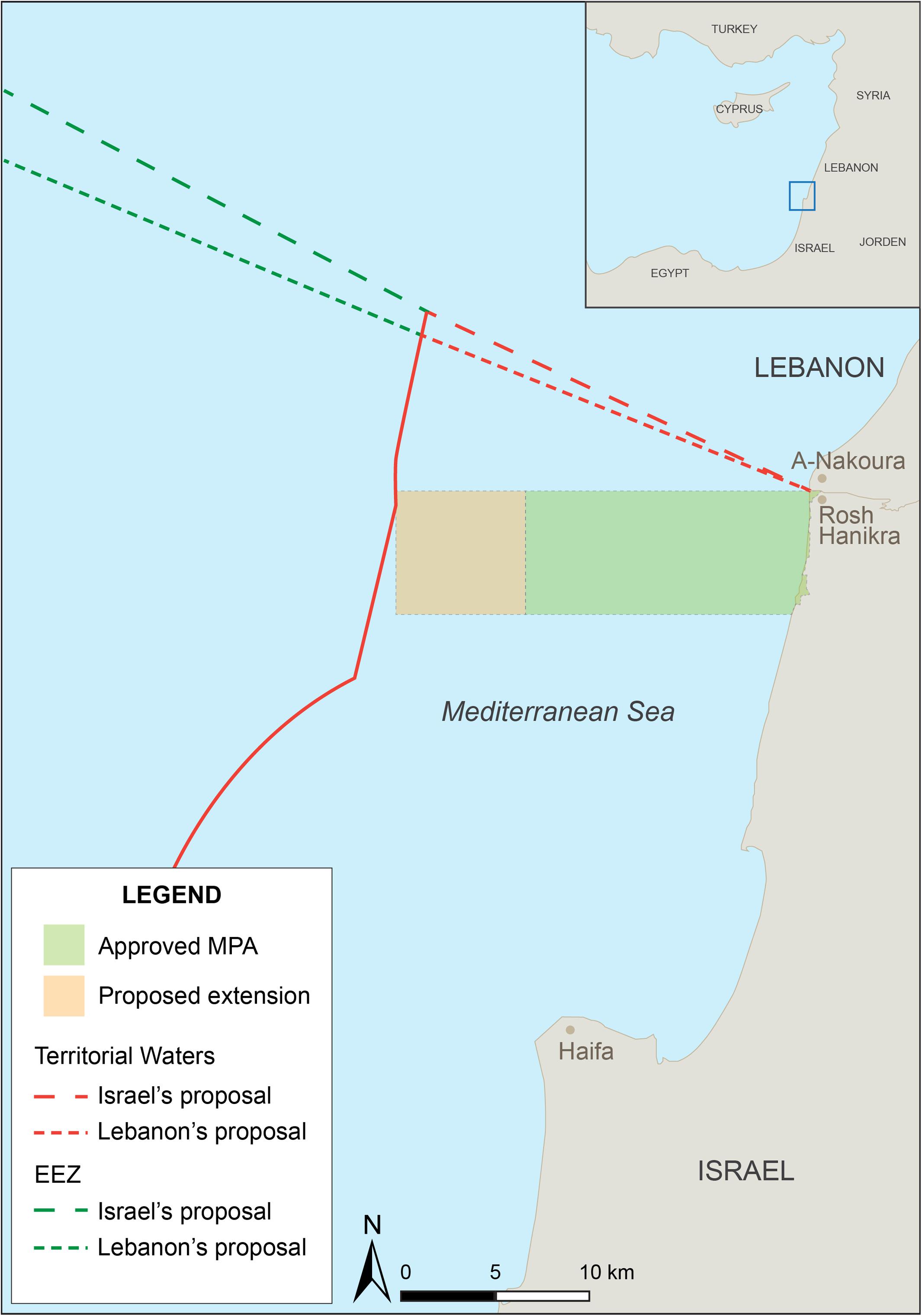
Figure 1. Israel Lebanon.
Lebanon has pushed for the resumption of US efforts to mediate, stating that any extraction of gas by Israel in the contested area would be considered an act of war (Groisman, 2016). To date, Israel has refrained from drilling in the contested area and a map of newly licensed areas for gas exploration excludes this particular area (Ministry of National Infrastructure, Energy and Water Resources (MNIEWR, 2016). In early 2017, Lebanon published a tender for drilling companies to explore the area on its behalf. Likewise, the Israeli government stated its intention to approve a new Marine Areas Act, in which the disputed area is defined as part of their EEZ. Both countries claim that the actions by the other should be considered as an act of aggression (Ben-David, 2017). It seems that neither Israel nor Lebanon will step down from their claims. It should be noted, however, that this dispute has exhibited a different dynamic to that of the terrestrial border. Unlike the maritime border, the terrestrial Israel-Lebanon border has been settled since 2000. Despite this, there have been numerous armed conflicts between the two parties (Eiran, 2017; Teff-Seker et al., 2018). Conversely, at sea, there has not been any violent measures taken by either side.
According to the INPA (Engert, personal communication), the Rosh Hanikra MPA, as submitted to the Israeli planning administration, does not include the contested area. The INPA decided to promote this MPA first, out of the six large MPAs, because they assessed that it would receive the least amount of objection on the part of fishers. This decision was vindicated in committee hearings where representatives from the Ministry of Agriculture did not object to the Rosh Hanikra MPA. While some illegal artisanal fishing activity still occurs, fishers generally tend to avoid the region due to its proximity to the Lebanese border, the restricted Israeli military zone and the fact that the new MPA is based on an existing, smaller reserve, where fishing was already banned up to 3 km from the shoreline.
Lebanon currently has two MPAs: the Palm Islands Nature Reserve in North Lebanon and the Tyre Coast Nature Reserve in South Lebanon. In 2010–2012, the IUCN cofunded and implemented a project that was intended to support the development and declaration of additional MPAs (IUCN, 2012). This effort yielded a list of 18 small sites along Lebanon’s coast, with one, Nakoura, less than 10 km north of Rosh Hanikra (IUCN, 2012). Along with the more northern Ras El Chekaa, the Nakoura MPA was chosen to be considered first for declared MPA status by the Lebanese Ministry of the Environment, UNEP and the GEF (Global Environmental Facility), owing to their high ecological significance and threats related to fishing, pollution and industry runoff (IUCN, 2012, 2014).
Lessons and Synergies
Several synergies are related to the strategic location of the MPA. It creates a de facto “buffer zone” near the border, and enables Israel to further limit access to the area, providing an additional layer of security. In turn, by keeping the area clear of unauthorized intruders should mean more protection for the MPA. Additionally, the proximity to a closed military area is not necessarily negative for the MPA. In Israel, the link between nature reserves and military training areas is common (Weil and Levin, 2015). It is difficult to say whether this was an additional incentive for the government to approve this MPA, and there is no official statement to support this notion. The peripheral location of the MPA, in comparison to the other proposed MPAs, could be another factor facilitating its establishment (Portman and Teff-Seker, 2017). Lastly, the fact that countries wish to establish MPAs near the border, but with separate management, is an example of unilateral planning for cross-border environments. This has resulted from the intractable conflict between the states. However, if tensions decrease, this two-sided MPA regime might yield fruitful marine environmental cooperation.
Mammellone Bank
Background and Features
The “Mammellone” Bank is located in the Strait of Sicily, at 12 nautical miles South-West of the Italian island of Lampedusa and East of the Tunisian island of Kerkennah (Figure 2). It is delimited by the external border of Tunisian territorial sea; the interception of the parallel of Cape Ras Kafoudia and the isobath of 50 m; the border then follows the isobath until its interception with the line projected from Cape Ras Agadir toward North-East (Scovazzi, 1999).
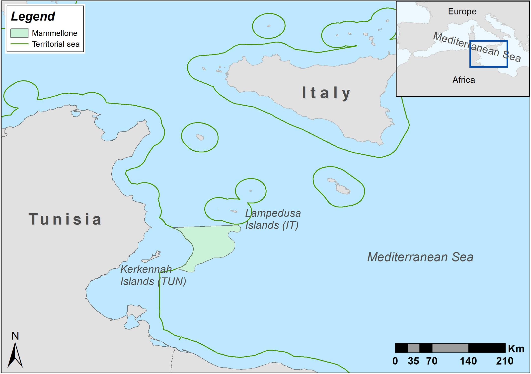
Figure 2. Mammellone Bank.
Political and Strategic Considerations
Since 1973, Tunisia has claimed sovereignty over the Mammellone Bank and considers it to be an exclusive fishing ground (European Union (EU) parliamentary question E-006697-17 of 26 October 2017). The claim is based on the decree of the Constitutional Monarchy of Tunisia from 1951, which states that only vessels with either French or Tunisian flags can operate in the area (Salamone, 2004; Caffio, 2016, p. 101). After declaring independence in 1953, the Tunisian authorities excluded French vessels (Law 63-49 of 30 December 1963) and extended their sovereignty over the Gulf of Tunis, including the Mammellone Bank. Finally, in 1973 Law 73-49 specifies that only Tunisian vessels are authorized to operate in the area (Salamone, 2004).
There have been several bilateral agreements on fisheries in the area between Italy and Tunisia in 1963, 1971 and 1976. The last agreement established an area where only Tunisian fishing vessels could operate, with the possibility for Italian vessels to fish in other areas under certain conditions, as defined by the Tunisian authorities. The exclusive right to patrol was designated to the Tunisian authorities, placing conditions on the Italian government to partially fund the development of the Tunisian fishery. The 1976 agreement was not renewed due to the accession of Italy to the treaty of the European Economic Community (EEC) in 1979, which ceded the exclusive rights to negotiate bilateral fisheries agreements to the Commission (Annex VI of the Aja Declaration, 1976). Disagreement over the terms of the extension of preferential access to Italian fishing vessels, above that of other EU fishing fleets, in Tunisian areas was a contributing factor to the lack of renewal of the agreement (Gutiérrez Castillo, 2008).
While Tunisia and Italy are both signatories to the United Nations Convention on the Law of the Sea (UNCLOS) of 1982, they did not ratify it until 1985 and 1995, respectively. Despite this, in 1979 Italy established a “fish-stocks rebuilding area in the high sea” invoking Article 3 of the Convention on Fishing and Conservation of the Living Resources of the High Seas (CFCLRHS) of 1958 (Ministerial Decree of September 25, 1979). This was later countered by Tunisia who declared the Mammellone Bank a Fishing Exclusive Zone (Law 26 June 2005, No. 50), in apparent agreement with Article 6.2 of the CFCLRHS. This provides the right of any coastal state to take measures to regulate stocks in areas of the high seas contiguous to its own territorial waters. Soon afterward, Italy unilaterally declared the same zone as an Ecological Protection Zone (EPZ), a de facto fisheries restricted area (FRA) (sensu Auster and Shackell, 1997) or a MPA (sensu FAO, 2011) for rebuilding fish stocks beyond the territorial sea (Law 8 February 2006, No. 61) interpreting the provisions contained in the UNCLOS, Article 117 (amended 1994). As yet, however, the EPZs defined by the Italian law 2006/61 has not entered in force (Suárez de Vivero et al., 2010).
Since the establishment of the fishery reserve in 1979 by Italy, Italian warships have attempted to enforce the fishing ban for Italian ships (Law of 14 July 1965, No. 963, abrogated and substituted by Law Decree of 9 September 2012, No. 4). In an attempt to enhance surveillance and ameliorate the conflict, both countries tried joint monitoring which has had little success to date. At the end of 1998, Italy and Tunisia signed an agreement of collaboration to enhance patrolling at sea. However, the implementation of the agreement seems again to be minimal. During the whole period, the Italian trawl-fishers from Mazara del Vallo maintain that the Mammellone Bank was a traditional fishing ground located in the high seas, and continued working there both legally and illegally, the lapse of the 1976 bilateral agreement in 1979.
Lessons and Synergies
During the last two decades, there has been a period of stagnation in the negotiations between Italy and Tunisia, apart from those triggered by the seizures of Sicilian ships fishing illegally in the Mammellone region by the Tunisian authorities, (Question E-006697-17 to the European Commission). Mammellone Bank case study is an example of “mismatching” of the legislative tools and the absence of a shared vision and management of the bank resources. Economics and conservation have failed to reach a sustainable equilibrium mainly due to the lack of effective governance of the bilateral agreement.
However, in 2006, a group of stakeholders including research institutions, fishing enterprises and food processing companies founded the Fishery Production District (FPD), with the support of the local government of Sicily. A branch of the FPD is based in Mazara del Vallo, which also hosts the Italian trawl-fishing fleet that traditionally operated in the Mammellone Bank. The FPD has become very active organizing meetings with representatives of both the Italian and Tunisian authorities in an attempt to foster collaboration in resource management and fisheries. Among other objectives, the FPD aims to promote fishing heritage, obtain a certified quality label for local fish products, and foster innovation and technology transfer (https://www.distrettopescaecrescitablu.it/ accessed November 13, 2018). Recently, lower catches have been recorded in the area, making fishing in the Mammellone less attractive to the Sicilian fleet. The suspicion is that fishing vessels from Libya and Egypt, which face lower fuel and crew costs, are depleting the target species in the area. This appears to have prompted a tighter collaboration between Italy and Tunisia, with the Sicilian FPD emerging as facilitator in the process. The option to protect the area, as originally conceived in the Tunisian law and recently in the Italian designation of the zone, appears particularly appealing now.
The Southern Waters of Gibraltar
Background and Features
In 2004, the Government of Gibraltar proposed the Southern Waters of Gibraltar (UKGIB0002) as a Site of Community Importance (SCI) under the European Council Directive on the conservation of natural habitats and of wild fauna and flora (Habitats Directive, 92/43/EEC) and the Directive on the conservation of wild birds (Birds Directive, 79/409/EEC amended 2009/147/EC) as part of their commitments to the EU Natura 2000 network (see Figure 3). Subsequently in July 2006, the SCI was approved, and the Government of Gibraltar later declared the Southern Waters of Gibraltar as a dual Special Area of Conservation (SAC) and Special Protected Area (SPA) in line with the requirements of the EU Habitats Directive and the Birds Directive, respectively. Both of these directives have been transposed into Gibraltar law since 1995 and the area has been protected as part of the British Gibraltar Territorial Waters (BGTW) since 1991 through Gibraltar’s Nature Protection Act. A management plan, the Southern Waters of Gibraltar Management Scheme (2012), was implemented and has since been updated to include the extent of BGTW in order to help regulate activities and safeguard the protection of species and habitats listed under the aforementioned Directives. In 2014, the whole extent of BGTW were designated as a Marine Nature Area in Gibraltar law.
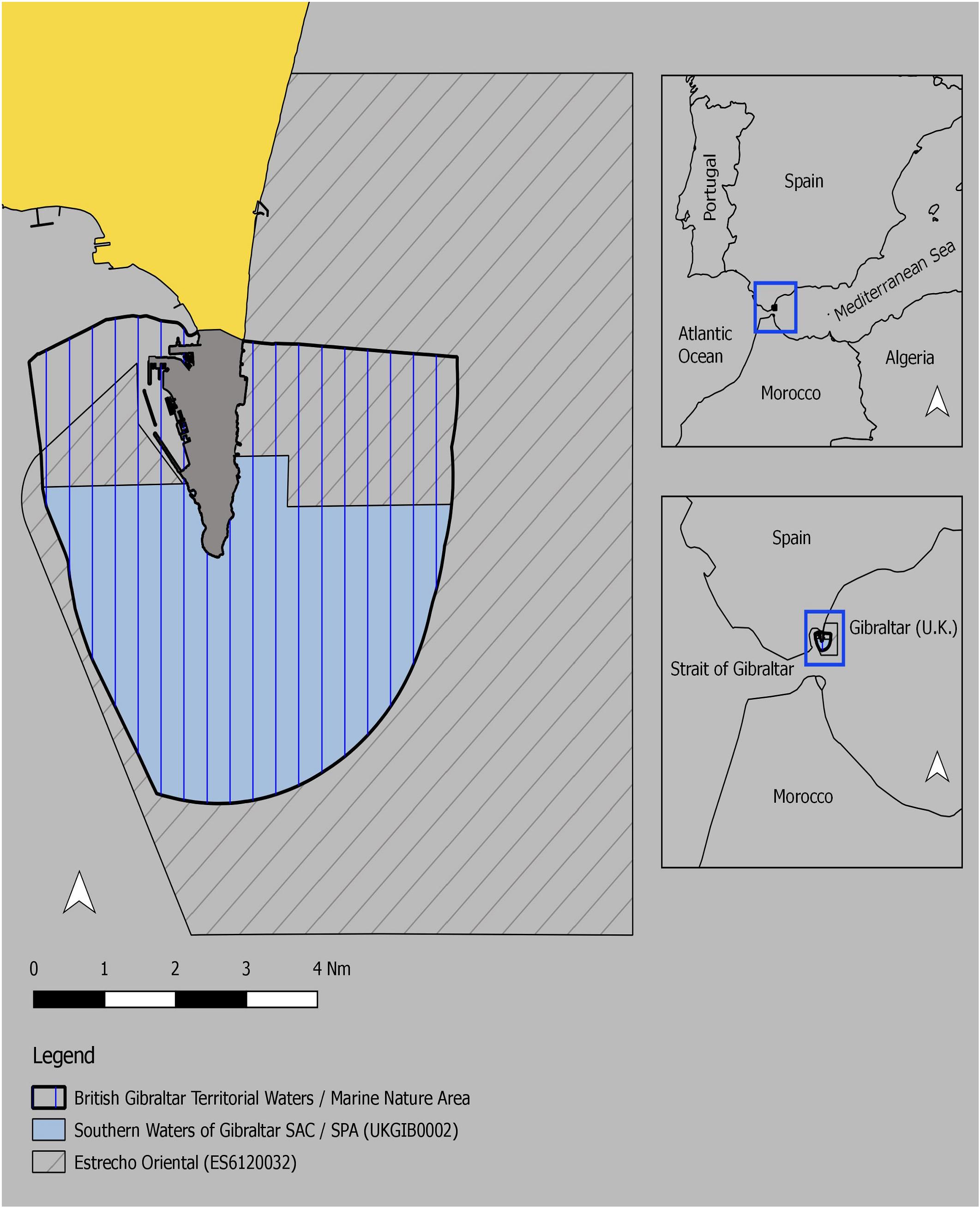
Figure 3. The southern waters of Gibraltar.
Political and Strategic Considerations
In line with Part II, Section 2, Article 3 on the limits of the territorial sea under UNCLOS, ratified by both the United Kingdom and Spain, the territorial waters around Gibraltar extend to three nautical miles to the South and East and up to the median line in the Bay of Gibraltar to the West. Conversely, and despite being a party to UNCLOS, Spain claims maritime rights to all areas around Gibraltar, except inside the ports. This is despite the fact that historically Spain had recognized the three nautical limit mile until recently. The change in policy was highlighted by the 2007 proposal of the “Estrecho Oriental” SCI (ES6120032) by the Spanish Ministry of Agriculture, Food and Environment under the Habitats Directive. This site completely encompasses the existing Southern Waters of Gibraltar SAC/SPA and BGTW. In 2012 the site was designated an SAC.
A management plan for the “Estrecho Oriental” was developed by Spain in 2012 as a policy tool to regulate activities within the site. However, this plan conflicts with the current Southern Waters of Gibraltar Management Scheme introducing measures that have detrimental economic and environmental impact on the SAC/SPA and the broader BGTW. For example, the Gibraltar Nature Protection Act (1991) and the Southern waters of Gibraltar Management Scheme prohibits commercial fishing with nets on environmental grounds given the relatively small size of BGTW. However, the proposed Management Plan for the “Estrecho Oriental” allows commercial fishing with nets. The United Kingdom sought to reverse the adoption of the “Estrecho Oriental,” first through diplomatic action with the European Commission and Spain and then through legal action. The initial legal case was launched by the United Kingdom in the European General Court (EGC) in 2009. This challenged the European Commission’s listing of the “Estrecho Oriental” as an SCI. The EGC ruled the United Kingdom’s case inadmissible in 2011 on technical procedural grounds. A determination was not made on the merits of the case. It stated that the United Kingdom should have challenged the Commission’s original, rather than subsequent, decision to list the site. The United Kingdom appealed to the European Court of Justice, which also ruled the appeal inadmissible in 2012.
The United Kingdom Government maintains that only the United Kingdom can submit sites covering BGTW and it does not recognize the “Estrecho Oriental” listing. The current situation is therefore that neither Member State recognizes the sovereignty of the other in relation to the coastal waters around Gibraltar.
Lessons and Synergies
From an ecological perspective, the Strait of Gibraltar and the Alboran Sea are extremely important areas for both sedentary habitats and species as well as migratory species that move between the Atlantic and Mediterranean. This is recognized by both countries and the international community (Department of the Environment, 2012; Micheli et al., 2013). Considering that these two countries are applying similar legislation in their respective territorial waters, based on the Habitats Directive, setting aside sovereignty and focusing on environmental and economic benefits, could be the way forward. However, Brexit may add complications to this possibility. It is also worth noting that in 1966, Spain refused a proposal from the United Kingdom to settle the question of Gibraltar’s territorial waters in the International Court of Justice. Legal commentators have argued that an international court or tribunal would be the appropriate forum in which to resolve this dispute.
Jabuka Pit
Background and Features
Jabuka Pit is a depression encompassing an area limited by the 100 m isobath and reaching a maximum depth of 273 m (Buljan and Zore-Armanda, 1971). It is located in the central Adriatic Sea, covering about 10% of the territorial and offshore waters of Italy and Croatia (see Figure 4). These boundaries are clearly defined and undisputed. It is known as particularly rich and productive area due to its particular physiography with bottom currents bringing nutrient-rich cold water from the Northern Adriatic creating higher productivity near the seabed (Vilibić et al., 2004). It is estimated that the Pit contains about 23% of the entire biomass of commercial fish species present in the Northern and Central Adriatic [General Fisheries Commission for the Mediterranean (GFCM) GSA 17], contributing about 30% of the entire bottom trawling catch of the Adriatic Sea (Vrgoč, 2012). The main fishery is bottom trawling targeting benthic species. To a lesser extent, purse seiners also target pelagic small schooling fish (Vrgoč et al., 2004). Despite the high value of the catch, the fisheries management of Jabuka Pit has been problematic and poorly regulated.
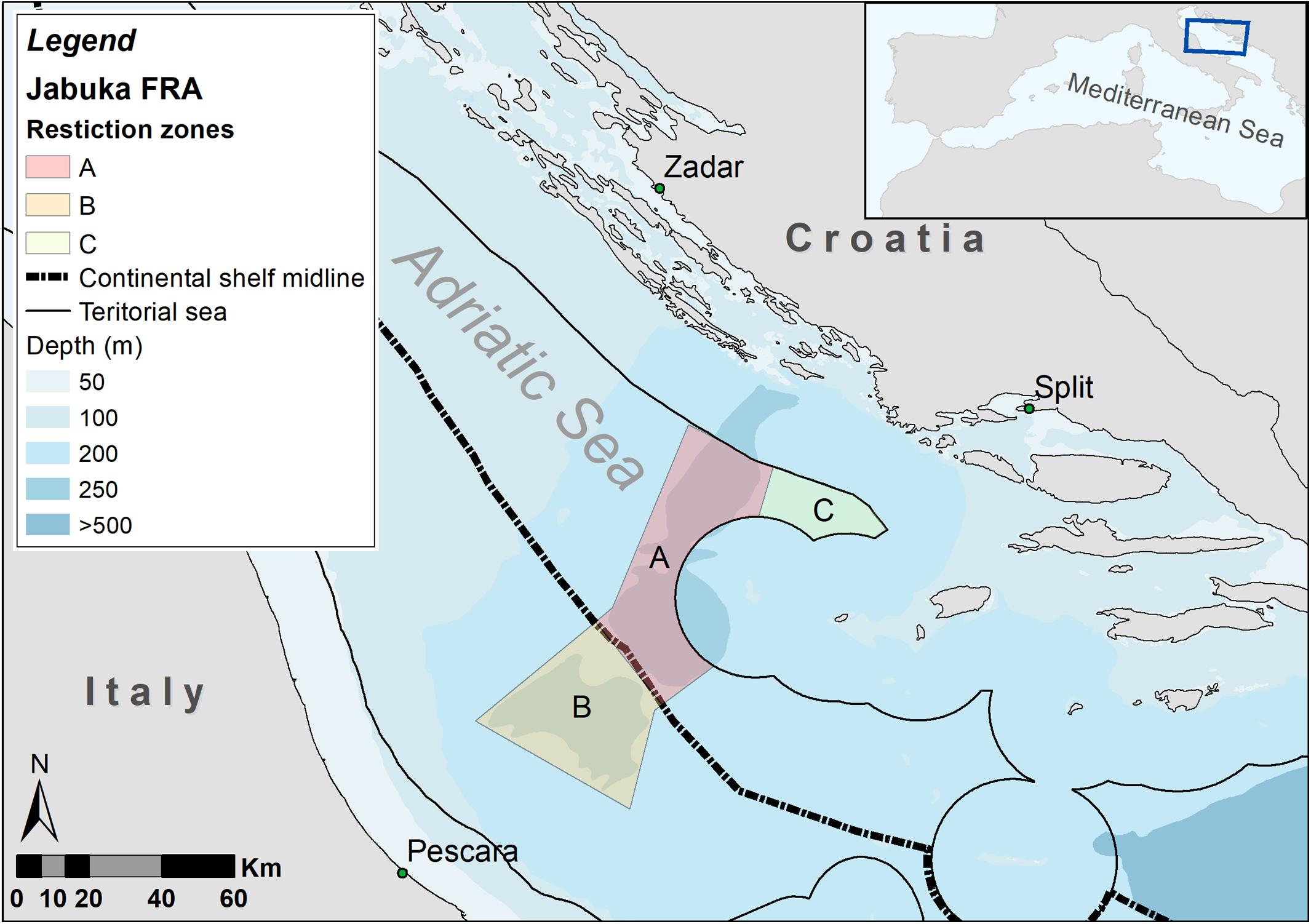
Figure 4. Jabuka pit fisheries restricted area.
Political and Strategic Considerations
As Croatia acceded to the European Union in July 2013, Jabuka Pit was proposed as one of several SCIs under the EU Habitats Directive (HR3000423). In the same period, the parties of the Convention on Biological Diversity (CBD) identified this region as an ecologically or biologically significant marine area (EBSA) (UNEP/CBD/COP/DEC/XII/22, 2014), which is also recognized by the Mediterranean regional seas program (Barcelona Convention, 1976 amended 1995). The consistent negative trend shown in the commercial fish species biomass index, and the status of the benthic resources, suggested that urgent restrictive measures were required (Vrgoč et al., 2014). Hence, scientists and authorities of Italy and Croatia negotiated for several years over the establishment of management measures in the region. Through long negotiations, Italy and Croatia finally reached an agreement to introduce a joint moratorium on all bottom fisheries at the deepest part of the Pit. The first annual agreement was effective from July 26, 2015, prohibiting any benthic fisheries. After further negotiations, the moratorium was extended, based on the scientific recommendations, until October 16, 2016. Although initial research showed that there was a limited recovery, and Croatia advocated for an additional 3 years prolongation, the moratorium was not extended. The Italian fleet resumed trawling within the area. In the same period Croatia unilaterally closed bottom fishing in the nearby Croatian territorial waters (zones c, d and e) during September and October of 2015, 2016, and 2017.
Unfortunately, the short-term closure of the fisheries did not change the unfavorable status of the fish stocks in the Jabuka Pit. As a direct result of this, bilateral negotiations finally led to new agreement between Croatia and Italy in September 2017. Both countries agreed to create a large area with both controlled and fully restricted fisheries. The new 3-year agreement was put into effect on September 1, 2017 and was due to last until August 31, 2020, with the core area fully closed to all fisheries. Due to its commercial and biological value, discussions over the management of the zones were elevated to the EU and regional level. Several proposals, including a plan from a broad coalition of non-governmental and research institutes, were made to the Scientific Advisory Committee (SAC) of the GFCM to declare Jabuka Pit as a fisheries restricted area (FRA) (FAO, 2017; MEDREACT, 2017). As fisheries management in the EU falls under the sole jurisdiction of the EC through the Common Fisheries Policy, on October 17, 2017 the GFCM adopted the EC proposal for the establishment of a FRA in the Jabuka/Pomo Pit (GFCM, 2017, Recommendation GFCM/41/2017/3). As the GFCM is a supranational body, the FRA should apply to all of the signatory states that would like to fish in the offshore waters of Italy and Croatia in the Jabuka Pit.
Lessons and Synergies
The case of Jabuka Pit shows that bilateral and collaborative approach to fisheries management can lead to beneficial resolutions for resource conservation. The elevation of the discussion to EU and GFCM level, led to international attention and support for the proposal. The presence of the EBSA also highlighted the biodiversity conservation value. Regardless of these international conservation declarations, no management measures were introduced based on them. This poses the question of the different value of these international agreements on spatial and species conservation and management. Perhaps the most significant aspect was due to the attention focused on the area by the international non-governmental and the institutional lobbying for protection.
The Dogger Bank
Background and Features
The Dogger Bank is by far the largest sandbank in the North Sea (17,000 km2) and it is shared by the United Kingdom, Netherlands, Germany, and Denmark (see Figure 5). National maritime boundaries in the area are not disputed but cross border fisheries management of the sandbank has been a source of conflict. In order to meet the EU Natura 2000 network conservation objectives, the British (UK0030352), Dutch (NL2008001), and German (DE1003301) parts of the Dogger Bank have been designated under the Habitats Directive, albeit with incompatible conservation objectives. Conversely, Denmark has not designated its part of the sandbank as they consider that it does not meet the requirement of being a relatively shallow sandbank. However, Denmark is seriously involved in the fisheries management proposal for the protected area because they have a large economic interest through their sand eel fishery on the Dogger Bank.
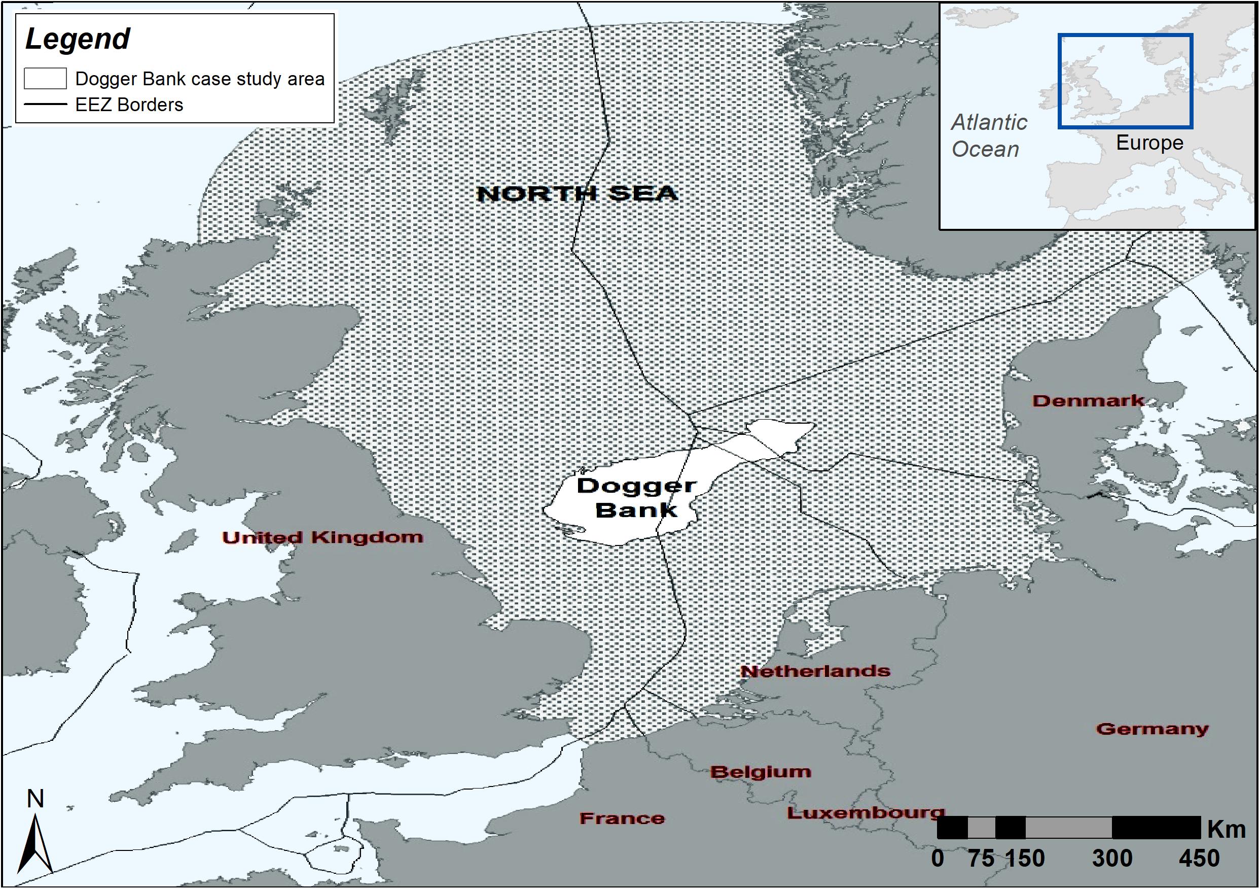
Figure 5. Dogger Bank.
Political and Strategic Considerations
To resolve the different views an intergovernmental steering group was initiated by the Netherlands, with scientific support from the International Council for the Exploration of the Sea (ICES) and the involvement of the EU and various stakeholders. Several stakeholder meetings were organized to find common ground using state of the art spatial planning tools. Although a proposal for cross border fisheries management has been agreed upon by all member states involved, it still needs to be implemented by these member states. A complicating factor is that, under the Common Fisheries Policy, fisheries measures need the approval of the collaborating Fisheries Directors of the North Sea Member States cooperating in the Scheveningen Group. This includes flag states that have an interest in the Dogger Bank but were not involved in the transboundary negotiations. The Habitats Directive requires management plans to be in place no later than 3 years after formal designation of the site. On June 19, 2019, the United Kingdom, Germany, and the Netherlands submitted this management plan, which was immediately challenged by a group of nine environmental NGO’s for allowing bottom trawling and seine fishing across the majority of Dogger Bank designated areas.
Lessons and Synergies
The process to protect the Dogger Bank through fisheries measures started in 2010 and several valuables lessons can be extracted from the process. Some interesting interpretations result from observing the process and the interactions of the actors involved. While the overarching goal of the initiative was marine conservation, for every state involved other uses of the sea, such as offshore renewable energy and fishing (and the actors behind them), had a strong impact on the process. It is interesting to mention that the United Kingdom was the country with the renewable energy interests, Denmark was the country with stronger fisheries interests and Netherlands and Germany had stronger conservation interests. Although there was no intention by these states to establish sovereignty, there was an implicit intention by each state to safeguard their own economic interests by cooperating with each other, under the overarching goal of transboundary conservation.
For instance, fishermen who were supported by Denmark, proposed that the 6% of the wind farm area in the United Kingdom area, that was not overlapping with the proposed closed areas for fishery, could be added to the closure percentages as a trade-off for other closures (Danish Fishermen’s Association et al., 2012; Caveen et al., 2013). In that instance a wind farm in United Kingdom waters meant that Denmark would lose less fishing grounds, all countries would gain extra conserved area and the United Kingdom would have one more argument to build wind farms. Although it was clear that more than one objective would be met, and there was intent from the states to cooperate, it was not enough to reach an agreement or implement it. Hence it was proposed by the parties involved that “a preferred method for weighing economic and socio economic considerations, i.e., a structured, iterative process of optimal decision-making in the face of uncertainty, should be developed” (NSRAC, 2012) to facilitate an agreement.
As such, a method that would fairly allocate surplus from cooperation among involved parties would be recommendable (Kyriazi et al., 2017). Other important lessons learned were: the importance of agreed on Terms of Reference, using the best available “usable” data, sharing data and knowledge with all involved and clearly distinguishing between content and negotiation. In addition, formulating close collaboration with the involved stakeholders, i.e., NGO’s and fishing industry, and not with decision makers, was crucial. Currently it is unclear how decision makers reflect on the above-mentioned process.
Selvagens Islands
Background and Features
The Selvagens Islands are located in the Northeast Atlantic, 293 km from Madeira Island, and 180 km north of the Canary Archipelago (see Figure 6). It is the southernmost part of the Portuguese territory, and its administration is the responsibility of the Madeira Autonomous Region (Sim-Sim et al., 2010). These islands are home to some endemic, threatened and vulnerable species, giving Selvagens Islands an exceptional ecological and natural value. The habitats are very well preserved as a unique example of pristine habitats in the Atlantic, with many species rare at the global scale (Friedlander et al., 2016). The archipelago is influenced by the general circulation of the North Atlantic surface currents, playing an essential role on larval dispersal of species from many geographical origins (Marine Conservation Institute, 2019) These islands are, therefore “stepping stones” for colonization of new areas (Almada et al., 2015).
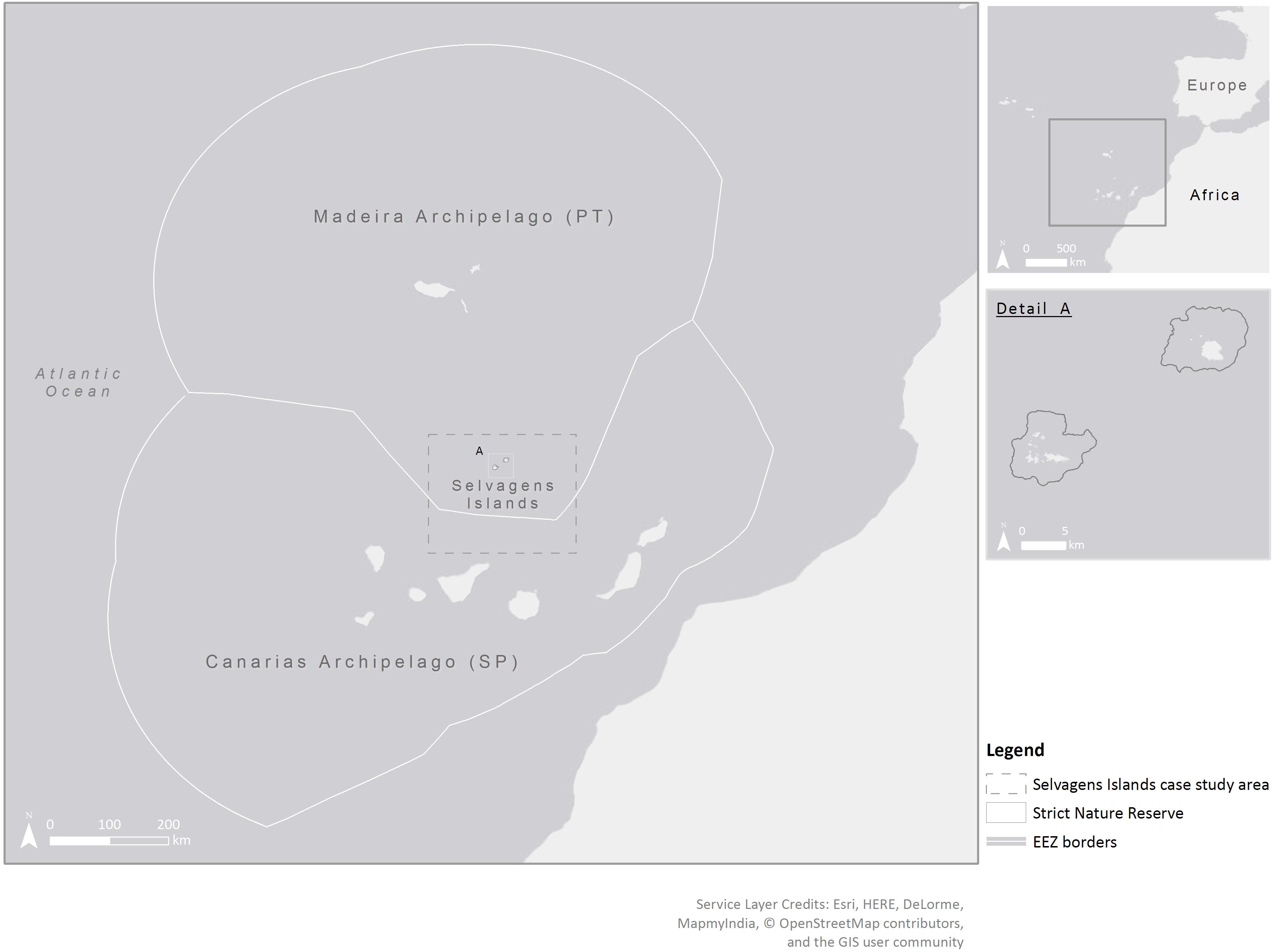
Figure 6. Selvagens Islands.
Political and Strategic Considerations
In 1971, the Selvagens archipelago was classified as a Strict Nature Reserve to the depth of 200 m, with strong restrictions for the use of both marine and terrestrial areas. In deeper waters, the protection of many species is very low, exposing them to threats related to high fishing pressure (Friedlander et al., 2016). The Selvagens Nature Reserve is the oldest nature reserve in Portugal and was recently included in the EU Natura 2000 Network as a SAC (PTSEL0001) and a SPA (PTZPE0062). At present, these Islands are managed and patrolled by the Madeira Natural Park Service (Friedlander et al., 2016; UNESCO, 2019). Due to their outstanding natural value, the Portuguese government has recently submitted a proposal to UNESCO to classify part of the islands and surroundings waters, down to 1000 m depth, as a World Heritage Natural Site (UNESCO, 2019). This proposal is currently under review.
Although the Permanent Commission of International Maritime Law has already settled sovereignty of the Selvagens Islands in 1938, the Islands are still disputed by Spain. The dispute, under the auspices of the UNCLOS, Article 121, is whether they are considered as islands or rocks. This is defined by whether they are inhabited or uninhabited, and/or have some kind of economic activity. This has implications for the southernmost border of the Portuguese EEZ (Friedlander et al., 2016). Spain argues that the Selvagens Islands cannot be classified as anything but rocks. Based on this assumption, a median line would be delineated between the Canaries and Madeira, with the Selvagens Islands completely within the Spanish EEZ. This would allow Spanish fishers from the Canary Islands to fish in the waters around the Selvagens Islands. Conversely, Portugal considers this archipelago as permanently inhabited. On Selvagem Grande there is a permanent research station with two rangers all year round, while in Selvagem Pequena there are two rangers between May and October (Friedlander et al., 2017). Accordingly, the Portuguese government recognizes a 200 nm EEZ around the islands. While the current extension of the Portuguese continental shelf does not apply to the Selvagens Islands, it should be evaluated following the advice of the Commission on the Limits of the Continental Shelf (Santana, 2016).
The marine area surrounding the islands is exposed to threats from fishing pressure by Madeiran and Spanish vessels. These vessels mostly target tuna and other pelagic species, but may also illegally fish within the reserve boundaries. The Portuguese government intends to enlarge the MPA to fulfil their CBD commitments to protect 10% of the EEZ by 2020 (Friedlander et al., 2016). Although the commitment is about conservation within the EEZ, Portugal also wants to set MPAs outside the EEZ to protect 30% of the maritime territory (including the extended continental shelf) by 2030. If a decision on the extension of the continental shelf favors the Portuguese position there might be an opportunity to enlarge the MPA and implement conservation measures in a broader marine area, whether in the water column or the seabed. Conversely, if the ruling supports the Spanish position, it will enable the extension of Spanish EEZ favoring their strategic objectives for this area.
Lessons and Synergies
Nature conservation goes far beyond sovereignty disputes between countries. However, its application depends highly on who had the sovereign right to act in an area. In this case study there are economic interests supporting the political positions of both countries. However, the complexity of marine ecosystems and their processes do not recognize jurisdictional boundaries and require serious effort for conservation. To follow the holistic paradigm of ecosystem-based management it is crucial that states have the ability to cooperate on conservation issues. This would require that the legal framework for international ocean governance supports and reconciles the interests of the parties involved, and yet remain flexible enough to be applicable to different sea regions.
Discussion
Spatial management and conservation measures such as MPAs, FRAs, and OECMs are important components in the effort to protect and rehabilitate threatened marine ecosystems, and increase biodiversity and abundance of marine species (Halpern, 2003; Claudet et al., 2008; Pipitone et al., 2014; Portman et al., 2016). While these initiatives can bring states together, it is clear that these mechanisms can also be used in a manner that they were not originally conceived. In some cases, they appear to have been used as a means to promote claims of sovereignty in disputed areas, while being lauded as marine conservation tools. In this instance conservation measures could be perceived as a form of “ocean grabbing” (sensu Bennett et al., 2015), particularly where governance arrangements are negligible. In some of the case studies, the attempt to “grab” a marine space is clear. In other instances, it is less obvious, such as an attempt to undermine the rights of other states to access marine resources, or cooperation for an overall transboundary conservation objective may implicitly serve individual economic interests of the counties involved.
In each of the case studies examined, there are varying forms of governance frameworks applied. Often the same legislative tools have been used by different actors, with different interpretations and applications, to justify their claims.
At the global scale, the UNCLOS provides the framework for the definition of marine space (Douvere and Ehler, 2009). Yet, due to its complexity, and the need for nation states to negotiate, its application is open to interpretation (Friedheim, 1993). In four of the six case studies, varying applications of the Articles of the UNCLOS have been used. For instance, in the case of the Southern Waters of Gibraltar, the lack of acknowledgment of the three nautical mile territorial sea is an underlying function of the dispute. The current absence of Spanish recognition of this zone undermines the conservation objective and the potential for cooperation in this ecologically important area. The application of different aspects of UNCLOS by Italy and Tunisia in the Mammellone Bank provides another example. The position of Tunisia appears to be consistent with Article 6.2 of the CFCLRHS, which establishes the right of any coastal state to take measures to regulate stocks in areas of the High Seas contiguous to its own territorial waters. However, the position of Italy appears to be contrary to the provisions of Article 6.3 of the CFCLRHS. The establishment of the ecological protection area was unilateral and not negotiated with Tunisia. The use of the CFCLRHS as a tool is also curious as Italy had not yet signed the convention and Tunisia had not ratified it at that time. The implementation of a fishery reserve in the High Seas by Italy is legitimate under Article 117 of the UNCLOS (Montego Convention of 1982) and resembles the case of the establishment of an EPZ by France (decree No 2004-33 of 8 January 2004). In the latter case, Chevalier (2005) interprets the French designation as a way to assert a portion of the rights and controls that would apply if an EEZ were declared. Hence, Italy could also claim some rights in the Mammellone Bank in the perspective of a future EEZ claim. These attempts to establish unilateral rights on Mammellone Bank resources resonate with the ocean grabbing concept and highlight the disconnection of the legislative tools and the lack of an effective governance framework.
The situation in the Selvagens Islands is even more complex, with implications for the definition of both the continental shelf and EEZ based on the issue of recognizing the islands as inhabited (Article 121 of the UNCLOS). This illustrates a different interpretation of the UNCLOS criteria by Portugal and Spain. Depending on the arbitration, and the decision of the UN Commission on the Limits of the Continental Shelf, one of the two countries will have the opportunity to enlarge its maritime territory and extend its political influence over the area. Conversely, in the Israel-Lebanon case, as Israel is not a signatory to the UNCLOS and refuses to utilize alternative mediation or arbitration for the border delimitation, which would suggest that the dispute will run on and become more difficult to resolve. In both instances, these disputes have implications for the Portuguese and Israeli commitments to the CBD, respectively.
The maritime jurisdictional picture of the Mediterranean appears particularly complex with the designation of marine zones beyond the territorial sea, for fishery and conservation purposes, and EEZs. This has created a fragmentation of rights and increased tension among the States (UNEP-MAP-RAC/SPA, 2011). Of the four Mediterranean case studies, three are considered as EBSAs: Rosh Hanikra in the Eastern Levantine Canyons, the Mammellone Bank within the Sicilian Channel, and the Jabuka Pit. While the definition of the EBSAs has been led by the CBD, the Barcelona Convention of the Mediterranean Sea has adopted the process. This is an instance where a global framework is being operationalized at regional level. The similarities between the definition of the EBSAs and specially protected areas of Mediterranean importance (SPAMIs), as identified under the SPA/BD protocol of the Barcelona Convention, were highlighted at an expert workshop of UNEP in 2009 (UNEP/CBD, 2009). Specifically, the acceptance of the scientific criteria of the CBD EBSAs were seen to support the development of a short-list of potential SPAMI sites in the area beyond national jurisdiction (ABNJ). While there remain questions over the effectiveness of the EBSAs for conservation means, without direct management interventions (Johnson et al., 2018), the SPA/BD protocol caveats provide an intuitive solution to bring states together for conservation. As the link between the EBSAs and the SPAMIs appears to be increasingly close, perhaps there is the potential to feedback these caveats back into the CBD for recognition at a global scale. This would be particularly timely considering the ongoing discussions over the role of adjacency rights for states with jurisdictions bordering the ABNJ (Dunn et al., 2017).
The EU Habitats Directive is often cited as ground breaking (Friedrichs et al., 2018). However its application within the marine environment is far from complete (Evans et al., 2011). While the directive has been applied in all of the case studies involving EU states as protagonists there remain conflicts. This is because its application as a conservation tool is open to interpretation by each EU Member State (Fraschetti et al., 2018). For the Dogger Bank three of the four EU states have applied the same directive, for the same habitats and species, but in different ways. In the case of Denmark, it has not even been applied. This has not precluded the European Commission from preferring a single integrated management approach to the entire Natura 2000 Dogger Bank (Dogger Bank Background Document, 2016). In the Southern Waters of Gibraltar, Spain and the United Kingdom have opposing management regimes in the same area, with different conservation objectives, utilizing the same directive. In Portugal, the Selvagens Islands classification as a Nature Reserve and its integration in the Natura 2000 network as an SPA and SAC has not been affected by Spanish actions. This is because the current Natura 2000 site sits outside the disputed area. Finally, in the case of Jabuka Pit the Croatian Natura 2000 site was superseded by GFCM designation of the FRA, fishery economics overruling conservation concerns.
In most of the case studies, economics has played a key role. The impact of a fisheries crisis in the Jabuka Pit eventually brought Italy and Croatia together through the GFCM to resolve a threat to the common resource. Conversely, fisheries management is the driving force behind the conflict in the Dogger Bank. Likewise, in the Southern Waters of Gibraltar, conflicting fishery rules in the two Natura 2000 sites undermine the conservation objectives. In the Mammellone Bank, conflict over the fishery resources divided Italy and Tunisia. The incursion of vessels from Libya and Egypt has supposedly decreased the profitability of the area as a fishing ground. This, in turn, has made collaboration between Italy and Tunisia easier, and allowed the Sicilian FPD to act as a facilitator, which is now gaining momentum after decades of stagnation. The potential for oil and gas exploration is unknown for the Mammellone Bank, but it could constitute a future source of conflict. Finally, the conflict over oil and gas reserves in the region of the Rosh Hanikra MPA is clearly one of the factors fundamental in the disagreement between Israel and Lebanon.
In two of the case studies, the initiatives were given strong scientific support. In the Dogger Bank, the process is centered around a scientific approach, notably through the ICES workshop series. This ensured scientific input through the commissioning of literature reviews and data compilations. In the final stage, the ICES scientific Advisory Committee was requested to present formal scientific advice on the proposed fisheries measures (Dogger Bank Background Document, 2016). In the Jabuka Pit long-term fisheries research played a key role in supporting the GFCM designation along with the role of NGOs providing complementary data and support.
Stakeholder engagement in environmental decision-making is crucial to the long-term success of conservation efforts (Giakoumi et al., 2018). However, stakeholder involvement is not always an unqualified success, it is often dependent on the complexity of the issue (Khwaja, 2001). In the six case studies, there are large differences in the capacity of the stakeholders engaged. For the Dogger Bank, key stakeholders from four key communities: fishing industry; science; environmental/nature organizations and government, were involved from the very early stages. The industrial stakeholder groups were predominantly from fishing, shipping and energy, all of which played a role in the negotiations. Invitations and participation in the meetings were well balanced across these sectors and there was considerable effort made to facilitate their participation. This involved stakeholders from the Member States directly cooperating in the proposal (Netherlands, United Kingdom, and Germany), as well as from Denmark, Ireland and the ICES community (Dogger Bank Background Document, 2016). In the Jabuka Pit, international, regional and local NGOs played an important lobbying role combining with the universities and other institutions that provided much of the knowledge for the conservation objectives.
In the Rosh Hanikra MPA, the designation was discussed with fishers who showed little resistance to the concept in the planning committee. This was an important main reason for it being the first of the large MPAs to be approved. The lack of objection stemmed mainly from the fact that fishers had already been limited in the near shore area of the previous MPA. The proximity of the border and military testing zone also appears to have discouraged other stakeholder use (Engert, personal communication). In the case of the Mammellone Bank, a stakeholder group, working through the FPD in Mazara del Vallo in cooperation with the Sicilian Department of Fisheries, has sought to fill the governance gap left by the end of the bilateral agreements between the Italian and Tunisian governments. The FPD has organized meetings to pave the way toward the shared management of the fish stocks. The proposal of the Department is to establish a “fish stock recovery area” within a suitable management plan shared by Italy and Tunisia.
The geographical position of some of the case studies may have expedited their role as conservation areas. The peripheral location of the Rosh Hanikra MPA, in the northern edge of the state, contributed to it being the first of the six new MPAs to be designated in Israel (Portman and Teff-Seker, 2017). While the unique physical features of the area make the Rosh Hanikra MPA highly valuable ecologically, it could be considered a low-hanging fruit with regards to fulfilling Israeli international biodiversity commitments. Likewise, the peripheral location of the Selvagens Islands, after the resolution of the dispute between Portugal and Spain, may allow for a collaborative conservation action between the countries. The conservation of ecosystems and marine resources, particularly in this area, which is an area of ecological continuum, requires transboundary cooperation. The Mammellone Bank is also located peripherally from both Italian and Tunisian mainland. This location makes it high cost and low revenue to visit, hence transboundary conservation may have a role to play in the future management of the area. Conversely, the highly important strategic position of the Southern Waters of Gibraltar area may undermine the chance of any agreement between the United Kingdom and Spain.
Conclusion
In the absence of clear guidance from the IUCN for transboundary marine conservation it is up to cooperating states to devise methods to equitably protect these shared regions. One way is to anchor governance regimes within a stable overarching institutional framework (Arafeh-Dalmau et al., 2017). While the UNCLOS and the CBD may provide this at the global level, it is clear that these instruments are open to interpretation. Regional seas agreements and regional fisheries management organizations appear to provide a better forum for neighboring states to air grievances, arrange face-to-face negotiations and develop cooperation, outside the global spotlight (Kirkman and Mackelworth, 2016). Yet, the use of the Habitats Directive by the various EU states also shows that manipulation of the system can also occur at macro-regional scale. Of course, arbitration is often cited as the final step to resolve a dispute, but it rarely satisfies both or either party, and nearly always results in worse relations between the states involved (Mackelworth, 2016).
The increasing interest in these peripheral areas reflects the push for marine space by both industry and the state. Ocean grabbing in this instance involves disputes between parties based on arguments over the balance of historic use rights or adjacency. It is clear that some transboundary conservation initiatives are being used as a tool to extend the political influence and exert pressure on other states. This is often related to the imbalance of power between the parties involved. Using a conservation caveat, to set aside sovereignty and focusing on the environment and mutual economic development, rather than pandering to special interests and political strategies, could help to balance power and normalize relations between states. The adoption of such a caveat written into individual conservation proposals, similar to the one used by the Antarctic agreement and the Barcelona Convention, could provide clarity and security for all of the partner states. This can be assisted by the presence of strong science and engagement, which can help mobilize the appropriate management processes, raise awareness and find synergies to fulfil conservation aims.
Author Contributions
PM conceptualized the study and led the workshops in Lisbon, Texel, and Nicosia to develop the process with the co-authors. YT and MP developed the case study 1. TV and GD’A developed case study 2. MM, FA, and CP developed the case study 6. DF and SW developed the case study 3. DG, ZK, and BR developed the case study 5. DH developed the case study 4 and created the graphics. All authors contributed to the writing and editing of the manuscript.
Funding
MM was supported by the Portuguese Foundation for Science and Technology (FCT), with a Ph.D. grant (SFRH/BD/138422/2018). MM, FA, and CP would like to acknowledge FCT/MCTES through national funds and FEDER co-funding, within the PT2020 Partnership Agreement and Compete 2020, for the financial support to CESAM (Grant No. UID/AMB/50017/2019).
Conflict of Interest
The authors declare that the research was conducted in the absence of any commercial or financial relationships that could be construed as a potential conflict of interest.
Acknowledgments
The authors would like to acknowledge the support of the COST Action 15121 “Advancing marine conservation in the ECS” (MarCons; http://www.marcons-cost.eu) and the two reviewers and the editor for assisting with the conclusion of this work. DF and SW would like to thank Dr. Keith Bensusan and Mr. Karl Netto for their input on case study 3.
Supplementary Material
The Supplementary Material for this article can be found online at: https://www.frontiersin.org/articles/10.3389/fmars.2019.00759/full#supplementary-material
References
Almada, F., Abecassis, D., Villegas-Rios, D., and Henriques, S. (2015). Ichthyofauna of the Selvagens Islands. Do small coastal areas show high species richness in the northeastern Atlantic? Mar. Biol. Res. 11, 49–61. doi: 10.1080/17451000.2014.889306
Arafeh-Dalmau, N., Torres-Moye, G., Seingier, G., Montaño-Moctezuma, G., and Micheli, F. (2017). Marine spatial planning in a transboundary context: linking baja california with california’s network of marine protected areas. Front. Mar. Sci. 4:150. doi: 10.3389/fmars.2017.00150
Auster, P. J., and Shackell, N. L. (1997). “Fishery reserves,” in Northwest Atlantic Groundfish: Perspectives on a Fishery Collapse, eds J. Boreman, B. S. Nakashima, J. A. Wilson, and R. L. Kendall, (Maryland, American Fisheries Society), 159–166.
Ayat, K. (2015). Lebanon Pushes for Resumption of US Efforts to Solve Lebanon-Israel Maritime Border Dispute. Natural Gas Europe. Available at: http://www.naturalgaseurope.com/lebanon-pushes-resumption-us-efforts-lebanon-israel-maritime-border-dispute-24550 (accessed July 9, 2015).
Ben-David, A. (2017). ‘Moving the Border’, Yediot Aharonot. Available at: http://www.yediot.co.il/articles/0,7340,L-4937757,00.html (accessed March 20, 2017).
Bennett, N. J., Govan, H., and Satterfield, T. (2015). Ocean grabbing. Mar. Policy 57, 61–68. doi: 10.1016/j.marpol.2015.03.026
Buljan, M., and Zore-Armanda, M. (1971). Osnovi Oceanografije I Pomorske Meteorologije. Croatia: Institut za oceanografiju i ribarstvo.
Carius, A., Feil, M., Switer, J., Rekacewicz, P., Rucevska, I., Sevaldsen, P., et al. (2003). Environment and Security, Transforming Risks into Cooperation: The Case of Central Asia and South Eastern Europe. Vienna: OSCE.
Caveen, A. J., Fitzsimmons, C., Pieraccini, M., Dunn, E., Sweeting, C. J., Johnson, M. L., et al. (2013). Diverging strategies to planning an ecologically coherent network of MPAs in the North Sea: the roles of advocacy, evidence and pragmatism in the face of uncertainty. Adv. Mar. Biol. 69, 325–370. doi: 10.1016/B978-0-12-800214-8.00009-8
Claudet, J., Osenberg, C. W., Benedetti-Cecchi, L., Domenici, P., García-Charton, J. A., Pérez-Ruzafa, Á., et al. (2008). Marine reserves: size and age do matter. Ecol. Lett. 11, 481–489. doi: 10.1111/j.1461-0248.2008.01166.x
Danish Fishermen’s Association, Dutch Fisheries Foundation, National Federation of Fishermen’s Organisations, Deutscher Fischerei Verband (2012). Fisheries Spatial Management Measures for the Dogger Bank SAC: Fishing Industry Amendment Proposal. German: Dogger Bank Steering Group (DBSG).
Department of the Environment, (2012). Initial Assessment and Proposals for Good Environmental Status of British Gibraltar Territorial Waters. HM Government of Gibraltar. Available at: https://www.gibraltar.gov.gi/new/sites/default/files/1/15/Marine_Strategy_Framework-Initial_Assessment-Final_version_8-7-13.pdf (accessed November 27, 2019).
Diz, D., Johnson, D., Riddell, M., Rees, S., Battle, J., Gjerde, K., et al. (2018). Mainstreaming marine biodiversity into the SDGs: the role of other effective area-based conservation measures (SDG 14.5). Mar. Policy 93, 251–261. doi: 10.1016/j.marpol.2017.08.019
Dogger Bank Background Document (2016). Background Document to the Draft Joint Recommendation for Offshore Fisheries Management on the International Dogger Bank Under the Revised Common Fisheries Policy. Available at: https://lbst.dk/fileadmin/user_upload/NaturErhverv/Filer/Fiskeri/Natura_2000_hav/Fiskeriregulering_i_andre_lande/20160531_Dogger_Bank_Background_Document_final.pdf (accessed March 18, 2019).
Douvere, F., and Ehler, C. N. (2009). New perspectives on sea use management: initial findings from European experience with marine spatial planning. J. Environ. Manag. 90, 77–88. doi: 10.1016/j.jenvman.2008.07.004
Dudley, N., Stolton, S., Belokurov, A., Krueger, L., Lopoukhine, N., Mackinnon, K., et al. (2010). Natural Solutions: Protected Areas Helping People Cope with Climate Change. Natural Solutions: Protected Areas Helping People Cope with Climate Change. Gland: IUCN-WCPA.
Dunn, D. C., Crespo, G. O., Vierros, M., Freestone, D., Rosenthal, E., Roady, S., et al. (2017). Adjacency: How Legal Precedent, Ecological Connectivity, and Traditional Knowledge Inform Our Understanding of Proximity. Available at: https://nereusprogram.org/reports/policy-brief-adjacency-how-legal-precedent-ecological-connectivity-and-traditional-knowledge-inform-our-understanding-of-proximity/ž (accessed November 27, 2019).
Eiran, E. (2017). Between land and sea: spaces and conflict intensity. Territ. Politic. Gov. 5, 190–206. doi: 10.1080/21622671.2016.1265466
Evans, D., MacSharry, B., and Opermanis, O. (2011). “Current status of the habitats directive marine special areas of conservation network,” in Progress in Marine Conservation in Europe 2009, eds H. von Nordheim and J. C. K. Krause Maschner, (Bonn: BfN Skripten-Bundesamt für Naturschutz).
FAO (2011). Fisheries Management 4. Marine Protected Areas and Fisheries in FAO Technical Guidelines for Responsible Fisheries. FAO: Rome.
FAO (2017). Report of the nineteenth session of the Scientific Advisory Committee On Fisheries Ljubljana, Slovenia, 16–19 May 2017; Fipi/R1209(Bi) FAO Fisheries And Aquaculture Report, General Fisheries Commission For The Mediterranean 184. Available at: http://www.fao.org/3/a-i7889b.pdf (accessed November 27, 2019).
Foley, P., and Mather, C. (2018). Ocean grabbing, terraqueous territoriality and social development. Territ. Politic. Gov. 7, 297–315. doi: 10.1080/21622671.2018.1442245
Fortuna, C. M., Cañadas, A., Holcer, D., Brecciaroli, B., Donovan, G. P., Lazar, B., et al. (2018). Coherence of the European Union marine Natura 2000 network for wide-ranging charismatic species: a Mediterranean case study. Front. Mar. Sci. 5:356. doi: 10.3389/fmars.2018.00356
Franco, J., Buxton, N., Vervest, P., Feodoroff, T., Pedersen, C., Reuter, R., and Barbesgaard, M.C. (2014). The Global Ocean Grab: A Primer. Available at: http://www.tni.org/briefing/global-ocean-grab-primer-0 (accessed April 11, 2019).
Fraschetti, S., Pipitone, C., Mazaris, A. D., Rilov, G., Badalamenti, F., Bevilacqua, S., et al. (2018). Light and shade in marine conservation across European and Contiguous Seas. Front. Mar. Sci. 5:420. doi: 10.3389/fmars.2018.00420
Friedheim, R. L. (1993). Negotiating the New Ocean Regime. Columbia, CS: University of South Carolina Press.
Friedlander, A., Ballesteros, E., Clemente, S., Estep, A., Gonçalves, E., Rose, P., et al. (2016). Marine Biodiversity and Ecosystem Health of Ilhas Selvagens, Portugal. Washington, DC: The Regional Government of Madeira.
Friedlander, A., Ballesteros, E., Clemente, S., Gonçalves, E., Estep, A., Rose, P., et al. (2017). Contrasts in the marine ecosystem of two Macaronesian islands: a comparison between the remote Selvagens reserve and Madeira Island. PLoS One 12:e0187935. doi: 10.1371/journal.pone.0187935
Friedrichs, M., Hermoso, V., Bremerich, V., and Langhans, S. D. (2018). Evaluation of habitat protection under the European Natura 2000 conservation network – The example for Germany. PLoS One 13:e0208264. doi: 10.1371/journal.pone.0208264
GFCM (2017). Recommendation GFCM/41/2017/3 On The Establishment Of A Fisheries Restricted Area In The Jabuka/Pomo Pit In The Adriatic Sea. General Fisheries Commission For The Mediterranean Report Of The Forty-First Session Budva, Montenegro, 16 – 20 October 2017, Food And Agriculture Organization Of The United Nations Rome, 2018, 175. Available at: www.Fao.Org/3/I8500en/I8500en.Pdf (accessed November 27, 2019).
Giakoumi, S., McGowan, J., Mills, M., Beger, M., Bustamante, R., Charles, A., et al. (2018). Revisiting “success” and “failure” of marine protected areas: a conservation scientist perspective. Front. Mar. Sci. 5:223. doi: 10.3389/fmars.2018.00223
Gilad, M. (2016). A Vast Marine Reserve was Declared in Rosh Hanikra, will it Succeed in Protecting the Sea? Available at: https://www.haaretz.co.il/travel/.premium-1.3031471 (accessed August 8, 2016).
Groisman, M. (2016). Lebanon Pushes for French Mediation in Its Maritime Border Dispute with Israel, Jerusalem Post. Available at: http://www.jpost.com/Arab-Israeli-Conflict/Lebanon-pushes-for-French-mediation-in-its-maritime-border-dispute-with-Israel-451478 (accessed April 17, 2016).
Gutiérrez Castillo, V. L. (2008). “Conflictos de delimitación de espacios marinos en el Magreb y la explotación de sus recursos,” in Cursos de Derechos Humanos de Donostia-San Sebastian Vol. 9, ed. J. Soroeta Liceras (Bilbao: Universidad del Pais Vasco), 84–112. Available at: https://dialnet.unirioja.es/servlet/articulo?codigo=2942207 (accessed November 27, 2019).
Halpern, B. S. (2003). The impact of marine reserves: do reserves work and does reserve size matter? Ecol. Appl. 13, 117–137. doi: 10.1890/1051-0761(2003)013
Hammill, A., and Besançon, C. (2007). “Measuring peace park performance: definitions and experiences,” in Peace Parks: Conservation and Conflict Resolution, ed. S. Ali, (Cambridge, MA: MIT Press).
Israel Nature Parks Authority [INPA] (2012). Nature Conservation Policy in the Mediterranean Sea- Marine protected Areas as a Tool for Environment and Biodiversity Conservation in the Mediterranean Sea. Jerusalem: Israel Nature Parks Authority.
IUCN (2012). Lebanon’s Marine Protection Area Strategy. Available at: http://www.mpatlas.org/region/country/LBN/ (accessed June 5, 2019).
IUCN (2014). Declaring Two Marine Protected Areas in Lebanon. Available at: https://www.iucn.org/es/node/16861 (accessed June 5, 2019).
Jay, S., Alves, F. L., O’Mahony, C., Gomez, M., Rooney, A., Almodovar, M., et al. (2016). Transboundary dimensions of marine spatial planning: fostering inter-jurisdictional relations and governance. Mar. Policy 65, 85–96. doi: 10.1016/j.marpol.2015.12.025
Johnson, D. E., Froján, C. B., Turner, P. J., Weaver, P., Gunn, V., Dunn, D. C., et al. (2018). Reviewing the EBSA process: improving on success. Mar. Policy 88, 75–85. doi: 10.1016/j.marpol.2017.11.014
Katsanevakis, S., Mackelworth, P., Coll, M., Fraschetti, S., Maèiæ, V., Giakoumi, S., et al. (2017). Advancing marine conservation in European and contiguous seas with the MarCons action. Res. Ideas Outcomes 3:e11884. doi: 10.3897/rio.3.e11884
Khwaja, A. I. (2001). “Can good projects succeed in bad communities? collective action in the Himalayas,” in Working Paper Series rwp01-043, ed. F. John, (Cambridge: Harvard University).
Kirkman, H., and Mackelworth, P. (2016). “Defining approaches for the management of large Marine systems,” in Marine Transboundary Conservation and Protected Areas, ed. P. Mackelworth, (London: Routledge), 35–50.
Kyriazi, Z., Lejano, R., Maes, F., and Degraer, S. (2017). A cooperative game-theoretic framework for negotiating marine spatial allocation agreements among heterogeneous players. J. Environ. Manag. 187, 444–455. doi: 10.1016/j.jenvman.2016.11.011
Mackelworth, P. (2012). Peace parks and transboundary initiatives: implications for marine conservation and spatial planning. Conserv. Lett. 5, 90–98. doi: 10.1111/j.1755-263X.2012.00223.x
Mackelworth, P. (2016). Marine Transboundary Conservation and Protected Areas. London: Routledge, 314.
Mackelworth, P., Portman, M. E., Fa, D. A., Holcer, D., Vega Fernández, T., Augustowski, M., et al. (2018). Review Document of International Instruments for Conservation within the MarCons region, Draft 27.06.2018, Deliverable 5.1 of the COST Action CA15121 ‘Advancing Marine Conservation in the European and Contiguous Seas (MarCons)’. 40. Available at: http://www.marcons-cost.eu/images/miscfiles/Marcons_D5.1_%202018_11_05.docx (accessed November 27, 2019).
MacKinnon, D., Lemieux, C. J., Elliott, C., Haas, J., Langlois, H., Lazaruk, T., et al. (2015). Canada and aichi biodiversity target 11: understanding ‘other effective area-based conservation measures’ in the context of the broader target. Biodivers. Conserv. 24, 3559–3581 doi: 10.1007/s10531-015-1018-1
Marine Conservation Institute (2019). Ilhas Selvagens Nature Reserve (Reserva Natural). Available at: http://www.mpatlas.org/mpa/sites/6575/ (accessed January 10, 2019).
McClanahan, T. (2004). The limits to beyond boundaries. Aquat. Conserv. Mar. Freshw. Ecosyst. 14, 1–4. doi: 10.1002/aqc.613
McDowell, D. (1998). “Opening remarks by the IUCN director general,” in Proceedings of the International Conference on Transboundary Protected Areas as a Vehicle for International Co-operation, Somerset West.
MEDREACT (2017). “Appendix 14. Proposal for a GFCM fisheries restricted area (FRA) essential fish habitats in the central Adriatic Jabuka/Pomo pit,” in Proceedings of the FAO Fisheries and Aquaculture Report No. 1209: GFCM – Report of the 19th session of the Scientific Advisory Committee on Fisheries (Ljubljana: FAO/UN), 175. Available at: http://www.fao.org/3/a-i7889b.pdf (accessed November 27, 2019).
Micheli, F., Levin, N., Giakoumi, S., Katsanevakis, S., Abdulla, A., Coll, M., et al. (2013). Setting priorities for regional conservation planning in the Mediterranean Sea. PLoS One 8:e59038. doi: 10.1371/journal.pone.0059038
MNIEWR (2016). Minister Steinitz Promotes Opening the Sea: The Oil Council Approved New Search Areas for Gas and Oil in Israel’s EEZ Today’, 2016. Available at: http://energy.gov.il/AboutTheOffice/SpeakerMessages/Pages/GxmsMniSpokesmanOSAug16.aspx (accessed November 27, 2019).
NSRAC (2012). Fisheries management in relation to nature conservation for the combined area of 3 national natura 2000 Sites (SACs) on the dogger bank. Paper Presented at the Final Position of the North Sea Regional Advisory Council (NS RAC), Oxford.
Pipitone, C., Badalamenti, F., Fernandez, T. V., and D’Anna, G. (2014). Spatial management of fisheries in the mediterranean sea: problematic issues and a few success stories. Adv. Mar. Biol. 69, 371–402 doi: 10.1016/b978-0-12-800214-8.00010-4
Popova, E., Vousden, D., Sauer, W. H., Mohammed, E. Y., Allain, V., Downey-Breedt, N. et al. (2019). Ecological connectivity between the areas beyond national jurisdiction and coastal waters: safeguarding interests of coastal communities in developing countries. Mar. Policy 104, 90–102. doi: 10.1016/j.marpol.2019.02.050
Portman, M., and Teff-Seker, Y. (2016). Remembering the Red Sea Marine Peace Park, in Marine Transboundary Conservation and Protected Areas. Abingdon: Routledge, 101–122.
Portman, M., Shabtay-Yanai, A., and Zanzuri, A. (2016). Incorporation of socio-economic features’ ranking in multicriteria analysis based on ecosystem services for marine protected area planning. PLoS One 11:e0154473. doi: 10.1371/journal.pone.0154473
Portman, M. E., and Teff-Seker, Y. (2017). Factors of success and failure for transboundary environmental cooperation: projects in the Gulf of Aqaba. J. Environ. Policy Plan. 19(6), 810–826. doi: 10.1080/1523908X.2017.1292873
Ravid, B. (2011). U.S. Backs Lebanon on Maritime Border Dispute with Israel. Available at: http://www.haaretz.com/u-s-backs-lebanon-on-maritime-border-dispute-with-israel-1.372377 (accessed July 10, 2011).
Salamone, L. (2004). Polizia Marittima e Vigilanza Pesca in Acque Nazionali ed Internazionali: Il Contenzioso Italo-Tunisino Sullo Sfruttamento Delle Risorse Biologiche Nel Mediterraneo. Diritto and Diritti. Available at: https://www.Diritto.it (accessed 13/09/2010).
Sas, E., Fischhendler, I., and Portman, M. E. (2010). The demarcation of arbitrary boundaries for coastal zone management: the israeli case. J. Environ. Manag. 91, 2358–2369. doi: 10.1016/j.jenvman.2010.06.027
Scovazzi, T. (1999). Marine Specially Protected Area: The General Aspects and the Mediterranean Regional System. The Hague: Kluwer Law International.
Shine, C., and Scovazzi, T. (2007). Mediterranean Countries’ Needs for Legal, Policy and Institutional Reforms to Strengthen the Management of Existing Marine Protected Areas. Tunis: UNEP.
Sim-Sim, M., Fontinha, S., Leena, L., Lobo, C., and Stech, M. (2010). The Selvagens Islands Bryoflora and its Relation with Islands of the Madeira and Canary Islands Archipelagos With 4 Figures and Two Tables. Stuttgart: Schweizerbart.
Suárez de Vivero, J. L., Martínez Alba, I., Martín Jiménez, J. M., and Jiménez Sánchez, C. (2010). Jurisdictional waters in the Mediterranean and Black Seas. Brussels: European Parliament.
Teff-Seker, Y., Eiran, E., and Rubin, A. (2018). Israel Turns to the Sea. Middle East J. 72, 610–630. doi: 10.3751/72.4.14
UNEP/CBD (2009). Report of the Expert Workshop on Scientific and Technical Guidance on the use of Biogeographic Classification Systems and Identification of Marine Areas Beyond National Jurisdiction in Need of Protection. Nairobi: UNEP.
UNEP/CBD/COP/DEC/XII/22 (2014). “Marine and coastal biodiversity: ecologically or biologically significant marine areas (EBSAs),” in Proceedings of the Decision Adopted by the Conference of the Parties to the Convention on Biological Diversity, XII/22, Pyeongchang, Republic of Korea, 59.
UNEP-MAP-RAC/SPA (2011). Note on the Establishment of Marine Protected Areas Beyond National Jurisdiction or in Areas where the Limits of National Sovereignty or Jurisdiction have not Yet Been Defined in the Mediterranean Sea. Tunis: RAC/SPA.
UNESCO (2019). World Heritage Centre. Selvagens Islands - Tentative List. Available at: https://whc.unesco.org/en/tentativelists/6217 (accessed November 27, 2019).
Vasilijević, M., Zunckel, K., McKinney, M., Erg, B., Schoon, M., and Rosen Michel, T. (2015). Transboundary Conservation: a Systematic and Integrated Approach. Best Practice Protected Area Guidelines Series No. 23. Gland: IUCN.
Vilibić, I., Grbec, B., and Supić, N. (2004). Dense water generation in the north Adriatic in 1999 and its recirculation along the Jabuka Pit. Deep Sea Res. I Oceanogr. Res. Pap. 51, 1457–1474. doi: 10.1016/s0967-0637(04)00159-1
Vrgoč, N., Srdelić, M., Isajlović, I., Šifner, S. K., Krželj, M., and Brčić, J. (2014). “Pridneni ribolovni resursi otvorenog srednjeg Jadrana (Jabučka kotlina) (Demersal fishing resources in the open central Adriatic (Jabuka Pit)),” in Zbornik Radova 49. Hrvatskog i 9. Meðunarodnog Simpozija Agronoma (Osijek: Poljoprivredni fakultet u Osijeku), 524–528.
Vrgoč, N., Arneri, E., Jukić, S., Krstulović Šifner, S., Mannini, P., Marčeta, B. et al. (2004). Review of current knowledge on shared demersal stocks of the Adriatic Sea. Adria Med. Tech. Doc. 12:91.
Keywords: transboundary conservation, conservation planning, ocean grabbing, adjacency, marine protected areas, fishery restricted areas, other effective area-based conservation measures, conservation caveats
Citation: Mackelworth PC, Teff Seker Y, Vega Fernández T, Marques M, Alves FL, D’Anna G, Fa DA, Goldborough D, Kyriazi Z, Pita C, Portman ME, Rumes B, Warr SJ and Holcer D (2019) Geopolitics and Marine Conservation: Synergies and Conflicts. Front. Mar. Sci. 6:759. doi: 10.3389/fmars.2019.00759
Received: 12 August 2019; Accepted: 21 November 2019;
Published: 10 December 2019.
Edited by:
Julian Clifton, The University of Western Australia, AustraliaReviewed by:
Nengye Liu, University of Adelaide, AustraliaAsha McNeill, The Minderoo Foundation, Australia
Copyright © 2019 Mackelworth, Teff Seker, Vega Fernández, Marques, Alves, D’Anna, Fa, Goldborough, Kyriazi, Pita, Portman, Rumes, Warr and Holcer. This is an open-access article distributed under the terms of the Creative Commons Attribution License (CC BY). The use, distribution or reproduction in other forums is permitted, provided the original author(s) and the copyright owner(s) are credited and that the original publication in this journal is cited, in accordance with accepted academic practice. No use, distribution or reproduction is permitted which does not comply with these terms.
*Correspondence: Peter Charles Mackelworth, cGV0ZXIubWFja2Vsd29ydGhAYmx1ZS13b3JsZC5vcmc=; cGV0ZXIubWFja2Vsd29ydGhAZ21haWwuY29t