 Oliver Zielinski1,2*†
 Daniela Pieck1*†
 Jan Schulz1,2,3
 Claudia Thölen1
 Jochen Wollschläger1
 Michelle Albinus1
 Thomas H. Badewien1Axel Braun1
 Bert Engelen1
 Christoph Feenders1Swaantje Fock4
 Carola Lehners1
 Kertu Lõhmus5Andrea Lübben1
 Gudrun Massmann1,5
 Jens Meyerjürgens1Helmo Nicolai1
 Thomas Pollmann5
 Kai Schwalfenberg1Jana Stone1
 Hannelore Waska1Holger Winkler1
- 1Institute for Chemistry and Biology of the Marine Environment (ICBM), University of Oldenburg, Oldenburg, Germany
- 2German Research Center for Artificial Intelligence (DFKI), Oldenburg, Germany
- 3Department of Engineering Sciences, Jade University of Applied Sciences, Wilhelmshaven, Germany
- 4National Park House Wittbülten, Spiekeroog, Germany
- 5Institute of Biology and Environmental Science (IBU), University of Oldenburg, Oldenburg, Germany
Coastal observatories are key to improve the understanding of processes within the coastal area and their interactions with regional and global environmental changes. The land-sea transition zone is an essential area that allows research on unique scientific questions under anthropogenic and natural influences. Amid the Wadden Sea UNESCO world natural heritage site – the largest tidal flat region worldwide – the barrier island Spiekeroog is an excellent location for an observatory studying land-sea interactions. The integrated Spiekeroog Coastal Observatory (SCO) operated by the Institute for Chemistry and Biology of the Marine Environment (ICBM, University of Oldenburg) is dedicated to interdisciplinary marine and terrestrial ecosystem research. Its position within the tidal area and the multitude of research-field addressed establishes the SCO as a unique coastal observatory with the potential to identify patterns in long-term variability and simultaneously understanding short-term changes. The establishment of the Time-Series Station (TSS) Spiekeroog in a tidal channel west of Spiekeroog back in 2002 laid the foundation of the SCO. Since then, the observatory is expanding continuously and is now representing a valuable asset supporting education, industry, government, and environmental conservation efforts in the area. Summing up the infrastructure and technical components, the importance of the SCO is evident, and individual projects greatly benefit from the collaboration with the partners in and the elements of the SCO. Harmonizing the infrastructure and competences of contributing partners will be a next step to further consolidate the SCO. A challenge poses the maintenance of the SCO based on projects, which is focused on the addition of new facilities, not maintaining, refurbishing, or (if necessary) deconstructing existing infrastructure. Therefore, structural support and funding opportunities not linked to projects but aiming to sustain observational capacities are required.
Introduction
The world’s ocean is key to climate variability, food production, energy harvesting, transportation, and quality of life (Intergovernmental Oceanographic Commission [IOC], 2019; Ryabinin et al., 2019). Its extensive shelf and coastal seas are highly productive areas for resources and ecosystem services (JPI-Oceans, 2015). However, increasing anthropogenic activities put stress on ecosystems and strain their resilience (He and Silliman, 2019). This effect increases with decreasing distance to the shore and is greatest along the land-sea interface, thus the coastal areas. In this transition zone, various natural and anthropogenic processes lead to unique scientific questions to be addressed. River run-offs, sluices, sewers, or seepages may introduce new dissolved and particulate agents into the sea. Vice versa, tides, changing water levels or backwaters may impair coastal constructions and introduce sediments or hazardous substances from spills or maritime accidents into the terrestrial space.
Anthropogenic impact may cascade through interconnected processes and alter biodiversity at an unprecedented scale (Hillebrand and Matthiessen, 2009; Rockström et al., 2009; Rockström et al., 2017). Thus, comprehensive research on biodiversity, ecosystem interactions as well as food web dependencies and limits is required. Real-time measurements of key environmental parameters, pollutants, and marine processes, as well as the integration of these measurements into autonomous sensor networks, are of great interest for comprehensive monitoring of ecosystem health. A particular focus is on detecting deviations from natural variability that could indicate potential hazards (Zielinski et al., 2009; Benway et al., 2019; Farcy et al., 2019; Montes-Herrera and Muller-Karger, 2019).
Optimally, infrastructures for marine observations cover the entire range from seafloor sensors up to above-water meteorology and allow a real-time data access (Crise et al., 2018). Policy-making frameworks, like the EU Water Framework Directive, the EU Marine Strategy Framework Directive, or the UN Sustainable Development Goals, also envisage such monitoring concepts. Toward this aim, expert groups in international initiatives (e.g., GOOS, GEO BON; see Glossary for a detailed list of abbreviations) have identified a multitude of essential climate, ocean, and biodiversity variables (ECV, EOV, and EBV, respectively) that are feasible to measure and have a high significance with respect to the assessment of ecosystem status. Among them are oceanographic standard variables (e.g., temperature, salinity), biochemical variables (e.g., dissolved organic carbon (DOC), nutrients), biological variables (e.g., phytoplankton biomass and diversity), or cross-disciplinary variables (e.g., ocean color). Merging ECV, EOV, and EBV allows the evaluation of the actual marine status, alterations, and ecosystem services on different abstraction levels.
Within the last two decades, significant efforts have been made to adopt recent technological advancements in marine monitoring. A multitude of physical, chemical, and optical sensors allow the assessment of marine ecosystems in high detail (Badewien et al., 2009; Schulz et al., 2015; Baschek et al., 2017; Muller-Karger et al., 2018; Farcy et al., 2019). Integrated coastal observing systems, including fixed stations, experimental facilities, mobile platforms, test sites, repeated surveys as well as laboratory and training facilities, provide numerous essential variables over large time spans. These time-series observations feed research projects, drive models, and gain importance with ongoing duration. Merged data can yield new products for coastal and environmental forecasts that support stakeholder decision guidance (Baschek et al., 2017). Further, such research sites provide an optimal environment for testing next generation technologies and methods.
In the following, we will provide an insight into examples of existing coastal observatories. Section 2 (Spiekeroog Coastal Observatory) will introduce the Spiekeroog Coastal Observatory (SCO) operated by the Institute for Chemistry and Biology of the Marine Environment (ICBM, University of Oldenburg), an integrated coastal observatory located in the world largest tidal flat area, the Wadden Sea. The environmental conditions, existing facilities, technical components as well as data availability are described in detail. Within section 3 (Case Examples and projects using SCO), case examples using SCO assets will be highlighted. Finally, section 4 (Conclusion and future avenues) concludes on the achieved status and future perspectives.
Organization and Infrastructure of Ocean Observatories
Observation of the world’s ocean is organized by a multitude of different facilities and in different scales. On a global scale the Global Ocean Observing System (GOOS) has been created in 1991 by the Intergovernmental Oceanographic Commission of the UNESCO. They lead and support a community of international, regional and national ocean observing programs, governments, UN agencies, research organizations, and individual scientists1. GOOS integrates activities executed in multiple GOOS Regional Alliances (GRAs). In Europe, the GRA EuroGOOS coordinates the European contribution to operational oceanography and include observations task teams, that focus on the coordination of infrastructure as well as science-themes task teams, which coordinate the observing requirement process. Moreover, a number of European Research Infrastructure consortia coordinate specific observing themes for selected member countries. Among them, EMSO is an example of seafloor and water column fix-point observations making use of regional infrastructure2. In the coastal context, the JERICO Research Infrastructure3 integrates observations of multiple sites all over Europe’s coasts to understand of the responses of coastal marine systems to natural and anthropogenic stressors. With focus on the ecological change across the globe ILTER is a network of networks encompassing hundreds of research sites4.
Within these large-scale networks and research infrastructures, local research institutions operate individual observatories whose data in turn are fed into the databases such as EMODnet, Coriolis, or CMEMS and which in turn can be accessed by the network integrated under GOOS, JERICO, ILTER, etc. Distinctive regional and ecological conditions create unique priorities for ocean observation. Fixed-point ocean observatories are ranging from single-node monitoring systems to large multi-site infrastructures. Table 1 lists selected coastal ocean observatories worldwide that operate more than one observational points or locations and thus represent a broad spectrum of research activities in relation to coastal processes (Figure 1). Most coastal observatories have been established within this century and are important pillars of regional, national, or international ocean research. Their purposes reach from marine biodiversity and ecosystem research (IGMETS, LifeWatch Belgium, PLUTO, etc.) to forecast of tectonic activities (POSEIDON, etc.), or tsunami alerts (NOAA’s early warning system DART, etc.). One motivation for the establishment of many coastal observatories is the detection of future risks related to coastal protection and ecosystems due to global climate change (SCO, SMCRI, COSYNA, SiMCosta, etc.).
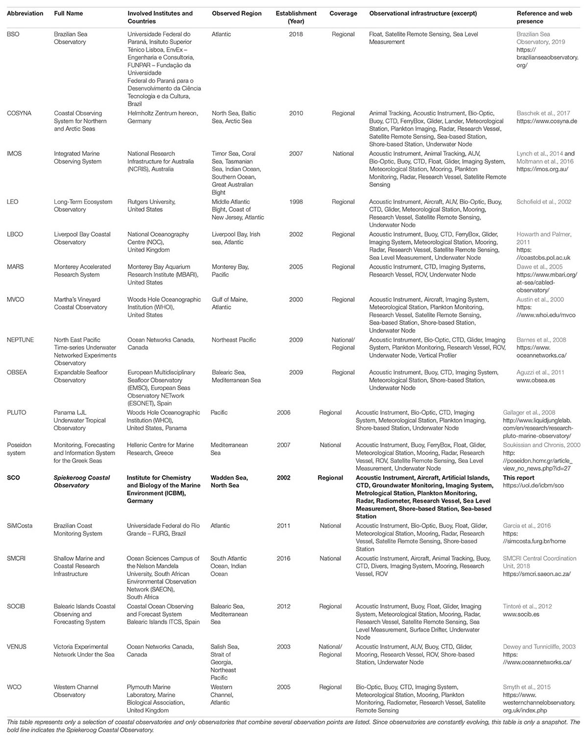
Table 1. Selection of coastal observatories and collaborating observational sites in alphabetical order.
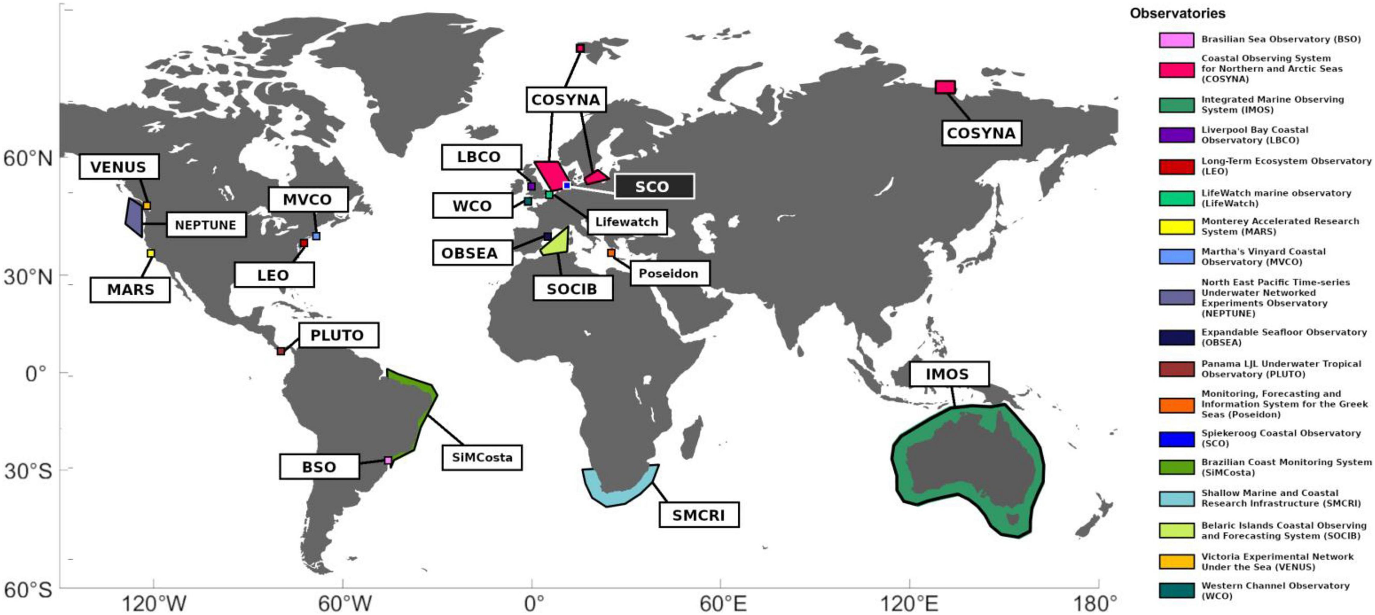
Figure 1. Overview coastal observatories. This map displays a variety of coastal observatories on different spatial and political scales. The observatories are color-coded and their abbreviations are explained within the legend.
Even though most of the observatories listed in Table 1 are located adjacent to the coast, the range of operating and measuring depth ranges from a few meters to more than 2500 m. In some cases, the observatories are located on coastal lines with a steep continental slope (POSEIDON, NEPTUNE). Some observatories consist of multiple, interdisciplinary sites with various, partly autonomous platforms on land, in the sea, and in the atmosphere (SMCRI, LifeWatch Belgium, IMOS, BSO, LEO, LBCO, etc.). Other observatories have a cabled structure (MARS, VENUS, OBSEA, MVCO, etc.), where a node at the sea floor is connected to multiple other nodes with sensor systems for different marine parameters. All ocean observatories include acoustic systems (like an ADCP) and measurement systems for physical oceanography parameters (e.g., temperature and salinity). In addition, biological, chemical, and meteorological measurements are common as well as remote sensing. Only a few observatories include further land-based sensors, e.g., radar stations (SOCIB, MVCO, COSYNA, etc.). Some also include GPS-tracking of animals (COSYNA, SMCRI, IMOS). In order to achieve a detailed overview of the observed region, data collected from the individual measuring points of an observatory are integrated into databases. Often, collected data is being contributed to superordinate institutions, which can be part of the GRAs. Supplementary 1 provides a short analysis about identifiable equipment characteristics among the different observatories.
Spiekeroog Coastal Observatory
The Spiekeroog Coastal Observatory (SCO) is an integrated coastal observatory located on and around the barrier island Spiekeroog in the German southern North Sea. It is operated by the Institute for Chemistry and Biology of the Marine Environment (ICBM, University of Oldenburg) (Figure 2). The SCO consists of various technical infrastructure and concomitant research activities that developed around it, representing a combination of long-term exploration sites as well as campaign-based research sites (Figure 3). Its overall objective is to obtain a comprehensive, interdisciplinary investigation of terrestrial and marine processes around Spiekeroog. Thereby, the SCO indicates a unique characteristic in interdisciplinary element sites operated in the Wadden Sea, the largest tidal flat region worldwide.
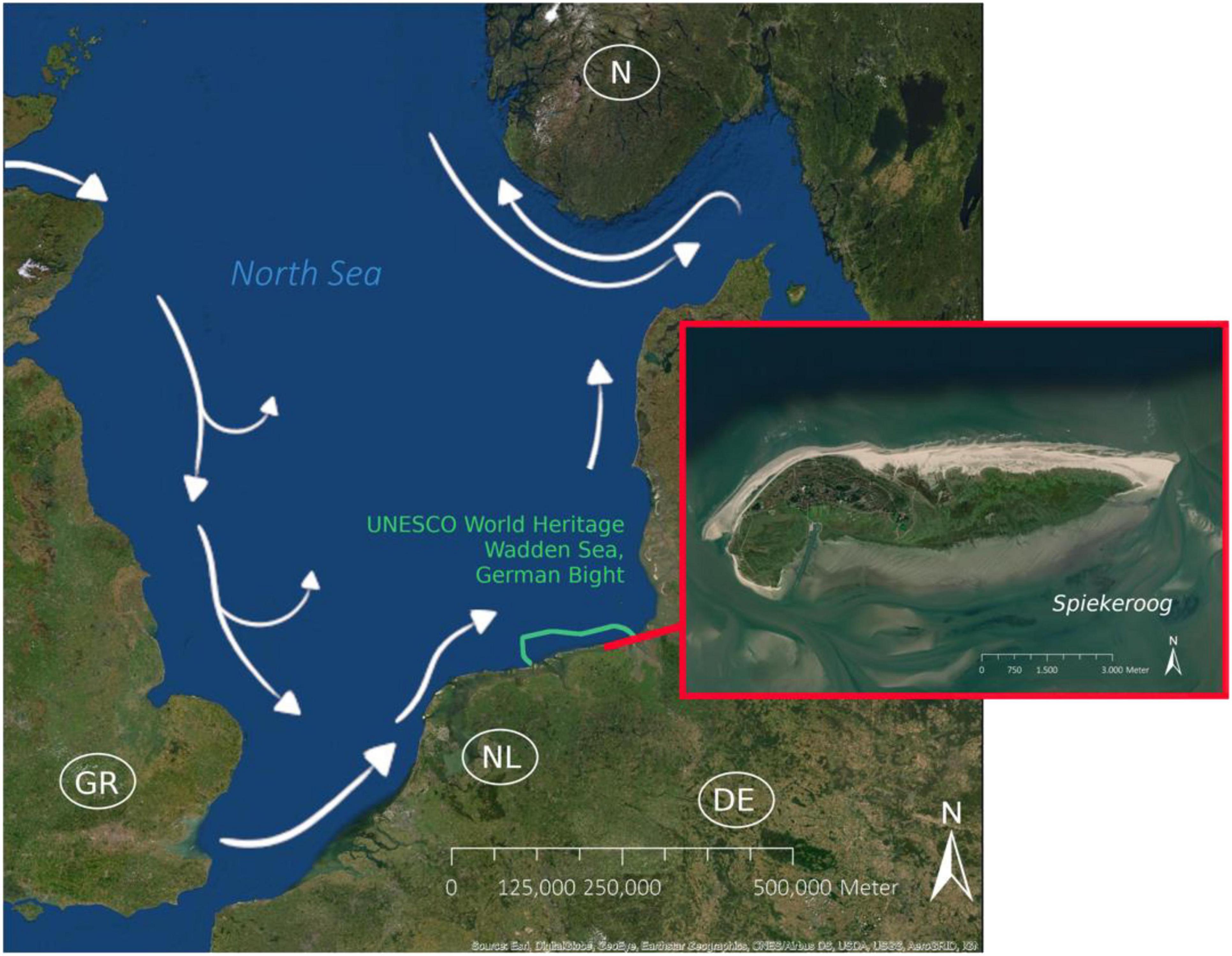
Figure 2. North Sea/Spiekeroog. The island of Spiekeroog (53.77°N, 7.73°E) is located in the German Bight (southern North Sea). The North Sea is a marginal sea connected with the Atlantic Ocean via the Norwegian Sea and the English Channel. Entering from the Atlantic, a Kelvin wave created by tidal effects runs southward primarily along the British east coast and synchronizes with the tides running in via the English Channel and the river run-offs. This induces a counter-clockwise current regime in the North Sea, with a west-to-east flow is forced within the southern North Sea that is fueled by strong westerly winds (Mathis et al., 2015). This primary direction of flow is almost continuous and rarely interrupted by regional weather phenomena (Stanev et al., 2019). Spiekeroogs back-barrier tidal flat is part of the German East Frisian Wadden Sea, renowned as UNESCO World Heritage Site.
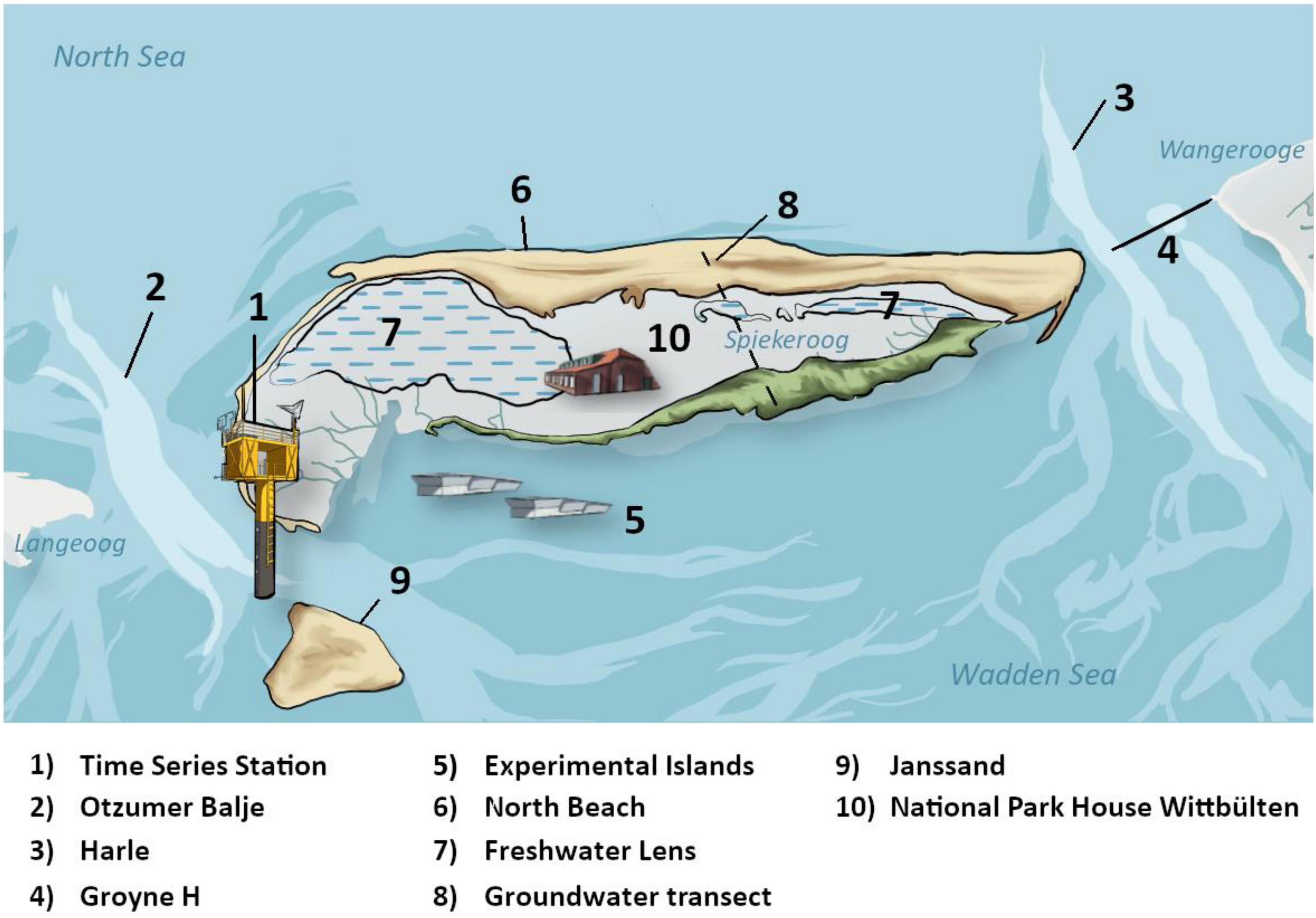
Figure 3. SCO Study sites. The Spiekeroog Coastal Observatory (SCO) represents a combination of long-term exploration sites (1, 5, 7, 8) as well as campaign-based research sites (2, 3, 4, 6, 9). (1) The Time-Series Station Spiekeroog is continuously recording oceanographic, meteorological, and biogeochemical data since 2002. (5) Experimental islands and salt marsh enclosed plots were established in 2014 exploring interactions of plants and animals within a metacommunity framework. Abiotic and biotic data is observed since the set-up. (8) A long-term groundwater monitoring transect was installed in north-south direction at the western part of the Ostplate in 2016 investigating the simultaneous evolution of dunes and accompanying freshwater lenses (7). Both, the North Beach (6) and the Janssand (9) serve as campaign-based research sites since 2014 and respectively 2002. (10) A modern research center was established in 2011 on Spiekeroog providing laboratory, training rooms, and accommodations for scientists. The Gute Küste Niedersachsen project is a good example, successfully using many different components of the SCO. It combines research at different sites around and on the island and will conduct research campaigns at the tidal channels Otzumer Balje (2) and Harle (3) with special consideration of the artificial coastal protection measure Groyne H (4).
The basis for the SCO was established in 2002 with the construction of the Time-Series Station (TSS) Spiekeroog (Reuter et al., 2009), a monopole structure in the tidal channel Otzumer Balje (chapter 2.2.1), west of Spiekeroog. It bundled preceding research initiatives and grew continuously to the present observational infrastructure covering a multitude of parameters. In 2010, the SCO became a part of the COSYNA network (Baschek et al., 2017). It was officially registered as one site within the German Long-Term Environmental Research Network in 2018 (LTER-D, Mirtl et al., 2018). From the beginning, a special focus was research on the Wadden Sea. Thus, a unique characteristic of the SCO is the interdisciplinarity of its elements, which is necessary to study this area comprehensively from different perspectives. For this reason, the SCO contains not only terrestrial and marine components, but also subsurface research infrastructure at the transition zone between land and sea. The term SCO has been coined in 2018. The detailed description of methodologies, concepts, and underlying science presented here is intended to be a potential blueprint for observing systems in coastal areas.
General Location
Spiekeroog is a typical barrier island sheltering the German Coast as one of the seven East Frisian Islands. The island is located within Wadden Sea UNESCO World Natural Heritage site in the German Bight (southern North Sea, Figure 2). With average deep-wave heights exceeding 1.0 m (Fitzgerald et al., 1984) and a mean tidal range about 2.7 m (Zielinski et al., 2018), the area is highly dynamic. Thus, the area is strongly affected by erosion and sedimentation, mainly directed through the tidal inlets. These narrow channels between the barrier islands exchange North Sea and Wadden Sea water along a northwesterly axis. As for Spiekeroog, the channel at its western part is the Otzumer Balje, the one in the east is referred to as Harle. The maximum tidal current velocities within these tidal inlets reach 1–1.5 m/s (Stanev et al., 2003) mobilizing a wide range of suspended material that oscillates in the vicinity of Spiekeroog (Badewien et al., 2009). A tidal asymmetry surrounding the area due to tidal pressure gradients and inlet morphology (Hayes, 1980) leads to an unbalanced supply of those sediment depots to the island. Additionally, severe storms and storm surges cause significant mass transports within short periods.
The island extends approximately 10 km from east to west and 2 km from north to south, with a total area of 21.3 km2. The back-barrier tidal flat south of Spiekeroog is part of the German East Frisian Wadden Sea. Dunes along the northern shoreline of Spiekeroog form almost a continuous arc (maximum height 11 m) along the west-east direction. They are sheltering an extensive salt marsh area and acting as a natural protection for the inhabited parts of the island (Röper et al., 2013). In the east, sediment accretion has led to the development of the so-called Ostplate. It originated from a periodically flooded sand flat to a dune island in the 1940s, with the first higher white appearing in the 1970s (Röper et al., 2013). The western part of the island is prone to land loss from mass transport (Röper et al., 2012).
Study Sites and Spiekeroog Coastal Observatory Elements
The Spiekeroog Coastal Observatory consists of several (technical) elements (Figure 4) integrated in different study sites (Figure 3). This includes the Time-Series Station (TSS) Spiekeroog, a permanent monitoring station in a tidal channel west of Spiekeroog, a number of research boats, experimental islands within the back-barrier tidal flats south of Spiekeroog, as well as a groundwater monitoring network. In addition, several other study sites are available on the island serving as campaign-based research sites. Science communication, knowledge transfer and public outreach represent a further element of the SCO. All study sites and elements of the SCO are described in this section in further detail.
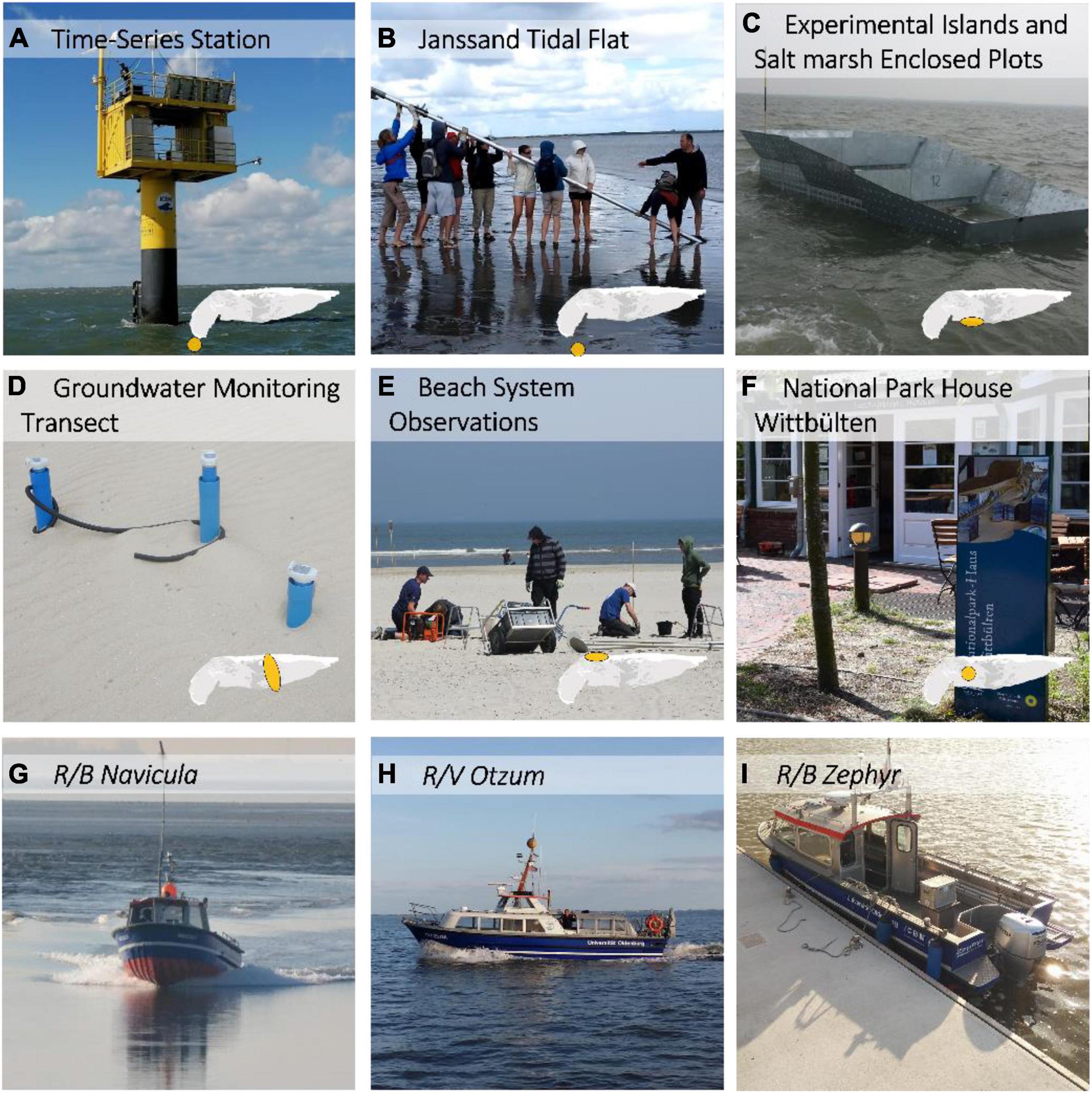
Figure 4. SCO infrastructure and elements. Several components are available supporting the Spiekeroog Coastal Observatory. The ICBM operates the Time-Series Station Spiekeroog, a permanent monitoring station southwest of Spiekeroog (A). The Janssand (B) and North Beach (E) serve as campaign-based research sites for biogeochemical observations. Experimental islands were built within the back barrier tidal flats and corresponding salt marsh enclosed plots in the South for metacommunity and biodiversity research (C). Dip wells were installed on a transect for groundwater monitoring (D). As an accommodation for scientists as well as a communications platform serves the National Park House Wittbülten (F). Three different research boats are available supporting any kind of research activities of the SCO (G–I).
Tidal Channels and Marine Infrastructure
The interexchange of seawater between the southern North Sea and the back-barrier tidal flats of Spiekeroog takes place through two tidal channels: The Otzumer Balje in the West between the islands of Langeoog and Spiekeroog and the Harle in the East between Spiekeroog and Wangerooge (Figure 3).
Compared to the Harle, the Otzumer Balje is a pristine tidal channel affected by minimal human intervention. Its current dynamics have been well studied as it is the location of the Time-Series Station Spiekeroog (see below), which is one of the major SCO elements. Generally, the Otzumer Balje is characterized by a small tidal range that results in greater inlet spacing, deeper channels, an ebb-dominance during calm weather conditions, and low marsh elevation heights (Friedrichs and Perry, 2001). During storm surges in the back-barrier system of Spiekeroog, the ebb-dominance can temporarily be neutralized or reversed in a flood-dominated situation (Stanev et al., 2007; Bartholomä et al., 2009).
The Harle is more impacted by anthropogenic intervention in the form of coastal protection measures. To stabilize the beach of the island Wangerooge, sediment dynamics and tidal current characteristics were altered by the installation of several groins in the late 19th century, which are maintained and refurbished until today. Groyne H is especially prominent, as it reaches into the Harle tidal channel with a length of 1460 m (Lüders, 1952; Ladage and Stephan, 2004). However, the processes leading to its island stabilization effect are surprisingly poorly investigated. Thus, in order to understand the current dynamics along such a large structure in more detail, a comparison of the two tidal channels of Spiekeroog is a focus of current research in the context of the project Gute Küste Niedersachsen (see section “Real-World Laoratories for Ecosystem-Strengthening Coastal Protection”). Further, we assess the influence of such coastal protection measures on the wider marine ecosystem.
Time-Series Station Spiekeroog
To deepen the understanding of complex relationships in the Wadden Sea ecosystem, the Time-Series Station Spiekeroog (Figure 4A) has been installed as a permanent measuring station in the Otzumer Balje (53.75°N, 7.67°E) at a mean sea level of 13 m (Figure 5). The TSS was constructed in the framework of the Deutsche Forschungsgemeinschaft (DFG) research group BioGeoChemistry of Tidal Flats in 2002 (Reuter et al., 2009; Rullkötter, 2009). Understanding the underlying processes is crucial for predicting the consequences of storm surges or the currently recorded sea-level rise in the Wadden Sea (NLWKN, 2010) as well as supporting appropriate coastal protection measures. In this context, the TSS is now an indispensable tool for Wadden Sea-related research at the ICBM (Bartholomä et al., 2009; Lettmann et al., 2009; Burchard and Badewien, 2015; Grashorn et al., 2015; Valle-Levinson et al., 2018).

Figure 5. Time-series station. Schematic figure of the Time-Series Station Spiekeroog. NN is defined at 13.0 m with slack water rising and sinking about 1.5 m. The waves may approach 20.5 m of height. The main body of the station contains the data management and batteries. The latter forms the power supply for the structure in combination with a solar panel and wind propulsion at 25 m. Sensors are applied to cylindrical tubes, which are deployed within the pole (M-D) below water. Tubes without depth markers remain closed while tubes with labels stay open enabling water to flow through with the sensors measuring designated parameters (D – temperature, conductivity, pressure | F, H, J – temperature, conductivity | K – temperature, conductivity, nutrients | M – oxygen, turbidity). The widget at level M is an additional sensor installed at the outside of the pole. At 1.0 m above the seafloor, an Acoustic Doppler Current Profiler (ADCP) is mounted perpendicular to the pole via a rod.
Oceanographic, meteorological, and biogeochemical data have been continuously recorded since 2002 at the TSS. The station consists of a 35.5 m long pole with a diameter of 1.6 m that is driven 13.6 m into the sediment (Figure 5). The temperature, conductivity, and pressure sensors are mounted within five horizontal tubes (1.5, 3.5, 5.5, 7.5, and 9 m above seafloor, respectively) that are aligned in the main current direction. These tubes protect the sensors, which makes the TSS capable of being operational also during storm events and ice conditions. An acoustic Doppler current profiler (ADCP) is mounted 1.5 m above the seafloor on a horizontal arm of 12 m length. A platform is mounted on top of the pole, about 7 m above sea level. It consists of two laboratory containers (L × W × H: 3.0 m × 1.2 m × 2.3 m) hosting a second platform at 12 m above sea level equipped with solar panels, a wind turbine, and meteorological sensors. A set of radiometers is mounted to this platform, measuring incident solar radiation and light that emerges from the sea surface in order to derive some apparent optical properties of the water (Garaba et al., 2014). For further details and design considerations see Reuter et al. (2009). Furthermore, two online nutrient analyzers (Systea S.p.A., Italy) measuring, e.g., NO3–, NO2–, Si–, and PO43– are installed inside the pole, receiving their water samples from a sensor-tube mounted 9 m above seafloor. These instruments facilitate the understanding of nutrient input and consumption under different tidal conditions by providing year-round regular measurements (Grunwald et al., 2007, 2010). The oceanographic data obtained by the TSS allowed for a large number of process studies in the highly dynamic tidal areas in recent years, addressing topics such as water level changes and storm surges (Holinde et al., 2015) or water transparency (Schulz et al., 2016).
The TSS long-term data is further a very important basis to validate hydrodynamic and sediment transport models in coastal areas of the East Frisian Islands (Burchard et al., 2008; Badewien et al., 2009; Lettmann et al., 2009; Staneva et al., 2009; Gao et al., 2012; Grashorn et al., 2015; Gräwe et al., 2016). To exhibit example data available through long-term operation of the TSS, Figure 6 shows a time series plot for air (A) and water (B) temperature measurements during the past two decades. Raw data is shown compared to a moving monthly average and monthly mean values for both measurements, while Figure 6C shows the monthly means of air and water temperature.
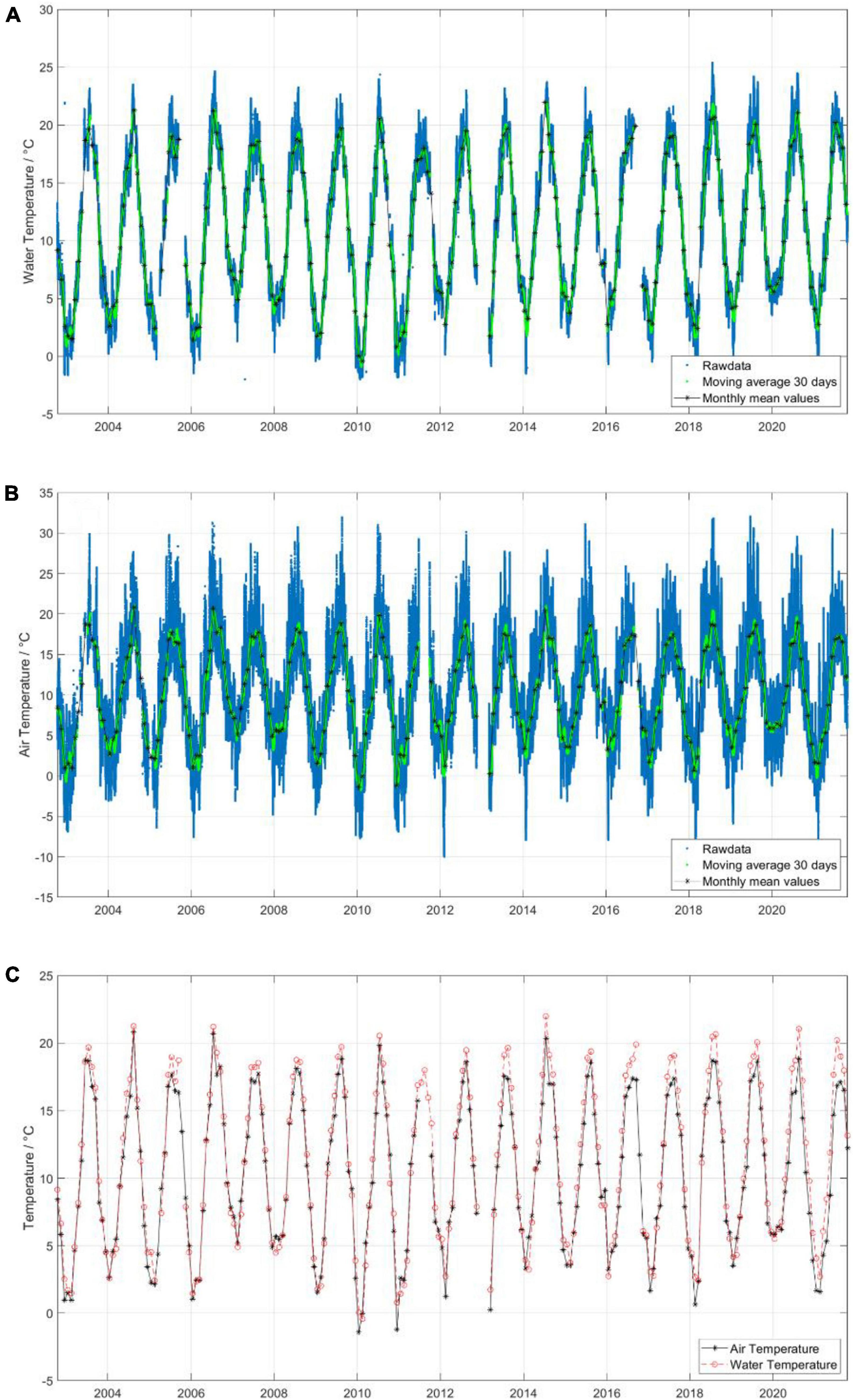
Figure 6. Temperature time series measurements. Time series plots from the Time-Series Station Spiekeroog showing air and water temperature from 2002 until late 2021. (A) Displays the raw water surface temperature, measured in tube K (Figure 5), a moving average of 30 days and monthly mean values. (B) Displays the raw air temperature, a moving average of 30 days and monthly mean values. (C) Shows the monthly mean values of air and water temperature.
The integration of the SCO in the framework of COSYNA (Baschek et al., 2017) made it possible to refurbish the TSS sensor technology. This extended the service life of the station and set the basis for the successive addition of new components. In 2019, a conventional marine X-Band radar was installed, providing 3D wave and surface current data (Bell and Osler, 2011), enabling also the survey of the study site in this respect. Upcoming additions will be sensors for the measurement of total alkalinity, pH, carbon dioxide, and precipitation in order to investigate processes related to the carbon cycle of the Wadden Sea. Further potential upgrades currently under consideration include a nutrient auto-sampler as well as an in situ submersible UV-photometer for high resolution optical nitrate determination. In addition to the usage of commercially available instruments and devices, also new sensors and sensor systems have been successfully tested under extreme conditions on the TSS (e.g., Rüssmeier et al., 2017).
Research Vessels
Three small research vessels (R/B Navicula, R/V Otzum, and R/B Zephyr; Figure 4) are also part of the SCO infrastructure. Varying in size and personal capacity (Table 2), they support different activities in the observatory, e.g., maintenance of the TSS, diver operations, sampling, or even small measurement campaigns. For this, all ships provide a certain number of sheltered workplaces including power supply for instruments as well as moon-pools that allow easy deployment of submersible instruments like an ADCP. R/V Otzum further possesses a crane for operating CTD rosette samplers or other larger instruments.
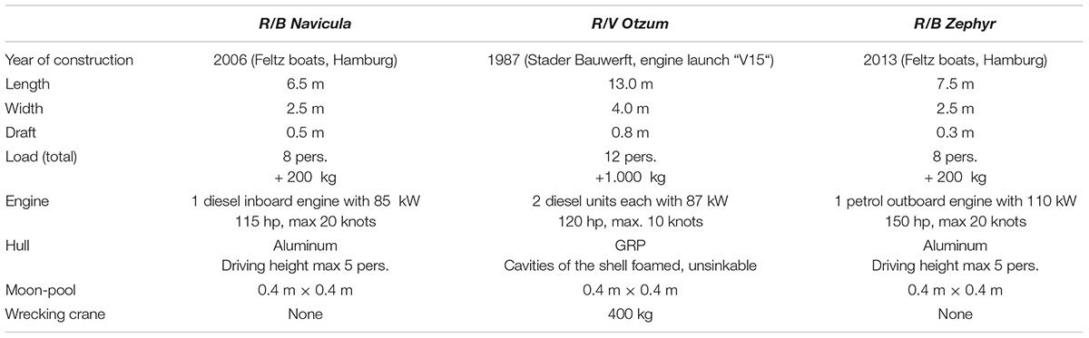
Table 2. Technical specifications of R/B Navicula, R/V Otzum, and R/B Zephyr.
Back-Barrier Tidal Flats and the Janssand
The back-barrier tidal flats of Spiekeroog are typical for the East Frisian Islands and predominantly sandy (Liebezeit et al., 1998). The Janssand is a tidal flat located in the back-barrier tidal flat area south-west of Spiekeroog (Figure 3). It represents a focus area for tidal flat research in the SCO. It is characterized by mesotidal conditions, thus covered by 1–2 m of water during high tide and being exposed for approximately 4–6 h during low tide (Beck et al., 2007). The surface of Janssand is almost horizontal, except for the margin where the sediment surface slopes toward the main tidal creek by an altitude of 1.5 m. Sandy sediments predominate the upper sediment column and are increasingly intermingled with thin clay horizons in deeper layers and occasional peat inclusions (Chang et al., 2006). The sand body is characterized by a tidally driven water exchange. Advective processes lead to a recharge of nutrients during high tide into the sediments (Riedel et al., 2010) and a discharge of microbial mineralization products (i.e., nutrients, hydrogen sulfide, methane, and reduced redox elements) during ebbtide into the open North Sea (Røy et al., 2008). This hydrogeological flow regime has an impact on the vertical distribution of microbial communities within the sediments (Seidel et al., 2012). The vertical zonation of geochemical profiles and associated microbial communities (Wilms et al., 2007) varies with distance to the main tidal creek (Beck et al., 2009). Due to the enhanced nutrient supply by discharging porewater and deposition of fresh organic material at the tidal flat margin, the microbial activity is vastly stimulated. This causes a highly condensed succession of redox-sensitive elements within the upper meter of the sediment column. With increasing distance to the creek, these biogeochemical profiles are stretched over the upper 5–6 meters of sediment, indicating areas of varying microbial activities in close proximity. In the middle of the sand flat, microbial activities are so low that the profiles can even stretch tens of meters into the subsurface as identified by a deep drilling campaign on Janssand (Beck et al., 2011). Overall, the described biogeochemical processes turn the tidal flat into an effective bioreactor. The metabolic transformations lead to the discharge of nutrients into the Wadden Sea, enhancing the primary production within the system.
Biogeochemical Findings on Janssand Tidal Flat
Due to the good accessibility by boat, the long exposure time during low tide, and the relatively solid surface, Janssand became a model research area in the DFG research group BioGeoChemistry of Tidal Flats (Rullkötter, 2009). Intense interdisciplinary investigations over the past two decades made Janssand the best-studied sand flat in the world. This is documented in more than 90 peer-reviewed publications in international journals, several Ph.D. theses, and numerous Bachelor’s and Master’s theses. A striking feature for analyzing deep porewater processes within the subsurface of Janssand throughout different seasons or even tidal cycles was the installation of permanent in situ porewater samplers (down to 5 m; Beck et al., 2007, 2008a,2008b). These studies show seasonal variations of sulfate, dissolved organic carbon (DOC), nutrients and metabolic products down to 5 m sediment depth in the pore waters. In the study area, pore water temperatures show significant variability in the upper meters of the sediment within 1 year (higher temperatures in summer, lower temperatures in winter). Hydrolysis rates and activities of fermentative microorganisms are enhanced at higher temperatures resulting in higher concentrations of metabolizable organic carbon in summer months. The close proximity to the Time-Series Station was used to link pelagic processes to those found within the sediments (Dellwig et al., 2007). Even though the research group officially ended in 2009, more than 50 publications emerged from the scientific work carried out in this area since then. Janssand is still an active study area, e.g., for advanced study courses of the German Universities of Oldenburg and Bremen (Figure 4B).
Natural Salt Marshes and Experimental Islands With Salt Marsh Enclosed Plots
Typical for barrier islands (thus also for Spiekeroog) is the natural development of salt marshes on the side protected from the open North Sea. Salt marshes play an important role in coastal engineering and protection measures due to their ability to trap suspended sediments and attenuate waves (Möller et al., 2014). Resilient salt marsh ecosystems can therefore mitigate the effects of climate change. Changes in tidal range resulting from sea level rise and climate change, but also extreme events like storm surges exceeding levels beyond those of the typical storm season can lead to salt marsh loss.
The intertidal zone with its salt marshes has accordingly gained increasing attention with respect to exploitation of the ecosystem services they provide while simultaneously ensuring their adequate protection (Kirwan and Megonigal, 2013; Balke et al., 2016). The seaward limit of a salt marsh is generally defined by the lowest elevation where vascular plants (e.g., Spartina spp.) can establish (Balke et al., 2016). Low wave energy and high resistance salt marsh vegetation often lead to the development of sharp vegetation edges whereas exposure to high wave energy conditions homogeneously erode the salt marsh edges (Leonardi and Fagherazzi, 2014). Elevation levels of salt marshes determine the inundation duration and frequency, which are essential parameters shaping the local salt marsh conditions (Balke et al., 2016). European salt marshes have developed a distinct zonation of vegetation along elevational gradients. Three natural salt marsh zones can be identified on the salt marshes of Spiekeroog (Holt et al., 2017): pioneer zone [1.5 m NHN, normal height null, dominated by Spartina anglica (C.E. Hubbard)], lower salt marsh zone [1.8 m NHN, dominated by Atriplex portulacoides (L.)], and upper salt marsh zone [2.1 m NHN, dominated by Elymus athericus (Kerguélen)]. Plant communities characterizing the zones are in general relatively species poor.
Experimental Islands and Salt Marsh Enclosed Plots
Exploring interactions of plants and animals within a metacommunity framework often requires long-term approaches. A large-scale experiment within the back-barrier tidal flats of Spiekeroog was set-up in 2014 (Balke et al., 2017; Figure 3). It serves as a test of metacommunity theory predictions across the marine and terrestrial interfaces. The setup (Figure 4C), on the tidal mudflats represent the dispersal-limited conditions and the corresponding salt marsh enclosed plots with unlimited rapid dispersal. Each of the experimental islands is a replicate with three elevation levels. Each level has the same elevation as the corresponding vegetation zones of the nearby salt marsh: pioneer, lower and upper salt marsh zone. Half of the experimental islands and salt marsh plots were inoculated with lower salt marsh communities from the nearby salt marsh, while the other half of the study plots were filled with untreated mud flat sediment available for spontaneous colonization. Six reference plots in each salt marsh zone serve as an undisturbed control. This setup enables the investigation of priority effects, i.e., the effect of already present species on the arrival of new species. Species abundances have been recorded since the installation of the experiment in 2014. After 1 year, colonization of plant species with high fecundity was observed on all bare plots. As expected, frequency was higher within the salt marsh bare plots (Balke et al., 2017). Competitive exclusion on higher elevations affected community composition already 2 years after transplanting the communities (unpublished data). After 4 years of community composition competitive exclusion on most of the transplanted plots were observed and the communities resembled the ones of natural salt marshes (unpublished data).
Long-term approaches for biodiversity research also require the continuous observation of environmental key parameters. Those were assessed from sensors deployed around and within the experimental plots since 2014. Data show seasonal and tidal effects on both, experimental islands and salt marsh enclosed plots, and reveal the impact of, e.g., storm surges and hot spells (Zielinski et al., 2018). Since 2020, a mobile field container in the vicinity of the salt marsh supports the fieldwork of the large-scale experiment. It serves as storage space, preparation site, and allows access for near-real-time data of meteorological conditions on site via internet connection.
Soils and Dune Vegetation
The eulittoral sandy beach of Spiekeroog experiences a constant redistribution of sands by continuous current and wave actions, resulting in soils persisting in initial formation stages. Likewise, the supralittoral beach soils also persist in initial formation stages due to sand movement induced by wind and episodic flooding (Pollmann et al., 2018). Except for shallow embryo dunes at the supralittoral beach, the epilittoral dunes of Spiekeroog are locally referred to as white dunes (Weißdünen), gray dunes (Graudünen), and brown dunes (Braundünen), which evolve over time in this order (Sindowski, 1970). These different types of dunes form a dune complex in the western part of Spiekeroog, which allows the study of soil chronosequences (Gerlach, 1993; Gerlach et al., 1994; Giani and Buhmann, 2004; Pollmann et al., 2020). The white dune soils are covered with Ammophila arenaria and are affected by deflation and sedimentation prohibiting the formation of more complex soils. They comprise quartz-rich (≈ 95 wt%) and carbonate-poor (<1 wt%) sandy parent material and lack soil organic matter (SOM) enriched topsoil horizons (Pollmann et al., 2018, 2020). On the gray dunes, plant biodiversity increases (Isermann, 2011), denser vegetation cover stabilizes the ground surface, and wind-induced sand movement decreases. Further advanced soil formation stages are reflected by the formation of a topsoil horizon enriched with SOM and initial decarbonization and acidification (Pollmann et al., 2020). The brown dunes exhibit a vegetation zonation mainly due to slope aspect-related microclimates (Gerlach et al., 1994; Isermann, 2011). While north-facing slopes are predominantly covered with Empetrum nigrum and Polypodium vulgare, south-facing slopes are covered mainly with Corynephorus canescens, and moss and lichen species. Fulvic acids particularly originating from the poorly decomposable litter of Empetrum nigrum initiate podsolization in the braunified and strongly acidic [pH (CaCl2) < 4] soils (Pollmann et al., 2018, 2020). Pollmann et al. (2020) found incipient podsolization features in a brown dune soil of Spiekeroog after a soil formation time of maximal 179 ± 17 years. The soils of the south-facing slopes, in contrast, show a lesser extent of podsolization and braunification (Pollmann et al., 2020). Near-groundwater dune slacks often hold soils with a superficial peat layer (Pollmann et al., 2018).
Via periodic flooding, fine-grained sediments (clay, loam) enter the salt marsh of the Ostplate and build up deposits on top of a basal sand flat. Therefore, the carbonate containing and neutral to slightly alkaline salt marsh soils are usually comprised of a two-layered or even multiple-layered solum (Pollmann et al., 2018, 2021). Pollmann et al. (2021) showed, by means of carbon isotope (δ13C) signatures of organic matter (OM) in fine-grained salt marsh deposits, an increase of the proportion of allochthonous marine organic matter (OM) with increasing flooding frequency in the salt marsh of the Ostplate. Their results also indicate that erosion and sedimentation induced by tides might potentially reset soil formation stages of the salt marsh soils.
Freshwater Lens and the Groundwater Transect
The average annual precipitation on Spiekeroog is 808 mm (Oldenburg-Ostfriesischer Wasserverband [OOWV], 2012). Groundwater recharge takes place in the permeable dune areas and feeds a so-called freshwater lens at the western part of the island, providing drinking water to the islands’ population (Röper et al., 2012). The freshwater resides in an upper aquifer made of sand deposits from the Pliocene, Pleistocene, and Holocene, underlain by a clay layer, restricting the thickness of the freshwater lens to 45–50 m. The aquifer below the clay is saline (Oldenburg-Ostfriesischer Wasserverband [OOWV], 2009). An annual groundwater recharge rate of 300–400 mm was calculated using tritium-helium data, and the age of the groundwater was found to increase with depth to >70 years at the freshwater-saltwater interface (Röper et al., 2012). Seibert et al. (2018) investigated the hydro-chemical evolution – from recharge to discharge – of freshwater. They found that cation exchange, calcite dissolution, and redox reactions are the main biogeochemical processes occurring in the freshwater lens. The groundwater is reducing and even sulfidic at greater depths. Seibert et al. (2019) further modeled hydro-biogeochemical processes, such as microbial sulfate reduction and subsequent iron sulfide precipitation. They also showed that the groundwater becomes progressively enriched in ammonium and phosphate due to organic matter remineralization. Reckhardt et al. (2021) recently linked the behavior of redox-sensitive metals to groundwater age and redox characteristics within the freshwater lens. Based on ground-based handheld thermal infrared imagery data, either diffusive or punctual freshwater discharges at the northwestern beach have been observed (Röper et al., 2014). Hence, lens-derived nutrient fluxes could be of relevance for the beach ecosystem as well as the coastal ocean.
Groundwater Transect on the Ostplate
A long-term groundwater monitoring transect was established in north-south direction at the western part of the Ostplate (Figure 3) in March 2016 in the course of a DFG project investigating the simultaneous evolution of dunes and accompanying freshwater lenses. The transect is oriented parallel to the main groundwater flow direction following the general topography. Multilevel observation wells (Figure 4D) equipped with data loggers were installed in different depths (meter above sea level) at the beach (approx. 0.8, −5.3, and −12.7 m), the northern part of the dune ridge (approx. 1.5, −1.5, −4.6, and −6.4 m), and the southern part of the dune ridge (approx. 1.7, −1.0, and −3.1 m). Three shallow single data loggers were placed within the salt marsh south of the dunes, screening near-surface groundwater at 1.29, 1.34, and 0.97 m. The wells along the transect were sampled over 1.5 years using submersible pumps for hydro-chemical analysis. They were further used to study the extend of the freshwater lens and the interplay of inundation frequency, shallow groundwater salinity, and vegetation (Holt et al., 2017), subsequently relating hydro-geochemical patterns in the near-surface groundwater (Seibert et al., 2021). Furthermore, variable-density flow and transport modeling were conducted to simulate the evolution of the freshwater lens over the past decades including its age distribution (Holt et al., 2019, 2021). Seibert et al. (2019) used the sites to investigate sedimentation rates and iron sulfide formation at the land-sea transition. Though the wells are presently not sampled regularly for chemical analysis, groundwater levels and partly electrical conductivities continue to be measured in 10-min intervals using CTD and pressure sensors.
Sandy Beach System and BioGeoChemical Observations
Dunes and a sandy, high-energy, meso-tidal beach system characterize the northern shores of Spiekeroog. The North Beach is composed of fine to medium-grained Holocene sands above Pleistocene deposits (Seibert et al., 2018). Depending on weather conditions, wave heights and energy vary a lot generating a highly dynamic beach morphology with a ridge-runnel system parallel to the shoreline (Dobrynin et al., 2010; Beck et al., 2017; Kröncke et al., 2018). The ridge-runnel-system migrates in both parallel- and cross-shore directions on time scales as short as days, causing changes in local beach elevation of up to 2 m (Waska et al., 2019). Tidal and wave pumping create advective water flows through the intertidal beach zone. Seawater infiltrates in the upper beach at high tide, and exfiltrates into the runnel and at the low water line during low tide. In the beach aquifer, the circulating saline porewater mixes with groundwater from the freshwater lens, producing a so-called subterranean estuary (STE). It has a typical hydrological zonation with an upper saline plume, a freshwater discharge tube, and a saltwater wedge (Beck et al., 2017), whereby the ridge acts as an additional infiltration zone inducing the existence of two, at least temporally occurring, saltwater recirculation cells (Grünenbaum et al., 2020a). With a multi-method approach, Grünenbaum et al. (2020b) quantified in- and exfiltration rates in the intertidal zone and showed that infiltration occurs above mean sea level while net exfiltration occurs below, with exchange rates clearly depending on beach topography. With a transient variable density groundwater flow and transport model Greskowiak and Massmann (2021) demonstrate how transient beach morphology and regular storm floods affect subsurface flow and transport pattern (Figure 7). As a whole, the high-energy beach on Spiekeroog has been termed a microbial biogeochemical reactor, which utilizes electron acceptors and organic matter from the marine and terrestrial endmembers (Reckhardt et al., 2015; Beck et al., 2017).
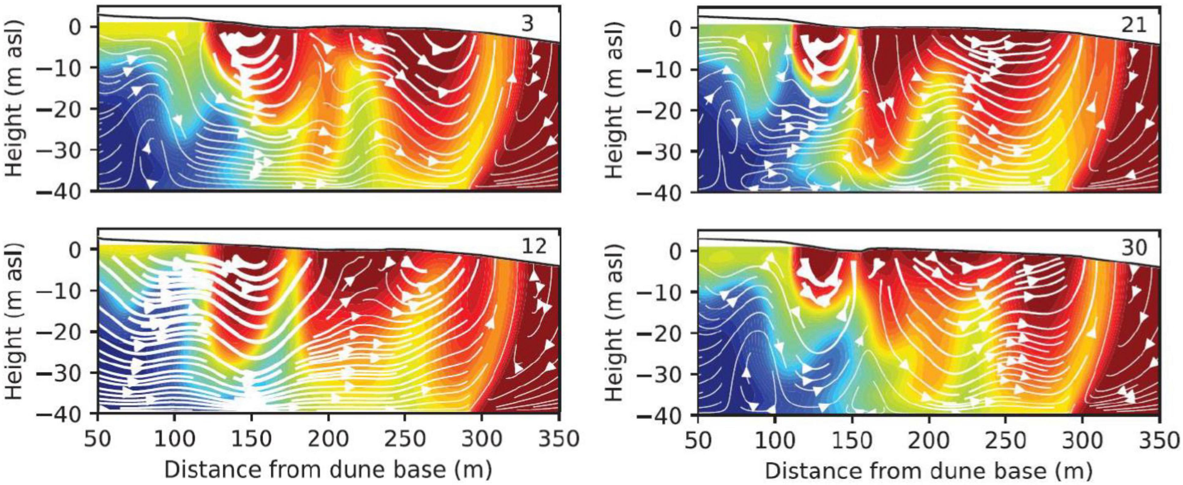
Figure 7. Key findings in the BIME project. Simulated dynamic changes in salinity (red = seawater, blue = freshwater) in the intertidal area of the sandy-beach system on Spiekeroog, and the direction of flow (white arrows), thereby the flow velocity is represented by the thickness of the arrows. The change of the system after 3, 12, 21 months is shown when considering the tide, as well as the change of the topography in the model (modified after Greskowiak and Massmann, 2021).
Biogeochemical Observations of Beach Systems
To deepen the understanding of the subterranean estuary, campaign driven sampling focuses on the seawater infiltration zone and the highly diverse submarine groundwater discharge (SGD) exfiltration zones (Figure 3). Groundwater modifications at sediment-water interfaces as well as at redox and salinity gradients within the coastal aquifer were observed, where fresh and saline groundwater mix. The STE was investigated using a novel combination of perspectives (Figure 4E): hydrological (modeled and measured water fluxes and flow patterns), geochemical (nutrient, trace metal, and dissolved organic matter cycling), and microbial (community patterns and metabolic processes). Further, beach topography and study sites was mapped with a differential GPS (Waska et al., 2019).
Porewater chemistry is investigated by extracting water from stainless steel porewater lancets driven into the sediments to up to 2 m depth. During field campaigns, the following parameters were determined with handheld devices: salinity, temperature, dissolved oxygen, and FDOM fluorescence (λ = 420 nm) (Waska et al., 2019). For hydraulic investigations, groundwater observation wells were installed and equipped with CTD sensors (Grünenbaum et al., 2020a). To investigate sediment properties, sediment cores were collected offshore using an electric underwater vibrocorer and onshore vibrocoring as described by Wilms et al. (2006). Sampled porewater was analyzed for metals (Mn, Fe), nutrients (total sulfur, silica, phosphate, NO3–, NO2–, NH4+, total alkalinity), rare earth element, dissolved organic matter (DOM), DOC as well as temperature, conductivity, dissolved oxygen, colored and fluorescent dissolved organic matter (CDOM and FDOM, respectively).
To measure SGD in situ and with high temporal resolution, an autonomous seepage-meter based on the design of Lee (1977) was developed for the application on high-energy beach systems. A plastic housing (1 m × 1 m) was built with an attached chamber, allowing the in- and exfiltration of water. The chamber is equipped with a multi-channel logger to measure salinity, temperature, pressure, dissolved oxygen, FDOM (λ = 420 nm), pH, and turbidity. To measure the flow rate of the circulating water without mechanical influence, an electromagnetic flow measurement system was chosen. The application time of the seepage-meter depends on the measuring interval and ranges from days to several weeks.
The system is in a constant state of flux due to its location in the intertidal zone and the accompanying influence by tides and the morphological change of the beach profile. This mechanical influence has a direct impact on the STE system, which is in a permanent process of change. It was discovered that microbial communities (with exception of prokaryotes) hardly change within the STE system in the first meter of the intertidal area. The prokaryote communities showed a higher evenness at SGD influenced sites compared to uninfluenced sites. The reason for the low change in species communities, especially in microbial communities, is probably due to the constant physical turnover of the intertidal area by tides and the associated changes in SGD (Degenhardt et al., 2020). This constant influence also plays an important role in other processes with respect to the biogeochemical properties of the STE. Seasons have a high impact on pore water chemistry and microbial communities, on the one hand due to changes in available nutrient concentration but also due to seasonal temperature differences (Ahrens et al., 2020). Furthermore, studies on the age of the pore water in the study area have been conducted. The residence times range from a few days to a few months in the underwater salinity plume, while at the discharge points of the SGD (runnel, low water line) an age of about 21 years has been determined (Grünenbaum et al., 2020a).
Science Communication, Knowledge Transfer, and Public Outreach
Science is an integral part of society development and has to be therefore part of the social consciousness. Science communication, thus the report of research progress and results, is an integral part of this process, ideally actively involving society (knowledge transfer). Environmental education can be a tool in this respect, on the one hand for creating acceptance of science and the potential consequences of its results in society. On the other hand, for enabling meaningful communication about the context being conveyed. Further, environmental education enables people to make responsible decisions with a solid knowledge of the (scientific) background of a topic and the possible consequences of the decision. Thus, in addition to its role as observatory, the SCO fosters also science communication and the dialog with the general public, e.g., through the activities of the National Park House Wittbülten (a research facility directly on Spiekeroog, see below) or via the realization of citizen science projects (e.g., Kopf et al., 2015; Ceccaroni et al., 2020). Being part of the University of Oldenburg, the SCO and its infrastructure serves also as an educational platform for the next generation of marine researchers. The SCO provides the framework for summer schools, and many courses at both the University of Oldenburg as well as at the Jade University of Applied Sciences in Wilhelmshaven are linked to the SCO and benefit from its infrastructure and projects. The close vicinity to their research objects and the possibility of practical work creates a special awareness among the students that is hardly established by solely laboratory or seminar room work.
The SCO knowledge transfer efforts are strongly supported by the Biology Didactics group at the University of Oldenburg, which addresses topics like coastal research, environmental protection, and climate change. With their help, students of biology and (marine) environmental sciences develop environmental education programs in their courses or theses. Subsequently, these programs are implemented in the activities of the National Park House Wittbülten to reach the respective target audiences (pupils, students, teachers, or tourists). A specific example is the regular organization of 1-week internships on Spiekeroog in the context of the Wadden Sea Learning Laboratory5. Here, pupils from surrounding schools are invited to learn about marine research in general and specifically Wadden Sea-related topics according to the concept of research-discovery learning (Schmidkunz, 2003; Mayer and Ziemek, 2006). ICBM scientists contribute content and current research topics, while their didactical arrangement is set up by the university students. By this, the students have the opportunity to test and reflect their didactical skills on marine topics directly on-site.
As Spiekeroog attracts in particular guests with a high interest in nature and nature conservation, the SCO activities and infrastructures offer unique opportunities for engaging locals and tourists by making research perceptible and giving them the opportunity to explore their home or holiday destination from a new perspective. The circumstance of being in the habitat studied, of being part of it, enables a particularly close experience and raise awareness for the research object. This explains the generally high interest on Spiekeroog in the ongoing research, but also in the scientists themselves. This curiosity can be exploited for public outreach, for example by organizing event days on the beach (as planned in the framework of the DynaDeep research group, see section Beach Research), where interested people can discuss with scientists and see sampling equipment. However, in addition to spread knowledge into the society, SCO science communication is also important in the context explaining the ongoing research in order to create acceptance among the local people, especially in cases of larger field campaigns and the installation of research infrastructure. Here, the cooperation with the local newspaper Inselbote is of great value to announce such actions in advance and to report regularly from the research projects.
In all formats of science communication, the cross-media approach is pursued, and synergies are created by utilizing created media on different platforms: on websites, in exhibitions, lectures, within special public events and for social media channels. The cross-media communication of measurement campaigns, the process of knowledge generation and research results will additionally promote the acceptance of scientific work on the island and increase attention for the SCO.
Further opportunities for the communication of SCO research arise from the integration of ICBM public outreach into local and national networks and cooperation projects. The ICBM memberships in the German Marine Research Consortium (KDM) and the German Alliance for Marine Research (DAM) offer further channels for science communication and knowledge and technology transfer on a national and international level. Furthermore, the research results from the SCO will be an important contribution to ocean literacy6, also within the framework of the Decade of Ocean Science for Sustainable Development and the Sustainable Development Goals (SDGs) of the United Nations.
National Park House Wittbülten
With the National Park House Wittbülten, a modern research facility was established in 2011 on Spiekeroog in cooperation between the ICBM and the Hermann Lietz-Boarding School (Figures 3, 4F). The mission of the National Park House Wittbülten is to promote sustainable thinking and acting based on the educational concept of the UNESCO Education for Sustainable Development. It aims to enable people to make decisions for the future and to assess the impact of their own actions on future generations or lives in other parts of the world.
As part of the SCO, it supports the research activities by offering laboratory and training capacities as well as accommodation for scientists and students. Furthermore, it harbors an extensive exhibition that allows visitors to learn about the Wadden Sea, the marine environment of the North Sea, and the wildlife on and around Spiekeroog through numerous exhibits, interactive models, and installations (e.g., a 10,000-liter aquarium). As an important aim of the SCO science communication strategy is the creation of synergy effects between marine research, education, and tourism, topics of current research projects are integrated into the exhibition as well as the curriculum of the Hermann Lietz-School. In addition, lectures are given in the National Park House Wittbülten for both tourists and pupils of the Herman Lietz-School, and the latter can participate in research fieldwork. For tourists, various possibilities are given to explore the island, e.g., nature trails, expert-guided events and excursions, the lectures mentioned above, and experimental courses. On this basis of these activities, further target group-specific approaches for knowledge transfer are planned, for example the implementation of augmented reality technology, by which visitors can explore additional content with their own smartphone in the exhibition as well as directly on-site when visiting the SCO infrastructure on the island.
Data Provenance, Availability, and Quality Control
Impact and attractiveness of the SCO as a research site is reflected in a large number of datasets, from which many are publicly available. Data derived from SCO sites are very diverse, originating, e.g., from (semi-) autonomous sensors, laboratory analyses, but also of (laboratory) analysis executed in the framework of individual, thesis-related work in different projects. Table 3 shows in situ and campaign-based data that has been recorded within the SCO at its different study sites at least for the time span of >1 year.
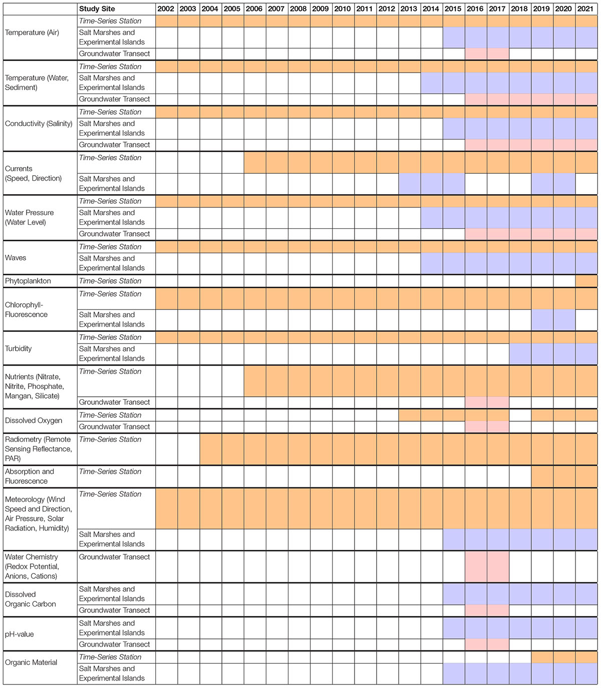
Table 3. Key-parameters recorded at different study sites of the Spiekeroog Coastal Observatory.
As the SCO is a structure that has evolved over the years, the state of data management and availability varies between the SCO elements. However, the overarching aim is to apply the FAIR (Findable, Accessible, Interoperable and Reusable) data principles7 to all data. Both raw and processed data (at each processing level) are stored on the servers of the University of Oldenburg in order to provide regular data backups. This includes also data processing scripts, quality assurance procedures, and the respective documentations. The ICBM established a special management program for in situ real-time data (InSiDa), mainly for storing the data from the Time-Series Station Spiekeroog, but recently, InSiDa serves more and more also as data storage for other SCO elements, e.g., the environmental data of the experimental islands. In general, all these data together with its metadata (e.g., sensor information, calibration sheets) are available on request, however, it is envisaged to make each dataset available to one or more databases within 2 years. Public availability is frequently realized by provision of the data to the World Data Center PANGAEA, where they are accessible under the identifier Spiekeroog8. In addition, the data overview on the SCO website9 redirects to the PANGAEA database. In some cases, e.g., extensive datasets, the data are organized in collections. Each collection serves as basis where data are divided into sections enabling an easy selection of required periods. Datasets available on PANGAEA and other databases are interlinked via persistent identifiers (e.g., DOIs). In addition to making datasets publicly available, also the emerging publications are envisaged to be open access wherever possible.
Some data of the SCO, especially the oceanographic data from the TSS, are also regularly fed into databases of other institutions or observatories, e.g., the German Oceanographic Data Center (DOD) at the Federal Maritime and Hydrographic Agency (BSH) in Hamburg, or the COSYNA data portal. There, the data supports, e.g., the prediction of storm surges and issuing of storm surge warnings. With the TSS, the SCO is also an important contributor to the European Marine Observation and Data Network (EMODnet). Here, the data serve, among other things, as input and validation for climate and operational models. The ICBM and the University of Oldenburg are further long-standing associate members of the international organizations NOOS, EuroGOOS, and thus GOOS, which bring together scientific institutions and government agencies to develop and implement monitoring and forecasting systems for the marine environment. Although some steps have already been accomplished, further streamlining the SCO’s data pipelines in accordance with FAIR principles will be an important task for the future.
Case Examples and Projects Using Spiekeroog Coastal Observatory
With its infrastructure, the SCO enables and hosts a multitude of interdisciplinary projects conducted on and around the island since 2002. The connection between observational approaches led to various scientific publications. The projects exchange data and use central elements of the observatory simultaneously, e.g., connections of boat trips, exchange of sensor technology, or accommodation. This applies for smaller student projects up to larger research groups. The section reveals the importance of the Spiekeroog Coastal Observatory by presenting case examples and projects utilizing the SCO (see Table 4 for an overview).

Table 4. Overview of projects highlighted herein.
BioGeoChemistry of Tidal Flats
The multidisciplinary research group Tidal Flats commenced its work in spring of 2001 and continued with two thoroughly reviewed extensions until 2009. The research group was coordinated by the ICBM with cooperation partners from the Max Planck Institute for Marine Microbiology (Bremen), the Senckenberg Institute (Wilhelmshaven), and the Institute of Physics of the University of Oldenburg. Several field campaigns brought together researchers from all involved subprojects to the Wadden Sea for several days in order to collect experimental data under the same environmental conditions. Field trips were organized and coordinated by the Mathematical Modeling Group of the ICBM.
In general, investigations of the research group aimed at a fundamental understanding of biogeochemical transformations in the water-column, at particles, the sediment-water interface, and the depths of the sediments (Rullkötter, 2009). Research was not only conducted experimentally, but processes were also described mathematically by integrative modeling (Grunwald et al., 2010). Modeling of the entire tidal flat ecosystem was performed using a semi-Lagrangian model. The newly developed Ecological Tidal Model (EcoTiM) simulates the cycling of carbon, nitrogen, phosphate, and silicate and describes the tidal, diurnal, and annual dynamics within the back-barrier system (Kohlmeier and Ebenhoh, 2009).
One still visible heritage of the research group is the TSS Spiekeroog (see section “Time-Series Station Spiekeroog”). Monitoring the in- and outflowing water body and its constituents was accompanied by experimental approaches (Lunau et al., 2006; Lübben et al., 2009).
The main sampling area was the Janssand, which appears to be a highly active bioreactor in which organic matter is demineralized microbially, affecting the biogeochemical composition of the sediments. Combined microbiological and geochemical analysis of sediment cores showed clear similarities between the subsurface of tidal flats and the deep biosphere tens to hundreds of meters below the seafloor (Wilms et al., 2006). The good accessibility of Wadden Sea sediments allowed a detailed description of microbial processes, which led to the development of methods that were subsequently applied to explore the deep sub-seafloor biosphere (Engelen and Cypionka, 2009).
Biodiversity-Ecosystem Functioning (BEF) Field Experiment
Experimental islands and salt marsh enclosed plots represent a natural laboratory that enables a long-term exploration of biodiversity ecosystem functioning and metacommunity processes. The large-scale set-up at the interface between marine and terrestrial communities allows to study interactions between local and regional processes under dispersal limited and unlimited conditions. Construction and set-up of the experiment were established during the project BEFmate (Balke et al., 2017). Building on the success of BEFmate, the research group DynaCom is now using the experimental set-up to accomplish a multitude of subprojects.
Dispersal processes at the marine-terrestrial interface are one focus of DynaCom. Simulating how small particles are transported by currents around islands will shed light into the movement of plant seeds that are dropped into the water at the edge of the salt marsh and carried by water currents. These models can be fed with information from the operational wave and current monitoring system installed at the TSS, making these new extensions very valuable in supporting dispersal studies. The experimental islands and salt marsh enclosed plots have also proven to be invaluable for understanding the dispersal processes of terrestrial and aquatic consumers into new habitats and along environmental gradients. For instance, Lange et al. (2020) demonstrated the negative impacts of increased sediment elevation on macrofaunal biodiversity and functional diversity caused by reduced inundation and vegetation cover. Additionally, Scherber et al. (2018) showed that the island heterogeneity played a major role in determining the richness and incidence of taxa.
Measuring a large number of environmental parameters is the basis for all DynaCom subprojects as the conditions in their immediate surrounding affect all organisms (Zielinski et al., 2018). The TSS is an important element that fills data gaps, either occurring during larger maintenance works or when local sensors fail. TSS data was hence used for several metacommunity studies (e.g., Lange et al., 2020). New approaches in environmental monitoring involve the use of a deep learning architecture for marine virtual sensor applications. This virtual sensor model compensates for the missing output of a real sensor by virtual output (Oehmcke et al., 2017). Malfunctions of on-site sensor systems around the experimental set-up are unpredictable but can be substantial. Thus, Oehmcke et al. (2018) suggest merging data from the experimental plots with the collected TSS data, as both data-sources are spatially relatively close to each other. With the convolutional LSTM model MarineNet, they replaced outputs of malfunctioning sensors, thus allowing a continuous analysis of on-site processes. This constant data flow was essential for many publications that require continuous environmental information from the salt marsh and the experimental islands (e.g., Lange et al., 2020). Using these data, it could be shown that highest species diversity and fine root biomass can be found at the intermediate inundation frequency and zonation of salt marsh vegetation reflects the availability of water sources along the inundation gradient (Redelstein et al., 2018a,b). Similarly, the initial colonization of vascular plants on salt marshes depended on the environmental conditions mediated by the elevation above mean sea level with most individuals colonizing the mid elevations, but higher elevations supporting larger species richness of initial communities (Lõhmus et al., 2020).
A framework was developed using functional trait dimensions of trophic metacommunities for a more unified approach on metacommunity ecology across trophic levels (Bauer et al., 2021). This streamlined approach in combination of the elements of SCO infrastructure will be utilized for upcoming research questions, e.g., understanding how dispersal and competition processes form the typical salt marsh zonation and how these communities will respond to the changing environment (Bearup and Blasius, 2016; Balke et al., 2017; Redelstein et al., 2018b).
Beach Research
The biogeochemistry of the shallow beach subterranean estuary was the focus of the project BIME. For BIME, the SCO was uniquely suitable as model site to conduct submarine groundwater discharge (SGD) research, because Spiekeroog has a relatively simple (terrestrial) hydrology and no substantial surface runoff. In the past three decades, SGD has revealed itself as a ubiquitous feature along the worlds’ coastlines. Assuming two conditions, a hydraulic gradient, and high hydraulic conductivities, essentially any meter of coastline is a conduit for land-based water, nutrients and pollutants to the coastal ocean. It is not yet known under which conditions subterranean estuaries (STE) as underground land-sea interfaces cause mitigation, or exacerbation, of terrestrial influences on the oceanic water column.
In BIME, SCO infrastructure was harnessed to investigate distributions of microbial communities, nutrients, trace elements, and dissolved organic matter in seawater, groundwater, and porewater as well as the underlying physical processes at Spiekeroog’s meso-tidal, high-energy northern beach. It has been proposed that it acts as a nitrate sink during winter and as a nitrate source during summer for the adjacent coastal water column (Ahrens et al., 2020). The uniqueness of the project lied in its novel approaches and developments of sampling strategies (grid sampling, high-resolution topography mapping) as well as rare combination of disciplines (biology, hydrogeology, and geochemistry) (Waska et al., 2019). The vicinity of the SCO infrastructure to the ICBM allows for frequent sampling campaigns in the scope of BIME. TSS data was combined with data from the beach study site to investigate electron acceptor dynamics over space and time, and to reveal a source-sink-switch of the beach for nitrate to the coastal water column (Ahrens et al., 2020). This is also influencing microbial community structures within the sediments. The structure of the microbial core community of generalists is disturbed during spring due to deeper nitrate and oxygen penetration depths (Degenhardt et al., 2020). Close collaborations with local stakeholders enabled an efficient knowledge transfer and contribute to the status of Spiekeroog as a scientific research hot spot amongst the East Frisian Islands. Furthermore, the continuous research output before, during, and after BIME further elucidates the role of high-energy beaches as highly active biogeochemical reactors of global relevance (Anschutz et al., 2009; Charbonnier et al., 2013; Degenhardt et al., 2020; Waska et al., 2021).
Following-up on investigations and results from BIME, the new research group DynaDeep has started in April 2021 conducting joint field campaigns on Spiekeroog. Like BIME, DynaDeep continues to build on close cooperation with local and national stakeholders such as the National Park Central Administration (NLPV), the National Park House Wittbülten, the local municipality on Spiekeroog, the local water supplier (OOWV) and the federal state authority (NLWKN).
BIME results indicated that the effects of hydro- and morpho dynamics on subsurface water flow and transport are potentially high at high-energy beaches (Greskowiak and Massmann, 2021, Figure 7). However, the processes are still not well understood, as are the related consequences on biogeochemical reactions and microbial habitat characteristics of the STE. While BIME focused on the upper meter of the beach lacking permanent infrastructure, the emphasis of DynaDeep is on the deep STE (up to 30 m depth below surface). DynaDeep will study groundwater flow patterns as a function of hydro- and morpho dynamics, delivering rates of biotic and abiotic organic matter transformation, and investigating related redox processes. Furthermore, it will assess transformation and fractionation of trace metals and metal isotopes. In addition, microbial interactions with organic matter will be investigated, as well as the diversity and metabolic functioning of microbial communities.
The dynamic saltwater-freshwater interfaces in the subsurface will be mapped regularly by direct push vertical soundings, accompanied by ground-based hydro-geophysics (e.g., geoelectrics, surface-nuclear magnetic resonance, ground-penetrating radar), and surface-based electrodes. Scientific sediment drilling will obtain undisturbed, microbially uncontaminated sediment cores for microbiological, petrological, and geochemical analyses as well as for laboratory experimental studies. STE porewater will be sampled using direct push and monitoring wells. A large suite of complementary parameters will be analyzed in the project ranging from environmental tracers, redox indicators and organic water constituents, trace elements and metal isotopes to microbial proxies and key-organisms.
The North Beach of Spiekeroog will be transformed from a campaign-based site into a long-term research site through the installation of permanent infrastructure. Therefore, the establishment of a Subterranean Estuary Online Observatory at the North Beach of the island is planned. This STE Online Observatory will consist of permanent infrastructure equipped with sensor systems as well as mobile equipment (i.e., small and large direct push units for sediment drilling, salinity probing, and porewater sampling). A mobile central field container will be placed at the dune base to enable online data transfer from the installed sensors, to store equipment, and to provide an information platform for the public. At the low water line, a new pole will serve as an additional instrumentation platform. A camera system mounted on the pole in combination with drone surveys and manual laser scanner surveys will provide high-resolution information on morpho-dynamics of the beach topography. A vertical electrode chain will be installed in the subsurface associated with the pole for constant monitoring of electrical conductivities in its surrounding (Grinat et al., 2018). Drill holes will be instrumented with multi-level observation wells to allow for long-term monitoring to generate high frequency time resolved data. The wells will be equipped with conventional loggers for electrical conductivity, pressure, and temperature, which will be complemented by innovative sensor systems for, e.g., oxygen, nitrate, and FDOM.
Plastic Pollution
The pollution of the marine environment with anthropogenic litter poses a major threat for marine and coastal ecosystems worldwide as well as in the North Sea region. The project Macroplastics was concerned with the investigation of pathways, sources, and the development of effective abatement strategies for the southern North Sea.
The dynamics of floating marine debris at the ocean’s surface have been investigated by several studies in the frame of the project (Meyerjürgens et al., 2020; Ricker and Stanev, 2020), but the transport from the sea to the coasts needs to be addressed through observational studies in order to translate these mechanisms into numerical models (Meyerjürgens et al., 2019). Once deposited at the coast, debris can also be returned to the ocean by wind gusts, waves, currents, tides, and extreme events (Stanev et al., 2019; von Schuckmann et al., 2020). Consequently, the washing ashore of litter and the possibility of it floating back into the ocean is an essential parameter for accurate estimates of the marine debris budgets. Observations to quantify these processes are not available and literature on this topic is very rare (van Sebille et al., 2020). However, the transport dynamics of plastic objects in coastal areas differ significantly from transport processes in open ocean and in situ data with high spatial and temporal resolution are essential for the validation and tuning purposes in numerical models.
To gain observational insights into the transport processes during litter standing, an X-band wave radar was installed for 6 months at Spiekeroog to observe surface currents and wave dynamics in the surf zone. In order to obtain high-resolution bathymetric data for the validation of numerical models the radar system measured water depth in a radius of 4 km (Hessner et al., 2014). A bottom mounted ADCP was installed in the swash zone for measurements of current and wave parameters over the water column, which were also used for the validation of hydro-dynamical coastal ocean models.
The coastal bathymetry and coastline morphology influence the three-dimensional transport patterns of particles due to turbulence induced by bathymetry gradients. In turn, the bathymetry in the surf zone of Spiekeroog itself is strongly influenced by sediment transport processes induced in particular by storm water surges (Bartholomä et al., 2009). As a result, the shoaling of waves in the surf zone is strongly depended on the rearrangement of sediments in the coastal area, which massively influences the wave-induced transport of particles (Stokes drift) at the sea surface.
In order to compare in situ Lagrangian observations with simulated particles, experiments with satellite-tracked drifters in the swash zone were performed within the SCO. Lagrangian trajectories of simulated and observed particles can be compared and numerical hydrodynamical models take advantage of the highly temporal and spatial hydrodynamical observations by the SCO to simulate the fate of particles in the surf zone. Drifter trajectories showed that tidal inlets act as convergence zones for floating particles, which can accumulate during high tide and moderate wind conditions. Spatial velocity data from X-band radar observations showed that extreme wind conditions can overshadow tidal currents due to strong wind-driven current velocities in the swash zone.
Coastal Ocean Darkening
Another project that took advantage of the SCO infrastructure is Coastal Ocean Darkening (COD). Light intensity and spectral quality have implications for primary production in marine systems, and they shape the ecological niche for a variety of organisms at all levels of the marine food web. Several studies suggest a decline of water transparency and thus light availability in coastal areas in the past (Aksnes et al., 2009; Capuzzo et al., 2013, 2015; Dupont and Aksnes, 2013), inspiring COD to investigate this phenomenon in more detail. Although the research was related to coastal areas in general, focus area of the project was the North Sea as an example for a highly utilized shelf sea. Aim of COD was to describe the light availability during the last 100 years on different spatial scales, and to make projections about the future using biogeochemical models with improved light parameterization (Thewes et al., 2020; Wollschläger et al., 2020). Furthermore, the work conducted in the project helped to refine established bio-optical concepts (Pitarch et al., 2019).
Besides historical observations of Secchi-depth and Forel-Ule color index as indicators for water transparency and color (Wernand, 2010; Wernand and van der Woerd, 2010; Garaba et al., 2014), also modern radiometric measurements (Garaba et al., 2014, 2015; Garaba and Zielinski, 2015) were evaluated in this context. In this respect, data of the radiometric time series obtained on the TSS since 2004 was a valuable contribution to the project, as it provided high frequency measurements of remote sensing reflectance, from which water transparency and color could be derived. This allowed an investigation of potential trends in these parameters in the Wadden Sea, where changes in environmental conditions are of special interest with regard to biodiversity and primary productivity. The high temporal coverage of the data also provided the opportunity to analyze the processes governing the light distribution in more detail. The trend of “coastal darkening” has been found to be regionally variable, and the Wadden Sea showed no strong trend within the coverage of the TSS radiometric data (unpublished results).
Furthermore, the project took advantage of the regular TSS maintenance work conduced with the research boats (see section “Research Boats”) in order to establish a regular water sampling routine (approx. biweekly, still continued after the end of the project). The samples were analyzed in the laboratory for hyperspectral absorption and fluorescence to provide additional information for the interpretation and analysis of the radiometric time series, but also to validate products derived from the AOP measurements.
However, the SCO served not only as data source to COD but was also contributing to the outreach component of the project, as the National Park House Wittbülten was an associated project partner and integrated COD in its permanent exhibition.
Real-World Laboratories for Ecosystem-Strengthening Coastal Protection
Coasts are often highly populated areas, and their ecosystems under pressure due to increasing human utilization. Especially in the light of climate change, the dependence on marine resources and coastal ecosystem services (e.g., touristic value and recreation) makes societies increasingly vulnerable to marine hazards like storm surges, land-loss, and sea-level rise. Thus, coastal protection measures are a necessity in order to cope with these hazards. Due to a growing awareness for the benefits of healthy ecosystems and in agreement with current policies, measures are desired that positively impact coastal ecosystems (Commission of the European Communities [CEC], 2002).
The project Gute Küste Niedersachsen is an interdisciplinary project of coastal engineers, marine scientists, and sociologists. In so-called real-world laboratories (Wanner et al., 2018), the effects and underlying processes of ecosystem-based coastal protection measurements are investigated. The generated knowledge aims to develop coastal management options that suit human needs but also consider ecosystem health. A core concept of the real-world laboratory approach is the close cooperation with local stakeholders, thus a co-design, co-production, and co-evaluation of the experiments (Franke et al., 2021).
Spiekeroog was selected as a location for a real-world laboratory since barrier islands are a typical element of the German coast. Here, in close vicinity to each other, directly exposed coastlines protected by dunes can be studied together with back-barrier tidal flats, salt marshes, traditional dikes, and groins. Furthermore, public acceptance and interest in scientific research is high, which is a prerequisite for the successful establishment of the real-world laboratory approach. This can be considered as an effect of the several research projects that have been previously conducted in the SCO, and their successful dissemination in the National Park House Wittbülten.
The scientific work in the project is focused on four aspects: (i) Development of an observation system that integrates terrestrial and marine data from (semi) permanent sensor installations into an environmental status assessment. This data will be supplemented and/or validated with data from dedicated field campaigns performed seasonally around the island. (ii) Quantification of the ecosystem services Spiekeroog provides based on the gathered data, as well as investigations regarding changes in these services associated with certain coastal protection measures. (iii) Utilization of field-gained knowledge to develop model systems (e.g., artificial plants that can be used on model dikes and in wave channels), which can be used to further understand the effects of different coastal protection measures under controlled laboratory conditions. (iv) Analysis of the social-ecological dimensions of ecological-strengthening coastal protection measures, e.g., cultural ecosystem services, identification with coastal landscapes, and acceptance of different measures.
The project will benefit from the infrastructure of the SCO, especially the TSS Spiekeroog and the sensor installations around the experimental islands and saltmarsh enclosed plots. The already existing data of these sensor installations can be used to establish a baseline and set new data in a broader context. For the short-term field campaigns, the research boats are an important asset for the project, as they allow research in shallower waters close to the coast. Finally, the National Park House Wittbülten is a valuable partner for disseminating the project’s aims and results, as well as establishing a dialog with local stakeholders, which is especially important with respect to the real-world laboratory approach of Gute Küste Niedersachsen.
Conclusion and Future Avenues
The SCO with its associated research activities improves our understanding of environmental change and anthropogenic impacts on coastal areas. In the course of its existence, the SCO has been successfully established within the scientific community by being subject of eight projects from 2001 to 2021. Ever since, 1238 data sets have been published on PANGEA according to the keyword “Spiekeroog” and a geographic bounding box of 53.73–53.80°N resp. 7.64–7.85°E. The outcome of this data has been applied to at least 196 papers which refer to the island of Spiekeroog and the ICBM. Since the onset of the SCO, hydrographic and meteorological parameters were quality-controlled and published in international repositories like EMODnet, PANGAEA, and the German Oceanographic Data Center DOD. It is the nature of any environmental observatory to be dynamic in its technical infrastructure and scientific utilization. The origin and still a central element of the Spiekeroog Coastal Observatory is the Time-Series Station with its continuous record of environmental data, which have a key function for the current research of the ICBM in the southern North Sea. Over the last 19 years, the SCO observational capabilities have experienced continuous growth yet also changes, both linked to the life cycles of projects and corresponding funding. The recent approval of the new research unit DynaDeep and the selection of Spiekeroog as real-world laboratory site will further promote this process, leading to future opportunities to expand observational infrastructure and generate new scientific insights. DynaDeep will profit from the existing SCO infrastructure and at the same time, further strengthen the SCO with the establishment of the Subterranean Estuary Online Observatory at the North Beach of the island.
Furthermore, as the SCO’s development benefits from new projects; the extending capabilities in turn, enable the implementation of more complex and ambitious projects. Thereby the attractiveness of the location for future coastal research activities increases. The scientific value of the SCO is, however, beyond data provision. As mentioned, its infrastructure also provides the means for testing new sensors, systems, and platforms, not only by academic, but also commercial partners. Further, with technological progress, also new avenues in data stream management and quality control will be pursued, utilizing artificial intelligence and machine learning approaches (e.g., event detection). The integrated and dynamic structure of the SCO will therefore be an ideal testbed for such approaches in future.
However, sustaining a coastal observatory like the SCO which is based on project funding emphasizes the build-up of new facilities, although the maintenance or refurbishment of existing components is of similar importance. Furthermore, at the end of its lifetime, infrastructure has also to be dismantled and the respective areas must be re-naturalized. This concerns, e.g., to the experimental islands after the end of the projects that utilize them. But also to components which are not devoted to a specific project, like the TSS, which has to be replaced in approx. 12–15 years (depending on the aging of the material). These steps will require careful planning to minimize the impact on the UNESCO World Heritage Site in which they are located, but they will also require adequate financial resources. Thus, soon, the challenge to maintain, adapt, and improve the SCO independent of project funds needs to be tackled. This demands institutional support and funding opportunities that sustain observational capacities. For the SCO, the exploration of respective possibilities has been started, but has not yet been fully evaluated. In summary, important prerequisites for a sustained operation are certainly (i) the continued scientific exploitation of the SCO; (ii) its openness to collaborations, transforming it into a national facility; and (iii) a further integration into other international programs, like LTER, GOOS, or EMODnet.
The multitude of projects associated with the SCO and their interdisciplinary nature is further an asset for the training of the next generation of scientists. The diverse elements and research fields of the observatory provide a broad range of learning opportunities, from (micro-) biology to biogeochemistry to sensor technology. The different study programs of the University of Oldenburg as well as the Jade University of Applied Sciences in Wilhelmshaven already take advantage of this by regularly organizing excursions and Summer Schools. Due to the success of these events, these activities will be continued in the future; however, they would not be possible without accommodation and laboratory facilities like those provided by the SCO element National Park House Wittbülten.
The communication of research aims and results is an important part of the scientific work in the SCO. In cooperation with the National Park House Wittbülten, a series of lectures is planned that will start in 2022 and will report on the research on the island, such as the latest results from the DynaDeep or DynaCom research groups. The series will run during the holiday season, so that both locals and tourists will be addressed. A further aspect of the SCO science communication that will be strengthened in the future with dedicated projects is the engagement of people in Citizen Science. Contributions from pupils, students, locals, and tourists could be beneficial to future research, e.g., by regular data collection, reducing data gaps between measurement campaigns. A broad target group could be addressed with easy-to-use offers, e.g., taking photos of beach morphology or ocean color with their own smartphones. Furthermore, it is planned to establish a science information path along the elements of the SCO that will contain information points with short introductions to the elements and a QR code that links to more information (pictures, videos, audio messages, virtual reality expeditions, etc.) on the respective part of the SCO-website.
However, SCO science communication is not only important in the context of providing information to the interested public, but also to prevent or resolve conflicts emerging from the placement of infrastructure in otherwise utilized or protected areas. Also in this respect, the National Park House Wittbülten is a valuable asset for the SCO, as it offers the possibility to sustain a continuous dialog with residents and tourists. A good example is the installation of the experimental islands in the back tidal flats, which initially excited strong curiosity but also concerns. Thus, it was important to lay out the rationale behind the experiments to the public and seek for an exchange of opinions. Thanks to conversations and presentations organized involving the National Park House Wittbülten, the issue could be clarified on both factual and emotional level. In conclusion, we see that the SCO could serve as a role model for other (coastal) observatories, integrating research, academic and environmental education, scientific dissemination as well as interaction possibilities with different kinds of local stakeholders. In this way, the SCO and other observatories of its kind will significantly contribute toward a sustainable management of marine ecosystems under increasing anthropogenic influences and changing environmental conditions.
Author Contributions
OZ and DP were responsible for drafting, preparing, and writing of the manuscript as well as for the continuous process of the work. JSc, JW, and CT contributed in writing and processing of the manuscript. MA contributed to figure preparation and production. All authors contributed to writing and proofreading of the manuscript.
Funding
This work has been supported through the research groups DynaCom (FOR 2716) and DynaDeep (FOR 5094) funded by the German Research Foundation (DFG). The project Gute Küste Niedersachsen (76251-17-5/19) is funded by the Lower-Saxony Ministry of Research and Culture (MWK-VW). Freshwater lens research was founded by DFG (Ma-3274/6-1). The projects BIME (ZN3184), BEFmate (ZN2930), COD (VWZN3175), and Macroplastics (Grant ZN3176) were also funded by MWK-VW and the research group BioGeoChemie des Watts (FOR 432) was funded by DFG.
Conflict of Interest
The authors declare that the research was conducted in the absence of any commercial or financial relationships that could be construed as a potential conflict of interest.
Publisher’s Note
All claims expressed in this article are solely those of the authors and do not necessarily represent those of their affiliated organizations, or those of the publisher, the editors and the reviewers. Any product that may be evaluated in this article, or claim that may be made by its manufacturer, is not guaranteed or endorsed by the publisher.
Acknowledgments
We are very grateful to the support and cooperation with Nationalparkverwaltung Niedersächsisches Wattenmeer, the Common Wadden Sea Secretariat, the Niedersächsischer Landesbetrieb für Wasserwirtschaft, Küsten- und Naturschutz (NLWKN), the Oldenburgisch-Ostfriesischer Wasserverband (OOWV), the Nationalpark House Wittbülten, Florian Fock and his colleagues of the Hermann-Lietz School on Spiekeroog as well as the administration, municipality, and mayor of Spiekeroog. The ICBM workshop team in Wilhelmshaven is highly acknowledged for their great technical and logistical support. Thanks to all project members, colleagues, and all other helping hands in the field during sampling campaigns, and within the lab. Special thanks to Ursel Gerken for administrative support. We further thank the reviewers and the editor, as their comments provided valuable contributions to improve the manuscript.
Supplementary Material
The Supplementary Material for this article can be found online at: https://www.frontiersin.org/articles/10.3389/fmars.2021.754905/full#supplementary-material
Footnotes
- ^ https://www.goosocean.org/
- ^ https://emso.eu/
- ^ https://www.jerico-ri.eu/
- ^ https://www.ilter.network/
- ^ www.lernlabor-wattenmeer.de
- ^ https://literacy.ocean.org/
- ^ https://www.go-fair.org/fairprinciples
- ^ https://www.pangaea.de/?q=spiekeroog
- ^ https://uol.de/icbm/sco/daten
References
Aguzzi, J., Mànuel, A., Condal, F., Guillén, J., Nogueras, M., del Rio, J., et al. (2011). The new seafloor observatory (OBSEA) for remote and long-term coastal ecosystem monitoring. Sensors 11, 5850–5872. doi: 10.3390/s110605850
Ahrens, J., Beck, M., Marchant, H. K., Ahmerkamp, S., Schnetger, B., and Brumsack, H. -J. (2020). Seasonality of organic matter degradation regulates nutrient and metal net fluxes in a high energy sandy beach. J. Geophys. Res. Biogeosci. 125:e2019JG005399. doi: 10.1029/2019JG005399
Aksnes, D. L., Dupont, N., Staby, A., Fiksen, O., Kaartvedt, S., and Aure, J. (2009). Coastal water darkening and implications for mesopelagic regime shifts in Norwegian fjords. Mar. Ecol. Prog. Ser. 387, 39–49. doi: 10.3354/meps08120
Anschutz, P., Smith, T., Mouret, A., Deborde, J., Bujan, S., Poirier, D., et al. (2009). Tidal sands as biogeochemical reactors. Estuar. Coast. Shelf Sci. 84, 84–90. doi: 10.1016/j.ecss.2009.06.015
Austin, T., Edson, J., McGillis, W., von Alt, C., Purcell, M., Petitt, R., et al. (2000). Martha’s vineyard coastal observatory: a long term facility for monitoring air-sea processes. Oceans Conf. Rec. (IEEE) 3, 1937–1941.
Badewien, T. H., Zimmer, E., Bartholomä, A., and Reuter, R. (2009). Towards continuous long-term measurements of suspended particulate matter (SPM) in turbid coastal waters. Ocean Dyn. 59, 227–238. doi: 10.1007/s10236-009-0183-8
Balke, T., Lõhmus, K., Hillebrand, H., Zielinski, O., Haynert, K., Meier, D., et al. (2017). Experimental salt marsh islands: a model system for novel metacommunity experiments. Estuar. Coast. Shelf Sci. 198, 288–298. doi: 10.1016/j.ecss.2017.09.021
Balke, T., Stock, M., Jensen, K., Bouma, T. J., and Kleyer, M. (2016). A global analysis of the seaward salt marsh extent: the importance of tidal range. Water Resour. Res. 52, 3775–3786. doi: 10.1002/2015WR018318
Barnes, C. R., Best, M. M. R., and Zielinski, A. (2008). The NEPTUNE canada an overview of the progress of installation and the design of the science experiments. Sea Technol. 49, 10–14.
Bartholomä, A., Kubicki, A., Badewien, T. H., and Flemming, B. W. (2009). Suspended sediment transport in the German Wadden Sea—seasonal variations and extreme events. Ocean Dyn. 59, 213–225. doi: 10.1007/s10236-009-0193-6
Baschek, B., Schroeder, F., Brix, H., Riethmüller, R., Badewien, T. H., Breitbach, G., et al. (2017). The coastal observing system for Northern and Arctic Seas (COSYNA). Ocean Sci. 13, 379–410. doi: 10.5194/os-13-379-2107
Bauer, B., Kleyer, M., Albach, D. C., Blasius, B., Brose, U., Ferreira-Arruda, T., et al. (2021). Functional trait dimensions of trophic metacommunities. Ecography 44, 1486–1500. doi: 10.1111/ecog.05869
Bearup, D., and Blasius, B. (2016). Ecotone formation induced by the effects of tidal flooding: a conceptual model of the mud flat-coastal wetland ecosystem. Ecol. Complex. 32, 217–227. doi: 10.1016/j.ecocom.2016.11.005
Beck, M., Dellwig, O., Kolditz, K., Freund, H., Liebezeit, G., Schnetger, B., et al. (2007). In situ pore water sampling in deep intertidal flat sediments. Limnol. Oceanogr. Methods 5, 136–144. doi: 10.4319/lom.2007.5.136
Beck, M., Dellwig, O., Liebezeit, G., Schnetger, B., and Brumsack, H.-J. (2008b). Spatial and seasonal variations of sulphate, dissolved organic carbon, and nutrients in deep pore waters of intertidal flat sediments. Estuar. Coast. Shelf Sci. 79, 307–316. doi: 10.1016/j.ecss.2008.04.007
Beck, M., Dellwig, O., Schnetger, B., and Brumsack, H.-J. (2008a). Cycling of trace metals (Mn, Fe, Mo, U, V, Cr) in deep pore waters of intertidal flat sediments. Geochim. Cosmochim. Acta 72, 2822–2840. doi: 10.1016/j.gca.2008.04.013
Beck, M., Köster, J., Engelen, B., Holstein, J., Gittel, A., Könneke, M., et al. (2009). Deep pore water profiles reflect enhanced microbial activity towards tidal flat margins. Ocean Dyn. 59, 371–383. doi: 10.1007/s10236-008-0176-z
Beck, M., Reckhardt, A., Amelsberg, J., Bartholomä, A., Brumsack, H.-J., Cypionka, H., et al. (2017). The drivers of biogeochemistry in beach ecosystems: a cross-shore transect from the dunes to the low water-line. Mar. Chem. 190, 35–50. doi: 10.1016/j.marchem.2017.01.001
Beck, M., Riedel, T., Graue, J., Köster, J., Kowalski, N., Wu, C. S., et al. (2011). Imprint of past and present environmental conditions on microbiology and biogeochemistry of coastal Quaternary sediments. Biogeosciences 8, 55–68. doi: 10.5194/bg-8-55-2011
Bell, P. S., and Osler, J. C. (2011). Mapping bathymetry using X-band marine radar data recorded from a moving vessel. Ocean Dyn. 61, 2141–2156. doi: 10.1007/s10236-011-0478-4
Benway, H. M., Lorenzoni, L., White, A. E., Fiedler, B., Levine, N. M., Nicholson, D. P., et al. (2019). Ocean time series observations of changing marine ecosystems: an era of integration, synthesis, and societal applications. Front. Mar. Sci. 6:393. doi: 10.3389/fmars.2019.00393
Brazilian Sea Observatory (2019). Sea Observatory and Operational Modelling System for the South-Eastern Brazilian Shelf (Issue December). Available online at: https://brazilianseaobservatory.org/wp-content/uploads/2020/01/L2-FinalReport_update_v1.pdf (accessed January 10, 2022).
Burchard, H., and Badewien, T. H. (2015). Thermohaline residual circulation of the Wadden Sea. Ocean Dyn. 65, 1717–1730. doi: 10.1007/s10236-015-0895-x
Burchard, H., Flöser, G., Staneva, J. V., Badewien, T. H., and Riethmüller, R. (2008). Impact of density gradients on net sediment transport into the Wadden Sea. J. Phys. Oceanogr. 38, 566–587. doi: 10.1175/2007JPO3796.1
Capuzzo, E., Painting, S. J., Forster, R. M., Greenwood, N., Stephens, D. T., and Mikkelsen, O. A. (2013). Variability in the sub-surface light climate at ecohydrodynamically distinct sites in the North Sea. Biogeochemistry 113, 85–103. doi: 10.1007/s10533-012-9772-6
Capuzzo, E., Stephens, D., Silva, T., Barry, J., and Forster, R. M. (2015). Decrease in water clarity of the southern and central North Sea during the 20th century. Glob. Chang. Biol. 21, 2206–2214. doi: 10.1111/gcb.12854
Ceccaroni, L., Piera, J., Wernand, M. R., Zielinski, O., Busch, J. A., van der Woerd, H. J., et al. (2020). Citclops: a next-generation sensor system for the monitoring of natural waters and a citizens’ observatory for the assessment of ecosystems’ status. PLoS One 15:e0230084. doi: 10.1371/journal.pone.0230084
Chang, T. S., Flemming, B. W., Tilch, E., Bartholomä, A., and Wöstmann, R. (2006). Late Holocene stratigraphic evolution of a back-barrier tidal basin in the East Frisian Wadden Sea, southern North Sea: transgressive deposition and its preservation potential. Facies 52, 329–340. doi: 10.1007/s10347-006-0080-2
Charbonnier, C., Anschutz, P., Poirier, D., Bujan, S., and Lecroart, P. (2013). Aerobic respiration in a high-energy sandy beach. Mar. Chem. 155, 10–21. doi: 10.1016/j.marchem.2013.05.003
Commission of the European Communities [CEC] (2002). Recommendation of the European Parliament and Council of 30May 2002 Concerning the Implementation of Integrated Coastal Zone Management in Europe 2002/413/EC. Luxembourg: CEC.
Crise, A., d’Alcalà, M. R., Mariani, P., Petihakis, G., Robidart, J., Iudicone, D., et al. (2018). A conceptual framework for developing the next generation of Marine OBservatories (MOBs) for science and society. Front. Mar. Sci. 5:318. doi: 10.3389/fmars.2018.00318
Dawe, T. C., Bird, L., Talkovic, M., Brekke, K., Osborne, D. J., and Etchemendy, S. (2005). “Operational support of regional cabled observatories the MARS facility,” in Proceedings of OCEANS 2005 MTS/IEEE, Washington, DC. doi: 10.1109/OCEANS.2005.1639906
Degenhardt, J., Dlugosch, L., Ahrens, J., Beck, M., Waska, H., and Engelen, B. (2020). Seasonal dynamics of microbial diversity at a sandy high energy beach reveal a resilient core community. Front. Mar. Sci. 7:573570. doi: 10.3389/fmars.2020.573570
Dellwig, O., Beck, M., Lemke, A., Lunau, M., Kolditz, K., Schnetger, B., et al. (2007). Non-conservative behaviour of molybdenum in coastal waters: coupling geochemical, biological, and sedimentological processes. Geochim. Cosmochim. Acta 71, 2745–2761. doi: 10.1016/j.gca.2007.03.014
Dewey, R., and Tunnicliffe, V. (2003). “VENUS: future science on a coastal mid-depth observatory. SSC 2003,” in Proceedings of the 3rd International Workshop on Scientific Use of Submarine Cables and Related Technologies, Tokyo, 232–233. doi: 10.1109/SSC.2003.1224149
Dobrynin, M., Gayer, G., Pleskachevsky, A., and Günther, H. (2010). Effects of waves and currents on the dynamics and seasonal variations of suspended particulate matter in the North Sea. J. Mar. Syst. 82, 1–20. doi: 10.1016/j.jmarsys.2010.02.012
Dupont, N., and Aksnes, D. L. (2013). Centennial changes in water clarity of the baltic sea and the north sea. Estuar. Coast. Shelf Sci. 131, 282–289. doi: 10.1016/j.ecss.2013.08.010
Engelen, B., and Cypionka, H. (2009). The subsurface of tidal-flat sediments as a model for the deep biosphere. Ocean Dyn. 59, 385–391. doi: 10.1007/s10236-008-0166-1
Farcy, P., Durand, D., Charria, G., Painting, S. J., Tamminem, T., Collingridge, K., et al. (2019). Toward a European coastal observing network to provide better answers to science and to societal challenges; The JERICO research infrastructure. Front. Mar. Sci. 6:529. doi: 10.3389/fmars.2019.00529
Fitzgerald, D. M., Penland, S., and Nummedal, D. (1984). Control of Barrier Island shape by inlet sediment bypassing: East Frisian Islands, West Germany. Mar. Geol. 60, 355–376. doi: 10.1016/S0070-4571(08)70154-7
Franke, A., Peters, K., Hinkel, J., Hornidge, A. K., Schlüter, A., Zielinski, O., et al. (2021). Making the UN Ocean Decade work? The potential for, and challenges of, transdisciplinary research & real-world laboratories for building towards ocean solutions. OSF [Preprints]. doi: 10.31219/osf.io/6sfe8
Friedrichs, C. T., and Perry, J. E. (2001). Tidal salt marsh morphodynamics: a synthesis. J. Res. 27, 7–37.
Gallager, S. M., Lerner, S., York, A. D., Miller, E., and Girard, A. (2008). “Design, installation, and operation of the PLUTO observatory, Isla de Canales de Tierra, Panama,” in Proceedings of the Oceans 2008, Quebec City, QC. doi: 10.1109/OCEANS.2008.5151994
Gao, H., Matyka, M., Liu, B., Khalili, A., Kostka, J. E., Collins, G., et al. (2012). Intensive and extensive nitrogen loss from intertidal permeable sediments of the Wadden Sea. Limnol. Oceanogr. 57, 185–198. doi: 10.4319/lo.2012.57.1.0185
Garaba, S. P., and Zielinski, O. (2015). An assessment of water quality monitoring tools in an estuarine system. Remote Sens. Appl. Soc. Environ. 2, 1–10. doi: 10.1016/j.rsase.2015.09.001
Garaba, S. P., Badewien, T. H., Braun, A., Schulz, A.-C., and Zielinski, O. (2014). Using ocean colour products to estimate turbidity at the Wadden Sea time series station Spiekeroog. J. Europ. Opt. Soc. Rap. Public. 9:14020. doi: 10.2971/jeos.2014.14020
Garaba, S., Friedrichs, A., Voß, D., and Zielinski, O. (2015). Classifying natural waters with the forel-ule colour index system: Results, applications, correlations and crowdsourcing. Int. J. Environ. Res. Public Health 12, 16096–16109. doi: 10.3390/ijerph121215044
Garcia, C. A. E., Pereira, E. S., and Copertino, M. (2016). “The Brazilian Coastal Monitoring System (SiMCosta) for Climate Studies,” in Proceedings of the Conferência Internacional do INCT para Mudanças Climáticas.
Gerlach, A. (1993). Biogeochemistry of nitrogen in a coastal dune succession on Spiekeroog (Germany) and the impact of climate. Phytocoenologia 23, 115–127. doi: 10.1127/phyto/23/1993/115
Gerlach, A., Albers, E. A., and Broedlin, W. (1994). Development of the nitrogen cycle in the soils of a coastal dune succession. Acta Bot. Neerl. 43, 189–203. doi: 10.1111/j.1438-8677.1994.tb00744.x
Giani, L., and Buhmann, S. (2004). Entwicklung, Eigenschaften und Klassifikation von Dünenböden der Ostfriesischen Inseln – am Beispiel Spiekeroogs. J. Plant Nut. Soil Sci. 167, 645–648. doi: 10.1002/jpln.200421394
Grashorn, S., Lettmann, K. A., Wolff, J.-O., Badewien, T. H., and Stanev, E. V. (2015). East Frisian Wadden Sea hydrodynamics and wave effects in an unstructured-grid model. Ocean Dyn. 65, 419–434. doi: 10.1007/s10236-014-0807-5
Gräwe, U., Flöser, G., Gerkema, T., Duran-Matute, M., Badewien, T. H., Schulz, E., et al. (2016). A numerical model for the entire Wadden Sea: skill assessment and analysis of hydrodynamics. J. Geophys. Res. Oceans 121, 5231–5251. doi: 10.1002/2016JC011655
Greskowiak, J., and Massmann, G. (2021). The impact of morphodynamics and storm floods on pore water flow and transport in the subterranean estuary. Hydrol. Process. 35:e14050. doi: 10.1002/hyp.14050
Grinat, M., Epping, D., and Meyer, R. (2018). Long-time resistivity monitoring of a freshwater/saltwater transition zone using the vertical electrode system SAMOS. E3S Web Conf. 54:9. doi: 10.1051/e3sconf/20185400009
Grünenbaum, N., Ahrens, J., Beck, M., Gilfedder, B. S., Greskowiak, J., Kossack, M., et al. (2020b). A multi-method approach for quantification of in-and exfiltration rates from the subterranean estuary of a high energy beach. Front. Earth Sci. 8:571310. doi: 10.3389/feart.2020.571310
Grünenbaum, N., Greskowiak, J., Sültenfuß, J., and Massmann, G. (2020a). Groundwater flow and residence times below a meso-tidal high-energy beach: a model-based analyses of salinity patterns and 3H-3He groundwater ages. J. Hydrol. 587:124948. doi: 10.1016/j.jhydrol.2020.124948
Grunwald, M., Dellwig, O., Kohlmeier, C., Kowalski, N., Beck, M., Badewien, T. H., et al. (2010). Nutrient dynamics in a back barrier tidal basin of the Southern North Sea: time-series, model simulations, and budget estimates. J. Sea Res. 64, 199–212. doi: 10.1016/j.seares.2010.02.008
Grunwald, M., Dellwig, O., Liebezeit, G., Schnetger, B., Reuter, R., and Brumsack, H. J. (2007). A novel time-series station in the Wadden Sea (NW Germany): first results on continuous nutrient and methane measurements. Mar. Chem. 107, 411–421. doi: 10.1016/j.marchem.2007.04.003
Hayes, M. O. (1980). General morphology and sediment patterns in tidal inlets. Sediment. Geol. 26, 139–156. doi: 10.1016/0037-0738(80)90009-3
He, Q., and Silliman, B. R. (2019). Climate change, human impacts, and coastal ecosystems in the anthropocene. Curr. Biol. 29, R1021–R1035. doi: 10.1016/j.cub.2019.08.042
Hessner, K., Reichert, K., Borge, J. C. N., Stevens, C. L., and Smith, M. J. (2014). High-resolution X-band radar measurements of currents, bathymetry and sea state in highly inhomogeneous coastal areas. Ocean Dyn. 64, 989–998. doi: 10.1007/s10236-014-0724-7
Hillebrand, H., and Matthiessen, B. (2009). Biodiversity in a complex world: consolidation and progress in functional biodiversity research. Ecol. Lett. 12, 1405–1419. doi: 10.1111/j.1461-0248.2009.01388.x
Holinde, L., Badewien, T. H., Freund, J. A., Stanev, E. V., and Zielinski, O. (2015). Processing of water level derived from water pressure data at the Time Series Station Spiekeroog. Earth Syst. Sci. Data 7, 289–297. doi: 10.5194/essd-7-289-2015
Holt, T., Greskowiak, J., Seibert, S. L., and Massmann, G. (2019). Modeling the evolution of a freshwater lens under highly dynamic conditions on a currently developing Barrier Island. Geofluids 2019:9484657. doi: 10.1155/2019/9484657
Holt, T., Greskowiak, J., Sültenfuß, J., and Massmann, G. (2021). Groundwater age distribution in a highly dynamic coastal aquifer. Adv. Water Resour. 149:103850. doi: 10.1016/j.advwatres.2021.103850
Holt, T., Seibert, S. L., Greskowiak, J., Freund, H., and Massmann, G. (2017). Impact of storm tides and inundation frequency on water table salinity and vegetation on a juvenile barrier island. J. Hydrol. 554, 666–679. doi: 10.1016/j.jhydrol.2017.09.014
Howarth, J., and Palmer, M. (2011). The Liverpool Bay coastal observatory. Ocean Dyn. 61, 1917–1926. doi: 10.1007/s10236-011-0458-8
Intergovernmental Oceanographic Commission [IOC] (2019). The Science We Need for the Ocean we Want: The United Nations Decade of Ocean Science for Sustainable Development (2021-2030). IOC/BRO/2018/7 REV, UN, 2019. Paris: Intergovernmental Oceanographic Commission.
Isermann, M. (2011). Patterns in species diversity during succession of coastal dunes. J. Coast. Res. 27, 661–671. doi: 10.2112/JCOASTRES-D-09-00040.1
JPI-Oceans (2015). Strategic R&I Agenda, Joint Programming Initiative Healthy and Productive Seas and Oceans. Bruxelles: JPI Oceans.
Kirwan, M. L., and Megonigal, J. P. (2013). Tidal wetland stability in the face of human impacts and sea-level rise. Nature 504, 53–60. doi: 10.1038/nature12856
Kohlmeier, C., and Ebenhoh, W. (2009). Modelling the biogeochemistry of a tidal flat ecosystem with EcoTiM. Ocean Dyn. 59, 393–415. doi: 10.1007/s10236-009-0188-3
Kopf, A., Bicak, M., Kottmann, R., Schnetzer, J., Kostadinov, I., Lehmann, K., et al. (2015). The ocean sampling day consortium. GigaScience 4:27. doi: 10.1186/s13742-015-0066-5
Kröncke, I., Becker, L. R., Badewien, T. H., Bartholomä, A., Schulz, A.-C., and Zielinski, O. (2018). Near- and Offshore macrofauna communities and their physical environment in a south-eastern North Sea sandy beach system. Front. Mar. Sci. 5:497. doi: 10.3389/fmars.2018.00497
Ladage, F., and Stephan, H. (2004). Morphologische Entwicklung im Seegat Harle und seinem Einzugsgebiet. Norderney: Forschungsstelle Küste.
Lange, G., Bininda-Emonds, O. R. P., Hillebrand, H., Meier, D., Moorthi, S. D., Schmitt, J. A., et al. (2020). Elevation gradient affects the development of macrozoobenthic communities in the Wadden Sea: A field experiment with artificial islands. J. Exp. Mar. Biol. Ecol. 523:151268. doi: 10.1016/j.jembe.2019.151268
Lee, D. R. (1977). A device for measuring seepage flux in lakes and estuaries. Limnol. Oceanogr. 22, 140–147. doi: 10.4319/lo.1977.22.1.0140
Leonardi, N., and Fagherazzi, S. (2014). How waves shape salt marshes. Geology 42, 887–890. doi: 10.1130/G35751.1
Lettmann, K. A., Wolff, J.-O., and Badewien, T. H. (2009). Modeling the impact of wind and waves on suspended particulate matter fluxes in the East Frisian Wadden Sea (southern North Sea). Ocean Dyn. 59, 239–262. doi: 10.1007/s10236-009-0194-5
Liebezeit, G., Dittmann, S., Schleier, U., Günther, C. P., Villbrandt, M., Niesel, V., et al. (1998). ELAWAT, Elastizität des Ökosystems Wattenmeer. Projektsynthese; Abschlußbericht der Ökosystemforschung Niedersächsisches Wattenmeer (Teil B). Forschungszentrum Terramare. Wilhelmshaven: TIBKAT, 1999.
Lõhmus, K., Balke, T., and Kleyer, M. (2020). Spatial and temporal patterns of initial plant establishment in salt marsh communities. J. Veg. Sci. 31, 1122–1132. doi: 10.1111/jvs.12915
Lübben, A., Dellwig, O., Koch, S., Beck, M., Badewien, T. H., Fischer, S., et al. (2009). Distributions and characteristics of dissolved organic matter in temperate coastal waters (Southern North Sea). Ocean Dyn. 59, 263–275. doi: 10.1007/s10236-009-0181-x
Lunau, M., Lemke, A., Dellwig, O., and Simon, M. (2006). Physical and biogeochemical controls of microaggregate dynamics in a tidally affected coastal ecosystem. Limnol. Oceanogr. 51, 847–859. doi: 10.4319/lo.2006.51.2.0847
Lynch, T. P., Morello, E. B., Evans, K., Richardson, A. J., Rochester, W., Steinberg, C. R., et al. (2014). IMOS National reference stations: a continental-wide physical, chemical and biological coastal observing system. PLoS One 9:e113652. doi: 10.1371/journal.pone.0113652
Mathis, M., Elizalde, A., Mikolajewicz, U., and Pohlmann, T. (2015). Variability patterns of the general circulation and sea water temperature in the North Sea. Progr. Oceanogr. 135, 91–112. doi: 10.1016/j.pocean.2015.04.009
Mayer, J., and Ziemek, H.-P. (2006). Offenes experimentieren. Forschendes lernen im biologieunterricht. Unter. Biol. 317, 4–12.
Meyerjürgens, J., Badewien, T. H., Garaba, S. P., Wolff, J.-O., and Zielinski, O. (2019). A state-of-the-art compact surface drifter reveals pathways of floating marine litter in the German bight. Front. Mar. Sci. 6:58. doi: 10.3389/fmars.2019.00058
Meyerjürgens, J., Ricker, M., Schakau, V., Badewien, T. H., and Stanev, E. V. (2020). Relative dispersion of surface drifters in the North Sea: the effect of tides on mesoscale diffusivity. J. Geophys. Res. Oceans 125:e2019JC015925. doi: 10.1029/2019JC015925
Mirtl, M., Borer, E. T., Djukic, I., Forsius, M., Haubolda, H., Hugod, W., et al. (2018). Genesis, goals and achievements of long-termecological research at the global scale: a critical review of ILTER and future directions. Sci. Total Environ. 626, 1439–1462. doi: 10.1016/j.scitotenv.2017.12.001
Möller, I., Kudella, M., Rupprecht, F., Spencer, T., Paul, M., van Wesenbeeck, B. K., et al. (2014). Wave attenuation over coastal salt marshes under storm surge conditions. Nat. Geosci. 7, 727–731. doi: 10.1038/ngeo2251
Moltmann, T., Poiner, I., Wiltshire, M., and Glynn, W. (2016). From Observations to Impact: The First Decade of IMOS. Battery Point, TAS: Marine Matters
Montes-Herrera, E., and Muller-Karger, F. (2019). Global observational needs and resources for marine biodiversity. Front. Mar. Sci. 6:367. doi: 10.3389/fmars.2019.00367
Muller-Karger, F. E., Miloslavich, P., Bax, N. J., Simmons, S., Costello, M. J., Sousa Pinto, I., et al. (2018). Advancing marine biological observations and data requirements of the complementary essential ocean variables (EOVs) and essential biodiversity variables (EBVs) frameworks. Front. Mar. Sci. 5:211. doi: 10.3389/fmars.2018.00211
NLWKN (2010). Generalplan Küstenschutz Niedersachsen - Ostfriesische Inseln. Norden: Niedersächsischer Landesbetrieb für Wasserwirtschaft, Küsten- und Naturschutz.
Oehmcke, S., Zielinski, O., and Kramer, O. (2017). “Recurrent neural networks and exponential PAA for virtual marine sensors,” in Proceedings of the 2017th International Joint Conference on Neural Networks (IJCNN), Anchorage, AK: IEEE, 4459–4466. doi: 10.1109/IJCNN.2017.7966421
Oehmcke, S., Zielinski, O., and Kramer, O. (2018). Input quality aware convolutional LSTM networks for virtual marine sensors. Neurocomputing 275, 2603–2615. doi: 10.1016/j.neucom.2017.11.027
Oldenburg-Ostfriesischer Wasserverband [OOWV] (2009). Wasserrechtsantrag. Antrag auf Bewilligung einer Grundwasserentnahme Über 180.000 m3/a für das Wasserwerk Spiekeroog. Lower Saxony: Oldenburg-Ostfriesischer Wasserverband.
Oldenburg-Ostfriesischer Wasserverband [OOWV] (2012). Niederschlags- und Sickerwasserdaten von 1984–2011. Oldenburg: Oldenburg-Ostfriesischer Wasserverband.
Pitarch, J., van der Woerd, H. J., Brewin, R. J. W., and Zielinski, O. (2019). Optical properties of Forel-Ule water types deduced from 15 years of global satellite ocean color observations. Remote Sens. Environ. 231:111249. doi: 10.1016/j.rse.2019.111249
Pollmann, T., Böttcher, M. E., and Giani, L. (2021). Young soils of a temperate barrier island under the impact of formation and resetting by tides and wind. Catena 202:105275. doi: 10.1016/j.catena.2021.105275
Pollmann, T., Junge, B., and Giani, L. (2018). Landscapes and soils of North Sea barrier islands: a comparative analysis of the old West and young East of Spiekeroog Island (Germany). Erdkunde 72, 273–286. doi: 10.3112/erdkunde.2018.04.02
Pollmann, T., Tsukamoto, S., Frechen, M., and Giani, L. (2020). Rate of soil formation in Arenosols of dunes on Spiekeroog Island (Germany). Geoderma Reg. 20:e00246. doi: 10.1016/j.geodrs.2019.e00246
Reckhardt, A., Beck, M., Seidel, M., Riedel, T., Wehrmann, A., Bartholomä, A., et al. (2015). Carbon, nutrient and trace metal cycling in sandy sediments: a comparison of high-energy beaches and backbarrier tidal flats. Estuar. Coast. Shelf Sci. 159, 1–14. doi: 10.1016/j.ecss.2015.03.025
Reckhardt, A., Seibert, S. L., Holt, T., Ahrens, J., Beck, M., Massmann, G., et al. (2021). Cycling of redox-sensitive trace metals in barrier island freshwater lenses. Sci. Total Environ. 768:144964. doi: 10.1016/j.scitotenv.2021.144964
Redelstein, R., Coners, H., Knohl, A., and Leuschner, C. (2018a). Water sources of plant uptake along a salt marsh flooding gradient. Oecologia 188, 607–622. doi: 10.1007/s00442-018-4229-9
Redelstein, R., Dinter, T., Hertel, D., and Leuschner, C. (2018b). Effects of inundation, nutrient availability and plant species diversity on fine root mass and morphology across a saltmarsh flooding gradient. Front. Plant Sci. 9:98. doi: 10.3389/fpls.2018.00098
Reuter, R., Badewien, T. H., Bartholomä, A., Braun, A., Lübben, A., and Rullkötter, J. (2009). A hydrographic time series station in the Wadden Sea (southern North Sea). Ocean Dyn. 59, 195–211. doi: 10.1007/s10236-009-0196-3
Ricker, M., and Stanev, E. V. (2020). Circulation of the European northwest shelf: a Lagrangian perspective. Ocean Sci. 16, 637–655. doi: 10.5194/os-16-637-2020
Riedel, T., Lettmann, K., Beck, M., and Brumsack, H. J. (2010). Tidal variations in groundwater storage and associated discharge from an intertidal coastal aquifer. J. Geophys. Res. Oceans 115:C04013. doi: 10.1029/2009jc005544
Rockström, J., Richardson, K., and Steffen, W. (2017). A Fundamental Misrepresentation of the Planetary Boundaries Framework. Stockholm: Stockholm Resilience Centre, 20.
Rockström, J., Steffen, W., Noone, K., Persson, Å., Chapin, F. S. III, Lambin, E. F., et al. (2009). A safe operating space for humanity. Nature 461, 472–475. doi: 10.1038/461472a
Röper, T., Greskowiak, J., and Massmann, G. (2014). Detecting small groundwater discharge springs using handheld thermal infrared imagery. Groundwater 52, 936–942. doi: 10.1111/gwat.12145
Röper, T., Greskowiak, J., Freund, H., and Massmann, G. (2013). Freshwater lens formation below juvenile dunes on a barrier island (Spiekeroog, Northwest Germany). Estuar. Coast. Shelf Sci. 121-122, 40–50. doi: 10.1016/j.ecss.2013.02.004
Röper, T., Kröger, K. F., Meyer, H., Sültenfuss, J., Greskowiak, J., and Massmann, G. (2012). Groundwater ages, recharge conditions and hydrochemical evolution of a barrier island freshwater lens (Spiekeroog, Northern Germany). J. Hydrol. 454-455, 173–186. doi: 10.1016/j.jhydrol.2012.06.011
Røy, H., Lee, J. S., Jansen, S., and de Beer, D. (2008). Tide-driven deep pore-water flow in intertidal sand flats. Limnol. Oceanogr. 53, 1521–1530. doi: 10.4319/lo.2008.53.4.1521
Rullkötter, J. (2009). The back-barrier tidal flats in the southern North Sea - a multidisciplinary approach to reveal the main driving forces shaping the system. Ocean Dyn. 59, 157–165. doi: 10.1007/s10236-009-0197-2
Rüssmeier, N., Hahn, A., Nicklas, D., and Zielinski, O. (2017). A research port test bed based on distributed optical sensors and sensor fusion framework for ad hoc situational awareness. J. Sens. Sens. Syst. 6:37. doi: 10.5194/jsss-6-37-2017
Ryabinin, V., BarbieÌre, J., Haugan, P., Kullenberg, G., Smith, N., McLean, C., et al. (2019). The UN decade of ocean science for sustainable development. Front. Mar. Sci. 6:470. doi: 10.3389/fmars.2019.00470
Scherber, C., Andert, H., Niedringhaus, R., and Tscharntke, T. (2018). A barrier island perspective on species–area relationships. Ecol. Evol. 8, 12879–12889. doi: 10.1002/ece3.4726
Schmidkunz, H. (2003). Das Forschend-Entwickelnde Unterrichtsverfahren, Problemlösen im Naturwissenschaftlichen, Unterricht. 6. Auflage Edn. Hohenwarsleben: Westarp Wissenschaften-Verlagsgesellschaft, 2003.
Schofield, O., Bergmann, T., Bissett, P., Grassle, J. F., Haidvogel, D. B., Kohut, J., et al. (2002). The long-term ecosystem observatory: an integrated coastal observatory. IEEE J. Ocean. Eng. 27, 146–154. doi: 10.1109/JOE.2002.1002469
Schulz, A.-C., Badewien, T. H., Garaba, S. P., and Zielinski, O. (2016). Acoustic and optical methods to infer water transparency at Time Series Station Spiekeroog, Wadden Sea. Ocean Sci. 12:1155. doi: 10.5194/os-12-1155-2016
Schulz, J., Möller, K. O., Bracher, A., Hieronymi, M., Cisewski, B., Zielinski, O., et al. (2015). Aquatische optische technologien in Deutschland. Meereswiss. Ber. Warnemünde 97, 1–92. doi: 10.12754/msr-2015-0097
Seibert, S. L., Böttcher, M. E., Schubert, F., Pollmann, T., Giani, L., Tsukamoto, S., et al. (2019). Iron sulfide formation in young and rapidly-deposited permeable sands at the land-sea transition zone. Sci. Total Environ. 649, 264–283. doi: 10.1016/j.scitotenv.2018.08.278
Seibert, S. L., Böttcher, M. E., Waska, H., Holt, T., Pollmann, T., Greskowiak, J., et al. (2021). Hydrogeochemistry of near-surface groundwater on a developing barrier island (Spiekeroog, Germany): the role of inundation, season and vegetation. J. Hydrol. 597:126139. doi: 10.1016/j.jhydrol.2021.126139
Seibert, S. L., Holt, T., Reckhardt, A., Ahrens, J., Beck, M., Pollmann, T., et al. (2018). Hydrochemical evolution of a freshwater lens below a barrier island (Spiekeroog, Germany): the role of carbonate mineral reactions, cation exchange and redox processes. Appl. Geochem. 92, 196–208. doi: 10.1016/j.apgeochem.2018.03.001
Seidel, M., Graue, J., Engelen, B., Köster, J., Sass, H., and Rullkötter, J. (2012). Advection and diffusion determine vertical distribution of microbial communities in intertidal sediments as revealed by combined biogeochemical and molecular biological analysis. Organ. Geochem. 52, 114–129. doi: 10.1016/j.orggeochem.2012.08.015
Sindowski, K.-H. (1970). Erläuterung zu Blatt Spiekeroog Nr. 2212. Hannover: Niedersächsisches Landesamt für Bodenforschung.
SMCRI Central Coordination Unit (2018). Shallow Marine and Coastal Research Infrastructure. Washington, DC: NRF.
Smyth, T., Fishwick, J., Bell, T., and Widdicombe, S. (2015). The Western channel observatory - collecting rare and precious time series from photons to fish. Mag. Challeng. Soc. Mar. Sci. 21, 32–34.
Soukissian, T. H., and Chronis, G. (2000). Poseidon: a marine environmental monitoring, forecasting and information system for the Greek seas. Mediterr. Mar. Sci. 1, 71–78. doi: 10.12681/mms.12
Stanev, E. V., Badewien, T. H., Freund, H., Grayek, S., Hahner, F., Meyerjürgens, J., et al. (2019). Extreme westward surface drift in the North Sea: public reports of stranded drifters and Lagrangian tracking. Cont. Shelf Res. 177, 24–32. doi: 10.1016/j.csr.2019.03.003
Stanev, E. V., Flemming, B. W., Bartholomä, A., Staneva, J. V., and Wolff, J.-O. (2007). Vertical circulation in shallow tidal inlets and back-barrier basins. Cont. Shelf Res. 27, 798–831. doi: 10.1016/j.csr.2006.11.019
Stanev, E., Wolff, J. O., Burchard, H., Bolding, K., and Flöser, G. (2003). On the circulation in the East Frisian Wadden sea: numerical modeling and data analysis. Ocean Dyn. 53, 27–51. doi: 10.1007/s10236-002-0022-7
Staneva, J., Stanev, E. V., Wolff, J.-O., Badewien, T. H., Reuter, R., Flemming, B., et al. (2009). Hydrodynamics and sediment dynamics in the German Bight. A focus on observations and numerical modelling in the East Frisian Wadden Sea. Cont. Shelf Res. 29, 302–319. doi: 10.1016/j.csr.2008.01.006
Thewes, D., Stanev, E. V., and Zielinski, O. (2020). Sensitivity of a 3D shelf sea ecosystem model to parameterizations of the underwater light field. Front. Mar. Sci. 6:816. doi: 10.3389/fmars.2019.00816
Tintoré, J., Vizoso, G., Casas, B., Ruiz, S., Heslop, E., Renault, L., et al. (2012). “SOCIB: the impact of new marine infrastructures in understanding and forecasting the Mediterranean Sea,” in CIESM: Designing Med-SHIPS: A Program for Repeated Oceanographic Surveys, Supetar, Brac Island, 11–14 May 2011, CIESM Workshop Monographs Edn, ed. F. Briand (Paris: CIESM), 99–118.
Valle-Levinson, A., Stanev, E., and Badewien, T. H. (2018). Tidal and subtidal exchange flows at an inlet of the Wadden Sea. Estuar. Coast. Shelf Sci. 202, 270–279. doi: 10.1016/j.ecss.2018.01.013
van Sebille, E., Aliani, S., Law, K. L., Maximenko, N., Alsina, J. M., Bagaev, A., et al. (2020). The physical oceanography of the transport of floating marine debris. Environ. Res. Lett. 15:023003. doi: 10.1088/1748-9326/ab6d7d
von Schuckmann, K., Le Traon, P. Y., Smith, N., Pascual, A., Djavidnia, S., Gattuso, J. P., et al. (2020). Copernicus marine service ocean state report, issue 4. J. Operat. Oceanogr. 13(Suppl. 1), S1–S172. doi: 10.1080/1755876X.2020.1785097
Wanner, M., Hilger, A., Westerkowski, J., Rose, M., Stelzer, F., and Schäpke, N. (2018). Towards a cyclical concept of real-world laboratories. disP Plan. Rev. 54, 94–114. doi: 10.1080/02513625.2018.1487651
Waska, H., Greskowiak, J., Ahrens, J., Beck, M., Ahmerkamp, S., Böning, P., et al. (2019). Spatial and temporal patterns of pore water chemistry in the inter-tidal zone of a high energy beach. Front. Mar. Sci. 6:154. doi: 10.3389/fmars.2019.00154
Waska, H., Simon, H., Ahmerkamp, S., Greskowiak, J., Ahrens, J., Seibert, S. L., et al. (2021). Molecular traits of dissolved organic matter in the subterranean estuary of a high-energy beach: indications of sources and sinks. Front. Mar. Sci. 8:607083. doi: 10.3389/fmars.2021.607083
Wernand, M. R. (2010). On the history of the Secchi disc. J. Eur. Opt. Soc. 5:10013s. doi: 10.2971/jeos.2010.10013s
Wernand, M. R., and van der Woerd, H. J. (2010). Spectral analysis of the Forel-Ule ocean colour comparator scale. J. Eur. Opt. Soc. 5:10014s. doi: 10.2971/jeos.2010.10014s
Wilms, R., Köpke, B., Sass, H., Chang, T. S., Cypionka, H., and Engelen, B. (2006). Deep biosphere-related bacteria within the subsurface of tidal flat sediments. Environ. Microbiol. 8, 709–719. doi: 10.1111/j.1462-2920.2005.00949.x
Wilms, R., Sass, H., Köpke, B., Cypionka, H., and Engelen, B. (2007). Methane and sulfate profiles within the subsurface of a tidal flat are reflected by the distribution of sulfate-reducing bacteria and methanogenic archaea. FEMS Microbiol. Ecol. 59, 611–621. doi: 10.1111/j.1574-6941.2006.00225.x
Wollschläger, J., Tietjen, B., Voß, D., and Zielinski, O. (2020). An empirically derived trimodal parameterization of underwater light in complex coastal waters – A case study in the North Sea. Front. Mar. Sci. 7:512. doi: 10.3389/fmars.2020.00512
Zielinski, O., Busch, J. A., Cembella, A. D., Daly, K. L., Engelbrektsson, J., Hannides, A. K., et al. (2009). Detecting marine hazardous substances and organisms: sensors for pollutants, toxins, and pathogens. Ocean Sci. 5, 329–349. doi: 10.5194/osd-6-953-2009
Zielinski, O., Meier, D., Lõhmus, K., Balke, T., Kleyer, M., and Hillebrand, H. (2018). Environmental conditions of a salt marsh biodiversity experiment on the island of Spiekeroog (Germany). Earth Syst. Sci. Data 10, 1843–1858. doi: 10.5194/essd-10-1843-2018
Glossary
SCO, Spiekeroog Coastal Observatory;
λ, Wavelength;
ADCP, Acoustic Doppler Current Profiler;
BEF, Biodiversity-Ecosystem Functioning;
BEFmate, Biodiversity-Ecosystem functioning across marine and terrestrial ecosystems;
BIME, Barrier Island Mass effect;
BSH, Federal Maritime and Hydrographic Agency;
BSO, Brazilian Sea Observatory;
C, Carbon;
CaCl2, Calcium chloride;
CDOM, Colored dissolved organic matter;
COD, Coastal Ocean Darkening;
COSYNA, Coastal Observing System for Northern and Arctic Seas;
CTD, Conductivity temperature depth;
DBU, Deutsche Bundesstiftung Umwelt;
DFG, German Research Foundation (Deutsche Forschungsgemeinschaft);
DOC, Dissolved organic carbon;
DOD, National German database;
DOI, Digital Object Identifier;
DOM, Dissolved organic matter;
DynaCom, Spatial community ecology in highly dynamic landscapes: from island biogeography to metaecosystems;
DynaDeep, The Dynamic Deep Subsurface of High-Energy Beaches;
EcoTiM, Ecological Tidal Model;
e.g., For example;
EMODnet, European Marine Observation and Data Network;
EU, European Union;
EuroGOOS, European Global Ocean Observing System;
FAIR, Findable, accessible, interoperable and reusable;
FDOM, Fluorescent dissolved organic matter;
Fe, Iron;
GOOS, Global Ocean Observatory System;
GPS, Global Positioning System;
GRAs, GOOS Regional Alliances;
Gute Küste, Gute Küste Niedersachsen – Reallabore für einen ökosystemstärkenden Küstenschutz an der niedersächsischen Küste;
h, Hours;
hp, Horsepower;
HZG, Helmholtz Zentrum Geesthacht;
ICBM, Institute for Chemistry and Biology of the marine Environment;
i.e., Id est;
IGMETS, International Group for Marine Ecological Time Series;
IMOS, Integrated Marine Observing System;
InSiDa, In situ real-time data;
kg, Kilogram;
km, Kilometer;
kW, Kilowatt;
L., Linnaeus;
LBCO, Liverpool Bay Coastal Observatory;
LEO, Long-Term Ecosystem Observatory;
LTER-D, Long Term Ecological Research – Germany;
m, Meter;
Macroplastics, Macroplastics Pollution in the Southern North Sea – Sources, Pathways and Abatement Strategies;
MARS, Monterey Accelerated Research System;
m asl, Meters above sea level;
mm, Millimeter;
Mn, Manganese;
m NHN, Normalhöhennull/Standard elevation zero;
MVCO, Martha’s Vineyard Coastal Observatory;
NEPTUNE, North East Pacific Time-series Underwater Networked Experiments Observatory;
NH4+, Ammonium;
NLPV, Nationalparkverwaltung (National Park Central Administration);
NLWKN, Niedersächsischer Landesbetrieb für Wasserwirtschaft, Küsten- und Naturschutz (German federal state authority);
nm, Nanometer;
NOOS, North West European Shelf Operational Oceanographic System;
NOx, Nitrogen oxide;
NO2–, Nitrite;
OBSEA, Expandable Seafloor Observatory;
OOWV, Oldenburgisch-Ostfriesischer Wasserverband;
Pers., Persons;
PLUTO, Panama LJL Underwater Tropical Observatory;
PO43–, Phosphate;
OM, Organic matter;
R/B, Research boat;
R/V, Research vessel;
SAEON, South African Environmental Observation Network;
SGD, Submarine groundwater discharge;
Si–, Silicate;
SiMCosta, Brazilian Coast Monitoring System;
SMCRI, Shallow Marine and Coastal Research Infrastructure;
SOCIB, Balearic Islands Coastal Observing and Forecasting System;
SOM, Soil organic matter;
spp, Species pluralis;
STE, Subterranean estuary;
Tidal Flats, BioGeoChemistry of Tidal Flats;
TSS Spiekeroog, Time-Series Station Spiekeroog;
UNESCO, United Nations Educational, Scientific and Cultural Organization;
UV, Ultraviolet;
V, Volt;
VENUS, Victoria Experimental Network Under the Sea;
WCO, Western Channel Observatory;
wt%, Mass fraction.
Keywords: Wadden Sea, coastal observatory, North Sea, German Bight, Spiekeroog, barrier island, infrastructure, tidal flat
Citation: Zielinski O, Pieck D, Schulz J, Thölen C, Wollschläger J, Albinus M, Badewien TH, Braun A, Engelen B, Feenders C, Fock S, Lehners C, Lõhmus K, Lübben A, Massmann G, Meyerjürgens J, Nicolai H, Pollmann T, Schwalfenberg K, Stone J, Waska H and Winkler H (2022) The Spiekeroog Coastal Observatory: A Scientific Infrastructure at the Land-Sea Transition Zone (Southern North Sea). Front. Mar. Sci. 8:754905. doi: 10.3389/fmars.2021.754905
Received: 07 August 2021; Accepted: 30 December 2021;
Published: 17 February 2022.
Edited by:
Johannes Karstensen, Helmholtz Association of German Research Centres (HZ), GermanyReviewed by:
Thanos Gkritzalis, Flanders Marine Institute, BelgiumJin-Yong Jeong, Korea Institute of Ocean Science and Technology (KIOST), South Korea
Copyright © 2022 Zielinski, Pieck, Schulz, Thölen, Wollschläger, Albinus, Badewien, Braun, Engelen, Feenders, Fock, Lehners, Lõhmus, Lübben, Massmann, Meyerjürgens, Nicolai, Pollmann, Schwalfenberg, Stone, Waska and Winkler. This is an open-access article distributed under the terms of the Creative Commons Attribution License (CC BY). The use, distribution or reproduction in other forums is permitted, provided the original author(s) and the copyright owner(s) are credited and that the original publication in this journal is cited, in accordance with accepted academic practice. No use, distribution or reproduction is permitted which does not comply with these terms.
*Correspondence: Oliver Zielinski, b2xpdmVyLnppZWxpbnNraUB1b2wuZGU=; Daniela Pieck, ZGFuaWVsYS5waWVja0B1b2wuZGU=
†These authors share first authorship