Abstract
Detailed management of the coastline is critical to the development of coastal states. However, the current classification of the coastline is relatively weak. This study proposed an automatic method to detect coastlines with category attributes based on multi-scale segmentation and multi-level inheritance classification. Fully integrating the advantages of multi-scale segmentation and multi-level classification, it solved the problems that traditional methods could not solve, such as extracting coastlines with categorical attributes, cultivation ponds that are easily affected by tidal flats, and complex coastal terrain. The Chinese GF-2 satellite images are used to extract various types of coastlines in Jiaozhou Bay and its surrounding areas such as the harbor-wharf coastline, silt coastline, pond coastline, rocky coastline, and sandy coastline. Compared with the human interpretation, it is found that the coastline extracted by our proposed method is different by 10.104 km in the harbor-wharf coastline, 0.099 km in the silt coastline, 2.677 km in the pond coastline, 8.831 km in the rocky coastline, and 0.218 km in the sandy coastline. Furthermore, compared to the object-based region growing integrating edge detection (OBRGIE) method, it is increased by 13.52%, 2.16%, 14.48%, 52.57%, and 22.97%, respectively. The results show that our proposed method is algorithmically more reasonable, accurate, and powerful. It can provide data support for refined coastline management.
Introduction
The coastline is the dividing line between sea and land formed by the average high tide of the spring tide for many years (Boak and Turner, 2005; Lui et al., 2011). It is the basis for coastal zone management, as well as the baseline for ocean navigation and sea area determination. The coastal zone is of great significance to economic development and the natural environment, although it has a higher risk of natural disasters such as tsunamis, waves, and coastal erosion (Mulder et al., 2011; Chen et al., 2021). Coastal areas have better resource exchange opportunities and economic development capabilities than inland areas (Rangel-Buitrago et al., 2015). Therefore, quickly extracting coastline from remote sensing images plays a vital role in the local government’s unified development, utilization, and management of coastal resources.
High-resolution remote sensing technology provides a technical means for coastline measurement with its advantages of high resolution and high positioning accuracy (Lui et al., 2011). With the rapid development of high-resolution satellites, the research on coastline extraction based on high-resolution images has also been widely used. Various research scholars have presented many methods for remote sensing interpretation of coastline; the automatic coastline extraction methods such as edge detection (Liu and Jezek, 2004; Sheng et al., 2021), region growth (Jin et al., 2020), threshold segmentation (Wang et al., 2016; Chen et al., 2022), deep learning (Liu et al., 2019), and object-oriented method (Ge et al., 2014; Wu et al., 2015) are used worldwide, while traditional methods, such as the visual interpretation of human–computer interaction, are still widely used by experts to extract coastal information (Yasir et al., 2021). The edge detection, regional growth, and threshold segmentation methods are easily affected by the complex coastal environment, and the type attributes of the coastline cannot be obtained (Yasir et al., 2020; Chang et al., 2021; Yi et al., 2022). The deep learning methods are required to produce a large number of samples, which is challenging to cover various scenes (Cheng, 2022). However, the object-oriented method can accurately obtain the boundary of coastal features through multi-scale segmentation and eliminate the influence of the coastal environment through classification results.
In recent years, the object-oriented method to obtain coastline has been widely used. Most scholars use the optimal global segmentation scale to extract coastlines without types (Wu et al., 2017; Bi et al., 2019; Zhang et al., 2022). For complex coasts, some new methods based on object orientation have been proposed, such as the OBRGIE method, which can delineate aquaculture coastlines (Zhang et al., 2013). A few scholars applied the object-oriented method to distinguish coastline types. It can be divided into two methods: one is to use the threshold method (Ju et al., 2017), and the other is to use the classification results (Wang, 2020) to determine the types of the coastline. However, their work has many flaws, such as the types of the coastline are not clear, or some coastlines will lose the category attribute. In view of these studies, we proposed a method to automatically detect coastlines with category attributes based on multi-scale segmentation and multi-level inheritance classification. Our main contributions are as follows:
-
Develop a method to automatically extract coastlines based on multi-scale segmentation and multi-level inheritance classification, which perfectly integrates multi-scale segmentation and multi-level inheritance classification. It can eliminate the influence of coastal terrain on coastline extraction and obtain accurate coastlines.
-
Identify various types of coastlines such as harbor-wharf coastline, pond coastline, rocky coastline, silt coastline, and sandy coastline.
Methods
In this paper, a coastline extraction method based on multi-scale segmentation and multi-level inheritance classification was presented. The technical steps are shown in Figure 1.
Figure 1
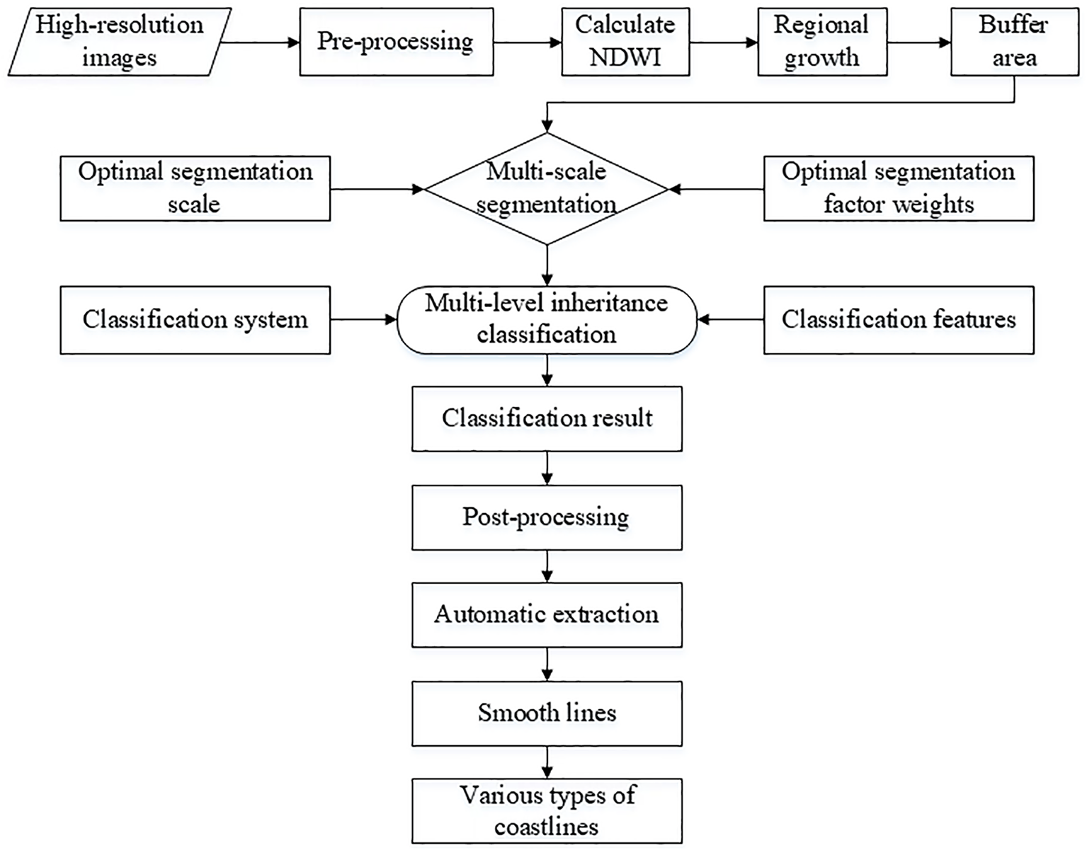
The overall methodology flowchart adopted in current research work for coastline extraction.
Multi-scale segmentation
Image segmentation is the first step in object-oriented image classification and analysis. The selection of the segmentation scale directly determines the size of the image object and the spatial scale level of the study area (Sun et al., 2018); thus, multi-scale segmentation results determine the location accuracy of coastline extraction. The method proposed by us performs optimal segmentation according to the characteristics of each coastal feature, which provides a basis for multi-level inheritance classification. The specific principle is shown in Figure 2.
Figure 2
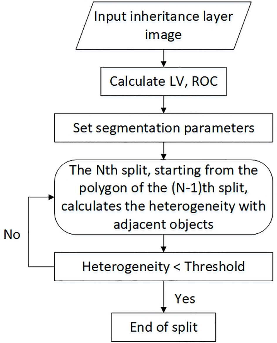
The principle of multi-scale segmentation.
The near-infrared (NIR) band is sensitive to water. To better segment ocean and land, the weight of the image bands is set as blue:green:red:NIR = 1:1:1:2. Image segmentation needs to determine the shape index and compactness, that is, the weight of shape heterogeneity and the weight of compactness heterogeneity. The sum of the weights of the shape index and the spectral index is 1. If the shape index is determined, the spectral index is also known, and the same is true for compactness and smoothness. Many scholars have used the relationship between homogeneity and heterogeneity to construct a segmentation evaluation index and an optimal segmentation scale model to select the optimal segmentation scale. However, the shape index and compactness cannot be automatically determined. Therefore, this paper adopts a trial-and-error approach to determine these two parameters.
When the segmentation scale matches the real ground objects, the local variance will reach the maximum value. At this time, the homogeneity within a single object and the difference between the objects will reach the maximum, and we can achieve effective segmentation of ground objects by calculating the maximum value of the difference. The Estimation of Scale Parameter (ESP) scale evaluation algorithm is used to calculate the possible value of the optimal scale (Drăguţ et al., 2014; Bai, 2020). The algorithm determines the optimal segmentation scale by calculating the mean of local variance (LV) and the rate of change of the mean local variance rate of change (ROC). Equations (1) and (2) are as follows:
where CL is the average brightness of a single image object in the band L, is the average brightness of all objects in the image in the band L, m is the sum of the number of objects in the image, K is the local variance of the target layer, and K - 1 is the local variance of a layer.
When the ROC reaches the maximum value, the segmentation scale corresponding to LV is the optimal possible value. Then, the optimal value is determined according to the segmentation effect.
Multi-level inheritance classification
In order to obtain accurate classification results of each coastal feature, we applied the multi-level inheritance classification. Its working principle is as follows: each classification layer extracts the corresponding coastal features and then inherits other features to the next classification layer until all coastal features are classified.
The selection of remote sensing interpretation marks is the key to correctly identifying the type of coastline and extracting the position of the coastline. The classification of coastal features must be based on the interpretation marks of the coastline. Based on the topic “Comprehensive Survey and Evaluation of China’s Offshore Oceans”, China surveyed and evaluated the coastline (Sun et al., 2011) and divided the coastline into a natural and an artificial coastline. The natural coastline is further subdivided into the following: rocky coastline, sandy coastline, silt coastline, and biological coastline. The artificial coastline includes the harbor-wharf coastline, the dam coastline, and the pond coastline, among others. The classification marks of coastal features in this paper refer to Sun’s interpretation marks research.
According to the characteristics of coastal features, a total of 48 index features, spectral features, geometric features, and texture features (Su et al., 2008; Wang, 2020) were selected for the classification features (Table 1).
Table 1
| Content | Features |
|---|---|
| Index | NDWI |
| Spectral | Brightness, Mean(4), Max, Difference standard deviation(4) |
| Edge contrast of neighbor pixels(4), StdDev.to neighbor pixels(4) | |
| Mean diff. to darker neighbors(4), Mean diff.to brighter neighbors(4) | |
| Geometric | Area, Border length, Length, Width, Length/Width, Volume |
| Asymmetry, Border index, Compactness, Density, Elliptic fit | |
| Rectangular fit, Roundness, Shape index | |
| Texture | Entropy, Contrast, GLCM Homogeneity(4), Angle 2nd Moment |
Categorical features including blue, green, red, and NIR bands.
Based on each object segmentation, a classification hierarchy is constructed according to the segmentation scale and segmentation effect. The nearest-neighbor classification method can extract coastal features layer by layer (Lin et al., 2018). Outside areas of the extracted coastal features are inherited to the next level to reclass. Different features have different feature expressions; when the classification features do not apply to a particular feature, classification accuracy will be reduced. It is necessary to optimize the features of the samples selected by each classification layer and finally classify all the features. Then, all classification results will be inherited to a layer.
Automatic coastline extraction steps
In this section, we describe how to automatically obtain coastlines with attributes based on the classification result. The classified coastal features have attribute information corresponding to various shorelines. In this part, we only need to filter the location according to the definition of coastline to obtain various coastlines.
-
(1) By merging objects of the same type at adjacent positions, we can reduce the number of objects and find the largest area of the ocean from it. The largest ocean as a basis for screening coastline.
-
(2) Filter the objects adjacent to the sea and convert them into line features. Since the classification result has attributes of coastline types, the line features also have corresponding attributes. Traverse lines with attributes of the breeding pond, harbor-wharf, rock, and land, then filter those that are adjacent to the biggest sea. The pond coastline, harbor-wharf coastline, rocky coastline, and silt coastline can get. Similarly, keep the beach attribute lines that are not adjacent to the sea. The sandy coastline is available.
-
(3) Multi-scale segmentation is based on pixels, and the obtained segmentation boundary will have a lot of sawtooth, which will cause the extracted coastline to be too curved. Thus, extracted lines need smoothing before the final coastline can be obtained.
Experiments
Study area and data
Jiaozhou Bay is located in the south coast of Jiaodong Peninsula, Qingdao City, Shandong Province, China, at 120° 06’–120° 22’ east longitude, 36° 03’–36° 15’ north latitude. The total area is 25 km wide from east to west and 32 km long from north to south, covers an area of 446 km2, and has a maximum water depth of 64 m and an average water depth of 7 m (Shen, 2001). Figure 3 depicts the geographical location of the study area.
Figure 3
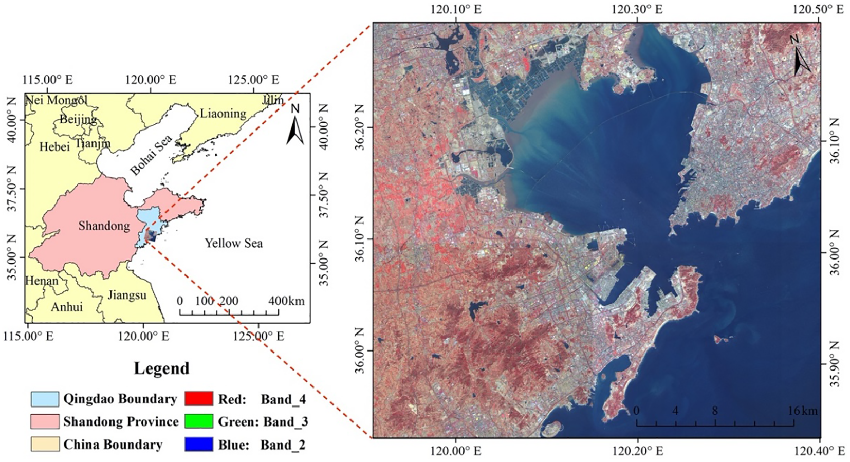
The geographical location of the study area.
In the current study, we collected four images from the GF-2 Chinese satellite of the year 2018 for the region of Jiaozhou Bay and surrounding areas. The images were acquired from the China Centre for Resources Satellite Data and Application website (http://36.112.130.153:7777/DSSPlatform/index.html), and the specific details of the parameters are listed in Table 2.
Table 2
| Sensor | Bands | Wavelength range /μm | Spatial resolution /m |
|---|---|---|---|
| Pan-camera | Pan | 0.45–0.89 | 1 |
| Blue | 0.45–0.52 | ||
| Green | 0.52–0.59 | ||
| Multi-camera | Red | 0.63–0.69 | 4 |
| NIR | 0.77–0.89 |
The details of the Chinese GF-2 sensor parameters used in the current study.
Data preprocessing is the premise of the whole experiment. First of all, radiometric calibration, atmospheric correction, and orthorectification were performed on the panchromatic bands of the four images. Radiometric calibration and orthorectification were performed on the multi-spectral bands. Then, the processed panchromatic and multi-spectral bands are fused and mosaicked to obtain a 1 × 1 m resolution image of the study area (Wang, 2021). Second, the Normalized Difference Water Index (NDWI) image was obtained by band calculation on the mosaicked image (Gao, 1996), and the water edge (coastline) was extracted from NDWI by the regional growing method (Liu et al., 2017; Incekara et al., 2018) (Figure 4A). Equation (3) is as follows:
Figure 4
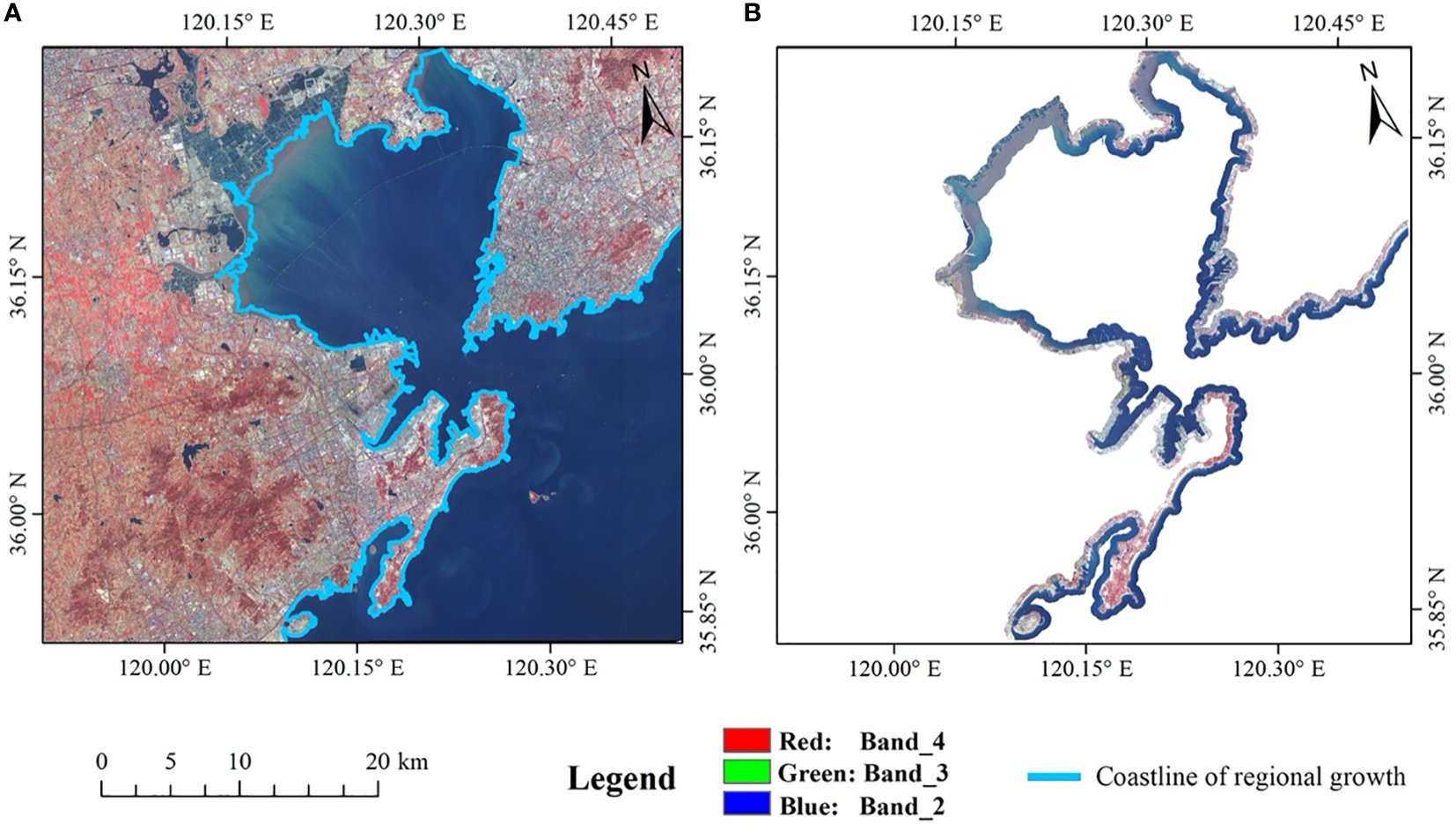
Image pre-processing: (A) the result of the regional growth method coastline extraction corresponding to NDWI; (B) the buffer of the research area.
where Green and NIR are bands of the GF-2 satellite image.
A 600-m-distance buffer was generated through the extracted water edge. Finally, crop the research area from the whole image scene as shown in Figure 4B.
Results
After investigating and analyzing the coastline of Jiaozhou Bay and its surrounding areas, they are classified into the harbor-wharf coastline, pond coastline, rocky coastline, silt coastline, and sandy coastline. The feature segmentation parameters corresponding to each type of coastline are determined (Tables 3, 4), and the segmentation effect is presented in Figure 5.
Table 3
| Index | Ocean | Sand | Harbor-wharf | Rock | Ship |
|---|---|---|---|---|---|
| LV | 145.74 | 318.9 | 267.82 | 302.75 | 281.64 |
| ROC | 0.42 | 1.47 | −2.36 | −0.41 | −0.16 |
LV and ROC of each coastal feature.
Table 4
| Content | Ocean | Sand | Harbor-wharf | Rock | Ship |
|---|---|---|---|---|---|
| Shape factor | 0.3 | 0.6 | 0.9 | 0.6 | 0.8 |
| Smoothness | 0.5 | 0.8 | 0.5 | 0.3 | 0.5 |
| Segmentation scale | 2,816 | 1,506 | 1,008 | 510 | 465 |
Segmentation parameters of each coastal land type.
Figure 5
Different types of segmentation effects: (A) ocean, (B) sand, (C) harbor-wharf, (D) ship, and (E) rock.
According to the interpretation of coastline signs, combined with the distribution characteristics of the coastline in Jiaozhou Bay and its surrounding areas, a classification system was established (Figure 6).
Figure 6
Coastline classification system.
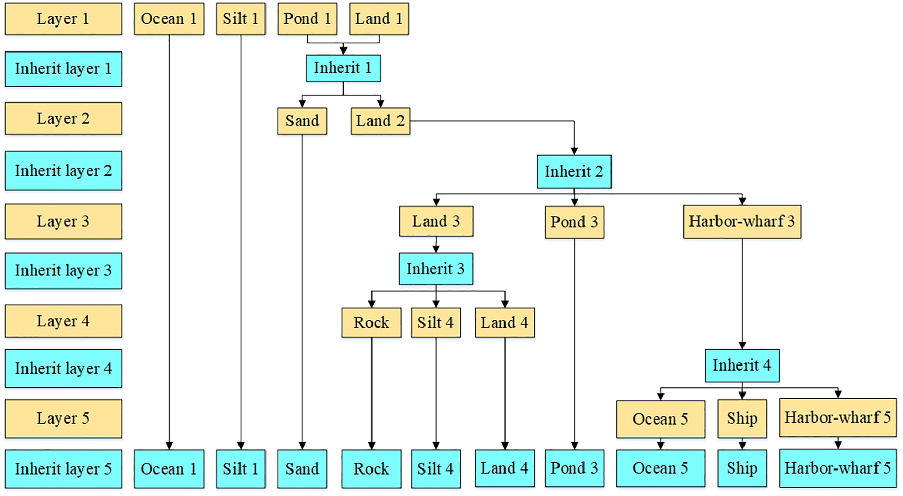
In the current study area, we performed multi-level inheritance classification to attain the classification result (Figure 7). Classification results include ocean, land, silt, pond, sand, ship, rock, and harbor-wharf. After processing the classification results, such as merging different categories, we can get an accurate boundary between ocean and land, on which the next step of coastline extraction can proceed.
Figure 7
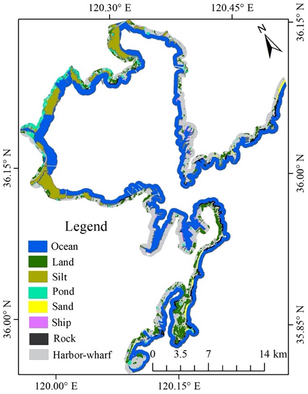
Classification result of coastal features of Jiaozhou Bay.
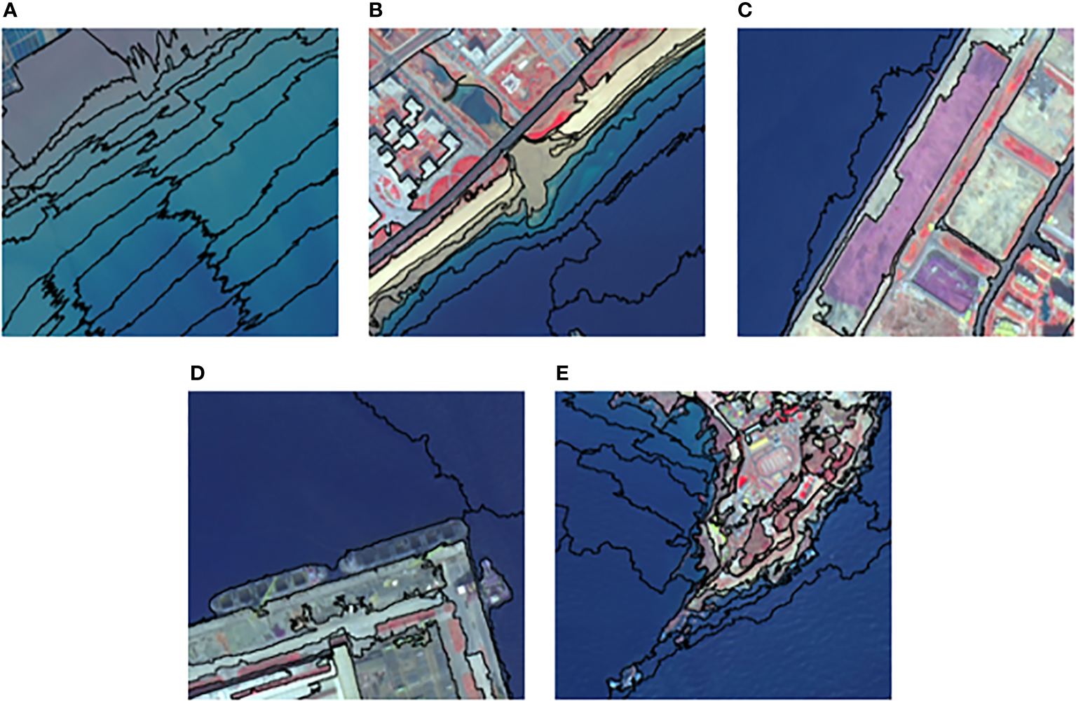
Based on the post-processing result, the harbor-wharf coastline, pond coastline, silt coastline, rocky coastline, and sandy coastline were automatically extracted and then smoothed to acquire the final coastline (Figure 8). The coastlines have a very good effect on visuals.
Figure 8
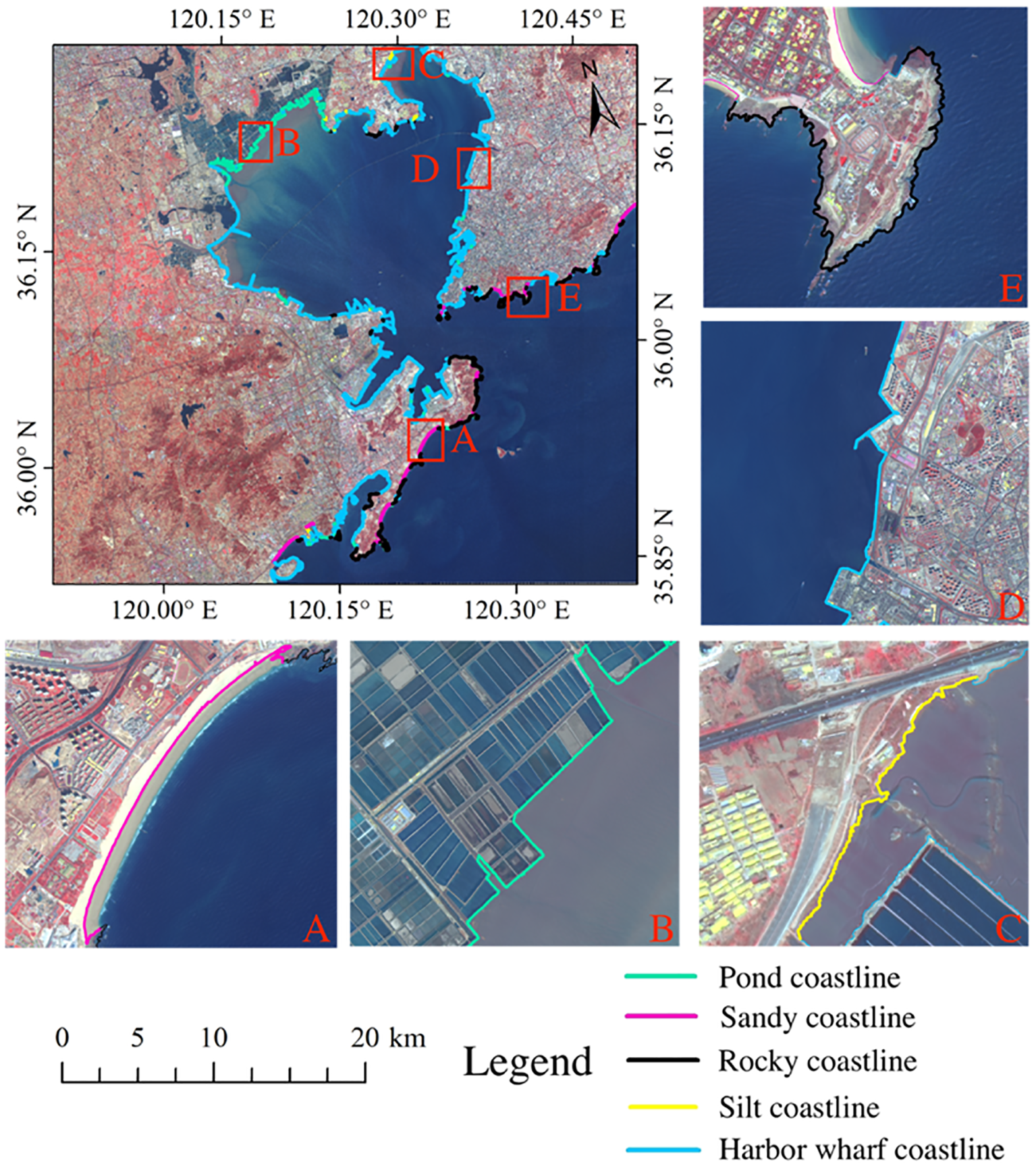
Automatic selection of various types of coastlines: From A-E represents the sandy coastline, pond coastline, silt coastline, harbor-wharf coastline, and rocky coastline.
Analysis
To verify the effectiveness of our proposed method, we used the methods of canny edge detection, regional growth, and OBRGIE to extract the coastline and compared the results with our method. In the canny operator, we set the threshold to 0.2, and in the regional growth method, the threshold is set to 0.15. Different techniques were used for the automated coastline extraction, but our algorithm is the most applicable because it creates an accurate result (Figure 9).
Figure 9
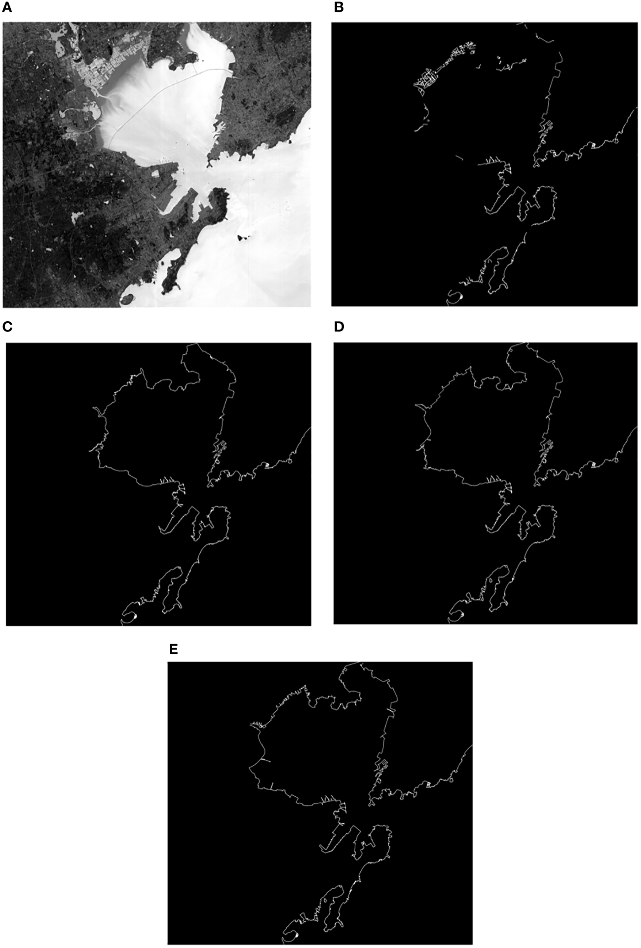
Extraction results of Jiaozhou Bay: (A) the original image, (B) canny edge detection coastline, (C) the regional growth extracted coastline, (D) OBRGIE extracted coastline, and (E) our method extracted coastline.
In different methods, manually adjust the river port line, Jiaozhou Bay Bridge, and the slender waterway in the breeding pond to make the evaluation standard uniform with human interpretation. The coastline of human interpretation is used as the truth value to evaluate the accuracy of the extracted coastline. The extracted results by different methods are superimposed for comparison, as shown in Figure 10. We concluded from Figure 10 that our extraction technique is more reliable and quicker than other techniques.
Figure 10
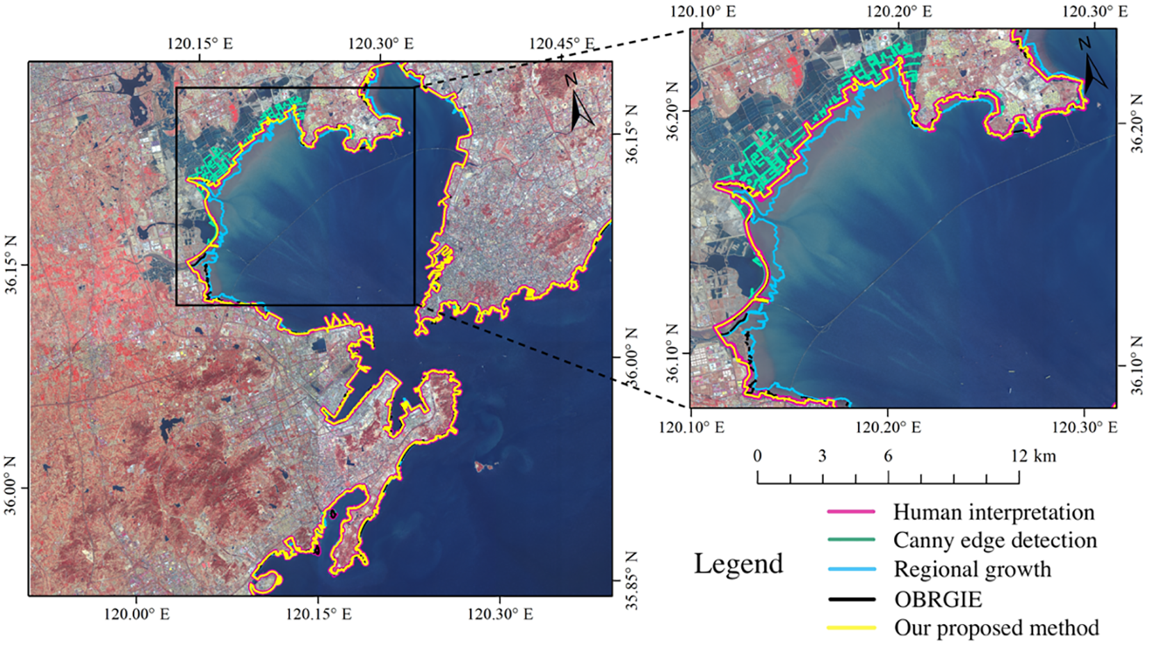
Coastline extraction results of different methods and comparisons.
Figures 9 , 10 show that in Jiaozhou Bay, the impact of seawater has formed several kilometers of tidal flats, and people have built large-scale breeding ponds on the edges of the tidal flats. The extraction results of canny edge detection in tidal flats and breeding ponds are not good, and the regional growth does not achieve the ideal extraction effect in some tidal flats. The OBRGIE method and our proposed method work well, but our method is more detailed and has better accuracy.
The accuracy assessment of the coastline can be described as length and position. The statistical length of various coastlines by our method is shown in Table 5. Mean offset (mean) and root mean square error (RMSE) are used to verify the position accuracy. For the coastline extracted by different methods, take a point every 10 m and make the vertical distance from the point to the coastline of human interpretation. The mean and RMSE of the vertical distance were calculated (Tables 6, 7).
Table 5
| Methods | Types | Total length | ||||
|---|---|---|---|---|---|---|
| Harbor-wharf coastline | Silt coastline | Pond coastline | Rocky coastline | Sandy coastline | ||
| Canny | – | – | – | – | – | 422.978 |
| Regional growth | – | – | – | – | – | 418.529 |
| OBRGIE | 182.913 | 3.395 | 63.682 | 107.732 | 20.708 | 413.248 |
| Human interpretation | 223.172 | 4.588 | 53.291 | 64.826 | 27.208 | 373.256 |
| Ours | 233.276 | 4.687 | 50.614 | 73.657 | 26.979 | 389.213 |
Length statistics of coastline types by different methods (unit: km).
Table 6
| Index | Methods | |||
|---|---|---|---|---|
| Canny | Regional growth | OBRGIE | Ours | |
| Mean | 22.39 | 95.12 | 30.56 | 7.94 |
| RMSE | 38.74 | 182.81 | 81.59 | 23.65 |
Position accuracy of different methods (unit: m).
Table 7
| Methods | Index | Types | ||||
|---|---|---|---|---|---|---|
| Harbor-wharf coastline | Pond coastline | Rocky coastline | Silt coastline | Sandy coastline | ||
| OBRGIE | Mean | 14.20 | 22.61 | 21.37 | 52.83 | 68.975 |
| RMSE | 30.14 | 59.16 | 55.85 | 66.98 | 105.40 | |
| Ours | Mean | 6.70 | 9.95 | 9.49 | 11.26 | 8.16 |
| RMSE | 21.89 | 34.93 | 17.71 | 20.78 | 17.48 | |
Position accuracy of coastline types in different methods (unit: m).
From Table 5, it can be determined that the canny edge detection and regional growth method cannot obtain the coastline types. The principle of the OBRGIE method is to first extract the coastline from the image and then classify the buffer zone. Finally, use ArcGIS to assign the attributes of the landline segment to the ocean line segment. When performing spatial connection of attributes, there are many possibilities in space between landline and ocean line segments, such as intersection and separation. This will lead to errors in the length of the acquired coastline and partial loss of attributes. Due to the defects of this method, the coastline extracted by this method has 34 km without the coastline type. Our method differs from human interpretation by 15.957 km. The lengths of our extracted harbor-wharf coastline, pond coastline, rocky coastline, silt coastline, and sandy coastline differ from the real coastline by 10.104 km, 2.676 km, 8.831 km, 0.099 km, and 0.229 km, which is the closest to the truth value among all methods.
There are many ports in our research area, and the ships parked at the port cannot be accurately segmented due to the influence of the overhead crane. They will be classified as harbor-wharf and increase the length of the harbor-wharf coastline. Furthermore, due to the human activities around Niu Island in the Tangdao Bay coastline so it is identified as a harbor-wharf coastline. After removing these two factors, it can be considered that our result is reasonable.
The position accuracies are presented in Tables 6, 7. It can be found that our method improved by an order of magnitude at the mean, and the RMSE is the best of all methods. In the OBRGIE method, the mean and RMSE of silt and sandy coastline are very large, which indicates that this method is unstable. In our method, the mean of various coastlines is less than 10 m as a whole; the RMSE of various coastlines is approximately 20 m. All data show that our method outperforms other methods.
Conclusion and future work
Our proposed method algorithmically combines multi-scale segmentation and multi-level inheritance classification. Among them, multi-scale segmentation introduces ROC and LV to determine the optimal segmentation scale of each coastal feature, and multi-level inheritance classification enables each coastal feature to be classified with high precision. As a result, a coastline recognition algorithm is used, which can automatically obtain various types of coastlines.
This method improved the defects of other methods in tidal flats and breeding ponds. Based on the classification results, the automatic extraction of the coastline is realized, which solves the problem that the traditional methods cannot directly obtain the attributes of the coastline. Compared with the different methods, it is found that the coastline extracted by this method has significant advantages in the accuracy of length and position. The extraction result of our method is 9.04% higher than the canny edge detection, 7.85% higher than the regional growth, and 10.71% higher than the OBRGIE in length accuracy. The mean and RMSE increased by 14.45 m and 15.09 m compared to the canny edge detection, by 22.62 m and 57.94 m compared to OBRGIE, and by 87.18 m and 159.16 m compared to the regional growth in position accuracy. It can be used in the refined management of the coastline. This paper only realizes the preliminary coastline extraction and has not considered the influence of factors such as suspended sediment, tide level, and season. Therefore, the next task is to perform tide level correction according to the type of coastline to acquire the real coastline.
Funding
This research was funded by the National Key Research and Development Program of China. (2017YFC1405600) and the National Nature Science Foundation of China (No. 41776182).
Publisher’s note
All claims expressed in this article are solely those of the authors and do not necessarily represent those of their affiliated organizations, or those of the publisher, the editors and the reviewers. Any product that may be evaluated in this article, or claim that may be made by its manufacturer, is not guaranteed or endorsed by the publisher.
Statements
Data availability statement
The original contributions presented in the study are included in the article/supplementary material. Further inquiries can be directed to the corresponding authors.
Author contributions
GM was in charge of the conception and design of the work and supervised the data analysis and interpretation. SH, GY, XM, and MY performed data analysis and interpretation. All authors wrote the manuscript, and read and approved the submitted version.
Conflict of interest
The authors declare that the research was conducted in the absence of any commercial or financial relationships that could be construed as a potential conflict of interest.
References
1
Bai T. (2020). Research on object-oriented multi-level classification method of GF-2 remote sensing image (Jilin, China: Jilin University). doi: 10.27162/d.cnki.gjlin.2020.005177
2
Bi J. P. Zhang L. Wang P. Li T. Yang H. X. Bi S. (2019). Algorithm for extracting transient coastal water edge line based on object and membership rule. Coast. Eng38 (4), 247–260. doi: 10.3969/j.issn.1002-3682.2019.03.001
3
Boak E. H. Turner I. L. (2005). Shoreline definition and detection: A review. J. Coast. Res.21 (4), 688–703. doi: 10.2112/03-0071.1
4
Chang Y. J. Qiu Z. W. Niu Y. Wu Z. Y. Pan C. T. (2021). Research on automatic extraction method of coastline based on sentinel-1. Geospatial Information.19 (12), 33–36+181+5.
5
Chen H. X. Chen C. Zhang Z. L. Lu C. Wang L. Y. He X. Y. (2021). Changes of the spatial and temporal characteristics of land-use landscape patterns using multi-temporal Landsat satellite data: A case study of Zhoushan Island, China. Ocean and Coastal Management213, 105842. doi: 10.1016/j.ocecoaman.2021.105842.
6
Chen C. Liang J. T. Xie F. Hu Z. J. Sun W. W. Yang G. et al (2022). Temporal and spatial variation of coastline using remote sensing images for Zhoushan archipelago, China. International Journal of Applied Earth Observation and Geoinformation107, 102711. doi: 10.1016/j.jag.2022.102711.
7
Cheng H. Y. (2022). Research and experiment of coastline extraction method based on deep learning and remote sensing images. Comput. Multi-media Technology.02, 157–160.
8
Drăguţ L. Csillik O. Eisank C. Tiede D. (2014). Automated parameterisation for multi-scale image segmentation on multiple layers. ISPRS J. photogrammetry Remote Sensing.88, 119–127. doi: 10.1016/j.isprsjprs.2013.11.018
9
Gao B. C. (1996). NDWI–a normalized difference water index for remote sensing of vegetation liquid water from space. Remote Sens. environment.58 (3), 257–266. doi: 10.1016/S0034-4257(96)00067-3
10
Ge X. Sun X. Liu Z. (2014). “Object-oriented coastline classification and extraction from remote sensing imagery,” in Proceeding of the 18th China Symposium on Remote Sensing, (Science Press, No. 16, Genbei Street, Donghuangcheng, Beijing, China Vol. 9158. 131–137. doi: 10.1117/12.2063845
11
Incekara A. H. Seker D. Z. Bayram B. (2018). Qualifying the LIDAR-derived intensity image as an infrared band in NDWI-based shoreline extraction. IEEE J. Selected Topics Appl. Earth Observations Remote Sensing.11 (12), 5053–5062. doi: 10.1109/JSTARS.2018.2875792
12
Jin Z. Zulong L. Jie S. (2020). Coastline extraction of remote sensing image by combining otsu, regional growth method with morphology. Bull. Surveying Mapping.(10), 89. doi: 10.13474/j.cnki.11-2246.2020.0325
13
Ju C. Ji C. D. Jing L. H. Li H. Xu W. Dong Y. E. (2017). The coastline automatic extraction research of object-oriented based on the GF-1 remote sensing image: a case in qinhuangdao. Geomatics Spatial Inf. Technology.40 (12), 30–33+38.
14
Lin Y. Z. Zhang B. M. Guo H. T. Lu. J. (2018). Shadow detection from high resolution remote sensing imagery based on multi-scale segmentation and morphology operation. J. Image Graphics.23 (8), 1263–1272. doi: 10.11834/jig.170657
15
Liu H. Jezek K. C. (2004). Automated extraction of coastline from satellite imagery by integrating canny edge detection and locally adaptive thresholding methods. Int. J. Remote sensing.25 (5), 937–958. doi: 10.1080/0143116031000139890
16
Liu X. Y. Jia R. S. Liu Q. M. Zhao C. Y. Sun H. M. (2019). Coastline extraction method based on convolutional neural networks–a case study of jiaozhou bay in qingdao, China. IEEE Access.7, 180281–180291. doi: 10.1109/ACCESS.2019.2959662
17
Liu Y. Wang X. Ling F. Xu S. Wang C. (2017). Analysis of coastline extraction from landsat-8 OLI imagery. Water9 (11), 816. doi: 10.3390/w9110816
18
Lui S. W. Zhang J. Ma Y. Sun W. F. (2011). Coastline extraction method based on remote sensing and DEM. Remote Sens. Technol. Application.26 (5), 613–618. doi: CNKI:SUN:YGJS.0.2011-05-011
19
Mulder J. P. Hommes S. Horstman E. M. (2011). Implementation of coastal erosion management in the Netherlands. Ocean Coast. management.54 (12), 888–897. doi: 10.1016/j.ocecoaman.2011.06.009
20
Rangel-Buitrago N. G. Anfuso G. Williams A. T. (2015). Coastal erosion along the Caribbean coast of Colombia: Magnitudes, causes and management. Ocean Coast. Management.114, 129–144. doi: 10.1016/j.ocecoaman.2015.06.024
21
Shen Z. L. (2001). Historical changes in nutrient structure and its influences on phytoplantkon composition in jiaozhou bay. Estuarine Coast. Shelf Science.52 (2), 211–224. doi: 10.1006/ecss.2000.0736
22
Sheng H. Zhang C. Wan J. H. (2021). Automatic coastline extraction method based on multi-temporal remote sensing data. Mar. Science.45 (5), 16–22. doi: 10.11759/hykx20201108004
23
Su W. Li J. Chen Y. Liu Z. Zhang J. Low T. M. et al . (2008). Textural and local spatial statistics for the object-oriented classification of urban areas using high resolution imagery. Int. J. Remote sensing.29 (11), 3105–3117. doi: 10.1080/01431160701469016
24
Sun W. F. Ma Y. Zhang J. Liu S. W. Ren G. B. (2011). Study of remote sensing interpretation keys and extraction technique of different types of shoreline. Bull. surveying mapping.3, 41–44. doi: CNKI:SUN:YGJS.0.2011-05-011
25
Sun R. Wang H. G. Li J. H. Zhu H. (2018). Optimal scale selection and evaluation for urban object classification based on GF-1 and GF-2 satellite imagery. Geomatics Spatial Inf. Technology.41 (10), 171–175.
26
Wang J. (2020). Monitoring and spatio-temporal evolution analysis of typical objects in coastal zone based on remote sensing technique (Xi’an, China: Chang’an University). doi: 10.26976/d.cnki.gchau.2020.000073
27
Wang L. Y. Chen C. Xie F. Hu Z. J. Zhang Z. L. Chen H. X. (2021). Estimation of the value of regional ecosystem services of an archipelago using satellite remote sensing technology: A case study of Zhoushan Archipelago, China. International Journal of Applied Earth Observation and Geoinformation, 105, 102616. doi: 10.1016/j.jag.2021.102616
28
Wang L. Y. Li P. Li S. H. Jiao. H. B. (2016). Study on coastline extraction of high spatial resolution images: take the WorldView-2 data for example. Surveying Geospatial Information.39 (10), 75–78.
29
Wu X. Liu C. Wu G. (2017). Spatial-temporal analysis and stability investigation of coastline changes: a case study in shenzhen, China. IEEE J. Selected Topics Appl. Earth Observations Remote Sensing.11 (1), 45–56. doi: 10.1109/JSTARS.2017.2755444
30
Wu X. J. Xiao C. C. Cui Z. Y. Liu X. J. (2015). Coastline extraction based on object-oriented method using GF-2 satellite data. Spacecraft Recovery Remote Sensing.36 (4), 84–92. doi: 10.3969/j.issn.1009-8518.2015.04.011
31
Yasir M. Sheng H. Fan H. Nazir S. Niang A. J. Salauddin M. et al . (2020). Automatic coastline extraction and changes analysis using remote sensing and GIS technology. IEEE Access.8, 180156–180170. doi: 10.1109/ACCESS.2020.3027881
32
Yasir M. Sheng H. Zheng H. X. Hossain M. S. Hong F. Li Z. et al . (2021). A spatiotemporal change detection analysis of coastline data in qingdao, east china. Sci. Programming.4, 1–10. doi: 10.1155/2021/6632450
33
Yi H. Qi H. S. Cai F. Zhang C. Liu G. Zhao S. H. et al . (2022). Sandy coastline fine extraction and correction method based on high resolution image. Acta Oceanologica Sinica.44 (4), 143–152. doi: 10.12284/hyxb2022084
34
Zhang Y. Qiao Q. Liu J. Sang H. Yang D. Zhai L. et al . (2022). Coastline changes in mainland China from 2000 to 2015. Int. J. Image Data Fusion.13 (1), 95–112. doi: 10.1080/19479832.2021.1943011
35
Zhang T. Yang X. Hu S. Su F. (2013). Extraction of coastline in aquaculture coast from multi-spectral remote sensing images: object-based region growing integrating edge detection. Remote sensing.5 (9), 4470–4487. doi: 10.3390/rs5094470
Summary
Keywords
GF-2 images, multi-scale segmentation, multi-level inheritance classification, automatic coastline extraction, coastline types
Citation
Hui S, Mengliang G, Yuliang G, Mingming X, Shanwei L, Yasir M, Jianyong C and Jianhua W (2022) Coastline extraction based on multi-scale segmentation and multi-level inheritance classification. Front. Mar. Sci. 9:1031417. doi: 10.3389/fmars.2022.1031417
Received
30 August 2022
Accepted
26 October 2022
Published
25 November 2022
Volume
9 - 2022
Edited by
Chao Chen, Zhejiang Ocean University, China
Reviewed by
Yi Ma, Ministry of Natural Resources, China; Lefei Zhang, Wuhan University, China
Updates
Copyright
© 2022 Hui, Mengliang, Yuliang, Mingming, Shanwei, Yasir, Jianyong and Jianhua.
This is an open-access article distributed under the terms of the Creative Commons Attribution License (CC BY). The use, distribution or reproduction in other forums is permitted, provided the original author(s) and the copyright owner(s) are credited and that the original publication in this journal is cited, in accordance with accepted academic practice. No use, distribution or reproduction is permitted which does not comply with these terms.
*Correspondence: Gan Yuliang, 718289518@qq.com; Xu Mingming, xumingming@upc.edu.cn
This article was submitted to Marine Conservation and Sustainability, a section of the journal Frontiers in Marine Science
Disclaimer
All claims expressed in this article are solely those of the authors and do not necessarily represent those of their affiliated organizations, or those of the publisher, the editors and the reviewers. Any product that may be evaluated in this article or claim that may be made by its manufacturer is not guaranteed or endorsed by the publisher.