 Linda R. Harris1*
 Stephen D. Holness1Gunnar Finke2,3Maria Amunyela2Rodney Braby2Nelson Coelho4Kira Gee5,6
 Stephen P. Kirkman1,7Anja Kreiner8Elisabeth Mausolf2Prideel Majiedt9,10Erich Maletzky11Kumbi K. Nsingi12Vladimir Russo13
 Kerry J. Sink1,10Roman Sorgenfrei2
- 1Institute for Coastal and Marine Research, Nelson Mandela University, Gqeberha, South Africa
- 2Benguela Current Marine Spatial Management and Governance Project, Deutsche Gesellschaft für Internationale Zusammenarbeit (GIZ) GmbH, Swakopmund, Namibia
- 3Institute of Geography, University of Hamburg, Hamburg, Germany
- 4Ministry of Mineral Resources and Petroleum, Luanda, Angola
- 5s.Pro | Sustainable Projects, Berlin, Germany
- 6Human Dimensions of Coastal Areas, Helmholtz Center Hereon, Geesthacht, Germany
- 7Oceans and Coastal Research, Department of Forestry, Fisheries and the Environment, Cape Town, South Africa
- 8National Marine Information and Research Center, Ministry of Fisheries and Marine Resources, Swakopmund, Namibia
- 9Biodiversity Policy Advice Unit, South African National Biodiversity Institute, Cape Town, South Africa
- 10Marine Program, South African National Biodiversity Institute, Cape Town, South Africa
- 11Lüderitz Marine Research Center, Ministry of Fisheries and Marine Resources, Lüderitz, Namibia
- 12Secretariat of the Benguela Current Convention, Swakopmund, Namibia
- 13Holísticos, Luanda, Angola
Identifying key sites of marine biodiversity value and implementing the required practical spatial management measures is critical for safeguarding marine biodiversity and maintaining essential ecological processes, especially in the face of accelerating global change and expanding ocean economies. Delineating Ecologically or Biologically Significant Marine Areas (EBSAs) has been catalytic in progressing toward this aim. However, the Benguela Current Large Marine Ecosystem (BCLME; comprising three developing countries: Angola, Namibia, and South Africa) is one of few places where practical action to secure biodiversity in EBSAs has followed their description. We aim to document the process of moving from biodiversity priority areas to implemented conservation actions, and distil broadly applicable emerging lessons. EBSAs in the BCLME were reviewed using a systematic conservation planning approach, supplemented with expert input. In this data- and knowledge-driven process, the boundaries and descriptions of existing EBSAs were refined, and gaps filled with new EBSAs. The status of 29 EBSAs was assessed by determining the ecological condition, ecosystem threat status, and ecosystem protection level of constituent ecosystem types. Also, current human uses and their respective impacts were systematically reviewed per EBSA. Management recommendations were proposed by dividing EBSAs into zones with associated multi-sector sea-use guidelines. Throughout the process, facilitated by a regional cooperation project, there was stakeholder engagement, and national, regional, and international review. BCLME States are currently implementing enhanced EBSA management in their respective marine spatial planning and marine protected area processes, noting that there are different but valid outcomes for securing marine biodiversity in each country. Further, the regional approach allowed for cross-border alignment of priorities and management between countries, as well as pooled expertise, technical support, and capacity development. Although full implementation is still underway, the lessons to date highlight some key factors required for a successful process that could guide similar initiatives elsewhere.
Introduction
Delineating key sites of marine biodiversity value and implementing the practical spatial management measures required to secure them is critical for safeguarding marine biodiversity and maintaining essential ecological processes. This is especially important as countries seek to expand their blue economies by intensifying and diversifying ocean-based activities (Jouffray et al., 2020), resulting in increasing cumulative impacts to marine systems (Halpern et al., 2015), on which the effects of accelerating global change are superimposed (Urban, 2015; Nerem et al., 2018). Further, areas of reprieve for marine biodiversity can contribute to enhancing the sustainability of some ocean-based activities, e.g., fishing (Roberts et al., 2005; Lenihan et al., 2021). The value of identifying and securing key areas for marine biodiversity is recognized globally in frameworks such as the Convention on Biological Diversity (CBD) and the Agenda 2030 for Sustainable Development. Global targets have previously been agreed to conserve a specified proportion of the ocean space through effectively and equitably managed, ecologically representative, and well-connected systems of protected areas and other effective area-based conservation measures, with an emphasis on areas of importance for biodiversity (CBD, 2010a). New, increased protection targets of 30% by 2030 are currently being debated by the signatories to the CBD in the context of the forthcoming Global Biodiversity Framework (CBD, 2021). However, these ambitions are meaningful only when genuine progress is made toward achieving them.
Ecologically or Biologically Significant Marine Areas (EBSAs) are sites of importance for marine biodiversity that meet at least one of the seven EBSA criteria adopted by the CBD Conference of the Parties (COP; CBD, 2008; UNEP-CBD, 2009). They were conceptualized initially as part of the work on approaches to promote international cooperation and coordination for conserving and sustainably using marine biodiversity in areas beyond national jurisdiction, in alignment with the objectives of the CBD (United Nations, 1992). However, the value of identifying EBSAs in areas under national jurisdiction was soon recognized, and States were urged to do so at COP 9 (CBD, 2008). EBSAs were then described in a series of regional workshops starting in 2011, with the proposed sites being considered and recognized by the CBD COP at the COPs following the workshops, and based on advice from the Subsidiary Body on Scientific, Technical and Technological Advice (SBSTTA). To date, 321 EBSAs have been described around the world (Secretariat of the Convention on Biological Diversity, 2021). As was the intent, describing EBSAs has been an important step in supporting countries to make progress toward meeting the targets for securing marine biodiversity. However, although implementing enhanced spatial management measures within EBSAs is encouraged by the CBD COP, whether or how this is done is “a matter for States and competent intergovernmental organizations” (CBD, 2010b). To date, there are few places where action to secure biodiversity in EBSAs has followed their initial description. In fact, in many places, there has not been any follow-up on the EBSAs in terms of review, revision or practical management [but see Secretariat of the Convention on Biological Diversity (2021) for examples of sucesses].
One region where progress has been made is the Benguela Current Large Marine Ecosystem (BCLME) in the South-East Atlantic, comprising three developing countries: Angola, Namibia, and South Africa. The BCLME is a particularly interesting region to use as an example of identifying areas of importance for marine biodiversity and implementing spatial biodiversity management therein for several reasons. First, it is one of the most productive eastern boundary currents in the world (Heileman and O’Toole, 2009), supporting a variety of iconic species and top predators, such as sharks, seabirds, cetaceans, manatees, seals, and turtles, including several species that are endemic to the region, and many of which are threatened (e.g., Kirkman et al., 2013; Weir, 2019; Makhado et al., 2021). There is also a plethora of key biodiversity features, ecosystems and species, such as mangroves, estuaries, fossilized underwater terrestrial forests, vulnerable marine ecosystems, seamounts and canyons that are sensitive to impacts, generally have prolonged recovery times, and that warrant protection (Boyer et al., 2000; Stevenson and Bamford, 2003; Harris et al., 2013; Kirkman and Nsingi, 2019; Kirkman et al., 2019; Samaai et al., 2020). Despite intensive and widespread human activities in the BCLME, refuge areas remain that are exposed to few or even no pressures, such that they are in natural to near-natural ecological condition (Holness et al., 2014; Kirkman et al., 2019; Sink et al., 2019b). These outstanding attributes of the BCLME mean that each of the seven EBSA criteria is met with a high rank in several EBSAs.
Second, all three countries are developing nations that are looking to expand their ocean economies. Already there are important economic activities that are taking place, e.g., fishing and mining—especially for diamonds (Heileman and O’Toole, 2009), with some sectors looking to expand, e.g., mining, petroleum, and mariculture (e.g., Findlay, 2018), and the potential for new sectors to be introduced, e.g., renewable energy. Importantly, many of the economic activities in the region can have moderate to severe impacts on marine biodiversity, and further expansion, intensification and diversification of these activities needs to be done in a sustainable way. Third, the availability of marine data that can inform spatial biodiversity assessment and prioritization among the three countries ranges from good to limited, and the familiarity with and culture of place-based planning in the marine environment varies and is in development (Holness et al., 2014; Harris et al., 2019b; Kirkman et al., 2019). Therefore, the methods and approaches used to identify sites of importance for marine biodiversity, and to develop and implement spatial management measures in the BCLME will be widely applicable, including for countries where spatial information is largely lacking, and spatial prioritization is relatively unfamiliar.
Given the need to balance economic development and biodiversity protection in the BCLME, the Benguela Current Marine Spatial Management and Governance Project (MARISMA, 2014–2022) aimed to support introducing ecosystem-based Marine Spatial Planning (MSP) to help advance conservation and sustainable use of the ocean in the Benguela Current region. This regional capacity-building and development cooperation project comprised two key and reciprocal workstreams: one on EBSAs, and the other on MSP. This paper focuses on the work undertaken in the EBSA workstream, and how it is informing MSP in the three BCLME countries. Our aim is to document the process of advancing from identifying biodiversity priority areas to implemented conservation actions, and distil broadly applicable emerging lessons from our experience in the Benguela Current region. To achieve this, we examine how: (i) existing EBSAs were refined and new areas identified using a systematic conservation planning approach; (ii) the status of EBSAs was assessed by quantifying the ecological condition, ecosystem threat status and ecosystem protection level within EBSAs; and (iii) current ocean-based activities and their impacts within EBSAs were assessed, which together with the biodiversity information, guided management recommendations that were proposed as an input into the respective national and regional MSP processes. We share how (iv) the feasibility and economic impact of those management recommendations was evaluated; and how (v) EBSAs have been incorporated into the countries’ respective marine protected area (MPA) expansion and MSP processes. Finally, (vi) we reflect on the MARISMA Project to distil lessons learnt that similar projects may wish to incorporate into their design and processes.
Materials and Methods
Study Area
The study area comprises the marine territories of the three member states of the BCLME: Angola (including the exclave, Cabinda), Namibia and South Africa, on the southwest coast of Africa (Figure 1). Although the eastern portion of South Africa falls outside of the BCLME, a decision was made to update all the country’s EBSAs within its mainland exclusive economic zone (EEZ) so that they could better contribute to national planning processes. At the start of the MARISMA Project, there were 22 EBSAs that extend wholly or partly within national jurisdiction of the three BCLME countries, including some that extend into the high seas (Figure 1). These EBSAs were described at the South East Atlantic and South Indian Ocean Regional Workshops organized by the CBD Secretariat in 2013, and were considered at COP 12 in 2014. The EBSA update process through the CBD COP was not clear at the time of our assessment. However, regardless of the process itself, any revisions of and updates to EBSAs within national jurisdiction would need to be proposed by the respective countries themselves, meaning that there was no need to wait for the process to be finalized before updating those EBSAs. However, this is not the case for EBSAs that extend into the high seas, e.g., updates may need to be compiled with input from the whole region rather than proposed by one country. Therefore, EBSAs in the study area that overlap with areas beyond national jurisdiction were excluded from our analyses. Furthermore, revising one of the EBSAs in South Africa (Delagoa Shelf Edge, Canyons and Slope) would have required engagements that were beyond the scope of the project because it is shared with a country that is outside the BCLME (Mozambique). Therefore, that EBSA was not revised, but a status assessment was undertaken, and management recommendations were formulated for the South African portion thereof because those components were based on national/regional analyses (see sections “Assessing the Status of Ecologically or Biologically Significant Marine Areas,” “Proposing Ecologically or Biologically Significant Marine Area Zoning and Management Recommendations,” and “Feasibility Assessment”). Therefore, of the 22 original EBSAs, five were excluded entirely, and one included in only the status assessment and proposed management analyses (Figure 1). Note that the biodiversity features within the excluded EBSAs were still considered as part of the EBSA revision process (section “Refining Existing and Proposing New Ecologically or Biologically Significant Marine Areas in the Benguela Current Large Marine Ecosystem”) because this analysis covered the entire EEZs of all three countries. The exclusion means only that those existing EBSAs were not refined and assessed in this project.
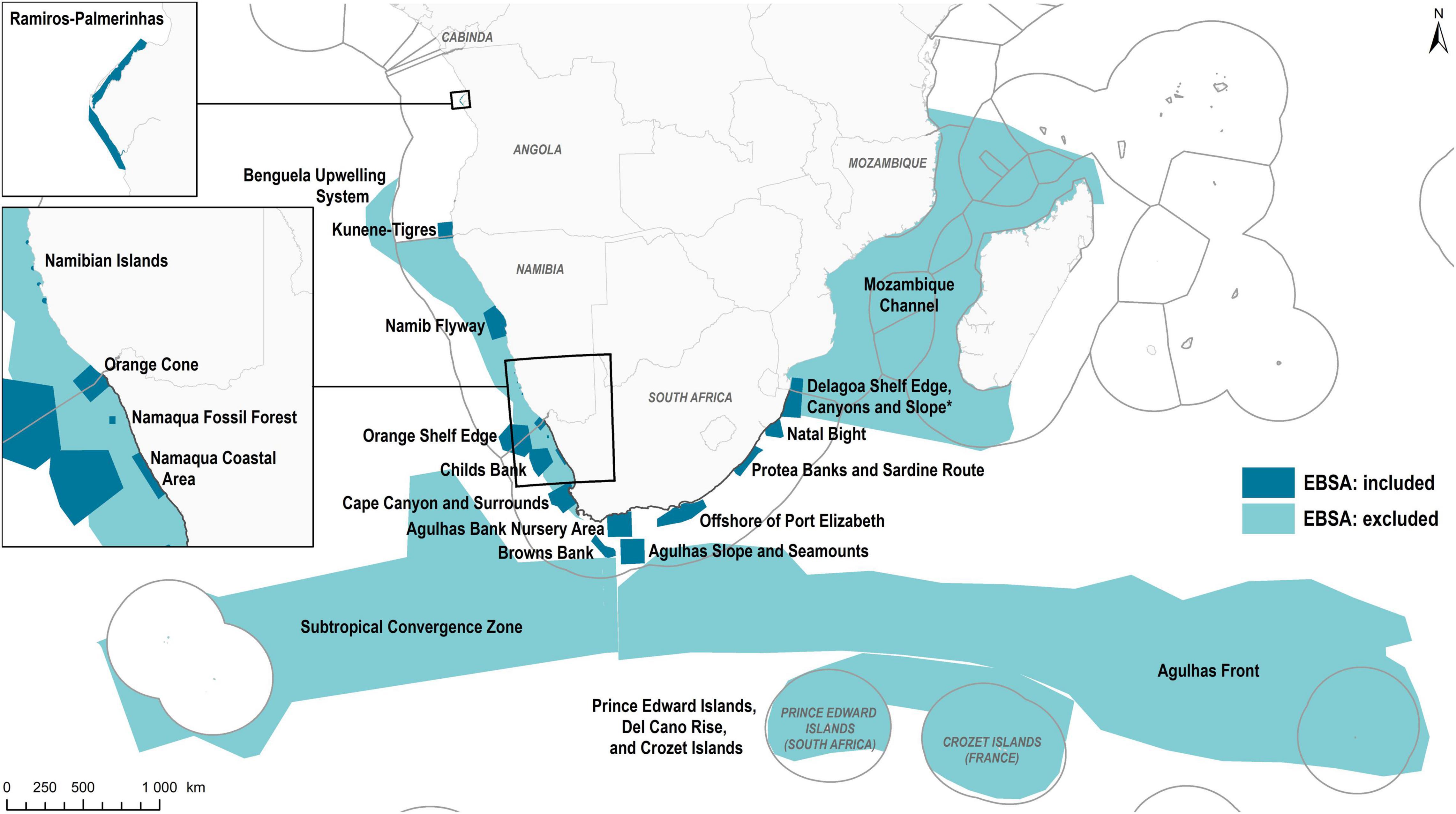
Figure 1. Study area, including the boundaries of the 22 original Ecologically or Biologically Significant Marine Areas (EBSAs) that lie wholly or partly within the marine territories of Angola (including the exclave, Cabinda), Namibia and South Africa (including the Prince Edward Islands). Those EBSAs that were included in the analysis are given in dark teal (n = 17), and those that were excluded in light teal (n = 5). Delagoa Shelf, Canyons and Slope is starred because the delineation was not revised, but a status assessment and proposed management for the South African portion of the EBSA was undertaken. Spatial data sources: EBSAs: www.cbd.int/ebsa; World Countries: ESRI (2015); Exclusive Economic Zones: Flanders Marine Institute (2018).
Refining Existing and Proposing New Ecologically or Biologically Significant Marine Areas in the Benguela Current Large Marine Ecosystem
The original EBSA boundaries were generic, often fairly geometric delineations of an approximate bounding box around the features for which the EBSA was described (Figure 1). Although this may be appropriate at a global scale, further refinement is required if the EBSAs are to be included in national-level, place-based ocean management. In addition, substantially more information and spatial data were available at the start of this project compared to that when the EBSAs were first proposed at the South East Atlantic and South Indian Ocean Regional Workshops (e.g., Harris et al., 2013, 2019a; Holness et al., 2014; Sink, 2016; Kirkman et al., 2019; Sink et al., 2019d). Not only could this contribute to more accurate delineations and updated descriptions, but also to describing new areas meeting the EBSA criteria. There are seven of these criteria: (1) Uniqueness or Rarity; (2) Special Importance for Life History Stages of Species; (3) Importance for Threatened, Endangered or Declining Species and/or Habitats; (4) Vulnerability, Fragility, Sensitivity, or Slow Recovery; (5) Biological Productivity; (6) Biological Diversity; and (7) Naturalness (CBD, 2008; UNEP-CBD, 2009). A site must rank “high” in at least one of these to be recognized as an EBSA.
Systematic conservation plans (Margules and Pressey, 2000) were run in Marxan (Ball et al., 2009) for Namibia and Angola (Holness et al., 2014; Kirkman et al., 2019) and South Africa (Sink et al., 2011; Majiedt et al., 2013). These are spatial prioritization analyses, designed to select portfolios of sites that adequately represent biodiversity pattern and processes (Moilanen et al., 2009). Full details on the plans are available in the references above. Briefly, the biodiversity input data included maps of ecosystem types, species distributions where available (e.g., key invertebrates and fish, seabirds, shorebirds, marine mammals, and turtles), important areas for key life-history stages of species (e.g., breeding areas, Important Bird and Biodiversity Areas), and other ecological processes. Priority areas were identified for meeting biodiversity targets by running Marxan. The finer-scale, more precise boundaries of the identified priority areas and underlying data (e.g., the specific features included in the plans) were then used to refine the coarse boundaries of existing EBSAs, based on their original descriptions (i.e., the narrative of why a site was being proposed) as a starting point [see also Harris et al. (2019b) for more details on how systematic conservation planning (SCP) can advance the EBSA description process]. In cases where priority areas were identified that did not overlap with existing EBSAs, these areas were researched to find available supporting information that could be used to evaluate the seven EBSA criteria. Those areas that did not meet the criteria or for which there was insufficient information available to support the site evaluation were excluded. Note that EBSAs are not the only mechanism for prioritizing areas for place-based management measures, so these areas can be accounted for in other mechanisms within the region—see sections “Proposing Ecologically or Biologically Significant Marine Area Zoning and Management Recommendations,” “Implementing Practical Management: Marine Protected Areas and Marine Spatial Planning,” and “Marine Protected Areas and Integration Into Marine Spatial Planning.” Those areas that did meet the criteria were retained and either included with current EBSAs where this was spatially sensible or described and delineated as a separate new EBSA. This process thus facilitated a systematic gap analysis of EBSAs at a national and regional scale, where all priority areas were evaluated as potential EBSAs.
The revised and new EBSA boundaries were also iteratively refined based on input at national workshops in each country, and at regional workshops, especially for the transboundary EBSAs. For example, following information-sharing sessions explaining EBSAs, experts provided additional information and justification to extend an EBSA to include the full extent of a feature, or split an existing EBSA into two new EBSAs to better reflect separate clusters of features that were more closely related. Further adjustments were also made based on other new datasets, e.g., South Africa’s updated Marine Ecosystem Map (Sink et al., 2019a) to ensure the delineations and descriptions were based on the best available science. The final EBSAs were technically reviewed nationally, regionally, and internationally with the assistance of experts from the Global Ocean Biodiversity Initiative (GOBI), who are also members of the CBD’s Informal Advisory Group on EBSAs. The EBSAs were then politically approved at the national, ministerial level to be sent to the CBD Secretariat and SBSTTA in 2020 (Namibia and South Africa) and 2021 (Angola; Figure 2).
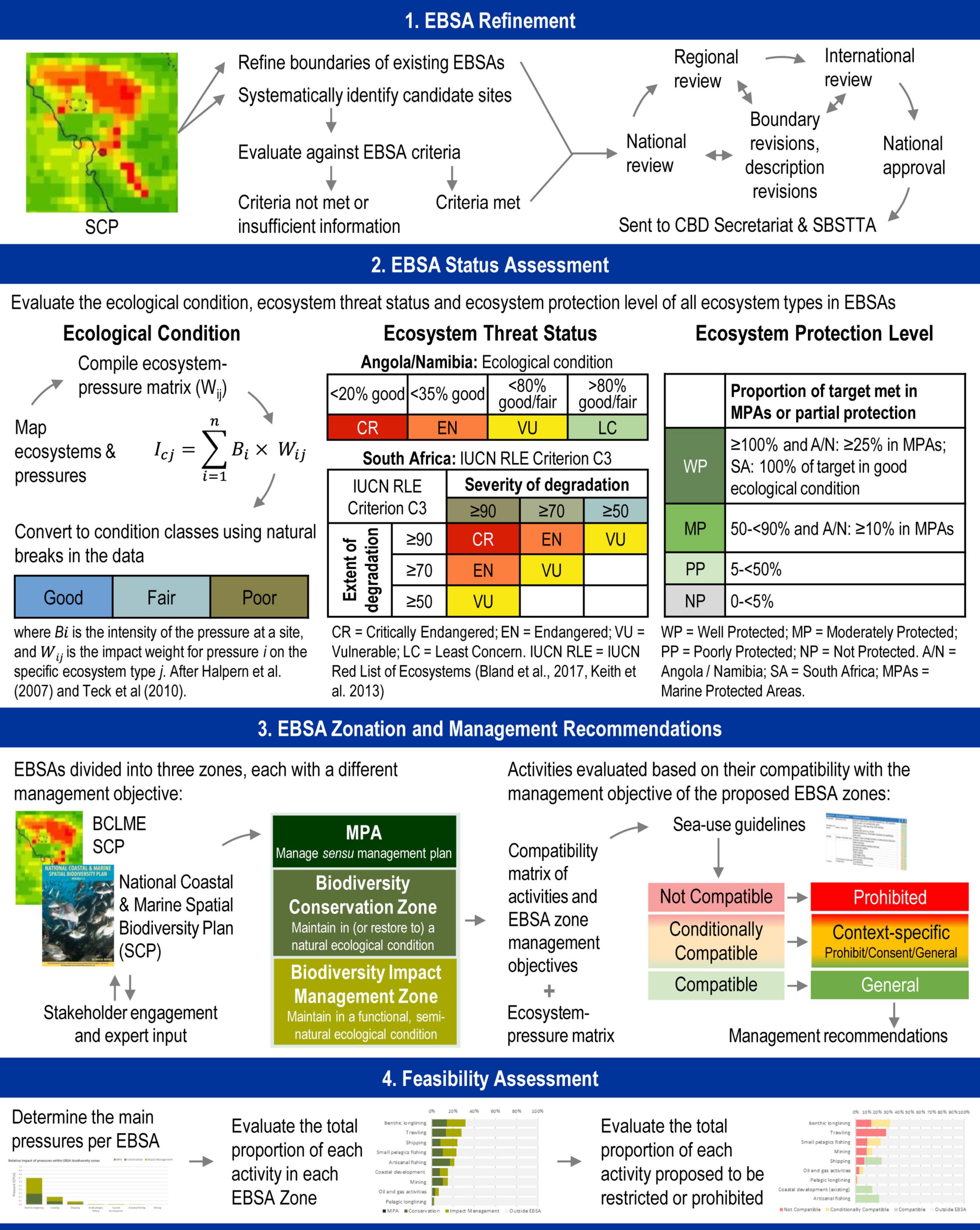
Figure 2. Overview of the methods used to refine EBSA boundaries, and descriptions assess the status of EBSAs, propose management recommendations, and review the feasibility of the management recommendations.
Assessing the Status of Ecologically or Biologically Significant Marine Areas
The status of EBSAs was assessed by quantifying three indicators: ecological condition; ecosystem threat status; and ecosystem protection level of the ecosystem types across the whole BCLME region, and summarizing the results within each EBSA. The proportion of each EBSA that is protected by MPAs or partially protected areas (e.g., exclusions of the major impacting fisheries) was also determined. Data underpinning these assessments are from Holness et al. (2014) and Kirkman et al. (2019) for Angola and Namibia, and from South Africa’s National Biodiversity Assessment 2018 (Majiedt et al., 2019; Sink et al., 2019a,b,c). Full details on the analyses are found in those references, but are described briefly below (see also Figure 2).
The assessment of ecological condition was based on a cumulative pressure assessment, adapted from the methods developed and used by Halpern et al. (2007) and Teck et al. (2010). Impact weightings based on the functional impact and recovery time of each pressure on each ecosystem group were scored by experts (e.g., impacts of demersal trawling on soft benthic shelf ecosystems). These impact weightings were multiplied by the intensity of the pressures at each site, and the values per site were then summed across all pressures. The data were split into three (four for South Africa) categories of ecological condition that represent areas in good, fair and poor ecological condition, on the premise that the higher the cumulative pressure per site, the poorer the ecological condition (Figure 2). The impact weightings for Namibia and Angola were based on those for South Africa (Sink et al., 2012), but were calculated at a coarser resolution given the differences in data resolution in the maps of ecosystem types for the different countries. For the purposes of these integrated analyses, the four categories of ecological condition in South Africa (Sink et al., 2019b) were simplified to match the three categories used for Angola and Namibia by grouping the Poor (Severely Degraded) and Very Poor (Very Severely Degraded) categories into a single “Poor” category.
Ecosystem threat status was calculated using different thresholds of ecosystem types in good ecological condition for Angola and Namibia (Holness et al., 2014; Kirkman et al., 2019), and using the criteria from the IUCN Red List of Ecosystems (RLE; Keith et al., 2013; Bland et al., 2017) for South Africa (Sink et al., 2019b). In the former case, Critically Endangered (CR) ecosystem types had < 20% of their extent in good ecological condition; Endangered (EN), < 35% of their extent in good ecological condition; and Vulnerable (VU), < 80% in good or fair ecological condition. Ecosystem types of Least Concern (LC) had > 80% of their extent in good or fair ecological condition (Figure 2). In the South African case, the IUCN RLE criterion C3 (ecosystem degradation, based on ecological condition) was used as the primary assessment, supplemented by an assessment of criterion B for ecosystem types with a restricted extent (Figure 2).
Ecosystem protection level was calculated slightly differently in Angola and Namibia (Holness et al., 2014; Kirkman et al., 2019) compared to that in South Africa (Sink et al., 2019c), although the results contain the same, broadly comparable categories of protection level. The biodiversity target for all ecosystem types was set at 20%, recognizing that recommendations since the analyses were undertaken are to have higher biodiversity targets, e.g., 30% (CBD, 2021). In Angola and Namibia, ecosystem types with 0- < 5% of their biodiversity target met in MPAs or areas with partial protection are considered Not Protected; 5- < 50% are Poorly Protected; 50- < 100% are Moderately Protected; and ≥ 100% are Well Protected. An additional rule was applied to the latter two categories: to qualify as Moderately Protected and Well Protected, respectively, ≥ 10% and ≥ 25% of the biodiversity target must be met in MPAs (not areas of partial protection), otherwise the ecosystem type was assigned one protection-level category lower down. In South Africa, the same categories and thresholds were applied as above, however, to qualify as Well Protected, the full target had to be met only in areas of good ecological condition. If this was not the case, then the ecosystem type was considered Moderately Protected (Figure 2).
From these analyses, the data were compiled in a simplified format to provide a clear summary of the key features of the EBSAs that could support site-specific decision-making (see sections ‘‘Proposing Ecologically or Biologically Significant Marine Area Zoning and Management Recommendations’’ and ‘‘Feasibility Assessment’’). A graphical summary (i.e., dashboard) was compiled per EBSA that included a brief overview of the EBSA, including the key features for which it was described. This was presented with a graphic of the seven EBSA criteria, using colors to indicate the relative importance of each criterion in the EBSA description. From the maps of ecological condition, ecosystem threat status, and ecosystem protection level, the following metrics were quantified per EBSA: the proportion in good, fair, and poor ecological condition; the proportion in each of the ecosystem threat status categories: CR, EN, VU, LC; and the proportion in MPAs or areas of partial protection. These were presented as pie charts next to a map of each of the three indicators. The relative contribution of each existing human activity to the cumulative pressure within each EBSA (and proposed EBSA Zones, see section ‘‘Proposing Ecologically or Biologically Significant Marine Area Zoning and Management Recommendations’’) was evaluated to identify the activities causing the most impacts, and was presented as a stacked bar chart. Therefore, in a single graphic, stakeholders could readily identify the key biodiversity features and key pressures per EBSA, which gave an indication of the kinds of management interventions that may be required to safeguard those biodiversity features. We also compiled posters of the EBSAs as another visual summary that were displayed at meetings, and full details, additional maps and data summaries were also available in the country technical reports, e.g., maps of individual activities and ecosystem-level statistics of the three indicators. All the information was posted on our EBSA Portal1 as well as the Benguela Current Convention’s (BCC) website2 so that the information was available in a variety of formats, including interactive maps and videos, for both biodiversity specialists and other stakeholders. In many cases, the content was continuously updated following meetings, feedback and revisions.
Proposing Ecologically or Biologically Significant Marine Area Zoning and Management Recommendations
After the EBSA boundaries had been refined, the EBSAs were zoned for inclusion in each country’s MSP process through an expert- and data-informed zoning process. There are three zones with slightly different names but the same characteristics across the three countries: (1) MPAs; (2) Biodiversity Conservation Zone (called “Biodiversity Zone: Conservation” in Angola and Namibia, and “Biodiversity Conservation Areas” in South Africa); and (3) Biodiversity Impact Management Zone (called “Biodiversity Zone: Impact Management” in Angola and Namibia, and “Biodiversity Impact Management Zone” in South Africa). For simplicity in this paper, we use the broader names hereafter.
Marine protected areas are formally gazetted and managed according to their management plans; therefore, those parts of EBSAs that are within MPAs will be managed as per those existing plans and regulations. The Biodiversity Conservation and Impact Management Zones, on the other hand, are proposed to be managed according to the management objectives drafted for those zones. For the Biodiversity Conservation Zone, the objective is to maintain the area in a natural to near-natural state, i.e., it is focused on achieving positive biodiversity outcomes, noting that in some cases this may require restoration. For the Biodiversity Impact Management Zone, the objective is to maintain the area in at least a functional state, i.e., maintain reasonable levels of biodiversity function (including ecological processes) within a multi-use space and context. In Angola and Namibia, the EBSA zonation was an interactive process, informed by the systematic conservation plans (Holness et al., 2014; Kirkman et al., 2019), dashboards, and stakeholder and expert input to derive the zones listed above (Figure 2). In South Africa, the zonation was based on the National Coastal and Marine Spatial Biodiversity Plan (NCMSBP; Harris et al., 2021), which was underpinned by a systematic conservation plan with stakeholder and expert input (Figure 2). The NCMSBP includes a map of MPAs, Critical Biodiversity Areas (CBAs), and Ecological Support Areas (ESAs) across South Africa’s entire mainland EEZ, with CBAs and ESAs, respectively, having the same management objectives as the EBSA Biodiversity Conservation Zone and Biodiversity Impact Management Zone. Therefore, in addition to the existing MPAs, the CBAs and ESAs were used as the basis for EBSA zoning in South Africa. Development of the sea-use guidelines for the NCMSBP and EBSA zones was an integrated process, such that these guidelines are identical in both cases.
Ecologically or Biologically Significant Marine Area management recommendations depend on the compatibility of an activity with the management objective of the zone. Management of activities in MPAs is done according to their management plans and gazetted regulations, and therefore the analysis was restricted only to the parts of EBSAs that are outside of MPAs. All ocean-based activities were tabulated for each of the three countries, and evaluated against the management objective of each EBSA zone to determine whether they are Compatible, Conditionally Compatible, or Not Compatible based on the extent and severity of impact of those activities (Figure 2). This was done iteratively in national workshops, guided by the ecosystem-pressure matrices for Angola, Namibia (Holness et al., 2014), and South Africa (Sink et al., 2019b), the dashboards, and with additional stakeholder input. There were also regional transboundary meetings to align management recommendations for activities per country in shared EBSAs. The concomitant management recommendations are that activities that are Not Compatible with the management objective of an EBSA zone are not permitted (i.e., Prohibited); and Compatible activities are permissible according to general rules that govern those activities (i.e., General; Table 1). Conditionally Compatible activities require a site-specific, context-specific analysis to determine the appropriate management recommendation for that particular place. Activities in this category could be: Prohibited; permitted subject to careful controls and regulations (i.e., Consent); or General, depending on the biodiversity features for which the site was prioritized and the severity of impact of the activity on those features (Table 1). Note that the sea-use guidelines for Angola and Namibia were more place-specific than in South Africa, with separate (although largely similar) tables created per EBSA, vs. a single table created for all EBSAs in South Africa (which comes from the NCMSBP). Although, more recent versions of the sea-use guidelines for Namibia have followed the aligned guidelines for all transboundary EBSAs. It is also worth noting that the regulatory approach proposed for the respective zones stems from land-use planning traditions, and hence corresponds with the established spatial planning and management approaches in the three countries.
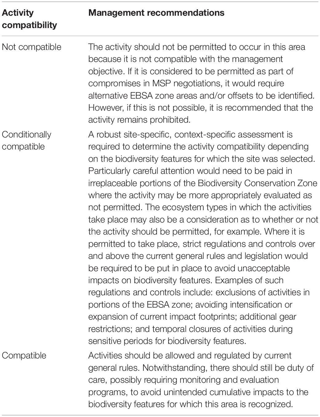
Table 1. Management recommendations for activities based on their compatibility with the management objective of the Ecologically or Biologically Significant Marine Area (EBSA) zones (see also part 3 of Figure 2).
Feasibility Assessment
A rapid feasibility assessment was undertaken by systematically evaluating all activities that take place in each EBSA, and analyzing the impacts that the proposed zonation and management recommendations would have on those activities (see Table 1). The proportion of each activity in the proposed EBSA zones (MPA, Biodiversity Conservation Zone, Biodiversity Impact Management Zone) and activity-compatibility classes (Compatible, Conditionally Compatible, Not Compatible) was determined as a proportion of that activity’s national footprint. Note that the calculations were based on the relative intensity of the activity rather than only the spatial extent to give a better indication of the relative value of a site to each industry. For example, recommending prohibition of fishing in an intensively fished area has a higher impact to that fishery than if it were infrequently fished. In Namibia, a more formal rapid Strategic Environmental Assessment (SEA) is being done in the central MSP area to evaluate the impact of the draft central marine spatial plan with its proposed zones and regulations.
Implementing Practical Management: Marine Protected Areas and Marine Spatial Planning
Due to the integrated nature of MSP, the cross-sector coordination inherent to SCP, and the chosen approach to EBSAs, the MSP and EBSA processes were closely interwoven throughout all steps taken. Integration was achieved through vertical coordination between regional and national levels, and horizontally within and between governments by means of formally established inter-ministerial expert structures leading the technical and scientific implementation (Figure 3; Finke et al., 2020a). Given that the BCLME countries have a relatively long history of multi-sector cooperation aimed at regional and national cross-sector coordination (de Barros Neto et al., 2016; Hamukuaya et al., 2016; Naidoo et al., 2021), two Regional Working Groups (RWGs)—one on MSP and the other on EBSAs—were established in 2016 under the BCC. The groups comprise up to five government officials from each country that represent each of the key sector ministries/departments: fisheries, mining, petroleum, transport, and environment.

Figure 3. Relationships within the MARISMA Project, showing how all components are connected. The GIZ MARISMA Project provides project management and technical support to the EBSA and MSP workstreams at all levels and across all BCLME countries. Within each workstream, the Regional Working Groups (RWGs) and National Working Groups or Task Teams (NWGs) all engage with each other in collective learning, including across Workstreams.
In addition to these regional-level structures, inter-ministerial National Working Groups (NWGs), encompassing all relevant sector ministries/departments and academic institutions, were put in place around the same time by each of the BCLME countries to support the introduction of MSP and drive plan preparation. Additionally, EBSA country teams were established, either as a specialized sub-group under the MSP NWGs or using existing committees, to lead the SCP processes nationally and support it regionally. Most RWG members are also engaged in the national-level MSP and EBSA processes and are part of the MSP and EBSA NWGs. Nationally and regionally, civil society and technical experts provided advice and input. The organization of the process as a collaborative effort with inter-ministerial structures across sectors and countries enabled a direct integration of the results of the EBSA work into MSP and marine management measures. As such, the SCP-informed EBSA process was a dedicated sub-process to MSP from the outset (Finke et al., 2020b). This enabled an interactive development across technical teams nationally and regionally, and provided for an iterative validation process of the outputs (e.g., through formal and informal consultations and workshops, or joint working group meetings) for eventual integration into MSP decision-making. Further, the EBSA work laid the foundation for progress toward MPA designations.
Distilling Lessons Learned
A survey was circulated among those who have been participating in the national- and regional-level processes, supported by the MARISMA Project (i.e., all NWGs and RWGs of both the EBSA and MSP workstreams), to get feedback on the lessons learnt through the process. The responses (n = 14) were grouped into similar themes and overarching lessons were distilled for projects that intend to progress from EBSAs (or similar spatial biodiversity prioritizations) to practical management, e.g., MSP, MPAs or other place-based actions. These lessons are outlined in the Discussion.
Results
Revised Ecologically or Biologically Significant Marine Areas in the Benguela Current Large Marine Ecosystem
Originally, there were 17 EBSAs in Angola, Namibia and South Africa that were included in the analyses. Of these, the boundary was refined for 14 EBSAs, two were each split into two more refined EBSAs, 10 new EBSAs were described, and Delagoa Shelf Edge, Canyons and Slope was unchanged (Figure 4). Therefore, the total number of EBSAs in the three countries after the revisions is 29 (Figure 4). The EBSA descriptions and some of the EBSA names were also revised, and the criteria re-evaluated based on new evidence, previously overlooked research, and the new spatial extents. There were 25 criterion rank changes for 12 EBSAs (Table 2 and Figure 5), of which 21 changes were upgrades (e.g., Medium to High) and the remaining four were downgrades (e.g., Medium to Low). Most EBSAs had only 1–3 rank changes, except for Mallory Escarpment and Trough, which had six (three upgrades and three downgrades). This EBSA was one of two revised EBSAs that came from the original Agulhas Slope and Seamounts EBSA, the other revised EBSA being Shackleton Seamount Complex. The primary area and features for which Agulhas Slope and Seamounts was described were similar to those for Shackleton Seamount Complex, but different for Mallory Escarpment and Trough, hence why the original EBSA was split, and why so many criterion rank changes were required in that case. Overall, rank changes were made across all seven criteria, with most changes to the Naturalness criterion (n = 8), Uniqueness and Rarity criterion (n = 6), and Biological Diversity criterion (n = 4; Figure 5). The changes in the Naturalness ranks indicate in part the EBSA refinement process, which focused on including the core remaining natural and near-natural portions of features as far as possible, resulting in an upgrade of the rank (Table 2 and Figure 5). Overall, the rank changes also reflect the more systematic approach taken across the region, and the efforts to standardize and align ranks across EBSAs, often based on actual spatial data (e.g., maps of ecological condition and ecosystem types) in the absence of formal definitions of or thresholds for each EBSA criterion rank. On a process level, sending the refined and new EBSAs to the CBD Secretariat and SBSTTA reflects the robust nature of the processes and the political support for this evidence-based scientific and technical exercise that was undertaken.
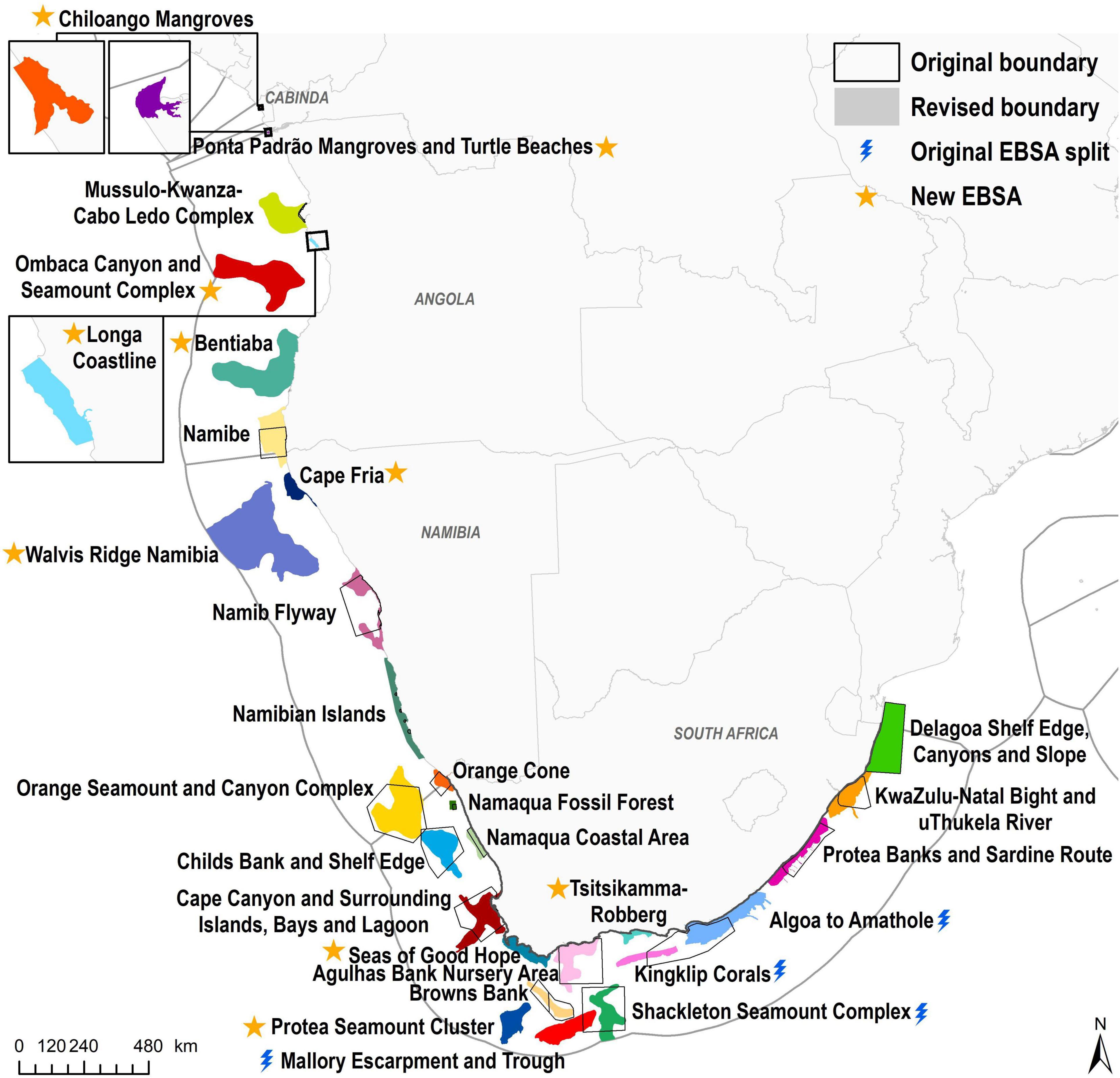
Figure 4. Revised Ecologically or Biologically Significant Marine Areas (EBSAs) in Angola, Namibia, and South Africa. For some EBSAs, the original boundary (black outline, see Figure 1) was refined (colored polygons), some original EBSAs were split into two (blue bolt), and in other cases, new EBSAs were described (yellow star). The boundary of Delagoa Shelf Edge, Canyons and Slope remains unchanged. Zoomed inserts are included for EBSAs that are too small to be visible at the scale of the primary map. Spatial data sources: Original EBSAs: www.cbd.int/ebsa; Revised EBSAs: this project; World Countries: ESRI (2015); Exclusive Economic Zones: Flanders Marine Institute (2018).
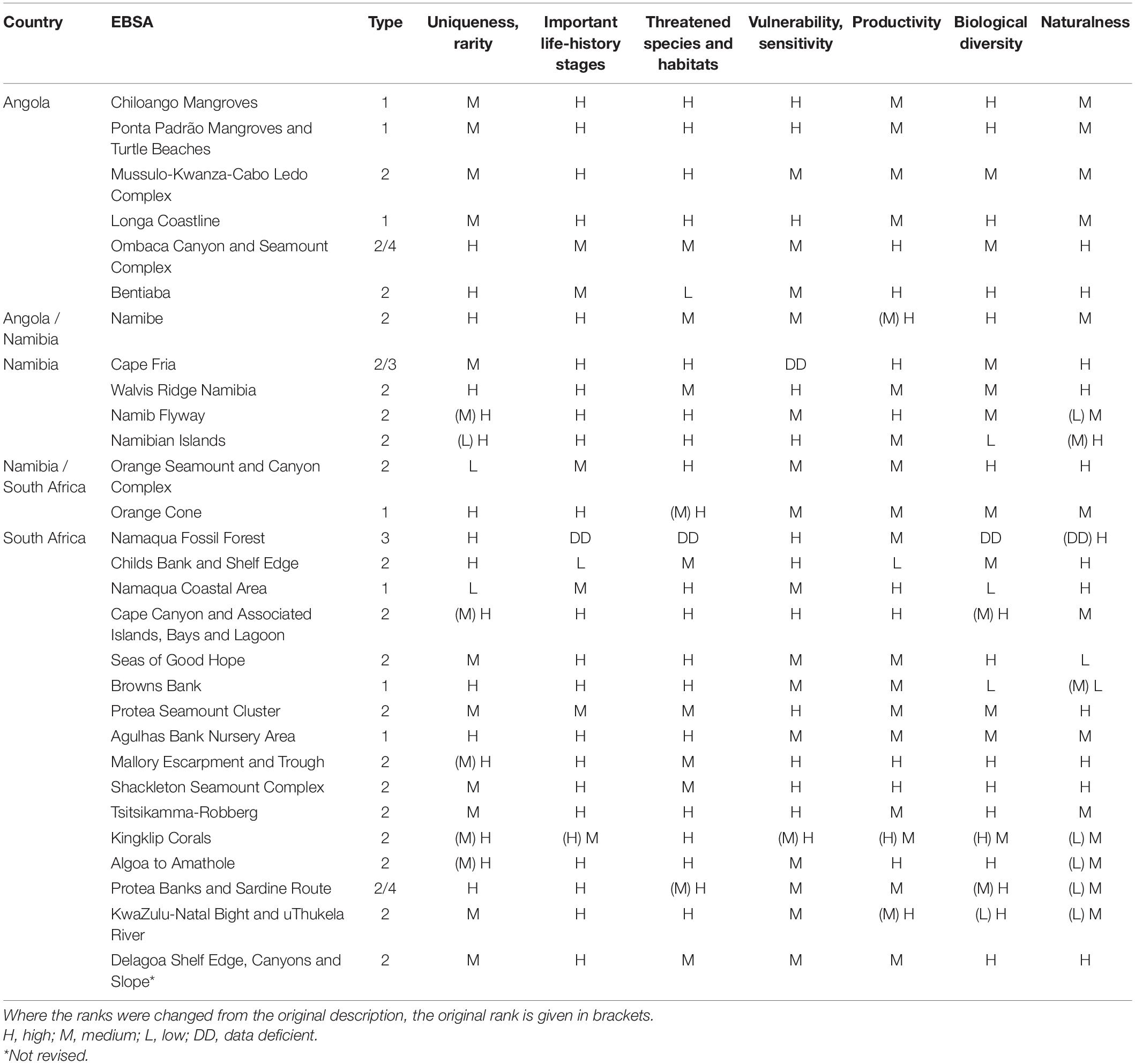
Table 2. List of Ecologically or Biologically Significant Marine Areas (EBSAs) per country, including transboundary EBSAs shared between countries, their EBSA Type (sensu Johnson et al., 2018), and ranking for each of the seven EBSA criteria.
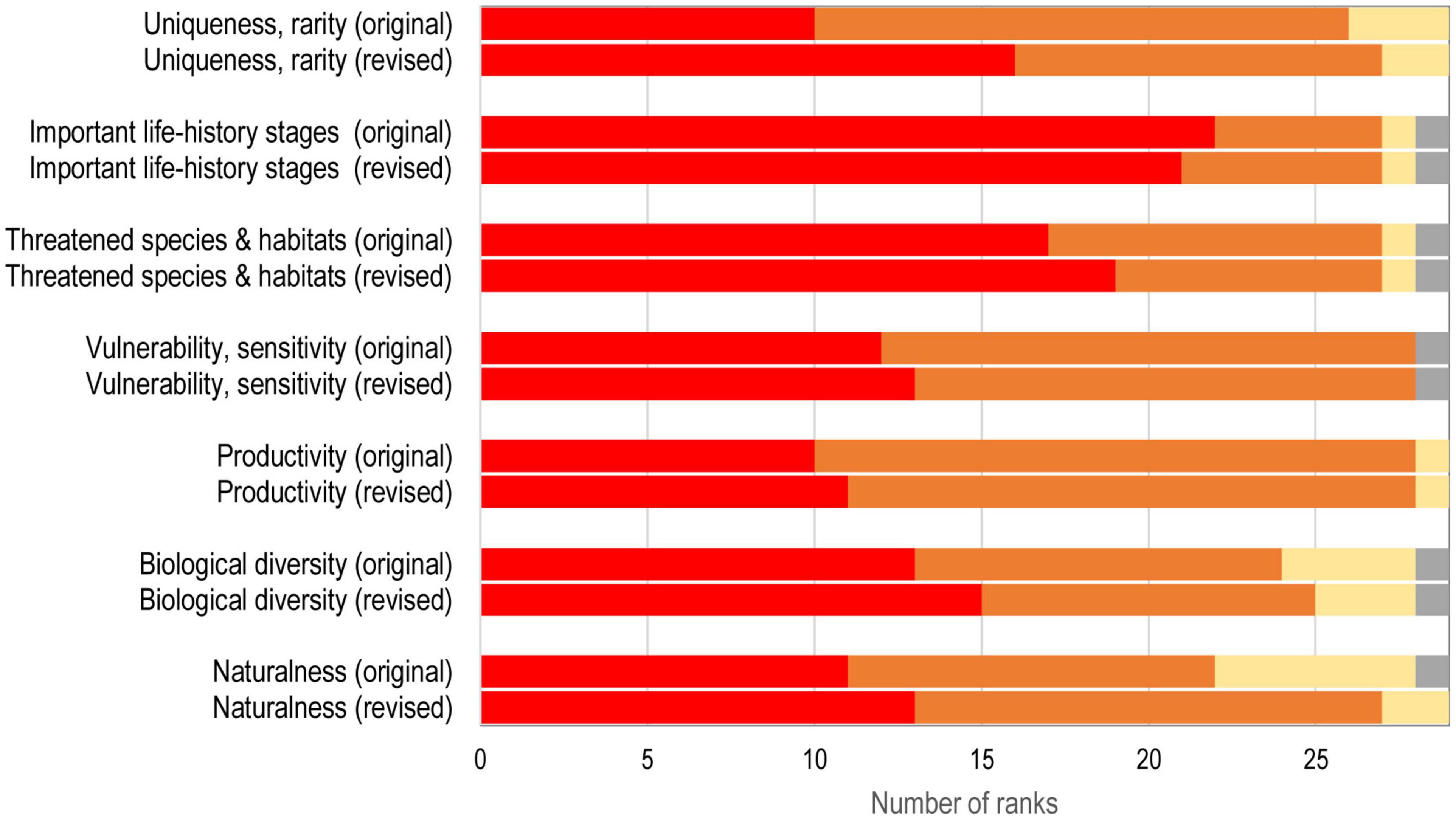
Figure 5. Changes in criteria ranks from the original to revised Ecologically or Biologically Significant Marine Area (EBSA) descriptions. Note that the ranks for the new EBSAs were included in both the original and revised categories. Red, High criterion rank; Orange, Medium; Yellow, Low; Gray, Data Deficient.
Ecologically or Biologically Significant Marine Area Status
The average EBSA extent that is in good ecological condition is 55.6% ± 32.9 SD (standard deviation). The remaining portions are split equally between fair ecological condition: 21.6% ± 17.1 SD, and poor ecological condition: 21.9% ± 27.1 SD (Figure 6). Generally, EBSAs closer to the coast tend to have higher proportions of area in poor ecological condition compared to those further offshore. Ombaca Seamount and Canyons Complex and Protea Seamount Cluster were assessed as having the best ecological condition (100.0% good), and Ponta Padrão Mangroves and Turtle Beaches were assessed as having the worst ecological condition (85.0% poor). (Any discrepancies in totals here and below are due to rounding).
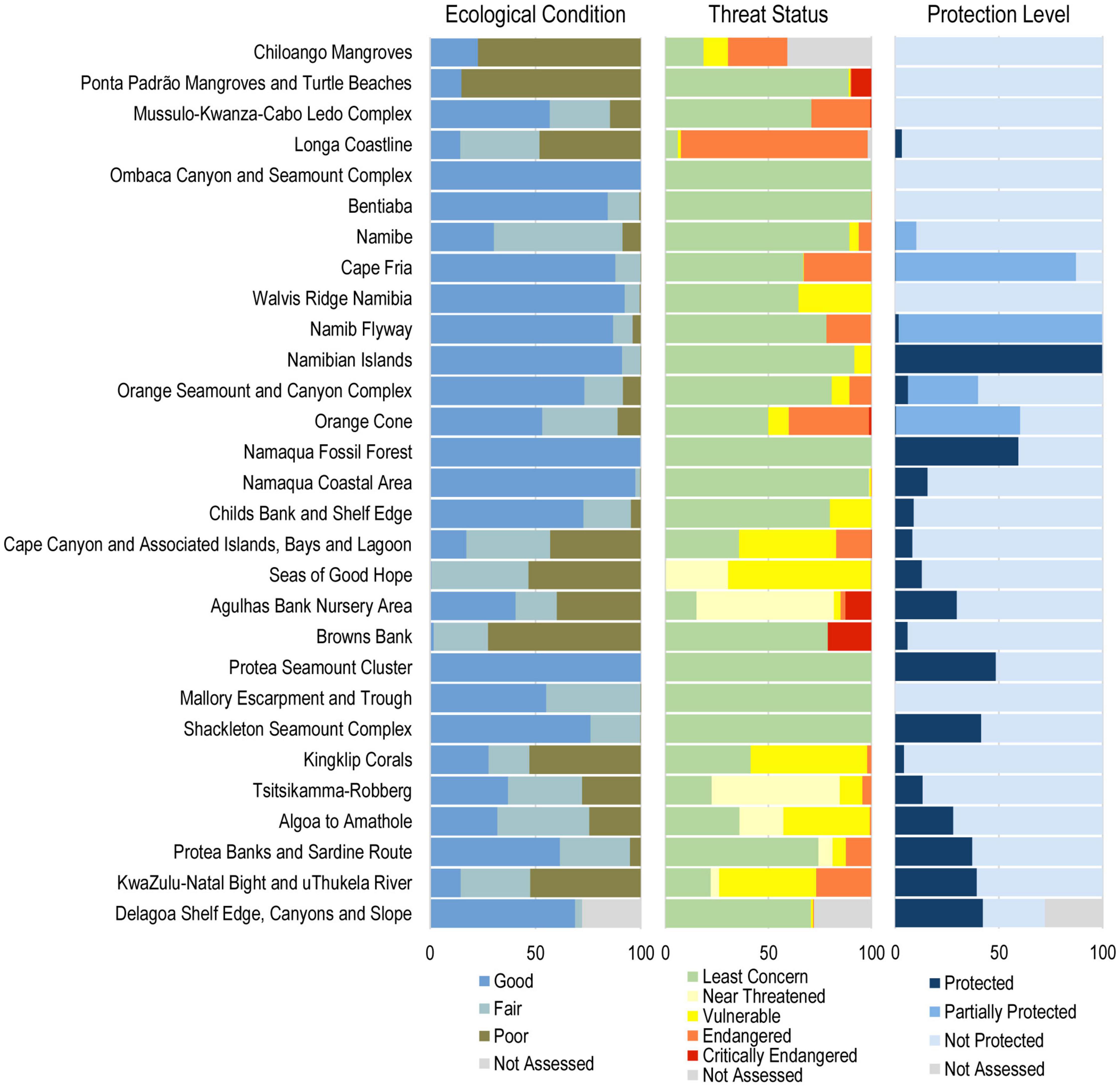
Figure 6. The proportion of each Ecologically or Biologically Significant Marine Area (EBSA) in the different categories of ecological condition, ecosystem threat status, and ecosystem protection level, with the most desirable categories on the left, and the least desirable categories on the right of all three panels. Portions of EBSAs that were “Not Assessed” include those on land (e.g., mangroves) or in countries outside of the study area (e.g., Mozambique). Note that some protection for coastal EBSAs may come from land-based protected areas. EBSAs are arranged from top to bottom approximately north to south and west to east (see Figure 4).
Only five EBSAs do not include threatened ecosystem types. These are all offshore EBSAs: Ombaca Canyon and Seamount Complex; Namaqua Fossil Forest; Protea Seamount Cluster; Mallory Escarpment and Trough; and Shackleton Seamount Complex. Longa Coastline has the highest proportion of threatened ecosystem types, at 92.2%. On average, the proportion of EBSA extent that comprises threatened ecosystem types is 26.1% ± 25.8 SD, mostly in the Vulnerable (13.3% ± 20.1 SD) and Endangered (11.2% 19.5 SD) categories (Figure 6). Critically Endangered ecosystem types make up 1.6% ± 4.8 SD of the EBSAs, Near Threatened ecosystem types make up 6.6% ± 17.4 SD (assessed only in South Africa), and Least Concern ecosystem types make up the remaining 64.9% ± 32.6 SD (Figure 6).
Twenty-three EBSAs have at least some portion of their extent in an MPA or partially protected area. This is not by chance in South Africa because the analyses underpinning the original EBSAs, revised EBSAs, and declaration of 20 new MPAs in 2019 were all based on the same priority features for marine biodiversity (see section “Marine Protected Areas and Integration Into Marine Spatial Planning”). The remaining six EBSAs have no formal protection in MPAs (although a few have some fisheries management measures in place, e.g., a fishery closure or exclusion from shallower areas). These are: Chiloango Mangroves; Ponta Padrão Mangroves and Turtle Beaches; Ombaca Seamount and Canyon Complex; Bentiaba; Walvis Ridge Namibia; and Mallory Escarpment and Trough. The average extent of EBSAs in MPAs is 17.5% ± 23.9 SD; in partially protected areas is 10.0% ± 26.1 SD; and with no protection is 71.6% ± 31.3 SD (Figure 6).
The relative contribution of the different activities to cumulative pressure on biodiversity within EBSAs was variable and site-specific, depending on characteristics such as proximity of the EBSA to shore, and the number and intensity of activities present. However, with few exceptions, the main activities causing the most pressure on individual EBSAs were various fisheries and shipping. Key pressures in some of the coastal EBSAs also included activities such as coastal development, and guano and mariculture activities. An example dashboard comprising summary results for this cumulative pressure analysis and that of the three status indicators described above is given for Mussulo-Kwanza-Cabo Ledo in Angola (Figure 7).
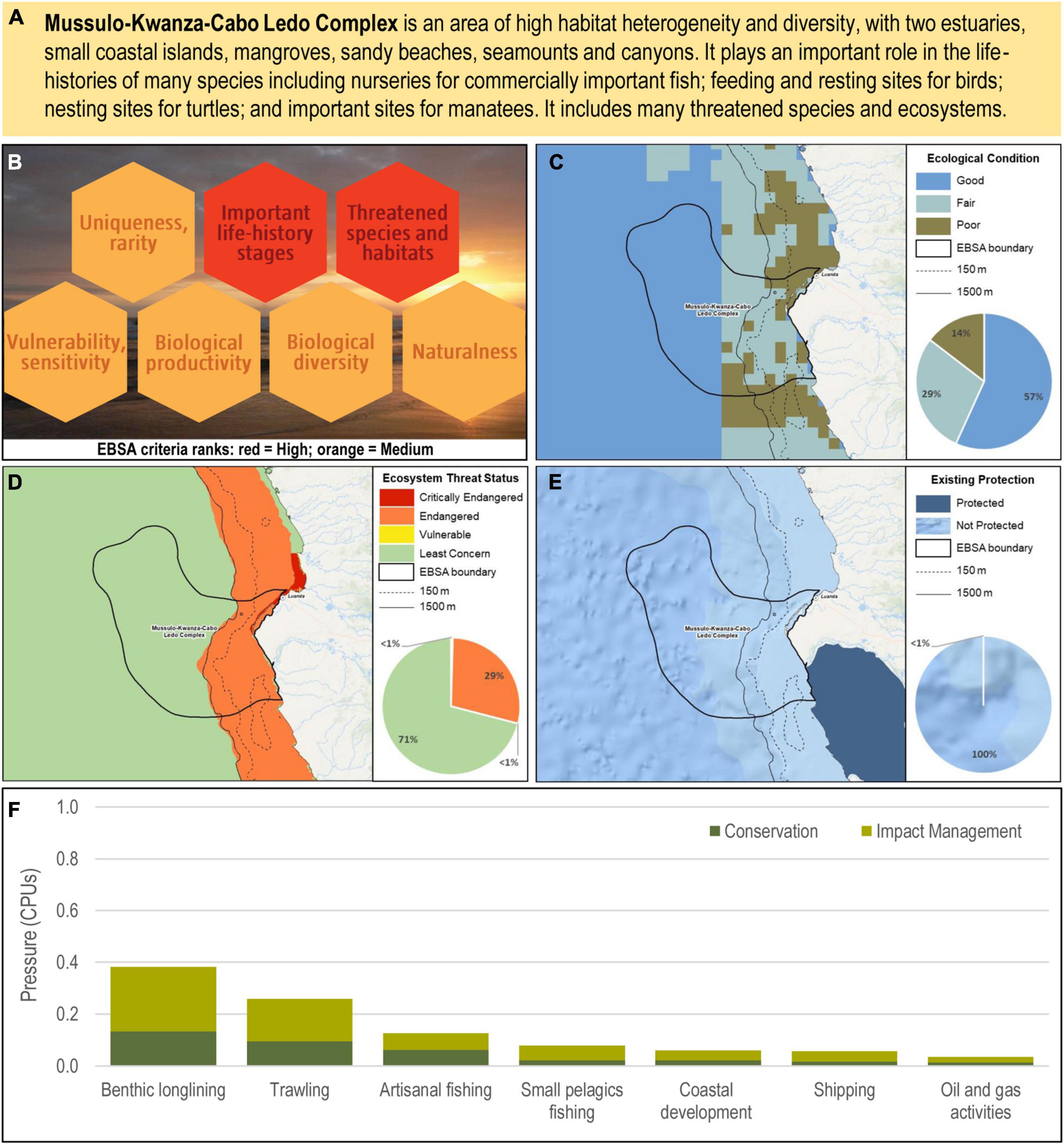
Figure 7. Dashboard for Mussulo-Kwanza-Cabo Ledo Complex as an example of what was generated per EBSA. The dashboard includes: (A) the key biodiversity features for which the EBSA was described; (B) EBSA criteria ranks indicating the key criteria for which the EBSA is recognized; (C) ecological condition, (D) ecosystem threat status, and (E) existing protection within the EBSA; and (F) the pressure (in arbitrary cumulative pressure units, CPUs) summed for each pressure in the EBSA, per proposed EBSA biodiversity zone, ranked left (highest) to right (lowest) by the overall relative importance of pressures in this EBSA, indicating the relative impact of activities within the EBSA zones. Note that pressures comprising < 1% of the EBSA pressure profile are not shown, and that there are no Marine Protected Areas (MPAs) in this example. Conservation, Biodiversity Conservation Zone; Impact Management, Biodiversity Impact Management Zone.
EBSA Zoning and Management Recommendations
Ecologically or Biologically Significant Marine Areas were divided into three zones: (1) MPAs; (2) Biodiversity Conservation Zone; and (3) Biodiversity Impact Management Zone (Figure 8). Sixteen EBSAs comprise all three zones; and 13 EBSAs comprise two zones: Biodiversity Conservation Zone and Biodiversity Impact Management Zone. Although the full extent of the Namibian Islands EBSA is an MPA, it is included in the latter group because the two zones were created to support MPA zoning. Apart from Namibian Islands, all EBSAs that contain MPAs are in South Africa. Again, as noted previously, this is not a coincidence because the EBSA and recent MPA expansion processes were all based on the same data sets and priority areas for marine biodiversity (see section “Marine Protected Areas and Integration Into Marine Spatial Planning”). The average proportion of EBSAs in the three zones are 17.7% (± 24.6 SD) MPA, 42.2% (± 27.8 SD) Biodiversity Conservation Zone, and 39.9% (± 22.1 SD) Biodiversity Impact Management Zone.
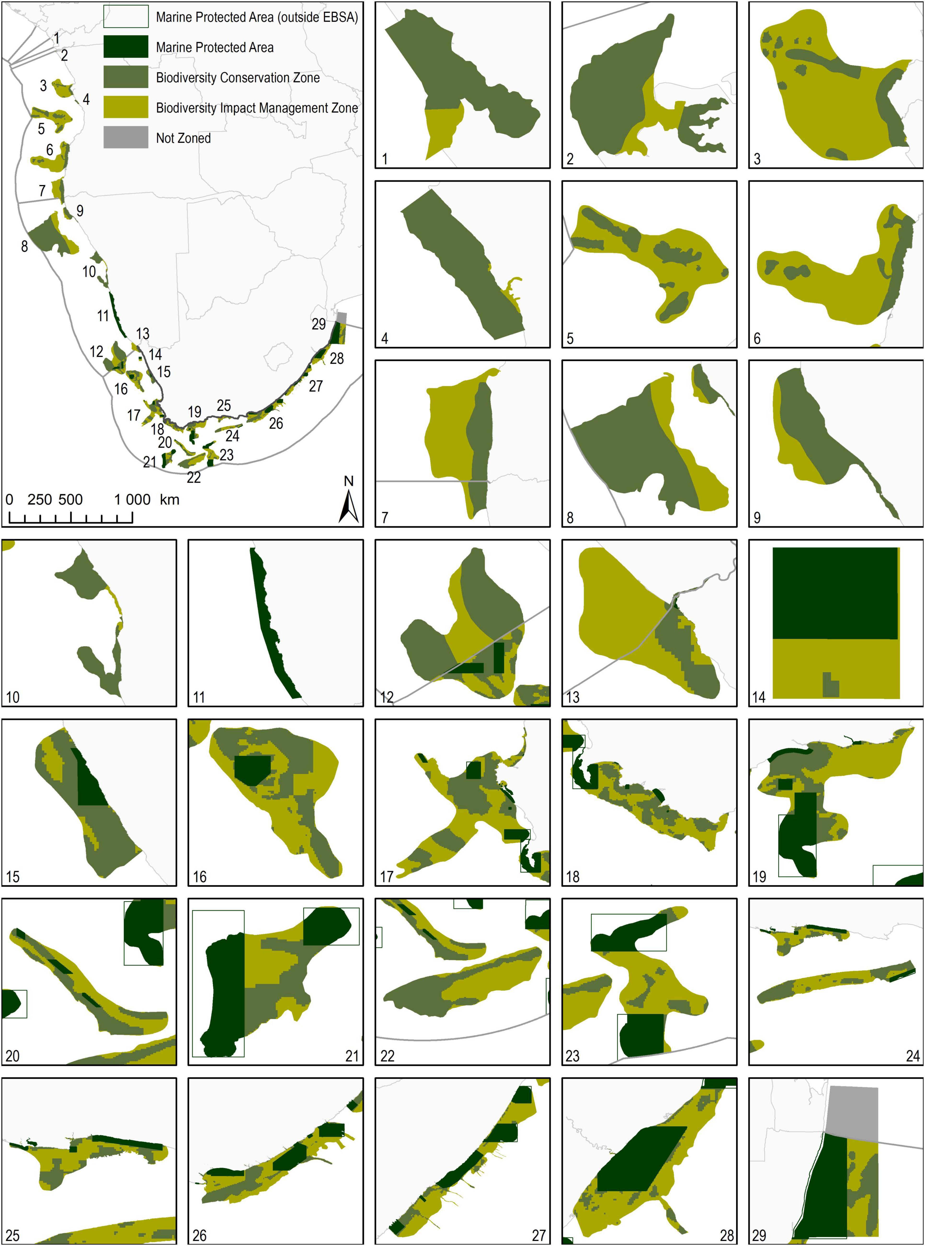
Figure 8. Proposed zonation of Ecologically or Biologically Significant Marine Areas (EBSAs). There are three zones: MPAs (dark green); Biodiversity Zone: Biodiversity Conservation Zone (medium green); and Biodiversity Impact Management Zone (light green). EBSAs are numbered from north to south, west to east, with zoomed inserts numbered by EBSA. 1, Chiloango Mangroves; 2, Ponta Padrão Mangroves and Turtle Beaches; 3, Mussulo-Kwanza-Cabo Ledo Complex; 4, Longa Coastline; 5, Ombaca Canyon and Seamount Complex; 6, Bentiaba; 7, Namibe; 8, Walvis Ridge Namibia; 9, Cape Fria; 10, Namib Flyway; 11, Namibian Islands; 12, Orange Seamount and Canyon Complex; 13, Orange Cone; 14, Namaqua Fossil Forest; 15, Namaqua Coastal Area; 16, Childs Bank and Shelf Edge; 17, Cape Canyon and Associated Islands, Bays and Lagoon; 18, Seas of Good Hope; 19, Agulhas Bank Nursery Area; 20, Browns Bank; 21, Protea Seamount Cluster; 22, Mallory Escarpment and Trough; 23, Shackleton Seamount Complex; 24, Kingklip Corals; 25, Tsitsikamma-Robberg; 26, Algoa to Amathole; 27, Protea Banks and Sardine Route; 28, KwaZulu-Natal Bight and uThukela River; 29, Delagoa Shelf Edge, Canyons and Slope. Spatial data sources: revised EBSAs: this study; World Countries: ESRI (2015); Exclusive Economic Zones: Flanders Marine Institute (2018); South African Marine Protected Areas: Republic of South Africa (2019).
The activities that make up the sea-use guidelines in all three countries range from recreation and ecotourism, through various forms of resource extraction, to various transport-related activities, with different levels of nuance in how detailed the activity splits are among countries. As a result, the sea-use guidelines comprise a different number of activities in Angola (n = 61), Namibia (n = 38) and South Africa (n = 48). Ocean-based activities generally cause some level of ecological degradation. Therefore, most activities are Not Compatible or Conditionally Compatible with the management objective of the Biodiversity Conservation Zone: to maintain the site in a natural to near-natural state. Only some activities are Compatible with it, e.g., beach recreation. For the Biodiversity Impact Management Zone, many more activities are Compatible or Conditionally Compatible with the management objective to maintain the site in at least a functional state, and only a few are Not Compatible, e.g., ammunition dumping. In some cases, stricter management recommendations (i.e., prohibitions) apply only to new activities, e.g., in Angola, construction of new ports in the Biodiversity Conservation Zone is considered Not Compatible, and is thus recommended to be Prohibited. This was to avoid unreasonable or even unrealistic recommendations, such as termination of an existing port or removal of other well-established infrastructure or coastal development. The sea-use guidelines for the Angolan portion of Namibe are given as an example (Table 3). Note that the guidelines are presented in both English and Portuguese; the latter is the official language in Angola.
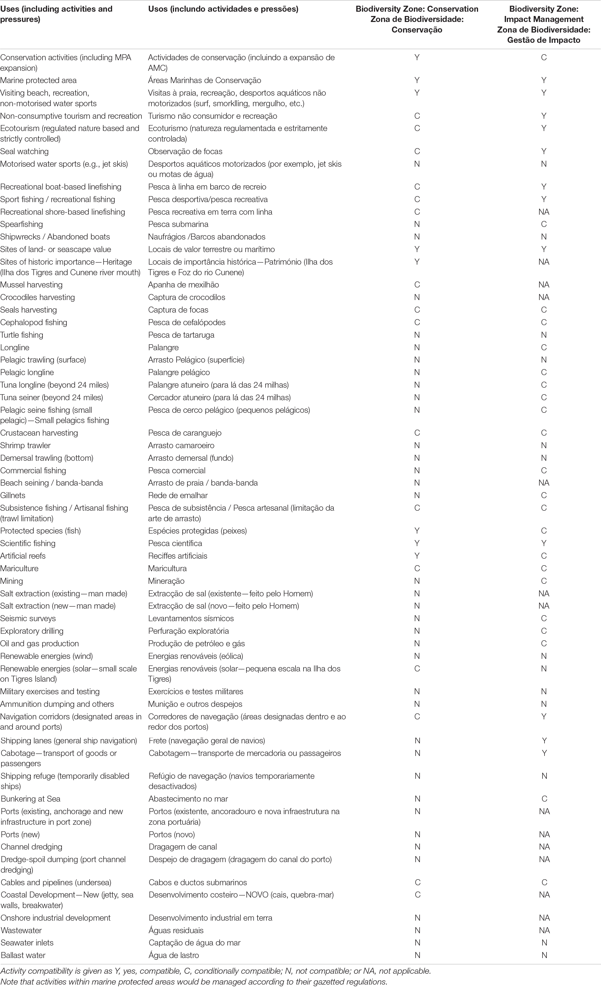
Table 3. List of all sea-use activities in the Angolan portion of the Namibe EBSA, scored according to their compatibility with the management objective of the Biodiversity Conservation Zone and Biodiversity Impact Management Zone, and given in both English and Portuguese (the official language of Angola).
Feasibility Assessment
Where management decisions are made on a site-specific basis (e.g., within each EBSA separately rather than across all EBSAs), the graphs of the relative proportion of cumulative pressure on the biodiversity within each EBSA can be very useful (Figure 7F). This is especially true when viewed in the context of the site, e.g., reasons for selection as an EBSA, ecological condition, ecosystem threat status, ecosystem protection level, and key biodiversity features (Figures 7A–E). However, the cumulative effect of management decisions at the national scale (Figure 9) must also be part of the considerations when entering MSP processes and negotiations. The extent of the proposed prohibitions and restrictions on activities must be reasonable to require of those sectors, otherwise the risk is that the entire proposal will be dismissed and rejected outright. Where substantial portions of an activity are proposed to be Prohibited or Restricted, there needs to be a robust justification as to why that is the case. Therefore, the management recommendations must be evidence based in terms of being a legitimate and robust requirement based on the sensitivity of the specific biodiversity feature(s) to impacts from an activity, and feasible in terms of the consequences for or impacts on a sector. Across all three countries, apart from a few exceptions, generally less than a third of each activity is proposed to have some level of restriction (Conditionally Compatible). Prohibitions are recommended in some areas for a few of the more habitat-destructive activities, such as trawling and mining (Figure 9). The level of proposed prohibitions ranges 15–59% of activities in the Biodiversity Conservation Zone, and 0–24% in the Impact Management Zone across the three countries.
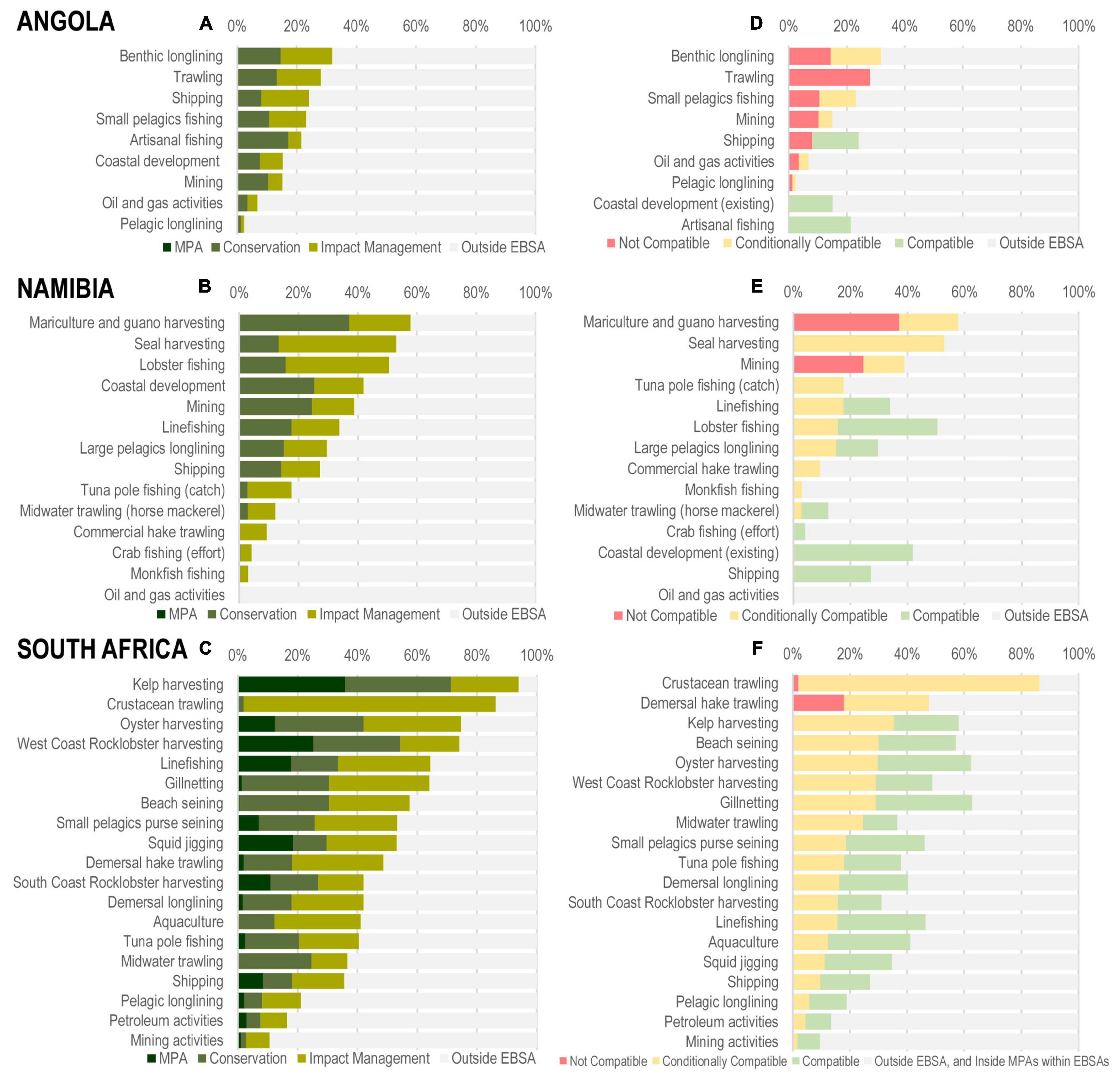
Figure 9. (A–C) Proportion (%) of activity intensity in each of the proposed EBSA zones: Marine Protected Areas (MPAs), Biodiversity Conservation Zone (Conservation) and Biodiversity Impact Management Zone (Impact Management), compared to that outside of EBSAs, sorted from highest to lowest proportion of the activity intensity within the EBSA footprint. (D–F) Proportion (%) of activity intensity that is in each of the EBSA management categories after applying each country’s sea-use guidelines, sorted from highest to lowest proportion of proposed restrictions (sum of proportions in the not compatible and conditionally compatible categories). See Table 1 for detailed explanations of the categories. Figures are for (A,D) Angola, (B,E) Namibia, and (C,F) South Africa).
Marine Protected Areas and Integration Into Marine Spatial Planning
The EBSA process led to the identification of areas proposed to be designated as MPAs, some of which have already been proclaimed. Angola is currently in the process of turning all of its EBSAs (either wholly or partially) into MPAs. This process will begin with the designation of its first MPA based on the EBSA delineation and zoning process covering the Angolan parts of the Namibe EBSA that is shared with Namibia. The Namibian government has committed to strengthening protection levels in line with international targets (e.g., New Era, 2019), and the set of new, updated EBSAs provides a solid basis to inform such processes. In South Africa, 20 new MPAs were declared in 2019, all of which overlap wholly or partly with EBSAs (Figure 10C). The overlap between South Africa’s MPAs and EBSAs was strengthened during the EBSA revision process (section “Revised Ecologically or Biologically Significant Marine Areas in the Benguela Current Large Marine Ecosystem”; Figure 10C). This is not by chance, because both processes share the same underlying datasets and recognize the same key features as biodiversity priority areas. The EBSA revision process has incorporated some of the new information that was generated during the MPA process, hence the increased spatial overlap in biodiversity priorities between the MPAs and (revised) EBSAs (Figure 10C). South Africa is committed to further expansion of its protected areas network toward achieving the 10% target of the CBD’s Aichi Biodiversity Target 11, and in the longer term (20 years) to achieve conservation of 20% of its ocean space in protected or conservation areas (DEA, 2016). Unprotected EBSAs or parts of EBSAs provide gaps and opportunities for MPA expansion (Kirkman et al., 2021).
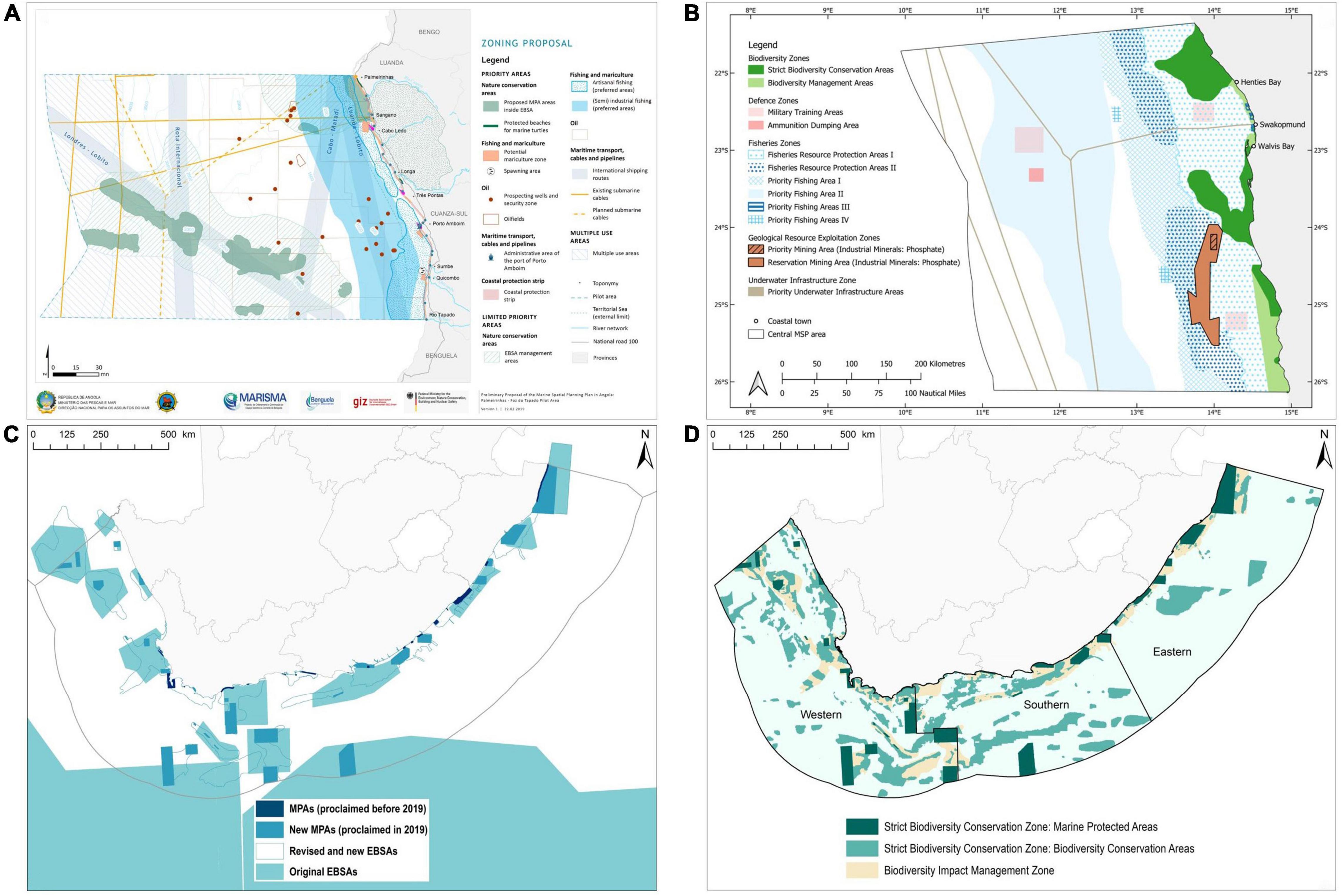
Figure 10. Examples of practical management actions in Ecologically or Biologically Significant Marine Areas (EBSAs) in the Benguela Current Region. (A) In Angola, EBSAs have been integrated into the draft zoning of the pilot Marine Spatial Plan, in part or wholly proposed as Marine Protected Areas (MPAs). (B) In Namibia, EBSAs have been integrated into the draft Central Marine Spatial Plan, which is currently out for stakeholder comments. (C) In South Africa, MPAs have been proclaimed in all but one of the original EBSAs, with all other new MPAs located within the new and revised EBSAs. Note that some MPAs comprise multiple polygons, and not all of these polygons overlap with the original EBSAs. (D) The revised EBSAs have been incorporated into South Africa’s National Coastal and Marine Spatial Biodiversity Plan, which is the basis for the biodiversity sector’s input into the National Marine Spatial Plan, and which will inform future MPA expansion.
In all three countries, the results of the EBSA processes have also become critical and prominent components of the biodiversity sector inputs into MSP. Furthermore, in Angola and Namibia, the delineations of the areas, the proposed zoning, and the respective management measures for each of the zones found strong integration in the drafts of the countries’ first marine plans and their regulations (Figures 10A,B). Overall, the zoning and management recommendations were adopted as suggested, with only minor changes to accommodate other sectors’ interests in particular locations of the sites. In Angola, the Longa Coastline EBSA and those portions of the Mussulo-Kwanza-Cabo Ledo Complex EBSA and of the Ombaca Canyon and Seamount Complex EBSA that fall within the planning area have become Biodiversity Conservation and Biodiversity Impact Management Zones, with related management restrictions (Figure 10A). In Namibia, the entire Namib Flyway EBSA and northern sections of the Namibian Islands EBSA were integrated as the Biodiversity Conservation Zone and Biodiversity Impact Management Zone, with detailed management measures as part of the draft central marine plan (Figure 10B). In South Africa, the SCP-led EBSA process was run alongside part of the National Biodiversity Assessment 2018 (Harris et al., 2019c; Sink et al., 2019d). The results culminated in the most recent NCMSBP (Harris et al., 2021), which included the EBSAs, and forms the basis for the biodiversity sector input into MSP that is currently being finalized through stakeholder engagement (Figures 10C,D). The South African EBSA process outputs, through the NCMSBP, are put forward as the biodiversity sector’s priorities, which it seeks to secure in the marine area plans as part of the coming MSP development processes.
Regionally, the processes between the neighboring BCLME countries to develop aligned cross-border spatial planning options that will inform national-level MSP processes, were initiated with a focus on the three EBSAs shared between countries. Aligned zoning and management recommendations have been developed and it is on this basis that Biodiversity Conservation and Biodiversity Impact Management Zones (Figure 8) with related management measures were agreed between the technical MSP and EBSA teams of the countries both in bilateral meetings and regionally at the level of the MSP and EBSA RWGs. These now form the basis of the continuing cross-border MSP exercises whereby the shared EBSAs represented the initial focal areas to commence the processes. The cross-border planning processes have since been expanded to cover larger planning areas that extend beyond the EBSA footprints and biodiversity zones. Once finalized, these cross-border outputs will inform future national MSP in those marine areas that straddle national borders. Another result of the regional process is the recommendation of the RWGs to the BCC structures to pursue the designation of the region’s first transboundary MPAs in the shared EBSAs. In the case of Angola, this will expand on the country’s current MPA designation process for the Angolan section of the transboundary Namibe EBSA.
Discussion
Tangible Progress Toward Increased Marine Spatial Management for Biodiversity in the Benguela Current Large Marine Ecosystem
In this paper, we demonstrated the process followed to develop a robust set of EBSAs that, in turn, are meaningfully informing implementation of MPA and MSP processes, with the aim of enhancing conservation and enabling more sustainable use of the ocean in the BCLME. Although implementation is still underway in the three countries, the approach does seem to be a successful one. Using SCP to refine EBSA boundaries and systematically address gaps resulted in much tighter delineations around the features for which the EBSAs are described. It also contributed to avoiding conflict with other sectors by refining the boundaries to only the required area, identifying the new EBSAs in places of lower conflict, where possible, and underpinning EBSA zoning into areas of strict and less strict management. Both refined boundaries and enhanced conflict avoidance are essential if EBSAs are to be part of a multi-sector marine management approach because it focuses biodiversity priorities in the essential places, and limits negotiations to only those areas of genuine conflict with other sectors. Importantly, at a national scale there are different but valid outcomes for biodiversity in the three countries, and at a regional scale, transboundary alignment was achieved in terms of approach, spatial priorities and recommended management actions. This illustrates the flexibility of the process that can be adapted in different contexts and applied at different scales. Further, the successes and benefits that have been identified from the project range from tangible products to intangible outcomes at regional, national, institutional, and personal levels.
The first of the tangible products was the completed descriptions for the new and revised EBSAs, which have been peer reviewed, sent to the CBD Secretariat and SBSTTA (which makes the countries the first worldwide to have done so), and integrated into the respective draft national Marine Spatial Plans and other processes granting licenses, e.g., mineral prospecting licenses. The process also required development of data-driven and expert-validated EBSA status assessments and other evidence-informed baseline reports (Governode Angola, 2020; DFFE, 2021; MFMR, 2021) that have provided a robust foundation on which the biodiversity sector’s inputs into MSP, and the Marine Spatial Plans themselves are being developed. There has been development of new legislation (e.g., South Africa’s new MSP Act, Republic of South Africa, 2018), formal institutionalization of MSP (e.g., Angola), and preparation toward and declaration of new MPAs (Angola and South Africa, respectively). Although the declaration of 20 MPAs in South Africa in 2019 (Republic of South Africa, 2019; Sink et al., 2019c) was during but outside of the MARISMA Project, all the new MPAs are within EBSAs, given that both encompass key biodiversity priority features and areas. The case in South Africa that followed from the initial set of EBSAs provides a prequel of the likely expansion of MPAs throughout the BCLME following the EBSA refinement process, and demonstrates the usefulness of EBSAs in supporting MPA processes, as was intended by the CBD COP. The project has also contributed to advancing the academic literature on marine spatial management through published papers (Kirkman et al., 2019; Finke et al., 2020a,b) and a book chapter (Harris et al., 2019b). Further, the relevance and usefulness of the content generated through the project is confirmed by the high website traffic on the EBSA Portal and MARISMA Project pages on the BCC website, and the number of views of the short “MSP in a nutshell” video on YouTube (>6,000 views of the English version at the time of writing3).
In addition to the tangible products, there are many intangible outcomes that, together with the former, have played a key role in making progress in the MSP processes and in strengthening enhanced biodiversity management in the BCLME. The MARISMA Project provided the supporting framework for inter-ministerial communication, networking, collaboration and understanding. There was important learning from other countries and ministries, particularly regarding the different users of the marine space and their requirements and needs. MARISMA participants also reported benefits of increased learning in the fields of integrated ocean governance, conflict management, and marine biodiversity, and how this has built capacity for better engagement with and across sectors in marine matters, and for active participation in international fora, such as the CBD COPs. Further, the learning, capacity building and project progress has fostered a self-reported sense of pride in participating in the project, which is also important for enhancing ownership of outcomes for sustainability, and job satisfaction.
Making Ecologically or Biologically Significant Areas Useful for Marine Spatial Planning
There were several steps that we needed to take to incorporate EBSAs into the MSP process. As indicated above, it was first necessary to refine the boundaries of the existing EBSAs for two reasons: first, to ensure that the full extent of the features for which the EBSAs were described were encompassed in the delineation; and second, to avoid unnecessary conflict with other sectors. It is worth noting, therefore, that very large EBSAs with boundaries that are not linked to finer scale biodiversity features (often Type 4 EBSAs, sensu Johnson et al., 2018) are less helpful in a MSP context. Therefore, even if the Benguela Upwelling System EBSA had not extended into the high seas, for example, we still would have had to exclude that EBSA from the analysis because it was delineated and described at a scale that is far broader than is required for detailed MSP. Its inclusion would have required the whole Namibian and South African west coast shelf to be proposed as biodiversity zones in a marine spatial plan, which would not have been feasible given that there are numerous productive fisheries, mining operations, and transport activities, including major ports, in the same area. Further, this EBSA includes some areas subsequently identified as being of low biodiversity value and/or in poor ecological condition. These very large areas can still be recognized as EBSAs but have limited value for spatial prioritization given the old adage: if everything is important, then nothing is important. In such cases, any specific sites, features or clusters thereof [mostly Type 1–3 EBSAs, sensu Johnson et al. (2018)] within the very large EBSAs must also be described so that they can be included in the marine spatial plan. This can be part of a gap analysis of the EBSAs within a country or region. Strictly speaking, the additional or revised EBSAs do not necessarily need to be endorsed by the CBD COP for them to be included in MSP processes. However, the additional weight of the site being internationally recognized as an EBSA, including being signed by the country’s own environment ministry as part of the proposal to the CBD Secretariat, could prove beneficial in MSP negotiations in favor of biodiversity.
To determine the required zoning and management recommendations for each EBSA, we needed to do a status assessment to determine the pressures on biodiversity, ecological condition, ecosystem threat status and ecosystem protection level within each one. It was also necessary to do a feasibility assessment of how realistic the proposed management recommendations were by considering the impact it would have on each of the sectors if their activities were restricted or no longer permitted in a particular place. In keeping with the objectives of the CBD (United Nations, 1992), the zoning and management objectives of the EBSAs need to support the conservation and sustainable use of marine biodiversity, as is respectively reflected in our proposed Biodiversity Conservation Zone and Biodiversity Impact Management Zone.
Lessons for Other Countries and Regions When Designing and Implementing Projects to Improve Marine Spatial Management for Biodiversity
In addition to draft protection targets, the Post-2020 Global Biodiversity Framework includes draft targets to: “ensure that all land and sea areas globally are under integrated biodiversity-inclusive spatial planning addressing land- and sea-use change, retaining existing intact and wilderness areas”, and to “ensure that at least 20 per cent of degraded freshwater, marine and terrestrial ecosystems are under restoration, ensuring connectivity among them and focusing on priority ecosystems” (CBD, 2021). In the marine environment, the approach taken to refine EBSAs using SCP, and integrate these into MSP can contribute to achieving these targets. Therefore, for other countries and regions intending to take on similar projects that advance implementing real-world, ecosystem-based marine spatial management, we have distilled seven key lessons from our work, outlined below (summarized in Box 1), that may be helpful in project design and processes. Many of these lessons (and the challenges identified in section “Lessons for Other Countries and Regions When Designing and Implementing Projects to Improve Marine Spatial Management for Biodiversity” below) are echoed in a global survey on implementing MSP (UNEP and GEF-STAP, 2014), and countries may find it useful to draw from both sources when designing real-world projects for implementation [see also CBD (2014)].
Box 1. Summary of lessons from the MARISMA Project and possible challenges to prepare for to guide design and implementation of similar national and regional marine spatial management projects.
Lessons from the MARISMA Project
1. Implementing MSP at a national and/or regional scale takes take time and resources; generally, much more time (and thus, resources) than is initially anticipated. Plan accordingly.
2. Structure the team and institutional setup carefully. We suggest having a neutral facilitator, technical team, and regional/national working groups that have a straight line of communication to government senior management.
3. The structure and design of the project and processes are important, and the marine spatial plan must be ecosystem based. We recommend having biodiversity (EBSA or similar; ideally SCP-based) and MSP workstreams running concurrently for fluent incorporation of the biodiversity zoning and management recommendations into the MSP process.
4. Stakeholder engagement is key to success, and can be very powerful when combined with iterative improvements in products that incorporate stakeholder feedback and input.
5. Learning-by-doing is a beneficial approach; international study tours, and intra-regional knowledge exchange within the regional working groups can support this.
6. Make provision for multiple languages in engagements and products (where relevant) and focus deliberately on improving ocean literacy among stakeholders and role players.
7. Plan for project longevity and follow-through after the project ends.
Be prepared for challenges if the following are weak, limited, or absent:
1. Government commitment and political will
2. Leadership, available capacities in governments to support and drive the process, and strong change agents and champions
3. Regional structures
4. Similar progress rates by all countries in regional projects
5. Data and legislation.
Our first lesson (1) is that it is important to recognize that projects of this nature take time and resources; generally, much more time (and thus, resources) than is initially anticipated. There needs to be long-term planning, including how the work will be taken forward once the project is gone. In terms of project design, (2) the structure of the team and institutional setup are important. It is very useful to have a neutral facilitator to provide leadership and overall project support; a technical team to provide analytical support; regional working groups (if applicable); and national working groups, ideally comprising all the relevant ministries and role players from the outset, and (biodiversity) champions and committed government officials taking the lead. It is also important to establish a straight line of communication from the working groups to the top hierarchy of government senior management. This is because of the risks of having technical and political separation in the process such that senior government decision-makers don’t take ownership of the products. Therefore, iterative improvements and direct engagements with senior managements that incorporate their feedback are essential. (3) The structure and design of the project and processes are important. It has proven very useful to have the EBSA and MSP workstreams running concurrently. It facilitates a fluent incorporation of the biodiversity zoning and management recommendations into the MSP process if the same underlying logic, spatial planning and management thinking (particularly in relation to the zoning and regulatory approach), and structure align, are co-developed, and jointly endorsed and applied. It is also critical for biodiversity to form the foundation of Marine Spatial Plans so that they can be truly ecosystem based (McLeod et al., 2005), which is why most MSP studies in the past two decades have been led by ecologists (Chalastani et al., 2021). Society needs healthy oceans for delivery of services and sustainable use (Worm et al., 2006). To ensure the MSP process is ecosystem based, the 12 Malawi Principles for the Ecosystem Approach (UNEP-CBD, 1998) can be useful to apply [see also McLeod et al. (2005)]. Further, as has been demonstrated previously (Harris et al., 2019b; Kirkman et al., 2019) and in this paper, SCP is a very powerful tool for refining EBSA (and other biodiversity priority area) inputs and creating a design that has a higher likelihood of implementation because it avoids conflict as far as possible. It is hence an approach that we recommend as a highly useful method, as illustrated in this real-world example from the BCLME.
In terms of the project process, (4) stakeholder engagement is key to success, and can be very powerful when combined with iterative improvements in products that incorporate their feedback and input. However, the amount of iterative revision needs to be carefully managed. It can make working with the products challenging for stakeholders (e.g., consultants trying to do Environmental Impact Assessments with spatial data that are continually changing), and fatigue can also set in if there are too many iterations. It also helps if the composition of the various working groups and stakeholder groups remain relatively constant throughout the project for continuity of engagements. Indigenous knowledge from stakeholders in local communities is also very useful to include and is encouraged by the CBD COP (CBD, 2008; CBD-SBSTTA, 2016). However, it is difficult to collect such fine-scale data at national and regional scales (Pennino et al., 2021). It is possible that these kinds of engagements are better suited to the MSP process itself once the broader biodiversity priorities have been identified at national and regional scales, which can then be interrogated at local scales for fine-scale boundary refinement and proposed management, and then fed back into the national and regional plans. Certainly, further research on how best to include indigenous knowledge and avoid top-down design in projects of this nature is strongly needed and encouraged.
It was very clear from the feedback by project participants just how significant the amount of learning was over the past few years. (5) Learning-by-doing has proven to be a beneficial approach, especially in this context where all countries in the region began their MSP processes concurrently, and without any prior MSP processes or structures in place. International study tours, and intra-regional knowledge exchange within the regional working groups can support this, as was demonstrated in the MARISMA Project. There was substantial investment in producing materials in a variety of formats that were readily available throughout the process, such that the outcome was a legitimate learning experience by co-leading local and government experts rather than simply outsourcing to a technical team. Consequently, (6) it is important to make provision for multiple languages in engagements and products (both within country and among countries in the region) and to focus deliberately on improving ocean literacy among stakeholders and role players. One example from MARISMA is the short “MSP in a nutshell video” on YouTube that is available in five main languages from the region. As mentioned previously, many people reported how much they learnt from the project, including about marine biodiversity, the value and need for healthy oceans, and about the different users of the ocean and their requirements. This kind of learning helps for constructive engagements and supports conflict resolution, partly because it also enhances the appreciation and respect for other perspectives and priorities (Finke et al., 2020b). Essentially, therefore, the process itself is an ocean literacy process, and (where necessary) making engagements, products and learning materials available in a diversity of languages as far as possible helps to be more inclusive.
Lastly, (7) it is imperative to plan for project longevity. One of the main concerns raised by project participants is that the great progress made to date will collapse once the MARISMA Project is finished. These concerns were primarily over capacity to continue the work, and the necessary structures to implement the respective Marine Spatial Plans. To address the former, there must be a focus on continuity and training, especially if the analyses are led by an external technical team. In-house capacity has been built during the MARISMA Project, but this needs to be strengthened through training courses and workshops so that countries can take the technical work forward on their own. In terms of developing the structures for implementation, this does not need to require a lot of funds and additional staff. With some innovation in institutionalizing the process, there are ways for existing staff to take on new responsibilities for MSP without having to hire new officials, as is being discussed in Namibia.
Be Prepared for Challenges
It is inevitable that real-world projects tackling multi-sector processes, such as MSP, will face a variety of challenges at various stages (see Box 1 for a summary). Most importantly, government commitment and political will are critical for project success. If it is absent or fluctuating, it can be very difficult to make progress. Because these projects tend to take several years, changes in leadership and consequently, potential changes in national priorities can also contribute to the variability in commitment and support. A lack of leadership and available capacities in governments to support and drive the process, as well as a limited number of strong change agents and champions can also be barriers to progress. This emphasizes why ocean literacy and the structure of the teams are so important so that all opportunities to influence and get input and support from senior government officials can be maximized. The same is true for addressing regional challenges, such as weak regional structures. Another challenge for collective regional success is that it depends on all countries progressing at reasonably similar rates. However, if the Regional Working Groups are well structured, with clear links to the National Working Groups, and if the timing of national and regional meetings is well coordinated, this can help to overcome some of these regional risks.
A lack of data and legislation can be challenging too. However, the former is not insurmountable. There are many options for compiling representative datasets, at least to represent biodiversity patterns and processes, even in data-poor regions (e.g., Harris et al., 2013, 2019b; Kirkman et al., 2019). Data to represent some of the sectors can be difficult to map, especially when it includes activities such as artisanal fishing, where the number of fishers and areas fished is not well known and there is limited scope to apply participatory processes. In these cases, the principle is always to use the best-available information, and to iteratively refine datasets over time. For the most part, though, there are some global datasets that can be used to represent sectors where such information does not exist within-country, e.g., Global Fishing Watch4 and Marine Traffic5. The absence of MSP-specific legislation can make the process much more complex, especially if there are multiple pieces of legislation that then need to be applied to piece the MSP together. On the other hand, it can also provide liberty to enable a relatively open, gradual, and experimental MSP process to take place and, eventually, the opportunity for new legislation to be drafted (Finke et al., 2020b).
Looking Ahead
The main aspiration of the MARISMA Project is implementing ecosystem-based MSP in each of the countries and across borders in support of sustainable development in the BCLME, while also providing additional protection in MPAs and/or via other place-based mechanisms, such as Other Effective Area-Based Conservation Measures (OECMs) for the key biodiversity features in EBSAs. It is encouraging to note, therefore, that the project and its outputs have resulted in additional funding from other sources for future projects, e.g., MPA support in Namibia. It is intended that there will be continued inter-ministerial and regional engagement, and political will and commitment to see the process through to full implementation, and for it to become a standard operating procedure by the authorities. Given the benefit that the ocean literacy aspects contributed to improving the understanding of marine biodiversity and the need to safeguard it, this might be one avenue by which the current momentum can be fueled. Continuing to provide materials that enhance ocean literacy and that make clear links between biodiversity and blue economy aspirations could help to foster and sustain political will and support, especially if it shows that more equitable benefits can be achieved in the process to drive the social agendas of the countries toward just and equitable growth.
Research and monitoring are also essential to iteratively advancing the process. This can contribute to generating more refined maps of biodiversity features, including ecosystem types, as well as better including adaptation to global change by identifying some climate-smart biodiversity priority areas (Queirós et al., 2021). Incorporation of local indigenous knowledge can also be helpful in refining priorities, and for including human dimensions and culturally significant areas in MSP (CBD-SBSTTA, 2016; Gee et al., 2017; Pennino et al., 2021). On this note, it is worthwhile mentioning that two MeerWissen projects (CoastWise and NAMares) have come out of the MARISMA Project, which will contribute to advancing the work through research, e.g., mapping ecosystem services and culturally significant areas (Gee et al., 2017) to improve integration of social-cultural aspects into MSP, and strengthening land-sea integration in the spatial prioritization. Additional benefits of monitoring and evaluation can further include demonstrating the good governance benefits of the process itself, which could further help persuade officials and strengthen their support.
Conclusion
Globally, most MSP initiatives have been undertaken in Europe, and more than half of the plans use qualitative methods (Chalastani et al., 2021). In our study, we provide a robust, data-driven, evidence-based example of ecosystem-based MSP development from three developing countries in Africa, which has also been included in the International Guide on Marine/Maritime Spatial Planning (UNESCO-IOC/European Commission, 2021). We used quantitative methods to refine and develop the spatial biodiversity priorities (EBSAs), assess the status of the biodiversity features for which the EBSAs were described, compiled management recommendations and tested their feasibility of implementation. As such, these outputs have informed the first steps of MSP in each of the three BCLME countries, and aided in guiding priorities for MPA expansion. Although the final steps of implementation are yet to be rolled out, the nationally driven processes, supported by the MARISMA Project, have already seen some excellent successes. We believe that the seven lessons that we have distilled from our work to date can be beneficial to others wishing to implement practical marine spatial management within EBSAs (or other biodiversity priority areas), toward securing important biodiversity and ecological processes that underpin the myriad of benefits that we derive from the world’s oceans, for current and future generations.
Data Availability Statement
The datasets presented in this study can be found in online repositories. They are available on the project’s EBSA Portal (http://cmr.mandela.ac.za/EBSA-Portal) and the BCC’s Geodata Portal (http://geodata.benguelacc.org/).
Author Contributions
LH, SH, and GF: conceptualization and visualization and writing—original draft. LH, SH, MA, AK, and RS: data curation and software. LH and SH: formal analysis. GF and ElM: funding acquisition. SH, GF, MA, RB, NC, SK, AK, ElM, ErM, KN, VR, and RS: project administration. LH, SH, GF, MA, RB, NC, KG, SK, AK, ElM, ErM, and RS: supervision. All authors contributed to investigation, methodology, validation, and writing—reviewing and editing of the manuscript, and approved the submitted version.
Funding
The MARISMA Project is funded by the German Federal Ministry for the Environment, Nature Conservation, Nuclear Safety and Consumer Protection (BMUV) through its International Climate Initiative (ICI) and further made possible through significant in-kind contributions by the Benguela Current Convention (BCC) and its contracting parties. It is implemented by GIZ (Deutsche Gesellschaft für Internationale Zusammenarbeit GmbH; German Development Cooperation) in partnership with the BCC and the Republics of Angola, Namibia, and South Africa.
Conflict of Interest
GF, MA, RB, ElM, and RS are employed by the Deutsche Gesellschaft für Internationale Zusammenarbeit (GIZ) GmbH who implemented the grant by BMUV. LH, SH, KG, and VR were contracted to the MARISMA Project by GIZ, but these financial relationships had no influence on what was written in the manuscript. LH and SH are employed by Nelson Mandela University. KG is employed by s.Pro | Sustainable Projects. VR is employed by Holísticos.
The remaining authors declare that the research was conducted in the absence of any commercial or financial relationships that could be construed as a potential conflict of interest.
Publisher’s Note
All claims expressed in this article are solely those of the authors and do not necessarily represent those of their affiliated organizations, or those of the publisher, the editors and the reviewers. Any product that may be evaluated in this article, or claim that may be made by its manufacturer, is not guaranteed or endorsed by the publisher.
Acknowledgments
We would like to thank many national, regional, and international workshop participants, including members of the national and regional working groups and task teams, the numerous scientists who shared data, and other stakeholders that have contributed to the SCP, EBSA, MSP, and MPA processes in the three countries as part of the MARISMA Project and beyond. We would also like to thank colleagues from the Global Ocean Biodiversity Initiative (GOBI) for their peer review support for validation of the process, whose inputs were very helpful.
Footnotes
- ^ http://cmr.mandela.ac.za/EBSA-Portal
- ^ https://www.benguelacc.org/index.php/en/marisma
- ^ https://youtu.be/HZu4QSRis7U
- ^ https://globalfishingwatch.org/
- ^ https://www.marinetraffic.com/
References
Ball, I., Possingham, H., and Watts, M. (2009). “Marxan and relatives: software for spatial conservation prioritization,” in Spatial Conservation Prioritization, eds A. Moilanen, K. Wilson, and H. Possingham (Oxford: Oxford University Press).
Bland, L. M., Keith, D. A., Miller, R. M., Murray, N. J., and Rodríguez, J. P. (eds) (2017). Guidelines For The Application Of IUCN Red List of Ecosystems Categories and Criteria. Version 1.1. Gland: IUCN. doi: 10.2305/IUCN.CH.2016.RLE.3.en
Boyer, D., Cole, J., and Bartholomae, C. (2000). Southwestern Africa: northern Benguela Current region. Mar. Pollut. Bull. 41, 123–140.
CBD (2008).“UNEP/CBD/COP/DEC/IX/20: Decision adopted by the Conference of the Parties to the Convention on Biological Diversity at its ninth meeting: IX/20. Marine and coastal biodiversity,” in Proceedings of the Conference of the Parties to the Convention on Biological Diversity, Ninth meeting, Bonn, 19–30 May 2008. Agenda item 4.9. Available online at: https://www.cbd.int/decision/cop/?id=11663 (accessed October 26, 2021).
CBD (2010a).“UNEP/CBD/COP/DEC/X/2: Decision adopted by the Conference of the Parties to the Convention on Biological Diversity at its tenth meeting. X/2. The Strategic Plan for Biodiversity 2011–2020 and the Aichi Biodiversity Targets,” in Proceedings of the Conference for the Parties, Tenth meeting, Nagoya, Japan, 18–29 October 2010. Agenda item 4.4.. Available online at: https://www.cbd.int/decision/cop/?id=12268 (accessed November 25, 2021).
CBD (2010b).“UNEP/CBD/COP/DEC/X/29: Decision adopted by the Conference of the Parties to the Convention on Biological Diversity at its tenth meeting: X/29. Marine and coastal biodiversity,” in Proceedings of the Conference of the Parties to the Convention on Biological Diversity, Tenth meeting, Nagoya, Japan, 18-29 October 2010. Agenda item 5.2. Available online at: https://www.cbd.int/decision/cop/?id=12295 (accessed July 21, 2021).
CBD (2014). Report of the Expert Workshop to Provide Consolidated Practical Guidance and a Toolkit for Marine Spatial Planning. UNEP/CBD/MCB/EM/2014/4/2. UNEP-CBD. Montreal, Canada.
CBD (2021). First Draft of the Post-2020 Global Biodiversity Framework. Third meeting of the Open Ended Working Group on the Post-2020 Global Biodiversity Framework. 23 August – 3 September 2021. CBD/WG2020/3/3. Available online at: https://www.cbd.int/article/draft-1-global-biodiversity-framework (accessed January 10, 2022).
CBD-SBSTTA (2016). Identifying Specific Elements for Integrating the Traditional, Scientific, Technical and Technological Knowledge of Indigenous and Local Communities, and Social and Cultural Criteria and Other Aspects for the Application of Scientific Criteria for Identification of Ecologically or Biologically Significant Areas (EBSAs) As Well As the Establishment and Management of Marine Protected Areas. Sixteenth meeting, Montreal, 30 April-5 May 2012. UNEP/CBD/SBSTTA/16/INF/10. Available online at: https://www.cbd.int/doc/meetings/sbstta/sbstta-16/information/sbstta-16-inf-10-en.pdf (accessed August 16, 2021).
Chalastani, V. I., Tsoukala, V. K., Coccossis, H., and Duarte, C. M. (2021). A bibliometric assessment of progress in marine spatial planning. Mar. Policy 127:104329. doi: 10.1016/j.marpol.2020.104329
de Barros Neto, V., de Fátima Jardim, M., de Vasconcelos, J. M. B., da Silva, Tomás, A., Naruseb, A., et al. (2016). Two decades of inter-governmental collaboration: three developing countries on the move towards ecosystem-based governance in the Benguela Current Large Marine Ecosystem. Environ. Dev. 17, 353–356. doi: 10.1016/j.envdev.2015.11.007
DEA (2016). National Protected Areas Expansion Strategy for South Africa 2016. Pretoria: Department of Environmental Affairs.
DFFE (2021). National Data and Information Report for Marine Spatial Planning: Knowledge Baseline for Marine Spatial Planning in South Africa. Cape Town: Department of Forestry, Fisheries and the Environment.
ESRI (2015). World Countries. Yarmouth, MA: Esri, DeLorme Publishing Company, Inc., Spatial Dataset.
Findlay, K. (2018). Operation Phakisa and unlocking South Africa’s ocean economy. J. Indian Ocean Region 14, 248–254. doi: 10.1080/19480881.2018.1475857
Finke, G., Gee, K., Gxaba, T., Sorgenfrei, R., Russo, V., Pinto, D., et al. (2020a). Marine spatial planning in the Benguela Current Large Marine Ecosystem. Environ. Dev. 36:100569. doi: 10.1016/j.envdev.2020.100569
Finke, G., Gee, K., Kreiner, A., Amunyela, M., and Braby, R. (2020b). Namibia’s way to marine spatial planning – using existing practices or instigating its own approach? Mar. Policy 121:104107. doi: 10.1016/j.marpol.2020.104107
Flanders Marine Institute (2018). Maritime Boundaries Geodatabase, Version 10. Available online at http://www.marineregions.org/ (accessed June 26, 2018).
Gee, K., Kannen, A., Adlam, R., Brooks, C., Chapman, M., Cormier, R., et al. (2017). Identifying culturally significant areas for marine spatial planning. Ocean Coast. Manag. 136, 139–147. doi: 10.1016/j.ocecoaman.2016.11.026
Governode Angola (2020). Relatório Preliminar sobre o Ordenamento do Espaço Marinho em Angola. Área Experimental Palmeirinhas – Foz do Tapado. Luanda: Governo de Angola.
Halpern, B. S., Frazier, M., Potapenko, J., Casey, K. S., Koenig, K., Longo, C., et al. (2015). Spatial and temporal changes in cumulative human impacts on the world’s ocean. Nat. Commun. 6:7615. doi: 10.1038/ncomms8615
Halpern, B. S., Selkoe, K. A., Micheli, F., and Kappel, C. V. (2007). Evaluating and ranking the vulnerability of global marine ecosystems to anthropogenic threats. Conserv. Biol. 21, 1301–1315. doi: 10.1111/j.1523-1739.2007.00752.x
Hamukuaya, H., Attwood, C., and Willemse, N. (2016). Transition to ecosystem-based governance of the Benguela Current Large Marine Ecosystem. Environ. Dev. 17, 310–321. doi: 10.1016/j.envdev.2015.06.013
Harris, L. R., Holness, S. D., Kirkman, S. P., Sink, K. J., Majiedt, P., and Driver, A. (2021). National Coastal and Marine Spatial Biodiversity Plan. Available online at: http://cmr.mandela.ac.za/NCMSBP (accessed June 1, 2021).
Harris, L. R., Bessinger, M., Dayaram, A., Holness, S., Kirkman, S., Livingstone, T.-C., et al. (2019a). Advancing land-sea integration for ecologically meaningful coastal conservation and management. Biol. Conserv. 237, 81–89. doi: 10.1016/j.biocon.2019.06.020
Harris, L. R., Holness, S., Finke, G., Kirkman, S., and Sink, K. (2019b). “Systematic conservation planning as a tool to advance Ecologically or Biologically Significant Area and marine spatial planning processes,” in Maritime Spatial Planning, eds J. Zaucha and K. Gee (Cham: Palgrave Macmillian). doi: 10.1007/978-3-319-98696-8_4
Harris, L. R., Sink, K. J., Skowno, A. L., and Van Niekerk, L. (eds) (2019c). South African National Biodiversity Assessment 2018 Technical Report Volume 5: Coast. Pretoria: South African National Biodiversity Institute.
Harris, L., Holness, S., Nel, R., Lombard, A. T., and Schoeman, D. (2013). Intertidal habitat composition and regional-scale shoreline morphology along the Benguela coast. J. Coast. Conserv. 17, 143–154. doi: 10.1007/s11852-012-0226-z
Heileman, S., and O’Toole, M. J. (2009). “I West and Central Africa: I-1 Benguela Current LME,” in The UNEP Large Marine Ecosystems Report: A Perspective On Changing Conditions In LMEs Of The World’s Regional Seas, eds K. Sherman and G. Hempel (Nairobi: United Nations Environment Programme).
Holness, S., Kirkman, S., Samaai, T., Wolf, T., Sink, K., Majiedt, P., et al. (2014). Spatial Biodiversity Assessment and Spatial Management, including Marine Protected Areas. Final report for the Benguela Current Commission project BEH 09-01. Namibia: Benguela Current Commission.
Johnson, D. E., Barrio Froján, C., Turner, P. J., Weaver, P., Gunn, V., Dunn, D. C., et al. (2018). Reviewing the EBSA process: improving on success. Mar. Policy 88, 75–85. doi: 10.1016/j.marpol.2017.11.014
Jouffray, J.-B., Blasiak, R., Norström, A. V., Österblom, H., and Nyström, M. (2020). The blue acceleration: the trajectory of human expansion into the ocean. One Earth 2, 43–54. doi: 10.1016/j.oneear.2019.12.016
Keith, D. A., Rodríguez, J. P., Rodríguez-Clark, K. M., Nicholson, E., Aapala, K., Alonso, A., et al. (2013). Scientific foundations for an IUCN Red List of Ecosystems. PLoS One 8:e62111. doi: 10.1371/journal.pone.0062111
Kirkman, S. P., and Nsingi, K. K. (2019). “Marine biodiversity of Angola: biogeography and conservation,” in Biodiversity of Angola: Science & Conservation: A Modern Synthesis, eds B. J. Huntley, V. Russo, F. Lages, and N. Ferrand (Cham: Springer International Publishing), 43–52. doi: 10.1007/978-3-030-03083-4_3
Kirkman, S. P., Holness, S., Harris, L. R., Sink, K. J., Lombard, A. T., Kainge, P., et al. (2019). Using systematic conservation planning to support marine spatial planning and achieve marine protection targets in the transboundary Benguela Ecosystem. Ocean Coast. Manag. 168, 117–129. doi: 10.1016/j.ocecoaman.2018.10.038
Kirkman, S. P., Mann, B. Q., Sink, K. J., Adams, R., Livingstone, T. C., Mann-Lang, J. B., et al. (2021). Evaluating the evidence for ecological effectiveness of South Africa’s marine protected areas. Afr. J. Mar. Sci. 43, 389–412. doi: 10.2989/1814232x.2021.1962975
Kirkman, S. P., Yemane, D., Oosthuizen, W. H., Meÿer, M. A., Kotze, P. G. H., Skrypzeck, H., et al. (2013). Spatio-temporal shifts of the dynamic Cape fur seal population in southern Africa, based on aerial censuses (1972–2009). Mar. Mammal Sci. 29, 497–524. doi: 10.1111/j.1748-7692.2012.00584.x
Lenihan, H. S., Gallagher, J. P., Peters, J. R., Stier, A. C., Hofmeister, J. K. K., and Reed, D. C. (2021). Evidence that spillover from marine protected areas benefits the spiny lobster (Panulirus interruptus) fishery in southern California. Sci. Rep. 11:2663. doi: 10.1038/s41598-021-82371-5
Majiedt, P., Holness, S., Sink, K. J., Reed, J., Franken, M., Van der Bank, M. G., et al. (2019). “Chapter 4: Pressures on marine biodiversity,” in South African National Biodiversity Assessment 2018 Technical Report Volume 4: Marine Realm, eds K. J. Sink, M. G. Van der Bank, P. A. Majiedt, L. R. Harris, L. J. Atkinson, S. P. Kirkman, et al. (Pretoria: South African National Biodiversity Institute),Available online at: http://hdl.handle.net/20.500.12143/6372
Majiedt, P., Holness, S., Sink, K., Oosthuizen, A., and Chadwick, P. (2013). Systematic Marine Biodiversity Plan for the West Coast of South Africa. Cape Town: South African National Biodiversity Institute.
Makhado, A. B., Braby, R., Dyer, B. M., Kemper, J., McInnes, A. M., Tom, D., et al. (2021). “Seabirds of the Benguela Ecosystem: Utilisation, Long-Term Changes and Challenges,” in Birds - Challenges and Opportunities for Business, Conservation and Research, ed. H. J. Mikkola (London: IntechOpen).
Margules, C. R., and Pressey, R. L. (2000). Systematic conservation planning. Nature 405, 243–253. doi: 10.1038/35012251
McLeod, K. L., Lubchenco, J., Palumbi, S. R., and Rosenberg, A. A. (2005). Scientific Consensus Statement on Marine Ecosystem-Based Management. Signed by 221 academic scientists and policy experts with relevant expertise and published by the Communication Partnership for Science and the Sea. Available online at: http://compassonline.org/?q=EBM (accessed April 25, 2011).
MFMR (2021). Current Status Report: Knowledge Baseline for Marine Spatial Planning in Namibia, 2nd Edn. Windhoek: Ministry of Fisheries and Marine Resources.
Moilanen, A., Wilson, K., and Possingham, H. (eds) (2009). Spatial Conservation Prioritization. Oxford: Oxford University Press.
Naidoo, A., Hamukuaya, H., Hara, M., Mngxe, Y., and Raakjær, J. (2021). Polycentric regional ocean governance opportunity in the Benguela Current Convention. Front. Mar. Sci. 8:703451. doi: 10.3389/fmars.2021.703451
Nerem, R. S., Beckley, B. D., Fasullo, J. T., Hamlington, B. D., Masters, D., and Mitchum, G. T. (2018). Climate-change–driven accelerated sea-level rise detected in the altimeter era. Proc. Natl. Acad. Sci. 115, 2022–2025. doi: 10.1073/pnas.1717312115
New Era (2019). Namibia Ups Tempo On Marine Protection Amid Phosphate Talks. New Era 2019-09-24. Available online at: https://neweralive.na/posts/namibia-ups-tempo-on-marine-protection-amid-phosphate-talks (accessed November 29, 2021).
Pennino, M. G., Brodie, S., Frainer, A., Lopes, P. F. M., Lopez, J., Ortega-Cisneros, K., et al. (2021). The missing layers: integrating sociocultural values into marine spatial planning. Front. Mar. Sci. 8:703451. doi: 10.3389/fmars.2021.633198
Queirós, A. M., Talbot, E., Beaumont, N. J., Somerfield, P. J., Kay, S., Pascoe, C., et al. (2021). Bright spots as climate-smart marine spatial planning tools for conservation and blue growth. Glob. Change Biol. 27, 5514–5531. doi: 10.1111/gcb.15827
Republic of South Africa (2018). Act No. 16 of 2018: Marine Spatial Planning Act. Government Gazette Vol. 647: No. 42444, 06 May 2019. Republic of South Africa: Government Gazette.
Republic of South Africa (2019). National Environmental Management: Protected Areas Act, 2003 (Act No. 57 of 2003). Notices 757-776. Government Gazette No. 42478, Vol. 647, Republic of South Africa: Government Gazette, 1–84.
Roberts, C. M., Hawkins, J. P., and Gell, F. R. (2005). The role of marine reserves in achieving sustainable fisheries. Philos. Trans. R. Soc. B Biol. Sci. 360, 123–132. doi: 10.1098/rstb.2004.1578
Samaai, T., Sink, K., Kirkman, S., Atkinson, L., Florence, W., Kerwath, S., et al. (2020). “The marine animal forests of South Africa: importance for bioregionalization and marine spatial planning,” in Perspectives on the Marine Animal Forests of the World, eds S. Rossi and L. Bramanti (Cham: Springer International Publishing), 17–61. doi: 10.1007/978-3-030-57054-5_2
Secretariat of the Convention on Biological Diversity (2021). Special Places in the Ocean: A Decade of Describing Ecologically or Biologically Significant Marine Areas. Montreal, QC: Secretariat of the Convention on Biological Diversity.
Sink, K. J. (2016). Deep Secrets: The Outer Shelf And Slope Ecosystems Of South Africa. Cruise Report: ALG 230 – ACEP_DSC.
Sink, K. J., Attwood, C. G., Lombard, A. T., Grantham, H., Leslie, R., Samaai, T., et al. (2011). Spatial Planning To Identify Focus Areas For Offshore Biodiversity Protection In South Africa. Final Report for the Offshore Marine Protected Area Project. Cape Town: South African National Biodiversity Institute.
Sink, K. J., Harris, L. R., Skowno, A. L., Livingstone, T.-C., Franken, M., Porter, S., et al. (2019a). “Chapter 3: Marine ecosystem classification and mapping,” in South African National Biodiversity Assessment 2018 Technical Report Volume 4: Marine Realm, eds K. J. Sink, M. G. Van der Bank, P. A. Majiedt, L. R. Harris, L. Atkinson, S. Kirkman, and N. Karenyi (Pretoria: South African National Biodiversity Institute).
Sink, K. J., Holness, S., Skowno, A. L., Franken, M., Majiedt, P. A., Atkinson, L. J., et al. (2019b). “Chapter 7: Ecosystem Threat Status,” in South African National Biodiversity Assessment 2018 Technical Report Volume 4: Marine Realm, eds K. J. Sink, M. G. Van der Bank, P. A. Majiedt, L. R. Harris, L. Atkinson, S. Kirkman, and N. Karenyi (Pretoria: South African National Biodiversity Institute).
Sink, K. J., Sibanda, S. M., Fielding, P., Skowno, A. L., Franken, M., Harris, L. R., et al. (2019c). “Chapter 8: Ecosystem Protection Level,” in In South African National Biodiversity Assessment 2018 Technical Report Volume 4: Marine Realm, eds K. J. Sink, M. G. Van der Bank, P. A. Majiedt, L. R. Harris, L. Atkinson, S. Kirkman, and N. Karenyi (Pretoria: South African National Biodiversity Institute).
Sink, K. J., Van der Bank, M. G., Majiedt, P. A., Harris, L. R., Atkinson, L., Kirkman, S., et al. (eds) (2019d). South African National Biodiversity Assessment 2018 Technical Report Volume 4: Marine Realm. Pretoria: South African National Biodiversity Institute.
Sink, K., Holness, S., Harris, L., Majiedt, P., Atkinson, L., Robinson, T., et al. (2012). National Biodiversity Assessment 2011: Technical Report. Volume 4: Marine and Coastal Component. Pretoria: South African National Biodiversity Institute.
Stevenson, I. R., and Bamford, M. K. (2003). Submersible-based observations of in-situ fossil tree trunks in Late Cretaceous seafloor outcrops. Orange Basin, western offshore, South Africa. S. Afr. J. Geol. 106, 315–326. doi: 10.2113/106.4.315
Teck, S. J., Halpern, B. S., Kappel, C. V., Micheli, F., Selkoe, K. A., Crain, C. M., et al. (2010). Using expert judgment to estimate marine ecosystem vulnerability in the California Current. Ecol. Appl. 20, 1402–1416. doi: 10.1890/09-1173.1
UNEP and GEF-STAP (2014). Marine Spatial Planning in Practice – Transitioning from Planning to Implementation. An Analysis Of Global Marine Spatial Planning experiences, eds H. L. Thomas, S. Olsen, and O. Vestergaard (Nairobi: UNEP).
UNEP-CBD (1998). “Report of the Workshop on the Ecosystem Approach. UNEP/CBD/COP/4/Inf.9,” in Proceedings of the Conference of the Parties to the Convention on Biological Diversity. Fourth meeting. 4-15 May 1998, Bratislava, Slovakia.
UNEP-CBD (2009). Azores Scientific Criteria And Guidance For Identifying Ecologically Or Biologically Significant Marine Areas And Designing Representative Networks Of Marine Protected Areas In Open Ocean Waters And Deep Sea Habitats. Montreal, QC: Secretariat of the Convention on Biological Diversity.
UNESCO-IOC/European Commission (2021). MSPglobal International Guide on Marine/Maritime Spatial Planning. UNESCO. (IOC Manuals and Guides no 89). Paris: UNESCO-IOC/European Commission.
United Nations (1992). “Convention on Biological Diversity,” in Proceedings of the United Nations Conference on Environment and Development (UNCED)/Rio Earth Summit, 5 June 1992, Rio de Janeiro, Brazil.
Urban, M. C. (2015). Accelerating extinction risk from climate change. Science 348, 571–573. doi: 10.1126/science.aaa4984
Weir, C. R. (2019). “The Cetaceans (Whales and Dolphins) of Angola,” in Biodiversity of Angola. Science and Conservation: A Modern Synthesis, eds B. J. Huntley, V. Russo, F. Lages, and N. Ferrand (New York, NY: Springer Nature), 445–470. doi: 10.1007/978-3-030-03083-4_16
Keywords: Ecologically or Biologically Significant Marine Areas (EBSAs), systematic conservation planning (SCP), marine spatial planning (MSP), marine protected areas (MPAs), ecosystem-based management (EBM), spatial prioritization, Benguela Current Large Marine Ecosystem, Marxan
Citation: Harris LR, Holness SD, Finke G, Amunyela M, Braby R, Coelho N, Gee K, Kirkman SP, Kreiner A, Mausolf E, Majiedt P, Maletzky E, Nsingi KK, Russo V, Sink KJ and Sorgenfrei R (2022) Practical Marine Spatial Management of Ecologically or Biologically Significant Marine Areas: Emerging Lessons From Evidence-Based Planning and Implementation in a Developing-World Context. Front. Mar. Sci. 9:831678. doi: 10.3389/fmars.2022.831678
Received: 08 December 2021; Accepted: 02 February 2022;
Published: 03 March 2022.
Edited by:
Joseph Appiott, Secretariat of the Convention on Biological Diversity, CanadaReviewed by:
Daniela Diz, Heriot-Watt University, United KingdomNicholas J. Bax, Commonwealth Scientific and Industrial Research Organization (CSIRO), Australia
Copyright © 2022 Harris, Holness, Finke, Amunyela, Braby, Coelho, Gee, Kirkman, Kreiner, Mausolf, Majiedt, Maletzky, Nsingi, Russo, Sink and Sorgenfrei. This is an open-access article distributed under the terms of the Creative Commons Attribution License (CC BY). The use, distribution or reproduction in other forums is permitted, provided the original author(s) and the copyright owner(s) are credited and that the original publication in this journal is cited, in accordance with accepted academic practice. No use, distribution or reproduction is permitted which does not comply with these terms.
*Correspondence: Linda R. Harris, aGFycmlzLmxpbmRhLnJAZ21haWwuY29t