Abstract
In the last decades, climate change and the rapid urbanization due to the development of the coastal economy have led to biodiversity loss and the fragmentation of habitat in many coastal zones. The presence of protected areas cannot prevent the progress of land degradation. However, these areas are very important because they provide significant ecosystem services and affect local tourism. With regard to increasing adaptation strategies to human pressures and climate change, the present study proposes a detailed monitoring activity and an ecological restoration plan which could improve the resilience of a protected coastal zone in the Pantano forest of Policoro, located on the Ionian coast (southern Italy). In this area, continuous phenomena of intensive deforestation, hydraulic reclamation actions, and fires have reduced the native species of particular naturalistic value, favouring the advancement of desertification, coastal erosion, and saltwater intrusion. The proposed actions are derived from a preliminary analysis on maps, UAV-images, climate data and from meetings with the local community. The operative process detailed in this article could be applied to other protected areas which are subjected to the same phenomena and problems.
Introduction
Protected coastal areas (PCAs) provide a multitude of ecosystem functions and services able to improve the delicate ecological balance and human well-being (Rousseau and Deschacht, 2020; Samuelsson et al., 2020). They are essential for reducing the effects of climate change through the protection of coasts from erosion and of the hinterlands from storm surges, flood events, and extreme winds (Yáñez-Arancibia and Day, 2004; Spalding et al., 2014; Epanchin-Niell et al., 2017; Littles et al., 2018; Ferro-Azcona et al., 2019). Thanks to the presence of a rich biodiversity, these areas reduce greenhouse gas emissions by sequestering and storing large amounts of carbon, help to improve water quality, and regulate water availability through filtration, groundwater renewal and maintenance of natural flows (Spalding et al., 2014; Epanchin-Niell et al., 2017; You et al., 2018).
At the same time, PCAs are places of interest for tourism and for recreational and leisure activities, thus contributing to the socio-economic growth of entire territories (You et al., 2018; Zhai et al., 2020).
In many cases PCAs host lowland forests that act as windbreaks (You et al., 2018), preventing sand and marine aerosol from reaching agricultural land and plantations, and thus enabling their use.
In the past few decades, PCAs have been subjected to serious threats deriving mainly from climate change which, together with an increase in intensity and a reduction in the duration of rainfalls, higher temperatures, and the rise of sea level, favours a rapid alien species invasion (Epanchin-Niell et al., 2017) and coastal habitats fragmentation and loss (Yu et al., 2017; You et al., 2018).
Other stressors are related to human activities represented by urban expansion, agricultural production, industrialization, mining, tidal flat farming, development of tourist infrastructures, logging, and land reclamation, which have caused phenomena of marine pollution, soil degradation, loss of biological diversity, and reduced resilience of coastal communities (Kim et al., 2017; Yu et al., 2017; Adhikari and Hansen, 2018; Xie et al., 2018; You et al., 2018; Zhai et al., 2020).
Hence the importance of implementing actions to safeguard and redevelop PCAs in order to ensure the continuous supply of ecosystem services, prevent biodiversity loss, and achieve sustainable and integrated management of landscapes and natural resources, according to the goals outlined by the Agenda 2030, the Treaty 2002/413/CE ICZM (Integrated Coastal Zone Management), the Directive 2008/56/CE (Marine Strategy Framework Directive, MSFD), the Commission Decision 2010/477/UE, and the Directive 2014/89/UE (Maiolo et al., 2020).
In the ongoing discussion on the need for a post-2020 Global Biodiversity Framework, the time is ripe for showcasing the essential role of PCAs in maintaining biodiversity, and promoting global human health should be deemed essential. It is equally important to remember that the protection of natural capital, including ecosystem resilience and regeneration, biodiversity protection and adaptation to climate change, can also be an economic multiplier (Hepburn et al., 2019). Investments in nature-based solutions can foster long-term health and promote job creation (Hockings et al., 2020). In the last few years, the number of research papers on coastal restoration has considerably grown (Zhang et al., 2018), together with the many restoration projects implemented worldwide (Bayraktarov et al., 2016), many of which are centred on the return to a condition of the ecosystem as close as possible to the original one. However, these restoration activities might not be entirely feasible in the future due to various obstacles, such as climate change and anthropic activities (Hobbs and Norton, 1996). In addition, empirical research and experimental tests over recent decades have demonstrated that incorporating indirect positive interactions among transplants and between foundation species can increase ecosystem resilience (Zhang et al., 2018). Therefore, ecological engineering is focussing on restoring habitats in a sustainable manner, taking into account both man and the environment, especially in places where human pressure is greater (Mitsch, 2012). In particular, the coastal protection infrastructures are considerably growing and will continue to do this according to the increase of populations and related intensification of hazards (Scyphers et al., 2011; Hinkel et al., 2014). However, the downsides of common coastal armouring strategies (e.g., seawalls, revetments, groins) also need to be considered: habitat loss (Titus, 1998), lower floral and faunal biodiversity (Gittman et al., 2016), and depressed socio-economic resilience (Smith et al., 2020), especially due to their expensive maintenance cost. In this view, ecosystem-friendly alternatives to traditional coastal defence structures are emerging, such as natural and nature-based infrastructure (Sutton-Grier et al., 2018), nature-based solutions (Nesshöver et al., 2017), hybrid infrastructure (Sutton-Grier et al., 2015), ecosystem-based coastal defence (Temmerman et al., 2013), soft ecological engineering (Strain et al., 2019), and living shorelines.
The substitution of hard structures with environmentally-friendly interventions and nature-based infrastructures (NBS), after having properly analysed the bio-geomorphic feedbacks concerning the ecosystems, is thus fundamental in order to create a more sustainable coastal economy (Speybroeck et al., 2006; Warnken and Mosadeghi, 2018; Ružic et al., 2019). Even the high cost involved in the use of NBS and their potential failures need to be taken into account, together with the specific nature of the area to be restored (Maiolo et al., 2020).
In addition to the NBS there are various measures of environmental improvement such as a correct landscape conservation design, dune, beach and shore face nourishments, re-location and retreat from coasts or decision support tools (Powell et al., 2019). The correct landscape conservation design is addressed to the habitat migration and to the extension of protected areas. These actions allow coastal habitats to: respond dynamically to sea level rise; secure additional long-term protection of habitat for fish, plants, and wildlife (Morelli et al., 2016); reduce habitat loss and degradation; maintain the diversity of habitats; facilitate shifts in species’ range, distribution, phenology and adaptation in response to changing conditions by providing corridors for migration and dispersal (Bartuszevige et al., 2016); secure freshwater and sediment inflows.
Dune, beach and shore face nourishments have been termed an environmentally friendly alternative to hard coastal protection structures, such as groins, revetments or breakwaters (Schoonees et al., 2019; Staudt et al., 2021). Unlike hard structures, these “soft” or “green” measures are believed to adapt to rising sea levels or changing sea states, and do not lead to scour or erosion of down drift beaches (Dean, 2002; Bird and Lewis, 2015). Beach nourishments increase the beach volume and can be used to restore or create new habitats for coastal and marine flora and fauna, such as seabirds, sea turtles etc. (Jones and Mangun, 2001; Van Egmond et al., 2018).
Re-location and retreat from coasts (e.g., shoreline setbacks and rolling easements) help protect coastal ecosystems by reducing anthropogenic impacts such as from structures that inhibit dynamic responses of habitats (e.g., shoreline armouring) and from runoff that can increase water pollution. They also enable the natural migration of the shoreline up to a point by reducing impediments from the built environment, if based on long-term estimates of erosion or sea level rise, and reserve habitat for vulnerable species, such as by prohibiting new development or construction within a certain distance from the coast. Lastly, decision support tools that allow managers to integrate and continuously update predictions of risk from climate change, land use, and human population growth projections can increase the effectiveness of different natural infrastructures and support short- and long-term biological, cultural, social, and economic goals (e.g., Bartuszevige et al., 2016; Powell et al., 2019). Some management options (e.g., retreat from coasts and open space preservation) could focus on risk reduction by moving people and property out of harm’s way, often with economic incentives like flood insurance discounts. When combined with other zoning and land use protections, these actions could create the secondary and tertiary benefits of increasing the persistence and resilience of natural habitats and species. For example, managing lands after the re-location of people or infrastructure in the coastal zone could enable the natural migration of coastal systems as needed in response to the relative sea level rise.
It often happens that restoration actions are carried out on an area with minimal or no knowledge of the natural resources state or how plant and animal species react and adapt to climate changes and human activities, as well as of what kind of interventions can reduce land degradation and biodiversity loss (DeAngelis et al., 2020; Binley et al., 2021). Unfortunately, the lack of funding has progressively reduced the monitoring activities both before and after the implementation of preservation projects and plans, allowing for only small-size interventions in limited areas (maximum 350 acres), and so reducing their efficacy (DeAngelis et al., 2020; Smith et al., 2020).
In this context, the main goal of the present paper is to illustrate a proposal of a detailed monitoring activity and an ecological restoration plan in a protected area located on the Ionian coast (southern Italy) in order to allow the conservation and provision of ecosystem services and to improve the resilience of coastal habitats. The case study is Pantano forest of Policoro where continuous phenomena of intensive deforestation, hydraulic reclamation actions, and fires have reduced the native species of particular naturalistic value, favouring the advancement of desertification, coastal erosion, and saltwater intrusion.
The proposed actions are derived from a preliminary analysis on maps, UAV-images, climate data, and from meetings with the local community. In this direction, a process involving the population has been set in motion, aiming at choosing and sharing environmental recovering actions and interventions leading to a River Agreement (Antunesa et al, 2009; Voghera, 2020). This will allow strengthening people’s bond with nature and thus their commitment to the environment (Camargo et al., 2009; Aceves-Bueno et al., 2015; Jakobcic and Stokowski, 2019), since the local community would be more aware of the actions to be adopted for the sustainable management of their own territory. This way, conflicts between the different stakeholders would be reduced and the conservation programs could benefit long-term (Cooper et al., 2007; Aceves-Bueno et al., 2015).
The operative process detailed in this article could be applied to other protected areas which are subjected to the same phenomena and problems.
Material and methods
Case study
The Pantano forest of Policoro is located at 40°6’-40°18’N and 16°30’-16°48’E in southern Italy, in the province of Matera, between the municipalities of Policoro and Rotondella (Figure 1). It is a protected natural area of about 4 km2 and has an altitude between 0 and 5 m asl. It includes, according to Directive 92/43/CE “Habitat”, the Site of Community Importance (SCI) “Bosco Pantano di Policoro and Costa Ionica Foce Sinni” and is a Special Area of Conservation (SAC).
Figure 1
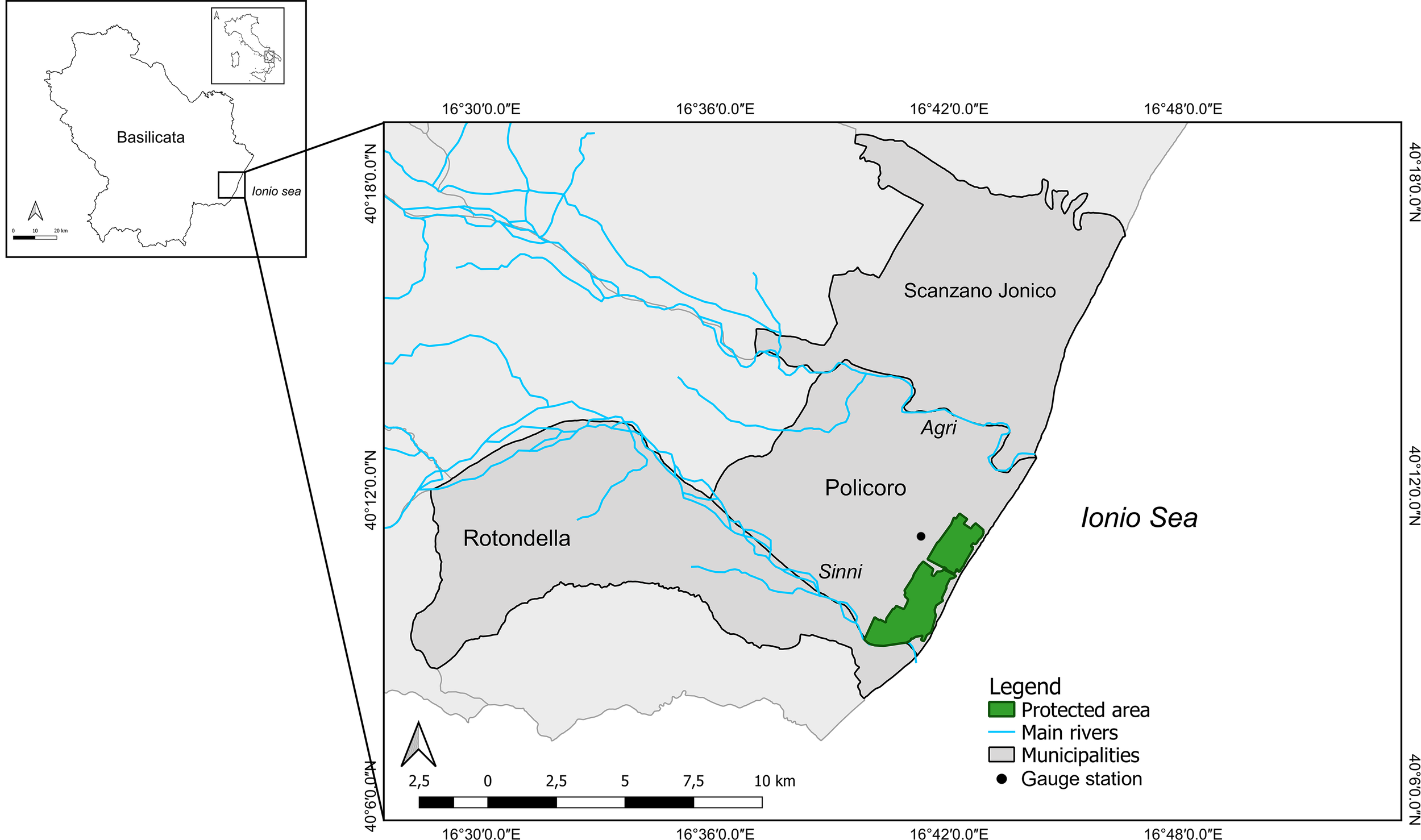
Study area location.
The Pantano forest of Policoro is located to the right of the river Sinni, near the mouth which, during the flood events, brings sand and clay to the area and contributes to its modelling with depressed areas and hills, influencing the diversification of the existing vegetation. It is characterised by an extensive flat surface with low and sandy beaches, sometimes pebbly. Until 1930, this area was covered by marshes that extended from the hilly inland areas to the sea and which have been reduced since the 1930s thanks to the construction of a drainage system (Figure 2). Currently, the water is carried into a dewatering pump and is partly used for irrigation purposes and partly discharged into the sea.
Figure 2
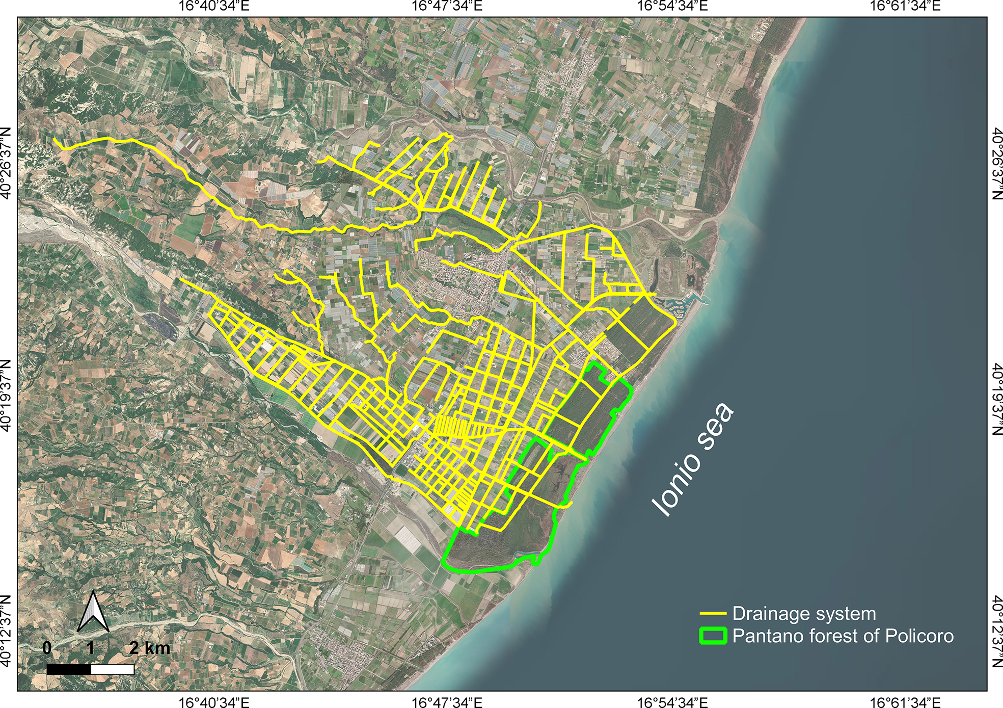
Drainage system drawn on satellite image of 2019 acquired via web-service GoogleMaps (publisher: Data SIO, NOAA, U.S. Navy, NGA, GEBCO; year of publication: 10 August 2019; created map title: Google Landsat/Copernicus; access date 7 March 2022).
The area has a high biodiversity and is rich in habitats. In detail, the inner vegetation is mainly represented by a hygrophilous forest, while near the coastline it is characterised by psammophilous communities typically suitable to sandy environments.
The plant species of the hygrophilous forest are the field elm, the English oak, the black alder, the poplars, and the laurel. In addition, the area shows 27 species of fauna of community interest according to the Habitat Directives (42/93/EEC) and the “Birds” Directive (79/409/EEC) and in particular 21 species of birds, 2 of mammals, 2 of reptiles and 2 of invertebrates. The site is also an important rest area for migrating species such as the Osprey. In the riparian environments of the river Sinni and in the open channels there are the Spinarello, the Eel and the Otter, a species at risk of extinction and a priority of Annex II of the Habitat Directive. While the coastline and the shallow water host a large number of Carretta turtles and Cetaceans, in its deepest marine waters live the common dolphin, numerous pods of Stenellas and the Sperm Whale, the largest living carnivore.
Analysis of the area-specific phenomena
The intensive deforestation and hydraulic reclamation actions, already begun in the early 90s and aimed at the recovery of areas for agricultural use, have led to the gradual disappearance of forest cenosis and native species of particular naturalistic value, which have been replaced by shrubby Mediterranean scrub and meso-hygrophilous formations. In particular, these actions have reduced the forest area by about 8 km2. Furthermore, repeated fires over the years have caused excessive density and decay of the topsoil, scarcity of ecological corridors and excessive fragmentation of forests (Bovio et al., 2002). The Monte Cotugno dam, the largest reservoir in Europe in rammed earth (built between May 1972 and March 1983) and the extraction activities of gravel and sand from the bed have limited the supply of water and sediments of the river Sinni over time, thus altering the delicate eco-systemic balance of the area and favouring the advancement of the desertification, saltwater intrusion and coastal erosion. This latter, in addition to the reduction of river solid discharge, is caused by changes of wind pattern, wave climate and increase of wave energy. In this area, the directions of the wave motion characterised by the greatest energy are between 130° N and 150° N. Besides, the widespread presence of permanent and seasonal structures, built on the longshore sand dune close to the foreshore, amplified the wave action increasing the local erosion rates with an appreciable reduction in beach width. Studies of literature on shoreline changes for the Ionic coast of Basilicata region underlined how at the Sinni mouth there has been a retreat of the emerged beach of over 500 m in the last fifty years (Spilotro et al., 2006), with a beach loss ranging from 2 mm to 20 mm per year (Greco et al., 2005).
Figure 3 reports the evolution of land use from 1990 to 2018 in the area surrounding the Pantano forest. As evidenced by the maps, where only the land use typology over 0.5% is depicted, this area is covered by complex cultivation patterns, which have increased by about 14% since 1990. The remaining area is mainly constituted of fruit trees and berry plantations and non-irrigated arable land. Discontinuous urban fabric has given way to continuous one. A slight growth of industrial or commercial units (from 0.2% to 0.7%) and the birth of port areas are observed. Near the coasts, the transformation of a little part of broad-leaved and coniferous forests into mixed forests, the reduction of sand dunes and the disappearance of lagoons are visible. In detail, the last Corine Biotopes habitat map (2013), reported in Figure 4, underlines the presence of fruit and citrus orchards (37% and 16% respectively), extensive cultivation (11.5%), and Mediterranean Subnitrophilous grass communities (7.9%).
Figure 3
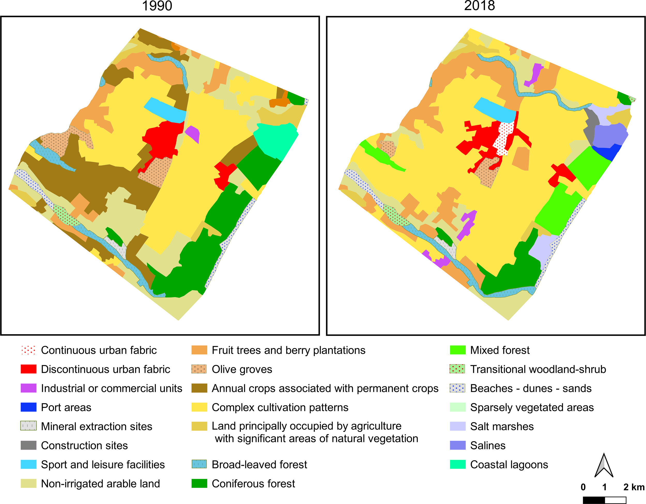
Land use in 1990 and 2018 in the Pantano forest area.
Figure 4
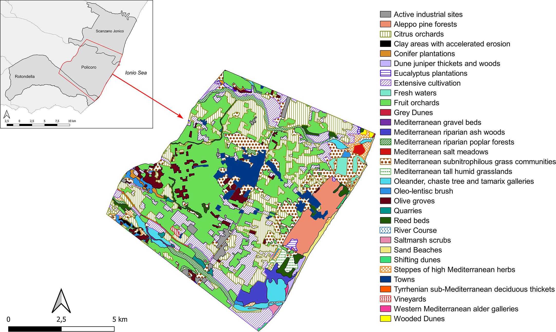
Corine Biotopes habitat map of Pantano forest surrounding in 2013.
A monitoring activity, carried out with UAV imaging between the end of 2020 and the beginning of 2021, was useful to evaluate some phenomena. For example, it showed the spread of desertification in the hinterland with the presence of non-vegetated areas (Figure 5A) and an absence of the retro-dune plants (Figure 5B). In addition, literature studies highlighted a retreat of the coastline equal to 30/40 cm per year, representing a threat to tourist structures and infrastructures (Greco et al., 2004; Greco et al., 2005) and puts the inland areas at risks of storm surges, strong sirocco winds and marine aerosol problems, especially in winter. This thinning of the beach (Figure 6A) has changed the vegetation in the area over time (Figure 6B). In fact, Figure 7 shows a scarce and uneven presence of Elymeto and Ammophila Arenaria, which do not favour the colonisation of other species or the growth of the dune. As a result, the pioneer maquis in direct contact with the beach is subject to the negative effects of the marine spray and winds (Figure 8).
Figure 5
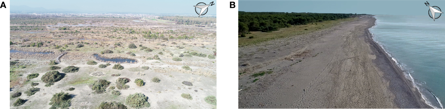
(A) Signs of desertification phenomenon in areas near the coast. (B) Disappearance of the back-barrier plants.
Figure 6
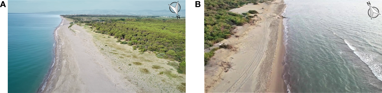
Change of the vegetation due to the thinning of (A) north west and (B) southwestern area of the beach.
Figure 7
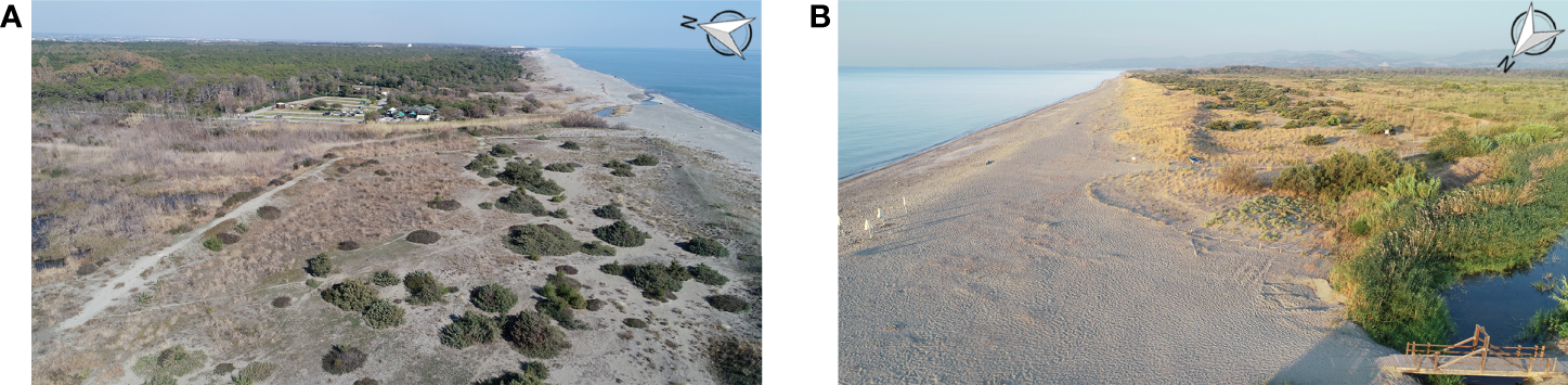
Scarce and uneven presence of (A) Elymeto and (B) Ammophila Arenaria.
Figure 8
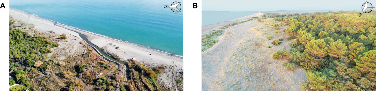
Negative effects of the marine spray and winds in the (A) north west and (B) southwestern area of the beach.
Furthermore, the rise in temperatures has favoured the settlement of invasive alien species, seriously threatening the biodiversity and ecological integrity of the biotope. The invasive alien species are mainly artificial plantations consisting of pines, carried out in the past to protect the agricultural inland, and a rapid and progressive colonisation of woody plant weeds, such as Pinus spp., Eucaliptus spp., Robinia pseudoacaia, Acacia spp. and Agave. From an ecological point of view, the massive presence of these invasive species caused a serious impoverishment of biodiversity, trivializing the phytocoenoses and altering the trophic chains linked to the ecotones. For example, acacias have a greater degree of invasiveness and tend to spread to the detriment of native species. The Aleppo pine represents a concrete threat to the habitats, such as the habitat of priority interest 2250 “Coastal dunes with Juniperus”, with the presence of two junipers: Juniperus oxycedrus ssp. Macrocarpa and Juniperus phoenicea. Reforestation with Aleppo pine and eucalyptus, in addition to reducing the quality and heterogeneity of environment and landscape, constitutes a serious risk of fires.
The seasonal analysis of the maximum and minimum temperatures acquired by the gauge station located near to Forest Pantano (Figure 1) underlines a light increase in winter and autumn of Tmax and Tmin in the last five years (Figure 9). In particular, for the maximum temperature, an oscillating trend is observed around the average value determined in the period 2000-2021 equal to 21.38°C for winter and 33.26°C for autumn. Instead, there has been an increase in recent years of minimum temperatures in the winter months, which are approximately 20% higher than the average value (-3.55°C) in 2019 up to 50% by 2021, while in the autumn of the same years the value is almost four times the average value (1.58°C).
Figure 9
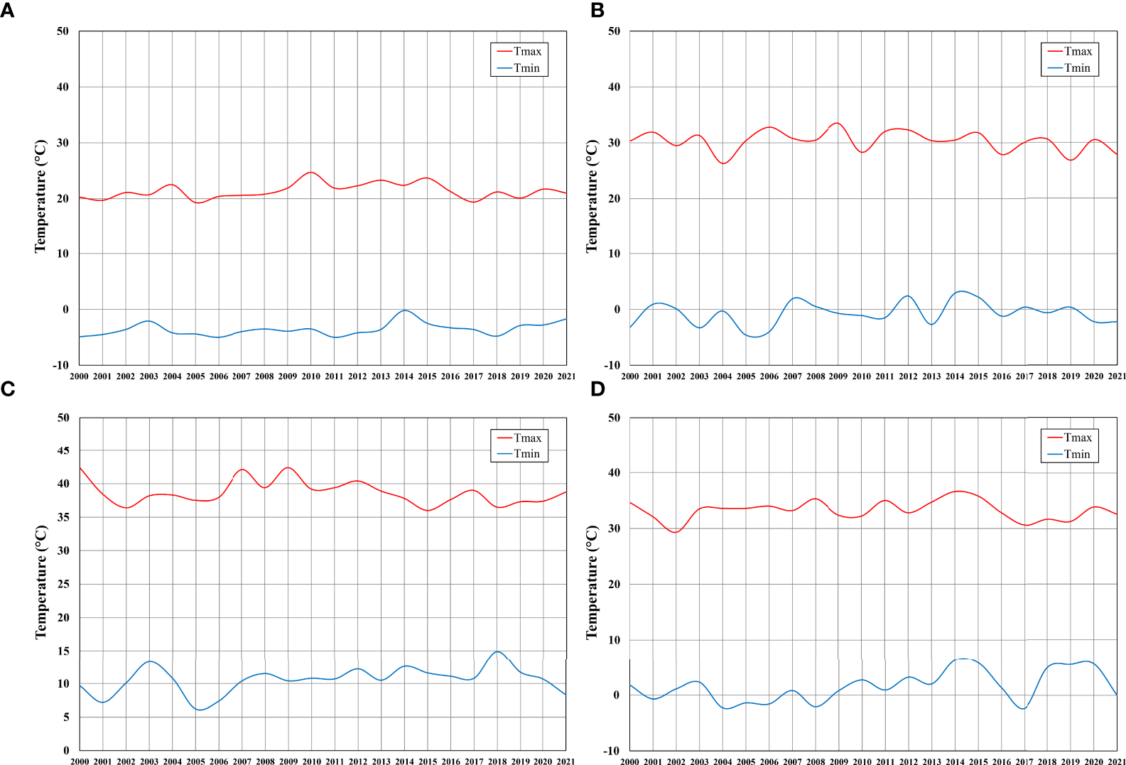
Maximum and minimum seasonal temperatures acquired by the gauge station in 2000-2021 period in (A) winter; (B) spring; (C) summer and (D) autumn.
In the same period, an unusual decrease of rainfall is noted in the winter months, which influences the water discharge in rivers for the rest of the year (Figure 10A). In fact, a reduction in 2019 of about 27% compared to the average value calculated over the period 2000-2021 is recorded, reaching the 64% in 2021.
Figure 10
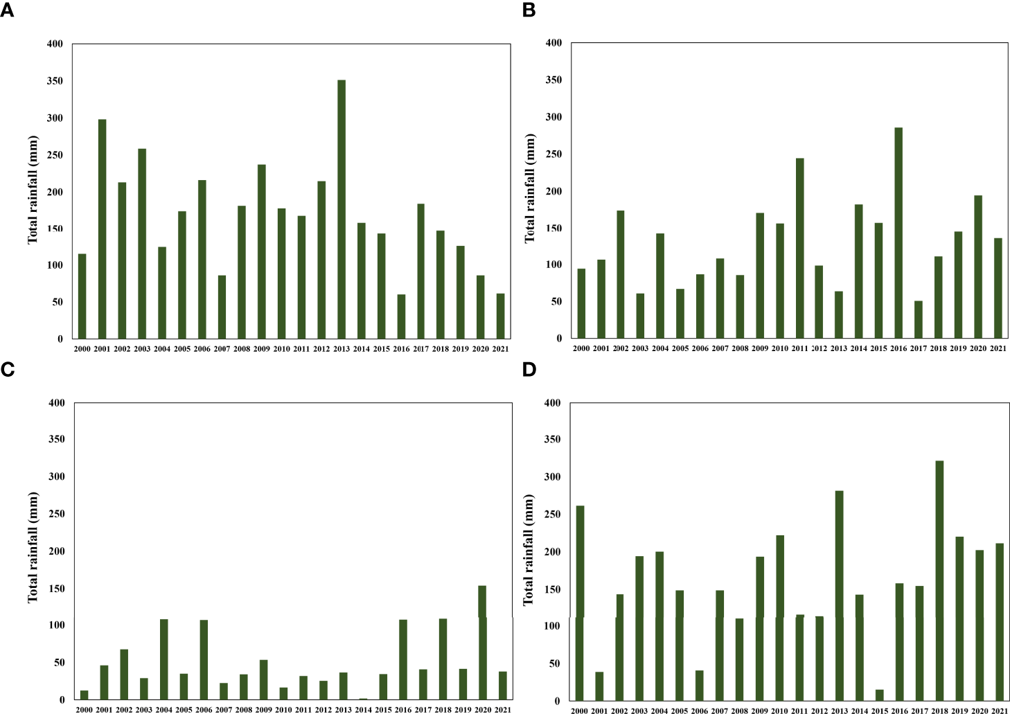
Total seasonal rainfall acquired by the gauge station in 2000-2021 period in (A) winter; (B) spring; (C) summer and (D) autumn.
An increase of total seasonal rainfall (usually storm events) compared to the average value is instead observed in the spring (30%), summer (33%) and autumn (10%) months of the last three years. These weather conditions, associated with tidal bore (propagation of marine waves from the mouth towards upstream), have created floods and soil impoverishment (Figure 10B–D).
Currently, the degradation process does not seem to stop despite the restoration and reforestation interventions that have taken place in the last decades. For example, some sporadic reforestation works on sandy dunes were carried out as early as the 2000s, in order to create an effective breakwater for the protection of agricultural and unproductive lands. In 2007, through a project funded by European Regional Development Fund 2007-2013, some nature-based solutions were used for the reconstruction of the dunes and the planting of native species along the coast. However, these interventions were concentrated only in the sandy dunes and retro-dunes, failing to completely prevent the coastal erosion and the presence of the saline wedge. In 2009, the Natura 2000 network project, from which the Site of Community Interest Management Plan was born, increased the knowledge of the area, even if still very limited with regard to some hydraulic, hydro-geological, geomorphological, ecological and landscaping aspects. All this emphasizes the importance of adopting a detailed monitoring plan useful to detect a series of interventions and actions on the area.
Proposed improvement of the coastal habitat resilience
The preliminary analysis described above showed the presence of worrying phenomena such as desertification, coastal erosion, and saltwater intrusion. As regards the presence of the seawater intrusion in the study area, the analysis of the concentration maps of Total Dissolved Solids (TDS), groundwater electrical conductivity, and of the ions present in seawater generally indicated that seawater contamination is relevant along a strip of land stretching for 2.5-3 km from the coastline inwards. The highest concentrations above 1000 mg/L have been recorded near the shoreline along rivers. One of the causes of this phenomenon is that in the altimetrically depressed areas during the periods of low pressure and absence of runoff, seawater through the high tides rises up the river beds and infiltrates the aquifers (Polemio et al., 2003).
Consequently, it is strongly advised to intervene before the progress of these phenomena completely compromises the habitats and biodiversity of the area. For this reason, a new planning of actions that would contribute to the upgrading of aspects related to the sustainable management of coastal ecosystems is required.
Various meetings in the area, involving various stakeholders, allowed addressing some actions and interventions in order to recover and enhance the environment and landscape, while favouring the socio-economic growth of the territory at the same time.
These meetings are part of a bottom-up participation process started in 2019 by the consortium FLAG Coast to Coast within the local development operational program EMFF (European Maritime and Fisheries Fund) 2014-2020 Basilicata, leading to the Sinni River Agreement.
River Agreement (RA) represents an innovative governance model that can help in the drafting of potential plans and practices for a sustainable management of fluvial territories (Antunesa et al, 2009; Voghera, 2020). It is an advanced form of negotiated planning that involves social actors in order to: improve people’s knowledge of existing territorial conditions and the effects of human activities; increase social awareness; include society in the identification and implementation of solutions; encourage innovative changes in setting objectives and urban and architectural design, starting with the legal and planning framework of an Action Plan. In other words, RA allows the development of a convergence and coordination between bottom-up and top-down strategies and practices, as well as an integration between multi-level and multi-scale actions carried out by the main actors in the territorial systems.
The Sinni River Agreement is aimed at giving value to the fluvial and coastal landscape and achieving the delicate balance between the exploitation of natural resources for socio-economic development and the conservation of ecosystem services needed for community well-being.
Currently, about 60 actors among public and private entities have joined forces: 16 municipal administrations of the concerned river basin; 1 regional tourism promotion company; 1 national park, 7 trade organisations; 26 associations; 4 companies; and 3 schools.
So far, a first document has been drawn up detecting 4 macro-sectors such as Environment, Identity, Landscape and Local Development, which correspond to medium-long term interventions for the achievement of the objectives of the European strategy: Safety and Prevention of Hydraulic Risk and Hydrogeological Disruption; Improvement of the river state ecology; Sustainable use of resources, Sustainable development, Territorial identity and landscape enhancement, Protection of ecosystems and biodiversity; Protection of groundwater and surface water resources (Figure 11).
Figure 11
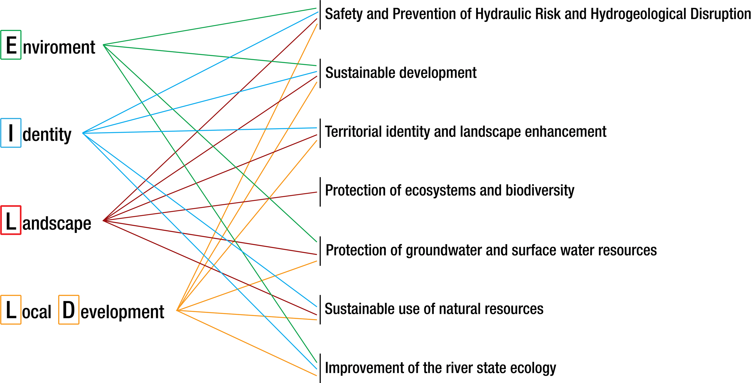
Link between the objectives of the River Agreement and those of the EU strategy.
Within each macro-sector, the actions indicated in Figure 12 are aimed at: improving the health of the rivers and surrounding areas; the rediscovery and enhancement of the historical and cultural heritage of the area; reconstituting the link between inland and coastal areas; the sustainable use of soil and natural resources; the diversification of production processes; reversing the trend of migration of young people; and generating wealth from the redevelopment of rural areas.
Figure 12
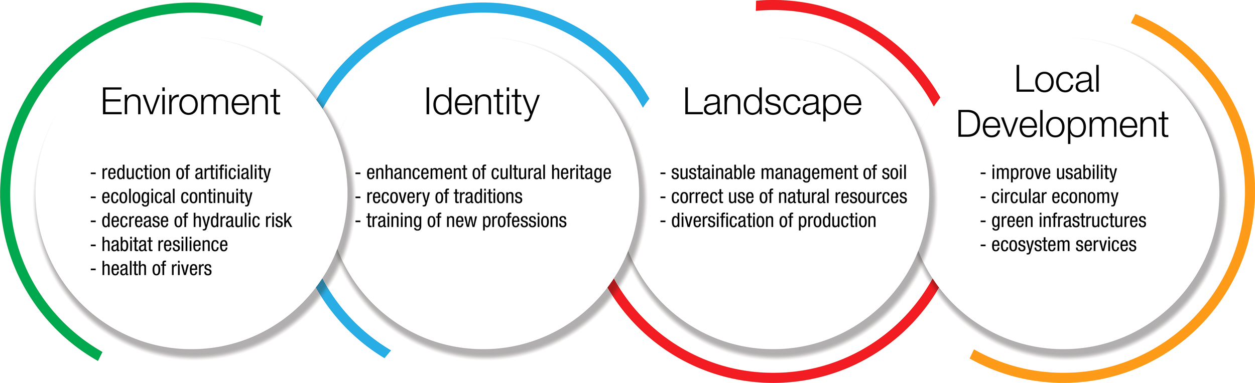
The 4 macro-sectors of the preliminary River Agreement.
The proposal described below belongs to the macro-sector Environment and considers an integrated monitoring activity on hydraulic, hydro-geological, geomorphological, ecological and landscaping aspects, in order to have detailed knowledge of the area and a first ecological restoration plan.
Monitoring activity plan
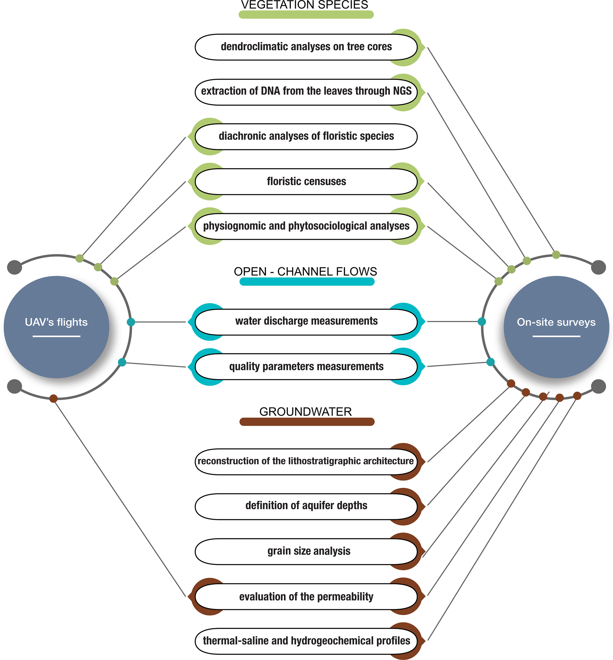
Figure 13 shows the flow-chart of the proposed monitoring activity.
Figure 13
The planned monitoring activities in Pantano forest of Policoro area.
With regard on-site surveys of vegetation, woody cores will be taken from a sample of tree species for dendroclimatic analyses, in order to study the growth trend over time and highlight the changes in the physiological state as well as the climatic and anthropic stresses determining the deterioration of the plant. DNA will be extracted from the leaves to investigate the genetic structure of the population and to identify, through next-generation sequencing (NGS) techniques, the processes of adaptation to the main environmental factors. These technologies greatly facilitate handling the genomic data and the understanding of the complex nature of epigenetic modifications at the genomic level, providing advantages such as parallel computation power, thereby minimising data analysis time (Arora and Tollefsbol, 2021). They are able to generate a vast amount of DNA sequence information from a broad array of lifeforms in an amazingly short time. NGS has also made possible the investigation of the genetic bases of diseases and gene mapping through large scale screening of genome variation (Ejigu and Jung, 2020). The comparison of the sequence data with a growing standard reference library of identified organisms will help in presenting the different taxa available environmental samples with high accuracy (Hajibabaei et al., 2011; Fadiji and Babalola, 2020). Recent findings in the computational techniques have aided the study of biodiversity across space and time through the use of annotation and DNA clustering employing phylogenetic and alignment techniques (Hajibabaei et al., 2011). Due to corresponding increases recorded in both breadth and number of data using NGS platforms, ecological researches are now been channelled towards the use of large volumes of sequence data. This approach has helped reducing error and bias results attributed to PCR and the run time is significantly shorter. Many platforms have been discovered lately, each with advantages and disadvantages. These identified platforms use distinct template in its preparation and different chemistries in its sequencing signal detection (Mardis, 2013; Van Dijk et al., 2014).
The monitoring of the floristic species will be carried out with a diachronic analysis through interpretation of orthophotos obtained from satellites and UAVs. These latter are capable of taking high-quality photos and videos that can provide better, cheaper, and more timely information in order to improve the management of PAs (Pimm et al., 2015; Ho et al., 2018). The accuracy of the data provided by UAV has now been confirmed by several studies (e.g., Addo et al., 2018). Harwin and Lucieer (2012) have verified this by comparing the results of the drone with Differential Global Positioning System (DGPS) and total station measurements for the coastal erosion monitoring in a sheltered estuary, while Vousdoukas et al. (2011) observed how the images of nearshore sand bars generated by the UAVs have a greater spatial coverage and a better observation point with regards to those acquired with satellite. Other studies, carried out on coasts monitoring, compared data from drone point cloud, terrestrial laser scanner (TLS) and Global Navigation Satellite System (GNSS) surveys and concluded that the results obtained by UAVs are very good (Mancini et al, 2013; Chikhradze et al., 2015; Hackney and Clayton, 2015). Drones also make it possible to monitor environmental changes that can lead to the loss of native plant species and, at the same time, the expansion of alien or introduced species. Drones are also used for forest fire monitoring as well as for the identification of undergrowth vegetation, the identification of dead wood and canopy mortality, which in coastal areas could be due to marine aerosol.
In particular, for this research the traditional photo interpretation of UAV data will allow a first subdivision of the territory into homogeneous areas based on the physiognomy and structure of the vegetation (agricultural areas, woods, shrubs, grasslands, etc.). Successively, the backward photo interpretation (Walz, 2008; Acosta and Ercole, 2015) will make it possible to obtain some information from the past through reverse order processing of recent images and to investigate how the different habitats have been influenced by changes in composition and landscape structure, which have occurred in the last 90 years. This technique has been successfully applied to the backward monitoring of coastal dune habitats in central Italy (Malavasi et al., 2013), investigating how these habitats have been influenced by changes in the composition and structure of the landscape occurred in the last 60 years. An advantage of this technique is that it is based on the interpretation of photos and numerical data detected by low-cost planes, satellites, drones or space probes and over very large areas.
The floristic census in the field will mainly focus on the identification of species of conservation interest, threatened species and species which may have a key role in representing the ecological needs of other species (umbrella species), in highlighting the functionality of an ecosystem (key species), in underlining an ecological problem (e.g., species sensitive to the fragmentation of the territory), in providing a framework of possible expansion (introduced species), and in drawing the attention of the public and facilitating conservation actions (flag species). This field research represents the main tool to deepen basic knowledge on the biological heritage of fragile and poorly investigated areas where endangered plants and habitats may co-occur. Moreover, the correct identification and the standardised description of rare vegetation units may play a key role in protecting locally endangered plant communities and preserving all the steps of local vegetation series. These actions improve the survival and the natural dynamics between and within the patches of natural and semi-natural habitats, rare at the national (Rosati et al., 2007; Rosati et al., 2008) or the regional scale (Viciani et al., 2016).
At the same time, a physiognomic analysis to recognize the different vegetation formations and phytosociological surveys will be performed which, statistically processed, will propose different clusters based on levels of qualitative-quantitative floristic similarity, to which the phytosociological types consistent with the syntaxonomic hierarchy will be referred. The analysis will be conducted by distinguishing plant associations that are dynamically connected from the neighbouring ones belonging to different series. This discrimination of the vegetation physiognomic characteristics will be relevant to tracking the changes in vegetation structure and composition, thus understanding the vegetation responses to changes in environmental conditions (Sharma et al., 2017). Different attempts have been made for the classification and mapping of vegetation by exploiting the remote sensing data obtained from satellites or aircrafts. More recently, vegetation mapping by using near surface multispectral, hyperspectral, or lidar imaging from manned or unmanned aircrafts is growing (Su et al., 2016; Sankey et al., 2017). Though some researchers have reported satisfactory results using multiple spectral mixture analysis (Roberts et al., 1997), digital image enhancements (Chikr El-Mezouar et al., 2011), temporal image fusion (Schmidt et al., 2015), and texture based classifications (Murray et al., 2010), the physiognomic analysis is probably the mostly used method for the vegetation classification. The use of data from satellite or UAV reduces greatly the costs of this analysis.
In order to analyse the impacts of climate change and anthropogenic activities on rivers and irrigation channels, water discharges and quality parameters measurements will be carried out both with UAV’s flights and with in situ sampling. In addition, for the same purpose, geognostic surveys are provided for the reconstruction of the lithostratigraphic structure and the definition of the aquifer depth, the soils monitoring for the determination of the granulometric and permeability characteristics and, finally, field and laboratory investigations for the tracing of thermal-saline and hydrogeochemical profiles. A numerical modelling will then be carried out to simulate the behaviour of groundwater and surface water, addressed to planning hydraulic-forestry interventions, in order to both reduce flooding phenomena during the rainy periods and irrigate some areas during dry periods. In detail, for surface water it will be possible to use the open source software HEC-RAS 6.1, able to model the flows for low and high values of water discharges. Being an extra-urban residential area, for high flows a water discharge with return period equal to ten years is advised (Leal et al., 2022; Parizi et al., 2022). To simulate numerically the behaviour of groundwater, the MODFLOW software, based on a generalised control-volume finite-difference (CVFD) approach, will be used (Hanckmann et al., 2022; Suponik et al., 2022). It is capable of modelling small and large aquifers for several years and with a high degree of accuracy.
An ecological restoration plan
Coastal sand dunes are among the most vulnerable and threatened ecosystems in the world (Prisco et al., 2020; Laporte-Fauret et al., 2021). Despite their dynamic structure and the high resilience of biotic communities, these ecosystems are fragile due to general fragmentation, limited extensions, and excessive anthropogenic pressure (Lazarus, 2017). Compared to terrestrial ecosystems, because of the environmental and microclimatic conditions, they have selected peculiar and specialised fauna and flora, often also exclusive (Gracia et al., 2019; Fabbri et al., 2021). Furthermore, these environments represent important ecological corridors for the animals in the coastal environment (Cooper and Jackson, 2020). This habitat exclusivity involves the coexistence of multiple elements of different biogeographical origins, united by high levels of specialisation.
In addition to having a high ecological and landscape value (Gracia et al., 2019; D’Alessandro et al., 2020), these environments also play an essential role in the defence of the coasts (Arulmoorthy and Srinivasan, 2017; Tordoni et al., 2018) by increasing their resilience. In particular, they are able to reduce the risk of coastal erosion since they constitute a sediment reserve capable of replenishing the beach (Gracia et al., 2019; Tordoni et al., 2020).
The dunes can oppose marine flooding and defend the hinterland vegetation from the saline aerosol of the wave motion. In addition, the native vegetation of these environments provides a significant refuge and source of food for a wide range of invertebrates, birds, mammals, reptiles, amphibians and other wildlife (Feagin et al., 2010; Drius et al., 2019). According to the 4th Monitoring Report (92/43/EEC Habitats Directive), the conservation status of Italian coastal sand dunes and inland dunes habitats is dramatically bad: the overall assessment reports 88% of habitats in a bad conservation status and the remaining 12% in an inadequate condition (Prisco et al., 2020). One of the greatest threats is related to their limited geographical extent which, with a continuously decreasing trend over the years, will lead to an increasingly worse future scenario. The most affected habitats are those with the minimum extension, which are mainly concentrated in the Mediterranean Region (shifting dunes, fixed dunes, dunes with Hippophae rhamnoides, dune grasslands, dunes with Juniperus species, maquis with Sclerophyllous shrubs, inland dunes).
Currently, coastal dunes of the Pantano forest are threatened by anthropic disturbances (tourism, urbanization), shoreline erosion, climate change, and biological invasion. Impacts due to the latter factor include the occupation and transformation of the habitat, the alteration of ecological relations and evolutionary processes, as well as the loss and fragmentation of biodiversity (Tordoni et al., 2018). Once alien species are set, they may outcompete the native fauna and flora, causing severe imbalances in the ecosystem, and seriously affecting economic activities (Gracia et al., 2019). For all these reasons, the restoration of the dunes environments is essential for the conservation of the forests and biological communities.
Consequently, in the first phase the actions will be aimed at gradually eliminating the invasive species on the dunes in order to favour the development of natural vegetation, and in particular of rare species.
To reduce coastal erosion and protect inland areas from wave motions and winds, windbreak barriers will be provided in semi-rigid natural and degradable material (wood and reeds) arranged in a “checkerboard” pattern, in order to accumulate sand and protect native and pioneer species.
Once the embryonic dunes have formed, it will be necessary to consolidate them through the replanting of native species selected during the census and analysis phase. For example, different studies have shown how Ammophila transplantation has had positive stabilisation effects by requiring low maintenance costs, a long useful life, and fast realisation. In particular, the Ammophila Arenaria has excellent dune building capabilities compared to other grass species (Konlechner and Hilton, 2009; Walker et al., 2013; van Puijenbroek et al., 2017). It creates high, hummocky peaked dunes, which can easily withstand flooding and erosion (Seabloom et al., 2013; Bruls et al., 2016). Even the practice of sprinkling the dunes with the beached remains of Posidonia and other beached sea herbs has given good results, as these are natural materials widely available on site and which rapidly decompose without leaving traces or requiring restoration work (De Falco et al., 2003; Ruiz and Romero, 2003; Corenblit et al., 2007; Balestri et al., 2012; Cooper and Jackson, 2020; Maiolo et al., 2020). Recent studies demonstrated that planting mangroves along the shore or beach can reduce the wave height by 50% to 99% (McIvor et al., 2012; Raju and Arockiasamy, 2022). The aim of this intervention is also to restore the integrity of the habitats and allow a reconstruction of the shrub vegetation profiles in the internal areas over time. It has been showed, in fact, that increasing habitat areas inland from the shoreline results in quadratic and exponential reductions in wave heights.
Subsequently, in order to avoid the trampling of the dunes by swimmers, which is the first cause of their deterioration, an elevated walkway and fences will be planned. These interventions, if carried out with natural materials such as wood, have a low environmental impact and a good useful life even if the maintenance costs are high.
The formation of mobile and fixed dunes will allow a renovation of the hinterland forest with the reforestation of typical species of the area such as English oak, poplar, oxyphilous ash and elm.
The restoration interventions will also include the re-naturalisation of the artificial channels both in the riverbed and on the banks. This phase will be preceded by in-depth maintenance and cleaning through the use of techniques and tools with low environmental impact.
As a last step, an existing backdunal pond will be recovered both to further facilitate the repopulation of fauna and flora and to create a reserve of freshwater in order to hinder the intrusion of the saline wedge. The lake will be fed by a system of small canals made with naturalistic engineering techniques and organised in such a way as to connect with the drainage canals and the natural hydrographic network.
Discussion and conclusions
The present paper reports an improvement action plan, which should be implemented at the Pantano forest of Policoro, a protected area located on the Ionian coast of southern Italy, in order to stop the biodiversity loss and fragmentation of habitat.
The study area has a high biodiversity and is rich in habitats. In fact, it shows 27 species of fauna of community interest according to the Habitat Directives (42/93/EEC) and the “Birds” Directive (79/409/EEC) and, in particular, 21 species of birds, 2 of mammals, 2 of reptiles and 2 of invertebrates.
According to the analysis on maps, UAV images and climate data, described in this paper, for years the area has been subjected to desertification in the hinterland, with a drastic reduction in soil fertility, coastal erosion and saltwater intrusion. These phenomena have led to a significant disappearance of the retro-dune plants, exposing the pioneer maquis to the negative effects of the marine spray and winds and to the growth of invasive alien species, which threaten the biodiversity and ecological integrity of the autochthonous vegetation. The past reforestation projects addressed to the reconstruction of the dunes and the planting of native species along the coast did not have a significant effect on the prevention of the coastal erosion and biodiversity loss, having concentrated only in some areas.
Various meetings on the area, involving over 60 actors among public and private entities and aimed at reaching a River Agreement, have underlined the need for a more detailed knowledge of the area and the realisation of a first ecological restoration plan.
Therefore, the present work illustrates some actions that can help improve the resilience of coastal habitats, reduce desertification, coastal erosion, and saltwater intrusion phenomena, as well as contribute to the enhancement of an area, so favouring its socio-economic growth.
In particular, a detailed monitoring activity addressed to the analysis of the hydraulic, hydro-geological, geomorphological, ecological and landscaping aspects will be fundamental to identify and fill any gaps in knowledge that are relevant to saving threatened species and habitats (Knight et al., 2008).
Census activities on tree and floristic species should be carried out to provide insights on the potential ecological consequences of the change, and help decision makers determine how management practices should be implemented. They should include advanced and recent methodologies, such as the next-generation sequencing (NGS) techniques (Hajibabaei et al., 2011; Mardis, 2013; Van Dijk et al., 2014; Fadiji and Babalola, 2020; Arora and Tollefsbol, 2021), and the backward interpretation of orthophotos (Walz, 2008; Malavasi et al., 2013; Acosta and Ercole, 2015), in order to investigate how the different habitats have been influenced by the impacts of climate change and anthropogenic activities and, thus, to identify the actions of different habitats adaptation to the main environmental factors. At the same time, water discharges and quality parameters measurements should be performed within groundwater and surface water, in order to know their behaviour towards the external stressors and evaluate their resilience (Hanckmann et al., 2022; Leal et al., 2022; Parizi et al., 2022; Suponik et al., 2022). At present, there are still significant data gaps and the existing ones have provided only qualitative assessments rather than quantitative evaluations. This issue is mainly due to the limited research funding. The first findings of this monitoring activity suggested an ecological restoration plan that prioritises the recovery of coastal sand dunes, rather than other land uses. This type of ecological restoration plan could be implemented through a project aimed at eliminating alien vegetation, planting native species to stabilise sandy soil, protecting inland areas from sea currents and winds with windbreak barriers in semi-rigid natural and degradable material (wood and reeds), and reducing the trampling phenomenon by swimmers through the building of elevated walkway and fences. Cleaning and re-naturalisation of the existing drainage canals are also predicted both on the banks and in the riverbed, with techniques at low environmental impact, and the recovery of a lake connect with the drainage canals and the natural hydrographic network to facilitate the repopulation of fauna and flora and to create a reserve of freshwater in order to hinder the intrusion of the saline wedge.
The ecological restoration plan is a long-term strategic task. In an era of climate change, rapid coastal population expansion, and habitat degradation, restoration is becoming an increasingly important strategy for combating coastal biodiversity loss and maintaining ecosystem services. The most recent contribution in literature on the ecological restoration refer to the resilience of vegetated coastal dunes (Figlus et al., 2014; Silva et al., 2016; Ajedegba et al., 2019) and to hybrid coastal protection structures (Spalding et al., 2014; Figlus et al., 2015). A recent systematic review shows how most studies on the implementation of ecological restoration plans are performed in North America, with about eighty-three percent, followed by 11% in Asia and 7% in Europe (Smith et al., 2020). In Italy, although coastal dunes are among the most threatened environments, especially during summer due to intense trampling and degradation by uncontrolled access of tourists, few are the areas subjected to suitable restoration plans.
For example, in two pilot field studies in the Salento coastal area, south of Italy, an innovative mineral grout colloidal silica-based consolidation technique for coastal sand dunes was tested (D’Alessandro et al., 2020). This ecological restoration demonstrated to be more resilient to near-surface wind effects and/or minor storms events, to reduce the volume of dune erosion and the dune scarp retreat rate, to favour the vegetation growth, and to be at zero impact on the environment. The latter is very important for tourism and recreational purposes.
A second example is the plan of coastal protection at Calabaia Beach, located in the Marine Experimental Station of Capo Tirone (Cosenza, Italy). It consists in planting Posidonia oceanica meadows beyond the groynes, which serve as lung, larder, nursery of the sea and as a shelter where several marine species can thrive. The main purpose of this intervention is to reduce the effects of waves and currents (Maiolo et al., 2020).
The last example is the foredune restoration along the North Adriatic Italian coast (Della Bella et al., 2021). This consolidation was achieved through the plantation of seedlings of focal species (i.e., C. arenaria subsp. arundinacea) produced from local germplasm. The Authors have demonstrated that, after a one year-long monitoring activity, human disturbance can significantly affect the sustainability of foredune restoration already in the earliest stages, limiting the survival and growth of both transplanted and spontaneous seedlings. The only passive conservation measures (e.g., closure of accesses and no entry areas) are not enough to ensure restoration success. They should be combined with a correct management of the area, including a strict control of touristic fluxes through the design of appropriate accesses to the beach (fences, boardwalks, etc.) accompanied by information panels (Acosta et al., 2013; Muñoz-Vallés and Cambrollé, 2014; Prisco et al., 2021). Furthermore, an early-stage awareness campaign and educational activities are necessary to stimulate a pro-environmental behaviour and lead visitors to act in a way that benefits the natural environment, or at least does not result in adverse environmental impacts (Kim, 2012).
Compared to the three examples here reported, the plan described in this paper is more than a simple ecological restoration action, representing a whole sustainable and integrated approach including the monitoring activity, coastal protection interventions, and community involvement at the same time. As underlined in the last example, in fact, an ecological restoration plan is not successful without the involvement of the local population. Close cooperation and joint efforts between the local administrators and citizens are thus necessary. Information and education activities can serve to improve knowledge of coastal lands and to foster consciousness of the need for their protection (Jiang et al., 2015). Moreover, the participation of stakeholders in coastal management may help solve funding problems in order to improve the methodology and applications of success evaluation of landscape-scale restoration (Zhao et al., 2016). In fact, an innovative and advanced governance method such as the River Agreement, involving the main institutional and social actors of the territory, is being built in the study area in order to drive the development and realization of interventions and actions focused on improving ecosystem services, increasing the land resilience, and favouring the sustainable management of natural resources.
What has been presented in this paper is justified by a current context in which most countries of the world, in response to COVID-19, are investing great amounts of money in sustainable management of protected areas. According to Kroner’s analysis (Kroner et al., 2021), the ‘Next Generation EU’ recovery package proposes to allocate € 215 billion of its stimulus funds (30% of the total € 714 billion) to green initiatives, of which € 10 billion for “natural capital and circular economy” (other funds would support decarbonisation, green infrastructure and renewable energy). It also specifies ‘do no harm’ environmental safeguards. The recovery package would help to implement the EU Biodiversity Strategy for 2030, fostering the protection of at least 30% of Europe’s lands and seas in effectively managed protected areas, as well as sustainable agriculture by reversing the decline of pollinators and reducing the use of dangerous pesticides. The recovery plan in Italy foresees about € 60 billion for the green revolution and the ecological transition, part of which will be allocated to sustainable management and increasing the resilience of the territories.
In conclusion, these proposed actions could be funded under the post-COVID-19 recovery plan, in an effort to both conserve biodiversity and ecosystem services as well as remediate degraded natural habitats. Some of the secondary effects could be promoting job creation and favouring fair employment, while providing an opportunity to test innovative approaches and tools in order to elaborate a post-2020 Global Biodiversity Framework and successful responses to the global crises that are happening at an accelerating pace.
Funding
This research has been supported by the MIUR PON R&I 2014–2020 Program (project MITIGO, ARS01-00964).
Publisher’s note
All claims expressed in this article are solely those of the authors and do not necessarily represent those of their affiliated organizations, or those of the publisher, the editors and the reviewers. Any product that may be evaluated in this article, or claim that may be made by its manufacturer, is not guaranteed or endorsed by the publisher.
Statements
Data availability statement
The raw data supporting the conclusions of this article will be made available by the authors, without undue reservation.
Author contributions
DM was in charge of the conception and design of the work and supervised the data analysis and interpretation. RD and GS performed data analysis and interpretation. All authors wrote the manuscript, read and approved the submitted version.
Conflict of interest
The authors declare that the research was conducted in the absence of any commercial or financial relationships that could be construed as a potential conflict of interest.
References
1
Aceves-Bueno E. Adeleye A. S. Bradley D. Brandt W. T. Callery P. Feraud M. et al . (2015). Citizen science as an approach for overcoming insufficient monitoring and inadequate stakeholder buy-in in adaptive management: criteria and evidence. Ecosystems18, 493–506. doi: 10.1007/s10021-015-9842-4
2
Acosta A. T. R. Ercole S. (2015). Gli habitat delle coste sabbiose italiane: ecologia e problematiche di conservazione. ISPRA, serie rapporti, 215/2015. Rome (Italy): ISPRA.
3
Acosta A. T. R. Jucker T. Prisco I. Santoro R. (2013). ““Passive recovery of Mediterranean coastal dunes following limitations to human trampling”,” in Restoration of coastal dunes. springer series on environmental management. Eds. MartínezM.Gallego-FernándezJ.HespP. (Heidelberg: Springer, Berlin). doi: 10.1007/978-3-642-33445-0_12
4
Addo K. A. Jayson-Quashigah P. N. Codjoe S. N. A. Martey F. (2018). Drone as a tool for coastal flood monitoring in the Volta delta, Ghana. Geoenvironmental Disasters5 (17), 1–13. doi: 10.1186/s40677-018-0108-2
5
Adhikari A. Hansen A. J. (2018). Land use change and habitat fragmentation of wildland ecosystems of the north central united states. Landsc. Urban Plan.177, 196–216. doi: 10.1016/j.landurbplan.2018.04.014
6
Ajedegba J. O. Perotto-Baldivieso H. L. Jones K. d. (2019). Coastal dune vegetation resilience on south padre island, Texas: a spatiotemporal evaluation of the landscape structure. J. Coast. Res.35 (3), 534–544. doi: 10.2112/JCOASTRES-D-18-00034.1
7
Antunesa P. Kallisb G. Videira N. Santos R. (2009). Participation and evaluation for sustainable river basin governance. Ecol. Econ.68 (4), 931–939. doi: 10.1016/j.ecolecon.2008.12.004
8
Arora I. Tollefsbol T. O. (2021). Computational methods and next-generation sequencing approaches to analyze epigenetics data: Profiling of methods and applications. Methods187, 92–103. doi: 10.1016/j.ymeth.2020.09.008
9
Arulmoorthy M. P. Srinivasan M. (2017). Coastal sand dune floral diversity in cuddalore coastal areas, southeast coast of India coastal sand dune floral diversity in cuddalore coastal areas, southeast coast of India. Asian J. Plant Sci. Res.7 (3), 60–64.
10
Balestri E. Vallerini F. Castelli A. Lardicci C. (2012). Application of plant growth regulators, a simple technique for improving the establishment success of plant cuttings in coastal dune restoration. Estuar. Coast. Shelf Sci.99, 74–84. doi: 10.1016/j.ecss.2011.12.017
11
Bartuszevige A. M. Taylor K. Daniels A. Carter M. F. (2016). Landscape design: integrating ecological, social, and economic considerations into conservation planning. Wildl. Soc Bull.40 (3), 411–422. doi: 10.1002/wsb.683
12
Bayraktarov E. Saunders M. I. Abdullah S. Mills M. Beher J. Possingham H. P. et al . (2016). The cost and feasibility of marine coastal restoration. Ecol. Appl.26, 1055–1074. doi: 10.1890/15-1077
13
Binley A. Proctor C. A. Pither R. Davis S. A. Bennett J. R. (2021). The unrealized potential of community science to support research on the resilience of protected areas. Conserv. Sci. Pract.3 (5), e376. doi: 10.1111/csp2.376
14
Bird E. Lewis N. (2015)Beach renourishment (Cham: Springer International Publishing).
15
Bovio G. Camia A. Marzano R. (2002). Gli incendi boschivi nelle aree a rischio di desertificazione: analisi a scala regionale. L’Italia Forestale e Montana3, 208–224.
16
Bruls A. Hermens J. Huizing E. Tanson M. Verstraeten L. (2016). Factors influencing dune growth and the vitality of dune building ammophila arenaria. Ann. Rev. Mar. Sci.1, 117–141. doi: 10.1146/annurev.marine.010908.163930
17
Camargo C. Maldonado J. H. Alvarado E. Moreno-Sánchez R. Mendoza S. Manrique N. et al . (2009). Community involvement in management for maintaining coral reef resilience and biodiversity in southern Caribbean marine protected areas. Biodivers. Conserv.18, 935–956. doi: 10.1007/s10531-008-9555-5
18
Chikhradze N. Henriques R. Elashvili M. Kirkitadze G. Janelidze Z. Bolashvili N. et al . (2015). Close range photogrammetry in the survey of the coastal area geoecological conditions (on the example of Portugal). Earth Sci.4 (5-1), 35–40. doi: 10.11648/j.earth.s.2015040501.17
19
Chikr El-Mezouar M. Taleb N. Kpalma K. Ronsin J. (2011). An IHS-based fusion for color distortion reduction and vegetation enhancement in IKONOS imagery. IEEE trans. Geosci. Remote Sens.49 (5), 1590–1602. doi: 10.1109/TGRS.2010.2087029
20
Cooper C. B. Dickinson J. Phillips T. Bonney R. (2007). Citizen science as a tool for conservation in residential ecosystems. Ecol. Soc12 (2), 1–11. doi: 10.5751/ES-02197-120211
21
Cooper A. Jackson D. (2020). Dune gardening? a critical view of the contemporary coastal dune management paradigm. Area53 (2), 345–352. doi: 10.1111/area.12692
22
Corenblit D. Tabacchi E. Steiger J. Gurnell A. M. (2007). Reciprocal interactions and adjustments between fluvial landforms and vegetation dynamics in river corridors: A review of complementary approaches. Earth Sci. Rev.84, 56–86. doi: 10.1016/j.earscirev.2007.05.004
23
D’Alessandro F. Tomasicchio G. R. Francone A. Leone E. Frega F. Chiaia G. et al . (2020). Coastal sand dune restoration with an eco-friendly technique. Aquat. Ecosyst. Health Manage.23 (4), 417–426. doi: 10.1080/14634988.2020.1811531
24
Dean R. G. (2002). Beach nourishment: theory and practice (Singapore: World Scientific Publishing Co. Pte. Ltd.).
25
DeAngelis M. B. Sutton-Grier E. A. Colden A. Arkema K. K. Baillie J. C. Bennett O. R. et al . (2020). Social factors key to landscape-scale coastal restoration: lessons learned from three U.S. case studies. Sustainability12 (3), 869. doi: 10.3390/su12030869
26
De Falco G. Molinaroli E. Baroli M. Bellacicco S. (2003). Grain size and compositional trends of sediments from posidonia oceanica meadows to beach shore, Sardinia, western Mediterranean. Estuar. Coast. Shelf Sci.58, 299–309. doi: 10.1016/S0272-7714(03)00082-9
27
Della Bella A. Fantinato E. Scarton F. Buffa G. (2021). Mediterranean Developed coasts: what future for the foredune restoration? J. Coast. Conserv.25, 49. doi: 10.1007/s11852-021-00838-z
28
Drius M. Jones L. Marzialetti F. De Francesco M. C. Stanisci A. Carranza M. L. (2019). Not just a sandy beach. the multi-service value of Mediterranean coastal dunes. Sci. Total Environ.668, 1139–1155. doi: 10.1016/j.scitotenv.2019.02.364
29
Ejigu G. F. Jung J. (2020). Review on the computational genome annotation of sequences obtained by next-generation sequencing. Biol.9 (9), 295. doi: 10.3390/biology9090295
30
Epanchin-Niell R. Kousky C. Thompson A. Walls M. (2017). Threatened protection: Sea level rise and coastal protected lands of the eastern united states. Ocean Coast. Manage.137, 118–130. doi: 10.1016/j.ocecoaman.2016.12.014
31
Fabbri S. Grottoli E. Armaroli C. Ciavola P. (2021). Using high-spatial resolution UAV-derived data to evaluate vegetation and geomorphological changes on a dune field involved in a restoration endeavour. Remote Sens.13 (10), 1987. doi: 10.3390/rs13101987
32
Fadiji A. E. Babalola O. O. (2020). Elucidating mechanisms of endophytes used in plant protection and other bioactivities with multifunctional prospects. Front. Bioeng. Biotechnol.8. doi: 10.3389/fbioe.2020.00467
33
Feagin R. A. Mukherjee N. Shanker K. Baird A. H. Cinner J. Kerr A. M. et al . (2010). Shelter from the storm? use and misuse of coastal vegetation bioshields for managing natural disasters. Conserv. Lett.3, 1–11. doi: 10.1111/j.1755-263X.2009.00087.x
34
Ferro-Azcona H. Espinoza-Tenorio A. Calderón-Contreras R. Ramenzoni V. Gómez País G. Mesa-Jurado M. A. (2019). Adaptive capacity and social-ecological resilience of coastal areas: a systematic review ocean coast. Manag.173, 36–51. doi: 10.1016/j.ocecoaman.2019.01.005
35
Figlus J. Sigren J. M. Armitage A. R. Tyler R. C. (2014). ““Erosion of vegetated coastal dunes”,” in In 34th international conference on coastal engineering, Seoul. Ed. LynettP.. (Seoul, Korea: ASCE)978-0-9896611-2-6.
36
Figlus J. West N. Almarshed B. Jonkman S. (2015). “Conceptual design and physical model study of core-enhanced dunes as hybrid coastal defense structures,” in In coastal structures & solutions to coastal disasters joint conference, American society of civil engineers (ASCE), joint conference 2015(Boston, USA), 65–73, ISBN: 9780784480304.
37
Gittman R. K. Scyphers S. B. Smith C. S. Neylan I. P. Grabowski J. H. (2016). Ecological consequences of shoreline hardening: a meta-analysis. Bioscience66, 763–773. doi: 10.1093/biosci/biw091
38
Gracia C. A. Rangel-Buitrago N. Castro-Barros J. D. (2019). Non-native plant species in the atlantico department coastal dune systems, Caribbean of Colombia: A new management challenge. Mar. pollut. Bull.141, 603–610. doi: 10.1016/j.marpolbul.2019.03.009
39
Greco M. Mauro A. Mirauda D. Sole A. Vita M. (2004). ““Integrated monitoring system of litoral and fluvial sediment transport in basilicata,”,” in Coastal environment V, incorporating oil spill studies. Eds. BrebbiaC. A.Saval PerezJ. M.Garcia AndionL.. (Ashurst Lodge, England: WIT Press), 199–207.
40
Greco M. Mirauda D. Squicciarino G. Telesca V. (2005). Desertification risk assessment in southern Mediterranean areas. Adv. Geosci.2, 243–247. doi: 10.5194/adgeo-2-243-2005
41
Hackney C. Clayton A. I. (2015). ““Unmanned aerial vehicles (UAVs) and their application in geomorphic mapping”,” in In geomorphological techniques. Eds. ClarkeL.NieldJ. M. (London, GB: British Society for Geomorphology).
42
Hajibabaei M. Shokralla S. Zhou X. Singer G. A. C. Baird D. J. (2011). Environmental barcoding: A next-generation sequencing approach for biomonitoring applications using river benthos. PloS One6 (4), e17497. doi: 10.1371/journal.pone.0017497
43
Hanckmann W. Sweijen T. Zech A. (2022). Complex wave propagation from open water bodies into aquifers: A fast analytical approach. J. Hydrol.15, 100125. doi: 10.1016/j.hydroa.2022.100125
44
Harwin S. Lucieer A. (2012). Assessing the accuracy of georeferenced point clouds produced via multi-view stereopsis from unmanned aerial vehicle (UAV) imagery. Remote Sens.4 (6), 1573–1599. doi: 10.3390/rs4061573
45
Hepburn C. Jackson A. M. Pritchard D. W. Scott N. Vanderburg P. H. Flack B. (2019). Challenges to traditional management of connected ecosystems within a fractured regulatory landscape: A case study from southern new Zealand. Aquat. Conserv.: Mar. Freshw. Ecosyst.29, 1535–1546. doi: 10.1002/aqc.3152
46
Hinkel J. Lincke D. Vafeidis A. T. Perrette M. Nicholls R. J. Tol R. S. J. et al . (2014). Coastal flood damage and adaptation costs under 21st century sea-level rise. Proc. Natl. Acad. Sci. U. S. A.111, 3292–3297. doi: 10.1073/pnas.1222469111
47
Hobbs R. J. Norton D. A. (1996). Towards a conceptual framework for restoration ecology. Restor. Ecol.4, 93–110. doi: 10.1111/j.1526-100X.1996.tb00112.x
48
Hockings M. Dudley N. Elliot W. Ferreira M. N. MacKinnon K. Pasha M. K. S. et al . (2020). Editorial essay: Covid-19 and protected and conserved areas. Parks26 (1), 7–24. doi: 10.2305/IUCN.CH.2020.PARKS-26-1MH.en
49
Ho Y. H. Huang Y. T. Chu H. H. Chen L. J. (2018). Adaptive sensing scheme using naive bayes classification for environment monitoring with drone. Int. J. Distrib. Sens. Netw.14 (1), 1–12. doi: 10.1177/1550147718756036
50
Jakobcic Y. L. Stokowski P. A. (2019). The role of regional park districts in strengthening community relationships. J. Park Recreat. Admi.37 (3), 19–33. doi: 10.18666/JPRA-2019-9180
51
Jiang T. T. Pan J. F. Pu X. M. Wang B. Pan J. J. (2015). Current status of coastal wetlands in China: degradation, restoration, and future management. Estuar. Coast. Shelf Sci.164, 265–275. doi: 10.1016/j.ecss.2015.07.046
52
Jones S. R. Mangun W. R. (2001). Beach nourishment and public policy after hurricane Floyd: where do we go from here? Ocean Coast. Manage.44, 207–220. doi: 10.1016/S0964-5691(01)00046-1
53
Kim A. K. (2012). Determinants of tourist behaviour in coastal environmental protection. Tour. Geogr.14, 26–49. doi: 10.1080/14616688.2011.597774
54
Kim M. You S. Chon J. Lee J. (2017). Sustainable land-use planning to improve the coastal resilience of the social-ecological landscape. Sustainability9, 1086. doi: 10.3390/su9071086
55
Knight A. T. Cowling R. M. Rouget M. Balmford A. Lombard A. T. Campbell B. M. (2008). Knowing but not doing: selecting priority conservation areas and the research–implementation gap. Conserv. Biol.22 (3), 610–617. doi: 10.1111/j.1523-1739.2008.00914.x
56
Konlechner A. T. M. Hilton M. J. (2009). The potential for marine dispersal of ammophila arenaria (Marram grass) rhizome in new Zealand. J. Coast. Res.56, 434–437.
57
Kroner R. G. Barbier E. B. Chassot O. Chaudhary S. Cordova L. Jr Trinidad A-C. et al . (2021). COVID-era policies and economic recovery plans: are governments building back better for protected and conserved areas? Parks27 (27), 135–148. doi: 10.2305/IUCN.CH.2021.PARKS-27-SIRGK.en
58
Laporte-Fauret Q. Castelle B. Michalet R. Marieu V. Bujan S. Rosebery D. (2021). Morphological and ecological responses of a managed coastal sand dune to experimental notches. Sci. Total Environ.782, 146813. doi: 10.1016/j.scitotenv.2021.146813
59
Lazarus E. (2017). Toward a global classification of coastal anthromes. Land6 (1), 13. doi: 10.3390/land6010013
60
Leal M. Reis E. Santos P. P. (2022). Exploring spatial relationships between stream channel features, water depths and flow velocities during flash floods using HEC-GeoRAS and geographic information systems. J. Geogr. Sci.32, 757–782. doi: 10.1007/s11442-022-1971-z
61
Littles C. J. Jackson C. A. DeWitt T. H. Harwell M. C. (2018). Linking people to coastal habitats: A meta-analysis of final ecosystem goods and services on the coast. Ocean Coast. Manage.165, 356–369. doi: 10.1016/j.ocecoaman.2018.09.009
62
Maiolo M. Mel R. A. Sinopoli S. (2020). A stepwise approach to beach restoration at calabaia beach. Water12, 2677. doi: 10.3390/w12102677
63
Malavasi M. Santoro R. Cutini M. Acosta A. T. R. Carranza M. L. (2013). What has happened to coastal dunes in the last half century? a multitemporal coastal landscape analysis in central Italy. Landsc. Urban Plan.119, 54–63. doi: 10.1016/j.landurbplan.2013.06.012
64
Mancini F. Dubbini M. Gattelli M. Stecchi F. Fabbri S. Gabbianelli G. (2013). Using unmanned aerial vehicles (UAV) for high-resolution reconstruction of topography: The structure from motion approach on coastal environments. Remote Sens.5 (12), 6880–6898. doi: 10.3390/rs5126880
65
Mardis E. R. (2013). Next-generation sequencing platforms. Annu. Rev. Analytical Chem.6, 287–303. doi: 10.1146/annurev-anchem-062012-092628
66
McIvor A. L. Möller I. Spencer T. Spalding M. (2012). “Reduction of wind and swell waves by mangroves. natural coastal protection series: Report 1,” in Cambridge Coastal research unit working paper 40 (Arlington, VA, USA: The Nature Conservancy and Wetlands International).
67
Mitsch W. J. (2012). What is ecological engineering? Ecol. Eng.45, 5–12. doi: 10.1016/j.ecoleng.2012.04.013
68
Morelli T. L. Daly C. Dobrowski S. Z. Dulen D. M. Ebersole J. L. Jackson S. T. et al . (2016). Managing climate change refugia for climate adaptation. PloS One11 (8), e0159909. doi: 10.1371/journal.pone.0159909
69
Muñoz-Vallés S. Cambrollé J. (2014). Successes and failures in the management of coastal dunes of SW Spain: status analysis nine years after management decisions. Ecol. Eng.71, 415–425. doi: 10.1016/j.ecoleng.2014.07.042
70
Murray H. Lucieer A. Williams R. (2010). Texture-based classification of sub-Antarctic vegetation communities on heard island. Int. J. Appl. Earth Obs. Geoinf.12 (3), 138–149. doi: 10.1016/j.jag.2010.01.006
71
Nesshöver C. Assmuth T. Irvine K. N. Rusch G. M. Waylen K. A. Delbaere B. (2017). The science, policy and practice of nature-based solutions: an interdisciplinary perspective. Sci. Total Environ.579, 1215–1227. doi: 10.1016/j.scitotenv.2016.11.106
72
Parizi E. Khojeh S. Hosseini S. M. Moghadam Y. J. (2022). Application of unmanned aerial vehicle DEM in flood modeling and comparison with global DEMs: Case study of atrak river basin. Iran. J. Environ. Manage.317, 115492. doi: 10.1016/j.jenvman.2022.115492
73
Pimm S. L. Alibhai S. Bergl R. Dehgan A. Giri C. Jewell Z. et al . (2015). Emerging technologies to conserve biodiversity. Trends Ecol. Evol.30, 685–696. doi: 10.1016/j.tree.2015.08.008
74
Polemio M. Limoni P. P. Mitolo D. Santaloia F. (2003). Characterisation of the ionian-lucanian coastal plain aquifer (Italy). Boletín Geológico y Minero114 (2), 225–236.
75
Powell E. J. Tyrrell M. C. Milliken A. Tirpak J. M. Staudinger M. D. (2019). A review of coastal management approaches to support the integration of ecological and human community planning for climate change. J. Coast. Conser.23, 1–18. doi: 10.1007/s11852-018-0632-y
76
Prisco I. Angiolini C. Assini S. Buffa G. Gigante D. Marcenò C. et al . (2020). Conservation status of Italian coastal dune habitats in the light of the 4th monitoring report (92/43/EEC habitats directive). Plant Sociol.57 (1), 55–64. doi: 10.3897/pls2020571/05
77
Prisco I. Acosta A. T. R. Stanisci A. (2021) A bridge between tourism and nature conservation: boardwalks effects on coastal dune vegetation. J. Coast. Conserv.25 (1). doi: 10.1007/s11852-021-00809-4
78
Raju R. Arockiasamy M. (2022) Coastal protection using integration of mangroves with floating barges: An innovative concept. J. Mar. Sci. Eng.10, 612. doi: 10.3390/jmse10050612
79
Roberts D. A. Gardner M. E. Church R. Ustin S. L. Green R. O. (1997). Optimum strategies for mapping vegetation using multiple-endmember spectral mixture models. Proc. Imaging Spectrometry III, 108–119. doi: 10.1117/12.278930
80
Rosati L. Marignani M. Blasi C. (2007). Vegetazione naturale potenziale e gap analysis della rete natura 2000 in italia. Fitosociologia 44(2Suppl. 1), 61–65.
81
Rosati L. Marignani M. Blasi C. (2008). A gap analysis comparing natura 2000 vs. national protected area network with potential natural vegetation. Community Ecol.9 (2), 147–154. doi: 10.1556/ComEc.9.2008.2.3
82
Rousseau S. Deschacht N. (2020). Public awareness of nature and the environment during the COVID-19 crisis. Environ. Resource Econ.76, 1149–1159. doi: 10.1007/s10640-020-00445-w
83
Ruiz J. M. Romero J. (2003). Effects of disturbances caused by coastal constructions on spatial structure, growth dynamics and photosynthesis of the seagrass posidonia oceanica. Mar. pollut. Bull.46, 1523–1533. doi: 10.1016/j.marpolbul.2003.08.021
84
Ružic I. Jovancevic S. D. Benac C. Krvavica N. (2019). Assessment of the coastal vulnerability index in an area of complex geological conditions on the krk island, northeast Adriatic sea. Geosci.9 (5), 219. doi: 10.3390/geosciences9050219
85
Samuelsson K. Barthe S. Colding J. Macassa G. Giusti M. (2020). Urban nature as a source of resilience during social distancing amidst the coronavirus pandemic. Stockholm Resilience Centre Stockholm Univ. doi: 10.31219/osf.io/3wx5a
86
Sankey T. T. McVay J. Swetnam T. L. McClaran M. P. Heilman P. Nichols M. (2017). UAV hyperspectral and lidar data and their fusion for arid and semi-arid land vegetation monitoring. Remote Sens. Ecol. Conserv.4 (1), 20–33. doi: 10.1002/rse2.44
87
Schmidt M. Lucas R. Bunting P. Verbesselt J. Armston J. (2015). Multi-resolution time series imagery for forest disturbance and regrowth monitoring in Queensland, Australia. Remote Sens. Environ.158, 156–168. doi: 10.1016/j.rse.2014.11.015
88
Schoonees T. Gijón Mancheño A. Scheres B. Bouma T. J. Silva R. Schlurmann T. et al . (2019). Hard structures for coastal protection, towards greener designs. Estuaries Coasts42, 1709–1729. doi: 10.1007/s12237-019-00551-z
89
Scyphers S. B. Powers S. P. Heck K. L. Byron D. Coen L. (2011). Oyster reefs as natural breakwaters mitigate shoreline loss and facilitate fisheries. PloS One6 (8), e22396. doi: 10.1371/journal.pone.0022396
90
Seabloom E. W. Ruggiero P. Hacker S. Mull J. Zarnetske P. (2013). Invasive grasses, climate change, and exposure to storm-wave overtopping in coastal dune ecosystems. Glob. Change Biol.19, 824–832. doi: 10.1111/gcb.12078
91
Sharma R. C. Hara K. Tateishi R. (2017). High-resolution vegetation mapping in Japan by combining sentinel-2 and landsat 8 based multi-temporal datasets through machine learning and cross-validation approach. Land6, 50. doi: 10.3390/land6030050
92
Silva R. Martínez M. L. Odériz I. Mendoza E. Feagin R. A. (2016). Response vegetated dune-beach systems to storm conditions. Coast. Eng.109, 53–62. doi: 10.1016/j.coastaleng.2015.12.007
93
Smith C. S. Rudd M. E. Gittman R. K. Melvin E. C. Patterson V. S. Renzi J. J. et al . (2020). Coming to terms with living shorelines: A scoping review of novel restoration strategies for shoreline protection. Front. Mar. Sci.7. doi: 10.3389/fmars.2020.00434
94
Spalding M. Ruffo S. Lacambra C. Meliane I. Hale L. Z. Shepard C. C. et al . (2014). The role of ecosystems in coastal protection: adapting to climate change and coastal hazards. Ocean Coast. Manage.90, 50–57. doi: 10.1016/j.ocecoaman.2013.09.007
95
Speybroeck J. Bonte D. Courtens W. Gheskiere T. Grootaert P. Maelfait J. P. et al . (2006). Beach nourishment: An ecologically sound coastal defence alternative? a review. aquat. Conserv.: Mar. Freshw. Ecosyst.16, 419–435. doi: 10.1002/aqc.733
96
Spilotro G. Pizzo V. Leandro G. (2006). L’arretramento della costa ionica della basilicata e gestione della complessità. Geologia dell’Ambiente SIGEA.
97
Staudt F. Gijsman R. Ganal C. Mielck F. Wolbring J. Hass H. C. et al . (2021). The sustainability of beach nourishments: a review of nourishment and environmental monitoring practice. J. Coast. Conserv.25, 34. doi: 10.1007/s11852-021-00801-y
98
Strain E. M. A. Alexander K. A. Kienker S. Morris R. Jarvis R. Coleman R. (2019). Urban blue: a global analysis of the factors shaping people’s perceptions of the marine environment and ecological engineering in harbours. Sci. Total Environ.658, 1293–1305. doi: 10.1016/j.scitotenv.2018.12.285
99
Su Y. Guo Q. Fry D. L. Collins B. M. Kelly M. Flanagan J. et al . (2016). A vegetation mapping strategy for conifer forests by combining airborne LiDAR data and aerial imagery. Can. J. Remote Sens.42 (1), 1–15. doi: 10.1080/07038992.2016.1131114
100
Suponik T. Franke D. M. Neculita C. M. Mzyk T. Fraczek R. (2022). Prediction and potential treatment of underground contaminated water based on monitoring of pH and salinity in a coal mine waste heap, southern Poland. Minerals12, 391. doi: 10.3390/min12040391
101
Sutton-Grier A. E. Gittman R. K. Arkema K. K. Bennett R. O. Benoit J. Blitch S. (2018). Investing in natural and nature-based infrastructure: building better along our coasts. Sustainability10, 523. doi: 10.3390/su10020523
102
Sutton-Grier A. E. Wowk K. Bamford H. (2015). Future of our coasts: the potential for natural and hybrid infrastructure to enhance the resilience of our coastal communities, economies and ecosystems. Environ. Sci. Policy51, 137–148. doi: 10.1016/j.envsci.2015.04.006
103
Temmerman S. Meire P. Bouma T. J. Herman P. M. J. Ysebaert T. De Vriend H. J. (2013). Ecosystem-based coastal defence in the face of global change. Nature504, 79–83. doi: 10.1038/nature12859
104
Titus J. G. (1998). Rising seas, coastal erosion, and the takings clause: how to save wetlands and beaches without hurting property owners. Md. L. Rev.57 (4), 1279–1399.
105
Tordoni E. Napolitano R. Maccherini S. Da Re D. Bacaro G. (2018). Ecological drivers of plant diversity patterns in remnants coastal sand dune ecosystems along the northern Adriatic coastline. Ecol. Res.33, 1157–1168. doi: 10.1007/s11284-018-1629-6
106
Tordoni E. Petruzzellis F. Nardini A. Bacaro G. (2020). Functional divergence drives invasibility of plant communities at the edges of a resource availability gradient. Diversity12 (4), 148. doi: 10.3390/d12040148
107
Van Dijk E. L. Auger H. Jaszczyszyn Y. Thermes C. (2014). Ten years of next-generation sequencing technology. Trends Genet.30 (9), 418–426. doi: 10.1016/j.tig.2014.07.001
108
Van Egmond E. M. van Bodegom P. M. Berg M. P. Wijsman J. W. M. Leewis L. Janssen G. M. et al . (2018). A mega-nourishment creates novel habitat for intertidal macroinvertebrates by enhancing habitat relief of the sandy beach. Estuar. Coast. Shelf Sci.207, 232–241. doi: 10.1016/j.ecss.2018.03.003
109
van Puijenbroek M. E. B. Nolet C. De Groot A. V. Suomalainen J. Riksen M. J. P. M. Berendse F. et al . (2017). Exploring the contributions of vegetation and dune morphology to early dune building with UAV-imaging. Biogeosci. Discuss.14 (23), 1–44. doi: 10.5194/bg-14-5533-2017
110
Viciani D. Lastrucci L. Geri F. Foggi B. (2016). Analysis comparing protected areas with potential natural vegetation in Tuscany (Italy) and a GIS procedure to bridge the gaps. Plant Biosyst.150 (1), 62–72. doi: 10.1080/11263504.2014.950623
111
Voghera A. (2020). The river agreement in italy. resilient planning for the co-evolution of communities and landscapes. Land Use Policy91, 104377. doi: 10.1016/j.landusepol.2019.104377
112
Vousdoukas M. I. Pennucci G. Holman R. A. Conley D. C. (2011). A semiautomatic technique for rapid environmental assessment in the coastal zone using small unmanned aerial vehicles (SUAV). J. Coast. Res. SI64, 1755–1759.
113
Walker I. J. Eamer J. B. R. Darke I. B. (2013). Assessing significant geomorphic changes and effectiveness of dynamic restoration in a coastal dune ecosystem. Geomorphology199, 192–204. doi: 10.1016/j.geomorph.2013.04.023
114
Walz U. (2008). Monitoring of landscape change and functions in Saxony (Eastern Germany) – methods and indicators. Ecol. Indic.8 (6), 807–817. doi: 10.1016/j.ecolind.2007.09.006
115
Warnken J. Mosadeghi R. (2018). Challenges of implementing integrated coastal zone management into local planning policies, a case study of Queensland, Australia. Mar. Policy91, 75–84. doi: 10.1016/j.marpol.2018.01.031
116
Xie Y. Yu X. Ng N. C. Li K. Fang L. (2018). Exploring the dynamic correlation of landscape composition and habitat fragmentation with surface water quality in the shenzhen river and deep bay cross-border watershed, China. Ecol. Ind.90, 231–246. doi: 10.1016/j.ecolind.2017.11.051
117
Yáñez-Arancibia A. Day J. (2004). The gulf of Mexico: Towards an integration of coastal management with large marine ecosystem management. Ocean Coast. Manage.47, 537–563. doi: 10.1016/j.ocecoaman.2004.12.001
118
You S. Kim M. Lee J. Chon J. (2018). Coastal landscape planning for improving the value of ecosystem services in coastal areas: using system dynamics model. Environ. pollut.242, 2040–2050. doi: 10.1016/j.envpol.2018.06.082
119
Yu S. Cui B. Gibbons P. Yan J. Ma X. Xie T. et al . (2017). Towards a biodiversity offsetting approach for coastal land reclamation: coastal management implications. Biol. Conserv.214, 35–45. doi: 10.1016/j.biocon.2017.07.016
120
Zhai T. Wang J. Fang Y. Qin Y. Huang L. Chen Y. (2020). Assessing ecological risks caused by human activities in rapid urbanization coastal areas: Towards an integrated approach to determining key areas of terrestrial-oceanic ecosystems preservation and restoration. Sci. Total Environ.708, 135153. doi: 10.1016/j.scitotenv.2019.135153
121
Zhang Y. Cioffi W. Cope R. Daleo P. Heywood E. Hoyt C. (2018). A global synthesis reveals gaps in coastal habitat restoration research. Sustainability10, 1040. doi: 10.3390/su10041040
122
Zhao Z. Fu J. Dhakal S. Johnson-Buck A. Liu M. Zhang T. et al . (2016). Nanocaged enzymes with enhanced catalytic activity and increased stability against protease digestion. Nat. Commun.7, 10619. doi: 10.1038/ncomms10619
Summary
Keywords
protected coastal area, monitoring activity, ecological restoration plan, local community involvement, river agreement
Citation
Mirauda D, De Donato R and Santandrea G (2022) Proposed improvement of coastal habitat resilience: The case study of Pantano forest of Policoro in southern Italy. Front. Mar. Sci. 9:891251. doi: 10.3389/fmars.2022.891251
Received
07 March 2022
Accepted
25 July 2022
Published
12 August 2022
Volume
9 - 2022
Edited by
Mingming Jia, Northeast Institute of Geography and Agroecology (CAS), China
Reviewed by
Marcello Schiattarella, University of Basilicata, Italy; Jinliang Liu, Pacific Northwest National Laboratory (DOE), United States; Bolin Fu, Guilin University of Technology, China
Updates
Copyright
© 2022 Mirauda, De Donato and Santandrea.
This is an open-access article distributed under the terms of the Creative Commons Attribution License (CC BY). The use, distribution or reproduction in other forums is permitted, provided the original author(s) and the copyright owner(s) are credited and that the original publication in this journal is cited, in accordance with accepted academic practice. No use, distribution or reproduction is permitted which does not comply with these terms.
*Correspondence: Domenica Mirauda, domenica.mirauda@unibas.it
This article was submitted to Marine Conservation and Sustainability, a section of the journal Frontiers in Marine Science
Disclaimer
All claims expressed in this article are solely those of the authors and do not necessarily represent those of their affiliated organizations, or those of the publisher, the editors and the reviewers. Any product that may be evaluated in this article or claim that may be made by its manufacturer is not guaranteed or endorsed by the publisher.