 Barbara Horta e Costa1*
 M. Helena Guimarães2†
 Mafalda Rangel1†
 Adriana Ressurreição1†
 Pedro Monteiro1
 Frederico Oliveira1
 Luís Bentes1
 Nuno Sales Henriques1
 Inês Sousa1Sofia Alexandre1João Pontes1
 Carlos M. L. Afonso1
 Adela Belackova1Ana Marçalo1
 Mariana Cardoso-Andrade1,3,4António José Correia5
 Vanda Lobo5Emanuel J. Gonçalves5,6Tiago Pitta e Cunha5
 Jorge M. S. Gonçalves1
- 1CCMAR – Centre of Marine Sciences, University of Algarve, Faro, Portugal
- 2MED - Mediterranean Institute for Agriculture, Environment and Development, CHANGE – Global Change and Sustainability Institute, Institute for Advanced Studies and Research, Universidade de Évora, Évora, Portugal
- 3CESAM - Centro de Estudos do Ambiente e do Mar, Universidade de Aveiro, Aveiro, Portugal
- 4Departamento de Biologia, Universidade de Aveiro, Aveiro, Portugal
- 5Oceano Azul Foundation, Oceanário de Lisboa, Lisbon, Portugal
- 6MARE – Marine and Environmental Sciences Centre, ISPA – Instituto Universitário, Lisbon, Portugal
Marine Protected Areas (MPAs) are a tool to safeguard marine natural systems, yet their effectiveness depends on how well they are integrated into the existing socioeconomic context. Stakeholder engagement in MPA design can contribute to increasing integration. This study focuses on the co-design of an MPA between researchers, public administration, the private sector, and non-governmental organizations. The proposed MPA is in Portugal and includes an area that is a hotspot for biodiversity and economic activities. This is the first MPA proposal in mainland Portugal co-designed using a participatory approach. This study highlights the steps of the zoning process and synthesizes the eight main lessons learned, useful for other cases, particularly for relatively small coastal MPAs with multiple socioeconomic activities. Three zoning proposals were developed and discussed within the participatory process. The proposals considered the best scientific and local knowledge available and were defined using ecological, socioeconomic, and shape-area guiding principles. In an iterative manner and following a participatory approach, compromises with stakeholders were achieved, and a final proposal, scientifically sound and socially accepted by most stakeholders, was delivered to the government. The final zoning plan will achieve ambitious conservation goals, including the largest fully protected area to be declared in mainland Portugal, while minimizing the impacts on the existing economic activities and promoting its sustainability. This process resulted in valuable lessons that may be applied elsewhere and guide future MPA implementation or rezoning of existing ones. These transdisciplinary and participatory processes can be time and resource-consuming but are vital for ensuring MPA effectiveness.
Introduction
Marine protected areas (MPAs) can be effective tools for conservation and can also benefit fisheries management. If well-planned, -designed, -regulated, -managed, and -monitored, MPAs can achieve intended ecological and social goals (Grorud-Colvert et al., 2021). As conservation is the main reason for recognizing an area as an MPA, most MPAs also acknowledge the need of achieving social and economic benefits for local populations.
Decades of studies in MPAs have shown that significant conservation outcomes are delivered by well-designed, fully protected areas (i.e., where no extractive activities are allowed; also known as no-take areas or marine reserves) when compared to partially protected ones (i.e., where extractive activities are allowed to a lower or higher degree) (Sciberras et al., 2015; Giakoumi et al., 2017; Sala and Giakoumi, 2018). Fully-protected areas can increase biodiversity, and boost fish biomass and abundance within their borders (Edgar et al., 2014); they have also been shown to increase fisheries in adjacent areas, while ensuring well-being and public understanding and support (Ban et al., 2019; Di Lorenzo et al., 2020; Turnbull et al., 2021). However, implementing fully protected areas often conflicts with fishing interests due to direct costs and displacement from traditional fishing grounds (Chollett et al., 2016).
Hence, multi-zone MPAs have been considered a good solution to reconcile different interests and conflicting activities in specific areas (Zupan et al., 2018). Management costs of multi-zone MPAs are predicted to increase compared to single fully protected areas due to more complex enforcement (Ban et al., 2011). Yet, such approach allows achieving conservation goals while reducing costs for users with limited capacity to move elsewhere, and can provide fisheries benefits and other ecosystem services (Guidetti et al., 2010; Zupan et al., 2018; Di Lorenzo et al., 2020). Mixed zoning has also been suggested as the optimal design when budgets are limited and cannot ensure efficient fisheries management in the whole MPA (McGowan et al., 2018). In fact, by following a similar reasoning to marine spatial planning, zoning has been increasingly used in MPAs of some regions to achieve both conservation and socioeconomic goals (Foley et al., 2010; Halpern et al., 2010).
In multi-zone MPAs, the way zoning is built is a central piece of the management plan, and its quality is a condition for MPA success (McGowan et al., 2018; Day et al., 2019). A sound ecological and socioeconomic design, grounded in scientific evidence, is critical to guide the zoning plan so MPAs can achieve their goals (Roberts et al., 2003; Gaines et al., 2010).
Another key aspect of MPAs’ success is compliance with regulations, which is directly related to acceptance and support by local users (Weekers et al., 2021; Fidler et al., 2022). Therefore, it is broadly recognized that MPAs’ planning and designing must engage and legitimate stakeholders’ interests and inputs (Gleason et al., 2010; Ruiz-Frau et al., 2015).
Stakeholder engagement and participation are prerequisites for legitimacy and compliance with defined rules and regulations (Appelstrand, 2002; Day, 2017; Russi, 2020; Fidler et al., 2022). Involving and including stakeholders’ opinions and concerns promotes trust and leads to better and more credible decisions, as they are perceived as fairer and result from various inputs. This rationale has been used in some cases in the zoning or rezoning of MPAs, with lessons being discussed in previous studies (Giakoumi et al., 2018; Day et al., 2019; Hogg et al., 2021).
Previous research offers guidance on how to select the most ecologically meaningful areas to protect (e.g., Roberts et al., 2003; Fernandes et al., 2009; McLeod et al., 2009; Foley et al., 2010; Green et al., 2014; Maynard et al., 2016), how to integrate different socioecological principles for more acceptable and fairer MPAs (e.g., Fernandes et al., 2005; Gleason et al., 2010; Ban et al., 2011; Voyer et al., 2012), and how to engage stakeholders in the planning process and accommodate different interests (Dovers et al., 2015; Ruiz-Frau et al., 2015; Day, 2017; Hogg et al., 2021). Some of these works are theoretical, dedicated to specific principles, or applied to large-scale MPAs (e.g., the very well-known case of the Great Barrier Reef MPA, GBRMPA), or MPA networks (e.g., Channel Islands MPA network). Indeed, to the best of our knowledge, a systematic description and guidance on how to start and develop a sound co-zoning within a participatory process in relatively small coastal MPAs, with associated contexts and multiple small-scale activities that remain to be understood, are not yet fully reported in the literature.
Here, we describe the experience of developing a proposed MPA in the south of Portugal, where a participatory approach was established from the beginning. For this reason, the zoning and associated regulations were developed using the best scientific knowledge available and in close collaboration with different stakeholders through a multi-stakeholder approach. A group of stakeholders started this bottom-up initiative, henceforth designated as promoters. This group included technical and scientific members with ecological and social backgrounds, members of a fisheries association and of a private foundation dedicated to ocean conservation, as well as members of the local municipalities; these entities assumed the role of leading the necessary actions towards designing an MPA proposal. This proposal is currently under consideration by the Portuguese government, which stated, in the last United Nations Ocean Conference in Lisbon (June 2022), that this MPA will be approved and declared in a near future (Horta e Costa et al., 2022).
Overall, during approximately three years, three main zoning and regulation proposals were developed, resulting from several iterations with the stakeholders involved; the final proposal being accepted by the large majority. The discussion of these results is grounded in the reasoning and utility of the guiding principles – used to navigate through a complex zoning process – and in the lessons learned. Such discussion is needed to instigate the re-zoning of existing MPAs and to start effective zoning plans for future coastal MPAs, with the people and institutions that have a stake in the most threatened and used ocean areas.
This study presents and discusses the methodological approach to co-produce zoning and associated regulations that are scientifically based and socially accepted by most stakeholders. This could become the first MPA in mainland Portugal co-designed and established based on a participatory approach from the beginning.
The proposed MPA
Habitat mapping and biodiversity studies have been conducted in the Algarve (south Portugal) since 2003, demonstrating the region’s extraordinary natural values (Gonçalves et al., 2016; Sales Henriques et al., 2018). The proposed MPA is in this coastal area (156.3km2) and encompasses an extensive rocky reef between 13 and 25m depth, with around 63km2 of rock or mixed sediments and 31km2 of fine sediment bottom (mainly sand, muddy sand, and mud) (Figure 1). Natural rocky reefs (1170) are among the priority habitats in the European Habitats Directive (Council Directive 92/43/EEC). Further, from the 1294 marine species reported for most of the Algarve, 889 species were registered to occur in the MPA area, of which 703 are invertebrates, 111 are fish, and 75 are algae species (Sales Henriques et al., 2018). A total of 24 species with conservation status were also identified (IUCN red list, Bern Convention/Habitats Directive/Portuguese Law), including the seahorses (Hippocampus spp.) and the dusky grouper (Epinephelus marginatus) (Table S1, Supplementary Materials). Priority habitats for conservation such as seagrass meadows (Cymodocea nodosa), mäerl beds (OSPAR Convention) (OSPAR, 2010a; OSPAR, 2010b), gorgonians and sponges dominated assemblages are also present in the area. Finally, 45 new records for Portugal and 12 new species for science were also found in the region of this proposed MPA (Sales Henriques et al., 2018).

Figure 1 Map of the study area with dominant bottom types. Data based on “Broad-scale seabed substrate map of the European sea areas: EUSeaMap” (EMODnet Seabed habitats- https://www.emodnet-seabedhabitats.eu). The dotted line shows the proposed MPA area (156.3km2).
This area is also considered a hotspot for fisheries and several sea-based recreational activities responsible for significant economic revenues of the region, such as dolphin watching, scuba diving, stand-up paddle, cave site-seeing, and recreational fishing (Sales Henriques et al., 2018; Ressurreição et al., 2020). In fact, this area is one of the main fishing grounds for small-scale fisheries in the south coast of Portugal. Additionally, it supports approximately ¼ of the recreational fisheries in the Algarve (Ressurreição et al., 2020). It is also located in one of the main touristic areas in Portugal, which is reflected in intensive maritime traffic. By supporting so many uses, this area produces significant benefits for residents and visitors, but it is also subject to several pressures and threats, including also aquaculture and sand extraction, highlighting the relevance of protecting it.
The methodological approach
The design of the zoning and regulations of this MPA included two main components: the guiding principles and the participatory process. The guiding principles were essential to navigate between zoning proposals, while by following a participatory process, compromises with stakeholders were achieved iteratively.
The combination of the two components allowed the necessary adjustments to the zoning proposals without losing the direction provided by the guiding principles. Each zoning proposal included the location of zones with different levels of protection and associated regulations.
Zoning principles
The scientific team (included in the promoters’ group) defined a set of globally recognized guiding zoning principles and organized them in three dimensions: ecological, socioeconomic, and shape-area (i.e., design). These principles were based on previous research (e.g., Roberts et al., 2003; Fernandes et al., 2005; Fernandes et al., 2009; Foley et al., 2010; Gaines et al., 2010; Green et al., 2014) and adapted to the scale and goals of the study area, as well as to the available information. The ecological principles were aimed at ensuring that diverse, key, and unique biological and physical features are protected by proper regulations (e.g., Roberts et al., 2003; Fernandes et al., 2005; Foley et al., 2010; Gaines et al., 2010; Green et al., 2014). The socioeconomic principles were aimed at maximizing benefits while minimizing conflicts and costs to stakeholders (e.g., Fernandes et al., 2009; Gaines et al., 2010; Gleason et al., 2010; Ban et al., 2011; Green et al., 2014). The shape-area principles are commonly used to reduce threats’ potential (i.e., edge effects) in the zoning design (Roberts et al., 2001; Roberts et al., 2003; Ohayon et al., 2021). These principles were followed so that the MPA could achieve four main goals that were initially co-defined and validated by the participants of the participatory process: 1) Protection of marine biodiversity; 2) Promotion of local and small-scale sustainable fisheries; 3) Promotion of sustainable tourism; 4) Promotion of ocean literacy.
A systematic planning exercise was conducted (Gonçalves et al., 2016; Sales Henriques et al., 2018), yet due to the high number of small-scale activities operating in the area, some with poor or with no spatial data available, a more flexible approach was considered needed. Some of the users’ information included in the zoning was gathered during the process. We expected this approach would better encompass stakeholders’ interests, allowing to reach the needed compromises during the negotiations. Nevertheless, the following principles were central for the designing of the zoning proposals.
Ecological principles
To maximize the conservation potential of the MPA, this study aimed at ensuring the adequate protection of:
a. the most meaningful areas for conservation, here described as biodiversity hotspots (see below);
b. the different habitat types in the region (i.e., habitat diversity) with priority for habitats of conservation concern.
The biodiversity hotspots were mapped by overlapping the ecological information gathered in the previous biodiversity studies in the region (Monteiro et al., 2013; Gonçalves et al., 2016; Sales Henriques et al., 2018). These hotspots were identified using a multi-component biodiversity index that overlapped standardized variables of: i) species richness (Margalef Index), ii) diversity (Shannon-Wiener Index), iii) marine organisms density, iv) and the occurrence of species with conservation status (e.g., Bern Convention/Habitats Directive, IUCN red lists), predicted to a surface using geostatistics (Gonçalves et al., 2016; Sales Henriques et al., 2018). The multi-component index was standardized in five classes to provide a better understanding for the stakeholders (1 being the lowest and 5 being the highest value, corresponding to biodiversity hotspots) (Gonçalves et al., 2016; Sales Henriques et al., 2018). High species diversity can enhance ecosystem functioning and provide further and better ecosystem services (Worm et al., 2006).
The distribution and presence of vulnerable and engineering species were also obtained using the same sources. These are also related with EUNIS habitats with key ecological functions and recognized as priority habitats for conservation (gorgonian and sponge dominated assemblages, seagrass meadows of Cymodocea nodosa, and mäerl beds; OSPAR, 2010a; OSPAR, 2010b) and species with conservation status (e.g., Eunicella verrucosa, Hippocampus spp., Epinephelus marginatus; see Table S1, supplementary materials for the species list). Some of the EUNIS habitats described were new for this European classification (Monteiro et al., 2013). This information was used to highlight the natural values of the area and underlie the zoning decisions. Previous research addresses the importance of unique and vulnerable species in ecosystem functioning (Roberts et al., 2003; Fernandes et al., 2009). Some of these habitats reported in the region are nursery or spawning grounds, essential fish habitats, or critical habitats for commercial species (e.g., white seabream, gilt-head bream, octopus; Sales Henriques et al., 2018).
Further, the variety of general habitats in the region was also used, as habitat heterogeneity and structure are related to resilience and diversity (Roberts et al., 2003; Worm et al., 2006; Fernandes et al., 2009; Foley et al., 2010). These include coastal areas, intertidal shores, nearshore rocky reefs, sandy areas, mixed habitats, offshore rocky outcrops, and the rocky reef crest. A cross-shelf zoning design would include most of these habitats. The intertidal shores and seagrass meadows are not mapped precisely, but their location is well-known.
To maximize the conservation goal of this MPA, the inclusion of the most relevant natural values within no-take areas (or fully protected areas, i.e., extractive activities are not allowed) was considered a priority during the zoning process. Priority was given to the biodiversity hotspots and to habitat diversity and priority habitats.
Connectivity to other MPAs was considered of less importance for the zoning, as the area was defined by its ecological uniqueness in the region (i.e., the largest rocky reef in the Algarve; Sales Henriques et al., 2018). On the other hand, within the MPA, including the different habitats in a continuous no-take area was considered relevant to protect the different life stages. This was pursued even if not ensuring a fixed percent cover of all habitats, as it would allow for a more flexible and socially accepted zoning.
Socioeconomic principles
To minimize conflicts with current stakeholders and reduce the potential costs of displacement and spatial overlap (Gleason et al., 2010; Horta e Costa et al., 2013; Green et al., 2014), that the establishment of an MPA would imply by imposing conservation measures, the socioeconomic principles were intended to:
c. avoid the inclusion of sites targeted by various activities in no-take areas;
d. avoid the inclusion of preferred fishing grounds in no-take areas;
e. assign privileged access to highly selective fisheries and fishers from local communities.
Baseline information about the preferred sites targeted by the current main human activities was needed to apply these socioeconomic principles. Since this information was not fully available and had to be legitimated, stakeholders representing commercial fisheries, recreational fisheries, and marine tourism activities were asked to select important areas for their respective activities. Fishers were also asked about the real fishing effort within the area. This identification was part of the participatory process and was developed during one of the multi-stakeholder workshops (the Users’ mapping workshop) (Figure 2).

Figure 2 Group working in mapping the preferred activities’ sites during the participatory process (Users’ mapping workshop).
Stakeholders were allocated to thematic working groups according to their main activity (Figure 2). In each group, a maximum of 30 preferred sites could be identified in gridded maps (500 x 500m). Afterwards, the selected sites were overlayed, resulting in a users’ map where locations chosen simultaneously by two or three activities were assumed as users’ hotspots. The subsequent zoning proposals avoided including the user’s hotspots inside the no-take areas. Considering the site dependence of local fishers (fishing vessels under 9m LOA Length Overall - under the Portuguese law), their selected areas were also not included in no-take areas whenever possible.
The last point of these principles inspired the creation of an exclusive zone surrounding the no-take areas, limited to highly selective and small-scale fisheries. Such design would allow privileged access to fish spillover from adjacent no-take areas (i.e., positive discrimination) (Guidetti et al., 2010; Green et al., 2014; Di Lorenzo et al., 2020). Selective gears in this region include hook and line, jigs, small-scale longlines, and octopus traps and pots. During this process, a study by Ressurreição et al. (2020) noted that, between 2010 and 2018, most landings in the ports within or immediately adjacent to this future MPA were from vessels up to 7m in length. Hence, this vessel size criterion was assumed to ensure the livelihoods of highly dependent fishers in this region. These small-scale fishers were considered unable to displace to offshore fishing grounds and, thus, lacked alternative fishing grounds. A positive discrimination regulation would also reduce fishing effort while increasing benefits and decreasing costs for small-scale fisheries. This relied on the assumption that only nearby vessels fish in this zone, as small vessels typically do not operate far from their main port, mainly to reduce costs on fuel consumption and deal with time and safety constraints.
Shape-area principles
Finally, the shape-area principles were intended to consider the different protection levels, their areas, and corresponding shape while trying to minimize the potential threats inside the most protected areas (‘edge effect’) (Roberts et al., 2003; Fernandes et al., 2009; Ohayon et al., 2021). These were defined to:
f. maximize compactness and reduce the border exposure/edge effect;
g. add transition zones with decreasing protection levels surrounding the no-take area;
h. ensure a minimum meaningful area to include the key habitats and movements of most commercial sedentary species.
A common approach while shaping MPAs is to place a no-take area (i.e., fully protected) surrounded by or adjacent to partially protected areas with various possibilities of protection levels. A recognized good practice is to surround the no-take area with a highly protected area (i.e., some extraction - but only selective and low-impact uses are allowed) as a buffer to edge effects, which can then be surrounded by less protected/restrictive areas. Studies suggest that no-take areas should have at least 10km2 in size and be surrounded by a buffer area of 1km wide at minimum (Roberts et al., 2001; Gaines et al., 2010; Ohayon et al., 2021). A recent meta-analysis suggests a circular design as the shape that most reduces the edge effects in no-take areas (Ohayon et al., 2021). However, such a shape is hard to perceive and distinguish in navigation charts and to be identified by in situ marker buoys. Hence, a quadrat shape is usually preferred as it still ensures minor edge effects (Day, 2017).
The participatory process
The co-design of this MPA followed an inclusive participatory process documented and available for the stakeholders in the web1. The first step of the process included mapping all stakeholders with potential interest in this initiative. This was done by the promoters of this process. Stakeholders included public administration, environmental NGOs, representatives of commercial, touristic and recreational activities, research and education institutions, and private companies. In person, participation along the process varied, but the different stakeholders’ typologies attended all the workshops. Further, they were all updated and consulted at all stages of the process to ensure that information and decisions were acknowledged by the enlarged group.
In brief, five main stages in the participatory process enabled the design of the zoning and associated regulations:
I) The multi-stakeholder workshop where the user´s map was created (Users’ mapping workshop) occurred in May 2019 and included the participation of 51 stakeholders representing 32 different institutions. After overlapping the natural values’ maps with the users’ map and considering the zoning principles, the promoters developed the first zoning proposal;
II) The first zoning was presented and discussed in the subsequent multi-stakeholder workshop in July 2019 (First zoning workshop), where 46 stakeholders from 28 institutions were present. After this workshop, some stakeholders requested clarifications in dedicated meetings, which were designated as stakeholders’ engagement meetings;
III) Based on the feedback received, the promoters produced a new zoning proposal that was presented and discussed in October 2019 in another multi-stakeholder workshop (Intermediate zoning workshop), attended by 36 participants from 20 institutions;
IV) At that stage, it was clear that, in parallel to the multi-stakeholder workshops, there was the need to have bilateral meetings with most stakeholders to allow an in-depth discussion of specific issues around the proposal. More than 50 stakeholders’ engagement meetings were conducted during 2020 with 21 distinct institutions and a total of 83 participants before arriving at a zoning proposal supported by the majority of the stakeholders involved;
V) The final proposal was presented and approved in the last zoning meeting (an online public presentation in February 2021; attended by 114 participants from 56 institutions) and submitted to the Portuguese government for approval and implementation.
Considering the above process, the guiding principles, and the resulting proposals, we describe the achievements of the different designing stages. The main goal of describing the three zoning proposals is to detail how the different principles were used, how trade-offs between stakeholders were achieved, and to identify the main lessons learned along the process.
Results
Zoning process
The biodiversity and user´s hotspots – features and overlapping results
The biodiversity hotspots and natural values maps (Figure 3), produced by compiling data from previous studies, were presented and highlighted at the beginning of each multi-stakeholder workshop. The location of reported biotic habitats of conservation concern is illustrated in the map (Figure 3, left panel). This map was useful to highlight the natural significance of the area to the stakeholders. Two major biodiversity hotspots (index 5) are evident (Figure 3, right panel), with the largest one being in the south-eastern area of the rocky reef (reef area shown in Figure 1) and the second largest being in the western region (Figure 3, right panel).
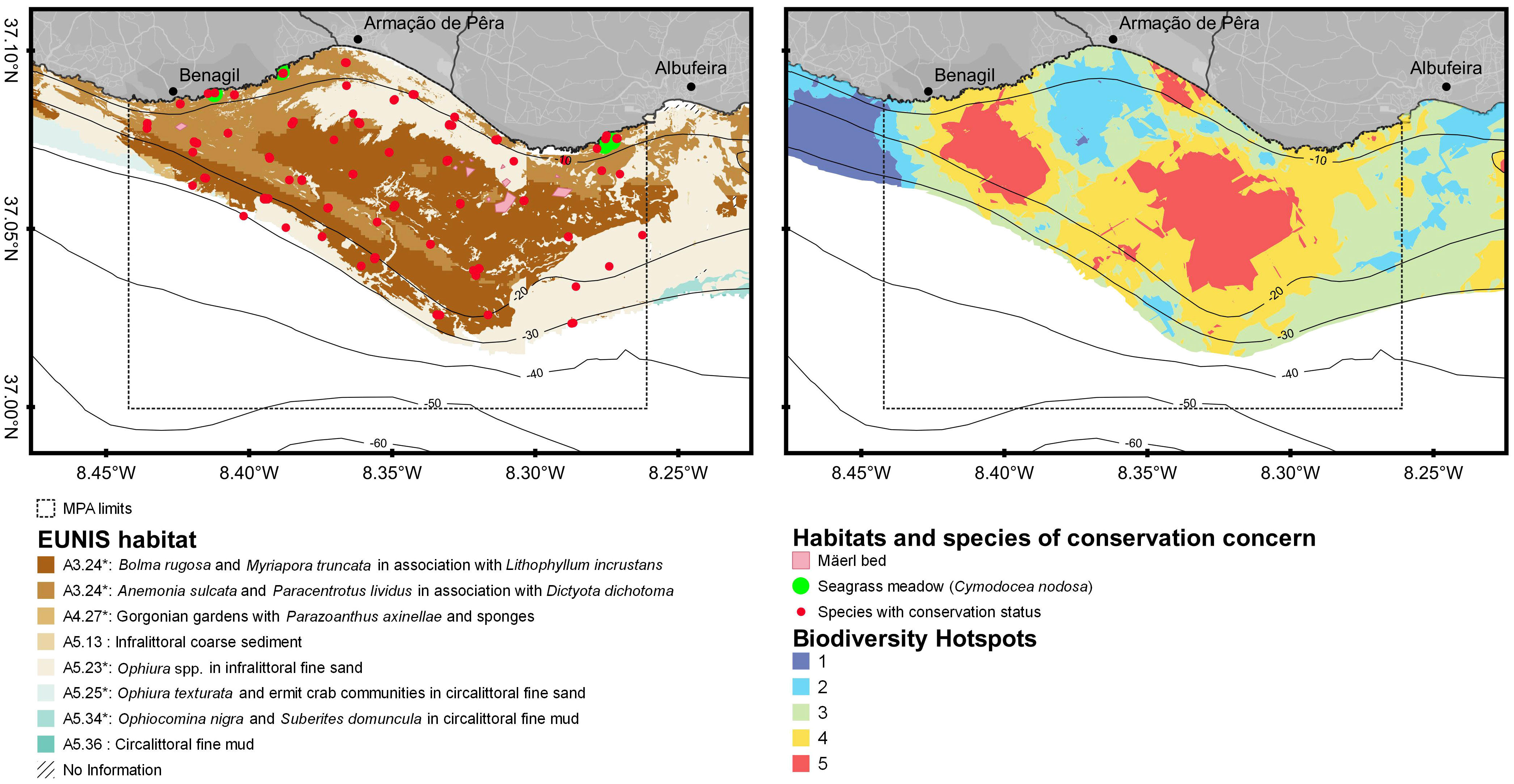
Figure 3 Maps of biotic habitats and natural values in the region of the future MPA (adapted from Gonçalves et al., 2016 and Sales Henriques et al., 2018): EUNIS habitats with vital ecological functions (include mixed gorgonian and sponge gardens, seagrass meadows, mäerl beds, also included in the OSPAR Convention) and species with conservation status (include the most threatened categories of the IUCN red list and Bern Convention/Habitats Directive; see Table S1, Supplementary Materials) – left panel; multi-component biodiversity index with five standardized levels (from 1 – the lowest, to 5 – the highest value), in which level 5 is considered a biodiversity hotspot– right panel. *New level 5 EUNIS habitats described for the Portuguese coast awaiting the definitive code.
The users’ map, developed with the participants’ contribution during the Users’ Mapping Workshop (Figure 4), shows that preferred sites for commercial fisheries extend throughout the region, are mainly distributed along the outside (offshore) limits of the rocky reef, but also some in the nearshore and in the rocky reef (Figure 4, top-left panel). Preferred sites for recreational fisheries are limited to the rocky shores and cliffs (land-based) or the reef crest and some prominent rocky outcrops, including deeper areas (boat-based; Figure 4, top-center panel). Marine tourism activities also selected sites closer to shore (e.g., coastal visits nearshore) or at specific rocky outcrops (e.g., recreational diving without catch) but these are concentrated in smaller areas (Figure 4 – top-right panel). The final users’ map, overlapping the activities’ preferred sites, shows that this region is used throughout its extent, with users’ hotspots (i.e., sites selected by two or the three activities) being in the nearshore and in the reef crest (Figure 4, bottom panel).
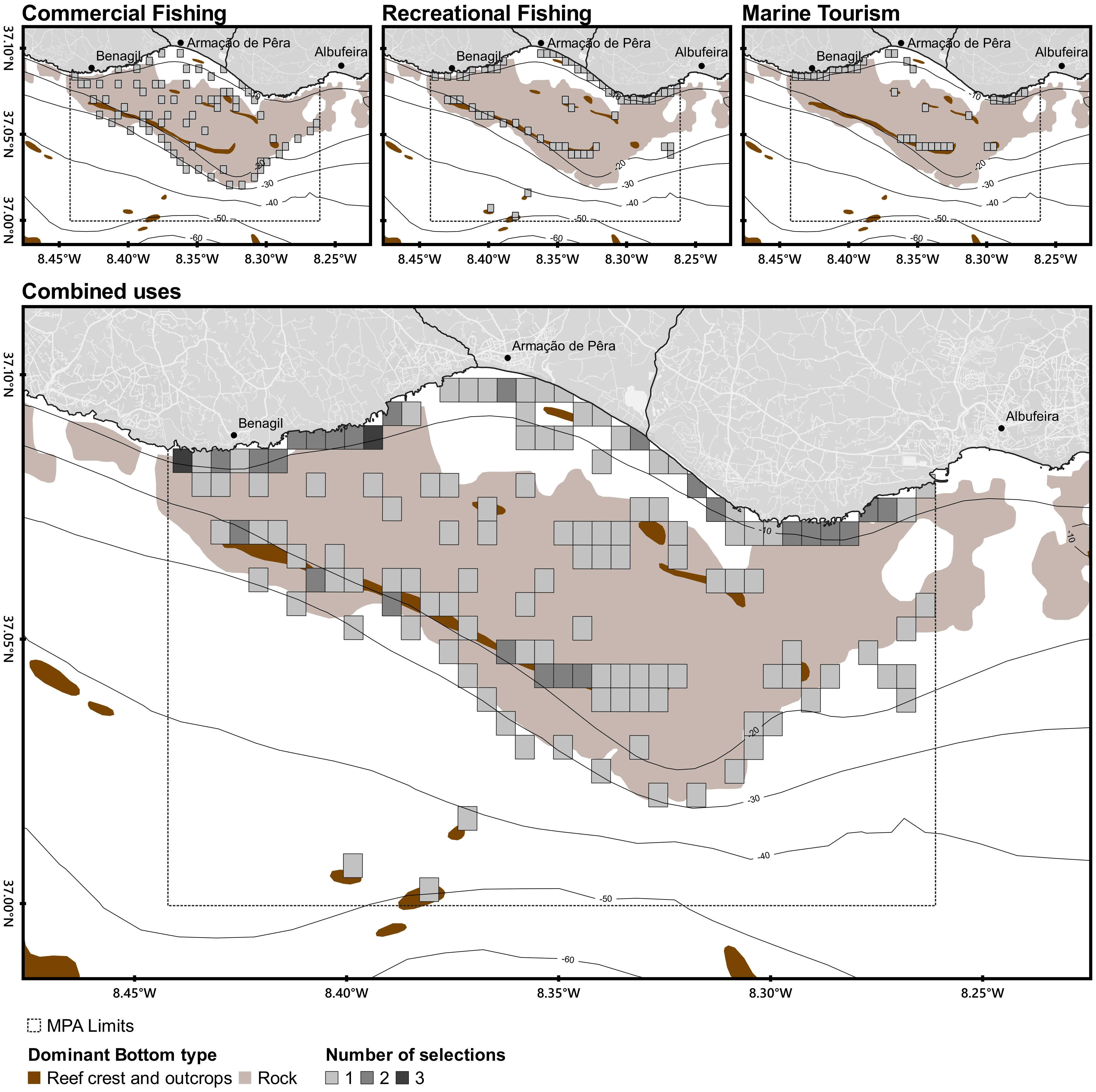
Figure 4 Priority sites of use (by the grid), according to the representatives of the local activities (commercial fisheries, top-left panel; recreational fisheries, top-centre panel; marine tourism businesses, top-right panel), selected during the users’ Mapping Workshop. Chosen sites were overlapped, resulting in the bottom panel map: light grey – selected by only one activity; grey – selected by two activities; dark grey – selected by the three activities. Sites selected by two or three activities are assumed as users’ hotspot.
Overlaying the biodiversity hotspots with the users’ maps shows a substantial overlap between uses and the areas with the highest biodiversity index (Figure 5). Balancing all the activities and interests in the zoning plan of the future MPA would prove to be challenging.
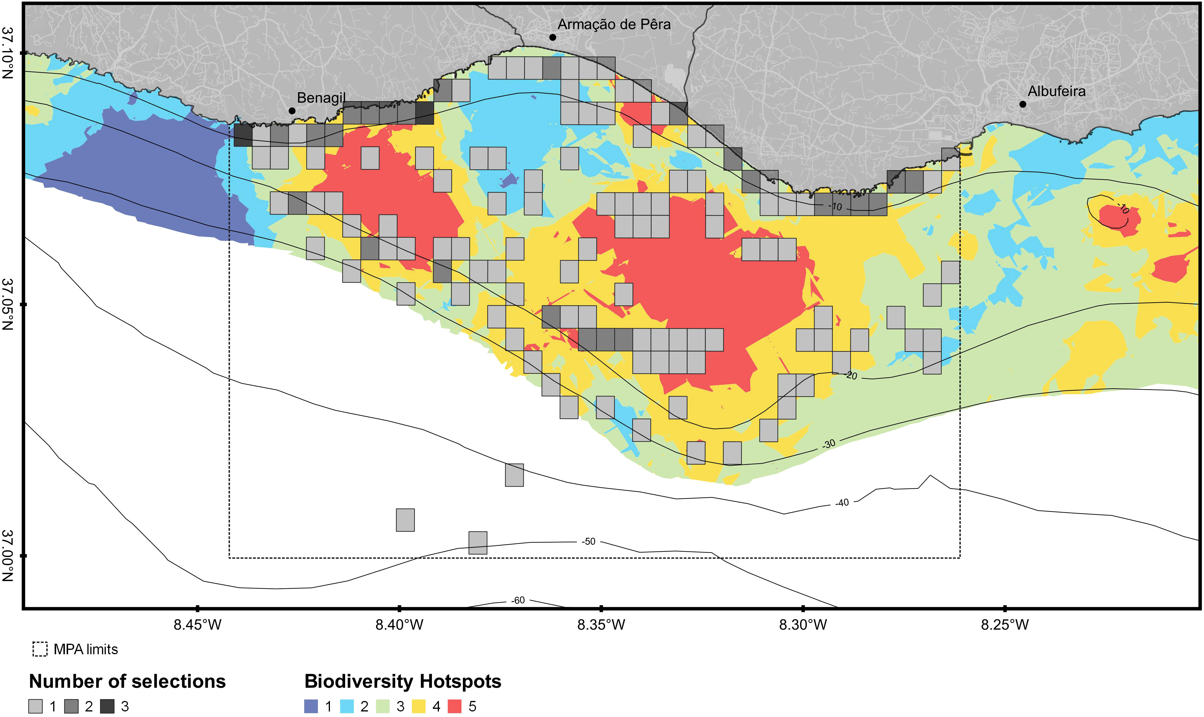
Figure 5 Overlap of the ecological features captured by the biodiversity hotspots and the users’ map in the region of the future MPA. See Figures 3, 4 for details on the number of selections and the biodiversity index.
First zoning proposal
The first zoning proposal shown at the First zoning workshop encompassed a 156.3km2 MPA and included relatively large no-take areas (~18.8km2) (Figure 6). In this proposal, four main zones were defined: i) a no-take/no-go area (NT/NG) (i.e., a fully protected area); ii) a no-take area with non-extractive recreational activities allowed (NT/A) (i.e., no-take/access) surrounding the no-take/no-go, iii) and a partially protected area (PPA) allowing only low-impact locally dependent (vessels LOA ≤7m) and highly selective gears of small-scale fisheries (longlines, jigging and traps) (positive discrimination), but no other extractive activities allowed, including recreational fisheries. A fourth zone, designated as a buffer area (BA), surrounded the previous zones occupying most of the MPA. Although this was the less protected zone, several extractive activities were still banned: sand dredging (only allowed for emergencies), aquaculture, bottom trawling (also forbidden in the first six nautical miles by the national fisheries law) and clam dredges, and purse seining shallower than 30m depth, to avoid [bottom/demersal] purse seining over the rocky reef. The three seagrass meadows’ habitats were not included in the most protected zones; that was highlighted as a topic to address in the future. See zones and regulation details in the Supplementary Material (Figure S1A).
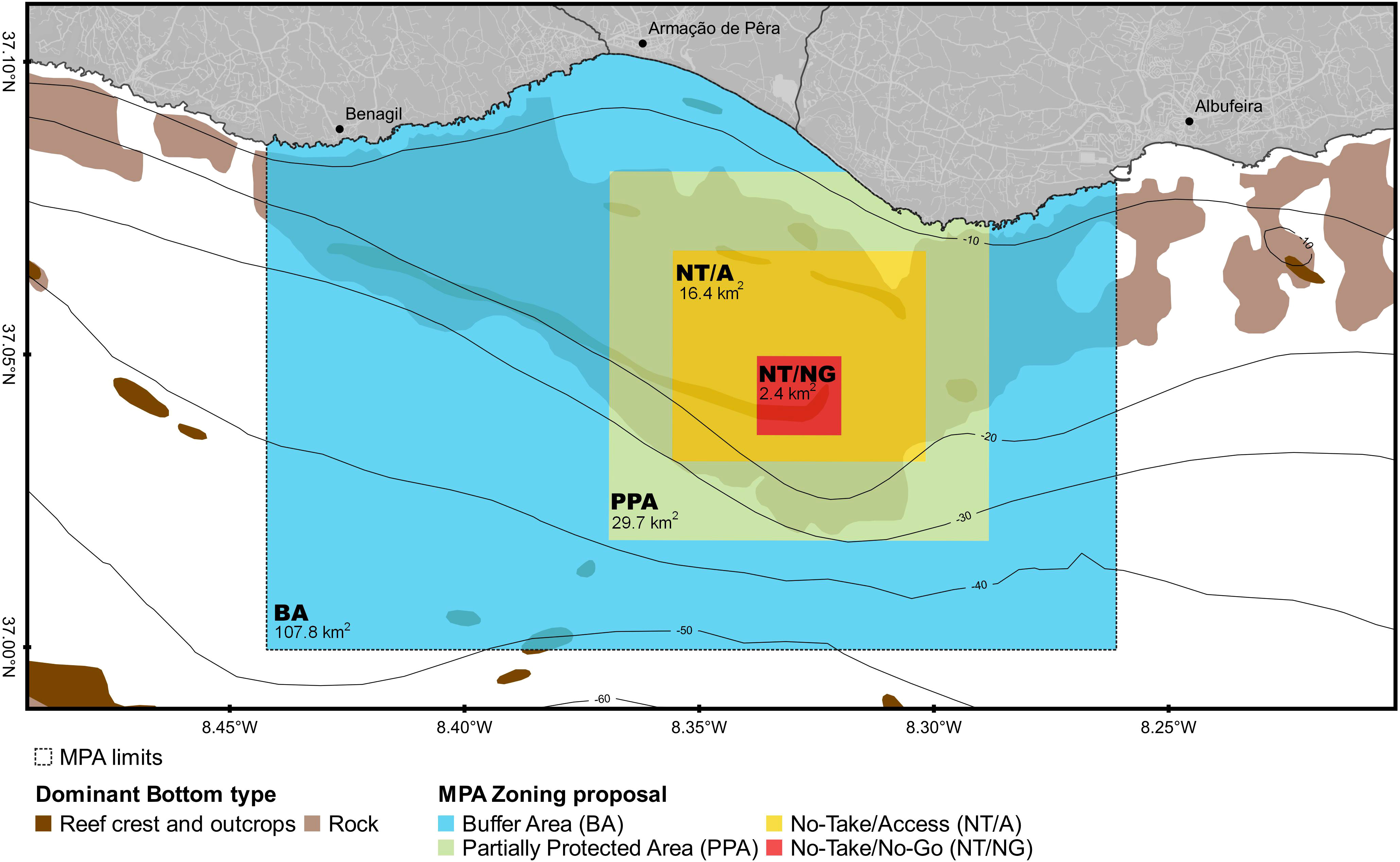
Figure 6 First proposal of MPA zoning and respective general regulations as presented in the First zoning workshop (3rd session of the multi-stakeholder workshops).
The main goal of this proposal was to protect the largest biodiversity hotspot and include a very good representation of the habitats from the shore to 30m depth.
This first zoning proposal was discussed in the First zoning workshop, and by the end of this interaction, it was clear that some adjustments were needed, mainly:
- Changes in the location, shape, and size of the no-take areas to encompass the whole reef crest (called “Pedra do Valado”), a symbolic physical feature of this region (Figures 2, 3);
- Removal of positive discrimination around the no-take areas as it was considered unfair by some commercial and recreational fishers’ associations.
Also, to further discuss specific issues and users’ concerns, several parallel meetings were requested. Hence, some stakeholders’ engagement meetings occurred before developing a new proposal.
Second zoning proposal
Considering users’ input and the zoning principles, a second zoning proposal was developed (Figure 7) and presented during the Intermediate zoning workshop. The main changes from the first proposal included:
- The exclusion of the partially protected area surrounding the no-take areas, eliminating the privileged access. To offset this exclusion, and as an attempt to reduce fishing effort and impacts in the whole inner part of the reef (nearshore and coastal area to 30m depth), fishing activities were limited to vessels under 7m length;
- The increase of the no-take/access area to include the reef crest and the western biodiversity hotspot;
- The increase in size of the no-take/no-go area.
This adjustment aimed at minimizing edge effects by offsetting the fact that, in the new proposal, the no-take areas were no longer surrounded by a partially protected area with a high protection level. In practice, the size of both no-take areas (~28.8km2) resulted in an increase of nearly 10km2 from the previous proposal.
- The inclusion of small special protection zones of intertidal and shallow habitats (e.g., rocky intertidal pools and seagrass meadows).
These small new zones were proposed to offset the lack of sensitive and important habitats within the no-take and highly protected areas. These include seagrass meadows (three areas – Seagrass Special Protection Area; specific regulations banned anchoring and extractive activities) and the rocky intertidal pools (one area, the largest one - Intertidal Special Protection Area; regulations banned all extractive fishing including land-based fishing, spearfishing and hand harvesting; Figure 7 and Supplementary Materials, Figure S1B).
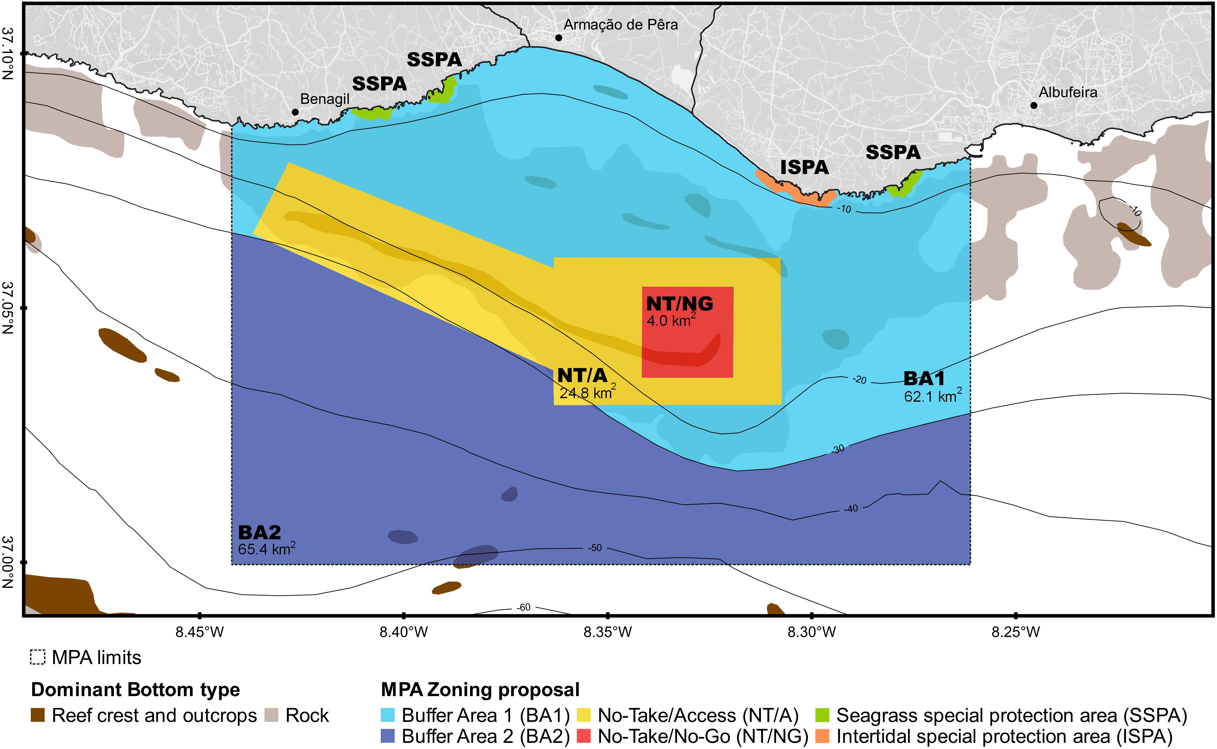
Figure 7 Second proposal of MPA zoning and respective general regulations as presented in the Intermediate zoning workshop (4th session of the multi-stakeholder workshops).
This second proposal was presented and discussed in the Intermediate zoning multi-stakeholder workshop. Although the overall layout was considered appropriate, two issues emerged:
- The request to extend the initial restriction of the 7m vessel size threshold for fishing in the inner part of the reef to 9m vessel size.
This change was non-consensual between stakeholders within the fishing sector. Some fishers’ associations argued that the previous threshold was unfair and unclear since the national fishing law uses the 9m length as the upper limit for the local fishing fleet segment (>9m length is considered coastal fisheries). The remaining associations still wanted to maintain the limitation of access to boats under 7m length so that fishing effort and resource competition would decrease in the area.
- The new location of the no-take/access area, encompassing the western area of the reef crest, faced strong opposition from a few local fishers. With this proposal, these fishers argued that they would lose their main fishing grounds since they operate in very small vessels and are established in nearby areas.
After this workshop, an extensive second round of specific stakeholders’ engagement meetings took place to further discuss this new zoning proposal. Discussions were focused on the following main points:
- The possibility of having 9m vessels fishing in the inner part of the reef;
- The loss of important fishing grounds above the reef crest by some fishers as, in this new proposal, they would be in a no-take/access area;
- The loss of fishing grounds in the inner part of the reef by coastal vessels (>9m), including some purse seiners that operate there;
- Appreciation of aquaculture banning: all stakeholders valued the fact that aquaculture was banned from the MPA, as it was previously planned to occur within its future borders2;
- The need to clarify other rules for some activities (e.g., recreational fisheries, navigation, and non-extractive activities);
- It was made clear that specific and more detailed regulations are still needed for some activities and that these should be discussed and implemented in the future. In the participatory process, a co-management body was suggested as the preferred governance model for this MPA.
Third and last zoning proposal
Consequently, considering all the users’ input received during late 2019 and most of 2020, the third and final proposal was developed iteratively. The concerns were addressed, with the main points being:
- local fishers (i.e., vessels up to 9m in length, excluding purse seiners) are allowed to fish in the inner part of the reef (buffer area 1), with the main consequence being the increase in fishing effort (in the participatory process, fishers’ associations reported ~ 130 vessels up to 9m in length using this region);
- coastal fishers (i.e., vessels >9m in length), including purse seiners, kept some of their fishing grounds shallower than 30m if in sandy or flat mixed habitats and in the outer part of the reef (buffer area 2);
- local fishers (≤9m vessel length) allowed to fish in the western tip of the reef crest by removing that part from the no-take/access area (i.e., shortening that area in that direction);
- the implementation of the no-take/access in a transitional phase (one half at a start and the second half after a certain period, ~1-3 years) to allow for adaptation and old fishers to retire.
To complement ecological data with socioeconomic information, a comprehensive valuation of the socioeconomic impact and mapping of the main activities occurring in the area was conducted (Ressurreição et al., 2020). Mapping and valuations exercises provided critical information to support the design of final zoning plans, help to establish trade-offs between conflicting uses, and unlock users’ negotiations, leveraging MPA social acceptability. In fact, during the final stages of the MPA participatory process, socioeconomic data improved the spatial configurations of the MPA zoning, influenced decisions regarding the types of activities allowed in each zone, and enhanced managers and stakeholders’ understanding of the trade-offs between development and conservation goals (Ressurreição et al., 2020).
All these suggestions were incorporated in a third and last zoning proposal presented during the online public presentation (Figure 8 and Supplementary Materials, Figure S1C) including four different types of zones:
- no-take/no-go – in the core of the biodiversity hotspot (4km2);
- no-take/access – in the reef crest (to be implemented in two phases) (~16km2);
- buffer area 1 – in the inner part of the reef, for local fisheries (vessels below 9m length) excluding purse seiners (~55km2);
- buffer area 2 – in the outer part of the reef, for all fisheries, except dredges and bottom trawling. Additional regulation for the other activities was kept from the first proposal (~81km2);
- four special areas on the nearshore – three small areas for seagrass meadows (Seagrass Special Protection Area) and one for the intertidal representativity and educational purposes (Intertidal Special Protection Area), all with little restrictions proposed (no-anchoring or no hand harvesting, respectively).
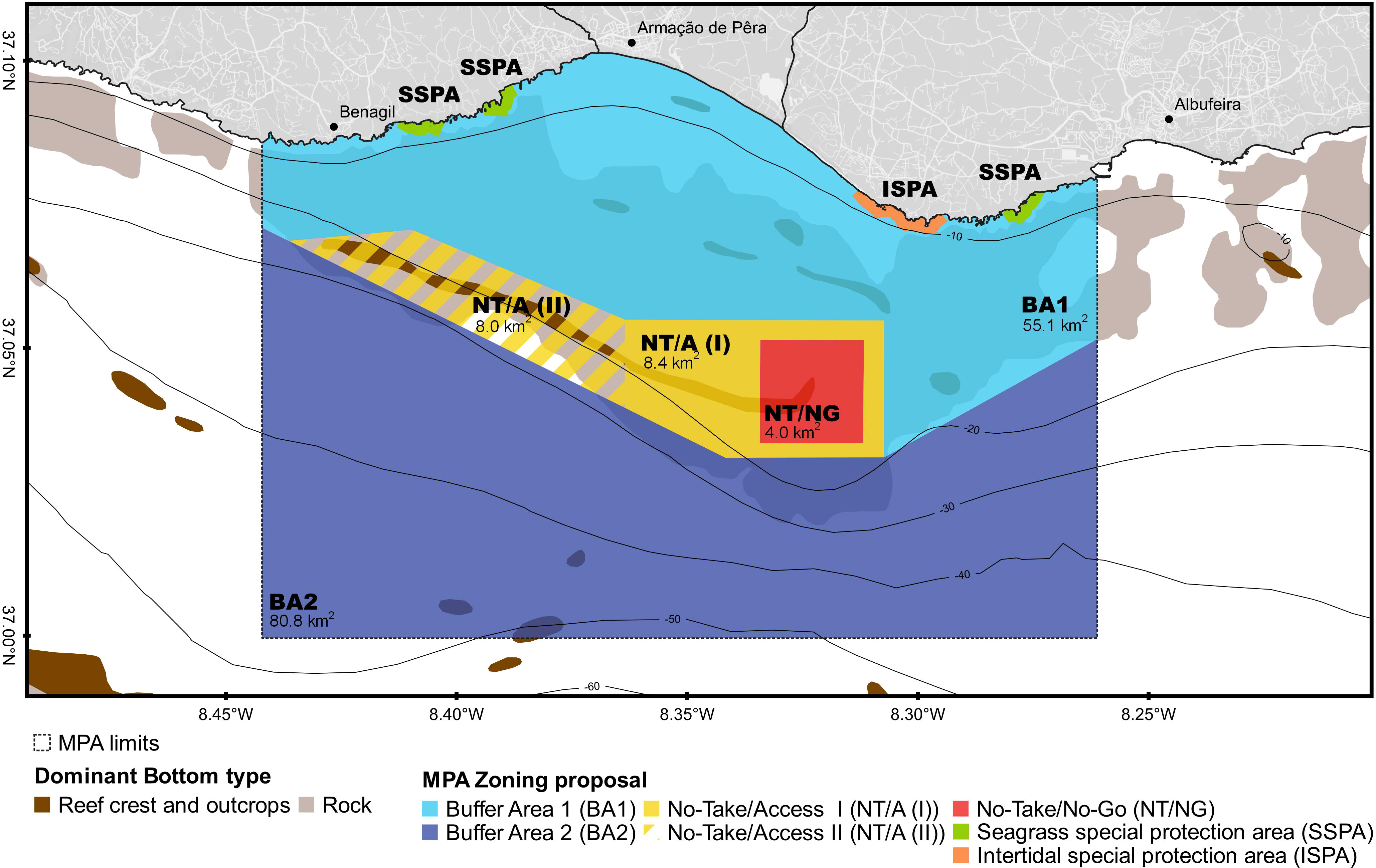
Figure 8 Third and last proposal of MPA zoning and respective general regulations as presented in the online public participation.
The resulting overall size of the no-take area (no-go and access combined, ~20km2) was slightly smaller than in the previous proposal, resulting from the need to accommodate specific fisheries requests, but still larger than in the first proposal. Nevertheless, the size of the no-take/no-go was kept between the second and the final proposals and was considered to have a size compatible with the conservation objectives.
After interactive zoning discussions during stakeholders’ engagement meetings, the final proposal was presented to the participants and the general public in an online public presentation. This was the chosen dissemination strategy, given the restrictions imposed by the covid pandemic. At the time, organizing an in-person multi-stakeholder workshop for more than 50 people was not feasible due to the health department restrictions. During the online event, participants still had the opportunity to raise questions and clarify remaining doubts. Further, they were asked to formulate a document with their position concerning the final proposal and to suggest additional changes if needed. The promoters informed that all the documents relative to the participatory process would be compiled into a final report to be delivered to the central government during 2021.
The vast majority of the stakeholders validated and supported the final proposal: 54 positions were delivered, 52 supportive, and two negatives (conditioned to compensatory measures). The official delivery to the government occurred in May 2021 in a dedicated event.
Compromises between proposals
Moving forward on the zoning exercise implied obvious compromises to accommodate proposed suggestions so that most stakeholders could endorse the final proposal. Going back to the guiding principles, we compared the three zoning proposals and demonstrate how the principles helped in navigating between trade-offs and complex negotiations. Table 1 summarizes the degree to which each zoning proposal met the selected zoning principles.
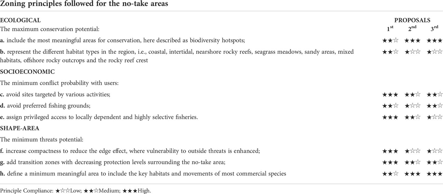
Table 1 Comparative analysis of the degree of compliance of zoning proposals following the pre-defined zoning principles.
Overall, including a large diversity of habitats (i.e., cross-shelf design, including nearshore to offshore habitats) within a continuous no-take area and surrounding highly protected area was the ecological guiding principle most affected in the final proposal. This shortcoming was offset by the creation of small nearshore special protection areas with specific measures to protect these habitats (e.g., anchoring ban in seagrass meadows or hand-harvesting ban in the rocky intertidal pools; Figure S1, Supplementary Materials). The seagrass meadows were fully encompassed by the respective special protection areas (Table S2, Supplementary Materials). The mäerl beds became included only in the buffer area 1, but no destructive bottom fisheries are allowed in this area. Another ecological principle affected was the extent of the highest biodiversity index (level 5) within the no-take areas, that decreased in the last proposal. Yet, a 40% of biodiversity hotspots was still encompassed within no-take areas (Table S2, Supplementary Materials). On the other hand, a key habitat for conservation, gorgonian and sponge dominated assemblages, was not incorporated within a no-take area in the first proposal, but was incorporated in the subsequent proposals and covered 56% of the MPA in the final proposal (Table S2, Supplementary Materials).
For the socioeconomic principle, the evolution of proposals led to more fishers’ preferred sites being included in the no-take area (access). Still, this option was requested and validated by most of the participants especially after slightly shrinking the western tip of the no-take/access. The privileged access had been considered unfair by some stakeholders, but the creation of two buffer areas, with distinct commercial fishing regulations, will potentially help to reduce the fishing effort and impacts on the rocky reef.
As for the shape-area principle, the edge effect increased through a more elongated shape compared to the earlier proposal, although it was compensated by an increase in the no-take/no-go size. The change in shape also meant that the two main biodiversity hotspots would now be connected, and most of the reef crest would be included in a continuous no-take area, avoiding fragmentation.
Lessons learned
A myriad of factors influenced the evolution of the zoning proposal. Critical decisions, sometimes with low immediate visibility, were central to the success and general support of the final proposal (Box 1). Some of these lessons were similarly suggested by Day (2017) and Day et al. (2019), whose studies cover the whole re-zoning participatory process of the GBRMPA. Yet, here those most responsible for the zoning achievements are highlighted in the context of this study, and how these specifically influenced the final zoning and associated process is explained. A detailed discussion of our main lessons is found in the following section.
BOX 1 - Lessons learned

Discussion
Here we highlight the steps and negotiations of the participatory co-design of a marine protected area (MPA) zoning. Despite all the challenges, when implemented, the fina zoning plan will allow achieving the main goals of the proposed community-initiative MPA, i.e., reaching ambitious conservation goals while attempting at minimizing the impacts on the existing economic activities. Importantly, this area is in the most intensely used region of the Algarve (Portugal), numerous participants attended the process, and the vast majority of the stakeholders supported the final proposal.
Two main components and their respective standards were adopted from the start: the widely recognized guiding principles for zoning (e.g., Roberts et al., 2003; Fernandes et al., 2005; Fernandes et al., 2009; Foley et al., 2010; Green et al., 2014), and the participatory approach designed and implemented by a skilled facilitator (von Wehrden et al., 2019; Guimarães and Herrera, 2021). Since the beginning, it was recognized the need to assemble a wide range of expertise within the promoters’ team. Hence, the team included experts in natural as well as social sciences, in association with the local knowledge derived from members of the fishing communities and of the local authorities. The design and implementation of a participatory process require expertise and resources (Hoffmann et al., 2022). As such, we started the process with key and transparent messages, highlighting the need for strong protection (e.g., including a no-take area) and the importance of its recognition by the local community. The best available scientific information provided the basis for a sound ecological design, identifying the most critical zones for conservation (i.e., ecological principles) (e.g., Roberts et al., 2001; Gaines et al., 2010; Green et al., 2014). To reduce negative socioeconomic impacts on the local communities (i.e., socioeconomic principles), knowledge derived from local users was also included from the early stages, emphasizing the legitimacy given to traditional and local uses (Dehens and Fanning, 2018). By asking for information from different sectors, the process recognized various sources of knowledge and created the space for exchange, which is central to achieve more acceptable decisions (Day, 2017). Different stakeholders’ knowledge was also useful when identifying ecologically important areas while planning MPAs in Wales (Ruiz-Frau et al., 2015). Indeed, stakeholder engagement with knowledge legitimacy underlies the acceptance and respect of the zoning and protection measures (Dehens and Fanning, 2018; Giakoumi et al., 2018).
Compromises were needed while attempting to follow the guiding zoning principles. Overall, including local knowledge did not jeopardize the application of the ecological guiding principles. On the contrary, it reinforced the suggested location of the no-take/no-go area. The change in the no-take/access position, size, and shape to include the reef crest suggested by most of the heterogenous groups in the first zoning workshop, was an ecologically reasonable alternative. This option can secure the most structurally complex area of the reef and connect the two largest ecological hotspots and a continuous habitat. The widespread distribution of key habitats for conservation precluded representing all within a continuous and compact no-take area. Yet, the main principle addressed, encompassing biodiversity hotspots, kept a reasonable coverage (40% of its range), according to the literature (Fernandes et al., 2005). Further, the gorgonian and sponge dominated assemblages and seagrass meadows benefitted from the final zoning. Yet, the rearrangement of the no-take/access area came at the expense of a greater edge effect, which led to the decision to increase the no-take areas (i.e., fully protected zones) to offset that disadvantage. Indeed, if this zoning is accepted and declared by the government, the resulting no-take area, totalling 20.4km2, will be the largest in mainland Portugal (Horta e Costa et al., 2019). The suggested change in this area’s position and shape also led to recognizing that relevant nearshore habitats with conservation interest could be left with less protection. Fruitful discussions about the usefulness of protecting such areas, associated with educational and awareness purposes, were relevant to inspire the participation of municipalities in creating special protection areas explicitly aimed at those habitats.
In the present case, the guiding zoning principles were crucial to highlight the trade-offs between proposals and to safeguard conservation needs. The identification of compromises also highlighted the potential need for revisions in the future, in case the current proposal does not allow the achievement of all goals set for this MPA.
Other processes have also highlighted the diversity of engagement moments and the importance of involving different institutions as central for success as well as for fairer and more equitable decisions (Giakoumi et al., 2018; Day et al., 2019; Schéré et al., 2021; Pinto-Correia et al., 2022). Yet, as Day (2017) highlighted, extensive public sessions can be less valuable than limited engagement sessions. We support this argument and, from start, sessions with clearly identified stakeholders – representatives of main activities and sectors in the region – were the option selected rather than working in a public setting. Nevertheless, the process was maintained open so that stakeholders not yet identified or integrated could, at any stage, step in. An example was the growing role of municipalities in mobilizing local stakeholders. Further, heterogeneous group discussions in multi-stakeholder workshops were complemented with stakeholder engagement meetings, representing discussions with homogenous groups. We consider this diversity an essential feature of our methodological approach, allowing a stepwise development of a zoning and regulation instrument supported by the majority. Still, it was surprising to us the amount of engagement meetings we had to undertake; therefore, resource allocation needs to be carefully planned. Undoubtedly, such resource allocation unblocked some early oppositions and encouraged participation, resulting in a better understanding and account of the various interests in the zoning design. The diversity of engagement meetings brought opportunities for valuable information and knowledge exchange while simultaneously building trust. They were vital to achieve compromises supported by the majority. Here, the flexibility and needed detachment of the technical/scientific team were also central to better managing the compromises and offsets that were accrued through time, reinforcing previous findings (Guimarães et al., 2015).
The consensus amongst participants has also been previously recognized as hard to achieve in complex processes such as this one (Day, 2017). As such, our approach was not focused on consensus but on compromises. Compromises are possibly the most important outcome of these processes, as concluded by previous studies describing similar participatory approaches for MPAs (re)zoning (Day, 2017). Successful compromises (i.e., supported by the majority) are only possible with large participation and engagement from the start, as well as transparency on the primary purpose of the zoning (e.g., placement of fully protected zones in the most ecologically meaningful areas to promote the maintenance of ecosystems services and uses). Some participatory approaches or co-management schemes succeed in building trust but have failed to adequately protect the ecosystems by not defining or clarifying the minimum outcomes expected from participants (e.g., Marine Parks in France) (Claudet et al., 2021). Yet, MPAs need to effectively address conservation issues with clear goals and transparency to succeed in both ecological and social components (Grorud-Colvert et al., 2021). On the other hand, soundly-based top-down MPA planning is typically perceived as unequal (i.e., unfair and non-inclusive), undermining the support and compliance of stakeholders and general users (Jones et al., 2013). Such an approach has been increasingly recognized as one of the main factors leading to MPA failure (Agardy et al., 2011; Giakoumi et al., 2018; Schéré et al., 2021).
With the implementation of a participatory approach by a scientific team with natural and social sciences expertise, one could balance ecological and socioeconomic interests; this has been suggested as one of the best approaches to co-design MPAs (Ruiz-Frau et al., 2015). In the Great Barrier Reef MPA (Australia), the (re)zoning initiative had clear conservation and social concerns due to the shortage of protection of the previous plan. It was co-designed with users, and after a challenging but fruitful participatory, inclusive process, the zoning plan could safeguard high protection levels in ecologically important zones while permitting sustainable use (Day et al., 2019). Several lessons came out of that process (Day, 2017; Day et al., 2019) and contributed to pave the way for similar processes, such as the one presented here. Yet, guidance on how to start and conduct a co-zoning process in small coastal MPAs where most of the activities are relatively well mapped but extremely intense and overlapping, is still poorly described elsewhere. Previous processes recognized that specific fisheries and tourism measures should complement zoning to attain more successful outcomes (Day et al., 2019). Here, an in-depth management plan is still to be developed, hopefully in a co-management approach (i.e., with representatives of the governmental management, conservation, fisheries, and tourism agencies, local municipalities, fishers’ and tourism associations, NGOs, and researchers), when the government declares this MPA. The existing national legislation on co-management of protected areas was approved in 2019, includes low management flexibility to the entities involved, and is yet to be applied in the marine environment (Cardoso-Andrade et al., 2022). Yet, national management authorities can share responsibilities with the local entities if they legitimate and incorporate their consultive deliberations in decision-making.
Previous studies underlined the need to change the common perception that MPAs burden coastal communities by highlighting the expected/potential benefits of well-designed MPAs (Balata and Williams, 2020). Yet, promising specific outcomes may deceive users and derail MPA achievements, so transparency and clarity are essential. Moreover, addressing the inequitable distribution of benefits (and burdens) in MPA zoning is also seen as a priority for stakeholders’ willingness to support MPAs (Schéré et al., 2021). This will need further consideration in the current MPA implementation process as it was highlighted by stakeholders. Reframing how communities perceive marine conservation is still widely neglected but is central for MPA support and compliance. It includes legitimizing the roles of the community ensuring equity through co-management and stakeholder engagement (Giakoumi et al., 2018; Balata and Williams, 2020).
Further, zoning provides the basis of MPA management and is also a political process that needs to be embraced and implemented by political will and actions (Day et al., 2019). The approval of this MPA was recently announced by the Portuguese government (Horta e Costa et al., 2022), which recognized the relevance of this innovative participatory approach in the national context, the solid scientific background (e.g., marine habitat mapping), the negotiations among the stakeholders, their extensive support of the final zoning, and the guiding principles followed. Expectations are high as to the likely implementation of this zoning plan in the near future. The co-management of this MPA is also desirable for the future to allow the continuity of this novel process and the support and compliance of local users.
We believe this process is useful and can guide future MPA implementation or rezoning. Particularly, for relatively small coastal MPAs with numerous and overlapping small-scale activities that are not well understood. Though time and resource-consuming, these processes represent hope for successful conservation efforts such as MPAs. International ocean conservation strategies, such as the European Biodiversity Strategy for 2030, the Sustainable Development Goals for 2030, or the post-2020 CBD targets, commit countries to increase both the quantity and quality of MPAs. Transdisciplinary and participatory processes leading to zoning plans and regulations representing compromises that address both conservation and social goals, and stakeholders’ support, are crucial to achieving MPA effectiveness.
Data availability statement
The original contributions presented in the study are included in the article/Supplementary Material. Further inquiries can be directed to the corresponding author.
Author contributions
This study was designed by BHC, MHG, MR, AR and JMSG. All authors contributed to the design of the zoning proposals (particularly BHC, MR, AR, JMSG, PM, FO, LB) and/or to the participatory process. BHC wrote the manuscript with MHG, MR, AR and JMSG. FO produced the figures. All authors contributed to the article and approved the submitted version.
Funding
This study received funding from the Portuguese FCT – Foundation for Science and Technology to CCMAR through the strategic projects UIDB/04326/2020, UIDP/04326/2020 and LA/P/0101/2020. This study was also partially funded by National Funds through FCT - Foundation for Science and Technology under the Project UIDB/05183/2020 (MED) and UIDB/MAR/04292/2020, UIDP/MAR/04292/2020, UID/MAR/04292/2018/2019 (MARE-ISPA). This work was also supported by the Oceano Azul Foundation, namely the review study, socioeconomic evaluation and participatory process (AMPIC VALUE). BHC was supported by national funds through FCT - Foundation for Science and Technology, I.P. (Portugal), in agreement with the University of Algarve, in the scope of Norma Transitória with the research contract DL57/2016/CP1361/CT0038. MR and AR were supported by FCT through the postdoctoral fellowships SFRH/BPD/116307/2016 and SFRH/BPD/102494/2014, respectively. AB, MC-A and NSH were supported by FCT through doctoral grants (UI/BD/151307/2021; PD/BD/143087/2018 and ID:2020.05583.BD, respectively). Funding for marine habitat mapping was supported by CCDR-Algarve and ARH-Algarve.
Acknowledgments
We would like to greatly thank the three municipalities (Albufeira, Lagoa and Silves) and parish councils included in the MPA territory as well as all the participants in this process, namely the Portuguese government, through national and regional administration for nature conservation and fisheries management and to the fishers and nautical tourism operators associations. Without their commitment and interest, this initiative would have never been possible. We want to acknowledge all the researchers and students involved in the scientific studies and participatory process. We also want to thank the reviewers for their very interesting and useful suggestions that contributed to substantially improve the manuscript.
Conflict of interest
The authors declare that the research was conducted in the absence of any commercial or financial relationships that could be construed as a potential conflict of interest.
The reviewer JD declared a past co-authorship with several of the authors. BHC and JMSG to the handling Editor.
Publisher’s note
All claims expressed in this article are solely those of the authors and do not necessarily represent those of their affiliated organizations, or those of the publisher, the editors and the reviewers. Any product that may be evaluated in this article, or claim that may be made by its manufacturer, is not guaranteed or endorsed by the publisher.
Supplementary material
The Supplementary Material for this article can be found online at: https://www.frontiersin.org/articles/10.3389/fmars.2022.969234/full#supplementary-material
Footnotes
- ^ https://www.ccmar.ualg.pt/page/area-marinha-protegida-de-interesse-comunitario-do-algarve.
- ^ Aquaculture was initially planned to occur in the future area of this MPA by the National Marine Spatial Planning zoning. In the beginning of the participatory process, the promoters organized themselves to request its ban from this highly sensitive region (both ecologically and socially) to national agencies by submitting a position in a public consultation process. This has contributed to effectively banning offshore aquaculture from this specific area.
References
Agardy T., di Sciara G. N., Christie P. (2011). Mind the gap: Addressing the shortcomings of marine protected areas through large scale marine spatial planning. Mar. Policy 35 (2), 226–232. doi: 10.1016/j.marpol.2010.10.006
Appelstrand M. (2002). Participation and societal values: The challenge for lawmakers and policy practitioners. For. Policy Economics 4 (4), 281–290. doi: 10.1016/S1389-9341(02)00070-9
Balata F., Williams C. (2020). “The role of coastal communities in the sustainable management of marine protected areas,” In Humphreys J., Clark R. W. E.(Ed.) (Marine Protected Areas, Science Policy and Management:Elsevier), 113–129. doi: 10.1016/B978-0-08-102698-4.00006-X
Ban N. C., Adams V., Pressey R. L., Hicks J. (2011). Promise and problems for estimating management costs of marine protected areas: Management costs of marine protected areas. Conserv. Lett. 4 (3), 241–252. doi: 10.1111/j.1755-263X.2011.00171.x
Ban N. C., Gurney G. G., Marshall N. A., Whitney C. K., Mills M., Gelcich S., et al. (2019). Well-being outcomes of marine protected areas. Nat. Sustainability 2 (6), 524–532. doi: 10.1038/s41893-019-0306-2
Cardoso-Andrade M., Queiroga H., Rangel M., Sousa I., Belackova A., Bentes L., et al. (2022). Setting performance indicators for coastal marine protected areas: An expert-based methodology. Front. Mar. Sci. 9. doi: 10.3389/fmars.2022.848039
Chollett I., Box S. J., Mumby P. J. (2016). Quantifying the squeezing or stretching of fisheries as they adapt to displacement by marine reserves: Reserve effects on fishing activity. Conserv. Biol. 30 (1), 166–175. doi: 10.1111/cobi.12573
Claudet J., Loiseau C., Pebayle A. (2021). Critical gaps in the protection of the second largest exclusive economic zone in the world. Mar. Policy 124, 104379. doi: 10.1016/j.marpol.2020.104379
Day J. C. (2017). Effective public participation is fundamental for marine conservation–lessons from a Large-scale MPA. Coast. Manage. 45 (6), 470–486. doi: 10.1080/08920753.2017.1373452
Day J. C., Kenchington R. A., Tanzer J. M., Cameron D. S. (2019). Marine zoning revisited: How decades of zoning the great barrier reef has evolved as an effective spatial planning approach for marine ecosystem-based management. Aquat. Conservation: Mar. Freshw. Ecosyst. 29 (S2), 9–32. doi: 10.1002/aqc.3115
Dehens L. A., Fanning L. M. (2018). What counts in making marine protected areas (MPAs) count? the role of legitimacy in MPA success in Canada. Ecol. Indic. 86, 45–57. doi: 10.1016/j.ecolind.2017.12.026
Di Lorenzo M., Guidetti P., Di Franco A., Calò A., Claudet J. (2020). Assessing spillover from marine protected areas and its drivers: A meta-analytical approach. Fish Fisheries 21 (5), 906–915. doi: 10.1111/faf.12469
Dovers S., Feary S., Martin A., McMillan L., Morgan D., Tollefson M. (2015). “Engagement and participation in protected area management: Who, why, how and when?,” In Worboys G. L., Lockwood M., Kothari A., Feary S., Pulsford I. (eda) Protected area governance and management (Canberra:ANU Press). doi: 10.22459/PAGM.04.2015.14
Edgar G. J., Stuart-Smith R. D., Willis T. J., Kininmonth S., Baker S. C., Banks S., et al. (2014). Global conservation outcomes depend on marine protected areas with five key features. Nature 506 (7487), 216–220. doi: 10.1038/nature13022
Fernandes L., Day J., Kerrigan B., Breen D., De’ath G., Mapstone B., et al. (2009). A process to design a network of marine no-take areas: Lessons from the great barrier reef. Ocean Coast. Manage. 52 (8), 439–447. doi: 10.1016/j.ocecoaman.2009.06.004
Fernandes L., Day J., Lewis A., Slegers S., Kerrigan B., Breen D., et al. (2005). Establishing representative no-take areas in the great barrier reef: Large-scale implementation of theory on marine protected areas. Conserv. Biol. 19 (6), 1733–1744. doi: 10.1111/j.1523-1739.2005.00302.x
Fidler R. Y., Ahmadia G. N., Amkieltiela, Awaludinnoer, Cox C., Estradivari, et al. (2022). Participation, not penalties: Community involvement and equitable governance contribute to more effective multiuse protected areas. Sci. Adv. 8 (18), eabl8929. doi: 10.1126/sciadv.abl8929
Foley M. M., Halpern B. S., Micheli F., Armsby M. H., Caldwell M. R., Crain C. M., et al. (2010). Guiding ecological principles for marine spatial planning. Mar. Policy 34 (5), 955–966. doi: 10.1016/j.marpol.2010.02.001
Gaines S. D., White C., Carr M. H., Palumbi S. R. (2010). Designing marine reserve networks for both conservation and fisheries management. Proc. Natl. Acad. Sci. 107 (43), 18286–18293. doi: 10.1073/pnas.0906473107
Giakoumi S., McGowan J., Mills M., Beger M., Bustamante R. H., Charles A., et al. (2018). Revisiting “Success” and “Failure” of marine protected areas: A conservation scientist perspective. Front. Mar. Sci. 5. doi: 10.3389/fmars.2018.00223
Giakoumi S., Scianna C., Plass-Johnson J., Micheli F., Grorud-Colvert K., Thiriet P., et al. (2017). Ecological effects of full and partial protection in the crowded Mediterranean Sea: A regional meta-analysis. Sci. Rep. 7 (1), 8940. doi: 10.1038/s41598-017-08850-w
Gleason M., McCreary S., Miller-Henson M., Ugoretz J., Fox E., Merrifield M., et al. (2010). Science-based and stakeholder-driven marine protected area network planning: A successful case study from north central California. Ocean Coast. Manage. 53 (2), 52–68. doi: 10.1016/j.ocecoaman.2009.12.001
Gonçalves J. M. S., Monteiro P., Bentes L., Oliveira F., Afonso C. M. L., Henriques N. S., et al. (2016). “Construindo mapas de habitats e da biodiversidade marinha,” in A Europa e o mar: Inovação e investigação cientifica em Portugal (Universidade do Algarve), 13. Available at: https://sapientia.ualg.pt/bitstream/10400.1/12862/1/Livro%20Final%2029%20julho.pdf.
Green A. L., Fernandes L., Almany G., Abesamis R., McLeod E., Aliño P. M., et al. (2014). Designing marine reserves for fisheries management, biodiversity conservation, and climate change adaptation. Coast. Manage. 42 (2), 143–159. doi: 10.1080/08920753.2014.877763
Grorud-Colvert K., Sullivan-Stack J., Roberts C., Constant V., Horta e Costa B., Pike E. P., et al. (2021). The MPA guide: A framework to achieve global goals for the ocean. Science 373 (6560), eabf0861. doi: 10.1126/science.abf0861
Guidetti P., Bussotti S., Pizzolante F., Ciccolella A. (2010). Assessing the potential of an artisanal fishing co-management in the marine protected area of torre guaceto (southern Adriatic Sea, SE Italy). Fisheries Res. 101 (3), 180–187. doi: 10.1016/j.fishres.2009.10.006
Guimarães M. H., Herrera P. M. (2021). “Multi-actor platforms as a mechanism for actively bringing together actors and their interests,” in Governance for Mediterranean silvopastoral systems (Routledge). doi: 10.4324/9781003028437
Guimarães M. H., McKee A., Lima M. L., Vasconcelos L., Boski T., Dentinho T. (2015). Putting transdisciplinarity into practice: A mixed mode procedure for stakeholder participation in natural resource management. J. Environ. Plann. Manage. 58 (10), 1827–1852. doi: 10.1080/09640568.2014.964850
Halpern B. S., Lester S. E., McLeod K. L. (2010). Placing marine protected areas onto the ecosystem-based management seascape. Proc. Natl. Acad. Sci. United States America 107 (43), 18312–18317. doi: 10.1073/pnas.0908503107
Hoffmann S., Deutsch L., Klein J. T., O’Rourke M. (2022). Integrate the integrators! a call for establishing academic careers for integration experts. Humanities Soc. Sci. Commun. 9 (1), 1–10. doi: 10.1057/s41599-022-01138-z
Hogg K., Noguera-Méndez P., Semitiel-García M. (2021). Lessons from three north-western Mediterranean MPAs: A governance analysis of port-cros national park, tavolara punta-coda cavallo and ustica. Mar. Policy 127, 102943. doi: 10.1016/j.marpol.2017.10.034
Horta e Costa B., Batista M. I., Gonçalves L., Erzini K., Caselle J. E., Cabral H. N., et al. (2013). Fishers’ behaviour in response to the implementation of a marine protected area. PloS One 8 (6), e65057. doi: 10.1371/journal.pone.0065057
Horta e Costa B., Gonçalves J. M., dos S., Franco G., Erzini K., Furtado R., et al. (2019). Categorizing ocean conservation targets to avoid a potential false sense of protection to society: Portugal as a case-study. Mar. Policy 108, 103553. doi: 10.1016/j.marpol.2019.103553
Horta e Costa B., Gonçalves J. M. S., Gonçalves E. J. (2022). UN Ocean conference needs transparent and science-based leadership on ocean conservation. Mar. Policy 143, 105197. doi: 10.1016/j.marpol.2022.105197
Jones P. J. S., Qiu W., De Santo E. M. (2013). Governing marine protected areas: Social–ecological resilience through institutional diversity. Mar. Policy 41, 5–13. doi: 10.1016/j.marpol.2012.12.026
Maynard J. A., Beeden R., Puotinen M., Johnson J. E., Marshall P., van Hooidonk R., et al. (2016). Great barrier reef no-take areas include a range of disturbance regimes. Conserv. Lett. 9 (3), 191–199. doi: 10.1111/conl.12198
McGowan J., Bode M., Holden M. H., Davis K., Krueck N. C., Beger M., et al. (2018). Ocean zoning within a sparing versus sharing framework. Theor. Ecol. 11 (2), 245–254. doi: 10.1007/s12080-017-0364-x
McLeod E., Salm R., Green A., Almany J. (2009). Designing marine protected area networks to address the impacts of climate change. Front. Ecol. Environ. 7 (7), 362–370. doi: 10.1890/070211
Monteiro P., Bentes L., Oliveira F., Afonso C. M. L., Henriques N. S., Rangel M., et al. (2013). Atlantic Area EUNIS habitats. adding new habitat types from European Atlantic coast to the EUNIS habitat classification (Faro, Portugal: CCMAR, Universidade do Algarve), 61. Available at: https://sapientia.ualg.pt/handle/10400.1/8695. Technical Report No.3/2013 - MeshAtlantic.
Ohayon S., Granot I., Belmaker J. (2021). A meta-analysis reveals edge effects within marine protected areas. Nat. Ecol. Evol. 5 (9), 1301–1308. doi: 10.1038/s41559-021-01502-3
OSPAR (2010a). OSPAR - biodiversity series. background document for maërl beds (OSPAR Commission). 2010. Publication number: 491. Available at: https://www.ospar.org/documents?v=7221.
OSPAR (2010b). OSPAR - biodiversity series. background document for cymodocea meadows (OSPAR Commission). 2010. Publication number: 487. Available at: https://www.ospar.org/documents?v=7217.
Pinto-Correia T., Ferraz-de-Oliveira I., Guimarães M. H., Sales-Baptista E., Pinto-Cruz C., Godinho C., et al. (2022). Result-based payments as a tool to preserve the high nature value of complex silvo-pastoral systems: Progress toward farm-based indicators. Ecol. Soc. 27 (1), 39. doi: 10.5751/ES-12973-270139
Ressurreição A., Rangel M., Oliveira F., Monteiro P., Bentes L., Pontes J., et al. (2020). AMPICvalue–mapeamento e valoração das atividades suportadas pela costa de lagoa, silves e albufeira e desenvolvimento de um processo participativo com vista ao estabelecimento de uma Área marinha protegida de interesse comunitário (AMPIC) (Faro, Portugal: CCMAR, Universidade do Algarve, Fundação Oceano Azul), 162. Available at: https://www.ccmar.ualg.pt/sites/ccmar.ualg.pt/files/files/Docs_ASP/2020_ampicvalue_finalreport_13thapril2021.pdf.
Roberts C. M., Andelman S., Branch G., Bustamante R. H., Carlos Castilla J., Dugan J., et al. (2003). Ecological criteria for evaluating candidate sites for marine reserves. Ecol. Appl. 13 (sp1), 199–214. doi: 10.1890/1051-0761(2003)013[0199:ECFECS]2.0.CO;2
Roberts C. M., Halpern B., Palumbi S. R., Warner R. R. (2001). Designing marine reserve networks why small, isolated protected areas are not enough. Conserv. Pract. 2 (3), 10–17. doi: 10.1111/j.1526-4629.2001.tb00012.x
Ruiz-Frau A., Possingham H. P., Edwards-Jones G., Klein C. J., Segan D., Kaiser M. J. (2015). A multidisciplinary approach in the design of marine protected areas: Integration of science and stakeholder based methods. Ocean Coast. Manage. 103, 86–93. doi: 10.1016/j.ocecoaman.2014.11.012
Russi D. (2020). Governance strategies for a successful marine protected area – the case of torre guaceto. Mar. Policy 115, 103849. doi: 10.1016/j.marpol.2020.103849
Sala E., Giakoumi S. (2018). No-take marine reserves are the most effective protected areas in the ocean. ICES J. Mar. Sci. 75 (3), 1166–1168. doi: 10.1093/icesjms/fsx059
Sales Henriques N., Ressurreição A., Oliveira F., Monteiro P., Rangel M., Bentes L., et al. (2018) (Fundação Oceano Azul, Faro, Portugal: CCMAR, Universidade do Algarve). Available at: https://www.ccmar.ualg.pt/sites/ccmar.ualg.pt/files/relatorio_informacao_de_base_biodiversidade_e_usos_ualg_ccmar_ampic.pdf.
Schéré C. M., Schreckenberg K., Dawson T. P., Jones N. (2021). It’s just conservation: To what extent are marine protected areas in the Irish Sea equitably governed and managed? Front. Mar. Sci. 8. doi: 10.3389/fmars.2021.668919
Sciberras M., Jenkins S. R., Mant R., Kaiser M. J., Hawkins S. J., Pullin A. S. (2015). Evaluating the relative conservation value of fully and partially protected marine areas. Fish Fisheries 16 (1), 58–77. doi: 10.1111/faf.12044
Turnbull J. W., Johnston E. L., Clark G. F. (2021). Evaluating the social and ecological effectiveness of partially protected marine areas. Conserv. Biol. 35 (3), 921–932. doi: 10.1111/cobi.13677
von Wehrden H., Guimarães M. H., Bina O., Varanda M., Lang D. J., John B., et al. (2019). Interdisciplinary and transdisciplinary research: Finding the common ground of multi-faceted concepts. Sustainability Sci. 14 (3), 875–888. doi: 10.1007/s11625-018-0594-x
Voyer M., Gladstone W., Goodall H. (2012). Methods of social assessment in marine protected area planning: Is public participation enough? Mar. Policy 36 (2), 432–439. doi: 10.1016/j.marpol.2011.08.002
Weekers D., Petrossian G., Thiault L. (2021). Illegal fishing and compliance management in marine protected areas: A situational approach. Crime Sci. 10 (1), 9. doi: 10.1186/s40163-021-00145-w
Worm B., Barbier E. B., Beaumont N., Duffy J. E., Folke C., Halpern B. S., et al. (2006). Impacts of biodiversity loss on ocean ecosystem services. Science 314 (5800), 787–790. doi: 10.1126/science.1132294
Keywords: marine protected area (MPA), participatory approaches, stakeholder engagement, co-design, zoning, guiding principles, transdisciplinary
Citation: Horta e Costa B, Guimarães MH, Rangel M, Ressurreição A, Monteiro P, Oliveira F, Bentes L, Sales Henriques N, Sousa I, Alexandre S, Pontes J, Afonso CML, Belackova A, Marçalo A, Cardoso-Andrade M, Correia AJ, Lobo V, Gonçalves EJ, Pitta e Cunha T and Gonçalves JMS (2022) Co-design of a marine protected area zoning and the lessons learned from it. Front. Mar. Sci. 9:969234. doi: 10.3389/fmars.2022.969234
Received: 14 June 2022; Accepted: 05 October 2022;
Published: 10 November 2022.
Edited by:
Stelios Katsanevakis, University of the Aegean, GreeceReviewed by:
Jon C. Day, James Cook University, AustraliaGiuliana Marletta, University of Catania, Italy
Copyright © 2022 Horta e Costa, Guimarães, Rangel, Ressurreição, Monteiro, Oliveira, Bentes, Sales Henriques, Sousa, Alexandre, Pontes, Afonso, Belackova, Marçalo, Cardoso-Andrade, Correia, Lobo, Gonçalves, Pitta e Cunha and Gonçalves. This is an open-access article distributed under the terms of the Creative Commons Attribution License (CC BY). The use, distribution or reproduction in other forums is permitted, provided the original author(s) and the copyright owner(s) are credited and that the original publication in this journal is cited, in accordance with accepted academic practice. No use, distribution or reproduction is permitted which does not comply with these terms.
*Correspondence: Barbara Horta e Costa, YmJjb3N0YUB1YWxnLnB0
†These authors have contributed equally to this work