 Bekalu W. Asres
 Mebrahtom G. Kebedew
 Meareg D. Nerae
 Seneshaw Tsegaye
 Fasikaw A. Zimale
- 1School of Civil and Water Resource Engineering, Debre Markos Institute of Technology, Debre Markos University, Debre Markos, Ethiopia
- 2Department of Bioengineering, Civil Engineering and Environmental Engineering, U.A. Whitaker College of Engineering, Florida Gulf Coast University, Fort Myers, FL, United States
- 3School of Civil Engineering, Ethiopian Institute of Technology-Mekelle, Mekelle University, Mekelle, Ethiopia
- 4Faculty of Civil and Water Resources Engineering, Bahir Dar Institute of Technology, Bahir Dar University, Bahir Dar, Ethiopia
Intensified agriculture practices contribute to nutrient enrichment in freshwater lakes, causing eutrophication, algal blooms, and water hyacinth infestations. Eutrophication in Lake Tana, the source of the Blue Nile in Ethiopia, necessitates effective monitoring due to rapid infestation of water hyacinths. While traditional monitoring is costly and limited in spatial and temporal coverage, remote sensing offers a promising alternative. This study develops a regression model to estimate Chlorophyll-a (Chl-a) concentration using in situ and remote sensing reflectance data. Field measurements from 143 locations across Lake Tana were used to validate the correlation equations. Results show that the Moderate Resolution Imaging Spectroradiometer (MODIS) in near-infrared reflectance exhibits the strongest linear relationship with in situ Chl-a measurements for August 2016 (r2 = 0.53), December 2016 (r2 = 0.56) and March 2017 (r2 = 0.61). The developed models were validated with a root-mean-square error of 2.76 μg/L, 5.89 μg/L, and 8.04 μg/L for August, December, and March, respectively. Applying the developed model from 2008–2018, the Chl-a concentration of the lake indicated an increasing trend, likely driven by non-point sources from surrounding watersheds, causing infestation of the lake by hyacinths since 2011. The agreement between MODIS and in situ Chl-a data, coupled with the satisfactory performance of the linear regression model, underscores that developing a regression model for Chl-a estimation from remote sensing in water hyacinth-infested lakes is a useful method in tracking spatiotemporal variations. This study will serve as a foundation for future Chl-a variation studies in Lake Tana and other similar lakes.
1 Introduction
Elevated Chl-a levels often indicate nutrient enrichment in freshwater lakes, causing eutrophication (Shi et al., 2022). This nutrient overloading, driven by anthropogenic impacts, can lead to harmful algal blooms, infestation of water hyacinths, oxygen depletion, and ecological imbalances (Palmer et al., 2015). While effective management of Chl-a requires substantial data collection, the conventional Chl-a determination methods are expensive and time-consuming (Gholizadeh et al., 2016). To address these limitations, utilizing remote sensing for water quality assessment has emerged as a highly effective solution for water quality assessment (Bukata, 2013; Odermatt et al., 2012; Tyler et al., 2016). Integrating remote sensing data with limited conventional measurements can significantly enhance monitoring efforts in low-income countries (Andres et al., 2018). Remote sensing techniques offer a valuable means for monitoring Chl-a levels in freshwater lakes, providing comprehensive spatial and temporal data (Bresciani et al., 2011; Wang et al., 2022; Mpakairi et al., 2024). Remote sensing combined with targeted in-situ sampling has proved cost-effective for mapping Chl-a and aquatic vegetation across data-poor regions of Africa and the Middle East (Leggesse et al., 2023). However, not all satellite sensors are suitable for inland water quality monitoring. Satellites with coarse spatial resolution, regardless of their wide coverage, may not efficiently capture small inland water bodies. High resolution sensors, such as those on Sentinel-2 or Landsat 8, are well-suited for these applications (Pahlevan et al., 2019).
In recent years, numerous studies have demonstrated the effectiveness of satellite remote sensing data in mapping and estimating the distribution of Chl-a and water quality parameters in inland waters. Various types of satellite data, including Landsat TM, Landsat ETM+, Landsat-8, Moderate Resolution Imaging Spectroradiometer (MODIS), Medium Resolution Imaging Spectrometer (MERIS), Advanced Very High-Resolution Radiometer (AVHRR), SeaViewing Wide Field-of-view Sensor (SeaWiFS), and Satellite Pour I’Observation de la Terre (SPOT), have been used for this purpose (Womber et al., 2021). Therefore, remote sensing has become a vital tool for estimating Chl-a and water quality parameters globally (Fan et al., 2023; Yang et al., 2022). Furthermore, remote sensing’s excellent spatial and temporal coverages make it a key tool in freshwater quality degradation due to the increasing population boom in developing countries (Adjovu et al., 2023; Sheffield et al., 2018).
Remote sensing studies about Chl-a retrieval in water proved an empirical relationship between radiance in bands or band ratios and observed Chl-a concentration (Moges et al., 2017; Wang et al., 2018; Wu et al., 2013). Early studies, such as Moges et al. (2017), utilized satellite-derived reflectance data from sensors like Landsat TM and ETM + to estimate Chl-a concentrations in freshwater lakes. Their results indicated strong correlations when using band ratios involving blue and green wavelengths, enabling the development of regional-scale water quality monitoring algorithms. Constructing on this, Wang N. et al. (2024) employed hyperspectral remote sensing to evaluate coastal waters, emphasizing that narrow spectral bands in the red and near-infrared regions significantly enhanced the detection of phytoplankton-induced watercolor changes, particularly in optically complex waters.
Zheng et al. (2024) further examined the effectiveness of various band ratio algorithms across different aquatic environments, including lakes and reservoirs, confirming the reliability of empirical models when calibrated with extensive field measurements. They highlighted the significance of accounting for confounding factors such as suspended sediments and colored dissolved organic matter (CDOM), which can alter the reflectance signal captured by remote sensors, thereby introducing potential biases and errors in Chl-a concentration estimations if not properly considered. MODIS, known for its high temporal frequency, has been widely used for monitoring large lakes and reservoirs at regional to global scales. Its moderate spatial resolution, ranging between 250 and 1,000 meters, allows for daily everyday observation of temporal dynamics in Chl-a concentration. However, the relatively coarse spatial resolution can limit precision for smaller water bodies (Ellis et al., 2024). Scholars often assimilate MODIS data with higher-resolution images from Landsat or Sentinel-2 to balance temporal and spatial resolution trade-offs (Ivanchuk et al., 2023). Since MODIS provides daily coverage but has coarse spatial resolution, many studies integrate it with Landsat or Sentinel-2 imagery to capture both the temporal dynamics and fine-scale spatial heterogeneity of inland waters (Livanou et al., 2024).
Liu et al. (2010) developed a model to estimate Chl-a concentrations based on the ratio of near infrared (NIR) to red reflectance values, reporting a strong correlation with in-situ water sampling data (R2 = 0.85) across a Chl-a concentration range of 5 to 60 mg/m3. This NIR/red band ratio approach has since been applied in other studies, such as Papenfus et al. (2020), who used MODIS satellite imagery to estimate Chl-a concentrations in the Pearl River system. MODIS-Terra offers a higher temporal resolution and greater sensitivity compared to Landsat-7 ETM + satellite images (Potapov et al., 2008). Additionally, satellite-derived images of Chl-a can be obtained using single or combined band algorithms based on specific spectral regions of reflectance (Danbara, 2014; Kaba et al., 2014; Miller and McKee, 2004; Moges et al., 2017; Wang and Lu, 2010). The models are typically categorized as empirical, semi-empirical, and analytical (Caballero et al., 2022; Chang et al., 2022; Wang et al., 2018). Empirical models establish a direct relationship between apparent optical properties (such as remote sensing reflectance) and inherent optical properties (Chl-a) through statistical analyses like linear and nonlinear regression (White et al., 2025).
Information on remote sensing estimations of Chl-a is crucial for developing effective management strategies for algal blooms and water hyacinth infestations in many African lakes (Dube et al., 2015; Alemneh et al., 2025). The technology can potentially play a vital role, particularly in tackling large infestations, such as water hyacinths in unmanageably large shallow lakes such as Lake Tana, Ethiopia. The study, therefore, focuses on Lake Tana, Ethiopia, which is recently threatened by nutrient enrichment (Tibebe et al., 2019; Moges et al., 2017), leading to a shift toward eutrophic conditions and water hyacinth infestations (Dersseh et al., 2022). The incidental occurrence and spread of water hyacinths since 2011 is attributed to the increased sediment and nutrient inflow into the lake (Dersseh et al., 2020), facilitated by the lake’s circulation patterns (Kebedew et al., 2023).
Eutrophication is primarily driven by anthropogenic nutrient inputs, particularly nitrogen and phosphorus. These nutrients originate from both point sources such as discharges from municipal and industrial wastewater treatment facilities and non-point sources, including agricultural runoff, urban stormwater, and atmospheric deposition. Excessive nutrient loading can lead to algal blooms, oxygen depletion, and degradation of aquatic ecosystems. Anthropogenic nutrient enrichment, particularly from nitrogen and phosphorus, has been identified as a primary driver of the rapid proliferation of water hyacinth in Lake Tana. This influx of nutrient creates favorable conditions for the growth of invasive species, which can significantly disrupt local ecosystems and water quality (Mucheye et al., 2022). Since 2011, increasing pollution has contributed to frequent algal blooms and the spread of invasive water hyacinth in Lake Tana. A field assessment conducted between May 15 and May 25, 2015, reported that the weed infested approximately 34,500 hectares of the lake (Anteneh et al., 2015), although the exact area covered is debatable due to its dynamic nature. Water hyacinth poses serious threats to the environment, human health, and economic growth (Gezie et al., 2018). Social impacts include reduced access to clean water, a rise in waterborne diseases, displacement of communities, local conflicts, and limited access to water points. Ecologically, the infestation contributes to decreasing water quality, increased water loss due to high evapotranspiration, siltation, flooding, and a reduction in aquatic biodiversity (Melesse, et al., 2019). Infested areas are usually characterized by higher turbidity, elevated Chl-a concentrations, increased chemical oxygen demand (COD), and reduced levels of dissolved oxygen (DO), pH, and nitrates compared to non-infested areas (Mucheye et al., 2022). Thus, Efficient monitoring of Chl-a concentrations is necessary to prevent further degradation of water quality (Markogianni et al., 2018).
In Lake Tana, only a few studies have utilized remote sensing techniques to enable spatial and temporal observation of surface water parameters. The available previous research focused on the estimation of suspended sediment concentration distribution from MODIS-Terra satellite images over the whole lake body, calibrated by 20 in-situ observations (Womber et al., 2021). Kaba et al. (2014) established a relationship between MODIS-Terra satellite images and sediment inflow from the Gumara River, which drains into Lake Tana from the east, and estimated sediment concentration loading over 10 years (Kaba et al., 2014). Similarly, Landsat 7 ETM + Images were also implemented for water quality trend analysis (Moges et al., 2017). Moges et al. (2017) investigated water clarity, dissolved phosphorus, and Chl-a concentration at a similar location to Kaba et al. (2014). These studies suffer from limited observation data for validating the developed models. Moreover, the two earlier studies, Kaba et al. (2014) and Moges et al. (2017), are concentrated on one inflow location of the lake, the Gumara inlet, which accounts for not more than 20% of the inflow to the lake (Kebede et al., 2006), which underscoring the need for broader spatial coverage and larger validation datasets.
Therefore, the objective of this study is to apply MODIS-Terra satellite reflectance to estimate Chl-a concentration over Lake Tana using observation data from 143 sampling locations at 5 km grid locations sampled in August, December 2016 and March 2017. This study advances beyond previous Chl-a Landsat-based estimations in Lake Tana, offering a robust comparison with observed data collected spatially covering the entire lake. Particularly, we aim to: (1) develop a linear regression model between in situ Chl-a concentrations and MODIS-Terra remote sensing reflectance, and (2) estimate the temporal variations in Chl-a concentrations over the lake. The study will provide a baseline to directly support the ongoing efforts by governmental and non-governmental organizations to eradicate water hyacinths from Lake Tana.
2 Materials and methods
2.1 Study area
Lake Tana, the headwaters of the Blue Nile, is located in the northwest of the Ethiopian plateaus (Figure 1). Geographically, the lake lies between 11°43′44” North, 37°23′22″East and 12°10′32” North, 37°15′08″East. As the largest freshwater resource in Ethiopia, Lake Tana holds about half of the country’s fresh water reserve (McCartney et al., 2010) and covering 20% of the drainage area of the 15,096 km2 Lake Tana basin (Setegn et al., 2011). The populations in the rural as well as those nearby towns are highly dependent on incomes from the lake economy, as it serves services such as transportation, hydropower, irrigation, fishing and ecotourism (Wondie, 2012).

Figure 1. Location map of the study area: (a) location map of Lake Tana and Ethiopia in the National Geographic World Map and (b) Lake Tana indicating the sample point, inlet and outlet Rivers.
The shallow lake with a mean depth of 9 m and a maximum depth of 15 m (Kebedew et al., 2020), is located in a wide depression of the Ethiopian basaltic plateau and is bordered by flood plains that are frequently flooded during the rainy season. These include the Fogera floodplain in the east (mainly by the Gumara and Rib rivers), Dembia floodplain in the north (from the Megech River), and Kunzila floodplain in the southwest (associated with Gilgel Abay, Kelti and Koga rivers). The Lake is bordered by steep rocks in the west and the northwest (McCartney et al., 2010). The lake is fed by more than 40 small streams (Kebede et al., 2006; Rientjes et al., 2011; Wale et al., 2009) and receives 93% of its volume from the major rivers of Gilgel Abay, Gumara, Ribb and Megech (Kebede et al., 2006). Usually, shallow lakes are particularly susceptible to water quality impairment due to their limited water volume, high surface area to depth ratio, and enhanced interaction between sediments and the water column (Ayele and Atlabachew, 2021; Zhang et al., 2024). These physical characteristics increase their vulnerability to nutrient loading, sedimentation, and water hyacinth blooms (Kebedew et al., 2020). Lake Tana, the largest lake in Ethiopia, shares these shallow morphometric features and is therefore at risk of water quality deterioration (Kebedew et al., 2023). Similar issues have been observed in other Ethiopian lakes such as Ziway and Hawassa, where eutrophication has been driven by agricultural runoff, municipal wastewater discharge, and limited flushing capacity (Hailesilassie and Tegaye, 2019; Lencha et al., 2021).
The increasing sediment and nutrient loads from point sources in Bahir Dar town and non-point sources from the agricultural watersheds draining the lake contribute to the decline in water quality (McCartney et al., 2010). Due to agricultural intensification, land use change has occurred over time in the watershed (Biru et al., 2015) transported nutrients into the lake causes the overall water quality deterioration in Lake Tana (Dersseh et al., 2022). As a result, Lake Tana’s trophic index level ranged from oligotrophic to hypereutrophic levels and the pollution index status ranged from slightly polluted to polluted annually (Nerae et al., 2024). Moreover, the annual water quality indices ranged from good to very poor for ecological health and fair to unsuitable for drinking water, with spatially and temporally variability largely influenced by inflow from the tributaries (Nerae et al., 2024).
2.2 Chl-a measurement
To determine the spatial and temporal variations of Chl-a measurements in Lake Tana, we used a data set collected and published by Dersseh et al. (2019a). Water samples were collected from 143 locations in the lake. The number of samples was determined based on available resources and time constraints, while ensuring careful spatial coverage. Samples were collected three times, in August 2016, December 2016, and March 2017. The coordinates of the sampling locations were determined using a global positioning system (GPS) at a 5 km grid spacing (Figure 1b). Chl-a concentration was determined from the water samples using an acetone extraction method. First, 100 mL of water was filtered through a glass fibre filter. The extract was then centrifuged and extracted overnight with 10 mL of 90% acetone in the dark at 4 °C. Absorbance was measured at 750 and 664 nm before and after acidification. The absorbance at 750 nm was used to blank the absorbance at 664 nm. The absorbance at 665 nm was corrected for acidification by adding one hundred μL of 0.12 N HCl to the extract and waiting 60 s. The absorbance at 665 nm and 750 nm was then measured again. Purified Chl-a standards were run to calibrate the spectrophotometer. Chl-a concentration was calculated using the standard methods available in APHA (1998). Further details of the sampling protocol and laboratory determination are described in the cited materials.
2.3 MODIS Terra data acquisition and preprocessing
MODIS data were selected for this study due to their high temporal resolution, long-term global coverage, and consistent data quality, which are important for Chl-a monitoring in dynamic inland and coastal waters. MODIS provides a daily revisit capability, which greatly enhances the likelihood of obtaining usable, cloud-free observations in regions frequently affected by cloud cover, particularly important when higher spatial resolution data (e.g., Sentinel-2 or Landsat) may have large temporal gaps due to clouds (Papenfus et al., 2020; Zhou et al., 2023).
While MODIS has a coarser spatial resolution (250–1,000 m), it has proven effective for medium to large water bodies and long-term ecological studies due to its continuous data record since 2000 and the availability of critical Red and NIR bands for Chl-a estimation (Chen et al., 2025). Additionally, MODIS surface reflectance products include standard corrections for atmospheric effects and are extensively validated for aquatic remote sensing applications (Shen et al., 2023; Pi et al., 2021; Wang D. et al., 2024).
Recent studies continue to demonstrate the utility of MODIS for both empirical and semi-analytical models of Chl-a, especially in eutrophic, turbid, or optically complex waters where daily temporal frequency outweighs fine spatial detail (Johansen et al., 2022; Zhang et al., 2016). Moreover, MODIS data have been integrated successfully with machine learning and regression models to enhance prediction accuracy while maintaining operational feasibility (Li et al., 2023; Mohebzadeh et al., 2021). Thus, MODIS was chosen for its unique combination of temporal frequency, historical continuity, validated performance, and global accessibility, aligning with best practices in large-scale and long-term water quality monitoring.
Only the Red (620–670 nm) and Near-Infrared (NIR; 841–876 nm) bands from MODIS were extracted for this analysis because these spectral regions are highly responsive to Chl-a concentrations, particularly in inland and optically complex waters. Chl-a exhibits strong absorption in the red region due to its primary pigment characteristics, whereas the NIR region is dominated by scattering from algal cells and suspended particles (Shen et al., 2023; Gitelson et al., 2011; Gurlin et al., 2011; Zhu et al., 2023). The selection of these bands is supported by their effectiveness in minimizing interference from colored dissolved organic matter (CDOM) and total suspended solids (TSS), which often affect shorter wavelengths.
Numerous studies have shown that the Red/NIR ratio or the NIR–Red difference correlates strongly with Chl-a, often outperforming blue-green band algorithms in turbid or eutrophic waters where colored dissolved organic matter (CDOM) and total suspended solids (TSS) distort shorter wavelengths reflectance (Deng et al., 2024; Ha et al., 2013; Kolluru and Tiwari, 2022; Le et al., 2013). For example, Song et al. (2013) demonstrated the efficacy of both two-band (NIR/Red) and three-band (adding green) models for Chl-a estimation in diverse freshwater systems. Similarly, Yang et al. (2017) found that Red and NIR reflectance explained over 80% of the variation in Chl-a in productive lakes.
Compared to blue and green bands, which are often compromised by high concentrations of CDOM and suspended sediments (Greb et al., 2018; Ozbay et al., 2017), the Red–NIR spectral combination remains robust across a wide range of water quality conditions (Chen et al., 2025; Singh et al., 2013; Xia et al., 2024). Furthermore, Red and NIR bands are consistently available across major Earth observation satellites such as MODIS, Landsat, and Sentinel-2, facilitating inter-sensor comparisons and model transferability (Helder et al., 2018; Kganyago et al., 2023; Qin and Liu, 2022).
By focusing on these two bands, we developed a linear regression model to estimate Chl-a concentrations based on the strong empirical relationship between Red and NIR reflectance and in situ Chl-a measurements. This model leverages the absorption characteristics of Chl-a in the Red region and the scattering behavior in the NIR region, providing a robust, interpretable, and computationally efficient approach for monitoring optically complex inland and coastal waters (Huang et al., 2014; Leiger et al., 2020; Song et al., 2013; Yang et al., 2017).
For this study, we utilized the 250 m spatial resolution MODIS-Terra bands (Bands 1 and 2: Red and NIR) to estimate Chl-a concentrations in inland waters. To represent monthly reflectance, the median reflectance value was extracted for each sampled month during the data download process. The red and near-infrared (NIR) bands from the MODIS-Terra sensor were specifically selected due to their sensitivity to Chl-a and their demonstrated effectiveness in monitoring optically complex inland waters (Shen et al., 2023; Gupana et al., 2021; Raghul and Porchelvan, 2024). These data were acquired from the Google Earth Engine platform (https://code.earthengine.google.com) using custom JavaScript code developed to automate extraction for the specific sampling dates (Li et al., 2019).
To ensure the quality of the satellite data, we implemented a comprehensive multi-step quality assurance and quality control (QA/QC) protocol. First, we applied the MOD09Q1 product’s QA flags to mask out pixels affected by clouds, shadows, and high aerosol concentrations, retaining only cloud-free observations (Hilker et al., 2012; Leinenkugel et al., 2013; Melchiorre et al., 2020; Zhang et al., 2024). Second, a land-water mask was applied to exclude non-aquatic pixels and minimize contamination from shoreline reflectance. To further reduce edge effects and spatial uncertainty, which are particularly important at 250 m resolution, we created a 500 m buffer around each in situ sampling location. Reflectance values were only averaged within this buffer if all pixels were cloud-free and classified as water, a method shown to improve the representativeness and spatial accuracy of satellite-derived measurements (Bishop-Taylor et al., 2019; Tottrup et al., 2022).
Specifically, the MODIS Terra surface reflectance product (MOD09Q1) was employed to estimate the Chl-a concentration in Lake Tana. Subsequently, using ArcGIS 10.8 spatial analysis tools, the reflectance values from the downloaded MOD09Q1 data were extracted at the precise in-situ sampling locations. In addition, we conducted visual inspections to identify and exclude pixels affected by sun glint, sensor striping, or atmospheric haze. Outlier reflectance values were removed using thresholds established from validated inland water studies (Shen et al., 2023; Feng et al., 2018). These QA/QC steps collectively ensured that the MODIS-Terra 250 m data used in our linear regression model were of high quality and suitable for accurately retrieving Chl-a concentrations in optically complex inland waters.
2.4 Retrieval model of the Chl-a
A spectral index approach was employed to estimate Chl-a concentrations in lakes. Leveraging the bio-optical properties of Chl-a, various spectral indices, including band ratio, normalized difference, and single-band indices, were constructed (Table 1) (Wang et al., 2022). These indices, based on specific spectral band combinations, were designed to capture variations in Chl-a concentration. The optimal band combinations were identified by maximizing the Pearson correlation coefficient (r2) between the calculated spectral indices and in situ Chl-a data. Subsequently, linear regression analysis was performed to establish a quantitative relationship between the selected MODIS bands and Chl-a concentrations. Finally, the derived linear regression models were applied to the MODIS imagery to generate Chl-a concentration maps for the lake.
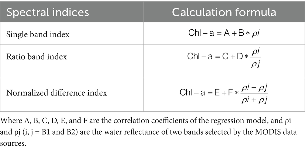
Table 1. Spectral indices for estimating Chl-a concentration.
2.4.1 Chl-a retrieval and assessment methods
To retrieve Chl-a concentrations, a linear regression model was developed using selected spectral features derived from MODIS-Terra data. Feature importance was assessed through Pearson correlation coefficients with in-situ Chl-a measurements. Between the tested variables, NIR reflectance shown the strongest correlation (R2 = 0.53), compared to NDVI (R2 = 0.46), the Simple Ratio (R2 = 0.42), and red reflectance (R2 = 0.23). The results show that NIR reflectance is the best informative predictor of Chl-a concentration in Lake Tana. The Chl-a concentration was retrieved through linear fitting based on the MODIS surface reflectance data and in situ measured Chl-a concentration data. Additionally, the root-mean-square error (RMSE), mean absolute error (MAE) and mean absolute percentage error (MAPE) were used to evaluate the accuracy of the Chl-a retrieval results (Equations 1–3).
There is no fixed RMSE threshold for Chl-a remote sensing accuracy; tolerable values depend on trophic status, use, and data variability. In the mesotrophic to eutrophic lakes like Lake Tana, RMSEs of 2–10 μg/L are mostly tolerable if they continue below 30% of the mean Chl-a concentration (Assegide et al., 2023; Makwinja et al., 2023; Shahvaran, 2024). This level of precision usually provisions consistent revealing of spatial and seasonal patterns. Conversely, further stringent precision (lower RMSE) may be essential for operational monitoring. The smaller the MAE value is, the closer the retrieval value is to the real value. The MAPE is the average absolute percentage error, where a MAPE value of 0% means a perfect model and a MAPE greater than 100% means an inferior model. The equations can be expressed according to (Cao et al., 2022a).
Where n represents the number of observed values, and Xi and Yi represent the retrieval value and true value of the Chl-a, respectively.
2.4.2 Calibration and validation of regression models
Following the methodology outlined by Álvarez Robles (2019), the predictive performance of the final regression model was evaluated using independent calibration and validation datasets. The dataset was randomly divided into two groups: 70% of the data was designated for calibration, to develop the linear regression model. The remaining 30% of the data served as the validation dataset, used to assess the accuracy of the regression coefficients derived from the calibration process.
2.5 Statistical methods
To assess trends in Chl-a, the non-parametric Mann–Kendall trend test (Kendall, 1948; Mann, 1945) was applied to determine whether a statistically significant trend existed in the time series data over the 2008–2018 period. The time series plot of Chl-a concentration for Lake Tana in August, December, and March, based on satellite image from 2008–2018, is presented. The Mann–Kendall nonparametric trend test analyzes the sign of the difference between later-year data and earlier-year data. The Mann–Kendall test examines whether there is a monotonic upward or downward trend in the dataset, meaning the values consistently increase or decrease over time. It works by evaluating the sign of differences between pairs of observations, comparing later data points to earlier ones. The number of positive differences versus negative differences determines the direction and strength of the trend. Normalized test statistics, Z are computed according to Douglas et al. (2000). The size of the statistical variable Z represents the change in the trend of the data. The significance level (α) is set to be 0.05, under which the Z1 − α/2 equals 1.96. When |Z| ≥ Z1 − α/2, the hypothesis is not accepted in a two-sided test. Flowingly, Z > 0 indicates a positive trend, while Z < 0 indicates a negative trend.
3 Results
3.1 Observed Chl-a concentrations
The Chl-a concentration was measured at 143 sampling locations across Lake Tana. The average Chl-a concentration increased markedly from 2.2 μg/L (ranging from 0.1 to 19.4 μg/L) in August 2016, to 13.6 μg/L (ranging from 0.1 to 148.2 μg/L) in December 2016, and reached a peak of 21.4 μg/L (ranged from 0.1 to 191.6 μg/L) in March 2017 (Table 2 and Supplementary Table S1). Both the mean and the range of Chl-a values show a distinct seasonal progression, with the lowest concentrations occurring during the rainy season (August) and the highest concentrations during the dry season (March).

Table 2. Descriptive statistics for the measured Chl-a concentrations of Lake Tana in μg/L.
Spatially, Chl-a concentrations in August exhibited two distinct zones, with minimum values in the western side and maximum values in the eastern side of Lake Tana (Figure 2a). In December, the highest concentrations appeared in the southeastern and northeastern regions, while the western part still had the lowest concentrations (Figure 2b). The lowest concentration in December extended to the majority of the northern part and limited areas in the east. Conversely, during the dry season in March, the spatial distribution changed completely, with the lowest concentrations in the south, northeast, northwest, and certain parts of the central lake, and the maximum concentrations in the north, east at the entrance of the Gumara River, and southwest at the entrance of the Gilgel Abay River (Figure 2c).

Figure 2. Measured Chl-a concentrations in μg/L of Lake Tana on: (a) August 2016; (b) December 2016, and (c) March 2017.
3.2 Correlation between estimated and measured Chl-a concentrations
Predicted Chl-a concentrations exhibited a clear seasonal trend, increasing substantial from August to March in alignment with the observed data. Specifically, predicted Chl-a values followed a parallel trajectory, starting at 2.86 μg/L in August, progressing to 15.35 μg/L in December, and reaching a maximum of 21.75 μg/L in March, as detailed in Tables 2, 3 and Supplementary Table S2. This upward trend indicates a maximum concentration during the dry season, suggesting a strong influence of seasonal factors on algal growth. The prediction accuracy evaluated with RMSE and MAE was within a reasonable range (Table 3).

Table 3. Descriptive statistics for the measured versus estimated Chl-a concentrations in μg/L.
A consistent linear relationship was identified between Chl-a concentrations and various combinations of red and near-infrared (NIR) bands derived from MODIS-Terra reflectance data. Notably, the NIR band exhibited the highest correlation, proving most effective for Chl-a retrieval across all sampling periods. Consequently, specific regression equations were developed for each sampling period. For August, the calibrated relationship between Chl-a and MODIS-Terra reflectance is represented by Equation 4, visually depicted in Figure 2. Similarly, Equations 5, 6 detail the calibrated regression relationships for December and March, respectively.
where Chl-a is expressed in μg/L, n is the number of samples, p indicates a statistically significant probability of the linear relationship (p < 0.001), and r2 represents the coefficient of determination, quantifying the goodness of fit for August (Table 3 and Figure 2), for December (Supplementary Table S3 and Supplementary Figure S1), and for March (Supplementary Table S4 and Supplementary Figure S2).
The correlation analysis confirmed a significant relationship between MODIS near-infrared (NIR) band reflectance and Chl-a concentration, though the strength of this correlation varied across different months, as evidenced by the fluctuating r2 values in Equations 4–6. Notably, the r2 values demonstrated that the MODIS NIR band effectively predicts Chl-a concentrations. Furthermore, Equations 5, 6, provide the model coefficients necessary to calculate Chl-a levels across the entire surface of Lake Tana, utilizing the pixel reflectance values from the satellite imagery. The statistical significance of these correlations was confirmed by p-values consistently below 0.05 (p < 0.05).
Figure 3 illustrates the relationship between MODIS spectral bands and Chl-a concentrations, revealing that the near-infrared (NIR) band as the most effective for Chl-a retrieval in Lake Tana. The scatter plot in Figure 3 and Supplementary Figures S1, S2 show a clear linear relationship between NIR band reflectance and Chl-a levels, confirming its suitability for accurate estimation. In contrast, the red band showed minimal correlation, suggesting it is not informative for water quality retrieval in this context. This finding underscores the importance of the NIR band in MODIS for detecting Chl-a. Furthermore, the MODIS-derived Chl-a estimates exhibited a statistically significant correlation (r2 = 0.53) with observed values, and a Root Mean Squared Error (RMSE), Mean Absolute Error (MAE), and Mean Absolute Percentage Error (MAPE) at a p-value less than 0.005. These results collectively demonstrate that MODIS, particularly utilizing the NIR band, can effectively detect and estimate Chl-a concentrations in these inland waters.

Figure 3. Scatter plot of observed Chl-a (μg/L) against Mod 09 Q1 surface reflectance bands in August 2016.
3.3 Predicted Ch-a distribution of Lake Tana
The predicted results revealed clear spatiotemporal variation in Chl-a concentration over Lake Tana across the observed months. The predicted Chl-a concentration averaged 2.86 μg/L in August 2016, with values ranging from 0 to 6.9 μg/L. In December 2016, the average increased to 15.35 μg/L, with values ranging from 0 to 157.4 μg/L. Through March 2017, Chl-a reached an average of 21.75 μg/L, ranging from 0 to 58.6 μg/L (Table 4 and Supplementary Table S2).

Table 4. Estimation statistics for various band combinations; bold numbers indicate the highest R2 value in August 2016.
Figure 4 illustrates a consistent spatially increasing trend in Chl-a concentrations from August to March. In August, the lowest values were observed in the western part of Lake Tana, with higher concentrations in the east (Figure 4a). In December, the highest levels were recorded at the entrance of the main rivers (Figure 4b). In March, Chl-a concentrations were generally elevated throughout the lake.

Figure 4. Retrieval of the Chl-a concentrations in Lake Tana on: (a) August 2016; (b) December 2016 and (c) March 2017.
3.4 Generating Chl-a time series data for Lake Tana
Using the developed regression equations, the Chl-a concentrations were retrieved over a 10 year period (2008–2018). The spatial distribution of Chl-a concentrations was then mapped to visualize the spatial variations of each year for the predicted months (Supplementary Figures S3–S5). Retrieved Chl-a concentration in the lake for August, December and March showed an increasing trend from the 2008 to 2018 periods (Figure 5). As the computed p-value is lower than the significance level alpha (0.05), the null hypothesis was rejected, and the alternative hypothesis was accepted in favor of the increasing trend in the series, particularly during the dry seasons.

Figure 5. Estimated Chl-a time series (2008–2018) for Lake Tana, derived from the developed models.
From the 10-year period, the R2 values from the linear trend analyses indicate a weak to moderate link among the variables used for the estimation of Chl-a concentrations. The R2 values of 0.43, 0.44, and 0.25 propose that the linear models described simply 25 to 44% of the variation in Chl-a over period. This indicates that, while some temporal trends have existed, a substantial portion of the variability residues unexplained, probably caused by the effect of other environmental or anthropogenic factors not captured by the linear models.
4 Discussion
4.1 Spatiotemporal Chl-a patterns
This study utilized MODIS/Terra Surface Reflectance 8-Day L3 data to estimate Chl-a concentrations in Lake Tana, which is seriously infested with water hyacinth. Chl-a concentrations resulting from satellite data were validated using in situ samples collected from 143 locations. A linear regression model applied to the red and near-infrared bands, with a spatial resolution of 250 m, achieved an R2 of 0.53, RMSE of 2.76 μg/L, MAE of 0.42 μg/L, and MAPE of 12.5%. These metrics suggest that the model captures a significant portion of the spatial variability in Chl-a of the lake.
While the accuracy of MODIS-based models varied widely depending on the waterbody type, optical complexity, resolution of imagery, and choice of algorithm (Table 5), the performance of this study aligns with findings in turbid large shallow lakes. For example, Gidudu et al. (2021) showed R2 values of up to 0.80 and RMSE around 5 μg/L in Lake Victoria, the largest African lake, using empirical models with MODIS data, Oliveira Santos et al. (2024) indicated that MODIS 500 m products yield R2 values between 0.6 and 0.75 for Chl-a in Brazilian reservoirs, with RMSE values from 2 to 4 μg/L, which is comparable with this study’s results. In contrast, advanced performance was also noted in studies, for example, Feng et al. (2018) and Zhang et al. (2016) where R2 exceeded 0.85 and RMSE was below 0.4 μg/L; However, these studies often targeted less turbid waterbodies.

Table 5. Comparative summary of error metrics from studies using MODIS data for Chl-a estimation in inland and coastal waters.
The viability and accuracy of regression models for Chl-a estimation are often season-dependent, as the optical properties of water bodies vary throughout the year. For example, Kallio et al. (2001) confirmed that model coefficients derived for May differ noticeably from those for August, reflecting seasonal variations in water composition and light conditions. Similarly, Chl-a coefficients for August vary from those obtained in December and March (Figure 4). In Lake Tana, the spectral signal of Chl-a is weak in areas with high suspended materials, particularly during the rainy and post-rainy seasons (Ayele and Atlabachew, 2021). The Lake’s surface extent and optical properties also fluctuate seasonally, influenced by rainfall and sediment load (Kebedew et al., 2021; Seong et al., 2017). Similar seasonal Chl-a variabilities have been observed in other African lakes, including Rift Valley lakes (Dagne et al., 2023) and Lake Naivasha (Ndungu et al., 2013). These results highlight the important of seasonal drivers in determining and controlling Chl-a dynamics.
Emerging research continues to emphasize the impact of seasonal variations on Chl-a estimation. For instance, Cao et al. (2022b) observed that Chl-a concentrations in small lakes were higher in summer and autumn compared to spring and winter, with air temperature positively correlating with seasonal mean Chl-a across various lake sizes. Similarly, Ngamile et al. (2025) found that Chl-a concentrations strongly absorbed light in the blue (490 nm) and red (665 nm) wavelengths, while reflecting light in the green (560 nm) and near-infrared (842 nm) wavelengths, with significant seasonal variations in these spectral characteristics. Studies leveraging MODIS data have significantly advanced our understanding of seasonal variability in Chl-a concentrations across various aquatic systems (Devi and Sarangi, 2023; Harid et al., 2022; Harid et al., 2022; Sun et al., 2023; Ye et al., 2024).
The seasonal dynamics of Chl-a concentrations in Lake Tana are closely associated with climatic conditions, particularly during the dry season when increased sunshine hours and wind-induced resuspension of nutrients encourage higher rates of water hyacinth growth (Kebedew et al., 2021). As underlined by Moges et al. (2017), Chl-a tends to increase during the dry period due to enhanced solar radiation. Our findings also revealed a consistent increase in Chl-a concentrations from August to March (Figure 5), a pattern commonly attributed to water hyacinth blooms encouraged by prolonged sunlight exposure. This seasonal blooming is further facilitated by the resuspension of particulate nutrients from the lake bed, mainly driven by wind-induced mixing, as noted by Kebedew et al. (2021).
Besides natural drivers, anthropogenic activities significantly influence Chl-a concentrations. Lake Tana is a vulnerable water body, runoff from adjacent farmlands, especially during the dry season, introduces fertilizer-derived nutrients into the lake, promoting eutrophication (Alemu et al., 2017). Similar eutrophication-driven patterns have been reported in Lake Chamo (Admas et al., 2020) and Lake Chad (Buma and Lee, 2020). Recent studies, such as Nerae et al. (2024), confirm that nutrient-rich runoff continues to be a major contributor to water hyacinth and algal growth in Lake Tana, posing a significant threat to the ecological and human health of communities dependent on the lake (Nerae et al., 2024b). In comparison to other findings in the lake, Moges et al. (2017) used Landsat 7 ETM + and non-linear regression to estimate Chl-a, reporting an average value of 3.76 μg/L in December, which is lower than our current findings using MODIS 8-Day L3. This variation may be due to differences in satellite resolution, the spectral range of sensors, or seasonal variability in nutrient dynamics. Additionally, current literature highlights the growing effectiveness of MODIS based methods for Chl-a retrieval. For instance, Zhang et al. (2024) confirmed that MODIS temporal granularity enables better alignment with in-situ observations, particularly under conditions of variable cloud cover. Also, studies by Devi and Sarangi (2023) and Deng et al. (2017) have revealed the reliability of MODIS data in tracking phytoplankton dynamics in tropical and subtropical freshwater systems. These results and Table 5 confirm the utility of MODIS 250 m imagery for consistent, cost-effective, and large-scale monitoring of water quality parameters such as Chl-a, particularly in dynamic freshwater systems like Lake Tana, where seasonal and anthropogenic influences interrelate.
Temporally, the Chl-a concentration predicted by the linear regression model for 2016 exhibited notable seasonal variability. The maximum predicted concentration reached 157.4 μg/L in December, while the minimum was 0 μg/L in August (Figure 4). This wide range of predicted values exceeded the observed in situ measurements (Table 2), showing that the model overestimated peak Chl-a levels by approximately 9.2 μg/L in December, and underestimated lower extremes in August and March, where observed values were 0.05 μg/L and 133 μg/L, respectively. These inconsistencies highlight the models’s limitations in capturing nonlinear dynamics and extreme fluctuations commonly seen in complex inland waters (Gidudu et al., 2021).
This pattern aligns with findings by Mucheye et al. (2022), who used Sentinel imagery to estimate Chl-a in Lake Tana and reported a maximum value of 40 μg/L by the end of August, with a minimum of 4.4 μg/L in June. Their study emphasizes that the peak Chl-a concentration tends to occur during the post-rainy season, rather than during peak rainfall months, likely due to nutrient influx from catchment runoff. Similarly, Wondie et al. (2007) observed that the highest spatial coverage of Chl-a also occurred after the rainy season, rather than during it, further emphasizing the delayed response of phytoplankton growth to nutrient input.
Comparatively, models using Landsat 7 ETM + satellite data have also shown seasonal performance variability. Moges et al. (2017) found that the model underperformed during transitional months like November and May, with R2 values of just 0.28 and 0.1, respectively. Regardless of these model performance issues, the average Chl-a concentration predicted by the MODIS based regression model in our study remained comparable to the in situ observed mean (Table 2), suggesting that while extreme values are poorly captured, the model is reasonably effective for estimating average concentrations. Despite that, recent literature further supports the need for seasonally adaptive or non-linear models to improve accuracy in predicting Chl-a in dynamic lakes (Zhang et al., 2024; Deng et al., 2024).
Another latest finding by Nerae et al. (2024) in Lake Tana revealed that the lowest concentration of Chl-a was observed in the rainy season due to reduced algal blooms from increased rainfall, wind waves, diminished light, and higher dilution caused by new runoff (Nerae et al., 2024; Kebedew et al., 2023). The highest levels of Chl-a were found in the post-rainy and dry seasons and were attributed to ample light, stagnant water, biochemical changes, and enhanced water hyacinth growth. Therefore, our predictions of Chl-a concentration appear to be more accurate than those who predicted the highest Chl-a coverage during the rainy period (Mucheye et al., 2022). Similar to the current study, recent research showed that the Rib and Gumara inlets (eastern parts) and Gilgel Abay River (western parts) of the lake have higher nutrient influxes and amplify Chl-a levels (Kebedew et al., 2023; Nerae et al., 2024). This is attributed to wind-driven circulation patterns in the lake, which result in extended residence times for pollutants entering through different inlets (Kebedew et al., 2023). Most of the previous studies on Lake Tana indicated that the lake water quality was impaired (Melaku et al., 2020; Tibebe et al., 2019). According to Nerae et al. (2024) Lake Tana is identified to be in a middle-eutrophic to hypereutrophic state, with considerable nutrient fluxes contributing to water hyacinth blooms, which further cause degraded water quality (Nerae et al., 2024). Thus, this study shows that Chl-a concentrations in Lake Tana are very high, confirming that the lake is Eutrophic, complementing the Nerae et al. (2024) study.
When comparing the Chl-a levels in Lake Tana with other African lakes, we found that Chl-a concentration measured from the two largest Ethiopian Rift Valley lakes in Ethiopia, Lake Abaya and Lake Chamo, between 2016 and 2019 ranged from 17.0 ± 3.6 μg/L in Lake Abaya to 33.0 ± 11.6 μg/L in Lake Chamo (Dagne et al., 2023) is lower with this study which ranges from 2.24 to 21.75 μg/L. A similar study in Victoria Lake using in situ Chl-a and MODIS satellite images showed poor performance (R2 = 0.03) compared to our study (R2 = 0.53) (Gidudu et al., 2021). In the case of Lake Malawi, Chl-a concentration estimations from MODIS surface reflectance were very low, ranging from 0.05 μg/L to 0.27 μg/L, with a mean value was 1.0 μg/L, verifying that the lake was oligotrophic during this time (Chavula et al., 2009). In Lake Naivasha, Kenya, using MODIS surface reflectance, the maximum and minimum values of Chl-a concentration varied from 0 μg/L in January to 40 μg/L in December. According to Ndungu et al. (2013), MODIS satellite data tend to underestimate Chl-a concentrations compared to in-situ measurements. However, in this study, both under and overestimation occurred. Similar variability has been noted in other regions. For instance, Han and Jordan (2005) reported Chl-a concentrations ranging from 0.93 to 24.92 μg/L in Pensacola Bay using Landsat ETM+, while Rani et al. (2019) found values between 3.22 and 3.41 μg/L in Ghana’s Densu River using Landsat-8. However, Chl-a concentrations in Lake Tana were higher than the above-stated lakes and rivers compared with the maximum value.
Elevated Chl-a levels in Lake Tana can likely be attributed to increased nutrient inputs resulting from expanding agricultural activities within the lake’s catchment (Worqlul et al., 2020; Alemu et al., 2017), a pattern similarly observed in other Ethiopian lakes. For example, Lake Chamo showed Chl-a concentrations of 19.64 to 33.28 μg/L largely due to runoff from agricultural fertilizers and resident wastewater (Admas et al., 2020; Goshu and Aynalem, 2017; Tesfaye, 2023; Wondie, 2009). Likewise, Lake Ardibo exhibited a strong periodic discrepancy influenced by ecological drivers (Mohammed et al., 2023). Studies from external Ethiopia as well support this pattern: eutrophic conditions allied to land use were detected in Lake Qilu, China (Li et al., 2022), and high Chl-a variability was recognized in Lake Chad (Buma and Lee, 2020) and Hulun Lake (Zhang et al., 2024). These results highlight the significance of land use practices, nutrient loading, and hydrological dynamics in inducing Chl-a variability through various freshwater systems.
Overall, Lake Tana suffered major water quality changes over time (Nerae et al., 2024; Dersseh et al., 2022). Accurate predictions help decision-makers understand the full extent of water quality degradation in the lake. For example, since 2003, the average spatial Chl-a concentration has increased from 4.8 μg/L to 32.7 μg/L in 2020 (Wondie et al., 2007). Thus, there has been an eightfold increase in Chl-a within just two decades. Our study confirms Nerae et al. (2024) and Dersseh et al. (2022) by demonstrating a decline in Lake Tana’s water quality, shifting from slightly polluted to polluted, driven by eutrophication, evidenced by water hyacinth proliferation, and attributed to nutrient enrichment, oxygen depletion, and elevated suspended solids, with significant impacts observed in the lake (Kebedew et al., 2021). Given Lake Tana’s role as a headwater of the Blue Nile, its degradation poses downstream risks to the Upper Nile Basin (Kebedew et al., 2023; Worqlul et al., 2020). Reducing lake nutrient inputs, alongside coordinated water hyacinth control-will be essential for enhancing ecological resilience and fostering transboundary cooperation (Gidudu et al., 2021; Zhang et al., 2024; Buma and Lee, 2020; Chavula et al., 2009; Li et al., 2022).
For future research, it is necessary to develop a refined algorithm with some additional in situ measurements and expand the study to assess the impact of various best management practices of the lake watershed on water quality. While this study does not exhaustively explore all empirical formula models, the relationship established with remote sensing variables would provide insight into the factors affecting the Chl-a variable. In general, the linear regression model developed can be applied as a tool to reduce costs and efforts in fieldwork measures and to understand eutrophication in this lake transition ecosystem.
4.2 Implications for the evolution of water hyacinths and eutrophication
Several reports have been published regarding the external nutrient loads and water quality status of Lake Tana (Alemu et al., 2020; Ewnetu et al., 2014; Tibebe et al., 2019), ecological condition and the coverage of water hyacinth (Kibret et al., 2019; Wondie, 2018), algal bloom and trophic status of the lake (Moges et al., 2017; Tibebe et al., 2019; Wondie, 2018), and pollution and eutrophication level (Nerae et al., 2024). The Chl-a results found in the current assessment are linked to the surface water quality and eutrophication status of the lake, indicated by different authors including (Alemu et al., 2020; Ayele and Atlabachew, 2021; Melesse et al., 2019; Nerae et al., 2024). The main factors influencing the growth and spread of water hyacinth include total nitrogen, phosphorus levels, pH, surface water temperature, salinity, and water depth (Gaikwad and Gavande, 2017). According to previous studies (Alemu et al., 2020; Ayele and Atlabachew, 2021; Melesse et al., 2019), the north and northeastern parts of Lake Tana are highly susceptible to water hyacinth invasion, which aligns with the current Chl-a spatial pattern. Moreover, the studies indicate that shallower areas of the lake tend to have a higher presence of water hyacinth, which is closely linked to the current levels of higher Chl-a concentrations at those shoreline regions. Collectively, these papers have highlighted a decline in water quality, an increase in water hyacinth, and eutrophication over time. These changes may be related to non-point source pollution, sediment and nutrient inflows, and elevated erosion rates from the watershed, particularly due to agricultural activities (Alemu et al., 2020; Moges et al., 2017).
Nutrient inflows, particularly phosphorus concentrations, are the most significant factors contributing to the growth of water hyacinths in Lake Tana (Dersseh et al., 2019a; Worqlul et al., 2020). The accumulation of sediment and phosphorus from the northern and eastern catchments of Lake Tana is a primary contributor to the high levels of suspended sediment and the reduced visibility measured by the Secchi disk (Kebedew et al., 2023). In the northern and eastern regions of Lake Tana, increased phosphorus concentrations and turbidity lead to reduced light transparency and shorter Secchi disk readings. This phenomenon is directly related to elevated Chl-a concentrations and the process of eutrophication (Nerae et al., 2024). These effects are most pronounced during dry seasons, when water levels decline, facilitating water hyacinth proliferation (Dersseh et al., 2019a, 2019b; Kebedew et al., 2021; Kebedew et al., 2020). Given the significant accumulation of phosphorus in the sediment, managing and curbing the spread of water hyacinths in Lake Tana is likely to be a lengthy and complex process (Admas et al., 2020). Since phosphorus cycles from the bottom sediment to the water hyacinths, which accumulate in their biomass (Kebedew et al., 2023). Harvesting these plants could help lower the phosphorus concentration in the sediment.
In addition, the trophic status of Lake Tana has been evaluated at various times (Moges et al., 2017; Nerae et al., 2024; Tibebe et al., 2019) using the Carlson Trophic State Index to assess the lake’s condition. Their findings indicated that Lake Tana’s trophic state falls between mesotrophic and hypereutrophic. Furthermore, they noted that Chl-a concentration was directly linked to the level of eutrophication, with higher Chl-a levels found in the shoreline areas of Lake Tana, especially during the dry monsoon season, where the trophic status was elevated. The external loading of nutrients and agrochemicals from the watershed surrounding the lake, primarily through the four major rivers during the wet season, is considered a key factor exacerbating Chl-a levels and eutrophication in the lake. To improve the current algal biomass in terms of Chl-a and trophic status, it is recommended to implement wetland management, reduce recession agriculture, manage agrochemical use in the watershed, and establish buffer zones around the lake.
4.3 Limitations and recommendations
This study provides valuable insights into Chl-a dynamics and water hyacinth proliferation in Lake Tana; however, several limitations should be considered. The MODIS-based regression model showed reduced accuracy during transitional months and struggled to capture extreme Chl-a values, reflecting its limited sensitivity to seasonal variability (Gidudu et al., 2021; Moges et al., 2017). MODIS surface reflectance data may underestimate or overestimate Chl-a concentrations depending on water turbidity, cloud cover, and atmospheric conditions (Han and Jordan, 2005; Han et al., 2022; Ndungu et al., 2013). The use of a linear model may not fully capture nonlinear ecological responses, suggesting the need for seasonally adaptive or machine learning-based approaches (Zhang et al., 2024). Field sampling was constrained by logistical factors such as limited boat access, time, and budget, which may affect spatial representativeness (Moges et al., 2017; Worqlul et al., 2020). These limitations should be considered when applying the model to broader water quality assessments or management strategies. For future studies, using models that account for seasonal changes or applying machine learning approaches could improve predictions of Chl-a variability. Expanding field sampling and incorporating higher-resolution satellite data would also help capture the spatial and temporal patterns more accurately. In addition, managing the watershed through controlling nutrient runoff, restoring wetlands, and establishing buffer zones can reduce eutrophication and limit the spread of water hyacinth. Together, these steps would provide a clearer understanding of Chl-a dynamics and support effective water quality management in Lake Tana and similar freshwater systems.
5 Conclusion
Eutrophication, often signaled by elevated Chl-a levels due to excess nutrients, is challenging to assess in large lakes using traditional methods. Remote sensing offers a promising alternative solution. In this study, MODIS-Terra daily remotely sensed Chl-a concentrations were validated against 143 observed measurements collected from a large shallow lake, Lake Tana, characterized by water hyacinth infestation. Results showed that the NIR band based on the MODIS image presented the best performance for estimating Chl-a in the lake. The variation of Chl-a concentration over the lake was associated with the seasonal variation of the regional climate. Chl-a concentration is greatest in the dry season and is lower in the rainy season. A strong statistical relationship was observed between Chl-a concentration and MODIS-Terra daily reflectance over Lake Tana. The linear regression model was used to estimate the Chl-a concentration time series for 10 years, and it was found that the highest concentration of Chl-a has an increasing trend, deteriorating the water quality of Lake Tana. The reasonable agreement between MODIS and in situ Chl-a data, together with favorable results from the linear regression model, reveals the applicability and necessity of further studies on estimating Chl-a, from satellite imagery in the area. The spatial patterns of Chl-a concentrations in Lake Tana’s coastal areas were higher than in the pelagic areas, likely due to higher nutrient and pollutant inputs from agricultural activities of the surrounding and upstream areas. Seasonally, the lowest concentration of Chl-a was observed in the rainy monsoon, associated with reduced wind waves, algal blooms, increased rainfall, diminished light, and higher dilution caused by new runoff. The highest levels of Chl-a were recorded during the dry monsoon period, when increased temperature, ample light, stagnant water, and biochemical changes promote phytoplankton growth. The research establishes a foundation for directly aiding researchers in their ongoing fight to eradicate water hyacinths from Lake Tana, Ethiopia, and other similar African lakes. Continued refinement of remote sensing models and incorporation of additional ecological variables will further enhance water quality monitoring and promote sustainable lake management practices. Furthermore, the study underscores the need for basin-wide management strategies that not only consider the ecological health of the lake but also actively coordinate with and support local initiatives, ensuring that community-level practices align with broader conservation and water quality goals.
Data availability statement
The original contributions presented in the study are included in the article/Supplementary material, further inquiries can be directed to the corresponding author/s.
Author contributions
BA: Conceptualization, Data curation, Formal analysis, Writing – original draft. MK: Resources, Writing – review & editing. MN: Writing – review & editing. ST: Resources, Writing – review & editing. FZ: Conceptualization, Methodology, Supervision, Writing – review & editing.
Funding
The author(s) declare that no financial support was received for the research and/or publication of this article.
Conflict of interest
The authors declare that the research was conducted in the absence of any commercial or financial relationships that could be construed as a potential conflict of interest.
Generative AI statement
The authors declare that no Gen AI was used in the creation of this manuscript.
Any alternative text (alt text) provided alongside figures in this article has been generated by Frontiers with the support of artificial intelligence and reasonable efforts have been made to ensure accuracy, including review by the authors wherever possible. If you identify any issues, please contact us.
Publisher’s note
All claims expressed in this article are solely those of the authors and do not necessarily represent those of their affiliated organizations, or those of the publisher, the editors and the reviewers. Any product that may be evaluated in this article, or claim that may be made by its manufacturer, is not guaranteed or endorsed by the publisher.
Supplementary material
The Supplementary material for this article can be found online at: https://www.frontiersin.org/articles/10.3389/frwa.2025.1600222/full#supplementary-material
References
Abbas, M. R., Melesse, A. M., Scinto, L. J., and Rehage, J. S. (2019). Satellite estimation of chlorophyll-a using MODIS sensor in shallow coastal water bodies: Validation and improvement. Water 11:1621. doi: 10.3390/w11081621
Adjovu, G. E., Stephen, H., James, D., and Ahmad, S. (2023). Overview of the application of remote sensing in effective monitoring of water quality parameters. Remote Sens 15:1938. doi: 10.3390/rs15071938
Admas, A., Sahile, S., Agidie, A., Menale, H., Gedefaw, T., and Teshome, M. (2020). Controlling water hyacinth infestation in Lake Tana using fungal pathogen from laboratory level upto pilot scale. bioRxiv :1140. doi: 10.1101/2020.01.14.901140
Alemu, M. L., Geset, M., Mosa, H. M., Zemale, F. A., Moges, M. A., Giri, S. K., et al. (2017). Spatial and temporal trends of recent dissolved phosphorus concentrations in Lake Tana and its four main tributaries. Land Degrad. Dev. 28, 1742–1751. doi: 10.1002/ldr.2705
Alemneh, L. Y., Aklog, D., Griensven, A. V., Goshu, G., Yalew, S., Abebe, W. B., et al. (2025). Remote sensing approaches for water hyacinth and water quality monitoring: Global trends, techniques, and applications. Water 17:2573. doi: 10.3390/w17172573
Alemu, M. L., Worqlul, A. W., Zimale, F. A., Tilahun, S. A., and Steenhuis, T. S. (2020). Water balance for a tropical Lake in the volcanic highlands: Lake Tana, Ethiopia. Water 12:2737. doi: 10.3390/w12102737
Andres, L., Boateng, K., Borja-Vega, C., and Thomas, E. (2018). A review of in-situ and remote sensing technologies to monitor water and sanitation interventions. Water 10:756. doi: 10.3390/w10060756
Anteneh, W., Tewabe, D., Assefa, A., Zeleke, A., Tenaw, B., and Wassie, Y. (2015). Water hyacinth coverage survey report on Lake Tana biosphere reserve. Techn Rep Series 2, 1–25.
APHA (1998). Standard Methods for the Examination of Water and Wastewater. 20th Edn. American Water Works Association, Water Environment Federation: American Public Health Association.
Assegide, E., Shiferaw, H., Tibebe, D., Peppa, M. V., Walsh, C. L., Alamirew, T., et al. (2023). Spatiotemporal dynamics of water quality indicators in Koka reservoir, Ethiopia. Remote Sens 15:1155. doi: 10.3390/rs15041155
Ayele, H. S., and Atlabachew, M. (2021). Review of characterization, factors, impacts, and solutions of Lake eutrophication: lesson for lake Tana, Ethiopia. Environ. Sci. Pollut. Res. 28, 14233–14252. doi: 10.1007/s11356-020-12081-4
Biru, M. K., Minale, A. S., and Debay, A. B. (2015). Multitemporal land use land cover change and dynamics of Blue Nile Basin by using GIS and remote sensing techniques, North-Western Ethiopia. Int. J. Environ. Sci. 4, 81–88.
Bishop-Taylor, R., Sagar, S., Lymburner, L., Alam, I., and Sixsmith, J. (2019). Sub-pixel waterline extraction: characterising accuracy and sensitivity to indices and spectra. Remote Sens 11:2984. doi: 10.3390/rs11242984
Bresciani, M., Stroppiana, D., Odermatt, D., Morabito, G., and Giardino, C. (2011). Assessing remotely sensed chlorophyll-a for the implementation of the Water Framework Directive in European perialpine lakes. Sci. Total Environ. 409, 3083–3091. doi: 10.1016/j.scitotenv.2011.05.001
Bukata, R. P. (2013). Retrospection and introspection on remote sensing of inland water quality:" like déjà vu all over again". J. Great Lakes Res. 39, 2–5. doi: 10.1016/j.jglr.2013.04.001
Buma, W. G., and Lee, S.-I. (2020). Evaluation of Sentinel-2 and Landsat 8 images for estimating Chlorophyll-a concentrations in Lake Chad, Africa. Remote Sens 12:2437. doi: 10.3390/rs12152437
Caballero, C. B., Guedes, H. A. S., Andrade, A. C. F., Martins, V. S., Fraga, R. S., and Mendes, K. G. (2022). Empirical and semi-empirical Chlorophyll-a modeling for water quality assessment through river-lake transition in extreme southern Brazil. An. Acad. Bras. Cienc. 94, 1–16. doi: 10.1590/0001-3765202220201891
Cao, Z., Ma, R., Melack, J. M., Duan, H., Liu, M., Kutser, T., et al. (2022a). Landsat observations of Chlorophyll-a variations in Lake Taihu from 1984 to 2019. Int. J. Appl. Earth Obs. Geoinf. 106:102642. doi: 10.1016/j.jag.2021.102642
Cao, Z., Shen, M., Kutser, T., Liu, M., Qi, T., Ma, J., et al. (2022b). What water color parameters could be mapped using MODIS land reflectance products: a global evaluation over coastal and inland waters. Earth-Sci. Rev. 232:104154. doi: 10.1016/j.earscirev.2022.104154
Chang, F., Hou, P., Wen, X., Duan, L., Zhang, Y., and Zhang, H. (2022). Seasonal stratification characteristics of vertical profiles and water quality of Lake Lugu in Southwest China. Water 14:2554. doi: 10.3390/w14162554
Chavula, G., Brezonik, P., Thenkabail, P., Johnson, T., and Bauer, M. (2009). Estimating chlorophyll concentration in Lake Malawi from MODIS satellite imagery. Physics and Chemistry of the Earth, Parts A/B/C 34, 755–760. doi: 10.1016/j.pce.2009.07.015
Chen, L., Liu, L., Liu, S., Shi, Z., and Shi, C. (2025). The application of remote sensing technology in inland water quality monitoring and water environment science: recent progress and perspectives. Remote Sens 17:667. doi: 10.3390/rs17040667
Dagne, A., Tadesse, H., and Teshome, K. (2023). Limnological features and water-quality changes of two Ethiopian Rift Valley lakes, Lake Abaya and Lake Chamo. Afr. J. Aquat. Sci. 48, 237–246. doi: 10.2989/16085914.2023.2218411
Danbara, T. T. (2014). Deriving water quality indicators of Lake Tana, Ethiopia, from Landsat-8. eds. M.H.D. Salama and T.H.M. Rientjes.Enschede, Netherlands. University of Twente. doi: 10.13140/RG.2.1.2998.7282
Deng, Y., Zhang, Y., Li, D., Shi, K., and Zhang, Y. (2017). Temporal and spatial dynamics of phytoplankton primary production in Lake Taihu derived from MODIS data. Remote Sens 9:195. doi: 10.3390/rs9030195
Deng, Y., Zhang, Y., Pan, D., Yang, S. X., and Gharabaghi, B. (2024). Review of recent advances in remote sensing and machine learning methods for lake water quality management. Remote Sens 16:4196. doi: 10.3390/rs16224196
Dersseh, M. G., Ateka, A., Zimale, F. A., Worqlul, A. W., Moges, M. A., Dagnew, D. C., et al. (2020). Dynamics of eutrophication and its linkage to water hyacinth on lake Tana, upper Blue Nile, Ethiopia: understanding land-lake interaction and process. eds. Habtu, N. G., Ayele, D. W. Fanta, S. W, Admasu, B. T. and Bitew, M. A. Springer. Advances of Science and Technology: 7th EAI International Conference, ICAST (2019). Bahir Dar, Ethiopia, August 2–4, 2019, Proceedings 7.
Dersseh, M. G., Kibret, A. A., Tilahun, S. A., Worqlul, A. W., Moges, M. A., Dagnew, D. C., et al. (2019a). Potential of water hyacinth infestation on lake Tana, Ethiopia: a prediction using a GIS-based multi-criteria technique. Water. Switzerland: Springer Nature, Cham, 11:1921. doi: 10.3390/w11091921
Dersseh, M. G., Melesse, A. M., Tilahun, S. A., Abate, M., and Dagnew, D. C. (2019b). “Water hyacinth: review of its impacts on hydrology and ecosystem services—lessons for management of Lake Tana” in Extreme hydrology and climate variability, 237–251.
Dersseh, M. G., Steenhuis, T. S., Kibret, A. A., Eneyew, B. M., Kebedew, M. G., Zimale, F. A., et al. (2022). Water quality characteristics of a water hyacinth infested tropical highland Lake: lake Tana, Ethiopia. Front. Water 4:774710. doi: 10.3389/frwa.2022.774710
Devi, K. N., and Sarangi, R. (2023). Monitoring of monthly scale chlorophyll concentration variability in the bay of Bengal and Arabian Sea using MODIS aqua satellite data. J. Geom. 17, 1–10. doi: 10.58825/jog.2023.17.1.77
Douglas, E., Vogel, R., and Kroll, C. (2000). Trends in floods and low flows in the United States: impact of spatial correlation. J. Hydrol. 240, 90–105. doi: 10.1016/S0022-1694(00)00336-X
Dube, T., Mutanga, O., Seutloali, K., Adelabu, S., and Shoko, C. (2015). Water quality monitoring in sub-Saharan African lakes: A review of remote sensing applications. Afr. J. Aquat. Sci. 40, 1–7. doi: 10.2989/16085914.2015.1014994
Ellis, E. A., Allen, G. H., Riggs, R. M., Gao, H., Li, Y., and Carey, C. C. (2024). Bridging the divide between inland water quantity and quality with satellite remote sensing: an interdisciplinary review. WIREs Water 11:e1725. doi: 10.1002/wat2.1725
Ewnetu, D. A., Bitew, B. D., and Chercos, D. H. (2014). Determination of surface water quality status and identifying potential pollution sources of Lake Tana: particular emphasis on the lake boundary of Bahirdar City, Amhara region, north West Ethiopia, 2013. J. Environ. Earth Sci. 4, 88–97.
Fan, W., Xu, Z., Dong, Q., Chen, W., and Cai, Y. (2023). Remote sensing-based spatiotemporal variation and driving factor assessment of Chlorophyll-a concentrations in China’s Pearl River estuary. Front. Mar. Sci. 10, 1–15. doi: 10.3389/fmars.2023.1226234
Feng, L., Hu, C., and Li, J. (2018). Can MODIS land reflectance products be used for estuarine and inland waters? Water Resour. Res. 54, 3583–3601. doi: 10.1029/2017WR021607
Gaikwad, R. P., and Gavande, S. (2017). Major factors contributing growth of water hyacinth in natural water bodies. Int. J. Eng. Res. 6, 304–306. doi: 10.5958/2319-6890.2017.00024.1
Gezie, A., Assefa, W. W., Getnet, B., Anteneh, W., Dejen, E., and Mereta, S. T. (2018). Potential impacts of water hyacinth invasion and management on water quality and human health in Lake Tana watershed, Northwest Ethiopia. Biol. Invasions 20, 2517–2534. doi: 10.1007/s10530-018-1717-0
Gholizadeh, M. H., Melesse, A. M., and Reddi, L. (2016). A comprehensive review on water quality parameters estimation using remote sensing techniques. Sensors 16:1298. doi: 10.3390/s16081298
Gidudu, A., Letaru, L., and Kulabako, R. N. (2021). Empirical modeling of chlorophyll a from MODIS satellite imagery for trophic status monitoring of Lake Victoria in East Africa. J. Great Lakes Res. 47, 1209–1218. doi: 10.1016/j.jglr.2021.05.005
Gitelson, A. A., Gurlin, D., Moses, W. J., and Yacobi, Y. Z. (2011). “Remote estimation of Chlorophyll-a concentration in inland, estuarine, and coastal waters”. In eds. Weng, Q. Advances in Environmental Remote Sensing. (Boca Raton, Florida: Taylor and Francis Group), 449–478.
Goshu, G., and Aynalem, S. (2017). Problem overview of the lake Tana basin. Social and ecological system dynamics: Characteristics, trends, and integration in the Lake Tana Basin, Ethiopia, Edited by Krystyna Stave, Goraw Goshu, and Shimelis Aynalem. 9–23.
Greb, S., Dekker, A. G., Binding, C., Bernard, S., Brockmann, C., DiGiacomo, P., et al. (2018). Earth observations in support of global water quality monitoring. Edited by Steven Greb, Arnold G. Dekker, and Chris Binding (IOCCG Report No. 17). Dartmouth, Nova Scotia, Canada: International Ocean-Colour Coordinating Group.
Gupana, R. S., Odermatt, D., Cesana, I., Giardino, C., Nedbal, L., and Damm, A. (2021). Remote sensing of sun-induced Chlorophyll-a fluorescence in inland and coastal waters: current state and future prospects. Remote Sens. Environ. 262:112482. doi: 10.1016/j.rse.2021.112482
Gurlin, D., Gitelson, A. A., and Moses, W. J. (2011). Remote estimation of chl-a concentration in turbid productive waters—return to a simple two-band NIR-red model? Remote Sens. Environ. 115, 3479–3490. doi: 10.1016/j.rse.2011.08.011
Hailesilassie, W. T., and Tegaye, T. A. (2019). Comparative assessment of the water quality deterioration of Ethiopian Rift Lakes: The case of Lakes Ziway and Hawassa. Environ. Earth Sci Res J. 6, 162–166. doi: 10.18280/eesrj.060403
Ha, N. T. T., Koike, K., and Nhuan, M. T. (2013). Improved accuracy of Chlorophyll-a concentration estimates from MODIS imagery using a two-band ratio algorithm and geostatistics: as applied to the monitoring of eutrophication processes over Tien Yen Bay (northern Vietnam). Remote Sens 6, 421–442. doi: 10.3390/rs6010421
Han, Z., Gu, X., Zuo, X., Bi, K., and Shi, S. (2022). Semi-empirical models for the bidirectional water-leaving radiance: an analysis of a turbid inland lake. Front. Environ. Sci. 9:818557. doi: 10.3389/fenvs.2021.818557
Han, L., and Jordan, K. J. (2005). Estimating and mapping Chlorophyll-a concentration in Pensacola bay, Florida using Landsat ETM+ data. Int. J. Remote Sens. 26, 5245–5254. doi: 10.1080/01431160500219182
Harid, R., Demarcq, H., and Houma, F. (2022). SeaSonal trend decompoSition of modiS chlorophyll biomaSS timeS SerieS in the algerian baSin. Geo-Eco-Marina 28, 41–47. doi: 10.5281/zenodo.7491440
Helder, D., Markham, B., Morfitt, R., Storey, J., Barsi, J., Gascon, F., et al. (2018). Observations and recommendations for the calibration of Landsat 8 OLI and sentinel 2 MSI for improved data interoperability. Remote Sens 10:1340. doi: 10.3390/rs10091340
Hilker, T., Lyapustin, A. I., Tucker, C. J., Sellers, P. J., Hall, F. G., and Wang, Y. (2012). Remote sensing of tropical ecosystems: atmospheric correction and cloud masking matter. Remote Sens. Environ. 127, 370–384. doi: 10.1016/j.rse.2012.08.035
Huang, C., Zou, J., Li, Y., Yang, H., Shi, K., Li, J., et al. (2014). Assessment of NIR-red algorithms for observation of Chlorophyll-a in highly turbid inland waters in China. ISPRS J. Photogramm. Remote Sens. 93, 29–39. doi: 10.1016/j.isprsjprs.2014.03.012
Ivanchuk, N., Kogut, P. I., and Martyniuk, P. (2023). Sentinel-2 and MODIS data fusion for generation of daily cloud-free images at the sentinel resolution level. COLINS. 3, 61–71.
Johansen, R. A., Reif, M. K., Saltus, C. L., and Pokrzywinski, K. L. (2022). A review of empirical algorithms for the detection and quantification of harmful algal blooms using satellite-borne remote sensing. Vicksburg, Mississippi, USA: U.S. Army Engineer Research and Development Center (ERDC). Internal Report.
Kaba, E., Philpot, W., and Steenhuis, T. (2014). Evaluating suitability of MODIS-Terra images for reproducing historic sediment concentrations in water bodies: Lake Tana, Ethiopia. Int. J. Appl. Earth Obs. Geoinf. 26, 286–297. doi: 10.1016/j.jag.2013.08.001
Kallio, K., Pulliainen, J., Eloheimo, K., Koponen, S., Servomaa, H., Hannonen, T., et al. (2001). Semi-operative approach to lake water quality retrieval from remote sensing data. Sci. Total Environ. 268, 79–93. doi: 10.1016/S0048-9697(00)00687-2
Kebede, S., Travi, Y., Alemayehu, T., and Marc, V. (2006). Water balance of Lake Tana and its sensitivity to fluctuations in rainfall, Blue Nile basin, Ethiopia. J. Hydrol. 316, 233–247. doi: 10.1016/j.jhydrol.2005.05.011
Kebedew, M. G., Tilahun, S. A., Belete, M. A., Zimale, F. A., and Steenhuis, T. S. (2021). Sediment deposition (1940–2017) in a historically pristine lake in a rapidly developing tropical highland region in Ethiopia. Earth Surf. Process. Landforms 46, 1521–1535. doi: 10.1002/esp.5118
Kebedew, M. G., Tilahun, S. A., Zimale, F. A., Belete, M. A., and Steenhuis, T. S. (2020). The relationship of Lake morphometry and phosphorus dynamics of a tropical Highland Lake: Lake Tana, Ethiopia. Water 12.8:2243. doi: 10.3390/w12082243
Kebedew, M. G., Tilahun, S. A., Zimale, F. A., Belete, M. A., Wosenie, M. D., and Steenhuis, T. S. (2023). Relating Lake circulation patterns to sediment, nutrient, and water hyacinth distribution in a shallow tropical highland Lake. Hydrology 10:181. doi: 10.3390/hydrology10090181
Kendall, M. G. (1948). Rank correlation methods. Oxford, England: Griffin 20020405 (APA PsycInfo) Internal report.
Kganyago, M., Ovakoglou, G., Mhangara, P., Adjorlolo, C., Alexandridis, T., Laneve, G., et al. (2023). Evaluating the contribution of Sentinel-2 view and illumination geometry to the accuracy of retrieving essential crop parameters. GIScience Remote Sens. 60:2163046. doi: 10.1080/15481603.2022.2163046
Kolluru, S., and Tiwari, S. P. (2022). Modeling Ocean surface Chlorophyll-a concentration from ocean color remote sensing reflectance in global waters using machine learning. Sci. Total Environ. 844:157191. doi: 10.1016/j.scitotenv.2022.157191
Le, C., Hu, C., Cannizzaro, J., English, D., Muller-Karger, F., and Lee, Z. (2013). Evaluation of Chlorophyll-a remote sensing algorithms for an optically complex estuary. Remote Sens. Environ. 129, 75–89. doi: 10.1016/j.rse.2012.11.001
Leggesse, E. S., Zimale, F. A., Sultan, D., Enku, T., Srinivasan, R., and Tilahun, S. A. (2023). Predicting optical water quality indicators from remote sensing using machine learning algorithms in tropical highlands of Ethiopia. Hydrology 10:110. doi: 10.3390/hydrology10050110
Leiger, K., Linnanto, J. M., and Freiberg, A. (2020). Establishment of the Q y absorption Spectrum of chlorophyll a extending to near-infrared. Molecules 25:3796. doi: 10.3390/molecules25173796
Leinenkugel, P., Kuenzer, C., and Dech, S. (2013). Comparison and enhancement of MODIS cloud mask products for Southeast Asia. Int. J. Remote Sens. 34, 2730–2748. doi: 10.1080/01431161.2012.750037
Lencha, S. M., Tränckner, J., and Dananto, M. (2021). Assessing the water quality of Lake Hawassa, Ethiopia, Trophic state and suitability for anthropogenic uses, Applying common water quality indices. Int. J. Environ. Res. Public Health. 18:8904. doi: 10.3390/ijerph18178904
Li, D., Chang, F., Wen, X., Duan, L., and Zhang, H. (2022). Seasonal variations in water quality and algal blooming in hypereutrophic Lake Qilu of southwestern China. Water 14:2611. doi: 10.3390/w14172611
Li, H., Wan, W., Fang, Y., Zhu, S., Chen, X., Liu, B., et al. (2019). A Google earth engine-enabled software for efficiently generating high-quality user-ready Landsat mosaic images. Environ. Model. Softw. 112, 16–22. doi: 10.1016/j.envsoft.2018.11.004
Li, F., Yigitcanlar, T., Nepal, M., Nguyen, K., and Dur, F. (2023). Machine learning and remote sensing integration for leveraging urban sustainability: a review and framework. Sustain. Cities Soc. 96:104653. doi: 10.1016/j.scs.2023.104653
Liu, D., Chen, C., Gong, J., and Fu, D. (2010). Remote sensing of chlorophyll-a concentrations of the Pearl River Estuary from MODIS land bands. Int. J. Remote Sens. 31, 4625–4633. doi: 10.1080/01431161.2010.485148
Livanou, E., Sauzède, R., Psarra, S., Mandalakis, M., Dall’Olmo, G., Brewin, R. J., et al. (2024). Evaluating MULTIOBS Chlorophyll-a with ground-truth observations in the eastern Mediterranean Sea. Remote Sens 16:4705. doi: 10.3390/rs16244705
Makwinja, R., Inagaki, Y., Sagawa, T., Obubu, J. P., Habineza, E., and Haaziyu, W. (2023). Monitoring trophic status using in situ data and Sentinel-2 MSI algorithm: lesson from Lake Malombe, Malawi. Environmental Science Pollution Research 30, 29755–29772. doi: 10.1007/s11356-022-24288-8
Mann, H. B. (1945). Nonparametric tests against trend. Econometrica 13, 245–259. doi: 10.2307/1907187
Markogianni, V., Kalivas, D., Petropoulos, G. P., and Dimitriou, E. (2018). An appraisal of the potential of Landsat 8 in estimating Chlorophyll-a, ammonium concentrations and other water quality indicators. Remote Sens 10:1018. doi: 10.3390/rs10071018
McCartney, M., Alemayehu, T., Shiferaw, A., and Awulachew, S. (2010). Evaluation of current and future water resources development in the Lake Tana Basin, Ethiopia. Research Report No. 134, International Water Management Institute (IWMI), Colombo, Sri Lanka. 134, 1–74. doi: 10.3910/2010.204
McCullough, I. M., Loftin, C. S., and Sader, S. A. (2012). High-frequency remote monitoring of large lakes with MODIS 500 m imagery. Remote Sens. Environ. 124, 234–241. doi: 10.1016/j.rse.2012.05.018
Melaku, A., Yalew, A., Hailu, B., and Yitayew, T. (2020). Current trophic status of Lake Tana. Livestock Research Results: Ethiopia, 522.
Melchiorre, A., Boschetti, L., and Roy, D. P. (2020). Global evaluation of the suitability of MODIS-Terra detected cloud cover as a proxy for Landsat 7 cloud conditions. Remote Sens 12:202. doi: 10.3390/rs12020202
Miller, R. L., and McKee, B. A. (2004). Using MODIS terra 250 m imagery to map concentrations of total suspended matter in coastal waters. Remote Sens. Environ. 93, 259–266. doi: 10.1016/j.rse.2004.07.012
Moges, M. A., Schmitter, P., Tilahun, S. A., Ayana, E. K., Ketema, A. A., Nigussie, T. E., et al. (2017). Water quality assessment by measuring and using landsat 7 ETM+ images for the current and previous trend perspective: lake Tana Ethiopia. J. Water Resour. Prot. 9:1564. doi: 10.4236/jwarp.2017.912099
Mohammed, A., Mengistou, S., and Fetahi, T. (2023). The effects of water quality parameters, water level changes, and mixing on zooplankton community dynamics in a tropical high-mountain Lake Ardibo, Ethiopia. Environ. Monit. Assess. 195:927. doi: 10.1007/s10661-023-11500-6
Mohebzadeh, H., Mokari, E., Daggupati, P., and Biswas, A. (2021). A machine learning approach for spatiotemporal imputation of MODIS Chlorophyll-a. Int. J. Remote Sens. 42, 7381–7404. doi: 10.1080/01431161.2021.1957513
Mpakairi, K. S., Muthivhi, F. F., Dondofema, F., Munyai, L. F., and Dalu, T. (2024). Chlorophyll-a unveiled: Unlocking reservoir insights through remote sensing in a subtropical reservoir. Environ. Monit. Assess. 196:401. doi: 10.1007/s10661-024-12554-w
Mucheye, T., Haro, S., Papaspyrou, S., and Caballero, I. (2022). Water quality and water hyacinth monitoring with the sentinel-2A/B satellites in Lake Tana (Ethiopia). Remote Sens 14:4921. doi: 10.3390/rs14194921
Ndungu, J., Monger, B. C., Augustijn, D. C., Hulscher, S. J., Kitaka, N., and Mathooko, J. M. (2013). Evaluation of spatio-temporal variations in Chlorophyll-a in Lake Naivasha, Kenya: remote-sensing approach. Int. J. Remote Sens. 34, 8142–8155. doi: 10.1080/01431161.2013.833359
Nerae, M. D., Kebedew, M. G., Abebe, B. A., Moges, M. A., Zimale, F. A., Asres, B. W., et al. (2024). Assessment of pollution and trophic state of a water hyacinth infested tropical highland Lake: lake Tana in Ethiopia. Sustainable Water Resources Management 10, 1–15. doi: 10.1007/s40899-024-01152-w
Ngamile, S., Madonsela, S., and Kganyago, M. (2025). Trends in remote sensing of water quality parameters in inland water bodies: a systematic review. Front. Environ. Sci. 13:1549301. doi: 10.3389/fenvs.2025.1549301
Odermatt, D., Gitelson, A., Brando, V. E., and Schaepman, M. (2012). Review of constituent retrieval in optically deep and complex waters from satellite imagery. Remote Sens. Environ. 118, 116–126. doi: 10.1016/j.rse.2011.11.013
Oliveira Santos, V., Guimarães, B. M. D. M., Neto, I. E. L., de Souza Filho, F. d. A., Costa Rocha, P. A., Thé, J. V. G., et al. (2024). Chlorophyll-a estimation in 149 tropical semi-arid reservoirs using remote sensing data and six machine learning methods. Remote Sens 16:1870. doi: 10.3390/rs16111870
Ozbay, G., Fan, C., and Yang, Z. (2017). “Relationship between land use and water quality and its assessment using hyperspectral remote sensing in mid-Atlantic estuaries” in Water quality. (London, United Kingdom: IntechOpen). doi: 10.5772/66620
Pahlevan, N., Chittimalli, S. K., Balasubramanian, S. V., and Vellucci, V. (2019). Sentinel-2/Landsat-8 product consistency and implications for monitoring aquatic systems. Remote Sens. Environ. 220, 19–29. doi: 10.1016/j.rse.2018.10.027
Palmer, S. C., Kutser, T., and Hunter, P. D. (2015). “Remote sensing of inland waters: challenges, progress and future directions” in In, vol. 157. (Amsterdam, Netherlands: Elsevier), 1–8. doi: 10.1016/j.rse.2014.09.021
Papenfus, M., Schaeffer, B., Pollard, A. I., and Loftin, K. (2020). Exploring the potential value of satellite remote sensing to monitor Chlorophyll-a for US lakes and reservoirs. Environ. Monit. Assess. 192:808. doi: 10.1007/s10661-020-08631-5
Pi, X., Feng, L., Li, W., Liu, J., Kuang, X., Shi, K., et al. (2021). Chlorophyll-a concentrations in 82 large alpine lakes on the Tibetan plateau during 2003–2017: temporal–spatial variations and influencing factors. Int. J. Digit. Earth 14, 714–735. doi: 10.1080/17538947.2021.1872722
Potapov, P., Hansen, M. C., Stehman, S. V., Loveland, T. R., and Pittman, K. (2008). Combining MODIS and Landsat imagery to estimate and map boreal forest cover loss. Remote Sens. Environ. 112, 3708–3719. doi: 10.1016/j.rse.2008.05.006
Qin, R., and Liu, T. (2022). A review of landcover classification with very-high resolution remotely sensed optical images—analysis unit, model scalability and transferability. Remote Sens 14:646. doi: 10.3390/rs14030646
Raghul, M., and Porchelvan, P. (2024). A critical review of remote sensing methods for inland water quality monitoring: progress, limitations, and future perspectives. Water Air Soil Pollut. 235:159. doi: 10.1007/s11270-024-06957-1
Rani, M., Rehman, S., Sajjad, H., Sidiki Alare, R., Chaudhary, B. S., Patairiya, S., et al. (2019). NIR-red algorithms-based model for chlorophyll-a retrieval in highly turbid inland Densu River Basin in South-East Ghana. West Africa. IET Image Processing 13, 1328–1332. doi: 10.1049/iet-ipr.2018.5542
Rientjes, T., Perera, B., Haile, A., Reggiani, P., and Muthuwatta, L. (2011). Regionalisation for Lake level simulation–the case of lake Tana in the upper Blue Nile, Ethiopia. Hydrol. Earth Syst. Sci. 15, 1167–1183. doi: 10.5194/hess-15-1167-2011
Setegn, S. G., Rayner, D., Melesse, A. M., Dargahi, B., and Srinivasan, R. (2011). Impact of climate change on the hydroclimatology of Lake Tana Basin, Ethiopia. Water Resources Research 47:W04511. doi: 10.1029/2010WR009248
Seong, J., Kim, H., and Lee, S. (2017). Application of remote sensing technology in water quality monitoring. J. Remote Sens. Technol. 5, 112–120.
Shahvaran, A. R. (2024). Chlorophyll-a mapping in a large Lake using remote sensing imagery: A case Study of Western Lake Ontario. eds. Cappellen P. V. and Homa, K. P. Waterloo, Ontario, Canada: University of Waterloo. Available at: http://hdl.handle.net/10012/20470
Shen, T., Li, X., Chen, Y., Cui, Y., Lu, Q., Jia, X., et al. (2023). HiLPD-GEE: High spatial resolution land productivity dynamics calculation tool using Landsat and MODIS data. Int. J. Digit. Earth. 16, 671–690. doi: 10.1080/17538947.2023.2179675
Sheffield, J., Wood, E. F., Pan, M., Beck, H., Coccia, G., Serrat-Capdevila, A., et al. (2018). Satellite remote sensing for water resources management: potential for supporting sustainable development in data-poor regions. Water Resour. Res. 54, 9724–9758. doi: 10.1029/2017WR022437
Shi, J., Shen, Q., Yao, Y., Li, J., Chen, F., Wang, R., et al. (2022). Estimation of Chlorophyll-a concentrations in small water bodies: comparison of fused Gaofen-6 and Sentinel-2 sensors. Remote Sens 14:229. doi: 10.3390/rs14010229
Singh, A., Jakubowski, A. R., Chidister, I., and Townsend, P. A. (2013). A MODIS approach to predicting stream water quality in Wisconsin. Remote Sens. Environ. 128, 74–86. doi: 10.1016/j.rse.2012.10.001
Song, K., Li, L., Tedesco, L., Li, S., Duan, H., Liu, D., et al. (2013). Remote estimation of Chlorophyll-a in turbid inland waters: three-band model versus GA-PLS model. Remote Sens. Environ. 136, 342–357. doi: 10.1016/j.rse.2013.05.017
Sun, Y., Gao, P., Tariq, S., Azhar, A., ul Haq, Z., and Mehmood, U. (2023). Assessment of long-term trends in Chlorophyll-a and sea surface temperature in the Arabian Sea and their association with aerosols using remote sensing. Ocean Coast. Manage. 242:106716. doi: 10.1016/j.ocecoaman.2023.106716
Tesfaye, A. (2023). Water security problems of lake tana and its possible management options: a review. East African J Environment Natural Resources 6, 473–490. doi: 10.37284/eajenr.6.1.1631
Tibebe, D., Kassa, Y., Melaku, A., and Lakew, S. (2019). Investigation of spatio-temporal variations of selected water quality parameters and trophic status of Lake Tana for sustainable management, Ethiopia. Microchem. J. 148, 374–384. doi: 10.1016/j.microc.2019.04.085
Tottrup, C., Druce, D., Meyer, R. P., Christensen, M., Riffler, M., Dulleck, B., et al. (2022). Surface water dynamics from space: a round robin intercomparison of using optical and SAR high-resolution satellite observations for regional surface water detection. Remote Sens 14:2410. doi: 10.3390/rs14102410
Tyler, A. N., Hunter, P. D., Spyrakos, E., Groom, S., Constantinescu, A. M., and Kitchen, J. (2016). Developments in earth observation for the assessment and monitoring of inland, transitional, coastal and shelf-sea waters. Sci. Total Environ. 572, 1307–1321. doi: 10.1016/j.scitotenv.2016.01.020
Wale, A., Rientjes, T., Gieske, A., and Getachew, H. (2009). Ungauged catchment contributions to Lake tana's water balance. Hydrol. Process. 23, 3682–3693. doi: 10.1002/hyp.7284
Wang, J.-J., and Lu, X. (2010). Estimation of suspended sediment concentrations using Terra MODIS: an example from the lower Yangtze River, China. Sci. Total Environ. 408, 1131–1138. doi: 10.1016/j.scitotenv.2009.11.057
Wang, D., Tang, B.-H., Fu, Z., Huang, L., Li, M., Chen, G., et al. (2022). Estimation of Chlorophyll-a concentration with remotely sensed data for the nine plateau lakes in Yunnan Province. Remote Sens 14:4950. doi: 10.3390/rs14194950
Wang, D., Tang, B.-H., and Li, Z.-L. (2024). Evaluation of five atmospheric correction algorithms for multispectral remote sensing data over plateau lake. Ecol. Inform. 82:102666. doi: 10.1016/j.ecoinf.2024.102666
Wang, N., Wang, Z., Huang, P., Zhai, Y., Yang, X., and Su, J. (2024). Inversion method for Chlorophyll-a concentration in high-salinity water based on hyperspectral remote sensing data. Sensors 24:4181. doi: 10.3390/s24134181
Wang, X., Zhang, F., and Johnson, V. C. (2018). New methods for improving the remote sensing estimation of soil organic matter content (SOMC) in the Ebinur Lake wetland National Nature Reserve (ELWNNR) in Northwest China. Remote Sens. Environ. 218, 104–118.
White, S., Lopez, E. M., Silva, T., Spyrakos, E., Martin, A., and Amoudry, L. (2025). Exploring the link between spectra, inherent optical properties in the water column, and sea surface temperature and salinity. Remote Sensing Applications 37:101454. doi: 10.1016/j.rsase.2025.101454
Womber, Z. R., Zimale, F. A., Kebedew, M. G., Asers, B. W., DeLuca, N. M., Guzman, C. D., et al. (2021). Estimation of suspended sediment concentration from remote sensing and in situ measurement over Lake Tana. Ethiopia. Adv. Civ. Eng. 2021:9948780. doi: 10.1155/2021/9948780
Wondie, T. A. (2009). The impact of urban storm water runoff and domestic waste effluent on water quality of Lake Tana and local groundwater near the city of Bahir Dar. Ithaca, NY, USA: Ethiopia Cornell University.
Wondie, A. (2012). Biodiversity and ecosystem services of lake Tana wetlands, Ethiopia. Biodiversity Conservation Ecosystem Services Climate Change Mitigation Sustainable Development 20:91.
Wondie, A. (2018). Ecological conditions and ecosystem services of wetlands in the Lake Tana area, Ethiopia. Ecohydrology & Hydrobiology 18, 231–244. doi: 10.1016/j.ecohyd.2018.02.002
Wondie, A., Mengistu, S., Vijverberg, J., and Dejen, E. (2007). Seasonal variation in primary production of a large high altitude tropical Lake (lake Tana, Ethiopia): effects of nutrient availability and water transparency. Aquat. Ecol. 41, 195–207. doi: 10.1007/s10452-007-9080-8
Worqlul, A. W., Ayana, E. K., Dile, Y. T., Moges, M. A., Dersseh, M. G., Tegegne, G., et al. (2020). Spatiotemporal dynamics and environmental controlling factors of the Lake Tana water hyacinth in Ethiopia. Remote Sens 12:2706. doi: 10.3390/rs12172706
Wu, G., De Leeuw, J., Skidmore, A. K., Prins, H. H. T., and Liu, Y. (2008). Comparison of MODIS and Landsat TM5 images for mapping tempo–spatial dynamics of Secchi disk depths in Poyang Lake National Nature Reserve. China. Int. J. Remote Sens. 29, 2183–2198. doi: 10.1080/01431160701395284
Wu, Z., Cai, Y., Liu, X., Xu, C. P., Chen, Y., and Zhang, L. (2013). Temporal and spatial variability of phytoplankton in Lake Poyang: The largest freshwater lake in China. J. Great Lakes Res 39, 476–483. doi: 10.1016/j.jglr.2013.06.001
Xia, K., Wu, T., Li, X., Wang, S., Tang, H., Zu, Y., et al. (2024). A novel method for assessing water quality status using MODIS images: a case study of large lakes and reservoirs in China. J. Hydrol. 638:131545. doi: 10.1016/j.jhydrol.2024.131545
Yang, H., Kong, J., Hu, H., Du, Y., Gao, M., and Chen, F. (2022). A review of remote sensing for water quality retrieval: progress and challenges. Remote Sens 14:1770. doi: 10.3390/rs14081770
Yang, Z., Reiter, M., and Munyei, N. (2017). Estimation of Chlorophyll-a concentrations in diverse water bodies using ratio-based NIR/red indices. Remote Sens. Appl. Soc. Environ. 6, 52–58. doi: 10.1016/j.rsase.2017.04.004
Ye, H., Yang, C., Dong, Y., Tang, S., and Chen, C. (2024). A daily reconstructed Chlorophyll-a dataset in South China Sea from MODIS using OI-SwinUnet. Earth System Science Data Discussions 2024, 1–35.
Zhang, Y., Ma, R., Duan, H., Loiselle, S., Zhang, M., and Xu, J. (2016). A novel MODIS algorithm to estimate chlorophyll a concentration in eutrophic turbid lakes. Ecol. Indic. 69, 138–151. doi: 10.1016/j.ecolind.2016.04.020
Zhang, S., Wang, L., Wang, Y., Zhang, X., Zhu, Y., and Ma, G. (2024). Monitoring of low Chl-a concentration in Hulun Lake based on fusion of remote sensing satellite and ground observation data. Remote Sens 16:1811. doi: 10.3390/rs16101811
Zheng, Y., Wang, J., Kondratenko, Y., and Wu, J. (2024). Research progress in surface water quality monitoring based on remote sensing technology. Int. J. Remote Sens. 45, 2337–2373. doi: 10.1080/01431161.2024.2327086
Zhou, T., Li, Y., Jiang, B., Alatalo, J. M., Li, C., and Ni, C. (2023). Tracking spatio-temporal dynamics of harmful algal blooms using long-term MODIS observations of Chaohu Lake in China from 2000 to 2021. Ecol. Indic. 146:109842. doi: 10.1016/j.ecolind.2022.109842
Keywords: Chlorophyll-a, estimation model, Lake Tana, MODIS, remote sensing, water hyacinth
Citation: Asres BW, Kebedew MG, Nerae MD, Tsegaye S and Zimale FA (2025) Remote sensing-based estimation of Chlorophyll-a concentrations in a water hyacinth-infested tropical headwaters lake: a study of Lake Tana, Ethiopia. Front. Water. 7:1600222. doi: 10.3389/frwa.2025.1600222
Edited by:
Venkatramanan Senapathi, National College, Tiruchirappalli, IndiaReviewed by:
Sivakumar Karthikeyan, Alagappa University, IndiaDoru Stelian Banaduc, Lucian Blaga University of Sibiu, Romania
Copyright © 2025 Asres, Kebedew, Nerae, Tsegaye and Zimale. This is an open-access article distributed under the terms of the Creative Commons Attribution License (CC BY). The use, distribution or reproduction in other forums is permitted, provided the original author(s) and the copyright owner(s) are credited and that the original publication in this journal is cited, in accordance with accepted academic practice. No use, distribution or reproduction is permitted which does not comply with these terms.
*Correspondence: Seneshaw Tsegaye, c3RzZWdheWVAZmdjdS5lZHU=