 Soumia Gouahi1*
 Mohammed Hssaisoune1,2,3
 Yassine Ait Brahim3
 Moussa Ait El Kadi1Mohammed Nehmadou4Lhoussaine Bouchaou1,3
- 1Applied Geology and Geo-Environment Laboratory, Faculty of Sciences, Ibn Zohr University, Agadir, Morocco
- 2Faculty of Applied Sciences, Ibn Zohr University, Ait Melloul, Morocco
- 3International Water Research Institute, Mohammed VI Polytechnic University, Ben Guerir, Morocco
- 4Hydraulic Basin Agency of Souss-Massa Basin, Agadir, Morocco
Groundwater drought poses a significant threat to water and food security. In arid regions, groundwater can be the primary resource for irrigation and related agri-food sectors. Hence, herein, we investigated meteorological drought using the standardized precipitation index (SPI) to assess its impact on groundwater drought occurrence in the region of Souss-Massa in Morocco. Groundwater risk modeling was performed by combining reliability analysis with the Standardized Water Level Index (SWI). This methodology generates values for Groundwater Drought Risk (GDR) and the Environmental Hazard Index (EHI), which are spatially distributed to evaluate groundwater risk under various drought bands. Results showed fluctuating dry and wet periods, with a weak correlation between SPI and SWI (r = 0.07), suggesting that factors other than meteorological drought predominantly drive groundwater drought occurrence. GDR values range from 19.2% to 57.94% under mild conditions and 15% to 36.62% under extreme conditions, showing increased vulnerability, particularly in the middle Souss and Massa areas. These lower values at higher severity levels reflect the reduced frequency but greater potential impact of severe drought events. EHI results further suggest that the Massa basin and the middle Souss are particularly susceptible to groundwater drought, with values exceeding 80% in some areas, indicating severe environmental impacts, necessitating immediate intervention to properly manage the groundwater resources. Thus, this work could provide valuable insights for policymakers and could be implemented by water resources managers to better anticipate groundwater occurrence and its spatial distribution.
1 Introduction
Drought is a natural phenomenon that causes several environmental, human, and socio-economic damages. According to the World Meteorological Organization (2020), global economic losses from droughts exceed $6 billion annually, impacting over 35% of the Earth’s land area. This makes droughts the most significant contributor to losses among all natural disasters (Mishra and Singh, 2010; Tallaksen et al., 2009). In fact, drought is a normal part of the climate occurring in high as well as in low rainfall areas (Wilhite and Glantz, 1985; Tallaksen et al., 2009). Certainly, it results from a shortage of precipitation received over a prolonged period. However, other climatic factors such as high temperatures, high winds, and low relative humidity can significantly exacerbate its severity (Abahous et al., 2018; Elkouk et al., 2021, 2022; Hertig and Tramblay, 2017; Loukas and Vasiliades, 2004). Drought also depends on the timing, including the season of occurrence, delays in the onset of the rainy season, occurrence of rainfall regarding the major crop growth stages, and rainfall efficiency (i.e., rainfall intensity and number of rain events) (Wilhite, 1993). According to Wilhite and Glantz (1985), droughts can be classified into four types; meteorological, hydrological, agricultural, and socio-economic drought. Groundwater drought is a particular kind of hydrological drought arising when groundwater withdrawals exceed natural recharge amounts during a long period (Bloomfield et al., 2015; Collin et al., 1994; Marchant and Bloomfield, 2018). The propagation of meteorological drought into the other forms; particularly groundwater drought; has been extensively investigated, with research providing diverse insights and methodologies (Feng, 2023; Gu et al., 2020; Jung et al., 2022; Li et al., 2020; Liu et al., 2016; Tahiri et al., 2022; Wang et al., 2016; Yeh, 2021; Zhao et al., 2022; Zubieta et al., 2021; van Lanen et al., 2000; Peters et al., 2003). These studies demonstrate the complexity of groundwater drought dynamics and the vital role of timing in effective water resource management. In addition, Hu et al. (2023) showed that human activities significantly alter the relationships between meteorological and hydrological droughts, affecting the timing and intensity of these impacts. Certainly, overexploitation of groundwater resources may increase the risk of groundwater drought occurrence, especially in regions where groundwater is the main supply of drinking water, and agriculture or where surface water supplies are limited, as the case for many Mediterranean and African regions (Calverley and Walther, 2022; Mtilatila et al., 2022; Tramblay et al., 2020; Brouziyne et al., 2020). In North Africa, for example, the combined effect of climate variability, particularly the North Atlantic oscillation-driven rainfall deficit, and human pressures has exacerbated drought conditions. This had resulted in severe consequences, including crop failures, drinking water shortage, economic instability, and growing conflict over shared water resources (Tanarhte et al., 2024).
In arid and semi-arid regions, drought investigation and monitoring are crucial for effective water resources management and conservation. However, these drought-prone areas often suffer from a scarcity of climate data and observation, which obstructs an early drought warning and leads to severe crises for prolonged periods. For instance, Morocco currently is experiencing a long period of drought since 2018 with 60% reduction of precipitation leading to a 38% decline in livestock herds and a 43% reduction in wheat and barley production (Eljechtimi, 2025).
To deal with the problem of drought monitoring and management, different indicators and indices are used for different types of droughts. Drought indices are categorized by the ease and the type of use, we can distinguish: single indices, multiple indices and combined or hybrid indices (World Meteorological Organization (WMO) and Global Water Partnership (GWP), 2016). Among the earliest is the Palmer Drought Severity Index (PDSI), which estimates long droughts based on anomalies in the water balance, using precipitation, temperature, and the local water content (Palmer, 1965). The Standardized Precipitation Index (SPI), developed by McKee et al. (1993) is the most used index to evaluate the wetness or the dryness of a region, based only on the monthly precipitation. The SPI is a model to create other groundwater-focused indices, notably the Standardized Groundwater Index (SGI), developed by Bloomfield and Marchant (2013) and the Standardized Water Level Index (SWI), proposed by Bhuiyan (2004). Both are drought indices based on groundwater level data to track long-term or seasonal changes in groundwater level. To complement these ground-based approaches, remote sensing-derived indices have gained traction, for example, the Vegetation Condition Index (VCI) proposed by Kogan (1995), the Normalized Difference Water Index (NDWI) developed by Gao (1996), and the widely used one, the Normalized Difference Vegetation Index (NDVI), all providing essential support for drought assessment (Khan et al., 2020; Lebrini et al., 2020). This diversity of indices reflects not only the complexity of drought assessment but also the data availability across regions. As a result, the choice of indices is often driven by the types of accessible and accurate data. Therefore, understanding the strengths and data requirements of each index is essential for selecting appropriate tools for drought assessment and management.
In Morocco, recent research has increasingly moved beyond the limitations of traditional drought indices identified in earlier studies (Fniguire et al., 2017; Seif-Ennasr et al., 2017; Ait Brahim et al., 2017; Hadri et al., 2021; El-Yazidi et al., 2024), by adopting integrated frameworks that combine drought indices with complementary methods. These include probabilistic analysis, remote sensing indicators, and machine learning techniques, offering a more comprehensive understanding of drought dynamics (Ait Dhmane et al., 2024; Bouras et al., 2020; Dahhane et al., 2025; El Bouazzaoui et al., 2024). Our study follows the current research directions by applying a combined approach for groundwater drought risk assessment in the semi-arid Souss-Massa basin of Morocco, through the integration of the SWI with reliability analysis. While previous studies in the Souss Massa have emphasized several challenges, including the impact of climate change, increasing agricultural demands, declining water quality, and the imbalance between water supply and demand (Attar et al., 2022; Bouchaou et al., 2017; Abahous et al., 2018; Ez-zaouy et al., 2022; Hssaisoune et al., 2020; Guemouria et al., 2023), there remains a significant gap in comprehensive drought assessments, particularly those focusing on groundwater, agricultural, and socioeconomic impacts.
This research addresses this gap by analyzing the relationship between meteorological and groundwater droughts and applying a novel methodology that combines a drought index and reliability analysis to assess the probability, frequency, and severity of groundwater drought in the Souss-Massa basin.
This study is structured in two main sections. The first investigates the relationship between meteorological drought and groundwater drought, while the second assesses the risk of groundwater drought. The findings aim to inform policymakers and planners by providing evidence-based insights into the expected frequency and severity of water shortages in the study area, with relevance for similar Mediterranean regions.
2 Study area description
2.1 Geographic and hydrogeologic settings
The Souss-Massa basin is located in the center-west of Morocco covering an area of about 22,600 km2, 25% of which is the plain area and 75% mountainous areas (Figure 1). It extends between 29° and 31° of latitude north and 7° and 10° of longitude west; bounded on the east by the Atlantic Ocean, on the north by the High Atlas Mountains, and on the south by the Anti-Atlas Mountains. The climate is classified as arid to semi-arid, with temperatures averaging around 14 °C in the north (High Atlas) and 20 °C in the south (Anti-Atlas), regarding temperature extremes, the maximum daily temperature can reach as high as 49 °C, while the minimum temperature can drop to as low as −3 °C (Hssaisoune et al., 2016). The precipitation levels exhibit significant variability both temporally and spatially (Abahous et al., 2018; Bouchaou et al., 2011). Indeed, rainfall demonstrates a notable diversity, ranging from 300 to 600 mm in the High Atlas to approximately 200 mm annually in the plain (Bouragba et al., 2011), with a wet period from October to April and a dry period from May to September. According to Hssaisoune et al. (2016), the Souss-Massa basin features two significant aquifers: a shallow aquifer (Plio-Quaternary) and a deep one (Cenomanian–Turonian). The shallow water table is the most important aquifer, flowing from east to west through recent sedimentary deposits. It plays a vital role in water supply for domestic and agricultural uses. The deep aquifer consists of Neogene conglomerates and Cenomanian–Turonian limestones, manifesting as artesian waters in specific boreholes. In the Souss plain, recharge primarily occurs from the High Atlas Mountains on the right side and a very light network of tributaries originating from the Anti-Atlas Mountains on the southern side, while the Massa basin system has only the headwaters from the Anti-Atlas Mountains (Bouchaou et al., 2008; El Malki et al., 2017; Danni et al., 2019; Hssaisoune et al., 2019, 2021). The Souss River and Massa River are the main drainage systems; Figure 1 presents a cross-section of the deep and shallow aquifer.
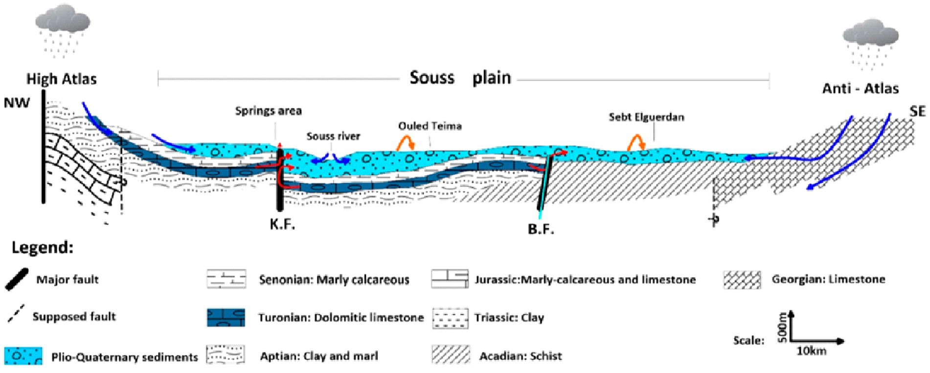
Figure 1. Schematic of groundwater flow in the Souss-Massa aquifer system: groundwater flow from the high Atlas Mountains (NW) to the Anti-Atlas Mountains (SE) across the Souss plain. The shallow Plio-Quaternary aquifer (sky blue) and the deep Turonian aquifer (desert blue) (Hssaisoune et al., 2019).
2.2 Overview of previous studies
The Souss-Massa River basin is located in the southwestern part of Morocco. It is characterized by a semi-arid climate, a growing population, where water resources are vulnerable to scarcity (Mansir et al., 2021). The region’s economy heavily depends on agriculture, fishery, and tourism (Abahous et al., 2018; Bouchaou et al., 2017; Guemouria et al., 2023).
Actually, Souss-Massa is a pivotal area for Morocco’s agriculture, accounting for approximately 90% of fruit and vegetable national exports (Hirich et al., 2015; Abou Ali et al., 2023). This region is not only a significant contributor to Morocco’s economy but also plays a vital role in the global food supply. In particular, Souss-Massa produces more than half of Morocco’s citrus exports and 85% of its vegetable exports, highlighting its importance in both local and international markets (Abou Ali et al., 2024; Choukr-allah et al., 2016).
Despite its agricultural importance, Souss-Massa faces critical challenges due to severe groundwater depletion and climate variability (Milewski et al., 2020).
The selection of the Souss-Massa basin as a case study is particularly relevant due to its status as one of Morocco’s most agriculturally developed regions, which significantly contributes to the national economy (Mansir et al., 2018), in addition to its vital role in the international markets through exportation of citrus, fruits, and vegetables (Choukr-allah et al., 2016). However, the region faces critical challenges related to water resource management, exacerbated by climate change and increasing agricultural demands. Previous studies have highlighted the impacts of drought on water quality and availability. Yet, there remains a notable gap in comprehensive research specifically addressing the effects of drought on water resources at the basin scale (Mansir et al., 2018). Our study aims to fill this gap by providing a detailed analysis of drought impacts on water resources.
3 Data collection and preparation
3.1 Precipitation data collection
The precipitation datasets were collected from local meteorological stations under the authority of the Hydraulic Basin Agency of Souss-Massa (ABHSM). Only 7 stations were selected for this study (Table 1). This selection is based on 3 criteria: (i) the distribution of meteorological stations over the Souss-Massa basin, (ii) the length of the rainfall data series, and (iii) the quality of the rainfall series data (fewer missing data). Definitely, for all hydrological research, it is important to analyze the spatiotemporal dynamics of precipitation. Certainly, the rain gauges of precipitation offer data quality at the locally scale. However, they usually do not provide global coverage; consequently, the time-series data may contain missing values. We found that data gaps in observed precipitation are quite low, ranging from 0.2 to 8% of the monthly records during the study period (1980–2023). To fulfill these, we incorporated data from The Integrated Multi-satellitE Retrievals for Global Precipitation Measurement (GPM IMERG-Final V06), denoted as GPM-F. This choice was recommended by Rachdane et al. (2022) as they confirmed the accuracy of GPM-F compared with the data observed in the Souss-Massa basin. Moreover, they highlighted the good performance of GPM-F in arid regions and recommended its use for diverse hydrological studies, including drought assessment, flood monitoring, and landslide forecasting. The GMP-F data were obtained from NASA’s website1.
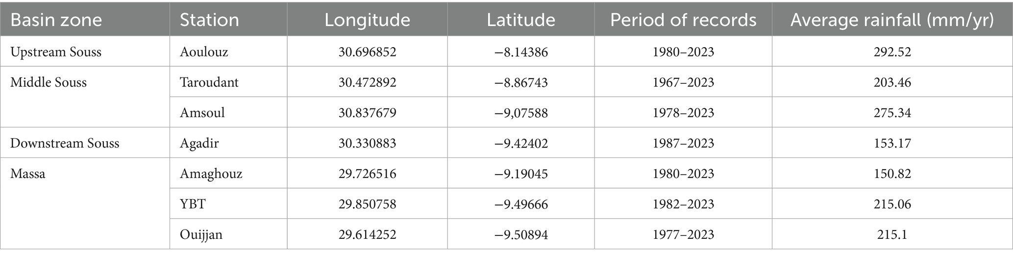
Table 1. Selected meteorological stations within the Souss-Massa basin.
3.2 Groundwater data collection
The piezometric level time series, used in this study, was also provided by the ABHSM. Groundwater level analysis was conducted using monthly data from 18 piezometers (Table 2), distributed over the Souss-Massa plain (Figure 2), covering a period from 1960 for the Souss basin and from 1970 for the Massa basin.
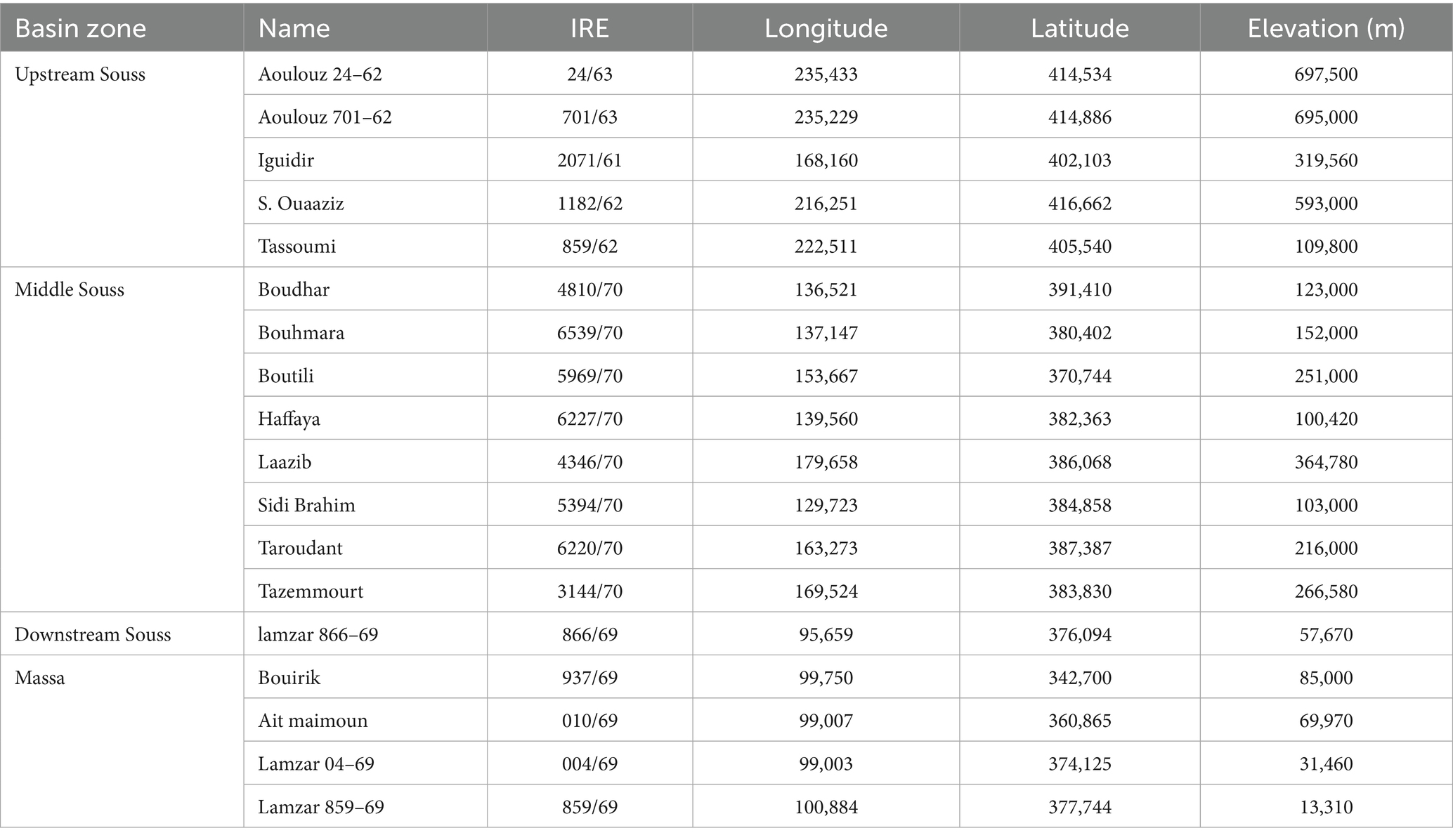
Table 2. Selected piezometers within the Souss-Massa plain.
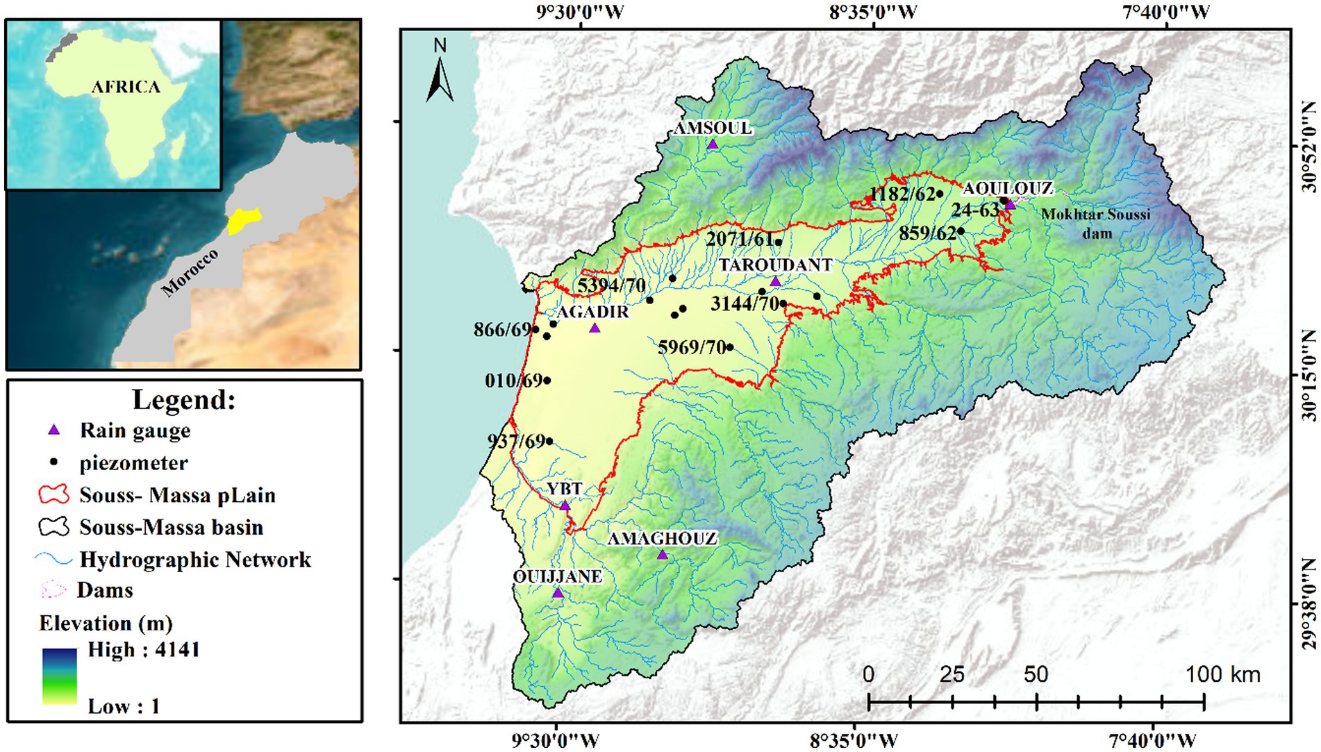
Figure 2. Location map of the studied area and ground measurement stations.
4 Methods
After addressing data gaps in rainfall and groundwater level depth, the study proceeded to calculate the Standardized Precipitation Index (SPI) to analyze the spatial–temporal distribution of meteorological drought. Similarly, groundwater drought was assessed using the Standardized Water Level Index (SWI). The selection of SWI was due to its enhanced sensitivity to seasonal variations and direct measurement of water levels and anomalies (Balacco et al., 2022), which are crucial for accurately reflecting the specific groundwater conditions of our study area. For the SWI computation, groundwater level time series were used starting from 1960 in the Souss basin and from 1977 for the Massa basin, enabling a robust analysis of long-term groundwater variability and trend. Subsequently, a comprehensive approach combining reliability analysis and SWI was employed for groundwater drought risk modeling.
Reliability analysis accounts for the safety and failure of a system regarding loads, which take into account the external effects (i.e., withdrawals and recharge), and resistance, which accounts for the system’s capacity (i.e., the aquifer’s ability to withstand these pressures without failing). Values of Groundwater Drought Risk (GDR) and Environmental Hazard Index (EHI) were generated and spatially distributed to assess groundwater risk for mild, moderate, severe, and extreme droughts covering the entire basin of Souss-Massa.
This methodology offers a replicable framework that can be adapted to evaluate groundwater drought dynamics in other arid and semi-arid regions facing similar challenges.
4.1 Standardized precipitation index (SPI)
The climate change assessment is based on precipitation trends analysis (moving average) and the standardized precipitation index (SPI) is proposed by Mckee et al. (1993) to identify the rainfall trends, and the drought frequency and duration, using only rainfall data.
The SPI is defined as the ratio of the difference of precipitation from the mean for a specified period and the standard deviation (Equation 1). Where the mean and standard deviation are determined from records (Mckee et al., 1993):
With P = monthly precipitation, = long-term mean precipitation, σP = standard deviation of precipitation.
A functional and quantitative definition of drought can be established for different time scales by utilizing the SPI as an indicator. According to the SPI, a drought event is identified as a continuous negative value. The onset of drought occurs when the SPI falls below zero for the first time, and it ends when the SPI becomes positive again. The intensity of the drought event is determined based on arbitrary categorizations associated with SPI values. These categories can be found in Table 3.
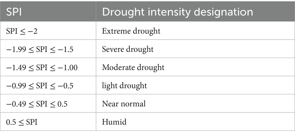
Table 3. Drought-designated bands based on SPI (Mckee et al., 1993).
4.2 SWI calculation
Hydrological droughts are initiated just like other droughts, by a shortage of precipitation and therefore a decline in groundwater recharge. The intensification of these droughts is exacerbated by mismanagement and excessive exploitation of aquifer resources, which exacerbates their impacts. In this study, the SWI proposed by Bhuiyan (2004) was used to evaluate groundwater deficit (Equation 2). The SWI builds on the SPI framework to compute standardized differences in groundwater depth (GWD), thereby quantifying anomalies in groundwater levels in relation to their long-term mean. SWI is often computed for its simplicity as follows:
Where: GWDi: the seasonal water level for observation (i), : seasonal mean of GWD, and 𝜎GWD the standard deviation of GWD.
The SWI was computed on a seasonal basis, focusing on the summer months (June–September), when groundwater stress is typically highest in the Souss-Massa basin. Each season includes four monthly groundwater depth observations, and the seasonal mean was used as the representative value for each year (Bhuiyan, 2004; Sadeghfam et al., 2018).
SWI ranges are designated to define drought bands to trigger appropriate management actions. As groundwater level is assessed downwards from the Earth’s surface, positive anomalies indicate drought, while negative anomalies reflect normal or wet conditions. Bands classified by Bhuiyan (2004) are given in Table 4, and their designated ranges are also mentioned.
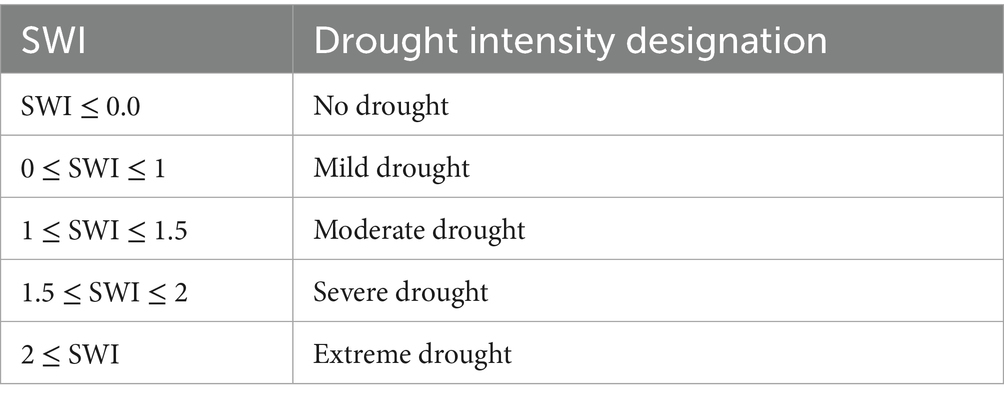
Table 4. Drought classification according to SWI (Bhuiyan, 2004).
4.3 GDR assessment using reliability analysis
4.3.1 The basic concept of reliability analysis
In reliability analysis, both the load (external stresses such as groundwater withdrawals) and the resistance (aquifer capacity to withstand these stresses) of a system are commonly influenced by multiple inherent random variables (i.e., abstractions). When loads on a system exceed its resistance, it becomes unreliable and is considered at risk. On the other hand, when resistance exceeds the load, the system is considered reliable (Arefinia et al., 2021). The reliability model is usually used to evaluate system performance under the worst load event, regardless of temporal dynamics; a probabilistic reliability analysis is a suitable framework to assess groundwater drought risk (GDR).
The methodology used in this work is inspired by the framework of Sadeghfam et al. (2018), which integrates historical groundwater data and probabilistic modeling to evaluate drought occurrence based on the interaction between Load (L) and Resistance (R).
4.3.2 Transforming reliability analysis into groundwater drought risk tools
A reliability analysis framework includes three modules: (i) Load (considering GWD’s external effects), (ii) Resistance (the system’s ability of adaptation), and (iii) the Performance Function, which combines the two to evaluate the probability of failure. The system is considered reliable if the load does not surpass the resistance. Otherwise, it is considered at risk of groundwater drought Sadeghfam et al. (2018).
4.3.2.1 Load module
The Load (L) is defined using groundwater depth data from the summer months, when aquifer stress is typically highest. This seasonal focus is critical, as drought impacts are most severe during periods of increased demand and reduced recharge.
To estimate the probability that the load exceeds the resistance, a probabilistic approach is employed. The observed summer groundwater depth values are first fitted to a probability distribution (normal or lognormal) based on statistical characteristics of the data. Following Sadeghfam et al. (2018), the Kolmogorov–Smirnov (K–S) test was applied to assess the goodness-of-fit, and the distribution with the lowest statistic was selected. To evaluate the temporal evolution of drought risk, the GWD time series is divided into two equal sub-periods, forming two distinct arrays: (GWD1sum) for the first half period and GWD2 sum for the second half.
From the fitted distribution, a random series of 10,000 synthetic groundwater depth values are generated to simulate potential load conditions using the Monte Carlo Simulation (MCS) which generates fully random samples, or the Latin Hypercube Sampling (LHS), which ensures better representation across the range of values by stratified sampling, both MCS and LHS were initially tested for generating random groundwater load scenarios. However, since both techniques produced similar results, MCS was retained as the default sampling method for its simplicity and wide application in hydrological risk modeling.
4.3.2.2 Resistance module
The Resistance (R) of the system is derived from the Annual Maxima (AM) series of observed groundwater depths (GWDAM). This reflects the system’s historical capacity to withstand stress (capture the most critical events for each year, making them suitable for identifying drought thresholds). After extracting the annual maxima for each piezometer, a statistical distribution (normal or lognormal) is fitted to the AM (Goodness-of-fit was also checked using the K–S test to ensure that the selected distribution adequately represented the data.), and for each designated drought class (mild, moderate, severe, extreme), a corresponding resistance threshold is defined using the inverse cumulative distribution function (CDF) of the fitted distribution as shown in Equation (3):
Where: −1 inverse CDF and P exceedance: the probability of occurrence for each drought class.
4.3.2.3 Performance function
The system’s performance is evaluated using a Performance Function (Z) defined as the difference between resistance (R) and load (L):
• When (Z ≥ 0), it means the system can handle the stress (i.e., no drought).
• When (Z < 0), the system cannot handle the stress, leading to groundwater drought.
The system’s reliability is assessed using the following essential equations (Equations 4, 5):
With, P f : Probability of failure, P s : non-failure, and Z: Performance function.
These equations allow for the evaluation of system reliability, considering the relationship between load, and resistance. The reliability index (β) is defined as the ratio of the mean (μZ) to the standard deviation (σZ) of the performance function, and is as shown in Equation (6):
Following the calculation of β, the probability of groundwater drought (GDR) is then determined using the standard normal cumulative distribution function (Φ) as defined in Equation (7):
This is repeated for each drought class, resulting in multiple GDR values (e.g., for mild, moderate, severe, and extreme drought conditions) at each observation well.
The methodology described in this section has been put into practice through the utilization of a MATLAB graphical user interface developed by Sadeghfam et al. (2018).
4.3.2.4 Environmental Hazard Index (EHI)
The Environmental Hazard Index (EHI) is used to assess how GDR evolves, as proposed by Sadeghfam et al. (2018). It captures temporal changes in risk by comparing early and late periods in the data. The time series of summer groundwater depth is divided into two equal sub-periods: (First half (e.g., 1980–2000): GDR1 and the Second half (e.g., 2001–2020): GDR2), each period has its own synthetic load series, and the GDR is computed independently for each. The EHI is then calculated as shown in Equation (8):
As shown in Table 5, the Environmental Hazard Index (EHI) allows for the interpretation of temporal trends in groundwater drought risk. As GDR is expressed in percentages because it represents a probability, EHI is also reported in percentage values.
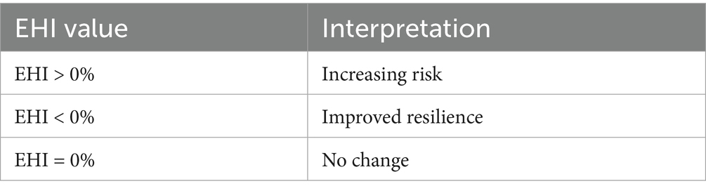
Table 5. EHI values interpretation.
4.3.3 Groundwater drought risk mapping
Groundwater drought risk (GDR) is evaluated for each piezometer and drought class using the performance function. The resulting GDR and Environmental Hazard Index (EHI) values are then spatially interpolated using Inverse Distance Weighting (IDW) to generate continuous maps. This approach highlights areas with higher or increasing drought vulnerability across the study region. The Figure 3 illustrates the methodology flow and different steps.
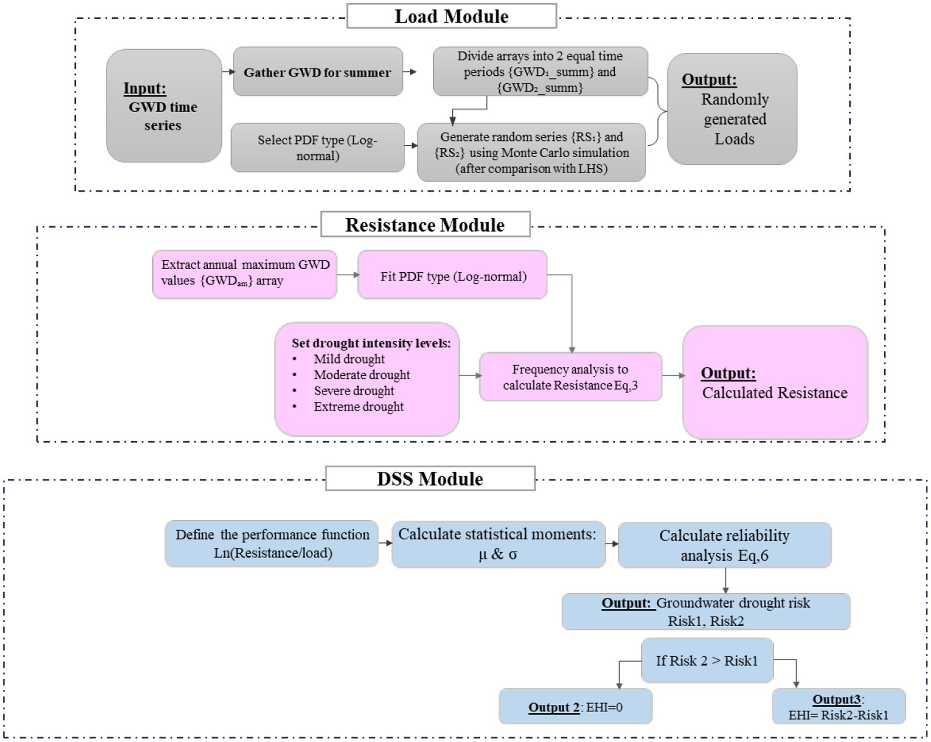
Figure 3. Flowchart of the used methodology (Adopted from Sadeghfam et al., 2018).
5 Results
5.1 Meteorological drought analysis
The evaluation of three-month accumulation periods reveals cyclical fluctuations that are not suitable for the precise prediction of drought events; such short periods may capture short-lived drought spells but can be less effective in characterizing prolonged and severe drought conditions. Instead, we used a longer-term cumulative rainfall approach (q = 12) for a more comprehensive analysis of drought characteristics in the basins.
The evolution of the SPI index for the seven selected rainfall stations over the period 1980–2020 is presented in Figure 4 (The full SPI series for all seven stations are given in Supplementary Figure S1). From the results, it is evident that most stations exhibit rainfall deficiency, with values reaching as low as −2 in some stations. The period from 2000 to 2010 is characterized by a deficit in rainfall at all stations, with SPI index values dropping below −1 (indicating severe drought), while positive values are slightly more frequent. After 2010, it is clear that all stations experienced an increase in humidity, with values greater than 2 observed in some stations. Nevertheless, rainfall subsequently becomes systematically deficient until the end of the observation period. Further comparative analysis of drought patterns between the Massa and Souss basins displays different intensities and durations, with the Souss basin showing higher SPI values, indicating lower drought intensity and longer wet periods. To highlight this evolution the mean SPI for the entire region was examined to offer an overview of the meteorological drought pattern in the research area (Figure 5). Since the end of the ‘80s, the Souss-Massa basin has experienced significant changes, manifested by alternating dry and wet periods; there are seven moderately wet periods with an average of SPI = 0.31 and one very wet event in 2010. The longest wet period ranged from 1987 to 1990, with an SPI value average not exceeding 1, followed by the longest dry period, which was extended from 1990 to 1995. Since 2010, climate variability has been well noticed and highlighted by successive increases and decreases of SPI values reflecting sometimes-dry conditions and sometimes-wet conditions.
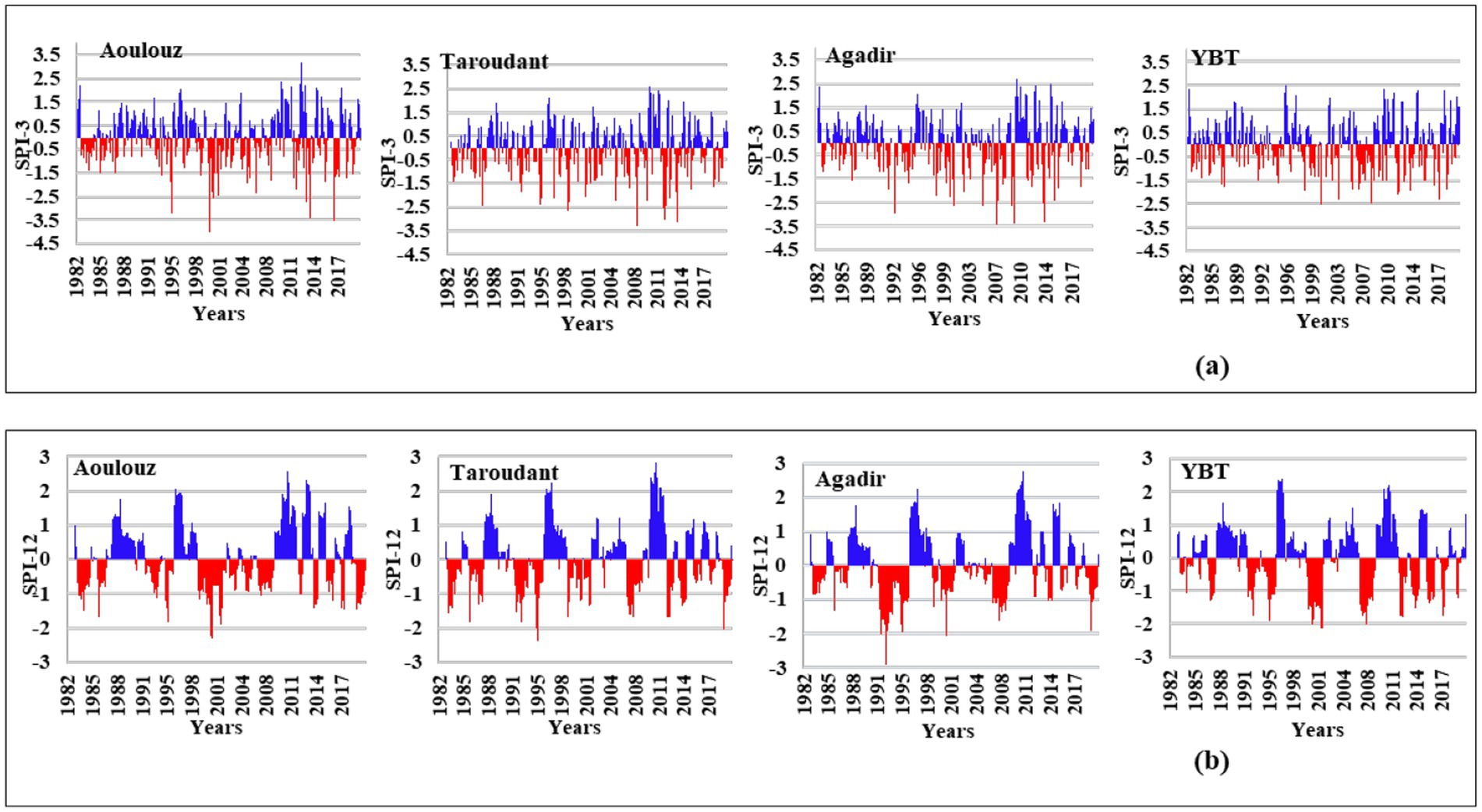
Figure 4. Standardized precipitation index (SPI) time series for the selected meteorological stations. (a) Represents short-term drought conditions, calculated over a 3-month period (SPI-3). (b) Represents long-term drought conditions, calculated over a 12-month period (SPI-12).
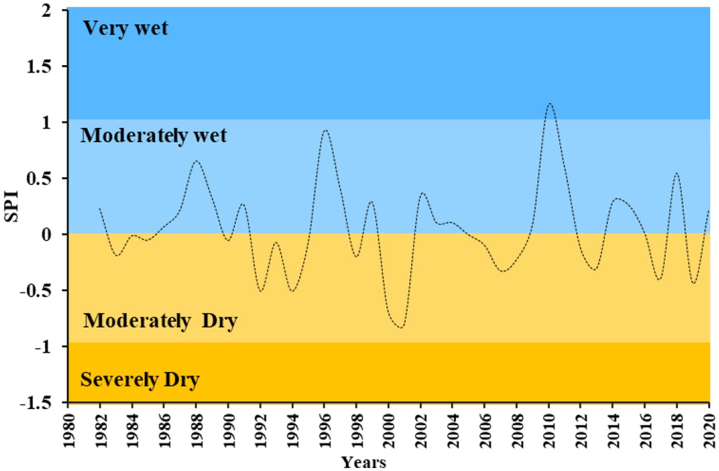
Figure 5. The mean of SPI-3 for meteorological stations in the Souss-Massa basin from January 1982 to December 2020.
5.2 Piezometric data
From the available data by the ABHSM, a total of 18 piezometers: 14 from Souss and 4 from Massa aquifer were selected. The choice of the piezometers to be investigated was based on their location and the availability of reliable long-term data, Figure 6 shows only 4 representative piezometers from this selection.
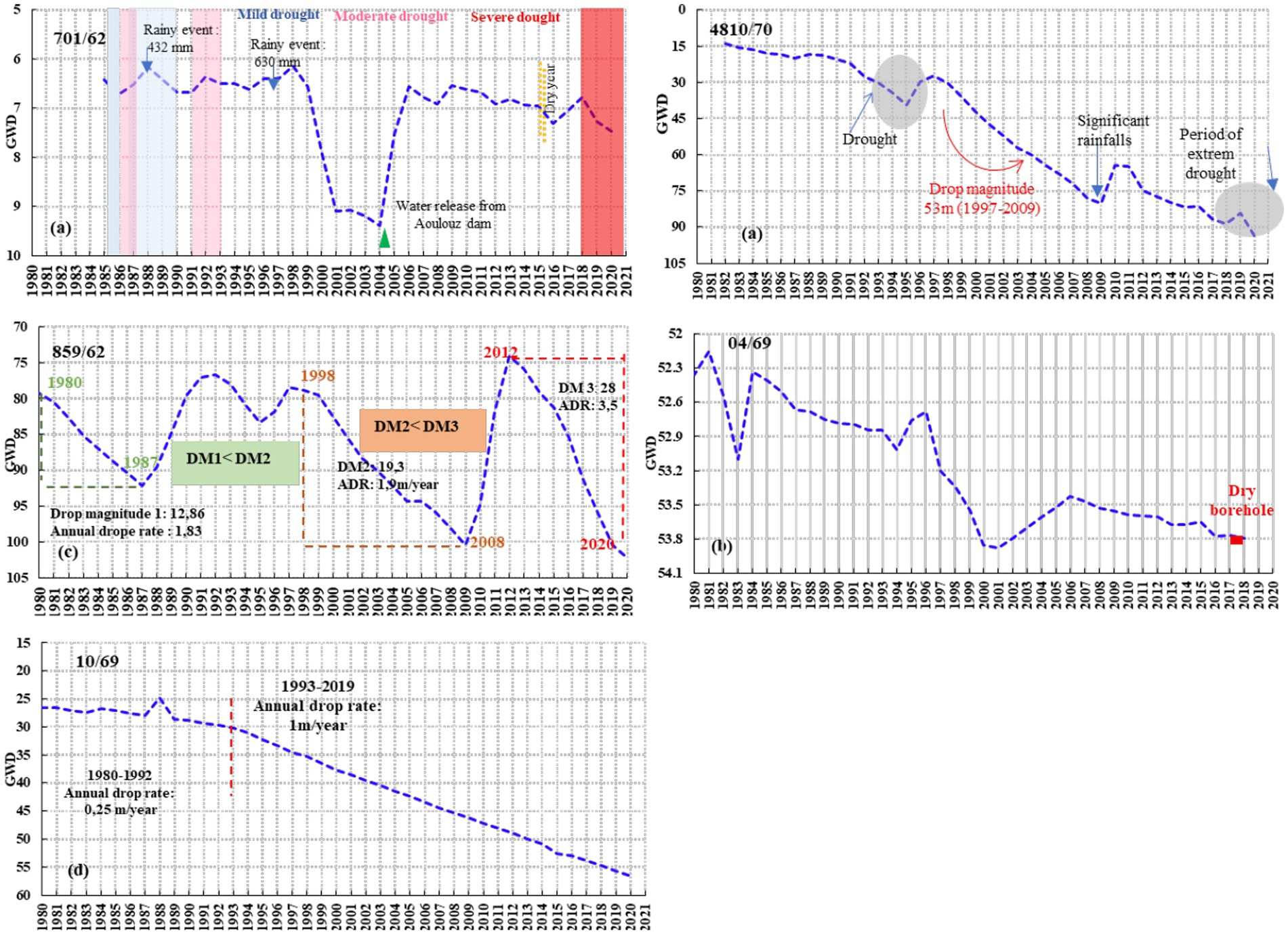
Figure 6. Groundwater depth variation (GWL, in meters) across different regions of the Souss-Massa Basin, with time series from 1980 to 2020. (a) Upstream Souss, (b) Middle Souss, (c) Downstream Souss, and (d) Massa Basin.
The piezometric level variation in the Souss basin can be divided into two groups. The first group exhibits minimal variations and after a decrease, they return to their initial position (Figure 6a). This includes for example piezometer 701/62. As for the other piezometer, 859/62 despite its location in the Upstream Souss, it experienced a considerable decline in groundwater levels, but during 1996 there was a notable increase in groundwater level. The rapid drop rates of 1.9 m/year (1998–2008) and 3.5 m/year (2012–2020) indicate a significant influence (Figure 6a).
The other borehole 4810/70 is located in the Middle Souss; its piezometric level continuously decreases in the long term (Figure 6b), and there is a temporary light rise in groundwater levels that should be noted.
Concerning the Massa basin (Figure 6d), an important agricultural area, the boreholes consistently show a gradual decline in water levels over the years. This decline averaged one meter per year in last decades. It is worth noting that some piezometers in the Massa basin were already dry by 2018.
5.3 Meteorological drought impact on groundwater drought
The Groundwater level is measured from the surface, and SWI was calculated for groundwater drought assessment, with positive anomalies indicating drought conditions and negative anomalies indicating normal conditions. A cross-correlation analysis was performed on the SPI and the SWI while varying the duration of the SPI at different time scales.
As shown in Figure 7, since 1965 in the Souss Basin, the trend in the SWI values has been generally toward negative values, indicating wet periods. However, from the early 2000s onwards, the region has experienced a change toward mild drought (0.5 < SWI < 1). The correlation between the SWI and SPI was found to be maximum when the accumulation period is 1 month.
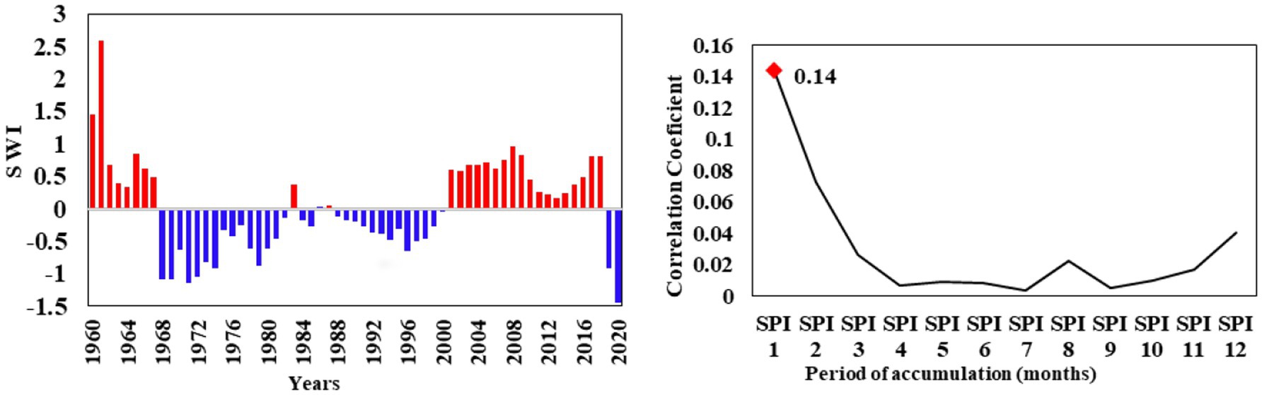
Figure 7. Standardized water-level index (SWI) anomalies and correlation with the standardized precipitation index (SPI) for the Souss basin.
In the Massa basin, a consistent trend toward dryer conditions has been observed since 1999 (Figure 8). The years 2019 and 2020 were marked by severe groundwater drought intensity (SWI = 1.8). The results showed that the accumulation period required to achieve the maximum correlation between the SPI and SWI time series is 4 months for the Massa basin. However, the correlation between the SPI and SWI remains very low (r = 0.07).
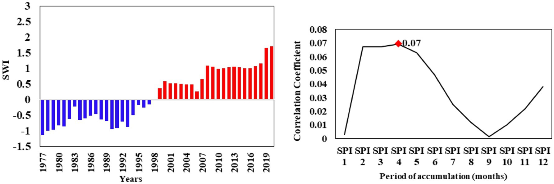
Figure 8. Standardized water-level index (SWI) anomalies and correlation with the standardized precipitation index (SPI) for the Massa basin.
5.4 Resistance in Souss-Massa basin
Figure 9 illustrates the spatial distribution of resistance across various drought bands, and it can serve as a drought vulnerability.
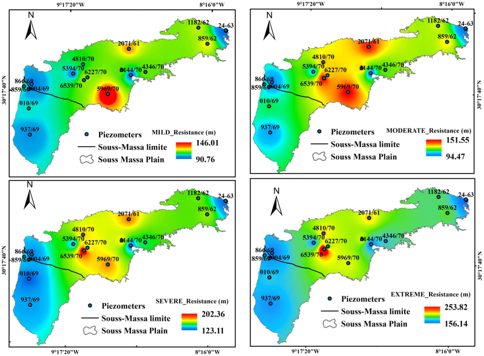
Figure 9. Spatial distribution of resistance under different drought bands in the Souss-Massa aquifer.
Our results show that the Massa aquifer demonstrates low resistance, withstanding only a maximum of 54 meters of variation under mild, moderate, and extreme drought conditions. An 18.5% increase in resistance is observed during extreme drought, reaching 63 meters. For the middle Souss region, resistance to loads went to a maximum of 146.04 m under mild drought, 151.56 m for moderate drought, 202 m for severe drought, and 254.09 m under extreme drought. As in the upstream Souss, resistance values vary from 7.7 to 164.98 m across different drought bands. Thereafter, the middle and upstream Souss regions exhibit diverse resistance values, indicating varying sensitivities to groundwater fluctuations.
5.5 Groundwater drought risk (GDR)
Figure 10 illustrates the spatial distribution of Groundwater Drought Risk (GDR) across various drought severity bands (Mild, Moderate, Severe, and Extreme) in the Souss-Massa basin. These maps offer a detailed visualization of how drought risk varies geographically and across different levels of drought severity. Under the mild drought band, the GDR values range from 19.2 to 57.94%, we note that the Massa basin exhibits the highest GDR values within this category, suggesting a significant susceptibility to mild drought conditions. These high GDR values in the Massa basin (indicated by the red and orange areas) imply a higher probability and potential frequency of experiencing mild droughts. For the moderate drought band, the values range from 3.07 to 45.64%. As the severity of drought increases to moderate, there is a noticeable decrease in GDR values, reflecting a reduced frequency but potentially greater impact of each event. The downstream and middle Souss regions display moderate GDR values (green to yellow zones), indicating a balanced risk, while lower than in the Massa basin (Red color). The severe and extreme drought categories show a further reduction in GDR values; 1.2 to 40.86% and 0.57 to 36.62% respectively; highlighting the infrequent but potentially destructive nature of these droughts. Despite their low frequency, these droughts could have critical impacts, particularly in areas like the Massa basin where GDR values are still relatively high compared to other regions.
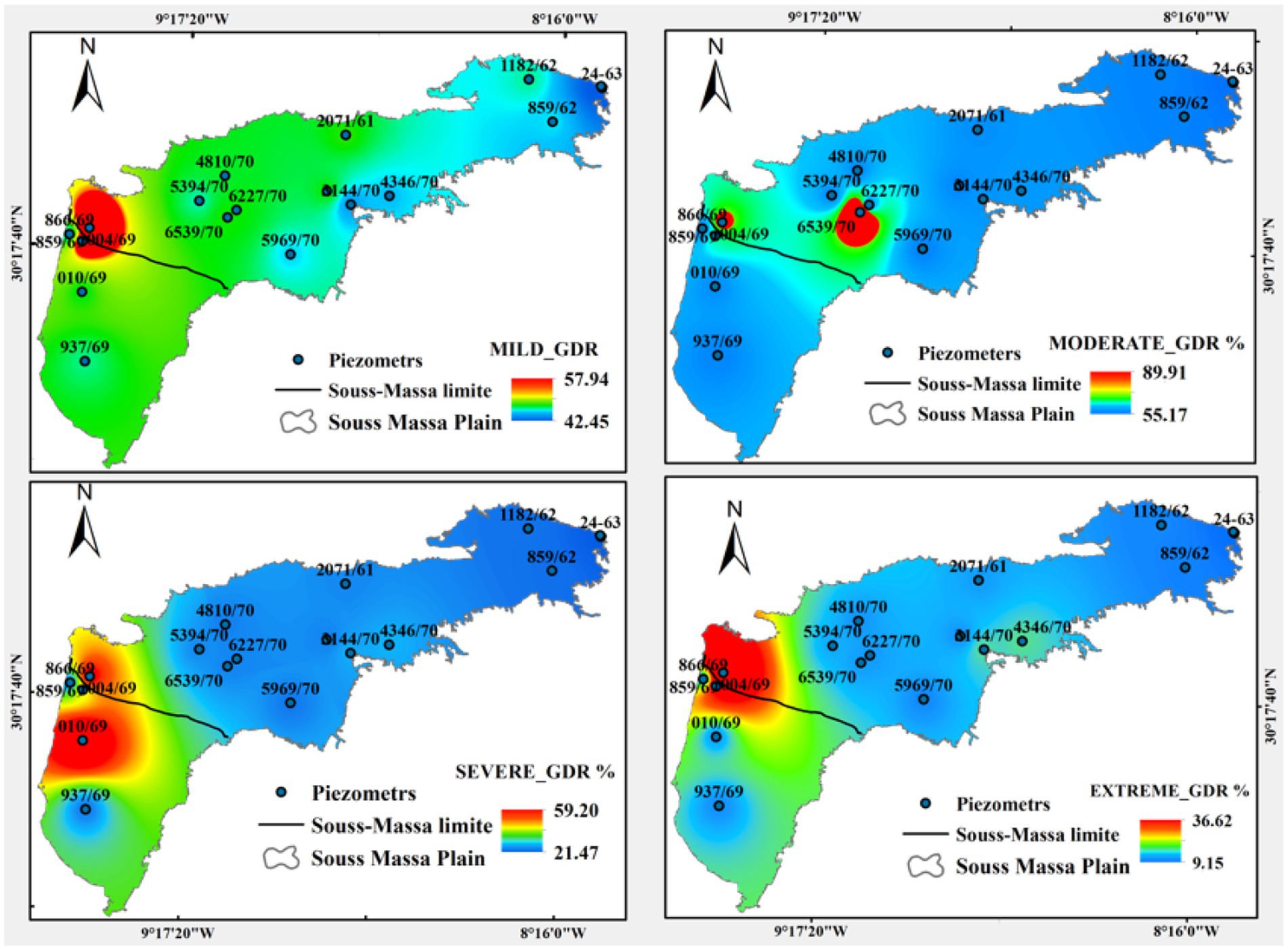
Figure 10. Spatial distribution of GDR under different drought bands in the Souss-Massa aquifer.
5.6 Environmental Hazard Index in Souss-Massa basin
Figure 11 illustrate the spatial distribution of EHI within Souss-Massa plain. The results showed elevated EHI values, particularly in the Massa basin, where drought risk reached over 80% under mild drought conditions. Downstream Souss and Middle Souss regions exhibited drought risks between 60 and 70%. The Upstream Souss region had a comparatively lower risk, with values below 40%. For other drought bands, the results indicated a concerning situation in the Massa basin, with a sharp change in groundwater levels.
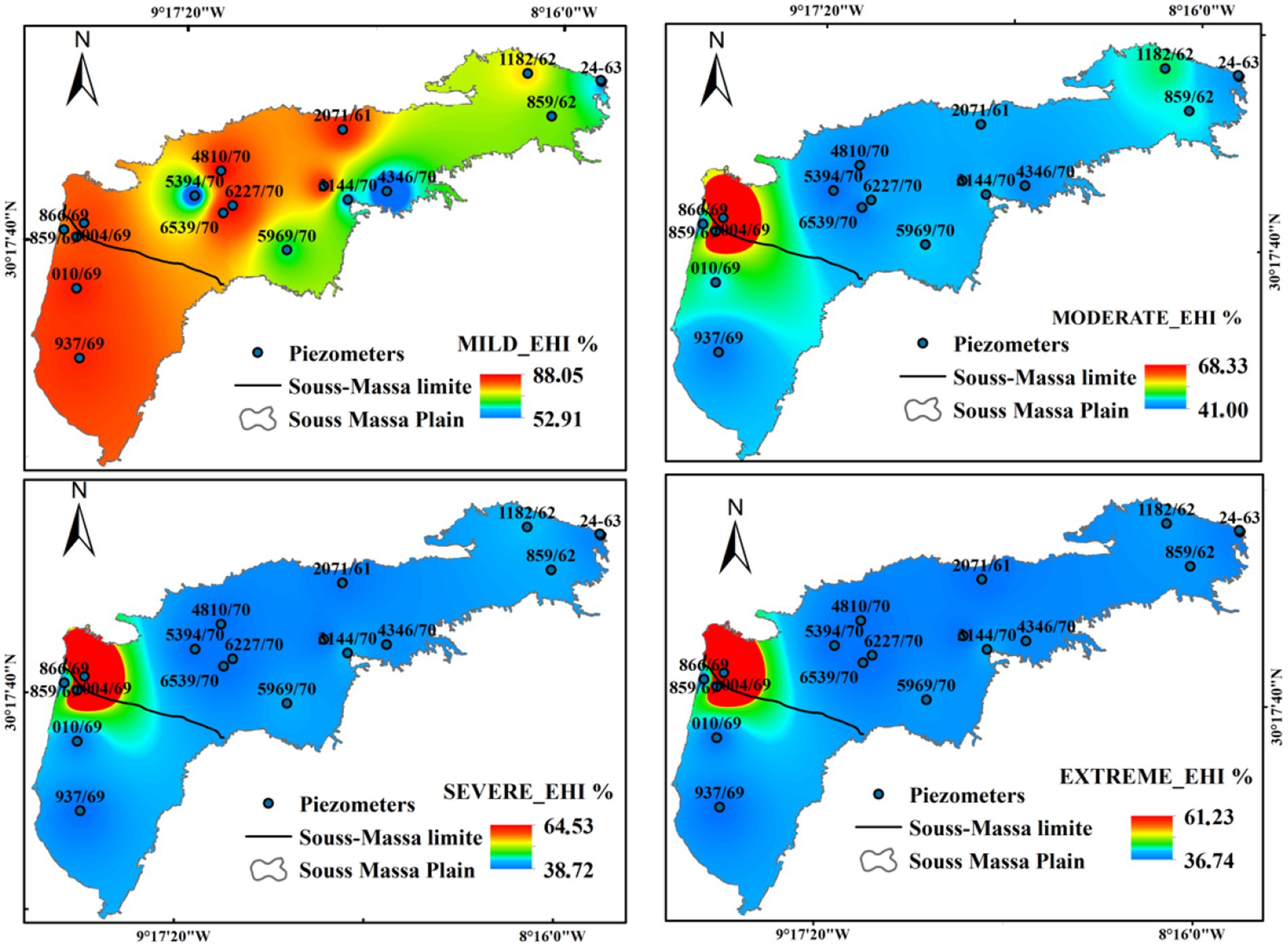
Figure 11. Spatial distribution of EHI under different drought bands in the Souss-Massa aquifer.
6 Discussion
6.1 Variability in precipitation and its impacts on the Souss-Massa basin
The Souss-Massa basin, a vital agricultural area in Morocco, has experienced significant changes in climatic and hydrological conditions. The spatial and temporal variability in rainfall observed in our results is consistent with previous studies. Bouchaou et al. (2011) and Ait Brahim et al. (2016) reported substantial differences in rainfall distribution across the Souss Massa basin. Similarly, Abahous et al. (2018) documented a long-term decline in rainfall since the 1960s, highlighting a shift toward more arid climatic conditions. These changes have important implications for both water availability and agricultural productivity.
The analysis of meteorological drought conditions in the Souss-Massa basin reveals a clear upward trend in both frequency and severity of drought events in recent decades. This is evidenced by SPI values frequently falling below normal, which denote severe drought conditions. Our findings are consistent with the observations made by Balaghi et al. (2010), who documented a marked increase in drought occurrences in Morocco since 1980, highlighting a shift from experiencing one dry year every 15 years to one every 3 years. A local study by Ait Brahim et al. (2017), highlighted a significant rise in the frequency of dry years since the 1970s in the Souss-Massa basin, emphasizing the climatic shifts that threaten sustainable water management practices in the region. Moreover, our SPI-12 analysis indicates that the drought conditions observed are not episodic or isolated but part of an enduring pattern of rainfall deficits. This aligns with the findings of Bijaber et al. (2018), who emphasized the impact of climate change on the frequency and intensity of droughts in Morocco, all in the same way, previous studies conducted by Bouchaou et al. (2011); Mansir et al. (2018); and Seif-Ennasr et al. (2017) and Hssaisoune et al., 2021 confirm the recurrent fluctuation of wet and dry cycles in the Souss-Massa basin. The historical patterns described by Abahous et al. (2018) further illustrate alternating cycles of drought since 1980s.
The comparative analysis of drought patterns between the Massa and Souss basins further elucidates the spatial variability in drought intensity and duration, in agreement with the findings of Yoo et al. (2020), who highlighted that spatial heterogeneity plays a key role in the propagation and persistence of drought events. Rainfall variability in the Souss-Massa basin is influenced by several geographic factors. The High Atlas Mountains enhance rainfall through orographic effects, while the inland plains are drier due to the rain shadow effect. Elevation, valley orientation, and the influence of the Atlantic Ocean further explain the spatial contrasts observed (Hssaisoune et al., 2017).
These meteorological droughts have a direct impact on groundwater resources, with effects that vary depending on the location and land use. Groundwater in the Souss basin is recharged primarily by the High and Anti-Atlas Mountains (Bouchaou et al., 2008; Hssaisoune et al., 2017). In recharge-favored zones, such as near High Atlas, the aquifer response to droughts is buffered by natural infiltration (Hssaisoune et al., 2020). Piezometer 701/62 (Upstream Souss), for example, exhibits recovery during wet periods and dam releases like those in 2004 (Gouahi et al., 2024; Bouragba et al., 2011), reflecting the aquifer’s resilience to meteorological variability. In contrast, Middle and downstream areas in addition to the Massa plain, saw a rapid and prolonged groundwater level declines, due to limited recharge and high abstraction rates. These spatial variations are further explored through the Pearson correlation between SPI and SWI values. Although this correlation is relatively weak, this does not negate the impact of rainfall shortage on the recharge process (Bouimouass et al., 2020). On the contrary, the water’s decline still reflects the cumulative effect of reduced rainfall combined with the anthropogenic pressures.
6.2 Implications for water management in the Souss-Massa
The methodological framework used in this study is built upon the reliability concept, where aquifer resistance and external loads are integrated to evaluate the probability of failure and quantify the Groundwater Drought Risk (GDR). This approach allows for distinguishing areas that are more likely to experience groundwater drought under different stress conditions. The Environmental Hazard Index (EHI), on the other hand, serves as an important metric for the assessment of the increasing risk over time. Together, these indicators provide complementary insights into the spatiotemporal dynamics of groundwater stress in Souss-Massa.
Our results clearly illustrate that the Massa aquifer exhibits relatively low resistance, making it more vulnerable to groundwater depletion and drought. The resistance values, particularly during extreme drought conditions, are concerning, as the aquifer can only withstand groundwater fluctuations of up to 63 meters. This low level of resilience is further highlighted by the complete drying-up of two boreholes in the region, a powerful indicator of the aquifer’s inability to cope with prolonged drought conditions. These results highlight the critical state of the Massa aquifer and underscore the urgent need to adopt water management strategies to mitigate the effects of future droughts. In contrast, the middle and upstream Souss regions display a broader range of resistance values, suggesting a more diverse response to groundwater fluctuations. For example, in the middle Souss, resistance reached up to 254.09 meters under extreme drought conditions, reflecting a higher capacity to withstand significant groundwater stress. This suggests that certain areas of the Souss aquifer have a greater ability to maintain stability, even in the face of extreme changes in groundwater levels.
The variation in resistance values between the Souss and Massa regions underscores the heterogeneity of the aquifer system. The higher resistance observed in the Souss suggests a more robust system capable of withstanding larger changes in groundwater depth, while the Massa aquifer remains more fragile and susceptible to drought impacts. These findings align with those of Mansir et al. (2021), contributing to a growing body of research that deepens our understanding of the vulnerability of the Souss-Massa basin to water scarcity.
Building on that concept of vulnerability (resistance), GDR quantifies the risk of groundwater drought by evaluating aquifer resistance to the intensity of hydrological stress. When the stress exceeds the resistance, the risk of drought increases. This allows GDR to spatially highlight areas where groundwater systems are most likely to fail. Higher GDR values indicate a greater probability of experiencing severe droughts, although these events tend to occur less frequently. Conversely, lower GDR values suggest a lower susceptibility to severe drought, but these areas may experience more frequent drought events, albeit with less severe impacts. This inverse relationship between the frequency and severity of drought events, as indicated by the GDR values, has been corroborated by earlier research, including studies by Roshni et al. (2019) and Xu et al. (2021).
The spatial distribution of GDR values across the Souss-Massa basin illustrates a clear distinction between the Souss and Massa regions. The Souss upstream region exhibits relatively low GDR values, suggesting a lower risk of groundwater drought. This area appears to be more resilient, likely due to its higher resistance to groundwater fluctuations. As we move downstream in the Souss basin, GDR values gradually increase but remain within manageable levels, indicating that the region is still relatively resilient to drought conditions. In contrast, the Massa basin stands out with significantly higher GDR values, indicating a much greater risk of groundwater drought. The higher GDR values in Massa suggest that the region is more vulnerable to severe drought impacts. This increased risk is likely due to the lower resistance values observed in the Massa aquifer, which struggles to cope with the stress imposed by prolonged drought conditions. The drying-up of boreholes, as previously noted, underscores this vulnerability.
When examining the drought categories, the GDR values reflect the region’s vulnerability across different severity levels. Mild and moderate droughts are relatively frequent across the basin, with GDR values indicating that these events are likely to occur regularly. However, these droughts tend to have less severe impacts, particularly in the Souss region, where resistance to groundwater fluctuations is higher. On the other hand, severe and extreme droughts are much less frequent but can have catastrophic effects, particularly in the Massa basin, where groundwater resources are more vulnerable. The relationship between GDR and resistance is also evident in these findings. Areas with small resistance values, such as the Massa basin, tend to have higher GDR values, reflecting their increased risk of drought. This is a normal correlation in groundwater systems: lower resistance implies a lower capacity to withstand fluctuations in groundwater levels, leading to a higher probability of system failure during drought conditions (Hssaisoune et al., 2016; Sadeghfam et al., 2018; Roshni et al., 2019).
EHI complements this assessment by tracing the evolution of drought risk over time. The index shows a dramatic increase in groundwater stress in the Massa basin over the past two decades, with EHI values exceeding 80% under mild drought conditions. This observation aligns with the drying-up of two boreholes in the area by 2018, further underscoring the severity of the situation. The Souss basin, particularly the Downstream and Middle Souss regions, shows moderately high EHI values. Although the risk is not as severe as in the Massa basin, the steady increase in drought risk suggests that these regions are also becoming more vulnerable to groundwater depletion and associated environmental hazards. Meanwhile, upstream Souss remains more resilient, with GDR and EHI values both below 40%. However, changes in climate or water use could alter this status in the future. There are also contrasting patterns, such as around piezometer 937/69, where high GDR but low EHI suggests temporary drought exposure with good recovery potential, likely due to seasonal recharge. Conversely, piezometers 04/69, 859/69, and 866/59 report high GDR and EHI, signifying chronic drought risk and heightened hazard. This includes the threat of saltwater intrusion in coastal zones, as confirmed by Ez-zaouy et al. (2022, 2023) and Malki et al. (2016).
6.3 Advantages, limitations and perspectives
Despite the diversity of drought indices, SPI remains the most used in drought monitoring for its robustness and its low data inputs (World Meteorological Organization (WMO) and Global Water Partnership (GWP), 2016). Thus, this index is highlighted by WMO as the starting point of meteorological drought and serves as an early warning signal. Furthermore, its multi-scalar nature allows the evaluation of droughts over different timescales (e.g., 1, 3, 12 months), which is essential to capture short-term meteorological versus long-term hydrological droughts. However, SPI does not account for evapotranspiration, which is critical in semi-arid regions like Souss Massa where water loss through ET is high. In addition, SPI relies on the assumption that precipitation follows a stationary probability distribution, which may be invalid under shifting climate conditions or long-term trends (Stagge et al., 2015). This limitation was acknowledged in our study, and the integration of SPEI is highlighted as a perspective for future research.
In this study, the Standardized Precipitation Index (SPI) was correlated with groundwater levels using the Standardized Water-level Index (SWI) to explore the linkage between meteorological and groundwater droughts (Figures 7, 8). While this approach offers insights into the broader trends of drought propagation, the observed low correlation (r = 0.07) likely reflects multiple interacting factors (Schreiner-McGraw and Ajami, 2021). In particular, ABHSM reports indicate piezometric declines of 1–2.5 m/year, with cumulative drops of up to 30 m in 30 years, reflecting a structural deficit of 260–300 Mm3/year (ABHSM, 2018). Irrigation accounts for more than 85–90% of withdrawals, mainly citrus and vegetable crops (Mansir et al., 2018), and groundwater abstraction increased dramatically from 747 Mm3 in 2007 to 4,884 Mm3 in 2020 (Guemouria et al., 2023). Isotopic studies (Hssaisoune et al., 2017) also confirm that modern recharge is spatially limited and delayed. Together, these studies provide proof that explains why groundwater drought in Souss-Massa is not solely climate-driven but strongly shaped by anthropogenic demand.
Resistance and GDR values and their spatial distribution demonstrate high spatial variability across the basin, reflecting heterogeneous responses to drought events. Overall, the risk and vulnerability to groundwater drought are disproportionately concentrated in middle and downstream regions (Figures 9, 10), which can be attributed to several interconnected factors:
1. Intensive Agricultural Practices: Middle-basin areas are dominated by large-scale monoculture agriculture, where unsustainable groundwater abstraction often exceeds natural recharge rates (Ait El Kadi et al., 2025). This imbalance is characteristic of intensively irrigated systems, where long-term groundwater depletion occurs due to mismatched extraction and replenishment dynamics (Scanlon et al., 2023)
2. Upstream Dam Impacts: Dams constructed upstream disrupt the natural flow of Oued Souss, severely limiting seasonal fluvial recharge processes. While such infrastructure is often designed to support managed aquifer recharge (MAR), studies highlight that artificial recharge efforts frequently yield only localized and transient benefits, failing to counteract regional aquifer depletion (Gouahi et al., 2022).
3. Socio-Economic Stressors: Downstream regions host dense urban centers and populations (e.g., Taroudant, Agadir, Inezgan-Ait Melloul) reliant on groundwater for domestic, industrial, and agricultural needs. Thus, rapid urbanization and population growth in such areas amplify aquifer stress and its vulnerability to drought events.
7 Conclusion
This study provides an attempt to comprehensive assessment of the groundwater drought in the Souss-Massa basin. By conducting a methodology that integrates SPI, SWI, and a statistical approach, we provided a valuable understanding of the relation between meteorological and groundwater drought. Furthermore, our investigation sheds light on the vulnerability of the region to groundwater drought. Indeed, the findings of this work reveal an identifiable trend toward drier conditions in the Massa aquifer, particularly since 1999, ending with the onset of severe drought episodes in 2019. The correlation between SPI and SWI highlights the complexity of groundwater drought, which is influenced by a variety of factors other than just precipitation patterns.
The analysis of resistance values in different aquifer regions reveals distinct sensitivities to groundwater fluctuations. The Massa basin exhibits lower resistance values, indicating its vulnerability to drought impacts. Conversely, the middle and upstream Souss have variable resistance values, demonstrating their ability to maintain stability under variable water table conditions.
The assessment of GDR offers valuable insights regarding the risk profile of different regions. The upstream Souss region has lower GDR values, indicating a relatively lower risk profile, while downstream areas experience a gradual increase in risk. In contrast, the Massa basin has significantly higher GDR values, meaning that it is more vulnerable to the impacts of severe drought.
The EHI findings underline the urgency of appropriate management strategies, particularly in the Massa basin, where the risk of groundwater drought can exceed 80% in mild drought conditions and up to 60% in other drought intensities.
Faced with the problem of water scarcity in the Souss-Massa basin, the ABHSM has entailed considerable initiatives to prevent overexploitation, improve irrigation efficiency, and develop non-conventional water resources. These initiatives, which include the reuse of treated wastewater and desalination, as well as participatory management contracts for aquifer conservation, especially in the Massa basin, have had a positive limited impact. However, these efforts are still inadequate because of the chronic water shortage in the Souss-Massa basin and continuous overexploitation. The spatial variability in resistance values across the region highlights the need for tailored water management strategies, as different areas of the basin exhibit different levels of resilience to drought. To ensure related ecosystem balance and sustainable groundwater management in vulnerable areas like the Massa aquifer, future research should prioritize improving water use efficiency and developing innovative, sustainable management solutions tailored to the specific sensitivities identified in this study. Moreover, drought could be better managed by establishing an early warning system and incorporating socio-economic and environmental vulnerabilities into the modeling approach. This integrated framework will enable policymakers and stakeholders to prioritize high-risk areas and implement adaptive measures to enhance resilience to future droughts.
Data availability statement
The datasets generated and/or analyzed during the current study are available from the corresponding author upon reasonable request.
Author contributions
SG: Formal analysis, Writing – original draft, Visualization, Data curation, Validation, Methodology, Investigation, Software, Resources, Writing – review & editing, Conceptualization. MH: Visualization, Project administration, Validation, Methodology, Writing – review & editing, Conceptualization, Supervision, Data curation. YA: Validation, Project administration, Visualization, Writing – review & editing, Funding acquisition, Supervision. MA: Visualization, Conceptualization, Writing – review & editing, Validation. MN: Data curation, Validation, Writing – review & editing. LB: Project administration, Resources, Data curation, Visualization, Supervision, Writing – review & editing, Funding acquisition, Validation, Investigation.
Funding
The author(s) declare that financial support was received for the research and/or publication of this article. The authors thank the Moroccan Ministry of Higher Education, Scientific Research and Innovation and the OCP Foundation who, partially, funded this work through the APRD research program (GEANTech).
Acknowledgments
The authors acknowledge the data support from the Hydraulic Basin Agency of Souss-Massa. This paper presents part of the outputs of the AgreeMed and Water4Med projects, financed by MERSRI within the framework of the PRIMA-S2 program (EU). This project is also realized within the CHARISMA project under the support of Academy Hassan II of Sciences and Techniques.
Conflict of interest
The authors declare that the research was conducted in the absence of any commercial or financial relationships that could be construed as a potential conflict of interest.
Generative AI statement
The authors declare that no Gen AI was used in the creation of this manuscript.
Any alternative text (alt text) provided alongside figures in this article has been generated by Frontiers with the support of artificial intelligence and reasonable efforts have been made to ensure accuracy, including review by the authors wherever possible. If you identify any issues, please contact us.
Publisher’s note
All claims expressed in this article are solely those of the authors and do not necessarily represent those of their affiliated organizations, or those of the publisher, the editors and the reviewers. Any product that may be evaluated in this article, or claim that may be made by its manufacturer, is not guaranteed or endorsed by the publisher.
Supplementary material
The Supplementary material for this article can be found online at: https://www.frontiersin.org/articles/10.3389/frwa.2025.1628691/full#supplementary-material
Footnotes
1. ^https://gpm.nasa.gov/data/directory, Accessed on 3 February 2024
References
Abahous, H., Ronchail, J., Sifeddine, A., Kenny, L., and Bouchaou, L. (2018). Trend and change point analyses of annual precipitation in the Souss-Massa region in Morocco during 1932–2010. Theor. Appl. Climatol. 134, 1153–1163. doi: 10.1007/s00704-017-2325-0
ABHSM (2018). Plan Directeur d’Amenagement Integre des Ressources en Eau (PDAIRE) des basins du Souss-Massa. Inédit Report 105.
Abou Ali, A., Bouchaou, L., Er-Raki, S., Hssaisoune, M., Brouziyne, Y., Ezzahar, J., et al. (2023). Assessment of crop evapotranspiration and deep percolation in a commercial irrigated citrus orchard under semi-arid climate: combined Eddy-covariance measurement and soil water balance-based approach. Agric. Water Manag. 275:107997. doi: 10.1016/j.agwat.2022.107997
Abou Ali, A., Bouchaou, L., Hssaisoune, M., Aqil, S., and Brouziyne, Y. (2024). Exploring the effect of different irrigation levels on fruit quality in a commercial drip irrigated clementine orchard under semi-arid climate conditions. Irrig. Sci.
Ait Brahim, Y., Saidi, M. E. M., Kouraiss, K., Sifeddine, A., and Bouchaou, L. (2017). Analysis of observed climate trends and high-resolution scenarios for the 21st century in Morocco. J. Materials Environ. Sci. 8, 1375–1384.
Ait Brahim, Y., Seif-Ennasr, M., Malki, M., N’da, B., Choukr-allah, R., Morjani, Z. E., et al. (2016). Assessment of climate and land use changes: impacts on groundwater resources in the Souss-Massa River basin. The Souss-Massa River Basin, 121–142. doi: 10.1007/698_2016_71
Ait Dhmane, L., Saidi, M. E., Moustadraf, J., Rafik, A., and Hadri, A. (2024). Spatiotemporal characterization and hydrological impact of drought patterns in northwestern Morocco. Front. Water 6:1463748. doi: 10.3389/frwa.2024.1463748
Ait El Kadi, M., Bouchaou, L., El Hafyani, M., Gouahi, S., Meskour, B., Fernandez, V., et al. (2025). Impact of agricultural development policies on land use, water resources and rural livelihoods in the semi-arid environment of Souss Basin in Morocco. EGU General Assembly 2025. doi: 10.5194/egusphere-egu25-581
Arefinia, A., Bozorg-Haddad, O., and Keller, A. A. (2021). “Risk, uncertainty, and reliability in water resources management,” in Essential tools for water resources analysis, planning, and management. ed. O. Bozorg-Haddad (Singapore: Springer), 445–469.
Attar, O., Brouziyne, Y., Bouchaou, L., and Chehbouni, A. (2022). A critical review of studies on water resources in the Souss-Massa Basin, Morocco: envisioning a water research agenda for local sustainable development. Water 14:1355. doi: 10.3390/w14091355
Balacco, G., Alfio, M. R., and Fidelibus, M. D. (2022). Groundwater drought analysis under data scarcity: the case of the Salento aquifer (Italy). Sustainability 14:707. doi: 10.3390/su14020707
Balaghi, R., Badjeck, M.-C., Bakari, D., De Pauw, E., De Wit, A., Defourny, P., et al. (2010). Managing climatic risks for enhanced food security: key information capabilities. Procedia Environ. Sci. 1, 313–323. doi: 10.1016/j.proenv.2010.09.020
Bhuiyan, C. (2004). Various drought indices for monitoring drought condition in Aravalli terrain of India. In Proceedings of the XXth ISPRS congress, Istanbul, Turkey (pp. 12–23).
Bijaber, N., Hadani, D., Saidi, M., Svoboda, M., Wardlow, B., Hain, C., et al. (2018). Developing a remotely sensed drought-monitoring indicator for Morocco. Geosciences 8:55. doi: 10.3390/geosciences8020055
Bloomfield, J. P., and Marchant, B. P. (2013). Analysis of groundwater drought building on the standardised precipitation index approach. Hydrol. Earth Syst. Sci. 17, 4769–4787. doi: 10.5194/hess-17-4769-2013
Bloomfield, J. P., Marchant, B. P., Bricker, S. H., and Morgan, R. B. (2015). Regional analysis of groundwater droughts using hydrograph classification. Hydrol. Earth Syst. Sci. 19, 4327–4344. doi: 10.5194/hess-19-4327-2015
Bouchaou, L., Choukr-Allah, R., Hirich, A., Seif-Ennasr, M., Malki, M., Abahous, H., et al. (2017). Climate change and water valuation in Souss-Massa region: management and adaptive measures. European Water 60, 203–209.
Bouchaou, L., Michelot, J. L., Vengosh, A., Hsissou, Y., Qurtobi, M., Gaye, C. B., et al. (2008). Application of multiple isotopic and geochemical tracers for investigation of recharge, salinization, and residence time of water in the Souss-Massa aquifer, southwest of Morocco. J. Hydrol. 352, 267–287. doi: 10.1016/j.jhydrol.2008.01.022
Bouchaou, L., Tagma, T., Boutaleb, S., and Hssaisoune, M. (2011). Climate change and its impacts on groundwater resources in Morocco: The case of the Souss-Massa basin. In Climate change effects on groundwater resources: A global synthesis of findings and recommendations, 129.
Bouimouass, H., Fakir, Y., Tweed, S., and Leblanc, M. (2020). Groundwater recharge sources in semiarid irrigated mountain fronts. Hydrol. Process. 34, 1598–1615. doi: 10.1002/hyp.13685
Bouragba, L., Mudry, J.-N., Bouchaou, L., Hsissou, Y., Krimissa, M., Tagma, T., et al. (2011). Isotopes and groundwater management strategies under semi-arid area: case of the Souss upstream basin (Morocco). Appl. Radiat. Isot. 69, 1084–1093. doi: 10.1016/j.apradiso.2011.01.041
Bouras, E., Jarlan, L., Er-raki, S., Albergel, C., Richard, B., Balaghi, R., et al. (2020). Linkages between rainfed cereal production and agricultural drought through remote sensing indices and a land data assimilation system: A case study in Morocco. Remote Sensing, 12:4018.
Brouziyne, Y., Abouabdillah, A., Chehbouni, A., Hanich, L., Bergaoui, K., Rachael, M., et al. (2020). Assessing hydrological vulnerability to future droughts in a Mediterranean watershed: combined indices-based and distributed modeling approaches. Water 12:2333. doi: 10.3390/w12092333
Calverley, C. M., and Walther, S. C. (2022). Drought, water management, and social equity: Analyzing Cape Town, South Africa’s water crisis. Front. Water 4:910149. doi: 10.3389/frwa.2022.910149
Choukr-Allah, R., Nghira, A., Hirich, A., and Bouchaou, L. (2016). “Water resources master plan for sustainable development of the Souss-Massa River basin” in The Souss-Massa River basin, Morocco. eds. R. Choukr-Allah, R. Ragab, L. Bouchaou, and D. Barceló (Cham: Springer International Publishing), 1–26.
Collin, J. J., Margat, J., and Gennai, A. (1994). Cartographie de la résistance à la sécheresse des principaux systèmes aquifères régionaux à nappe libre. Ministère de l'Industrie, des Postes et Télécommunications et du Commerce Extérieur.
Dahhane, Y., Ongoma, V., Hadri, A., Kharrou, M. H., Hakam, O., and Chehbouni, A. (2025). Probabilistic linkages of propagation from meteorological to agricultural drought in the north African semi-arid region. Frontiers in Water 7:1559046. doi: 10.3389/frwa.2025.1559046
Danni, S. O., Bouchaou, L., Elmouden, A., and Ait, Y. (2019). Assessment of water quality and nitrate source in the Massa catchment (Morocco) using δ15N and δ18O tracers. Appl. Radiat. Isot. 154:108859. doi: 10.1016/j.apradiso.2019.108859
El Bouazzaoui, I., Lamhour, O., Ait Brahim, Y., Najmi, A., and Bougadir, B. (2024). Three decades of groundwater drought research: evolution and trends. Water 16:743. doi: 10.3390/w16050743
Eljechtimi, A. (2025). Morocco's livestock hit by consecutive droughts, agriculture minister says. Available online at: https://www.reuters.com/world/africa/moroccos-livestock-hit-by-consecutive-droughts-agriculture-minister-says-2025-02-13/
Elkouk, A., El Morjani, Z. E. A., Pokhrel, Y., Chehbouni, A., Sifeddine, A., Thober, S., et al. (2021). Multi-model ensemble projections of soil moisture drought over North Africa and the Sahel region under 1.5, 2, and 3 °C global warming. Clim. Chang. 167:52. doi: 10.1007/s10584-021-03202-0
Elkouk, A., Pokhrel, Y., Satoh, Y., and Bouchaou, L. (2022). Implications of changes in climate and human development on 21st-century global drought risk. J. Environ. Manag. 317:115378. doi: 10.1016/j.jenvman.2022.115378
El-Yazidi, M., Dafouf, S., El-Yazidi, O., and Benabdelhadi, M. (2024). Characterization of climatic drought in the Souss-Massa watershed (Morocco) using the standardized precipitation index (SPI). BIO Web of Conf. 109:01032. doi: 10.1051/bioconf/202410901032
Ez-Zaouy, Y., Bouchaou, L., Saad, A., Hssaisoune, M., Brouziyne, Y., Dhiba, D., et al. (2022). Morocco’s coastal aquifers: recent observations, evolution and perspectives towards sustainability. Environ. Pollut. 293:118498. doi: 10.1016/j.envpol.2021.118498
Ez-Zaouy, Y., Bouchaou, L., Schreiber, H., Montcoudiol, N., Kalberkamp, U., Oumarou, S., et al. (2023). Combined geophysical methods to investigate seawater intrusion in the Souss-Massa coastal area, Morocco. Groundwater for Sustain. Develop. 21:100915. doi: 10.1016/j.gsd.2023.100915
Feng, G. (2023). Propagation of meteorological drought to agricultural and hydrological droughts in the tropical Lancang–Mekong River basin. Remote Sens 15:5678. doi: 10.3390/rs15245678
Fniguire, F., Laftouhi, N. E., Saidi, M. E., Zamrane, Z., El Himer, H., and Khalil, N. (2017). Spatial and temporal analysis of the drought vulnerability and risks over eight decades in a semi-arid region (Tensift basin: Morocco). Theor. Appl. Climatol. 130, 321–330. doi: 10.1007/s00704-016-1873-z
Gao, B.-C. (1996). NDWI—A normalized difference water index for remote sensing of vegetation liquid water from space. Remote Sens. Environ. 58, 257–266. doi: 10.1016/S0034-4257(96)00067-3
Gouahi, S., Hssaisoune, M., Qurtobi, M., Nehmadou, M., Bouaakaz, B., Boudhair, H., et al. (2024). “Managed aquifer recharge in a semi-arid basin: a case study from the Souss aquifer, Morocco” in Managed groundwater recharge and rainwater harvesting. eds. D. Saha, K. G. Villholth, and M. Shamrukh (Singapore: Springer Nature Singapore), 129–150.
Gouahi, S., Hssaisoune, M., Qurtobi, M., Nehmadou, M., Bouaakkaz, B., and Bouchaou, L. (2022). Assessment of managed aquifer recharge within the Souss river basin. AGU Fall Meeting Abstracts 2022, H55J–H0697J.
Gu, L., Chen, J., Yin, J., Xu, C. Y., and Chen, H. (2020). Drought hazard transferability from meteorological to hydrological propagation. J. Hydrol. 585:124761. doi: 10.1016/j.jhydrol.2020.124761
Guemouria, A., Chehbouni, A., Belaqziz, S., Epule Epule, T., Ait Brahim, Y., El Khalki, E. M., et al. (2023). System dynamics approach for water resources management: a case study from the Souss-Massa Basin. Water 15:15081506. doi: 10.3390/w15081506
Hadri, A., El, M., Saidi, M., and Boudhar, A. (2021). Multiscale drought monitoring and comparison using remote sensing in a Mediterranean arid region: a case study from west-Central Morocco. Arab. J. Geosci. 14:118. doi: 10.1007/s12517-021-06493-w
Hertig, E., and Tramblay, Y. (2017). Regional downscaling of Mediterranean droughts under past and future climatic conditions. Glob. Planet. Chang. 151, 36–48. doi: 10.1016/j.gloplacha.2016.10.015
Hirich, A., Choukr-allah, R., Rami, A., and El-Otmani, M. (2015). “Feasibility of using desalination for irrigation in the Souss Massa region in the south of Morocco” in Recent Progress in desalination, environmental and marine outfall systems. eds. M. Baawain, B. Choudri, M. Ahmed, and A. Purnama (Cham: Springer).
Hssaisoune, M., Bouchaou, L., Da B, N., Malki, M., Abahous, H., and Fryar, A. E. (2017). Isotopes to assess sustainability of overexploited groundwater in the Souss–Massa system (Morocco). Isot. Environ. Health Stud. 53, 298–312. doi: 10.1080/10256016.2016.1254208
Hssaisoune, M., Bouchaou, L., Matsumoto, T., Araguas, L., Kraml, M., and Aggarwal, P. (2019). New evidences on groundwater dynamics from the Souss-Massa system (Morocco): insights gained from dissolved noble gases. Appl. Geochem. 109:104395. doi: 10.1016/j.apgeochem.2019.104395
Hssaisoune, M., Bouchaou, L., Sifeddine, A., Bouimetarhan, I., and Chehbouni, A. (2020). Moroccan groundwater resources and evolution with global climate changes. Geosciences 10:81. doi: 10.3390/geosciences10020081
Hssaisoune, M., Boutaleb, S., Benssaou, M., Bouaakkaz, B., and Bouchaou, L. (2016). Physical geography, geology, and water resource availability of the Souss-Massa River basin. Handbook Environ. Chemistry 53, 27–56. doi: 10.1007/698_2016_68
Hssaisoune, M., Boutaleb, S., Tagma, T., Benssaou, M., Beraaouz, M., Karaoui, I., et al. (2021). Geophysical data revealing the control of geological structures in the El Gouna springs in Souss river valley in Morocco. Groundw. Sustain. Dev. 15:100669. doi: 10.1016/j.gsd.2021.100669
Hu, Y., Feng, M., and Yuan, X. (2023). The role of human activities in the weakening of the propagation relationship between meteorological and hydrological droughts in the Heihe River basin. Hydrol. Process. 37:e14946. doi: 10.1002/hyp.14946
Jung, H., Won, J., Kang, S., and Kim, S. (2022). Characterization of the propagation of meteorological drought using the copula model. Water 14:3293. doi: 10.3390/w14203293
Khan, R., Gilani, H., Iqbal, N., and Shahid, I. (2020). Satellite-based (2000–2015) drought hazard assessment with indices, mapping, and monitoring of Potohar plateau, Punjab, Pakistan. Environ. Earth Sci. 79:16. doi: 10.1007/s12665-019-8751-9
Kogan, F. N. (1995). Application of vegetation index and brightness temperature for drought detection. Adv. Space Res. 15, 91–100. doi: 10.1016/0273-1177(95)00079-T
Lebrini, Y., Boudhar, A., Htitiou, A., Hadria, R., Lionboui, H., Bounoua, L., et al. (2020). Remote monitoring of agricultural systems using NDVI time series and machine learning methods: a tool for an adaptive agricultural policy. Arab. J. Geosci. 13:684. doi: 10.1007/s12517-020-05789-7
Li, Q., He, P., He, Y., Han, X., Zeng, T., Lu, G., et al. (2020). Investigation to the relation between meteorological drought and hydrological drought in the upper Shaying River basin using wavelet analysis. Atmos. Res. 234:104743. doi: 10.1016/j.atmosres.2019.104743
Liu, B., Zhou, X., Li, W., Lu, C., and Shu, L. (2016). Spatiotemporal characteristics of groundwater drought in Jiangsu Province. China. Water 8:480. doi: 10.3390/w8110480
Loukas, A., and Vasiliades, L. (2004). Probabilistic analysis of drought spatiotemporal characteristics in Thessaly region, Greece. Natural Hazards Earth System Sci. 4, 719–731. doi: 10.5194/nhess-4-719-2004
Malki, M., Bouchaou, L., Mansir, I., Benlouali, H., and Nghira, A. (2017). Wastewater treatment and reuse for irrigation as alternative resource for water safeguarding in Souss-Massa region, Morocco. European Water 59, 365–371.
Malki, M., Redouane, C. A., Bouchaou, L., Ait Brahim, Y., Abdelaziz, H., and Reichert, B. (2016). Evolution of groundwater quality in intensive agricultural zone: case of Chtouka-Massa aquifer, Morocco. Arabian J. Geosci. 9:552. doi: 10.1007/s12517-016-2592-6
Mansir, I., Bouchaou, L., Chebli, B., Ait Brahim, Y., and Choukr-Allah, R. (2021). A specific indicator approach for the assessment of water resource vulnerability in arid areas: the case of the Souss-Massa region (Morocco). Hydrol. Sci. J. 66, 1151–1168. doi: 10.1080/02626667.2021.1924379
Mansir, I., Bouchaou, L., Choukr-Allah, R., Chebli, B., and El Otmani, M. (2018). “Groundwater resources scarcity in Souss-Massa region and alternative solutions for sustainable agricultural development” in Groundwater and global change in the Western Mediterranean area (Cham: Springer International Publishin), 189–197.
Marchant, B. P., and Bloomfield, J. P. (2018). Spatio-temporal modelling of the status of groundwater droughts. J. Hydrol. 564, 397–413. doi: 10.1016/j.jhydrol.2018.07.009
McKee, T. B., Doesken, N. J., Kleist, J., and Nolan, J. (1993). The relationship of drought frequency and duration to time scales. Am. Meteorol. Soc. 105, 818–824. doi: 10.1002/jso.23002
Milewski, A., Seyoum, W. M., Elkadiri, R., and Durham, M. (2020). Multi-scale hydrologic sensitivity to climatic and anthropogenic changes in northern Morocco. Geosciences 10:13. doi: 10.3390/geosciences10010013
Mishra, A. K., and Singh, V. P. (2010). A review of drought concepts. J. Hydrol. 391, 202–216. doi: 10.1016/j.jhydrol.2010.07.012
Mtilatila, L., Bronstert, A., and Vormoor, K. (2022). Temporal evaluation and projections of meteorological droughts in the greater Lake Malawi Basin, Southeast Africa. Front. Water 4:1041452. doi: 10.3389/frwa.2022.1041452
Peters, E., Torfs, P. J. J. F., van Lanen, H. A. J., and Bier, G. (2003). Propagation of drought through groundwater: a new approach using linear reservoir theory. Hydrol. Process. 17, 3023–3040. doi: 10.1002/hyp.1274
Rachdane, M., Khalki, E. M. E., Saidi, M. E., Nehmadou, M., Ahbari, A., and Tramblay, Y. (2022). Comparison of high-resolution satellite precipitation products in sub-Saharan Morocco. Water 14:3336. doi: 10.3390/w14203336
Roshni, T., Choudhary, S., Jha, M. K., and Mandal, N. (2019). “Probability-based approach for evaluating groundwater risk assessment in Sina basin, India” in Handbook of probabilistic models (pp. [pages not provided]) (Elsevier).
Sadeghfam, S., Ehsanitabar, A., Khatibi, R., and Daneshfaraz, R. (2018). Investigating risk of groundwater drought occurrences by using reliability analysis. Ecol. Indic. 94, 170–184. doi: 10.1016/j.ecolind.2018.06.055
Scanlon, B. R., Fakhreddine, S., Rateb, A., de Graaf, I., Famiglietti, J., Gleeson, T., et al. (2023). Global water resources and the role of groundwater in a resilient water future. Nature Rev. Earth Environ. 4, 87–101. doi: 10.1038/s43017-022-00378-6
Schreiner-McGraw, A. P., and Ajami, H. (2021). Delayed response of groundwater to multi-year meteorological droughts in the absence of anthropogenic management. J. Hydrol. 603:126917. doi: 10.1016/j.jhydrol.2021.126917
Seif-Ennasr, M., Abdelaziz, H., El Morjani, Z. E., and Choukr-allah, R. (2017). “Assessment of global change impacts on groundwater resources in Souss-Massa basin” in Water resources in arid areas: The way forward (Cham: Springer International Publishing), 115–140.
Stagge, J. H., Tallaksen, L. M., Gudmundsson, L., Van Loon, A. F., and Stahl, K. (2015). Candidate distributions for climatological drought indices (SPI and SPEI). Int. J. Climatol. 35, 4027–4040. doi: 10.1002/joc.4267
Tahiri, A., Amraoui, F., Sinan, M., Bouchaou, L., Berrada, F., and Benjmel, K. (2022). Influence of climate variability on water resource availability in the upper basin of Oum-Er-Rabiaa, Morocco. Groundwater Sustain. Develop. 19:100814. doi: 10.1016/j.gsd.2022.100814
Tallaksen, L. M., Hisdal, H., and van Lanen, H. A. J. (2009). Space–time modelling of catchment scale drought characteristics. J. Hydrol. 375, 363–372. doi: 10.1016/j.jhydrol.2009.06.032
Tanarhte, M., Vries, A. J. D., Zittis, G., and Chfadi, T. (2024). Severe droughts in North Africa: a review of drivers, impacts and management. Earth Sci. Rev. 250:104701. doi: 10.1016/j.earscirev.2024.104701
Tramblay, Y., Koutroulis, A., Samaniego, L., Vicente-Serrano, S. M., Volaire, F., Boone, A., et al. (2020). Challenges for drought assessment in the Mediterranean region under future climate scenarios. Earth Sci. Rev. 210:103348. doi: 10.1016/j.earscirev.2020.103348
Van Lanen, H. A. J., Peters, E., and Hisdal, H. (2000). “Definition, effects and assessment of groundwater droughts” in Drought and drought mitigation in Europe. eds. J. V. Vogt and F. Somma, vol. 14 (Dordrecht: Springer Netherlands), 49–61.
Wang, W., Ertsen, M. W., Svoboda, M. D., and Hafeez, M. (2016). Propagation of drought: from meteorological drought to agricultural and hydrological drought. Adv. Meteorol. 2016:1. doi: 10.1155/2016/6547209
Wilhite, D. A. (1993). Planning for drought: A methodology. in Drought assessment, management, and planning: Theory and case studies. Boston, MA: Springer US. pp. 87–108.
Wilhite, D. A., and Glantz, M. H. (1985). Understanding the drought phenomenon: the role of definitions. Water Int. 10, 111–120. doi: 10.1080/02508068508686328
World Meteorological Organization. (2020). State of climate services 2020: risk information and early warning systems (WMO-no. 1252). World meteorological Organization Available online at: https://wmo.int/publication-series/2020-state-of-climate-services-risk-information-and-early-warning-systems
World Meteorological Organization (WMO) and Global Water Partnership (GWP) (2016). “Handbook of drought indicators and indices” in Integrated drought management tools and guidelines series 2. eds. M. Svoboda and B. A. Fuchs.
Xu, C., Ke, Y., Zhou, W., Luo, W., Ma, W., Song, L., et al. (2021). Resistance and resilience of a semi-arid grassland to multi-year extreme drought. Ecol. Indic. 131:108139. doi: 10.1016/j.ecolind.2021.108139
Yeh, H. F. (2021). Spatiotemporal variation of the meteorological and groundwater droughts in Central Taiwan. Frontiers in Water 3:636792. doi: 10.3389/frwa.2021.636792
Yoo, J., So, B.-J., Lee, J.-H., and Kim, T.-W. (2020). Analysis of drought propagation from meteorological to hydrological drought considering spatio-temporal moving pattern of drought events. KSCE J. Civil Environ. Eng. Res. 40, 135–143. doi: 10.12652/KSCE.2020.40.2.0135
Zhao, A., Xiang, K., Zhang, A., and Zhang, X. (2022). Spatial-temporal evolution of meteorological and groundwater droughts and their relationship in the North China plain. J. Hydrol. 610:127903. doi: 10.1016/j.jhydrol.2022.127903
Keywords: Groundwater drought, Standardized Precipitation Index (SPI), Standardized Water Level Index (SWI), Groundwater Drought Risk (GDR), Environmental Hazard Index (EHI), reliability analysis, Souss-Massa Basin
Citation: Gouahi S, Hssaisoune M, Ait Brahim Y, Ait El Kadi M, Nehmadou M and Bouchaou L (2025) Assessment of groundwater drought risk in arid regions using standardized indices and reliability analysis. Front. Water. 7:1628691. doi: 10.3389/frwa.2025.1628691
Edited by:
Munir Ahmad Nayak, National Institute of Technology, IndiaReviewed by:
Moctar Diaw, Cheikh Anta Diop University, SenegalMehvish Hameed, National Institute of Technology, India
Copyright © 2025 Gouahi, Hssaisoune, Ait Brahim, Ait El Kadi, Nehmadou and Bouchaou. This is an open-access article distributed under the terms of the Creative Commons Attribution License (CC BY). The use, distribution or reproduction in other forums is permitted, provided the original author(s) and the copyright owner(s) are credited and that the original publication in this journal is cited, in accordance with accepted academic practice. No use, distribution or reproduction is permitted which does not comply with these terms.
*Correspondence: Soumia Gouahi, c291bWlhLmdvdWFoaUBlZHUudWl6LmFjLm1h