 Sarmistha Saha
 Olga D. Kucher2
- 1Department of Biotechnology, Institute of Applied Sciences & Humanities, GLA University, Mathura, Uttar Pradesh, India
- 2Department of Environmental Management, Institute of Environmental Engineering, RUDN University, Moscow, Russia
Precision agriculture (PA) is a data-driven, technology-enabled farming management strategy that monitors, quantifies, and examines the requirements of specific crops and fields. A key aim of precision agricultural technologies is to optimize crop yield and quality, while also working to lower operating costs and minimize environmental impact. This approach not only enhances productivity but also promotes sustainable farming practices. In PA, it is essential to leverage effective monitoring through sensing technologies, implement robust management information systems, and proactively address both inter- and intravariability within cropping systems. Crop yield simulations using deep learning and machine learning (ML) techniques aid in understanding the combined effects of pests, nutrient and water shortages, and other field variables during the growing season. On the other hand, remote sensing techniques such as lidar imagery, radar, and multi- and hyperspectral data presents valuable opportunities to enhance yield predictions by improving the understanding of soil, climate, and other biophysical factors affecting crops. This paper aims to highlight key gaps and opportunities for future research, focusing on the evolving landscape of remote sensing and machine learning techniques employed to enhance predictions of crop yield. In future, PA is likely to include more focused use of sensor platforms and ML techniques can enhance the effectiveness of agricultural practices. Additionally, the development of hybrid systems that combine diverse ML approaches and signal processing techniques will pave the way for more innovative and efficient solutions in the field.
1 Introduction
The World Health Organization (WHO) estimates that by 2030 and beyond, heat stress, starvation, and disease would cause 250,000 fatalities yearly, demonstrating the real and dangerous effects of climate change (WHO, 2023). In addition to the uncertain and unforeseen future that climate change would bring, it is predicted that by 2050, there will be 9.6 billion people on the planet (UN Report, 2024). Malnutrition is already a major global concern, and climate change is making food production even more stressful globally. Despite their dependence on steady and regular weather patterns, agricultural practices nonetheless have a major role in climate change. The use of nitrogen-based fertilizers, on-farm waste management, fuel consumption, and biological sources (such as enteric fermentation by cattle) account for the majority of agricultural emissions (ECCC, 2021).
Precision agriculture (PA), which uses modern methods to increase crop yield while consuming the fewest resources possible, represents a substantial departure from conventional agricultural systems (Karunathilake et al., 2023; Rebouh et al., 2023a). Precision agriculture is a data-driven approach that analyzes and manages field variability using a variety of tools, including sensors, drones, GPS guidance systems, and machine learning algorithms (Linaza et al., 2021). In order to make well-informed decisions pertaining to certain areas of their farm, farmers can use this technique to evaluate changes in crop health, soil composition, and moisture levels (Case-Cohen, 2018) (Figure 1). By effectively using farm inputs like fertilizer, herbicides, and water through real-time data gathering and analysis, precision agriculture seeks to increase food production worldwide while enhancing yield, efficiency, and environmental sustainability (Gawande et al., 2023). By utilizing automation, data analytics, and technological advancements, PA also referred to as smart farming or precision farming; symbolizes a paradigm shift in agricultural management. This multidisciplinary approach enables farmers make informed decisions, modify interventions, and maximize resource utilization based on real-time data insights.
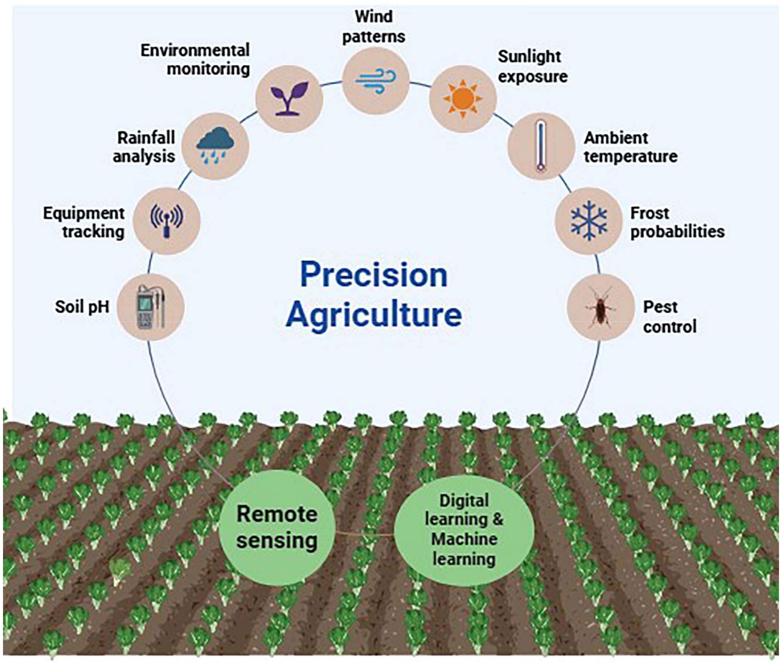
Figure 1. Graphical representation of factors involved in crop model predictor using deep learning and remote sensing.
In the field of PA and crop production, accurate yield prediction plays a vital role in promoting social and economic stability, alongside enhancing food security (Karunathilake et al., 2023). By anticipating crop yields in advance of harvest, farmers could strategically plan and mitigate production risks. Accurate yield forecasting plays a crucial role in enhancing food waste reduction, improving operational efficiency, and promoting sustainable agriculture. This approach not only optimizes resources but also contributes to a more sustainable agricultural future. The pre-harvest yield estimation figures assist farmers in making critical choices, such as figuring out how much fertilizer to use. Furthermore, possible hazards such as insect infestation and drought occurrence can be recognized in advance so that the appropriate measures can be taken (Lobell et al., 2015).
The potential to create yield prediction techniques that are more accurate grows along with the volume and availability of data. Thus, using artificial intelligence (AI) with big data management approaches has been shown to be a successful strategy for handling this massive amount of data. AI’s capacity to process vast volumes of data has recently drawn significant interest in precision agriculture (El Behairy et al., 2023). A useful technique that can improve crop production prediction based on several characteristics is machine learning (ML), a subfield of artificial intelligence. Using datasets that have been taught using experience-based findings, machine learning may extract knowledge from them and find patterns and correlations (Liakos et al., 2018).
Research on utilizing AI and remote sensing for agricultural practices dates back to the early 1980s (Weiss et al., 2019). However, recently there has been a noticeable growth in the use of these methods and instruments for agricultural purposes. It is also essential to comprehend how these tools are used, which strategies are most frequently employed, and how assessments are carried out, particularly in order to direct future research and development. Thus, the present review aims to answer these queries. The present review presents a constructive overview of remote sensing and ML used in yield estimation and prediction. It not only highlights successful approaches but also identifies important gaps and suggests areas for further research and development. This study highlights the significance of combining various methods and factors to increase the precision and dependability of yield prediction models by examining the difficulties involved in data gathering and model construction.
2 Deep learning techniques
Deep learning is becoming a key technology in agriculture, effectively managing spatiotemporal data and automatically extracting important features without manual engineering (Tian et al., 2021). Deep learning algorithms have the potential to enhance decision-making by effectively uncovering hidden patterns in data, leading to more informed and useful decision rules. Several crop simulation models are widely recognized in the literature for their effectiveness in agricultural research and analysis. Notable examples include the Agricultural Production Systems Simulator (APSIM), Crop Environment Resource Synthesis (CERES), World Food Studies Simulation Model (WOFOST), Decision Support System for Agriculture Technology Transfer (DSSAT), and AquaCrop (Jones, 2003; Capa-Morocho et al., 2016). These models provide valuable insights and support informed decision-making in agricultural practices. Crop model predictor factors outperformed meteorological variables in explaining production variability, according to a study that evaluated their capacity to replicate crop yield fluctuations (Lecerf et al., 2019).
The three layers of a deep learning model are usually the input layer, the output layer, and the hidden/activation layer (Yang et al., 2019). They pass the input through a deep neural network with several layers in order to produce predictions. Every layer examines the data to extract unique features at various resolutions or granularities, which are subsequently combined into more abstract features via a hierarchical procedure (Nguyen et al., 2019). Because deep learning technology can handle large datasets, learn intricate correlations between variables, and use nonlinear functions, its application in agriculture has accelerated (Tian et al., 2023). Deep learning has developed quickly with the advent of the big data age and improvements in graphics processing units (GPUs). Deep learning is a state-of-the-art technique with enormous promise for picture processing and data analysis. It has been successfully used in a variety of industries, including agriculture, and has yielded outstanding results.23 Deep learning is a useful tool in the field of crop yield prediction since the accuracy of prediction results depends on the extraction of factors controlling crop growth (Tian et al., 2023). The particular application scenario, data quality, and model parameter choice all affect how various deep learning models estimate crop yield. Every architecture, starting with the first deep neural networks (DNNs) and progressing to convolutional neural networks (CNNs), recurrent neural networks (RNNs), and their significant variations like long short-term memory networks (LSTMs) and Bayesian neural networks (BNNs), has proven to be highly effective in crop yield predictions. Russello (2018) predicted crop yield using a Convolutional Neural Network based on satellite images. Their model performed better than other machine learning techniques and used 3D convolutions to capture spatiotemporal data. Sharma et al. (2020) estimated wheat crops by combining CNNs and LSTMs. They conducted trials using a raw image collection and saw encouraging outcomes. With an accuracy of 74%, the suggested CNN-LSTM fusion method beat other convolutional techniques, and it also outperformed other deep learning models with 50% accuracy.
In order to predict the corn yield, another study combined environmental elements like canopy surface temperature and water stress index with vegetation indices like the normalized vegetation index (NVDI) and Absorbed Photosynthetically Active Radiation (APAR) (Table 1) (Wang et al., 2020). Fernandes et al (Fernandes et al., 2017). observed that the selection of vegetation indices affects agricultural yield. NDVIre, NDVI, and GNDVI all performed well for field variability, according to their study on maize yield prediction. When compared to NDVI and GNDVI, Haghverdi et al. (2018) found that NDVIre was a more effective way to predict crop productivity. In order to evaluate the effectiveness of LSTM in agricultural yield prediction, de Freitas Cunha and Silva (2020) conducted thirty distinct train-test cycles. Since NDVI-based crop yield prediction is only possible at a specific plant growth stage, while weather-based prediction is possible prior to planting, their strategy was to use weather and soil data rather than satellite data. Additionally, Zhang et al. (2021) determined an appropriate VI for agricultural yield prediction and discovered that the combination of input data performs well for crop yield prediction.
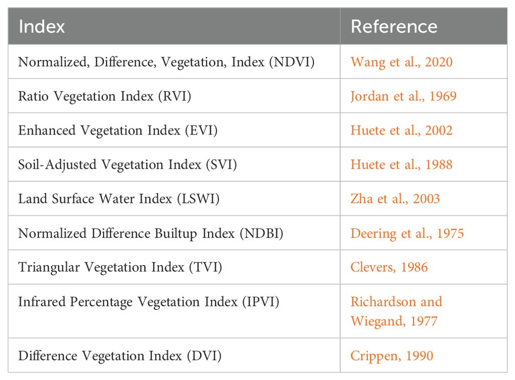
Table 1. List of different vegetative indices (VIs) that are used for yield predictions and field mapping.
The complex nonlinear relationships between input and response variables are successfully revealed by deep neural networks, in contrast to shallow networks with only one hidden layer. They also eliminate the time-consuming manual feature-crafting process (LeCun et al., 2015). For efficient training, they require more advanced technology and optimization techniques. The network’s convergence may be hampered by issues like vanishing or inflating gradients, even if enhancing the hidden layers may reduce classification or regression errors (He K et al., 2016). In order to estimate agricultural yield, Sobhana et al. (2022) devised an approach that combines geographic data with deep neural networks. Along with developing a user interface known as CROPUP, they developed a recommendation engine that uses deep learning techniques like XGBoost to suggest appropriate crops. When used, their methodology can increase crop yield and efficiency, with an accuracy of 99.3% in all seasons (Sobhana et al., 2022). In order to predict the yield of hybrid maize, Khaki and Wang (2019) suggested a deep learning method for crop yield prediction. This method used a deep neural network based on environmental and genotype data. With an RMSE of 12.81 kg/1000 m2 and a validation correlation coefficient of 0.814,34 the results show that this model outperforms other popular techniques, such as regression trees (RT), shallow neural networks (SNN), and Least Absolute Shrinkage and Selection Operator (Lasso).
CNNs are more efficient at locating important features in data than conventional feedforward neural networks. Crop mapping and yield prediction also make use of a 1D CNN applied along the temporal or spectral dimension. Multitemporal images can be effectively and efficiently classified using 1D CNN, as shown by Zhong et al. (2019) Using multitemporal Landsat EVI data, the authors classified summer crops by comparing the output of a 1D CNN and an RNN. The 1D CNN outperformed CNN-, RF-, and SVM-based techniques in the experiment in terms of accuracy and FI score. This experiment showed how 1D CNN may express temporal data for crop classification. This method’s drawback is that it ignores the spectral and spatial information seen in satellite imagery. For crop mapping, Zhou et al. (2018) employed object-based image analysis, a classification technique that is widely known for high-resolution pictures. The authors created segments from Sentinel-2 data using a segmentation method, then classified the segments’ mean spectral vector using a 1D CNN. Although this method captured spatial information by using the mean of the segments, it failed to describe the time relation, which would have increased accuracy.
Among the popular CNN variations for yield prediction are 2D-CNN, 3D-CNN, and YOLO. In particular, 3D-CNN is known as a spatiotemporal method, whereas 2D-CNN is frequently referred to as a spatial approach (Khaki et al., 2020). Yang et al. created a corn yield prediction model using a 2D-CNN deep learning algorithm. According to the study, 2D-CNN offers notable benefits in terms of feature extraction and categorization (Yang et al., 2021). Nevavuori et al. (2020) used time series and multi-temporal data in a spatial–temporal 3D-CNN architecture to forecast yield in the field. The prediction accuracy of the 3D-CNN model was higher than that of the other models. Nevavuori et al. (2019) developed a crop yield forecast model for wheat and barley using Convolutional Neural Networks, which were based on Normalized Difference Vegetation Index (NDVI) and RGB (a color model used for representing and creating colors) data collected from drones. The final results showed that the CNN model could provide a particular deep learning model for crops in Finland’s continental subarctic environment by estimating yields based on RGB photos in a reasonable and accurate manner.
RNNs are useful for a variety of applications, such as time series analysis, handwriting recognition, picture captioning, machine translation, natural language processing, and crop yield prediction (Archana and Kumar, 2023). Nevertheless, RNNs have a problem with vanishing or ballooning gradients, which makes it difficult to forecast long-term relationships. To overcome the vanishing gradient problem in RNNs, Long Short-Term Memory (LSTM) networks were created (Nevavuori et al., 2019). A rice yield prediction model was created by Wang et al. (2023) using an artificial neural network with Bidirectional Long Short-Term Memory (Bi-LSTM). With an average inaccuracy of 25 kg/m2, the results show that the Bi-LSTM prediction model does well in predicting rice production.
3 Machine learning techniques
The ability of machine learning algorithms to solve big non-linear problems on their own using datasets from several (perhaps related) sources is one of their key benefits. Ma et al. (2021) created a Bayesian Neural Network (BNN)-based maize yield prediction model at the county level. This model forecasts maize yields in atypical years brought on by major weather events with accuracy, in addition to accurately estimating maize yields in regular years. The prediction results’ average R2 is 0.77, offering a strong foundation for projecting intra-seasonal crop yields. Ren et al. (2023) developed an innovative hybrid strategy that combines deep learning methods with the WOFOST model to enhance yield predictions. By using tailored feature combinations for each growth stage, they conducted a comprehensive analysis that achieved impressive results: a Mean Relative Error (MRE) of 1.5, a Root Mean Square Error (RMSE) of 102.65 kg/ha, and an R-squared (R²) value of 0.98. This approach provides reliable analytical data for different growth phases and significantly improves the accuracy of yield forecasting, benefiting agricultural planning and decision-making. Chu and Yu (2020) employed another model for crop yield prediction by combining Back-Propagation Neural Networks (BPNNs) and Independently Recurrent Neural Networks (IndRNN).
Software libraries with pre-built structures designed for DL model implementation are known as deep-learning frameworks. In this approach, DL architectures have become easier to implement and more accessible. Convolutional architectures for PyTorch (Paszke et al., 2019), CNTK (Seide and Agarwal, 2016), and MatConvNet (Vedaldi and Lenc, 2015) are the most widely used DL frameworks. With the help of these frameworks’ powerful GPU backend, networks with billions of parameters can be trained. A machine learning library called Scikit-learn (2022) also incorporates deep neural networks.
To further expand the data and make sure the model was independent of rotation and flips, data-augmentation techniques like rotation and flips were also included in the crop-mapping (Du et al., 2019) and yield-prediction investigations. To overcome the lack of training data, a few crop-mapping research employed weakly supervised learning and the domain-adaptation technique (Wang et al., 2020). Therefore, further refinement of deep learning model architectures and algorithms will be essential developments in agricultural production forecasting.
4 Remote sensing techniques
Remote sensing photographs provide timely, consistent, and cost-effective data for identifying and tracking the features of the earth’s surface (Justice et al., 2002). Geological reconnaissance, environmental monitoring, and agricultural productivity are just a few key sectors where this technology proves invaluable.
Predicting agricultural yields before harvest is crucial for planning and deciding on different policies. Conventional approaches are expensive, subjective, and time-consuming. A number of issues also influence the development of empirical models that use meteorological data. Information on electromagnetic radiation was gathered using a wide variety of sensors, including satellite images, aerial photogrammetry, multispectral scanners in the air, high and low spectral and spatial resolution, and field-based spectrometer analysis (Jennewein et al., 2024). Two types of fluorescence are employed to evaluate the physiological conditions of vegetation cover and stress levels (Belasque et al., 2008). Between 400 and 600 nm is the wavelength for blue-green fluorescence, while between 650 and 800 nm is the wavelength for chlorophyll fluorescence. They also found that spectroscopic analysis can be utilized to evaluate in-plant diseases, environmental stress levels, and nutritional deficiencies.
Important characteristics that are used in a variety of agricultural applications are vegetation indices (VIs). For instance, there are various uses for the normalized difference vegetation index (NDVI) in crop monitoring (Karmakar et al., 2024). Leaf nitrogen content can be estimated with the aid of the Angular Insensitivity Vegetation Index (AIVI) (He et al., 2016). The Photochemical Reflectance Index (PRI) can be used to analyze the severity of plant diseases (Huang et al., 2008). Using linear non-linear procedures, VIs are produced by combining remotely sensed data at various wavelengths, usually in the red and infrared ranges (Bhunia et al., 2021). In order to enhance early warning systems, these measures have been used to evaluate crop growth status and the effects of agroclimatic conditions, pests and diseases, water stress, and management techniques on crop development.
4.1 Field sensors
The electromagnetic spectrum includes several key wavelengths that are particularly effective for fluorescence imaging. These include the green (520–550 nm), blue (440 nm), red (690 nm), far-red (740 nm), and near-infrared (800 nm) regions. Utilizing these specific wavelengths can enhance the effectiveness of fluorescence imaging techniques (Coops et al., 2003). Lenk et al. (2007) demonstrated the use of multispectral data and applications to improve imaging techniques by discriminating fruit quality, photosynthetic activities, tissue structures, and plant disease symptoms. These techniques are an overview since they provide three-dimensional spectral information in the form of pictures and incorporate spectral characteristics from multiple areas.
The use of hyperspectral images in precision farming applications has grown significantly. According to Zaman et al. (2011) remote sensing data provides an easy and affordable way to differentiate between different land uses, such as horticultural crops or orchards, and fruit trees. By evaluating the landscape’s intricate monitoring characteristics, multi-temporal satellite imaging data offer a means of identifying notable changes in land cover and measuring the rates of change. The phases of crop growth and agricultural phenology were not clearly defined and are often hard to explain because of variations in crop varieties, plant densities, and crop cultivation techniques.
However, using spectral derivatives, continuous removal transformations, and continuous wavelet transformations, hyperspectral data are more sophisticated in detecting leaf biochemical constituents or recognizing aberrant spectral features impacted by pests and diseases. When leaf characteristics like pigment concentration, other chemical components, or pest or disease problems vary, the scattering from the leaf reacts differently at different wavelengths (Knyazikhin et al., 2013). In addition to the PRI for identifying wheat yellow rust (Huang et al., 2007) and the chlorophyll absorption ratio index (CARI) for identifying wheat powdery mildew (Zhang et al., 2012), a blueshift was noted in the red-edge peak in the first derivative of rice plant spectral curves afflicted by rice leaf folder (Huang et al., 2012). However, the implementation of satellite hyperspectral sensors in operational activities is not practical due to their limited swaths and low temporal resolution. As a result, operational crop monitoring rarely includes the detection of nitrogen stress or the identification of crop diseases and pests.
4.2 Satellite imagery
At the regional and local levels, agricultural production has been evaluated and estimated using satellite data from Landsat, SPOT, WorldView, and Sentinel-2, which have a medium spatial resolution ranging from 10 to 100 meters (Mueller et al., 2012). Crop yields and biomass have been assessed using images from Landsat 5 TM and SPOT 4 (Noureldin et al., 2013). The issue of small areas was resolved and excellent crop yield accuracy was established using Quickbird, SPOT5, and Landsat satellite photos (Yang et al., 2009). Patel et al. (1991) established an empirical correlation to estimate agricultural output using the ratio of NIR and R spectral bands generated from IRS LISS data. Shirsath et al. (2020) created crop yield maps after conducting a regional study on crop yield using the Enhanced Vegetation Index obtained from MODIES data.
4.3 Aerial photography
Airborne multispectral sensors generate high-resolution images that feature accurate spatial resolutions and a wide range of spectral bands. Recent studies by Torresan et al. (2016) and Manfreda et al. (2018) highlight the growing recognition within the ecological research community of aerial photography using Unmanned Aerial Vehicles (UAVs). This innovative technology is proving to be an invaluable tool for effectively monitoring vegetation and ecosystems, opening up new possibilities for ecological assessments and management.
It is possible to quantify spectral reflectance in the lab as well as in the field. To evaluate crop production, a range of ground optical sensors, including spectrometers and high resolution hyperspectral digital multispectral sensors, have been developed to gather reflectance data in different spectrum regions (Ahamed et al., 2011). Numerous spectral bands collected spanning the electromagnetic spectrum (350–2500 nm) are available using field spectroscopy, a form of ground-based remote sensing (Numata et al., 2008). Spectroscopic data at the ground and leaf level in the visible and infrared regions of the electromagnetic spectrum are supported by the notion that light interacts with the plant and that a green leaf’s reflectance properties play a role. Multidate optical (visible and near-infrared) remote sensing data and multidate microwave SAR (Synthetic Aperture Radar) satellite data are utilized for wheat and other crops (Defourny et al., 2019). Crop residues and intercrops can be identified using SAR time-series. Additionally, it can be used to find crop residues and intercrops.
In a recent study, crop management is improved to attain the best possible production in terms of both quantity and quality by using remote sensing to display the spatial variance in crop growth of wheat (Rebouh et al., 2023b). In 2019, Sentinel-2, which has a 10 m resolution, was utilized to track changes in wheat growth under various management techniques and the findings demonstrated that Green Chlorophyll Index performs best in forecasting crop yield.
5 Crop yield prediction study using performance evaluation metrics
An important part of estimating is comparing model outputs to real data. In order to effectively evaluate model performance and distinguish between various learning models, it is important to utilize appropriate evaluation metrics (Elavarasan et al., 2020). Key performance indicators for regression models, such as the coefficient of determination (R-squared), mean absolute error (MAE), mean squared error (MSE), root mean square error (RMSE), and mean absolute percentage error (MAPE), play a vital role in providing a comprehensive assessment of a model’s accuracy and reliability. The Mean Absolute Error (MAE) serves as a valuable tool for measuring the average significance of errors in a set of forecasts, as it calculates the arithmetic mean of the absolute differences between predicted and actual observations (Ali et al., 2018). Similarly, the Mean Squared Error (MSE) provides insights into the performance of the estimator by assessing how closely the regression line aligns with the data points (Elavarasan et al., 2020). To enhance the evaluation of model performance and facilitate meaningful comparisons between different learning models, it is crucial to utilize a range of evaluation metrics. Important performance indicators for regression models include the coefficient of determination (R-squared), Mean Absolute Error (MAE), Mean Squared Error (MSE), Root Mean Squared Error (RMSE), and Mean Absolute Percentage Error (MAPE).
The Root Mean Square Error (RMSE) provides valuable insight into the standard deviation of the residuals, illustrating how closely the data points align with the best fit line (Chakrabarty et al., 2021). This helps pinpoint areas for improvement in our model. Furthermore, the Coefficient of Determination (R-squared) offers a clear measure of how well our regression model captures the data, demonstrating that developed framework outperforms the baseline framework (Pant et al., 2021). Lastly, the Mean Absolute Percentage Error (MAPE) allows us to calculate the average percentage errors, showcasing the degree to which the forecasts differ from actual outcomes (Elavarasan et al., 2020). For classification difficulties, classification accuracy is still the most popular and useful metric.
6 Challenges and limitations
6.1 Geographical limitations
We must consider geographic differences because farming practices, climate, and crop types vary by location. When forecasting crops for different regions or countries, it’s essential to combine data and recognize these differences. Collecting accurate data on crop growth, soil, and climate can be challenging. High-quality data is crucial for deep learning, but issues like noise, missing information, or poor quality can reduce the model’s effectiveness. Soil nutrients, pests, diseases, and climate impact crop yields, but their complex interactions complicate accurate predictions (Figure 2). Climate change and natural disasters create uncertainty, making long-term projections difficult. Current models often overlook key factors and have limitations that need improvement.
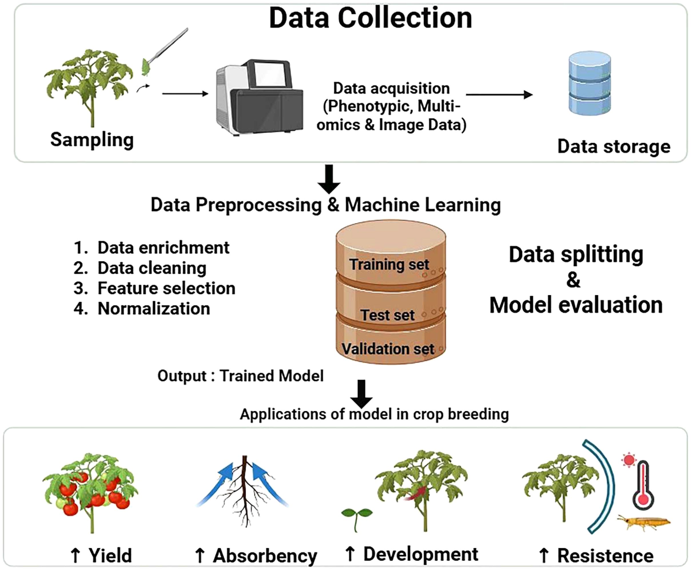
Figure 2. Flowchart of the steps for data collection and analysis for AI and ML in crop yield prediction.
6.2 Scalability and accessibility of technology
Deep learning (DL) models can be highly effective for crop prediction, but they often require significant training time, especially with multiple layers. Performance may vary, and the most complex models do not always yield the best user experience. To select the right crop prediction model, it’s important to analyze data conditions, prediction needs, and model characteristics. Comparing and evaluating different models will help identify the best fit. Additionally, consider factors like interpretability, computational efficiency, data requirements, and practical application to enhance your selection process. The difficulty lies in figuring out how to make the working model more accurate by training it on a larger dataset, evaluating it to see how well it performs, and figuring out how micro-topological changes impact crop yield prediction (Bramon et al., 2011). Examining the model’s substantial practical implications for giving farmers, growers, and policymakers accurate information on crop yield presents another difficulty.
Advancements in agricultural production prediction are poised to transform the industry through the ongoing refinement of deep learning models and algorithms. By leveraging big data to analyze soil, climate, and plant growth, these models will reveal valuable insights and patterns, enhancing crop yield management and forecasting accuracy. With added layers, complex connectivity, and strategic parameter tuning, these models will effectively grasp intricate data relationships. This empowers farmers to maximize yields while minimizing resource use. Ultimately, improvements in predictive modeling will boost the sustainability of agriculture, addressing global food security challenges and paving the way for innovative advancements in agricultural forecasting (Gamage et al., 2024).
Satellite data remains a highly effective method for surveying extensive areas and monitoring agricultural changes on both regional and national scales. By leveraging satellite imagery, we can gain valuable insights for practical applications. However, it’s essential to have a strong foundation in technical knowledge and skills to effectively process this data and maximize its potential benefits. To extract relevant information for agricultural monitoring, the vast amount of data from many sensors necessitates effective processing and analysis techniques (Wu et al., 2022). Due to variations in spectral range, data format, and geographical and temporal resolution, integrating data from many sensors can be difficult. This may result in challenges with data fusion and processing, which may impact crop monitoring’s precision and dependability (Joshi et al., 2023). A number of variables, including sensor calibration, atmospheric conditions, and data processing techniques, can affect the consistency and quality of remote sensing data from various sources. Additionally, this may make data fusion and analysis challenging (Omia et al., 2023). Furthermore, the difficulty is in creating a strategy with possible variables that will probably work well for all crops or certain crop types.
6.3 Data privacy and security concerns
Another big obstacle farmers face is negotiating proper data rights in agriculture with Agriculture Technology Providers (ATPs). It implies that to ensure a long-lasting and mutually beneficial partnership between farmers and ATPs, procedures for calculating rewards, protecting rights, and conducting audits are necessary (Yu et al., 2025). Clearer laws, farmers’ involvement in contract talks, and the creation of marketplaces for digital commodities like data and products derived from it are some possible remedies. It does, however, recognize that these solutions are intricate and that their success depends on stakeholder cooperation, regulation, and education (Bryan and Richey, 2020). Concerns about data ownership, sharing, and access rights must be addressed by farmers and IT companies in order to safeguard sensitive data, foster trust, and ensure compliance with data protection regulations (Shawe and McAndrew, 2023).
6.4 Energy efficiency concerns
Big data, however, necessitates datacenters with upgraded infrastructure that can handle and analyze data with greater responsibility. A key consideration in the planning and construction of contemporary datacenters is power usage. The overall power used by computing systems is barely declining, despite a continuous increase in the performance per watt ratio (Al-Fares et al., 2008). Greenhouse gas emissions from this have a significant effect on the environment as well. Therefore, reducing energy use and operating expenses is a critical consideration as the datacenter’s size grows. The servers, storage, and connective network infrastructure of future datacenters should be able to manage big data applications with minimal energy consumption.
6.5 New developments and possible inventions
In order to enhance overall performance, more models, frames, or intricate structures are anticipated to take use of the spectral and temporal dimensions of satellite data and combine additional elements that have been extracted using different techniques. Therefore, the application of both spatial (such as field-measured data) and historical (such as crop rotation histories) data to deep learning methods, along with the incorporation of multisensor data, satellite-derived crop phenology, and cropping practice information (Adrian et al., 2021; Xu et al., 2021), constitute significant future directions that can result in cloud services to ensure globally accurate crop mapping and area estimation results (Kussul et al., 2017). To enhance learning performance and reduce dependence on in situ data, it is essential to further develop transfer learning techniques. These techniques integrate crop phenology with existing knowledge of agricultural practices. By using a model that has been pretrained on a large dataset, we can more effectively adapt it to improve prediction accuracy for the specific target dataset. The geographical resolution and fragmentation of the agricultural environment determine resolution bias, which is inevitable (Waldner and Defourny, 2017). Resolution bias can arise from pixels covering small ponds, canals, and other noncrop objects, especially in mountainous regions. Therefore, by assessing the effects of the combination of arable land pixels, an unbiased estimator must be used to adapt the actual crop area in a given location (Olofsson et al., 2014).
7 Conclusions
Crop yield and agricultural output can be significantly enhanced by addressing several key factors. These include optimizing climate conditions, improving soil properties, ensuring proper crop nutrient management, and maximizing crop canopy volume and biomass. Additionally, maintaining adequate water content while effectively managing diseases, weeds, and insects, as well as selecting the right crop cultivars and varieties, can further contribute to successful agricultural production. According to the current review, deep learning models typically produce predictions that are more accurate than those made by conventional machine learning models. But it’s also critical to test models with different feature counts and levels of complexity in order to identify the top-performing model. Lastly, we also discussed about the possible challenges in estimating agricultural yields using these technologies. Additionally, a fast, cost-effective, and efficient way to track and evaluate crop vigor and estimate crop production is using remote sensing. A highly effective and realistic approach to yield prediction could involve employing direct statistical and empirical models that utilize minimal inputs. By integrating data collected from remote sensing sensors with measured factors that reflect the biochemical and biophysical properties of crops, we can enhance the input components of these models. This method has the potential to improve prediction accuracy and efficiency in yield forecasting. While satellite data and processing capabilities are now advanced, many organizations and agencies still use satellite-derived crop monitoring methods to inform policymakers about crop production and food security issues. Prediction accuracy is measured by common performance metrics such as RMSE, MSE, MAE, and MAPE. However, these approaches have not yet achieved near-real-time, accurate, and quantitative information about crops. Furthermore, concentrating on modeling prediction uncertainty can help with efficient estimation of prediction result uncertainty, enhancing the predictability and interpretability of forecasts.
Author contributions
SS: Conceptualization, Data curation, Writing – original draft, Writing – review & editing. OK: Writing – original draft, Writing – review & editing. AU: Writing – original draft, Writing – review & editing. NR: Writing – original draft, Writing – review & editing.
Funding
The author(s) declare that financial support was received for the research and/or publication of this article. This paper has been supported by the RUDNUniversity Strategic Academic Leadership Program.
Acknowledgments
Authors acknowledge their respective department and institutions for providing support and facilities.
Conflict of interest
The authors declare that the research was conducted in the absence of any commercial or financial relationships that could be construed as a potential conflict of interest.
Generative AI statement
The author(s) declare that no Generative AI was used in the creation of this manuscript.
Publisher’s note
All claims expressed in this article are solely those of the authors and do not necessarily represent those of their affiliated organizations, or those of the publisher, the editors and the reviewers. Any product that may be evaluated in this article, or claim that may be made by its manufacturer, is not guaranteed or endorsed by the publisher.
References
Adrian J., Sagan V., and Maimaitijiang M. (2021). Sentinel SAR-optical fusion for crop type mapping using deep learning and Google Earth Engine. ISPRS J. Photogramm. Remote Sens. 175, 215–235. doi: 10.1016/j.isprsjprs.2021.02.018
Ahamed T., Tian L., Zhang Y., and Ting K. C. (2011). A review of remote sensing methods for biomass feedstock production. Biomass Bioen. 35, 2455–2469. doi: 10.1016/j.biombioe.2011.02.028
Al-Fares M., Loukissas A., and Vahdat A. (2008). “A scalable, commodity datacenter network architecture,” in Proceedings of the ACM SIGCOMM Conference on Data Communication. 63–74.
Ali M., Deo R. C., Downs N. J., and Maraseni T. (2018). Multi-stage committee based extreme learning machine model incorporating the influence of climate parameters and seasonality on drought forecasting. Comput. Electron. Agric. 152, 149–165. doi: 10.1016/j.compag.2018.07.013
Archana S. and Kumar S. P. (2023). A survey on deep learning based crop yield prediction. Nat. Environ. pollut. Technol. 22, 579–592. doi: 10.46488/NEPT.2023.v22i02.004
Belasque L., Gasparoto M. C. G., and Marcassa L. G. (2008). Detection of mechanical and disease stresses in citrus plants by fluorescence spectroscopy. Appl. Opt. 47, 1922–1926. doi: 10.1364/AO.47.001922
Bhunia G. S., Chatterjee U., Kashyap A., and Shit P. K. (2021). Land reclamation and restoration strategies for sustainable development: Geospatial technology based approach (Elsevier: Netherlands).
Bramon R., Boada I., Bardera A., Rodriguez J., Feixas M., Puig J., et al. (2011). Multimodal data fusion based on mutual in-formation. IEEE Trans. Vis. Comput. Graph. 18, 1574–1587. doi: 10.1109/TVCG.2011.280
Bryan S. and Richey L. (2020). Data rights and privacy in agriculture: A global perspective. J. Data Pri. Ethics 5, 112–123.
Capa-Morocho M., Ines A. V. M., Baethgen W. E., Rodríguez-Fonseca B., Han E., and Ruiz-Ramos M. (2016). Crop yield outlooks in the Iberian Peninsula: Connecting seasonal climate forecasts with crop simulation models. Agric. Syst. 149, 75–87. doi: 10.1016/j.agsy.2016.08.008
Case-Cohen A. L. (2018). Understanding the Soil Health Knowledge of Farmers in the Yakima Valley, Evergreen State College.
Chakrabarty A., Mansoor N., Uddin M. I., Al-Adaileh M. H., Alsharif N., and Alsaade F. W. (2021). Prediction approaches for smart cultivation: a comparative study. Complexity 2021. doi: 10.1155/2021/5534379
Chu Z. and Yu J. (2020). An end-to-end model for rice yield prediction using deep learning fusion. Comput. Electron. Agric. 174. doi: 10.1016/j.compag.2020.105471
Coops N. C., Stone C., Culvenor D. S., Chisholm L. A., and Merton R. N. (2003). Chlorophyll content in eucalypt vegetation at the leaf and canopy scales as derived from high resolution spectral data. Tree Phys. 23, 23–31. doi: 10.1093/treephys/23.1.23
Clevers J. P. W. (1986) The application of a vegetation index in correcting the infrared reflectance for soil background. International Archives of Photogrammetry and Remote Sensing, Balkema, Rotterdam, Boston 26(1), 221–226.
Crippen R. E. (1990). Calculating the vegetation index faster.Remote Sensing of Environment 34(1), 71–73.
Deenng D. W., Haas R. H., and Schell J. A. (1975), Measuring forage productton of gramng urnts from Landsat MSS data. Proceedings of the Tenth Internatmnal Symposium on Remote Sensing of Environment, ERIM, Ann Arbor, MI, 1169–1178.
Defourny P., Bontemps S., Bellemans N., Cara C., Dedieu G., Guzzonato E., et al. (2019). Near real-time agriculture monitoring at national scale at parcel resolution: Performance assessment of the Sen2-Agri automated system in various cropping systems around the world. Rem. Sens. Env. 221, 551–568. doi: 10.1016/j.rse.2018.11.007
de Freitas Cunha R. L. and Silva B. (2020). “Estimating crop yields with remote sensing and deep learning,” in Proceedings of the 2020 IEEE Latin American GRSS & ISPRS Remote Sensing Conference (LAGIRS), Santiago, Chile. 273–278.
Du Z., Yang J., Ou C., and Zhang T. (2019). Smallholder crop area mapped with a semantic segmentation deep learning method. Remote Sens. 11, 888. doi: 10.3390/rs11070888
Elavarasan D., Vincent D. R., Srinivasan K., and Chang C.-Y. (2020). A hybrid CFS filter and RF-RFE wrapper-based feature extraction for enhanced agricultural crop yield prediction modeling. Agriculture 10, 400. doi: 10.3390/agriculture10090400
El Behairy R. A., Arwash H. M. E., El Baroudy A. A., Ibrahim M. M., Mohamed E. S., Rebouh N. Y., et al. (2023). Artificial intelligence integrated GIS for land suitability assessment of wheat crop growth in arid zones to sustain food security. Agronomy 13, 1281. doi: 10.3390/agronomy13051281
Environment and Climate Change Canada (ECCC) (2021). National inventory report 1990–2019: greenhouse gas sources and sinks in Canada. Available online at: https://publications.gc.ca/site/eng/9.506002/publication.html (Accessed December 19, 2022).
Gamage A., Gangahagedara R., Subasinghe S., Gamage J., Guruge C., Senaratne S., et al (2017). Sugarcane yield prediction in Brazil using NDVI time series and neural networks ensemble. Int. J. Remote Sens. 38, 4631–4644. doi: 10.1080/01431161.2017.1325531
Gamage A., Gangahagedara R., Subasinghe S., et al. (2024). Advancing sustainability: The impact of emerging technologies in agriculture. Curr. Plant Biol. 40, 100420. doi: 10.1016/j.cpb.2024.100420
Gawande V., Saikanth D. R. K., Sumithra B. S., Swamy G. N., Chowdhury M., and Singh B. V. (2023). Potential of precision farming technologies for eco-friendly agriculture. Int. J. Plant Soil Sci. 35, 101–112. doi: 10.9734/ijpss/2023/v35i193528
Haghverdi A., Washington-Allen R. A., and Leib B. G. (2018). Prediction of cotton lint yield from phenology of crop indices using artificial neural networks. Comput. Electron. Agric. 152, 186–197. doi: 10.1016/j.compag.2018.07.021
He K., Zhang X., Ren S., and Sun J. (2016). “Deep residual learning for image recognition,” in Proceedings of the IEEE Conference on Computer Vision and Pattern Recognition, Las Vegas, NV, USA. 770–778.
Huang W., Lamb D. W., Niu Z., Zhang Y., Liu L., Wang J., et al. (2007). Identification of yellow rust in wheat using in-situ spectral reflectance measurements and airborne hyperspectral imaging. Precision Agric 8, 187–197.
Huang W., Lamb D. W., Niu Z., Zhang Y., Liu L., and Wang J. (2007). Identification of yellow rust in wheat using in-situ spectral reflectance measurements and airborne hyperspectral imaging. Precis. Agric. 8, 187–197. doi: 10.1007/s11119-007-9038-9
Huang J., Liao H., Zhu Y., Sun J., Sun Q., and Liu X. (2012). Hyperspectral detection of rice damaged by rice leaf folder (Cnaphalocrocis medinalis). Comput. Electron. Agric. 82, 100–107. doi: 10.1016/j.compag.2012.01.002
Huete A., Didan K., Miura T., Rodriguez E. P., Gao X., and Ferreira L. G.. (2002). Overview of the radiometric and biophysical performance of the MODIS vegetation indices. Remote Sensing of Environment, 83, 195–213
Jennewein J. S., Hively W., Lamb B. T., Daughtry C. S. T., Thapa R., Thieme A., et al. (2024). Spaceborne imaging spectroscopy enables carbon trait estimation in cover crop and cash crop residues. Precis. Agric. 25, 2165–2197. doi: 10.1007/s11119-024-10159-4
Jones J. W. (2003). The DSSAT cropping system model. Eur. J. Agron. 18, 235–265. doi: 10.1016/S1161-0301(02)00107-7
Jordan C. F. (1969). Derivation of leaf area index from quality of light on the forest floor. Ecology, 50, 663–666.
Joshi A., Pradhan B., Gite S., and Chakraborty S. (2023). Remote-sensing data and deep-learning techniques in crop mapping and yield prediction: A systematic review. Remote Sens. 15. doi: 10.3390/rs15082014
Justice C. O., Townshend J. R. G., Vermata E. F., Masuoka E., Wolfe R. E., Saleons N., et al. (2002). An overview of MODIS Land data processing and product status. Remote Sens. Environ. 83, 3–15. doi: 10.1016/S0034-4257(02)00084-6
Karmakar P., Teng S. W., Murshed M., Pang S., Li Y., and Lin H. (2024). Crop monitoring by multimodal remote sensing: A review. Rem. Sens. App.: Soc Env. 33, 101093. doi: 10.1016/j.rsase.2023.101093
Karunathilake E. M. B. M., Le A. T., Heo S., Chung Y. S., and Mansoor S. (2023). The path to smart farming: Innovations and opportunities in precision agriculture. Agriculture 13, 1593. doi: 10.3390/agriculture13081593
Khaki S. and Wang L. (2019). Crop yield prediction using deep neural networks. Front. Plant Sci. 2019, 10. doi: 10.3389/fpls.2019.00621
Khaki S., Wang L., and Archontoulis S. V. (2020). A CNN-RNN framework for crop yield prediction. Front. Plant Sci. 10, 1750. doi: 10.3389/fpls.2019.01750
Knyazikhin Y., Schull M. A., Stenberg P., Mõttus M., Rautiainen M., Yang Y., et al. (2013). Hyperspectral remote sensing of foliar nitrogen content. Proc. Natl. Acad. Sci. U.S.A. 110, E185–E192. doi: 10.1073/pnas.1210196109
Kussul N., Lavreniuk M., Skakun S., and Shelestov A. (2017). Deep learning classification of land cover and crop types using remote sensing data. IEEE Geosci. Remote Sens. Lett. 14, 778–782. doi: 10.1109/LGRS.2017.2681128
Lecerf R., Ceglar A., López-Lozano R., van der Velde M., and Baruth B. (2019). Assessing the information in crop model and meteorological indicators to forecast crop yield over Europe. Agric. Syst. 168, 191–202. doi: 10.1016/j.agsy.2018.03.002
Lenk S., Chaerle L., Pfundel E. E., Langsdorf G., Hagenbeek D., Lichtenthaler H. K., et al. (2007). Multispectral fluorescence and reflectance imaging at the leaf level and its possible applications. J. Exp. Bot. 58, 807–814. doi: 10.1093/jxb/erl207
Liakos K. G., Busato P., Moshou D., Pearson S., and Bochtis D. (2018). Machine learning in agriculture: A review. Sensors 18, 2674. doi: 10.3390/s18082674
Linaza M. T., Posada J., Bund J., Eisert P., Quartulli M., Döllner J., et al. (2021). Data-driven Artificial Intelligence applications for sustainable precision agriculture. Agronomy 11, 1227. doi: 10.3390/agronomy11061227
Lobell D., Thau D., Seifert C., Engle E., and Little B. (2015). A scalable satellite-based crop yield mapper. Rem. Sens. Env. 164. doi: 10.1016/j.rse.2015.04.021
Ma Y., Zhang Z., Kang Y., and Özdo¢gan M. (2021). Corn yield prediction and uncertainty analysis based on remotely sensed variables using a Bayesian neural network approach. Remote Sens. Environ. 259, 112408. doi: 10.1016/j.rse.2021.112408
Manfreda S., McCabe M., Miller P., Lucas R., Madrigal V. P., Mallinis G., et al. (2018). On the use of unmanned aerial systems for environmental monitoring. Remote Sens. 10, 641. doi: 10.3390/rs10040641
Mueller N. D., Gerber J. S., Johnston M., Ray D. K., Ramankutty N., and Foley J. A. (2012). Closing yield gaps through nutrient and water management. Nature 490, 254–257. doi: 10.1038/nature11420
Nevavuori P., Narra N., Linna P., and Lipping T. (2020). Crop yield prediction using multitemporal UAV data and spatio-temporal deep learning models. Remote Sens. 12, 4000. doi: 10.3390/rs12234000
Nevavuori P., Narra N., and Lipping T. (2019). Crop yield prediction with deep convolutional neural networks. Comput. Electron. Agric. 163, 104859. doi: 10.1016/j.compag.2019.104859
Nguyen G., Dlugolinsky S., Bobák M., Tran V., López García Á., Heredia I., et al. (2019). Machine learning and deep learning frameworks and libraries for large-scale data mining: A survey. Artif. Intell. Rev. 52, 77–124. doi: 10.1007/s10462-018-09679-z
Noureldin N. A., Aboelghar M. A., Saudy H. S., and Ali A. M. (2013). Rice yield forecasting models using satellite imagery in Egypt. Egyptian J. Rem. Sens. Space Sci. 16, 125–131. doi: 10.1016/j.ejrs.2013.04.005
Numata I., Roberts D. A., Chadwick O.a., Schimel J. P., Galvão L. S., and Soares J. V. (2008). Evaluation of hyperspectral data for pasture estimate in the Brazilian Amazon using field imaging spectrometers. Remote Sens. Env. 112, 1569–1583. doi: 10.1016/j.rse.2007.08.014
Olofsson P., Foody G. M., Herold M., Stehman S. V., Woodcock C. E., Michael A., et al. (2014). Good practices for estimating area and assessing accuracy of land change. Remote Sens. Environ. 148, 42–57. doi: 10.1016/j.rse.2014.02.015
Omia E., Bae H., Park E., Kim M. S., Baek I., Kabenge I., et al. (2023). Remote sensing in field crop monitoring: A comprehensive review of sensor systems, data analyses and recent advances. Remote Sens. 15. doi: 10.3390/rs15020354
Pant J., Pant R. P., Kumar M., Pratap D., and Pant H. (2021). Materials Today: proceedings Analysis of agricultural crop yield prediction using statistical techniques of machine learning. Mater. Today: Proc. 46, 1–5.
Paszke A., Gross S., Massa F., Lerer A., Bradbury J., Chanan G., et al. (2019). and antiga, L. Pytorch: an imperative style, high-performance deep learning library. Adv. Neural Inf. Process Syst. 32, 8026–8037. doi: 10.48550/arXiv.1912.01703
Patel N. K., Ravi N., and Navalagund R. R. (1991). Estimation of rice yield using IRS-1A digital data in costal tract of Orissa. Int. J. Remote Sens. 12, 2259–2266. doi: 10.1080/01431169108955256
Rebouh N. Y., Khugaev C. V., Utkina A. O., Isaev K. V., Mohamed E. S., and Kucher D. E. (2023a). Contribution of eco-friendly agricultural practices in improving and stabilizing wheat crop yield: A review. Agronomy 13, 2400. doi: 10.3390/agronomy13092400
Rebouh N. Y., Mohamed E. S., Polityko P. M., Dokukin P. A., Kucher D. E., Latati M., et al. (2023b). Towards improving the precision agriculture management of the wheat crop using remote sensing: a case study in Central Non-Black Earth region of Russia. Egypt. J. Remote Sens. Space Sci. 26, 505–517. doi: 10.1016/j.ejrs.2023.06.007
Ren Y., Li Q., Du X., Zhang Y., Wang H., Shi G., et al. (2023). Analysis of corn yield prediction potential at various growth phases using a process-based model and deep learning. Plants 12, 446. doi: 10.3390/plants12030446
Richardson A. J. and Wiegand C. (1977). Distinguishing Vegetation from Soil Background Information. Photogrammetric Engineering and Remote Sensing, 43, 1541–1552.
Russello H. “Convolutional Neural Networks for Crop Yield Prediction Using Satellite Images,” Master Thesis, University of Amsterdam, 2018.
Scikit-Learn (2022). Available online at: https://scikit-learn.org/stable/index.html (Accessed March 1, 2022).
Seide F. and Agarwal A. (2016). “Cntk: microsoft’s open-source deep-learning toolkit,” in Proceedings of the 22nd ACM SIGKDD International Conference on Knowledge Discovery and Data Mining, New York, NY, USA. 2135.
Sharma S., Rai S., and Krishnan N. C. (2020). Wheat crop yield prediction using deep LSTM model. arXiv. doi: 10.48550/arXiv.2011.01498
Shawe R. and McAndrew I. R. (2023). Increasing threats to United States of America infrastructure based on cyber-attacks. J. Software Eng. Appl. 16, 530–547. doi: 10.4236/jsea.2023.1610027
Shirsath P. B., Sehgal V. K., and Aggarwal P. K. (2020). Downscaling regional crop yields to local scale using remote sensing. Agric. (Switzerland) 10, 1–14. doi: 10.3390/agriculture10030058
Sobhana M., Chowdary S. C., Indira D. N. V. S. L.S., and Kumar K. K. (2022). CROPUP—A crop yield prediction and recommendation system with geographical data using DNN and XGBoost. Int. J. Recent Innov. Trends Comput. Commun. 10, 53–62. doi: 10.17762/ijritcc.v10i11.5780
Tian H., Wang P., Tansey K., Han D., Zhang J., Zhang S., et al. (2021). A deep learning framework under attention mechanism for wheat yield estimation using remotely sensed indices in the Guanzhong Plain, Pr China. Int. J. Appl. Earth Obs. Geoinf. 102, 102375. doi: 10.1016/j.jag.2021.102375
Tian T., Zhong C., Lin X., Wei Z., and Hakonarson H. (2023). Complex hierarchical structures in single-cell genomics data unveiled by deep hyperbolic manifold learning. Genome Res. 33, 232–246. doi: 10.1101/gr.277068.122
Torresan C., Berton A., Carotenuto F., Di Gennaro S. F., Gioli B., Matese A., et al. (2016). Forestry applications of UAVs in Europe: a review. International Journal of Remote Sensing, 38 (8–10), 2427–2447.
United Nations (2024). “United Nations, Department of Economic and Social Affairs, Population Division,” in World Population Prospects 2024, Online Edition.
Vedaldi A. and Lenc K. (2015). “Matconvnet: convolutional neural networks for matlab,” in Proceedings of the 23rd ACM international conference on Multimedia, Brisbane, Australia. 689–692.
Waldner F. and Defourny P. (2017). Where can pixel counting area estimates meet user-defined accuracy requirements? Int. J. Appl. Earth Obs. Geoinf. 60, 1–10. doi: 10.1016/j.jag.2017.03.014
Wang S., Chen W., Xie S. M., Azzari G., and Lobell D. B. (2020). Weakly supervised deep learning for segmentation of remote sensing imagery. Remote Sens. 12, 207. doi: 10.3390/rs12020207
Wang Y., Zhao W., Tang X., Liu Y., Tang H., Guo J., et al. (2023). “Plasma rice yield prediction based on Bi-LSTM model,” in Proceedings of the Second International Conference on Electronic Information Engineering, Big Data, and Computer Technology (EIBDCT 2023), Xishuangbanna, China, Vol. 68.
Weiss M., Jacob F., and Duveiller G.. Remote sensing for agricultural applications: A meta-review. (2019). Remote Sens. Env. 236.
World Health Organization (WHO) (2023). Fact sheets: climate change and health. Available online at: https://www.who.int/news-room/fact-sheets/detail/climate-change-and-health (Accessed October 12, 2023).
Wu B., Zhang M., Zeng H., Tian F., Potgieter A. B., Qin X., et al. (2022). Challenges and opportunities in remote sensing-based crop monitoring: a review. Natl. Sci. Rev. 10, nwac290. doi: 10.1093/nsr/nwac290
Xu J., Yang J., Xiong X., Li H., Huang J., Ting K. C., et al. (2021). Towards interpreting multi-temporal deep learning models in crop mapping. Remote Sens. Environ. 264, 112599. doi: 10.1016/j.rse.2021.112599
Yang C., Everitt J. H., and Bradford J. M. (2009). Evaluating high resolution SPOT 5 satellite imagery to estimate crop yield. Precis. Agric. 10, 292–303. doi: 10.1007/s11119-009-9120-6
Yang W., Nigon T., Hao Z., Paiao G. D., Fernández F. G., Mulla D., et al. (2021). Estimation of corn yield based on hyperspectral imagery and convolutional neural network. Comp. Electr. Agric. 184, 106092. doi: 10.1016/j.compag.2021.106092
Yang X., Yang H., Zhang F., Fan X., Ye Q., and Feng Z. (2019). A random-weighted plane Gaussian artificial neural network. Neural Comput. Applic. 31, 8681–8692. doi: 10.1007/s00521-019-04457-6
Yu Z., Hou E., Pompeo J., Huffaker R., Wang M., Zhao Y., et al. (2025). Agriculture technology providers’ perspectives of data rights and obligations in agriculture reflected by farm data value chain. Sus. Futures 9, 100585. doi: 10.1016/j.sftr.2025.100585
Zaman Q. U., Esau T. J., Schumann A. W., Percival D. C., Chang Y. K., Read S. M., et al. (2011). Development of prototype automated variable rate sprayer for real-time spot-application of agrochemicals in wild blueberry fields. Comp. Elect. Agric. 76, 175–182. doi: 10.1016/j.compag.2011.01.014
Zha Y., Gao J., and Ni S. (2003) Use of Normalized Difference Built-Up Index in Automatically Mapping Urban Areas from TM Imagery. International Journal of Remote Sensing, 24, 583–594.
Zhang J. c., Yuan L., Wang J. h., Huang W. J., Chen L., Zhang D. Y., et al. (2012). Spectroscopic leaf level detection of powdery mildew for winter wheat using continuous wavelet analysis. J. Integr. Agric. 11, 1474–1484. doi: 10.1016/S2095-3119(12)60147-6
Zhang L., Zhang Z., Luo Y., Cao J., Xie R., and Li S. (2021). Integrating satellite-derived climatic and vegetation indices to predict smallholder maize yield using deep learning. Agric. For. Meteorol. 311, 108666. doi: 10.1016/j.agrformet.2021.108666
Zhong L., Hu L., and Zhou H. (2019). Deep learning based multi-temporal crop classification. Remote Sens. Environ. 221, 430–443. doi: 10.1016/j.rse.2018.11.032
Keywords: precision agriculture, machine learning, deep learning, remote sensing, crop yield
Citation: Saha S, Kucher OD, Utkina AO and Rebouh NY (2025) Precision agriculture for improving crop yield predictions: a literature review. Front. Agron. 7:1566201. doi: 10.3389/fagro.2025.1566201
Received: 24 January 2025; Accepted: 27 June 2025;
Published: 21 July 2025.
Edited by:
John R. Porter, University of Copenhagen, DenmarkCopyright © 2025 Saha, Kucher, Utkina and Rebouh. This is an open-access article distributed under the terms of the Creative Commons Attribution License (CC BY). The use, distribution or reproduction in other forums is permitted, provided the original author(s) and the copyright owner(s) are credited and that the original publication in this journal is cited, in accordance with accepted academic practice. No use, distribution or reproduction is permitted which does not comply with these terms.
*Correspondence: Sarmistha Saha, c2FybWlzdGhhX3BoYXJtYWNvbEB5YWhvby5jb20=; Nazih Y. Rebouh, cmVidWtoLW55YUBydWRuLnJ1