Abstract
Despite its ecological significance and UNESCO Biosphere Reserve status, the Gerês-Xurés Transboundary Biosphere Reserve (GX), spanning the border region between northern Portugal and southern Galicia (Spain), faces increasing socio-environmental challenges. However, existing research rarely addresses the interdependences of the social and physical spaces in peripheral regions of protected natural areas. Drawing on Pierre Bourdieu's concept of social space, this study analyses the spatial distribution and classification of objectified capital footprints in the GX region. The analysis is based on the most recent available data on road networks, nocturnal luminosity, building density, and carbon monoxide emissions (2022–2024), including a longitudinal series for nocturnal radiance (2014–2024). By spatially mapping these variables and integrating spatial quantitative methodologies with ethnographic fieldwork, the study identifies distinct spatial clusters characterized by varying degrees of connectivity, industrialization, and urbanization. The results underscore significant socio-environmental asymmetries and highlight the value of integrating sociological and spatial analyses to link air pollution emissions in physical spaces with competitive dynamics in social spaces. Although currently situated on the periphery of major capital-intensive zones, the GX region is increasingly impacted by tourism-related pressures in some areas, emphasizing the need to reinforce established policy responses.
1 Introduction
The spatial distribution and influence of objectified capital, understood as tangible expressions of social and economic activities, have increasingly become critical areas of enquiry due to their role in shaping environmental, social, and developmental outcomes. Understanding these dynamics is essential for addressing contemporary environmental challenges and promoting sustainable development, particularly in regions characterized by complex socio-environmental interactions. Despite the extensive sociological literature addressing environmental inequalities, spatial infrastructures, and socio-economic dynamics (Bourdieu, 1988, 2018; Lebaron, 2015; Wacquant, 2023; Pereira, 2024), several gaps remain unaddressed. First, these studies have predominantly focused on urban environments and national contexts rather than on protected areas such as biosphere reserves, which are subject to unique regulatory, ecological, and socio-economic conditions. Second, previous analyses have largely employed qualitative approaches or non-spatial quantitative methods without systematically integrating spatial analysis. In summary, Bourdieu (1988, 2018) foundational works conceptualize capital objectifications but do not apply geospatial or environmental data to operationalise these concepts within specific territories (Lebaron, 2015). Similarly, Wacquant (2023) offers robust analyses of social inequalities yet refrains from incorporating geostatistical methods to map these dynamics in physical spaces. Thus, this article's significance lies in integrating a relational approach with quantitative spatial analyses of air pollution and infrastructure—using principal component analysis (PCA) and mixed classification (MC) methods—and traditional ethnographic fieldwork in a biosphere reserve. This article explores extensive spatialized footprints of capital in the Gerês-Xurés Transboundary Biosphere Reserve (GX) and the intersecting provinces/districts of the northern region of Portugal (Vila Real, Braga, and Viana do Castelo) and southern Galicia in Spain (Ourense and Pontevedra). The objective of the analysis is to answer the following question: How are road lengths, building areas, nightlight luminosity, and carbon monoxide emissions collectively distributed within the thousands of microzones of the GX and its surroundings? By answering this question, the study reveals how objectified capital footprints are spatially structured, exposing socio-environmental asymmetries that inform more effective territorial policies and deepen the understanding of the links between social and physical spaces. The GX was selected due to its distinctive status as a transboundary protected area encompassing notable ecological and cultural diversity, its varied economic and infrastructural development, and is governed by UNESCO's global regulatory framework, which is applicable to all biosphere reserves around the world. This makes the GX an exemplary case for studying the interactions between physical and social spaces from the perspective of Bourdieu's sociological theory, especially regarding the hierarchical distribution of capital footprints. From Bourdieu's (1988, 2018) perspective, the social space is seen as a multidimensional distribution of socially efficient properties, including capitals, agents, strategies, and positions. Accordingly, the physical spaces of the provinces/districts of northern Portugal and southern Galicia intersecting the GX are treated as a multidimensional spatial distribution of objectified capital footprints. The analysis concentrates specifically on the particular objectified products of global capitals that traverse extensive areas usually considered urban or rural, excluding elements confined to specific areas.1 In particular, it considers the distribution of elements commonly accessible to and experienced by everyone—such as roads, buildings, nocturnal luminosity, and carbon monoxide (CO) emissions—as manifestations of the naturalization effects of social dynamics (Bourdieu, 1988). These elements emerge alongside the daily activities of individuals residing, working, and moving through diverse geographical areas.
2 Methods
2.1 Area of interest
The GX is in northern Portugal and southwestern Galicia (Spain), encompassing two parks: a national park in Portugal (Peneda-Gerês National Park) and a natural park in Galicia (Baixa Limia-Serra do Xurés Natural Park). The reserve covers ~330,874 hectares across different municipalities, such as Bande, Calvos de Randín, Entrimo, Lobeira, Lobios, and Muíños (in Pontevedra and Ourense, Spain) and Arcos de Valdevez, Melgaço, Montalegre, Ponte da Barca, and Terras de Bouro (in Braga, Vila Real, and Viana do Castelo districts in Portugal; Trillo-Santamaría and Pauel, 2016; Gomez and Miño, 2024b).
2.2 Analysis
The analysis includes correlation, a PCA, and MC techniques (including ascending hierarchical and k-means clustering).2 The correlation analysis identifies the main associations between variables as a preliminary step for dimensionality reduction. The PCA's objective is to geometrically summarize the rows and columns of the database, where the rows represent each grid cell (microzones of 1,000 m by 1,000 m) and the columns represent the variables of interest. The MC's contribution is to differentiate the broad classes of microzones around and within the GX, retaining the maximum internal homogeneity for each class and the maximum differentiation from other classes. These analytical techniques are associated with Bourdieu's work and geometric data analysis. The main methodological strengths of these analyses include (1) enabling a multidimensional classification that captures the complex associations between variables in physical space, rather than treating them separately as causal or dependent factors (Laferté, 2021; Pereira, 2024), and (2) revealing structural homologies that explain the positional stances and struggles between classes (Le Roux and Rouanet, 2010; Le Roux and Lebaron, 2015), particularly when complemented by in-depth qualitative analyses. These strengths are evident in the analysis's ability to identify distinct spatial configurations and social dynamics that would otherwise remain unintegrated in unidimensional approaches.
2.3 Grids
A vector file consisting of grids, each measuring 1,000 m by 1,000 m, was created to combine the data on roads, buildings, electric nightlights, and CO emissions. Due to differences in data availability and update cycles across sources, each variable corresponds to its latest accessible year between 2021 and 2024, with the sole exception of the nocturnal radiance variable, which includes data for the 2014–2024 period. This grid file covers all provinces/districts that touch or cross the GX, namely, Vila Real, Braga, and Viana do Castelo in Portugal and Ourense and Pontevedra in Spain. Official administrative divisions can significantly shape both data analysis and resource management and do not necessarily optimally adapt to local conditions, as demonstrated by boundary-efficiency research (Iddawela et al., 2021). Using grids is an established way to deal with the symbolic divisions of physical space by international, national, and provincial or district boundaries (only the contours of the provinces/districts involved are considered: Pontevedra and Ourense in Spain; Braga, Vila Real, and Viana do Castelo in Portugal).
2.4 Roads
To explore road distribution in and around the GX area, data from Open Street Map (OSM, 2024) pertaining to road infrastructure were utilized (Gomez and Miño, 2024b). This data set offers a detailed classification schema, enhancing its ease of use and interpretability. While there are alternative methods for identifying roads in GX (such as satellite imagery analysis, which allows for a more detailed and updated approach), OSM's foundation in open and collaborative efforts, ongoing updates, ease of consultation, and extensive global reach makes it a valuable resource.
2.5 Buildings
The Overture Maps Foundation (OMF, 2024) database was utilized to quantify buildings within 1,000-m grid cells. This repository amalgamates data produced by industry companies such as Microsoft (Bing Maps, 2024) and TomTom (2024), among others, leveraging advanced machine learning algorithms to analyse high-resolution satellite imagery and geolocation technologies. Currently, it is recognized as one of the most comprehensive open-access building footprint data sets available.
2.6 Electrical nightlight
To analyse the annual average electrical nightlights, the Visible Infrared Imaging Radiometer Suite (VIIRS) Nighttime Lights data set, from the Colorado School of Mines, for 2022 was employed. This data set is sourced from the National Aeronautics and Space Administration/National Oceanic and Atmospheric Association's VIIRS, which is collected monthly since 2013 and is available through the Google Earth Engine platform. The VIIRS Nighttime Lights data set provides a unique vantage point for observing human activity from space, as it captures the artificial lighting emanating from Earth's surface during the hours of darkness (with a resolution of 15 arc-seconds, which is ~450 m at the equator; Elvidge et al., 2017).
2.7 CO emissions
To measure the annual average CO column densities around the area in 2023, satellite imagery from the Copernicus Sentinel-5 Precursor was used. This satellite was launched on 13 October 2017 by the European Space Agency to monitor air pollution (EU/ESA/Copernicus, 2024). CO is a gas of significant importance in atmospheric chemistry. In urban areas, CO can become a substantial atmospheric pollutant. This gas is primarily produced when fossil fuels or biomass are burned or when specific hydrocarbons in the atmosphere undergo oxidation (it is considered a short-lived gas, unlike other greenhouse gases such as carbon dioxide; Calvin et al., 2023; Kouyate et al., 2024; NOAA GML, 2024).
3 Results
In all, 44,093 grids/microzones were created within the global boundary of the districts/provinces of Braga, Vila Real, Viana do Castelo, Pontevedra, and Ourense. Despite the different scales and values of all variables, they shared important characteristics (Table 1). In the whole area, within the provinces/districts associated with the GX, there is a statistically significant correlation between the extent of road networks (rlength) and the total building area (b_area.sum), as well as a strong association of the latter with nightlight radiance (rad_2022) and CO emissions (em2022). The strongest correlation observed is between total building area and night-time light radiance (r =0.77); moreover, the correlation increases in the fourth quartiles of each variable, as detailed in the Supplementary material (Gomez and Miño, 2024d).
Table 1
| Variable | Mean | St. deviation (N – 1) | Min. | Max. |
|---|---|---|---|---|
| rlength_co (road segments count) | 11 | 16.723 | 1 | 372 |
| rlength_su (road length in meters) | 7,165.037 | 5,246.994 | 6.203 | 49,790.751 |
| b_area_cou (building count) | 62 | 87.175 | 1.000 | 1,272.000 |
| b_area_sum (building area in square meters) | 9,615.967 | 16,838.470 | 1.732 | 324,258.134 |
| .rad_2022 (annual average of nightlight radiance volume in 2022) | 2.005 | 4.142 | 0.297 | 92.799 |
| .em2022 (annual average of carbon monoxide emissions volume in 2022) | 0.027 | 0.002 | 0.000 | 0.030 |
Descriptive statistics for the variables of interest in the whole area.
Bold names match abbreviations used in tables and figures.
3.1 Classes of objectified capital footprints in the whole area
To achieve a classification that fits the different microzones and the peculiar combinations of the considered variables as they arise in the whole area of interest (Ourense, Pontevedra, Viana do Castelo, Braga, and Vila Real), a PCA was performed, followed by an MC, with the following variables: road length in meters in 2024, building area in square meters in 2024, annual average of nightlight radiance volume in 2022, and annual average of CO emissions volume in 2022 (the workflows and the app considered a broader range of last years).
Within this context, the test value of a variable in a class represents the variable's statistical significance to distinguish the analyzed cluster from others (Table 2). Therefore, the test value summarizes the identified clusters, offering an insightful overview of their internal composition and structure. Based on this measure and the full characterization of the six clusters, three major classes were identified:
-
(1) + unlit and unconnected areas (Clusters 1 and 2; variations of green in Figure 1). Cluster 1 stands out mainly due to the low significance of nightlight radiance (−50% test value), and Cluster 2 is distinguished by its near-complete absence of road length, with an average of ~3,532 m (−84% test value). Altogether, they surpass 83% of grids for the whole area, that is, for the combined area of Braga, Vila Real, Viana do Castelo, Pontevedra, and Ourense. Low objective capital footprints dominate the area, and these grids reunite mainly the more unlit and unconnected areas in the region.
-
(2) + connected and industrialized areas (Clusters 3 and 6; variations of blue in Figure 1). Cluster 3 has an important proportion of road length within it, exceeding the 10-km average (65% test value), along with significant fractions of CO emissions (36% test value) and nightlight radiance (36% test value). Cluster 6 exhibits a composition similar to Cluster 3, but nightlight radiance plays a crucial role (81% test value) as does the building area (66% test value). Additionally, it exposes more pronounced but elevated values for CO emissions (29% test value), compared to Cluster 3, as well as a significant road length (24% test value).
-
(3) + illuminated and concentrated areas (Clusters 4 and 5; variations of red in Figure 1). Clusters 4 and 5 have a similar concentrated composition, although Cluster 5 prevails in the centers of cities. Above all, Clusters 4 and 5 stand out for the high significance of nightlight radiance (107% and 119% test values, respectively), building areas (75% and 68% test values, respectively), and road length (10% and 15% test values, respectively). Both clusters have minor levels of CO emissions, unlike Clusters 3 and 6. These grids include mainly the centric areas of cities.
Table 2
| Cluster 1 (54.02%) | Mean in the partition | Grid count in the partition | Test value |
|---|---|---|---|
| rlength_su | 7,630.786 | 13,522 | 13.846 |
| .em2022 | 0.028 | 23,818 | 9.092 |
| b_area_sum | 4,785.624 | 6,512 | −27.815 |
| .rad_2022 | 1.093 | 23,803 | −50.149 |
| Cluster 2 (29.84%) | Mean in the partition | Grid count in the partition | Test value |
| .rad_2022 | 0.801 | 43,988 | −39.642 |
| .em2022 | 0.027 | 44,093 | −51.213 |
| b_area_sum | 1,084.695 | 21,183 | −59.763 |
| rlength_su | 3,532.414 | 30,434 | −83.906 |
| Cluster 3 (11.23%) | Mean in the partition | Grid count in the partition | Test value |
| rlength_su | 11,640.664 | 4,852 | 64.805 |
| .em2022 | 0.029 | 4,953 | 36.497 |
| .rad_2022 | 4.019 | 4,953 | 36.324 |
| b_area_sum | 14,976.530 | 4,129 | 22.798 |
| Cluster 4 (1.05%) | Mean in the partition | Grid count in the partition | Test value |
| .rad_2022 | 22.479 | 462 | 106.816 |
| b_area_sum | 67,756.882 | 460 | 74.871 |
| rlength_su | 11,971.905 | 460 | 19.798 |
| .em2022 | 0.029 | 462 | 15.707 |
| Cluster 5 (0.22%) | Mean in the partition | Grid count in the partition | Test value |
| .rad_2022 | 51.928 | 98 | 119.459 |
| b_area_sum | 125,817.096 | 98 | 68.473 |
| rlength_su | 15,360.263 | 98 | 15.487 |
| .em2022 | 0.029 | 98 | 7.537 |
| Cluster 6 (3.64%) | Mean in the partition | Grid count in the partition | Test value |
| .rad_2022 | 10.178 | 1,605 | 80.536 |
| b_area_sum | 36,623.866 | 1,586 | 66.409 |
| .em2022 | 0.029 | 1,605 | 28.952 |
| rlength_su | 10,275.083 | 1,595 | 24.317 |
Global characterization of clusters.
Mixed classification after standard principal component analysis. .rad_2022, annual average of nightlight radiance volume in 2022; b_area_sum, building area in square meters; rlength_su, road length in meters;.em2022, annual average of carbon monoxide emissions volume in 2022.
Figure 1
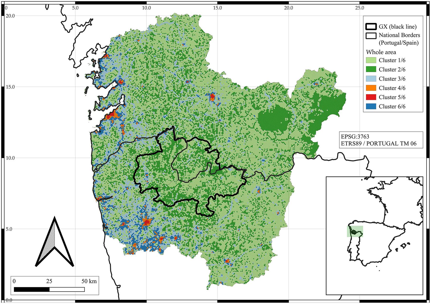
Six clusters of capital footprints in the whole area of interest (Pontevedra, Ourense, Vila Real, Braga, and Viana do Castelo). GX, Gerês-Xurés Transboundary Biosphere Reserve.
The predominance of high values across the analyzed variables is particularly evident along the coastal strip of northern Portugal and southwestern Galicia (Figure 1). In addition, the most illuminated, concentrated, connected, and industrialized areas are predominantly located in the western sector of the region (Figure 2; the Supplementary material provides further detail). Northern Portugal and southwestern Galicia share a coastal configuration, relegating the areas of nature conservation and lesser development toward the eastern side of their limits. In contrast, the + connected and industrialized areas (Clusters 3 and 6) surround the city centers and are characterized by high levels of road lengths, CO emissions, and light radiance. However, these areas also link to each other across the islands of more + illuminated and concentrated areas (Clusters 4 and 5), functioning, in many cases, as gateways for industrial activity (Figure 1).
Figure 2
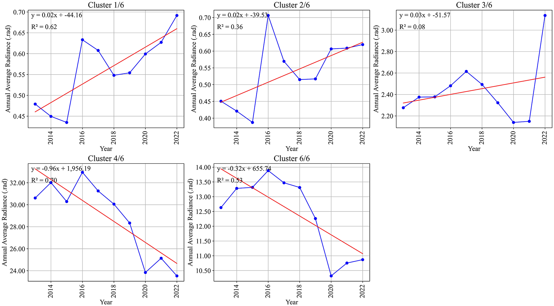
Annual average nightlight radiance per cluster within the Gerês-Xurés Transboundary Biosphere Reserve (GX; there is no Cluster 5/6 within the GX).
3.2. Classes of objectified capital footprints in the GX
The GX is currently located outside the high-density areas of capital footprints (Figure 1). A weak presence of CO emissions, total building area, nightlight radiance, and the shortest road length is observed in its cluster volume composition. Nevertheless, the average nightlight radiance in the GX has continuously increased, gaining more strength in 2022 (see Supplementary Figure S7; Gomez and Miño, 2024c,d). That is, different classes of areas in the GX have fragmented foci of electrical nightlights. The ethnographic exploration of these foci indicates that these fragmented peaks align with tourism points and concentrations of bars, restaurants, and hotels, mainly in the more illuminated and concentrated grids of Arcos de Valdevez, Ponte da Barca, and Melgaço.
In the GX, as well as in the surrounding area, nightlight radiance volumes decrease in one of the more illuminated and concentrated areas (Cluster 4). However, between 2020 and 2022, a clear upward trend of annual average nightlight radiance was very noticeable in the GX, especially in Clusters 1 and 2. Similarly, there was a slight uptick in the same period in the more connected and industrialized classes (Clusters 3 and 6; Figure 2).
4 Discussion
The analysis conducted identified three primary classes of objectified capital footprints in the region: (1) unlit and unconnected areas, (2) connected and industrialized areas, and (3) highly illuminated and concentrated urban areas. These classifications provide a nuanced characterization of the spatial differentiation in northern Portugal and southern Galicia, highlighting varying levels of infrastructural and industrial development with their spatial interrelationships. Building on Bourdieu (1979) notion of “objectified” as one of the states of any capital, this study conceptualizes roads, buildings, night-time luminosity, and CO emissions as tangible, spatially registered manifestations of capital competencies in the region. Indeed, the objectification state implies a physical realization of any capital—whether cultural, economic, political, or otherwise—by production and accumulation efforts. The general hypothesis of the broader research points out that the physical space is strongly hierarchical because the social space is too. Therefore, the possible homologies (and heterologies) between both spaces can be explored spatially by analyzing specific footprints directly or indirectly related to the active main capitals in contemporary societies. Subsequent phases of this research endeavor to integrate the socio-economic composition of each microzone, the spatial distribution of a broader list of recognized air pollutants, and the prevailing social processes in different areas. Finally, the nature protection policies in the GX region have effectively preserved the area with minimal traces of industrial activity. Therefore, continuing these measures would be advisable, particularly in the GX's transition zones, where nocturnal tourist enterprises predominate and the resident population is higher—specifically in the more illuminated and densely populated areas.
Statements
Data availability statement
The datasets presented in this study can be found in online repositories. The names of the repository/repositories and accession number(s) can be found in the article/Supplementary material.
Author contributions
RG: Conceptualization, Data curation, Investigation, Methodology, Software, Validation, Visualization, Writing – original draft, Writing – review & editing. MM: Conceptualization, Data curation, Investigation, Methodology, Software, Visualization, Writing – review & editing. VP: Methodology, Supervision, Validation, Writing – review & editing, Conceptualization. CJ: Methodology, Supervision, Validation, Writing – review & editing, Formal analysis, Investigation, Visualization.
Funding
The author(s) declare that financial support was received for the research and/or publication of this article. This project has received funding from the European Union's Horizon Europe research and innovation program under the Marie Skłodowska-Curie grant agreement no. 101108936 -SSpaceGX: “Social Space and Nature Conservation in the Gerês-Xurés Transboundary Biosphere Reserve (Portugal/Spain)”.
Conflict of interest
The authors declare that the research was conducted in the absence of any commercial or financial relationships that could be construed as a potential conflict of interest.
Generative AI statement
The author(s) declare that no Gen AI was used in the creation of this manuscript.
Publisher’s note
All claims expressed in this article are solely those of the authors and do not necessarily represent those of their affiliated organizations, or those of the publisher, the editors and the reviewers. Any product that may be evaluated in this article, or claim that may be made by its manufacturer, is not guaranteed or endorsed by the publisher.
Supplementary material
The Supplementary Material for this article can be found online at: https://www.frontiersin.org/articles/10.3389/frevc.2025.1463694/full#supplementary-material
Footnotes
1.^ For some comprehensive research on broader social space dynamics and socioecological transformations of rural regions, see Reboul (1977), Laferté (2014, 2021), Poupeau (2021), Lacuisse and Poupeau (2023), and O'Neill et al. (2024).
2.^ Detailed procedures for replication and revision are posted online (Gomez and Miño, 2024a,b,c,d).
References
1
Bing Maps (2024). GMLBF. Global Machine Learning Building Footprints. Available online at: https://github.com/microsoft/GlobalMLBuildingFootprints (accessed July 3, 2024).
2
Bourdieu P. (1979). Les trois états du capital culturel. Actes Rech. Sci. Soc.30, 3–6. 10.3406/arss.1979.2654
3
Bourdieu P. (1988). La distinción. Criterios y bases sociales del gusto. Madrid: Taurus.
4
Bourdieu P. (2018). Social space and the genesis of appropriated physical space: FORUM. Int. J. Urban Reg. Res.42, 106–114. 10.1111/1468-2427.12534
5
Calvin K. Dasgupta D. Krinner G. Mukherji A. Thorne P. W. Trisos C. et al . (2023). “IPCC, 2023: Climate Change 2023: Synthesis Report, summary for Policymakers, ” in Contribution of working groups I, II and III to the Sixth Assessment Report of the Intergovernmental Panel on Climate Change, eds. core writing team, H. lee, and J. romero (Geneva, Switzerland: IPCC), 1–34.
6
Elvidge C. D. Baugh K. Zhizhin M. Hsu F. C. Ghosh T. (2017). VIIRS night-time lights. Int. J. Remote Sens.38, 5860–5879. 10.1080/01431161.2017.1342050
7
EU/ESA/Copernicus (2024). S5P Applications. Precursor: Sentinel-5P NRTI CO: Near Real-Time Carbon Monoxide. Available online at: https://sentiwiki.copernicus.eu/web/s5p-applications (accesed July 1, 2024).
8
Gomez R. E. Miño M. G. (2024a). CoRadiance_Explorer_v1. Interactive geospatial application based on Google Earth Engine (in development).Geneva: Zenodo.
9
Gomez R. E. Miño M. G. (2024b). Workflow 1: Location of the GXTBR, Other Related Protected Natural Areas, Roads, and Traffic Data. Geneva.
10
Gomez R. E. Miño M. G. (2024c). Workflow 2: Temporal Series of Nightlight Radiance and CO Emissions. Geneva.
11
Gomez R. E. Miño M. G. (2024d). Workflow 3: Correlation Graphs and Clusters, Nightlight Radiance, and CO Emissions Maps. Geneva.
12
Iddawela Y. Lee N. Rodríguez-Pose A. (2021). Quality of sub-national government and regional development in Africa. J. Dev. Stud.57, 1282–1302. 10.1080/00220388.2021.1873286
13
Kouyate M. Arola A. Benedictow A. Bennouna Y. Blake L. Bouarar I. et al . (2024). Validation Report of the CAMS Near-Real-Time Global Atmospheric Composition Service Period June–August 2023. Reading.
14
Lacuisse M-. E. Poupeau F. (2023). La ≪ cowboy ecology ≫ revisitée. L'évolution des pratiques de pâturage et de conservation de la nature dans le sud de l'Arizona. Nat. Sci. Soc. 32, 147–16110.1051/nss/2023034
15
Laferté G. (2014). Des études rurales à l'analyse des espaces sociaux localisés. Sociologie5:423. 10.3917/socio.054.0423
16
Laferté G. (2021). Des revenus à la position sociale: reclasser les agriculteurs. Écon. Rurale 159–174. 10.4000/economierurale.9560
17
Le Roux B. Lebaron F. (2015). “La méthodologie de Pierre Bourdieu en action,” in La méthodologie de Pierre Bourdieu en action (Malakoff: Dunod), 1–20.
18
Le Roux B. Rouanet H. (2010). Multiple Correspondence Analysis. Thousand Oaks, Calif: Sage Publications.
19
Lebaron F. (2015). Pierre Bourdieu, geometric data analysis and the analysis of economic spaces and fields. For. Soc. Econ. 47, 288–304. 10.1080/07360932.2015.1043928
20
NOAA GML (2024). National Oceanic and Atmospheric Administration: Global Monitoring Laboratory. Available online at: https://gml.noaa.gov/ (accessed July 3, 2024).
21
OMF (2024). Overture Maps Foundation – Linux foundation project. Available online at: https://overturemaps.org/ (accessed July 3, 2024).
22
O'Neill B. F. Cortinas Muñoz J. Poupeau F. (2024). “Colorado River Basin water policy: using Bourdieu's field theory in the environmental policy arena,” in Bringing Bourdieu's Theory of Fields to Critical Policy Analysis, (Cheltenham: Edward Elgar Publishing), 56–73.
23
OSM (2024). Open Street Map. Available online at: https://www.openstreetmap.org/#map=7/39.602/-7.839 (accessed July 1, 2024).
24
Pereira V. B. (2024). “Renewing sociological research on the urban with Bourdieu,” in Research Handbook on Urban Sociology (Cheltenham: Edward Elgar Publishing), 120–134.
25
Poupeau F. (2021). De la critique écologique à la critique sociale. Auto-organisation communautaire et autonomie des dominés. Espaces Soc. 180-181, 137–154. 10.3917/esp.180.0137
26
Reboul C. (1977). Déterminants sociaux de la fertilité des sols//Post-scriptum: fertilité agronomique et fertilité économique. Actes Rech. Sci. Soc.17, 85–112. 10.3406/arss.1977.2578
27
TomTom (2024). TomTom Developer. Available online at: https://developer.tomtom.com/documentation (accessed July 3, 2024).
28
Trillo-Santamaría J-. M. Pauel V. (2016). Transboundary protected areas as ideal tools? Analyzing the Gerês-Xurés transboundary biosphere reserve. Land Use Policy52, 454–463. 10.1016/j.landusepol.2015.12.019
29
Wacquant L. (2023). Bourdieu in the City: Challenging Urban Theory. Cambridge: Polity Press.
Summary
Keywords
social space, physical space, capital, biosphere, Gerês-Xurés
Citation
Gómez RE, Miño MG, Pereira VB and Jardón CM (2025) Spatial distribution and classification of objectified capital in the Gerês-Xurés Transboundary Biosphere Reserve. Front. Environ. Econ. 4:1463694. doi: 10.3389/frevc.2025.1463694
Received
31 October 2024
Accepted
07 April 2025
Published
07 May 2025
Volume
4 - 2025
Edited by
Thomas Ramsey, China Three Gorges University, China
Reviewed by
Min An, China Three Gorges University, China
Qingling Peng, Hohai University, China
Buck Ryan, University of Kentucky, United States
Yang Yang, China Three Gorges University, China
Updates
Copyright
© 2025 Gómez, Miño, Pereira and Jardón.
This is an open-access article distributed under the terms of the Creative Commons Attribution License (CC BY). The use, distribution or reproduction in other forums is permitted, provided the original author(s) and the copyright owner(s) are credited and that the original publication in this journal is cited, in accordance with accepted academic practice. No use, distribution or reproduction is permitted which does not comply with these terms.
*Correspondence: Raimundo Elías Gómez lsgomez001@gmail.com
Disclaimer
All claims expressed in this article are solely those of the authors and do not necessarily represent those of their affiliated organizations, or those of the publisher, the editors and the reviewers. Any product that may be evaluated in this article or claim that may be made by its manufacturer is not guaranteed or endorsed by the publisher.