 Jinzhu Gao
 Jian Ding1
- 1Marine Spatial Planning Division, National Marine Data and Information Service, Tianjin, China
- 2Key Laboratory of Ocean Space Resource Management Technology, Ministry of Natural Resources of the People's Republic of China (MNR), Hangzhou, China
Introduction: In the future, China's mariculture must maintain its scale and improve quality. Crucial measures for achieving this goal are to optimize the layout of sea areas for aquaculture, strengthen the suitability assessment of marine aquaculture, and delineate suitable areas.
Methods: This study aims to scientifically identify marine aquaculture zones suitable for marine spatial planning by constructing a comprehensive suitability assessment system, incorporating both natural and social factors. The weights of the evaluation indicators were determined using the Analytic Hierarchy Process (AHP). Taking the Lianyungang sea area as a case study, GIS technology was employed to analyze marine aquaculture suitability based on the proposed index system.
Results: The results categorized the Lianyungang sea area into aquaculture zones with varying suitability levels: excellent, good, average, poor, and very poor. Based on these findings, the study further classified the area into three types of management zones: key, moderate, and limited mariculture zones.
Discussion: In order to provide better decision support services and take into account the matching with Marine spatial planning and double evaluation, it is necessary to classify the evaluation results to facilitate users to propose scientific and practical management measures in this paper. Based on the evaluation results of mariculture suitability in the research area, it is necessary to strengthen the protection and development of mariculture suitable areas by providing sufficient resources and maximizing development potential.
1 Introduction
Marine aquaculture is a traditional maritime development and utilization activity with a significant role in ensuring the production and livelihood of fishermen and promoting the economic and social development of coastal areas. The Food and Agriculture Organization of the United Nations has released the 2024 edition of the “State of World Fisheries and Aquaculture” report, proposing that global fisheries and aquaculture production reached a new high, with the total global fisheries and aquaculture production has soared to 223.2 million tons in 2022. As the world’s largest marine aquaculture country, China plays a significant role in global seafood production, according to the statistics, the total amount of seawater aquaculture in China will exceed 36.6 million tons in 2024, with marine aquaculture as its main form of marine area utilization, accounting for 84% of all marine-use areas in China. While guaranteeing the supply of high-quality protein and reducing the intensity of fishing operations, it also involves spatial conflicts, environmental pollution, and ecological disturbances. In the future, China’s marine aquaculture must maintain its scale and improve quality (Zheng et al., 2023; Yu and Jiang, 2024). Crucial measures for achieving this goal are to optimize the layout of sea areas for aquaculture, strengthen the suitability assessment of marine aquaculture, and delineate suitable areas. These actions are important when guiding marine aquaculture activities, maximizing marine spatial patterns, protecting the marine environment, and ensuring sustainable use of marine resources.
Suitability assessment is a process that analyzes the appropriateness of a development or utilization method, and implements a grade evaluation (Jing et al., 2024). It has extensive applications, with the main fields including urban construction, agriculture, disaster prevention, nature reserves, and tourist area land use (Sathiyamurthi et al., 2024; Gao et al., 2024b; Ma et al., 2024; Sun and Shi, 2024; Yi et al., 2024), and has become an essential method in spatial planning research. The spatial suitability assessment proposed in this paper refers to the analysis of the degree of suitability of a certain type of development and utilization for a given space, based on spatial resource conditions and specific types of development and utilization. This involves defining clear levels and regional scopes (Qin et al., 2018). This method has been widely applied in areas such as land use (Yin et al., 2013; Xu et al., 2024; Fu et al., 2022; Li et al., 2023; Feng et al., 2022), agriculture (Luo, 2023; Rong and Li, 2023), and ecological protection (Han et al., 2023; Qu et al., 2023). However, its application in marine spaces, especially in mariculture spaces, is uncommon. Some scholars have applied spatial suitability assessment to divide different functional areas in marine space (Gao et al., 2023b; Li et al., 2022; Liu et al., 2022; Fei et al., 2023; Drackett et al., 2023) and island development (Gu et al., 2022). There are also scholars who conduct suitability evaluations on coastlines, clarifying the development and protection orientation and requirements for different types of coastlines (Yuan et al., 2021; Chen et al., 2023; Yuan et al., 2021). And other scholars have evaluated the suitability of marine spatial development from the perspective of ecosystem services (Ma et al., 2022; Xiang et al., 2018). Only a few scholars have researched the suitability evaluation of marine space for certain types of development and utilization activities, such as offshore wind power (Latinopoulos and Kechagia, 2015; Huang et al., 2022a; Vasileiou et al., 2017), sea sand mining (Cheng et al., 2024; Qin et al., 2022), water intake points (Zhang et al., 2023; Huang et al., 2022b), coastal bathing areas (Wu, 2023), and marine aquaculture (Beard et al., 2020; Suo et al., 2023; Li et al., 2024). Some scholars use bivariate copulas to evaluate the suitability of seawater aquaculture (Santjer et al., 2024), others assess site suitability and develop a spatial bioeconomic model (Thomas et al., 2019), they explored the method model for evaluating the suitability of mariculture. And these existing suitability evaluation mainly focused on the specific space such as coastal mudflats (Drackett et al., 2023), islands (Li et al., 2017; Gao et al., 2023a) and nearshore sea (Xu et al., 2016). Therefore, starting with the practical needs of optimizing and managing aquaculture sea areas in China, this paper uses GIS tools to establish a set of universally applicable evaluation indicators of mariculture suitability for studying the spatial distribution characteristics of mariculture suitability in this area, choosing the Lianyungang sea area as the research region. The important innovation points of the paper are to try to innovate the construction of index system of mariculture suitability assessment, taking into account both natural and social factors comprehensively. In this way, the appropriate area for mariculture can be selected to further assist the zoning and adjustment of marine spatial planning. And it supports the formulation of suitable mariculture area delineation schemes and provides technical support for spatial management policies in marine and fishery management. In addition, the amount of data involved in this paper is small and not suitable for objective weighting method, which is easy to cause weight instability. The influencing factors of mariculture involve the professional subject knowledge, and the influence degree of each factor is also professional. By using AHP to determine the weights of indicators, the experience knowledge of experts in the field of mariculture can be combined with their rational analysis, so as to minimize the uncertain factors in the analysis process and simplify the complex problems.
2 Materials and methods
2.1 Study area and data sources
Lianyungang (33°58′55″N - 35°08′30″N, 118°24′03″E - 119°54′51″E) lies on the west of the Yellow Sea and is located on the northeastern tip of Jiangsu Province, as shown in Figure 1. Lianyungang is known for its diversity of coastal zones, which extends over a total length of 195.93 km. Unique rocky and sandy shorelines are spread along its coastal region. It has 20 islands, among which the Lian Island is the largest island in the Jiangsu Province, covering an area of 6.07 km2. Lianyungang has a flat terrain and 17 seagoing rivers, including Guan River and Linhong River. It also has a great variety of ecosystems, such as estuary, nearshore, shallow sea, and intertidal ecosystems. Lianyungang has developed marine fisheries and is a typical bay-type area in the north of China. The coastal mudflat covers an area of nearly 20,000 km2. The offshore area of Lianyungang is the Haizhou Bay fishing grounds. Choosing the Lianyungang sea area as the research region can better represent the situation of mariculture in the north of China, which can provide better verification for the research results. At the same time, the data in the Lianyungang sea area is relatively detailed, which facilitates the selection of indicators for fishery suitability evaluation methods and minimizes the selection bias caused by data collection.
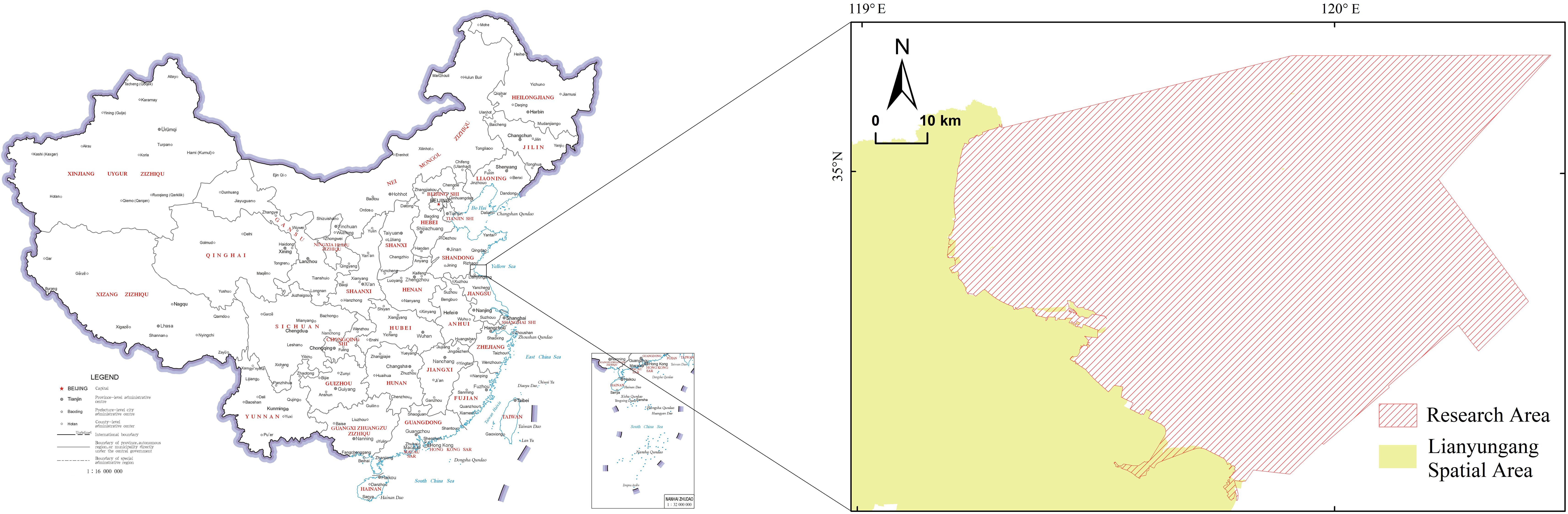
Figure 1. Map of the study area.
(Censor Code: GS (2019) NO.1686 Produced from the Ministry of Natural Resources of the People’s Republic of China.)
Satellite remote sensing images, environmental monitoring data, and MODIS data with a spatial resolution of 250m were selected for the years 2023 from the study area. These dates were procured from NASA, the official website of the Ministry of Ecology and Environment, and the National Marine Data and Information Center. The study area evaluation unit was 250m×250m.
2.2 Research methods
The research steps in this paper were as follows: firstly, the index system of mariculture suitability assessment was constructed from two dimensions of nature and society, and the weight of each index was determined by AHP method. Secondly, the research area was divided into 250m×250m units, the index values of each unit were calculated and their standard scores were determined according the suitability assessment criteria of indicators. Thirdly, the mariculture suitability calculation results of each unit were obtained by weighting and summing the standard scores of each unit. Fourthly, the suitability calculation results are divided into five levels based on the natural breakpoint method. Finally, based on five levels results of suitability calculation, the research area were categorized as key, moderate, and limit mariculture zones.
2.2.1 Index system of mariculture suitability assessment
Lianyungang is rich in tidal flat resources and has good natural conditions for developing mariculture. Mariculture species include portunid, Chinese prawn, nori, oysters, mussels, scallops, perch and so on. The culture environment of these mariculture species mainly has higher requirements for seawater quality, water temperature, salinity, leaf green a and so on. Considering the key factors influencing mariculture suitability and mariculture species, the index system of mariculture suitability assessment (Table 1) was determined by considering two domains: natural aspects and social aspects. Specifically, three layers (target, control, variable) were included in the index system. The target layer was the mariculture suitability assessment index which was calculated by using Equation 9, and it evaluated the distribution of different levels of mariculture suitability in the study area. Hydrological and ecological factors were selected in the natural aspect, which included marine primary productivity index, seawater quality index, seawater eutrophication index, Chlorophyll a concentration, water depth, salinity, and temperature (Qiu et al., 2018; Zhang et al., 2024; Lin et al., 2014)). Among them, marine primary productivity index, seawater quality index, and seawater eutrophication index were composite indicators. The distance from coastline, distance from fishing port, and distance from town (Liu et al., 2021)were mainly selected for the social aspect from the economic cost point. In addition, considering the representativeness of indicators and data availability, this paper focused on the selection of indicators that reflected the natural state of marine space and the fishery activities. These indicators were obtained by combining previous research, consulting expert opinions and inquiring existing literature. These indicators can reflect independently or influence each other to determine their impact on mariculture activities, and constitute the attribute parameters that must be considered in the mariculture industry activities, such as water quality, chlorophyll concentration, water temperature, salinity, water depth, etc. There were other factors that can affect mariculture areas, such as the location of ecological protection areas, shipping channels, ship anchorage, special purpose areas, etc. However, these indicators mainly reflected the exclusivity of mariculture areas, and were not research priorities in this paper.
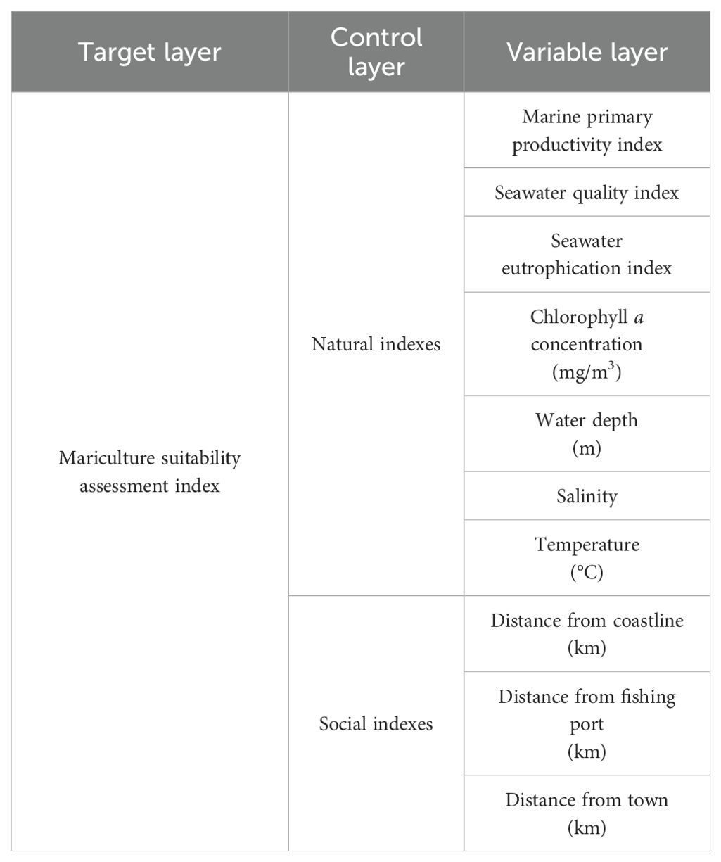
Table 1. Index system of mariculture suitability assessment.
2.2.2 Calculation methods for comprehensive indexes
2.2.2.1 Marine primary productivity index
In this study, the chlorophyll assimilation index method was used to calculate the marine primary productivity (PP) (Cadee, 1975; Gao et al., 2024a). PP can be deduced as with Equations 1–3:
where is the marine primary productivity of the study area (measured by CO2) (mg/(m2·d)); is the concentration of Chlorophyll a in seawater (mg/m3); Q is the assimilation coefficient (mgC·mg/(Chla·h)) and the empirical value is 3.7; D is the annual average light duration (h/d) and is calculated according to Table 2 (Liu et al., 2019).
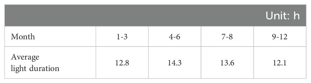
Table 2. Average light duration of per month.
(*By averaging the average light time data of each month, the average light time data of each quarter is obtained.)
The euphotic layer depth of the sea can be deduced with Equation 4:
2.2.2.2 Seawater eutrophication index
To a certain extent, the seawater eutrophication index reflects information about marine environmental quality, and is widely used to evaluate seawater eutrophication status. It has been constantly redefined and developed in application. The eutrophication index (E) from the Bulletin of Marine Ecology and Environment Status of China released by the Ministry of Ecology and Environment was adopted in this paper. E can be deduced with Equation 5:
where, , and are respectively the concentrations of inorganic nitrogen, inorganic phosphorus, and chemical oxygen demand. Their unit are .
2.2.2.3 Seawater quality index
The Nemerow comprehensive index method was used to measure regional seawater quality in this paper. This is the most common method for evaluating the comprehensive seawater pollution index. It is a weighted multi-factor environmental quality index that considers both the extreme value or the prominent maximum value. P can be deduced with Equation 6:
where, is the seawater monitoring concentration of the ith item, is the standard concentration of lever 2 seawater environmental quality of ith item. P ≤ 1 indicates that the comprehensive quality of seawater is up to standard. P>1 indicates that the comprehensive water quality of seawater exceeds the standard.
2.2.3 Index weight determination method: analytic hierarchy process
Analytic Hierarchy Process (AHP) analyzes the relationship between the basic elements in the evaluation system and establishes a systematic hierarchical recursive structure. When applying AHP to analyze a decision problem, the problem is first organized and hierarchized, and the decision problem is to build a recursive hierarchy model (Gao et al., 2022). Then all judgment matrices in each layer are constructed and the importance scale (e0/5- e8/5 exponential scale method) is used to define the judgment matrix A=(aij)n×n (Huang et al., 2022c), and judgment matrix A conducts the hierarchical single arrangement and consistency test:
Consistency testing is intended to determine the allowable range of inconsistencies for the judgement matrix. According to the maximum eigenvalue of judgement matrix A, the consistency index CI is obtained in Equation 7. RI is the average random consistency index (Table 3), a fixed order ‘n’ has a fixed RI value, and CR corresponds to the consistency ratio. Equation 8 is used to calculate CR. When CR<0.10, the consistency of judgment matrix A is accepted. Otherwise, the judgment matrix should be modified. Order represents the order of the matrix A.
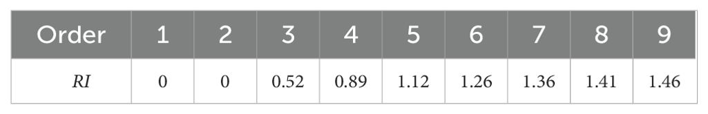
Table 3. Average random consistency index (Gao et al., 2022).
Finally, the overall hierarchical arrangement was obtained. The composite weight of each element in the last three levels of indicators to the target layer is is obtained in Equation 9.
2.2.4 Suitability assessment criteria of indexes
In this paper, the measurement units and properties of each index were different in the assessment index system, so they cannot be directly compared and calculated. Therefore, the method of assigning points was used to reclassify the raster data of each index to obtain the standardized score value and its spatial distribution, in which 5 points was the most suitable and 1 point was the least suitable. Reference to the evaluation criteria proposed by relevant experts in the study of suitability evaluation of mariculture, the standard scores and thresholds of suitability assessment for indicators in this paper were established, as shown in Table 4. Marine primary productivity index was classified by the natural breakpoint method. Seawater eutrophication index referred to the eutrophication status rating in the Bulletin of Marine Ecology and Environment Status of China. Seawater quality index was intended to classify the pollution degree of sea area according to the corresponding relationship between the Nemerow comprehensive index and the standard grade of sea water quality (Shao et al., 2020; Zhang et al., 2019; Lei et al., 2014; Standardization Administration of the People’s Republic of China, 1997). Water depth, temperature, salinity, and chlorophyll a concentration referred to the preliminary research conclusions on the suitability conditions for mariculture proposed by several scholars (Shi et al, 2008; Fast and Pagen, 1974; Silva et al., 2011). The distances from coastline, fishing port, and from town referred to several scholars’ research (Zhang et al., 2024; Lin et al., 2014) on the comprehensive assessment of mariculture suitability.
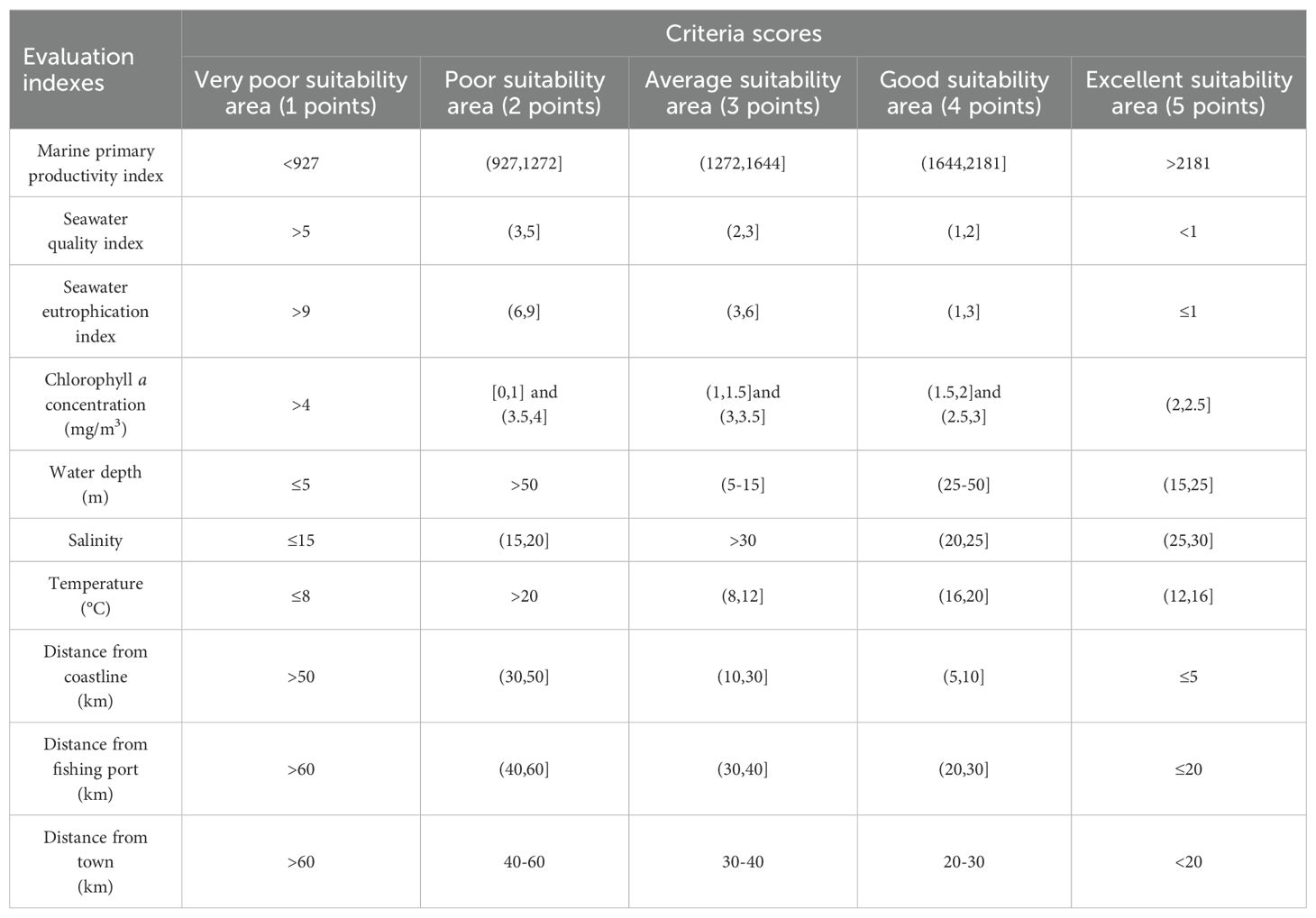
Table 4. Suitability assessment criteria of indexes.
2.2.5 Method of mariculture suitability assessment index
After determining the score value and weight of each index, the standard score values of each unit were weighted and summed by using Equation 10 to obtain the mariculture suitability assessment index (MSAI). This paper adopted the weighted summation model, and can be deduced as:
where is the weight of the ith indicator, is the value of the ith indicator, and n is the number of evaluation indicators.
3 Results
3.1 Index weights
We invited 10 experts to score the index system, which included marine economy, marine spatial planning, and integrated marine management. According to the basic data and experts’ marking, the weights of indicators were determined based on the AHP. The calculation results are detailed in Tables 5, 6. After consistency test for the scores obtained by each expert, CI was all less than 0.1, indicating a good consistency.
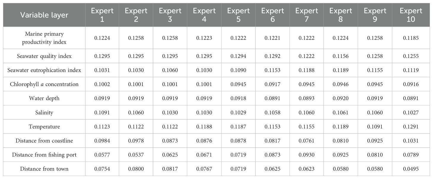
Table 5. The comprehensive weights obtained by 10 experts.
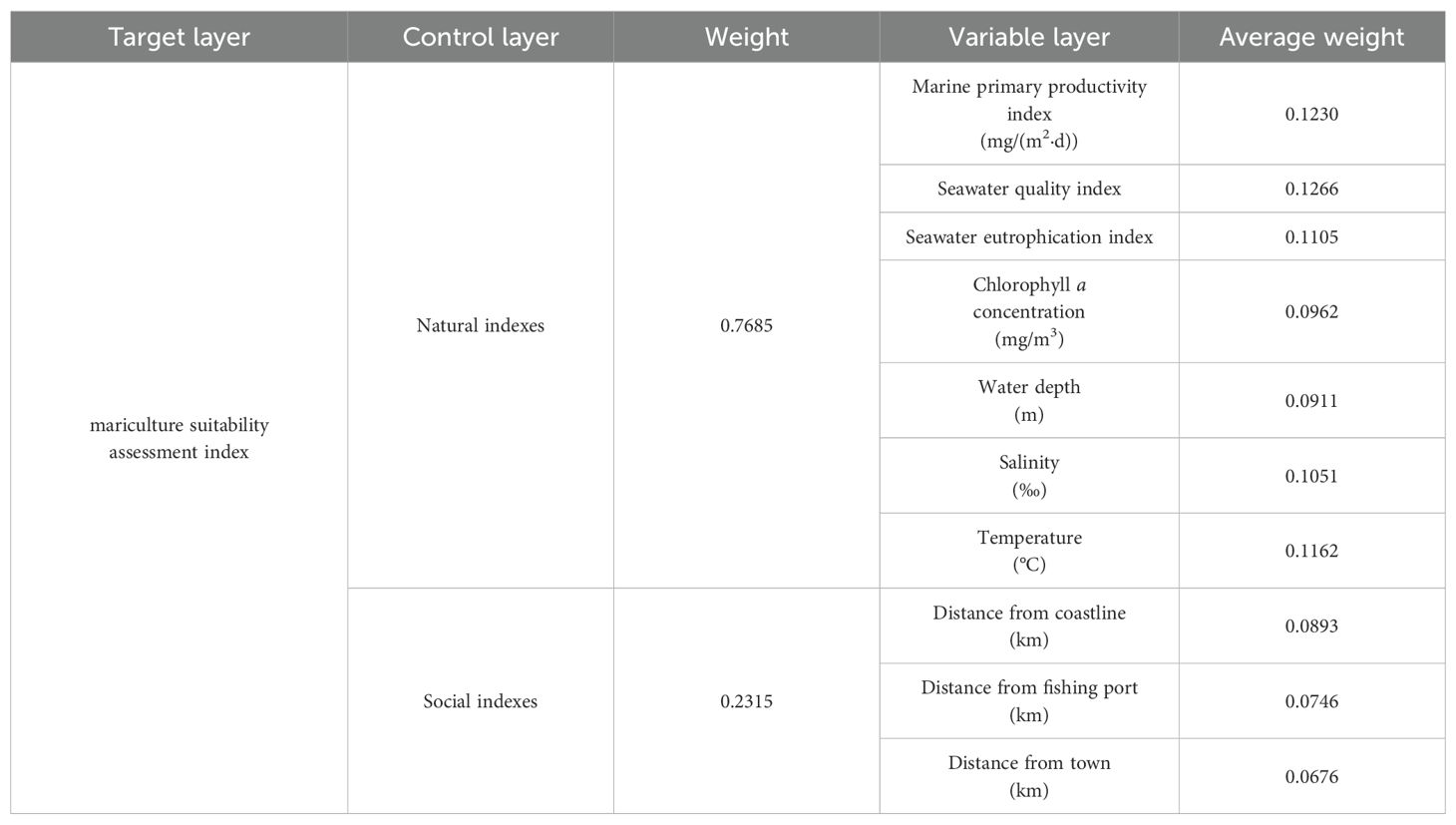
Table 6. The weights of indexes.
3.2 Calculation result of natural indexes
The GIS tool was applied to perform a raster interpolation on data such as depth, temperature, salinity, and Chlorophyll a concentration to obtain the planar distribution results of various indicators, as shown in Figures 2A-D. These pictures showed the distribution of water depth, water temperature, salinity and Chlorophyll a concentration in the study area, and the data were all annual average data.
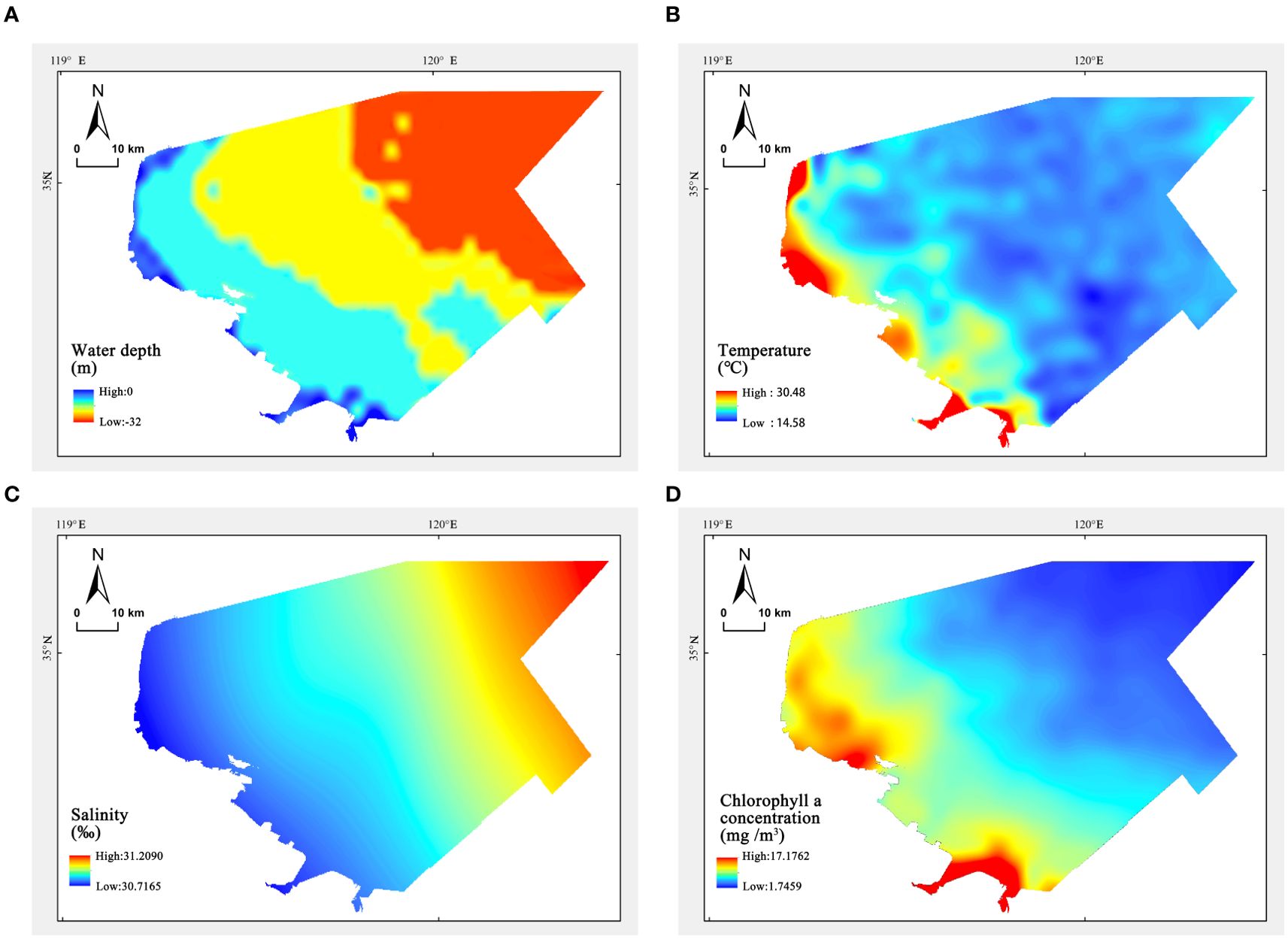
Figure 2. (A) Water depth distribution profile (B) Temperature distribution profile (C) Salinity distribution profile (D) Chlorophyll a concentration distribution profile.
The water depth in the study area gradually deepens from the land to the open sea. Influenced by the land, the temperature and salinity of the water are inversely proportional to the depth, with higher temperatures and lower salinities near the land. The planar spatial distribution of depth, temperature, and salinity is detailed in Figures 2A–C. The Chlorophyll a concentration in the study area ranges between 1.75-17.28 μg/L. Overall, the Chlorophyll a concentration is higher near the coast, especially near the mouths of the Linhong and Guan Rivers, compared to the open sea. Other areas show limited spatial variation in Chlorophyll a concentration. The planar distribution of Chlorophyll a concentration is detailed in Figure 2D.
Using formulas (3), (5), and (6), the grid data for indices such as the marine primary productivity index, seawater eutrophication index, and seawater quality index were calculated, as shown in Figures 3A-C. The results indicate that the seawater quality index ranges from 0.5466-1.2011. From a spatial distribution perspective, the overall seawater values in the study area are at a generally clean level, with low values appearing around the Guan River estuary, mainly affected by land-based pollutant discharge into the sea. The eutrophication index ranges between 0 and 0.7498. According to the eutrophication classification evaluation standards, most of the sea areas did not exhibit eutrophication; only areas near Guannan County and Haizhou Bay showed mild eutrophication, with high values appearing in the Guan River estuary area. The primary productivity index ranges from 0 to 3560.6. The overall primary productivity level in the study area is good, with dominant areas primarily located in the southern part of Haizhou Bay and Lianyun District, as well as around the ancient Po Shanhou River. The data of seawater quality and seawater eutrophication were all from marine monitoring stations, and the grid data covering the whole study area can be obtained by using the differences of the measured data of each monitoring station.
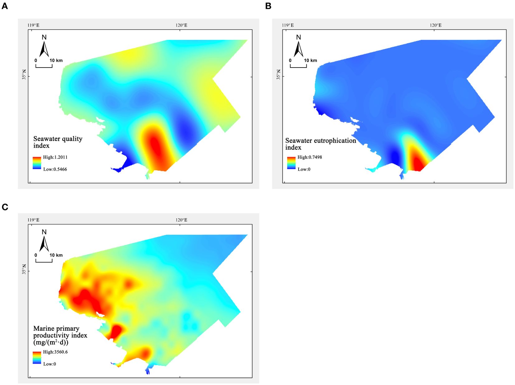
Figure 3. (A) Distribution profile of seawater quality index (B) Distribution profile of seawater eutrophication index (C) Distribution profile of marine primary productivity index.
3.3 The results of natural and social suitability assessment for mariculture
The grid data of each index is standardized according to the suitability assessment criteria of indexes. The grid calculation is performed by formula (10). The natural breakpoint method divides the suitability level into five levels. After reclassification, the results of the natural suitability assessment and social suitability assessment are obtained.
The results of the natural suitability assessment show (Figure 4) that the water temperature in the study area is very suitable for marine aquaculture. The Chlorophyll a concentration and primary productivity are higher in areas closer to the coastline, while the water quality in the sea is poorer, with these two driving factors constraining each other. Most of the study area is suitable for marine aquaculture, with highly suitable areas mainly concentrated in the central and eastern deep-sea regions. The coastal area near the Guan River estuary has become a concentrated area of low suitability due to reasons such as lower seawater quality and primary productivity. Overall, the suitability of the central and eastern sea areas in the study region is significantly higher than that of the western coastal areas.
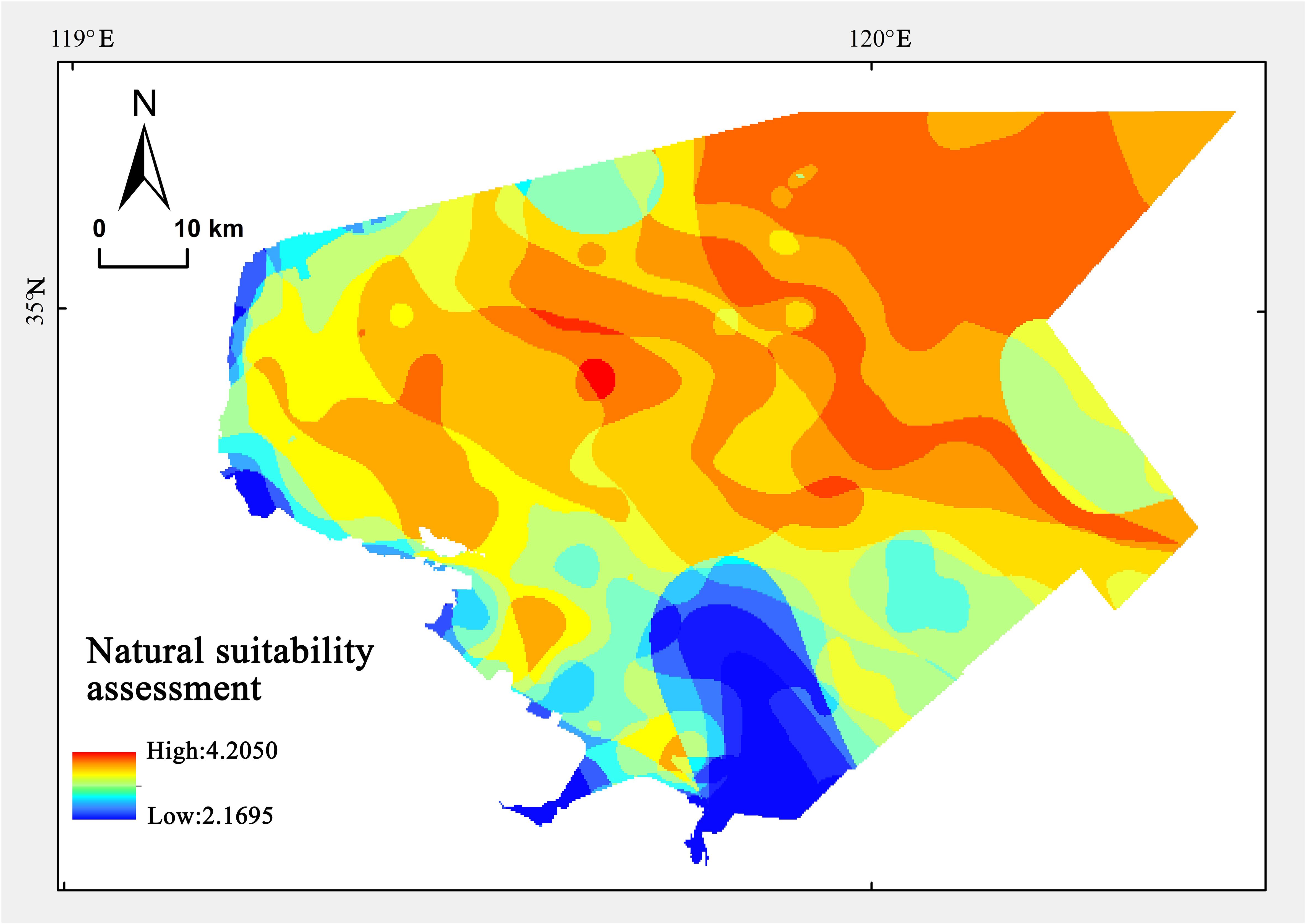
Figure 4. The results of natural suitability assessment.
Considering economic and convenience factors, the distance from offshore, port, and town directly affects the difficulty of developing marine aquaculture. Areas closer to the coastline have a higher level of infrastructure convenience, making them more suitable for mariculture. The results of the social suitability assessment show (Figure 5) that the degree of suitability is centered around ports, towns, and shorelines, distributed in concentric circles towards the eastern sea area, with highly adaptable areas mainly concentrated within a 10km range near the shore.
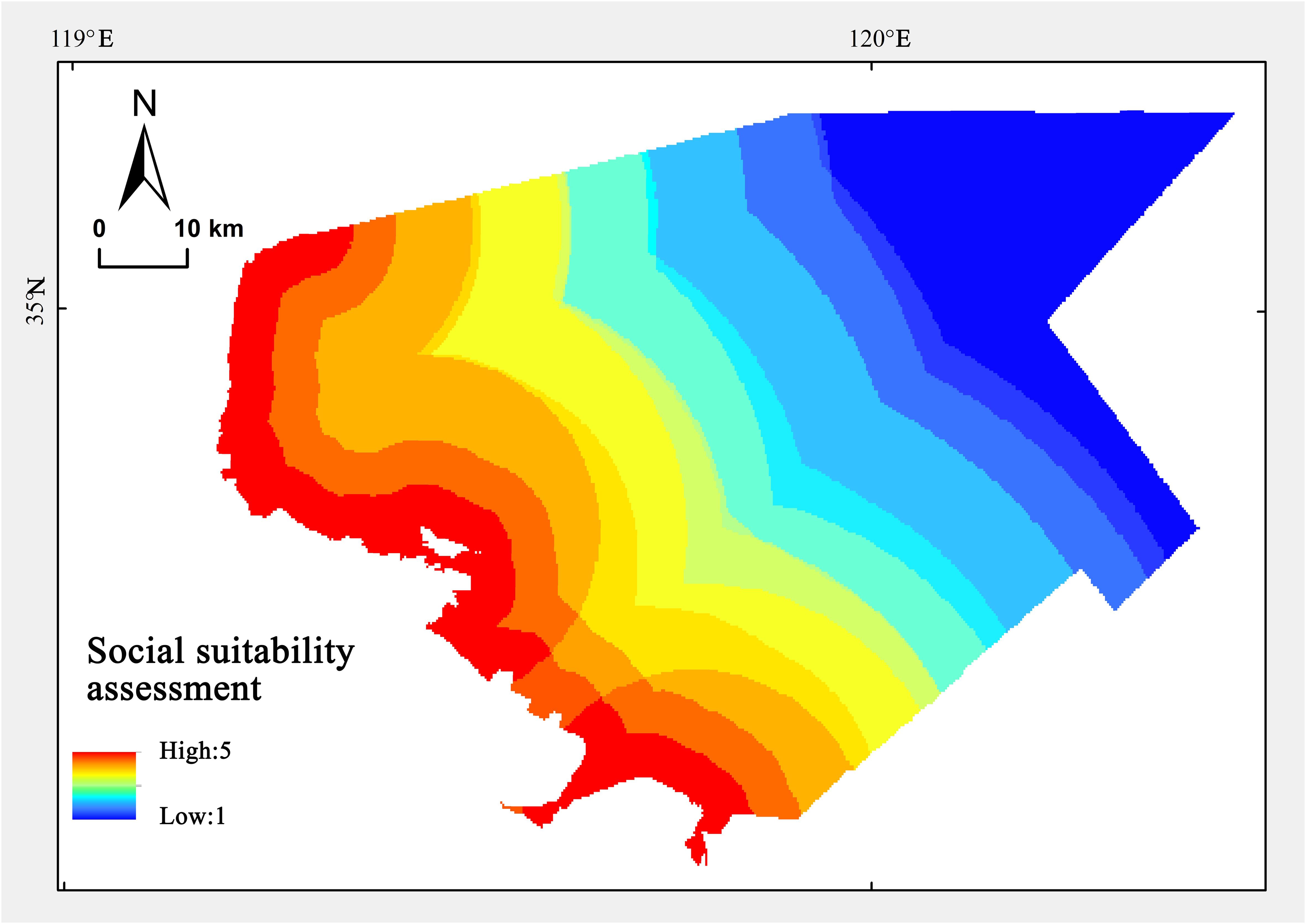
Figure 5. The results of social suitability assessment.
3.4 The results of mariculture suitability assessment index
The mariculture suitability assessment index is calculated according to formula (10), and the suitability calculation results are divided into five levels based on the natural breakpoint method, reclassifying to generate the evaluation results of mariculture suitability. The spatial distribution of different suitability marine areas is shown in Figure 6. The results of the mariculture suitability assessment index indicate that the area of seawater with moderately high suitability is 3070.25 km2, accounting for 61.79% of the total area of the study region. Among them, the area of highly suitable mariculture is 902.97 km2, accounting for 18.17% of the total study area, mainly distributed in the coastal waters near Haizhou Bay and Lianyun District in the south. The area of relatively highly suitable mariculture is 1016.32 km2, accounting for 20.45% of the total study area, mainly distributed in the central part of Haizhou Bay. This area is mainly limited by distance, resulting in a decrease in suitability. The moderately suitable sea area covers 1150.96 km2, accounting for 23.16% of the total. The chlorophyll concentration and primary productivity in this sea area are slightly lower, and it is further away from urban areas. The combined effects of multiple factors reduced the suitability of marine aquaculture in this region.
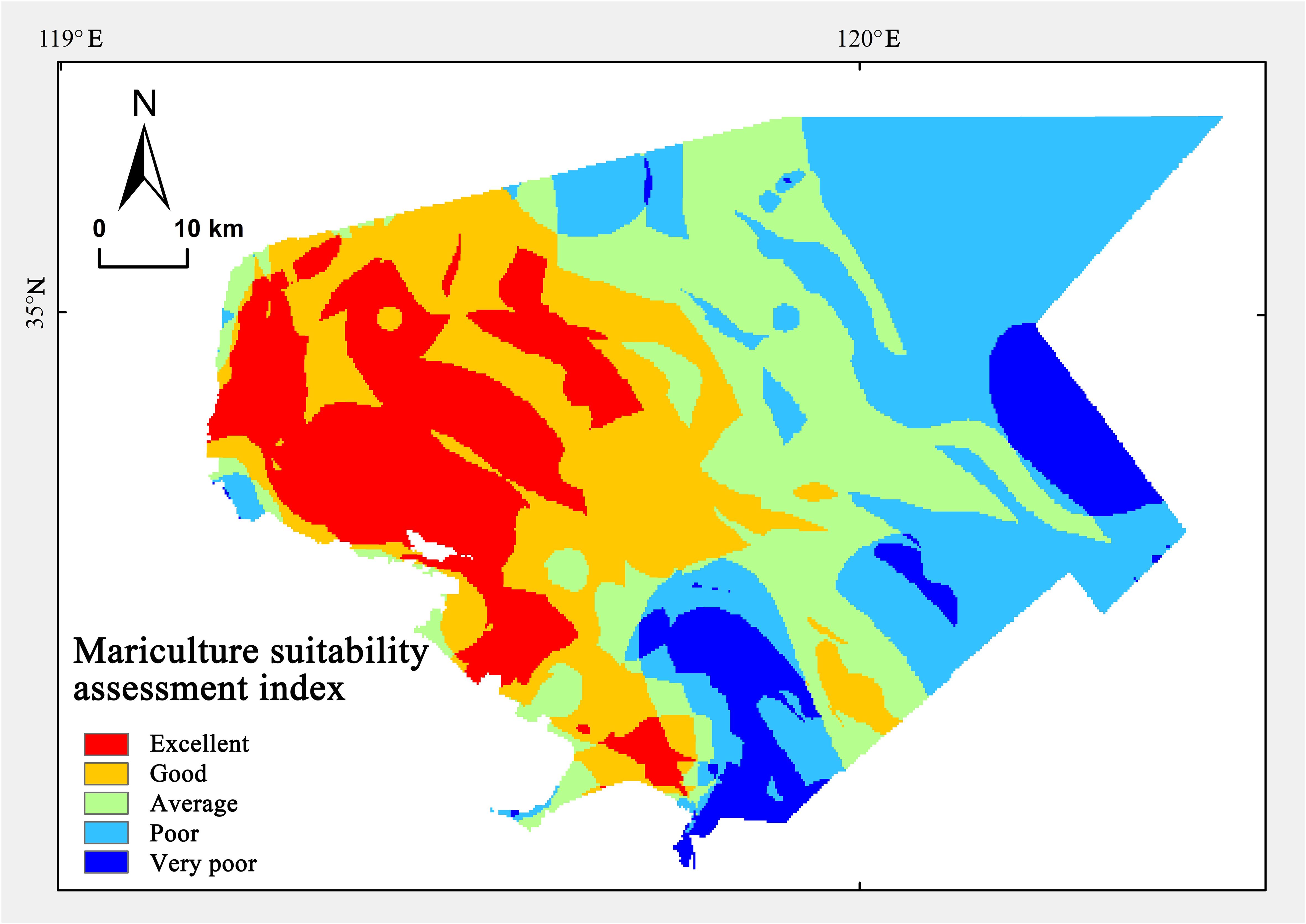
Figure 6. The results of mariculture suitability assessment index.
The areas of lower and low-suitability seas are 1501.64 km2 and 397.00 km2, accounting for 30.22% and 7.90% respectively. A portion of these is concentrated in the eastern offshore areas. The main reason for the low suitability is the distance from land, which results in lower primary productivity, affecting the efficiency of marine aquaculture. Another part is concentrated around the mouth of the Guan River, where water pollution reduced the suitability of this area.
4 Discussion
In order to provide better decision support services and take into account the matching with Marine spatial planning and double evaluation, it is necessary to classify the evaluation results to facilitate users to propose scientific and practical management measures. Based on the evaluation results of mariculture suitability in the research area, it is necessary to strengthen the protection and development of mariculture suitable areas by providing sufficient resources and maximizing development potential. Targeted ecological restoration and environmental improvement measures should be taken in areas where mariculture functions have degraded (Yang et al., 2023; Jin et al., 2023; Liu et al., 2021). This will maximize the restoration of ecological functions and resource conservation, thereby enhancing regional biodiversity and ensuring the safety baseline of resources (Wu et al., 2020). Based on varying degrees of suitability for marine aquaculture in different regions, the study area is divided into three types of mariculture management zones according to development strategies (Lv et al., 2023; An et al., 2022) (Figure 7). These are categorized as key, moderate, and limit mariculture zones.
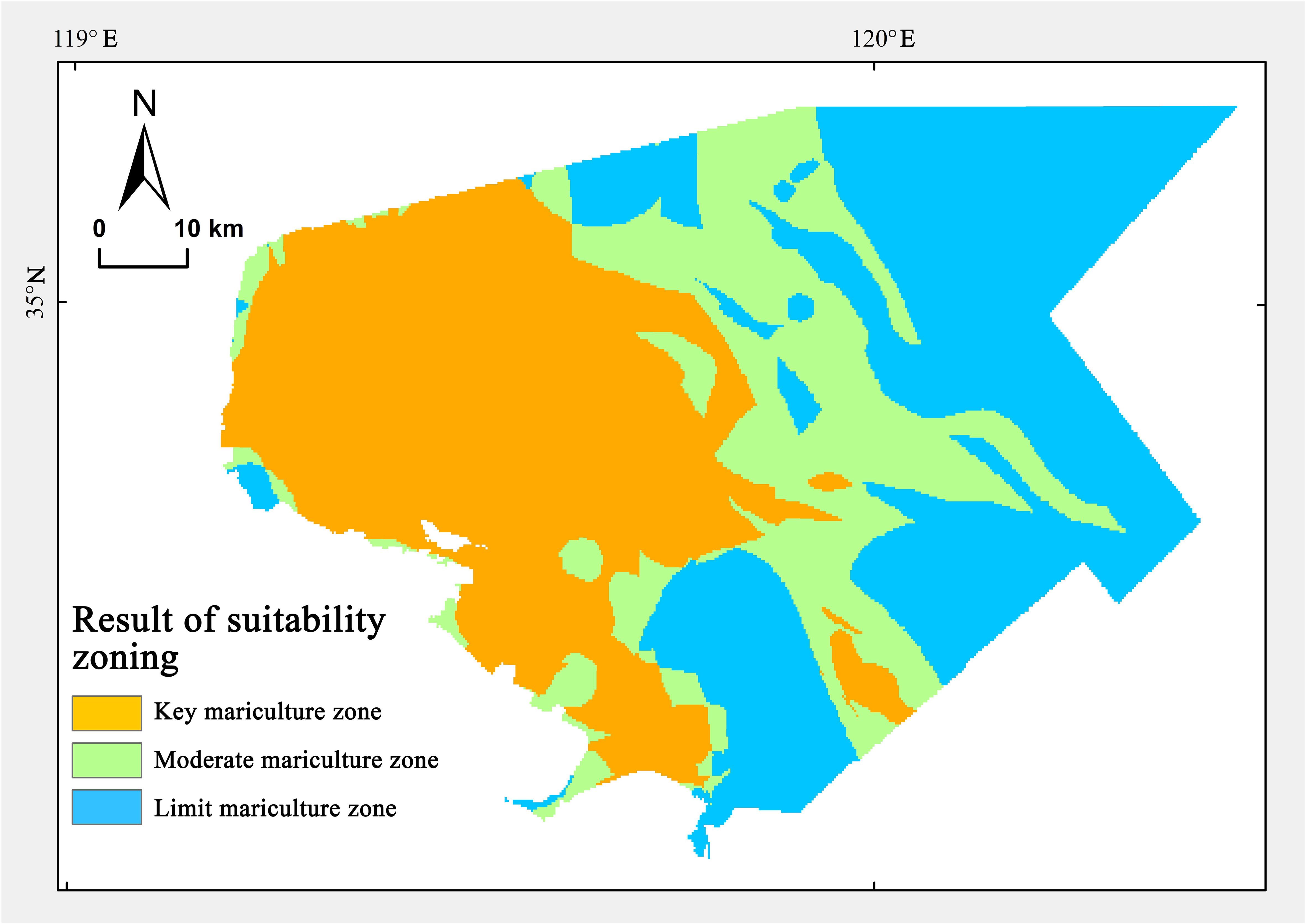
Figure 7. The results of suitability zoning for mariculture.
The key mariculture area, which refers to the space where the suitability evaluation results for marine farming are high or relatively high, is mainly distributed in the coastal waters of Haizhou Bay, covering an area of 1919.29 km2, accounting for 38.63% of the total study area. The key mariculture area is a crucial development zone for promoting marine farming and enhancing and stabilizing seafood production, having a significant supporting role in achieving food security goals. In key mariculture areas, it is necessary to optimize the layout and development of sea areas for mariculture, effectively ensuring the production and living needs of fishermen and the demand for sea areas in modern fishery development. Key mariculture areas are close to the shore and influenced by ecological protection areas, ports, and navigation channels. Some sea areas used for mariculture must be given up, and nearshore marine mariculture space has limited growth. Therefore, key mariculture areas should focus on improving marine mariculture technology and spatial utilization efficiency, properly manage mariculture wastewater, adopt overall guidance of ‘no increase or decrease, basically stable’, implement large-scale and three-dimensional mariculture, and promote the construction of a ‘blue granary’. The above management measures are conducive to improving the quality and output of mariculture products under the premise of limited space increment, which is in line with the location conditions and utilization status of key aquaculture areas.
The moderate mariculture area refers to the space where the suitability evaluation results for marine mariculture are moderately suitable, mainly distributed in the central sea area of Lianyungang, covering an area of 1150.96 km2, accounting for 23.16% of the total study area. The suitable mariculture area is the potential incremental space for seawater mariculture and is crucial for stabilizing or increasing the overall mariculture area. As offshore mariculture is far from suitable breeding areas and has fewer spatial conflicts, the primary goal should be to ensure the supply of seafood. We should extensively develop deep-sea mariculture, rely on intelligent and intensive large-scale mariculture facilities, promote factory farming, and construct marine ranches in deep waters and near distant shores. Marine ranching in the current international context is broadly divided into two categories. The first involves large-scale fishery resource enhancement through the construction of artificial reefs, represented by countries such as China, Japan, and South Korea. The second is primarily aimed at conservation of marine fishery resources and development of recreational fishing, represented by Europe and America. Considering the general conditions of water quality and primary productivity in moderate mariculture areas, it is recommended to prioritize the development of conservation-oriented marine ranches by preserving and appreciating ecological capital. Moderate development should also be considered for reproductive and recreational marine ranches. The above management measures help to increase the incremental space of mariculture and ensure the output of mariculture. At the same time, it plays a key role in the consolidation and promotion of Marine primary productivity.
The restricted mariculture area refers to the evaluation results of the suitability of sea areas for mariculture, which are low or relatively low. These areas are mainly located in the southern coastal waters of Lianyungang and eastern offshore waters, covering an area of 1898.64 km2, accounting for 38.21% of the total study area. The region is primarily constrained in terms of reducing the suitability for seawater mariculture due to factors such as port construction and terrestrial pollution entering the sea at river mouths. In restricted mariculture areas, the entry of mariculture activities should be restricted and enclosed mariculture should be reduced or withdrawn. It is also necessary to retreat from the shoreline and return to the beach and sea to strengthen restoration of coastal ecological and protection of biological resources, increase nearshore ecological space, and enhance conservation of regional fishery resources. The above management measures help coordinate the use of sea space for mariculture and other industries, promote the improvement of the coastal environment, and promote the sustainable development of the Marine ecological environment.
In addition, in order to further verify the rationality of the results in this paper, we compared the actual mariculture areas with suitability zoning for mariculture (Figure 8). The results show that the actual mariculture area is about 694.04km2, and the area of actual mariculture located in the key mariculture zone are 660.08km2, accounting for 95.1% of the actual mariculture area. It is further explained that the evaluation results in this paper are in line with the actual trend of marine aquaculture in Lianyungang. It also shows that the research results have a certain scientificity in practical application scenarios.
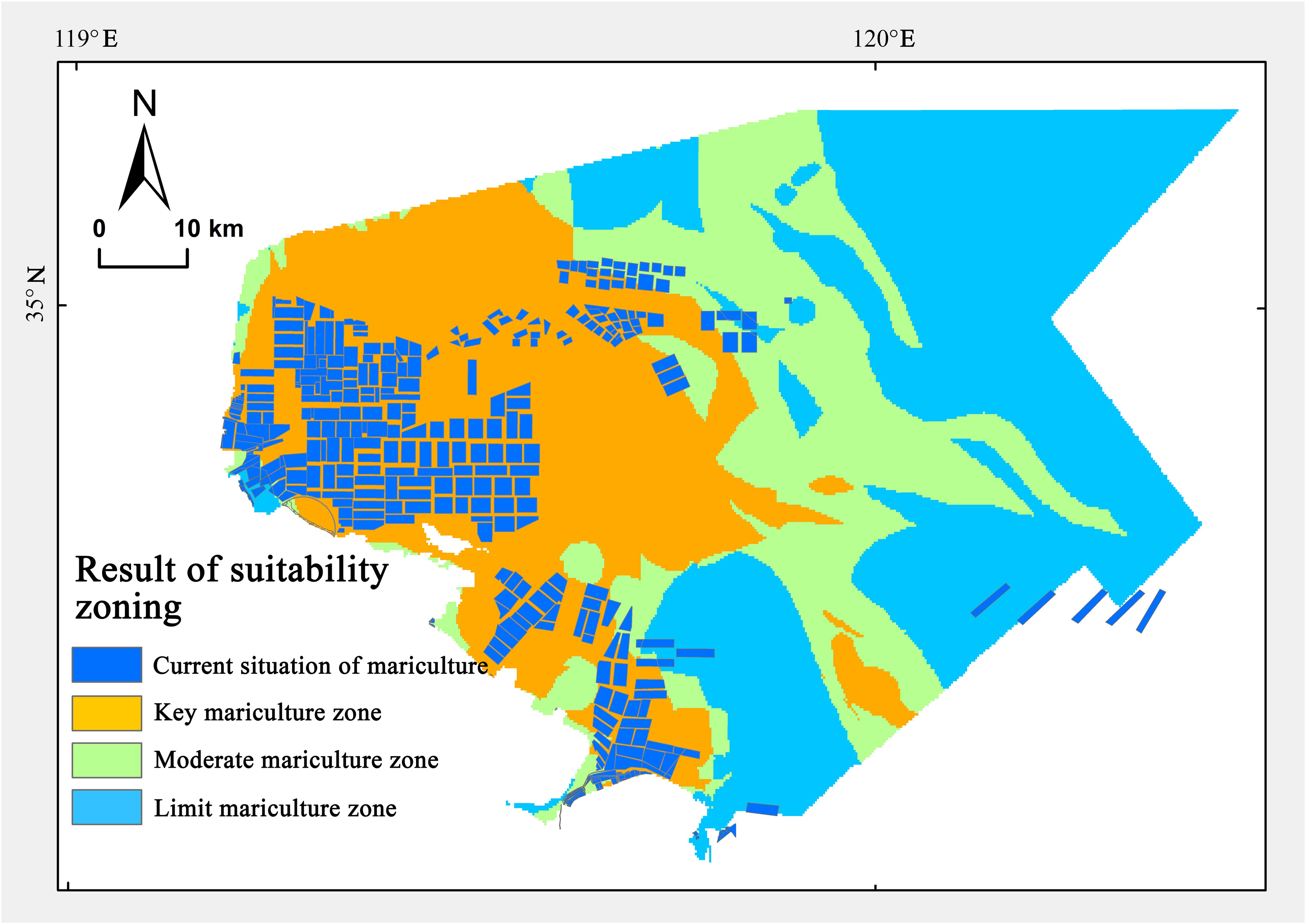
Figure 8. Superimposed map of suitability zoning for mariculture and current situation of mariculture.
However, there are still certain limitations in the selection of indicators and data acquisition in this study. In terms of indicator selection, due to the complex seawater environment, the suitability evaluation of mariculture involves numerous factors, social indexes and suitability assessment criteria of indexes need further practice and improvement in the future. In terms of date, due to the limitations of existing environmental investigation and observation methods, the environmental parameters we have mastered are generally discontinuous in time and space. Therefore, it is necessary to use spatial interpolation to create thematic layers for most environmental parameters. The selection of different interpolation methods may lead to local differences in evaluation results. The production methods of thematic layers for different factors still need to be continuously explored and attempted.
In the future, follow-up research on suitability evaluation should focus more on the scientific nature of evaluation methods and the comprehensiveness of evaluation content. For the weight calculation in traditional evaluation methods, the importance level of influencing factors can also be simulated through growth models related to the breeding objects. Through the continuous improvement of GIS technology and the gradual deepening of understanding of aquaculture organisms and ecological environment, the functions of GIS technology in spatial decision support will be more fully utilized, and there will be better presentation in the evaluation of aquaculture suitability.
5 Conclusions
Marine aquaculture in China has gradually moved towards deep water, and its cultivation areas have slowly expanded. The impact of marine ecological and socio-economic conditions on marine aquaculture is becoming increasingly prominent. To effectively support the management and planning of marine aquaculture, this study establishes an index system to assess the suitability of marine aquaculture by including natural and social perspectives. It evaluates the suitability of marine aquaculture in the Lianyungang sea area, thereby establishing key, moderate, and restricted cultivation areas, and proposes requirements for controlling spatial use. There are two main innovations in this paper. (1) The index system of mariculture suitability assessment was innovatively constructed. In the construction of the index system, we added the influence of social location factors on the location selection of mariculture zones. In the construction of the index system, we added the influence of social location factors on the location selection of mariculture zones. In addition to considering the most basic natural environmental factors, we also increased the influence of social location such as distance from coastline, fishing port and town, so as to further evaluate the mariculture suitability of sea areas from the aspects of social economic pattern and cultural environmental conditions. The inclusion of social and human factors in the suitability evaluation can reflect the relevant trend covering the mariculture development space to a certain extent, and better planning of marine spatial zoning in the region. (2) In the evaluation method, we redesigned the assessment interval and assessment criteria according to the environmental characteristics and the specific performance of various influencing factors of the study area. The characterization scales and calculation methods of different influencing factors were specially treated, and different data processing modes were applied to the relevant monitoring data.
In the future, as Chinese people’s demand for aquatic products increases and restrictions on freshwater aquaculture and marine fishing intensify due to ecological protection, marine aquaculture will be more prominent in enriching food sources and ensuring continued access. Therefore, Lianyungang should use key and moderate mariculture areas to develop marine fisheries, focusing on three effective measures. (1) Stabilizing mariculture areas should be predicated on the existing spatial scale. The determination of this scale must consider factors such as increased production demand, the depletion of ecological resources, and the enhancement of efficient space utilization resulting from technological advancements. By employing scientific methods to determine the appropriate scale for mariculture, healthy mariculture areas can be stabilized, thereby fulfilling the ‘stable growth’ requirements of marine aquaculture products. (2) To optimize the layout of mariculture spaces, it is essential to rigorously control sea use methods and mariculture-related industrial measures. This involves gradually phasing out enclosed mariculture to minimize its negative impact on the marine environment. Concurrently, implementing ecological protection and restoration measures can further reduce mariculture-associated sea use, particularly issues stemming from enclosed mariculture such as spatial conflicts, environmental pollution, and ecological disturbances. (3) Use multiple forms and channels to expand suitable fishing space in deep water offshore, strengthen the security and intensive management of new business spaces such as marine ranches, and further optimize coastal spatial patterns and high-quality marine economic development. This study requires additional research on the approval of spatial zoning for mariculture suitability. It also must consider issues regarding coordination among stakeholders involved in existing regional marine activities, and exclude areas such as port use and ecological protection zones that cannot coexist with mariculture from key and moderate areas.
Data availability statement
The raw data supporting the conclusions of this article will be made available by the authors, without undue reservation.
Author contributions
JG: Project administration, Writing – original draft, Writing – review & editing. JD: Data curation, Visualization, Writing – original draft. TA: Conceptualization, Investigation, Writing – review & editing. XY: Methodology, Resources, Validation, Writing – review & editing.
Funding
The author(s) declare that financial support was received for the research and/or publication of this article. This research was funded by Major Project of Open Fund from Key Laboratory of Ocean Space Resource Management Technology, MNR (KF-2024-103).
Conflict of interest
The authors declare that the research was conducted in the absence of any commercial or financial relationships that could be construed as a potential conflict of interest.
Generative AI statement
The author(s) declare that no Generative AI was used in the creation of this manuscript.
Publisher’s note
All claims expressed in this article are solely those of the authors and do not necessarily represent those of their affiliated organizations, or those of the publisher, the editors and the reviewers. Any product that may be evaluated in this article, or claim that may be made by its manufacturer, is not guaranteed or endorsed by the publisher.
References
An T. T., Gao J. Z., Li J. (2022). Functional zoning of coastal zone based on land-sea coordination -A case study of Ningbo. Mar. Sci. Bull. 41, 315–324. doi: 10.11840/j.issn.1001-6392.2022.03.008
Beard K., Kimble M., Yuan J., Evans K., Liu W., Brady D., et al. (2020). A method for heterogeneous spatio-temporal data integration in support of marine aquaculture site selection. J. Mar. Sci. Eng. 8, 96. doi: 10.3390/jmse8020096
Cadee C. (1975). Primary production off the Guyana coast. Netherlands J. Sea Res. 9, 128–143. doi: 10.1016/0077-7579(75)90027-7
Chen L., Li F., Lin J., Gao Y., Zhang X. (2023). Port shoreline suitability evaluation under the constraints of sea area use management policy: A case study of the Pearl River Estuary and Dapeng Peninsula. Sci. Technol. Rev. 41, 97–103. doi: 10.3981/j.issn.1000-7857.2
Cheng H., Zhong J. X., Zhou Y., Ai B., Feng W. J. (2024). Suitability evaluation of offshore sea sand mining based on subjective and objective weighting method. Mar. Geology Front. 40, 53–61. doi: 10.16028/j.1009-2722.2023.216
Drackett L., Dragićević S., Salomon A. K. (2023). Integrating multiple perspectives in marine spatial planning using the GIS-based Logic Scoring of Preference method. Ocean Coast. Manage. 232, 106423. doi: 10.1016/j.ocecoaman.2022.106423
Fast D. E., Pagen F. A. (1974). “Comparative observations of an artificial tire reef and natural patch reefs off southwestern Puerto Rico,” in Proceedings, artificial reef conference. Eds. Colunga L., Stone R. (America: Texas A &M Univ), 49–50.
Fei J. H., Wang Z. W., Chen P. X., Wang X., Ye G. Q. (2023). Analysis of multi-suitability of sea area development in zhejiang province. Ocean Dev. Manage. 40, 72–78. doi: 10.20016/j.cnki.hykfygl.2023.02.010
Feng J. N., Liu R. J., Pu L. J., Qie L., Zhu M. (2022). Suitability evaluation of territorial spatial development from the perspective of land- sea coordination: A case study of Nantong City, China. Resour. Sci. 44, 299–308. doi: 10.18402/resci.2022.02.07
Fu J., Bu Z., Jiang D., Lin G., Li X. (2022). Sustainable land use diagnosis based on the perspective of production–living–ecological spaces in China. Land Use Policy 122, 106386. doi: 10.1016/j.landusepol.2022.106386
Gao J. Z., An T. T., Shen J. W., Zhang K. C., Yin Y., Zhao R., et al. (2022). Development of a land-sea coordination degree index for coastal regions of China. Ocean Coast. Manage. 230, 91–103. doi: 10.1016/j.ocecoaman.2022.106370
Gao J. Z., An T. T., Zhang H. F., Zhang K. C., Shen J. W., He G. S., et al. (2023a). The evaluation method of the marine spatial suitability for islands from the perspective of sustainable development: A case study of the pingtan islands. Sustainability 15, 8996. doi: 10.3390/su15118996
Gao J. Z., Ding J., Gu X. Y., Li G. Q., Yang X., Sun M., et al. (2024a). Developing ecological restoration strategies based on carbon storage assessment. J. Sea Res. 202, 202102539–102539. doi: 10.1016/j.seares.2024.102539
Gao J. Z., Zhang K. C., He G. S., TIan S. Z., Zhao Y. H. (2023b). Study on the suitability of small-scale marine spatial planning—using Jinpu new district, Dalian as an example. Trans. Oceanology Limnology 45, 164–173. doi: 10.13984/j.cnki.cn37-1141.2023.01.022
Gao W. M., Song Q., Zhang H. X., Tian S. Z., Zhao Y. H. (2024b). Selection of priority conservation areas based on ecosystem service functions and wildlife habitat suitability evaluation: A case study in the sanjiang-yuan region. Ecol. Environ. Sci. 33, 1318–1328. doi: 10.16258/j.cnki.1674-5906.2024.08.016
Gu Y., Tian P., Xie Z. Y., Huang J. L., Lin L. P. (2022). Dynamic evaluation of land development suitability of uninhabited islands - a case study in Dayu island in Pingtan, Fujian province. Mar. Environ. Sci. 41, 208–214. doi: 10.13634/j.cnki.mes.2022.02.007
Han W. S., Chen X. J., Niu X. N., Li Z., Sheng D. Y. (2023). Habitat suitability assessment based on GIS spatial analysis and conservation suggestions for ecological source areas in Huizhou. J. Huizhou Univ. 43, 57–63. doi: 10.16778/j.cnki.1671-5934.2023.06.010
Huang J., Huang X. L., Song N. Q., Ma Y., Wei D. (2022a). Evaluation of the spatial suitability of offshore wind farm—A case study of the sea area of liaoning province. Sustainability 1, 449–449. doi: 10.1016/j.renene.2015.01.041
Huang P., Sun Y. G., Chen Y., Wang Z. C., Wang E. K. (2022b). Suitability evaluation method and application for seawater desalination intake site selection. Adv. Mar. Sci. 40, 523–535. doi: 10.12362/j.issn.1671-6647.20210630001
Huang S. N., Chen Y. P., Feng X. S., Qiao T. T., Yu D. D., Yang Y. Q., et al. (2022c). Research on dynamic assessment method of earthquake scene rescue performance based on AHP and cloud model. Mathematic. 10, 207. doi: 10.3390/MATH10020207
Jin J. F., Yin S. Y., Yin H. M., Bai X. (2023). Eco–environmental effects of “Production–Living–Ecological” space land use changes and recommendations for ecological restoration: A case study of the weibei dryland in Shaanxi Province. Land 12 (5), 1060. doi: 10.3390/LAND12051060
Jing S. Y., Fu G. X., Zhou Z., Zhao L., Zhang P. T. (2024). The recognition and optimization study on the dominant agricultural space in Cangzhou based on the suitability evaluation of agricultural production. Front. Sustain. Food Syst. 8, 81434214. doi: 10.3389/fsufs.2024.1434214
Latinopoulos D., Kechagia K. (2015). A GIS-based multi-criteria evaluation for wind farm site selection. A regional scale Appl. Greece. Renewable Energy 78, 550–560. doi: 10.1016/j.renene.2015.01.041
Lei F., Chen X. Y., Zhang R. C., Zhuang J. L., Ke K. S. (2014). Application the nemerow index to comprehensive assessment of sea area environmental quality of beibu gulf coast in summer. Guangxi Sci. 21, 84–88. doi: 10.13656/j.cnki.gxkx.2014.01.014
Li W., Chen Z. J., Li M. C., Zhang H., Li M. Y., Qiu X. Q., et al. (2023). Carbon emission and economic development trade-offs for optimizing land-use allocation in the Yangtze River Delta, China. Ecol. Indic. 147, 109950. doi: 10.1016/j.ecolind.2023.109950
Li C. L., Liu Y., Yin Z. X., Si Q. Z., Li Q., Saitoh S. I. (2024). Evaluation of the Pacific oyster marine aquaculture suitability in Shandong, China based on GIS and remote sensing. Front. Mar. Sci. 11. doi: 10.3389/fmars.2024.1402528
Li Q. S., Huang J. L., Wang C., Wang B. K., Wu Y. J., Zhang J. W., et al. (2017). Assessment of the Pingtan Island land development suitability based on comprehensive ecological–economic–industrial analysis. Mar. Sci. 41, 1–10. doi: 10.11759/hykx20160722001
Li Y. F., Zhang Q., Xiang Z. Y., Zhang Z. (2022). Evaluation of marine space development suitability based on ecosystem service: A case study of Lingdingyang Bay of Guangdong-Hong Kong-Macao Greater Bay Area. J. Of Natural Resour. 37, 999–1009. doi: 10.31497/zrzyxb.20220411
Lin Y., Liu S. X., Guan D. M., Zhang Z. D., Wen Q. (2014). GIS-based Japanese scallop (Patinopecten yessoensis) aquaculture suitability assessment: a case study with the islands of Dachangshan and Xiaochangshan. North Yellow Sea, China. Acta Ecologica Sin. 34, 5984–5992. doi: 10.5846/stxb201301250158
Liu C., Yang M. H., Hou Y. T., Xue X. Z (2021). Ecosystem service multifunctionality assessment and coupling coordination analysis with land use and land cover change in China’s coastal zones. Sci. Total Environ. 797, 149033. doi: 10.1016/J.SCITOTENV.2021.149033
Liu B. L., Zhang Z. K., Ji X. P., Jiang S. N., Wei G. N., Zhou K. X., et al. (2022). Research on suitability evaluation of land space development and functional space allocation in coastal zone: A case study of Hainan Island. J. Natural Resour. 37, 862–879. doi: 10.31497/zrzyxb.20220403
Liu S. H., Zhao L. L., Liu W., Wang B., Zhang C. H. (2019). The assessment of carrying capacity of marine biology resources based on primary productivity method – A case study of coastal waters of Rizhao. Haiyang Xuebao 41, 121–133. doi: 10.3969/j.issn.0253–4193.2019.12.012
Luo T. (2023). Suitability Evaluation and development of cultivated land reserve resources based on ecological sensitivity in Yuanzhou Distric (China: Jiangxi Agricultural University), 20–55. doi: 10.27177/d.cnki.gjxnu.2023.000060
Lv T. Y., Zeng C., Lin C. X., Liu W. P., Cheng Y. J., Li Y. B. (2023). Towards an integrated approach for land spatial ecological restoration zoning based on ecosystem health assessment. Ecol. Indic. 147, 110016. doi: 10.1016/J.ECOLIND.2023.110016
Ma R. F., Ji S. W., Ma J. W., Zhu B. Y., Ren L. Y., Shao Z. H. (2022). The practice and application of”Dual evaluation”in marine areas:A case of wenzhou. Economic Geogr. 42, 21. doi: 10.15957/j.cnki.jjdl.2022.01.003
Ma J. Y., Qu C. X., Du X. H., Yang Y. M., Liu B. Y. (2024). Suitability evaluation and location-allocation optimization of disaster shelters based on GIS: A case study in Rizhao of Shandong Province. J. Natural Disasters 33, 106–117. doi: 10.13577/j.jnd.2024.0410
Qin M. G., Yang C. Y., Huang S. R., Zhu C. Q., Tong C. L., Long G. Y., et al. (2022). Suitability evaluation of the exploitation and utilization of marine sand resources for construction:Taking the east exit of Qiongzhou Strait as an example. Bull. Geological Sci. Technol. 41, 249–258. doi: 10.19509/j.cnki.dzkq.2021.0065
Qiu M., Zhang Y., Sui C. G., Yang P. F. (2018). Suitability evaluation of deep-water cage aquaculture based on GIS——taking Changhai County as an example. J. Fisheries Res. 40 (6), 449–457. doi: 10.14012/j.cnki.fjsc.2018.06.005
Qu Y. B., Wang S. L., Tian Y. Y., Jiang G. H., Zhou T., Meng L. (2023). Territorial spatial planning for regional high-quality development – An analytical framework for the identification, mediation and transmission of potential land utilization conflicts in the Yellow River Delta. Land Use Policy 125, 110016. doi: 10.1016/j.landusepol.2022.106462
Rong L. H., Li Y. T. (2023). Suitability evaluation and zoning of livestock production under the background of national land space planning: A case of Xianghuang Banner of Xilin Gol League. Arid Land Geogr. 46, 1166–1175. doi: 10.12118/j.issn.1000-6060.2022.549
Santjer R., Mares-Nasarre P., Vilmin L., El Serafy G. Y. H., Nápoles O., Morales. (2024). A probabilistic framework for offshore aquaculture suitability assessment using bivariate copulas. Aquacultural Eng. 107, 102479. doi: 10.1016/J.AQUAENG.2024.102479
Sathiyamurthi S., Saravanan S., Karuppannan S., Balakumbahan R., Sivasakthi M., Praveen Kumar S., et al. (2024). Agricultural land suitability of Manimutha Nadhi watershed using AHP and GIS techniques. Discover Sustainability 5, 270–270. doi: 10.1007/s43621-024-00471-4
Shao H. Q., Zhang Y. W., Qu C., Li W. H., Zhao Y. J., Liu N., et al. (2020). Analysis of heavy metal contamination in the soil and enrichment capabilities of terrestrial plants around a typical vanadium smelter area. Chin. J. Eng. 42, 302–312. doi: 10.13374/j.issn2095-9389.2019.04.23.001
Shi J. G., Wang L. M., Xu J. Z., Hu Z. H., Liu Y. L., Jiang Z. M., et al. (2008). Preliminary study on the site selection of deep water net cage. Modern Fisheries Inf. 02), 9–12 + 22. doi: 10.3969/j.issn.1004-8340.2008.02.002
Silva C., Ferreira J., Bricker S., DelValls T., Martín-Día M., Yáñez E., et al. (2011). Site selection for shellfish aquaculture by means of GIS and farm-scale models, with an emphasis on data-poor environments. Aquaculture 318 (3), 444–457. doi: 10.1016/j.aquaculture.2011.05.033
Standardization Administration of the People’s Republic of China (1997). “GB 3097—1997,” in Sea water quality standard (China: Ministry of Ecology and Environment of the People's Republic of China).
Sun P., Shi Y. Q. (2024). The location selection of forest health care bases in taiyuan city based on GIS suitability evaluation. Issues Forestry Economics 44, 198–208. doi: 10.16832/j.cnki.1005-9709.20230314
Suo A., Zhou W., Ding D. (2023). Suitability evaluation on marine ranching in Guangdong, South China. J. Oceanology Limnology 41, 778–791. doi: 10.1007/s00343-022-1423-8
Thomas L. R., Clavelle T., Klinger D. H., Lester S. E. (2019). The ecological and economic potential for offshore mariculture in the Caribbean. Nat. Sustainability 2, 62–70. doi: 10.1038/s41893-018-0205-y
Vasileiou M., Loukogeorgaki E., Vagiona D. G. (2017). GIS-based multi-criteria decision analysis for site selection of hybrid offshore wind and wave energy systems in Greece. Renewable Sustain. Energy Rev. 73, 745–757. doi: 10.3390/su14010449
Wu X. Z. (2023). Construction suitability evaluation and layout planning strategies of Xiamen bathing beach. J. Subtropical Resour. Environ. 18, 130–138. doi: 10.19687/j.cnki.1673-7105.2023.04.016
Wu J. P., Zhang H. B., Pan Y. W., Krause-Jensen D., He Z. G., Fan W., et al. (2020). Opportunities for blue carbon strategies in China. Ocean Coast. Manage. 194, 105241. doi: 10.1016/j.ocecoaman.2020.105241
Xiang Y. Y., Yang H., Chen P. X., Zhou X., Chen Q. Z., Zeng J. N. (2018). Management of marine ecosystem based on ecological suitability assessment with a case study in Dongtou district, Wenzhou city. J. Appl. Oceanography 37, 551–559. doi: 10.3969/J.ISSN.2095-4972.2018.04.011
Xu Y., Bao C. G., Liang B., Lan D. D., Zhu R. J., Yu C. Y., et al. (2016). Suitability evaluation of artificial reefs site selection in Tianjin offshore waters area. Mar. Environ. Sci. 35, 846–852 + 867. doi: 10.13634/j.cnki.mes.2016.06.008
Xu M. H., Lin X. R., Wen C. X., Liu X. (2024). Research on land use suitability evaluation and layout optimization in coastal zones: vulnerability assessment based on the nature-social economy. South Architecture 5), 106–115. doi: 10.3969/j.issn.1000-0232.2024.05.011
Yang Y. J., Li H. Y., Qian C. (2023). Analysis of the implementation effects of ecological restoration projects based on carbon storage and eco-environmental quality: A case study of the Yellow River Delta, China. J. Environ. Manage. 340, 117929. doi: 10.1016/J.JENVMAN.2023.117929
Yi R., Yan H., Qi M., Zhang Z., Dong Z. Y., Wang Y., et al. (2024). Suitability evaluation of urban underground space development based on urban planning. Geology Explor. 60, 339–347. doi: 10.12134/j.dzykt.2024.02.011
Yin H. W., Kong F. H., Luo Z. D., Yan W. J., Sun C. F., Xu F. (2013). Suitability assessment of construction land in the central and southern parts of Hebei Province, China based on potential-limitation model. Chin. J. Appl. Ecol. 24, 2274–2280. doi: 10.13287/j.1001-9332.2013.0386
Yu L., Jiang Q. J. (2024). The impact of heterogeneous environmental regulation on the green development of fisheries in China. Scientia Geographica Sin. 44, 319–328. doi: 10.13249/j.cnki.sgs.20220960
Yuan J., Ye F., Cang F., Liu D. (2021). The utilization status and suitability evaluation of dongtou island coastline. Zhejiang Land Resour. S1), 6–12. doi: 10.16724/j.cnki.cn33-1290/p.2021.s1.003
Zhang X. H., Liu H. Z., Li J. J., Wang C. L., Wang Y. N., Liu D., et al. (2019). Water quality evaluation in aquaculture area of Zhonglu Island in the East China Sea based on improved Nemerow index evaluation method. J. Appl. Oceanography 38, 225–231. doi: 10.3969/J.ISSN.2095-4972.2019.02.009
Zhang Z. N., Wang Z. Y., Li G. H., Zhao M. H. (2023). Evaluation method for site selection suitability of artificial reef areas based on analytic hierarchy process. Oceanologia Et Limnologia Sin. 54, 1308–1321. doi: 10.11693/hyhz20230200026
Zhang Y. H., Wang Z. Y., Wu X. Q., Cui B. L. (2024). Spatial optimization of agricultural and fishery utilization in coastal tidal flats based on suitability and ecological network. J. Agric. Resour. Environ. 41, 794–806. doi: 10.13254/j.jare.2023.0542
Keywords: mariculture, suitability assessment, Lianyungang, marine spatial planning, GIS
Citation: Gao J, Ding J, An T and Yang X (2025) Research on mariculture suitability assessment based on GIS – a case study of sea area in Lianyungang. Front. Mar. Sci. 12:1518897. doi: 10.3389/fmars.2025.1518897
Received: 29 October 2024; Accepted: 28 March 2025;
Published: 28 April 2025.
Edited by:
Song Ding, Zhejiang University of Finance and Economics, ChinaReviewed by:
Yixiong He, Zhejiang Ocean University, ChinaMan Qin, Ocean University of China, China
Hao Kong, Fujian Institute of Oceanography, China
Copyright © 2025 Gao, Ding, An and Yang. This is an open-access article distributed under the terms of the Creative Commons Attribution License (CC BY). The use, distribution or reproduction in other forums is permitted, provided the original author(s) and the copyright owner(s) are credited and that the original publication in this journal is cited, in accordance with accepted academic practice. No use, distribution or reproduction is permitted which does not comply with these terms.
*Correspondence: Xiao Yang, NzQyODg2MzU2QHFxLmNvbQ==; Jinzhu Gao, Z2Fvamluemh1MDkzNEAxNjMuY29t