Abstract
Introduction:
Human socioeconomic activities flourish in coastal zones, and the rational use and protection of spatial resources and environments are vital for the sustainable development of coastal cities. To promote optimal resource allocation across ecological, residential, and production spaces (hereafter referred to as the “triple space”), an investigation into their functional coupling coordination is crucial for optimizing the allocation of ecological, living, and production space resources.
Methods:
In this study, we developed an evaluation index system encompassing multiple aspects such as ecological supply and purification, residential security, and production supply. We constructed coupling coordination degree models for the triple space to quantitatively measure pairwise functional coupling and overall coordination in the coastal zone of Ningbo. Spatial characteristics and evolution patterns were analyzed using global and local Moran indexes. We analyzed the overall variation in functional coupling coordination across the coastal zone of Ningbo and correlations among evaluation units.
Results:
The findings are summarized as follows: First, a cross-coupling relationship exists with coupling coordination degrees ranging from 0.21 to 0.66 across the coastal zone of Ningbo, showing significant spatial variation (high in the south and north and low in the middle), with local coordination centers in Cixi City and Xiangshan County. Coupling coordination generally increased from 2000 to 2020. Secondly, pairwise functional coupling coordination varies, with relatively low coordination between ecology and residential areas, increasing coordination between ecology and production, and rapidly rising coordination between residential and production areas, which is currently at high levels. Third, the coupling coordination degree exhibits an overall random spatial distribution pattern without distinct clustering or discrete effects.
Discussion:
According to the local Moran index, land and sea areas of Yinzhou District show high-value polarization, failing to drive surrounding development; Zhenhai and Beilun districts exhibit low-value clustering with potential for optimization; and Cixi City and Ninghai County are high-value clustering areas, indicating strong coupling coordination. This study provides a new approach for exploring the intrinsic relationship between the different triple space functions in coastal zones and valuable reference for policy formulation and planning.
1 Introduction
Situated at the interface of the land and sea, coastal zones encompass both terrestrial and marine ecosystems and are rich in natural, ecological, transportation, and tourism resources. They play a crucial role in promoting socioeconomic development, ensuring resource security, and regulating the ecological environment. However, rapid and uncontrolled economic growth, population expansion, and urbanization in the coastal regions of China over recent decades have resulted in the degradation of arable land, vegetation, mudflats, and wetlands (Liu et al., 2014; Jones et al., 2018). This has intensified the conflict between human activities and the natural environment, leading to resource depletion, ecological imbalance, severe soil erosion, and frequent natural disasters; therefore, achieving a harmonious balance between development, habitation, and environmental protection is paramount (Xu et al., 2016). The promotion of functional coupling and coordinated management of ecological, residential, and productive spaces—referred to as “triple space”—within coastal zones is central to this goal. This concept underscores the need for integrated and sustainable development practices to ensure both the health and orderly growth of these regions. Consequently, the management and conservation of national spatial resources have emerged as critical areas of research interest.
Of the three functions referred to in triple space (primarily ecological products and ecological services), ecological functions are related to the essential property of a natural resource, serve as the prerequisite and control the development direction for the living and production functions, acting as a constraint (Chen and Shi, 2005). Living functions mainly refer to residence, consumption, recreation, and entertainment (Sun et al., 2017), and production functions refer to the use of land to obtain various products and services (Wang and Dong, 2015). The triple space is functionally interrelated and interacts via a logical relationship; thus, constituting a holistic system (Li et al., 2018).
Early studies investigating national land space do not mention the concept of “triple space”, nor investigate the triple space of the coastal zone. However, the “Green Belt” planning of UK (Wang and Zhang, 2003) and the “Urban Growth Boundary” of the US (Fan and Li, 2009) embody a similar principle. From the perspectives of multi-purpose land use and ecology, subsequent studies included the land use decision-making process (Koomen et al., 2008), sustainable development prediction and analysis (Ghaderi and Henderson, 2012), planning management (Hersperger et al., 2018), and land use and ecological effects (Nelson et al., 2009), to promote the coordinated development of cities and the environment. Existing studies examining the triple space predominantly concern China, a country in which the national land space must be optimized owing to its rapid urbanization, which aggravated the human-land contradiction. Hence, concepts such as “triple space” have become a focus for research, with domestic studies mainly focusing on connotation analysis, spatial function identification, and spatial division evaluation on national (Liu and Sun, 2020), provincial (Chen et al., 2020), and city (Wu et al., 2016) scales over the last two decades. In terms of evolution, domestic researchers mainly use the spatial autocorrelation model (Cui et al., 2018), GeoDetector (Lu et al., 2022), and the landscape ecological risk index (Xia et al., 2023) to examine the quantitative structure and spatial structure characteristics of the triple space, while its optimization is generally examined using methods such as multi-factor evaluation based on suitability (Wei et al., 2021), spatial effect and trend simulation analysis (Jin et al., 2013), and spatial supply-demand coupling analysis based on the ecological niche (Meng et al., 2011). Most studies investigating the triple space function focus on a single type of function, with qualitative analysis of the relationship between the different regional space functions performed by identifying and evaluating the functions of regional space and analyzing their spatiotemporal evolution characteristics (Hong et al., 2017). However, few studies quantitatively analyzed the relationship between different triple space functions and the inherent evolution pattern, and none comprehensively examined the coordinated development of different triple space functions using a nature-economy-society-ecology comprehensive evaluation system (Zhang and Zhai, 2020). The coupling coordination degree model (Zhang et al., 2016), which can evaluate the degree of interaction and coordination between two or more systems, was applied in diverse fields, such as ecological environments and resource development (Xiong et al., 2014), transportation and urban development (Yuan et al., 2019), land use and socio-economy (Huang et al., 2017; Zhang et al., 2017), tourism and agriculture (Fleischer and Tchetchik, 2005), urban and rural development (Wang et al., 2017; Yang et al., 2022), and ecosystems and landscapes (Gulickx et al., 2013). This model could therefore provide an important reference for evaluating the triple space functions in coastal zones.
Ningbo is a major economic center that lies south of the Yangtze River Economic Belt and is a major node in the “One Belt and One Road” region. The rapidly increasing population in the area has led to accelerated industrialization and urbanization, resulting in the rapid evolution of the triple space functions in the zone. Thus, in this study, the districts, cities, and counties of the coastal zone of Ningbo were used as evaluation units and an evaluation index system was created to characterize the triple space functions in the zone. A functional coupling model for the triple space was then constructed to calculate the functional coupling and coupling coordination degrees of the triple space and analyze the spatiotemporal variation and evolution pattern of the coupling coordination degree. Our findings are expected to provide a new approach and act as a reference for exploring the intrinsic relationship between the different triple space functions in coastal zones, promote the coordination of the functions, and ultimately optimize the spatial pattern of the coastal zone.
2 Data and methods
2.1 Study area
Ningbo is located northeast of Zhejiang Province and south of Hangzhou Bay, with geographic coordinates of 29°01’ to 30°24’N and 120°50’ to 122°11’E. Ningbo is dominated by a sub-tropical monsoon climate with four distinct seasons, moderate climate, plentiful rainfall, high terrain in the southwest and low terrain in the northeast, and abundant marine resources. Ningbo is a globally known port city and is the core demonstration area for the development of the marine economy in Zhejiang Province, and a major metropolitan area demonstrating the coordinated development of the Yangtze River Delta city group. The coastal zone of Ningbo covers a total area of 12 069.91 km2, of which land and sea areas comprise 4696.35 km2 (38.91%) and 7373.56 km2 (61.09%), respectively.
In this study, the coastal zone of Ningbo refers to the sea area between the central axis (i.e., Ningbo’s coastline) and the outer boundary specified in marine functional zone promulgated by China in 2012 and the land at least 5 km away from the central line that is bounded by the administrative boundaries of its coastal villages and towns (Figure 1). Specifically, the coastal zone of Ningbo includes Yuyao and Cixi cities; Zhenhai, Beilun, Yinzhou, and Fenghua districts; and Ninghai and Xiangshan counties (as shown in Figure 1).
Figure 1
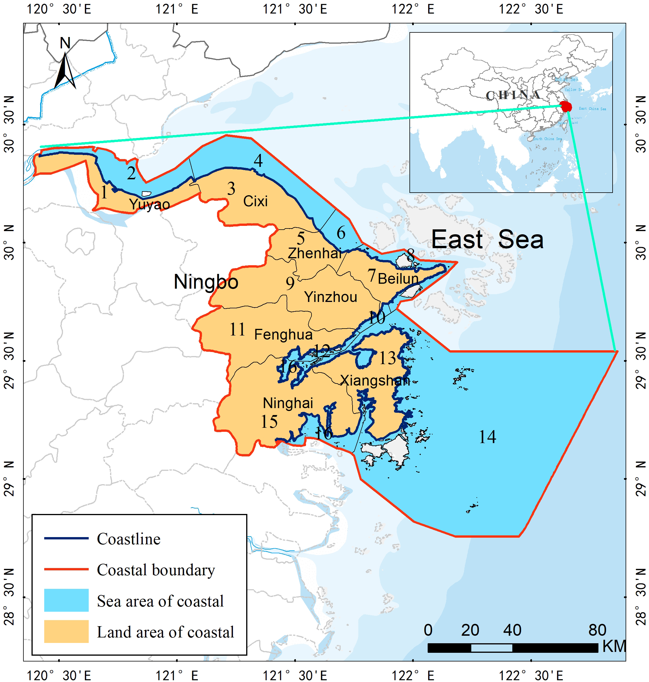
Schematic diagram of the study area. Sea and land areas associated with Yuyao and Cixi Cities, Zhenhai, Beilun, Yinzhou, and Fenghua Districts, and Ninghai and Xiangshan Counties are numbered from 1 to 16, respectively.
2.2 Data sources and processing
Following the Technical Regulations on Land Resource Survey and Classification System for Sea Area Use, land and sea area use data were extracted from satellite images using an object-oriented method (e.g., multiresolution segmentation, subordinating degree function, and standard nearest neighbor classification) (Luo et al., 2013; Wang et al., 2014). Satellite data were obtained from the Landsat and HJ series (Spatial resolution 30m); specifically, the Landsat series data from the official website of the United States Geological Survey (http://www.usgs.org/), and the HJ series data from the official website of the China Center for Resources Satellite Data and Application (http://www.cresda.com/CN/) were utilized. Industrial agglomeration data were vectorized according to Ningbo’s Planning on Key Industrial Agglomeration Areas (2000–2020). Geological hazard data were synthesized and digitized according to the Geological Hazards Planning (2000–2020) and Distribution Map on Hidden Geological Hazards issued by the Ningbo Bureau of Natural Resources and Planning. Environmental disaster data were provided by the Ningbo Environmental Monitoring Center. Data concerning nature reserves were acquired from the Ministry of Ecology and Environment of the People’s Republic of China. The ecological red line data were vectorized according to Ningbo’s Program on Ecological Red Line Delineation and Ningbo’s Program on Marine Ecological Red Line Delineation. the coastal socioeconomic data of Ningbo (including GDP per capita, educational resources, medical resources per capita, and transportation accessibility) were obtained from the Social and Economic Statistics Yearbook issued by Ningbo Municipal Statistics Bureau (http://tjj.ningbo.gov.cn). Water quality data were obtained from the Bulletin on China’s Ecological Environment Status released by the Ministry of Ecology and Environment of the People’s Republic of China, and field measurements. The vector and raster data coordinates used were based on CGCS2000 and Gauss-Kruger projection.
2.3 Methodology
Based on the theory of triple space for the spatial planning of national land and existing studies, the spatial functions of the coastal zone were classified as the triple space. Considering that coastal zones are affected by diverse factors, such as natural conditions, resource endowment, and socioeconomic development of land and sea areas, functional coupling evaluation index systems describing the triple space were constructed for the land and sea areas of the coastal zone Ningbo, and functional coupling and coupling coordination degree models constructed based on related data describing the zone (e.g., high-resolution remote-sensing images, land use, sea area use, ecological environment factors, natural environment disasters, and socioeconomic development). The functional coupling degree and coupling coordination degree for the land and sea spaces comprising the coastal zone were then calculated, the spatial variation evolution trend of the pairwise functional coupling of triple space in the coastal zone was analyzed, and the overall variation in the functional coupling coordination degree and similarity between local adjacent units finally discussed in terms of the global and local Moran indices. A flowchart of the methods used is shown in Figure 2.
Figure 2
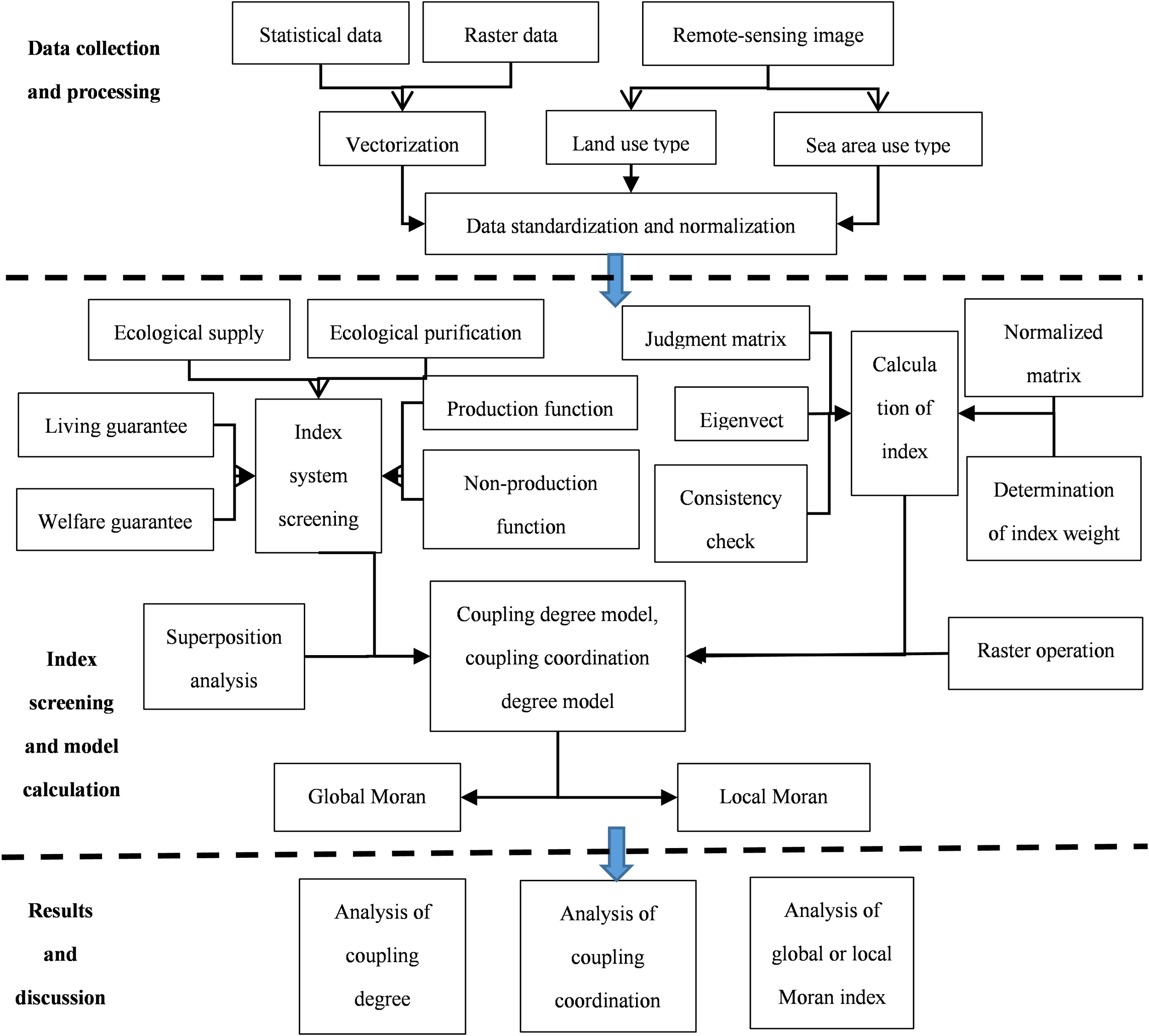
Flowchart showing functional coupling of triple space in the coastal zone. To promote optimal resource allocation across ecological, residential, and production spaces in the sea area, the evaluation index system and functional coupling model were constructed, and the spatial characteristics and evolution patterns were analyzed using global and local Moran indexes.
2.3.1 Determination of the evaluation units
Based on data characteristics, the evaluation units used for functional coupling of the triple space in the coastal zone of Ningbo were classified into type and administrative. Land- and sea area-use types and vectorized disaster data were extracted from remote sensing images, complete ground feature units were used for evaluation, and the corresponding district- or county-level administrative areas were used for the evaluation of economic, human, and social data on district or county scales. The different types of evaluation units were converted to a unified scale and then spatial overlay operations were performed for the evaluation of the functional coupling and coupling coordination degrees of the triple space.
2.3.2 Creation of the evaluation index system and index weight calculation
The coastal zone of Ningbo includes three types of land and sea space (i.e., ecological, living, and production). Owing to the differences between the land and sea areas in terms of geographic location, natural conditions, resource endowment, and development types, different evaluation indices were selected for land and sea, for which relevant literature and experts in the fields of land, geography, and oceanology were utilized, and the availability and stability of index data describing the study area were considered. The functional coupling evaluation index system for the triple space covers diverse aspects (e.g., ecological supply, ecological purification, life guarantee, welfare guarantee, production function, and non-production function), with 19 indices for land and 17 indices for sea (as described in Table 1). As the functional coupling evaluation index system comprised multiple indices for both land and sea, the weights of the evaluation indices were calculated using the entropy value and analytic hierarchy process (APH) methods, and the optimal combined weights were determined using the optimal combined weighting model (Jia and Liang, 2018). This method fully considers both subjective experience and objective data, rendering the calculation results more scientific and reliable.
Table 1
| Triple Space of Coastal Zone | Criterion Layer | Index Layer | |||
|---|---|---|---|---|---|
| Land area | Weight | Sea area | Weight | ||
| Ecological function | Ecological supply | Vegetation coverage | 0.17 | Sea water quality | 0.15 |
| Wetland area | 0.17 | Proportion of natural coastline | 0.14 | ||
| Proportion of natural reserves | 0.29 | Marine reserve area | 0.16 | ||
| Water area | 0.19 | Marine biodiversity | 0.13 | ||
| Ecological purification | Landslide frequency | 0.03 | Frequency of red tide and storm surge | 0.09 | |
| Soil salinization | 0.03 | Oil spillage | 0.08 | ||
| Per-capita industrial pollution emissions | 0.07 | Discharge of industrial waste into the sea | 0.13 | ||
| Per-capita agricultural and fishery pesticide usage | 0.05 | Discharge of domestic waste into the sea | 0.12 | ||
| Living function | Life guarantee | Per-capita income | 0.26 | Sea area occupied in urban settlements | 0.1 |
| Urban-rural construction ratio | 0.13 | Terminal passenger traffic | 0.18 | ||
| Transportation accessibility | 0.13 | | | ||
| Welfare guarantee | Proportion of the educated population | 0.26 | Beach area | 0.26 | |
| Tourism resource density | 0.1 | Proportion of marine tourism facilities | 0.46 | ||
| Number of hospitals | 0.12 | | | ||
| Production function | Production function | Industrial park size | 0.29 | Port throughput | 0.27 |
| Per-capita arable land area | 0.13 | Aquiculture area | 0.1 | ||
| Urban employment rate | 0.26 | Marine economy size | 0.25 | ||
| Non-production function | Hinterland influence | 0.15 | Sea area activity | 0.16 | |
| Population agglomeration | 0.17 | Sea reclamation area | 0.22 | ||
Evaluation indices and weights used in the functional coupling of the triple space in the coastal zone of Ningbo.
2.3.3 Standardizing the index data
The data used in the functional coupling evaluation indices included both statistical text (social and economic statistics) and vector (land and sea area use statuses, protected reserve, and red line area) data; thus, the units and orders of magnitude varied, which implied that standardization was required. The functional coupling evaluation data were standardized via 1) graded assignment for seawater quality and natural environmental disasters data; 2) normalization for resources, environment, and socioeconomic data (Equations 1, 2); and 3) distance decay and buffer analysis for transportation accessibility and tourism resource density data (Equation 3).
The equation for the negative index is as follow:
where denotes the value of the j-th index in factor i (unit), denotes the j-th index in factor i, denotes the maximum value of the j-th index, and denotes the minimum value of the j-th index.
where denotes the value of the j-th index in factor i (object), k denotes the coefficient of the evaluation index object, d denotes the influence radius of the evaluation object, and D denotes the distance between the evaluated area and the evaluation object.
2.3.4 Creation of the coupling model
The interaction between the triple space functions in a coastal zone not only reflects the diverse development needs of stakeholders but is also a dynamic process that includes the quantitative and spatial redistribution of scarce land resources across the triple space, while also reflecting the socioeconomic characteristics of the coastal zone at different stages. This interaction thus has a considerable impact on the spatial development and evolution of the coastal zone. Ecological space, as the resource and environmental background of a zone, guarantees production and living functions. The production space serves as the foundation for the zone and can provide an economic and material guarantee for its living functions; however, increasing the scope and intensity of production activities can lead to severe damage to the coastal zone environment and degradation of its ecological functions. Living space is the daily living and social needs of residents in the zone, supplementing its production functions. Expanding the living space leads to pollution from excessive human activities and restricts the implementation of ecological functions. The triple space of a coastal zone thus exhibits a coupled and interactional relationship manifested as mutual promotion and coercion. In this study, functional coupling and coupling coordination were introduced to construct a functional coupling model for the triple space of the coastal zone, allowing exploration of the mutual promotion and coercive relationship between the triple space functions within the zone. The functional coupling degree of the triple space in a coastal zone is expressed using the following equation:
where R denotes the functional coupling degree of the triple space and reflects the interaction intensity and the mutual influence between the triple space functions. The larger its value, the more intense the interaction, with an R-value of 0 indicating non-coordinated triple space. Based on these results and reports from earlier studies, the functional coupling degree was divided into four grades (Table 2), with denoting the coefficient of adjustment between the triple space functions (3 in this case), and denoting the overall evaluation values for triple space, respectively (). The pairwise functional coupling models for the triple space in a coastal zone (i.e., ecological-living, ecological-production, and living-production couplings) can be expressed using the following equations:
Table 2
| Type | Range | Characteristics |
|---|---|---|
| Low coupling | R [0–0.3) | The triple space components compete, rendering it low coupling; an R of 0 indicates that triple space is in a disordered development state. |
| Antergia | R [0.3–0.5) | Interaction across the triple space is increased, with components beginning to influence and constrain each other. |
| Run-in | R [0.5–0.8) | Triple space components coordinate with each other, exhibiting benign coupling characteristics. |
| Coordination | R [0.8–1] | The coupling degree is increasing, and the triple space shows a trend toward ordered development. |
Grading of coupling degree.
The coupling degree reflects only the dynamic coordination relationship between the triple space functions in a coastal zone. Practically, the triple space can barely develop synchronously, and a high coupling degree may imply either high or low coordination. Therefore, the coupling degree cannot characterize whether the triple space is functionally promoted at a highly coordinated level or constrained at a low coordinated level. Therefore, we constructed a coupling coordination degree model based on the functional coupling model to more accurately reflect the coordination relationship across the triple space functions. The coupling coordination degree is expressed as follows:
where T denotes the coupling coordination degree of triple space and reflects the coordinated development level of the triple space. The grading of the coupling coordination degree is described in Table 3. R denotes the functional coupling degree; E, L, and P denote the average functional coupling degree for ecological, living, and production space, respectively; and , and are adjusting parameters that were assumed to be =0.3, =0.35, and =0.35 (The weights were obtained based on the suggestions of 25 experts in the coastal zone) in calculating the coupling coordination degree, respectively. The pairwise coupling coordination degree models (i.e., ecological-living, ecological-production, and living-production coupling coordination degree models) for the triple space are respectively expressed by the following equations:
Table 3
| Type | Range | Characteristics |
|---|---|---|
| Extreme imbalance | T [0–0.2) | Production space is overdeveloped, living space and ecological space are severely crowded, the living environment is poor, and ecological problems are severe. |
| Moderate imbalance | T [0.2–0.4) | Production functions still dominate, living functions are highlighted, and ecological problems caused by living-based pollution are obvious. |
| Basic coordination | T [0.4–0.6) | An intensive and efficient production mode is gradually implemented, and ecological problems resulting from production and living activities are gradually solved. |
| Moderate coordination | T [0.6–0.8) | An intensive and efficient production mode is gradually implemented, ecological restoration takes effect, and the living environment is greatly improved. |
| Extreme coordination | T [0.8–1] | Triple space functions are mutually promoted and satisfy the needs of different interest groups; the triple space shows a diverse and ordered development trend. |
Grading of the coupling coordination degree.
With =0.5 and =0.5, =0.45 and =0.55, and =0.45 and =0.55 used in calculating the ecological-living coupling, ecological-production coupling, and living-production coupling coordination degrees, respectively.
3 Results and analysis
3.1 Spatiotemporal variation in the functional coupling degree
The functional coupling degrees for 2000, 2010, and 2020 were obtained using (Equation 4) and distribution maps for the functional coupling degree generated (Figure 3). Spatially, the functional coupling degree shows a distribution pattern of “high at both ends and low in the middle” along the coastline, with high values mainly distributed in the land areas of Yuyao and Cixi cities and Ninghai and Xiangshan counties, and low values mainly in the land and sea areas of Beilun and Zhenhai districts. Temporally, the functional coupling degree tends to increase overall in the coastal zone, although significant variation is observed among the different regions, with repeated changes in some regions (e.g., the repeated process of “antergia−low coupling−run in” in the sea areas of Yuyao City, and the leaping change from “antergia” to “coordination”). In 2000, the functional coupling degree was predominantly in the form of “low coupling” (31.25%) and “antergic” (56.25%). The rapid development in the harbor and shipping industries around 2000 was accompanied by intensified sea reclamation in the zone, which implies that production functions dominated and occupied much of the ecological space, destroying the coastal ecological environment and weakening the ecological functioning. Functional coupling increased in 2010, leaping from “antergia” to “run-in,” with the proportion of “run-in” increasing by 12.5%. At this point, Ningbo gradually realized the role of the ecological environment in supporting the coordinated development of its coastal zone and started to implement policies such as returning farmland to forests and reclaimed land to beaches, thus maintaining the coastal ecological environment, improving the ecological function, and changing the focus from economic construction to optimizing the urban living environment and improving the ecological quality. The functional coupling degree increased significantly in 2020, manifesting as “coordinated” (56.25%). Since the concept of “ecological civilization construction” was proposed in 2012, coastal reclamation was strictly controlled in China, and the principle of “refraining from large-scale development and promoting large-scale protection” in its coastal zones was under strict adherence, leading to a balance between economic development and ecological conservation. In this regard, Ningbo formulated the spatial planning of its coastal space and implemented the policy of eco-compensation for the use of its sea areas, thus promoting the coupling coordination of the triple space in its coastal zone.
Figure 3
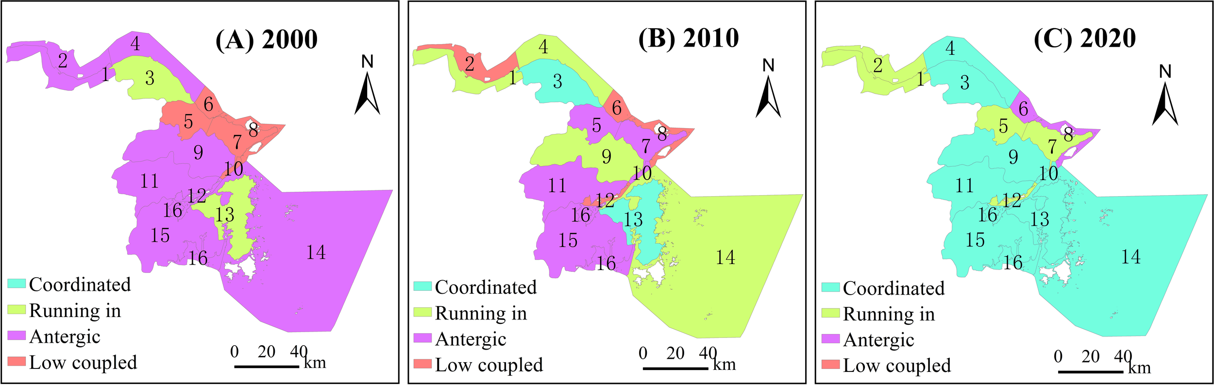
Distribution of the functional coupling degree of the triple space in the coastal zone of Ningbo. The distribution of functional coupling degree levels in (A) 2000, (B) 2010, and (C) 2020.
Using the frequency analysis method (Ge et al., 2017), temporal evolution curves for the functional coupling degree of triple space were generated according to the grading of functional coupling degree, with results indicating an overall increase in the grading. The overall evolution curve was generated based on the curves for functional coupling obtained for 2000, 2010, and 2020 (Figure 4), with results showing fluctuation from 2000 to 2020; however, the triple space gradually self-adjusts, exhibiting a trend towards ordered development.
Figure 4
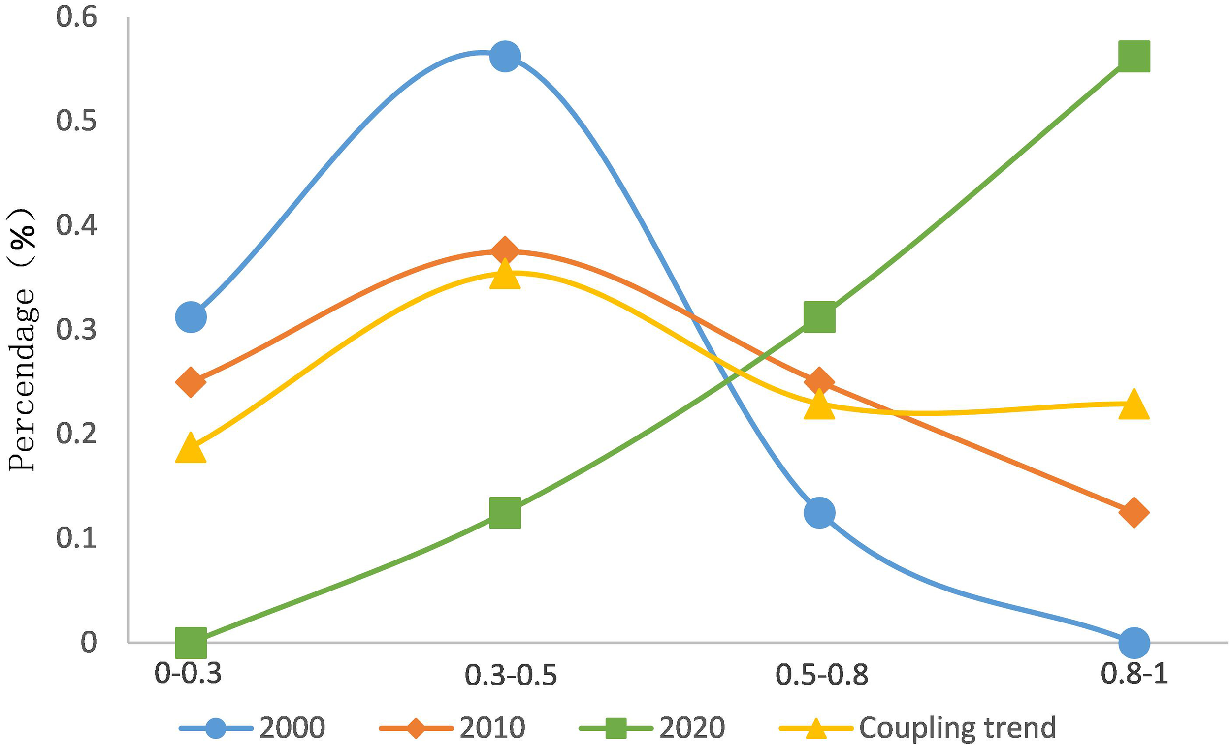
Evolution trend of the functional coupling degree for the triple space in the coastal zone of Ningbo. There were four levels, namely low coupled ([0–0.3)), antergic ([0.3–0.5)), running in ([0.5–0.8)), and coordinated ([0.8–1]).
3.2 Spatiotemporal variation in the coupling coordination degree
The coupling coordination degree for the triple space was obtained using (Equation 8), and spatial distribution maps showing the coupling coordination degree for the years 2000, 2010, and 2020 were generated (Figure 5). Spatially, areas with high coupling coordination are generally consistent with those with high functional coupling, with both manifesting as “high in the south and north and low in the middle.” Temporally, the coupling coordination degree overall transitions from “moderate imbalance” to “moderate coordination,” with the coupling coordination degree in the range of 0.21– 0.64 in 2000 mainly manifesting as moderate imbalance (68.75%), basic coordination (18.75%), and moderate coordination (12.5%). The lowest value was observed in the sea area of Zhenhai District and the highest in the land surrounding Cixi City. The coupling coordination degree was low overall and manifested predominantly as a moderate imbalance. In 2010, the coupling coordination degree was in the range of 0.22–0.62 and mainly manifested as moderate imbalance (50%), basic coordination (31.25%), and moderate coordination (18.75%), with the lowest value observed in the sea areas of Zhenhai District, and the highest in the land surrounding Xiangshan County. The coupling coordination degree was predominantly in the form of moderate imbalance (with a significant decline in the proportion as compared to that in 2000), while a marginal increase was observed in the proportions of basic and moderate coordination. In 2020, the coupling coordination degree of triple space was in the range of 0.24–0.65 and was mainly manifested as moderate imbalance (12.5%), basic coordination (25%), and moderate coordination (62.5%), with the lowest value observed in the sea areas of Beilun District, and the highest in the land surrounding Xiangshan County. The coupling coordination degree was generally manifested as moderate coordination. Since 2010, appropriate measures were taken in Ningbo to optimize the spatial pattern of its land development, promote resource conservation, and strengthen ecosystem and environmental protection. The implementation of related policies (e.g., forewarning of resource and environmental bearing capacities, land planning, and land regulation and error correction for the coastal zone) has effectively restored the ecological function, improved the living environment, and promoted the efficient and intensive use of the resources within the zone, thus increasing the coupling coordination degree from moderate imbalance to moderate coordination.
Figure 5
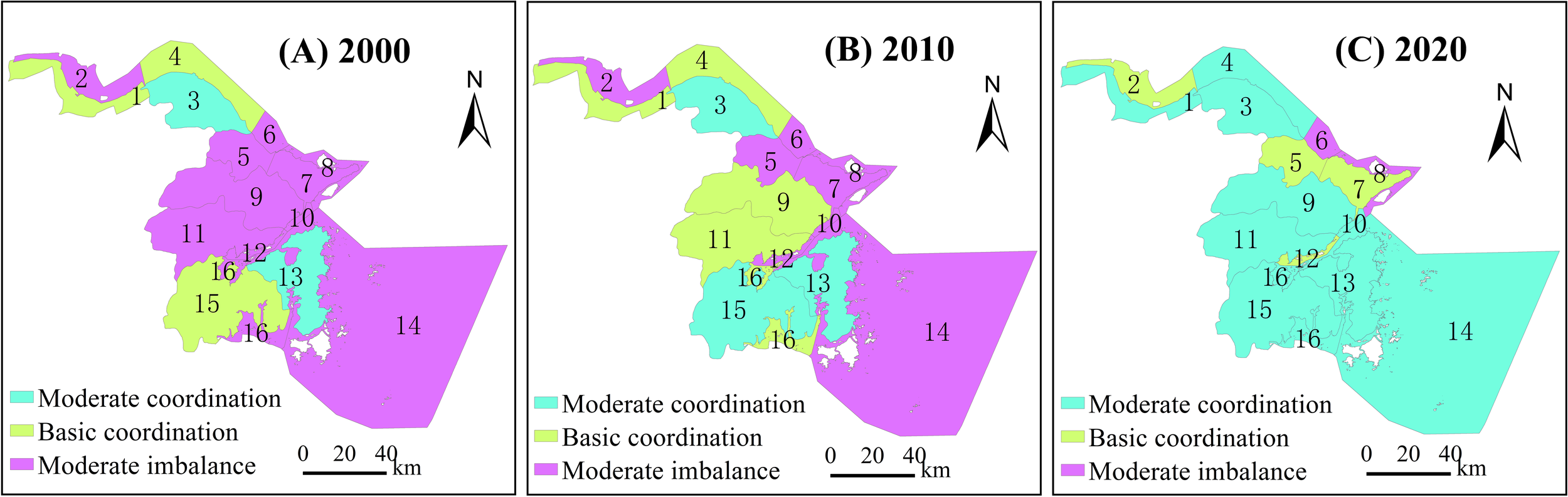
Distribution of the coupling coordination degree of the triple space in the coastal zone of Ningbo. The distribution of coupling coordination degree levels in (A) 2000, (B) 2010, and (C) 2020.
Using the frequency analysis method, temporal evolution curves for the coupling coordination degree of the triple space were also generated according to the grading of the coupling coordination degree. Overall, the coupling coordination degree increases gradually, with the most significant increase at the stage of moderate coordination. An overall evolution curve describing the coupling coordination was then generated based on the curves for the coupling coordination degree in 2000, 2010, and 2020 (Figure 6), with results showing a U-shaped variation pattern from 2000 to 2020, which gradually evolves toward high coordination, suggesting that development of the triple space was undertaken in a more coordinated and ordered manner. Before 2000, economic construction was the main task. Industrial parks, ports, transportation were developing rapidly. Reclamation led to the reduction of coastal mudflat and wetland resources and the degradation of biodiversity. In 2010, efforts were made to strengthen ecological environment construction and protection, including the protection of natural shoreline, implementation of strict reclamation management, evaluation of the resource and environment carrying capacity, and optimization of coastal utilization, transforming the relationship of the three from the bottom from excessive to coordinated in 2010 and 2020, respectively.
Figure 6
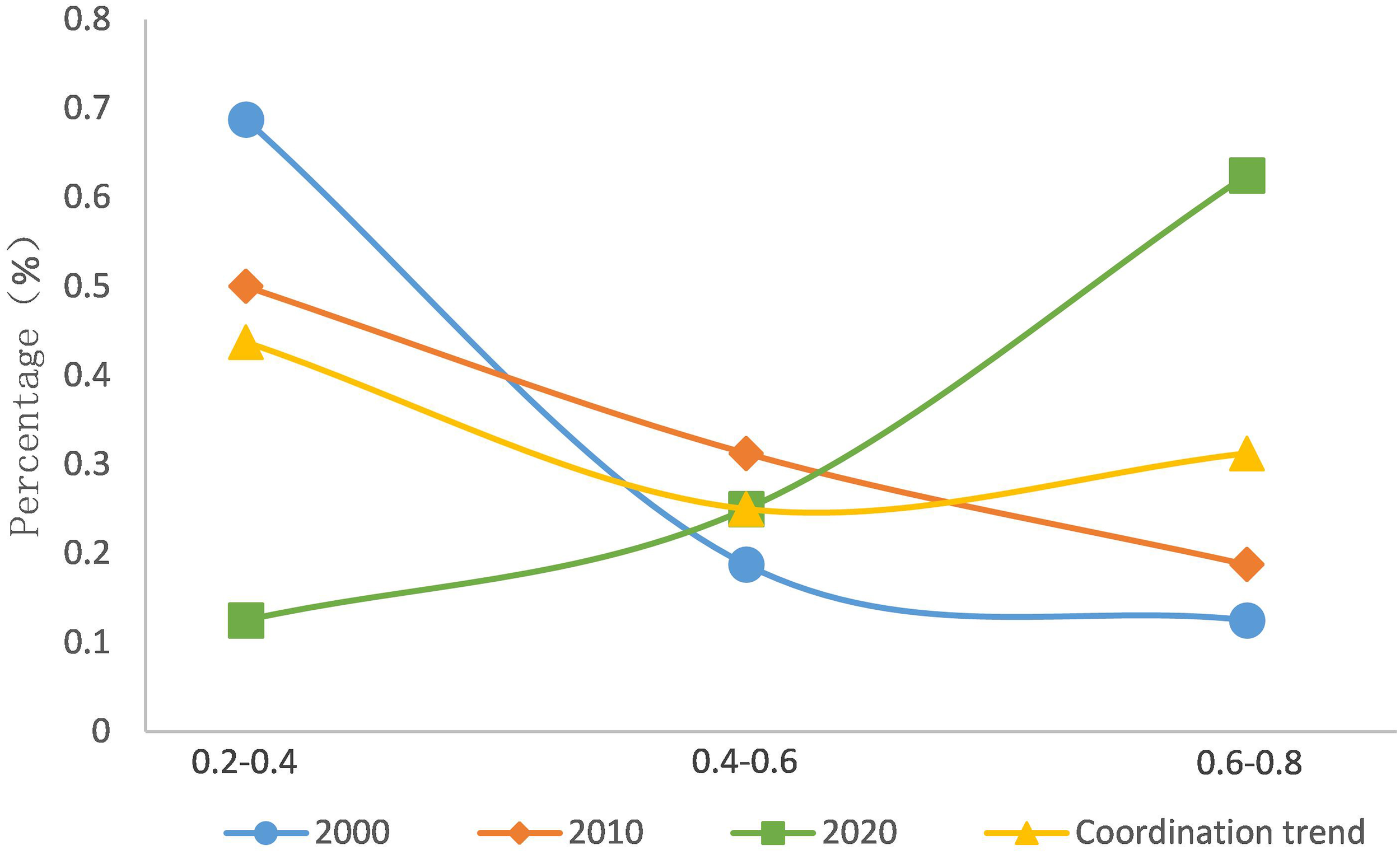
Evolution trend of the coupling coordination degree for the triple space in the coastal zone of Ningbo. There were five levels, namely extreme imbalance ([0–0.2)), moderate imbalance ([0.2–0.4)), basic coordination ([0.4–0.6)), moderate coordination ([0.6–0.8)), and extreme coordination ([0.8–1]).
3.3 Spatiotemporal characteristics of the pairwise functional coupling coordination degree of the triple space
To fully reveal the functional interactions across the triple space in the coastal zone of Ningbo, the pairwise functional coupling and coupling coordination relationships were further analyzed, with the pairwise functional coupling and coupling coordination degrees calculated and spatial distribution generated using (Equations 5–7 and Equations 9–11) (Figures 7, 8). Evolution curves were then generated using the obtained values (Figures 9, 10).
Figure 7
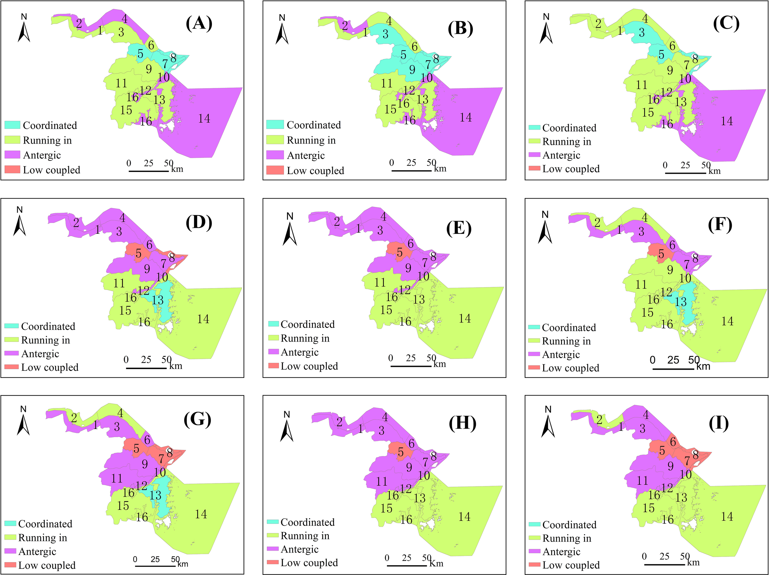
Distribution maps showing the pairwise functional coupling degree in the triple space of the coastal zone of Ningbo in 2000, 2010, and 2020: (A–C) Living-production coupling; (D–F) Ecological-production coupling; and (G–I) Ecological-living coupling.
Figure 8
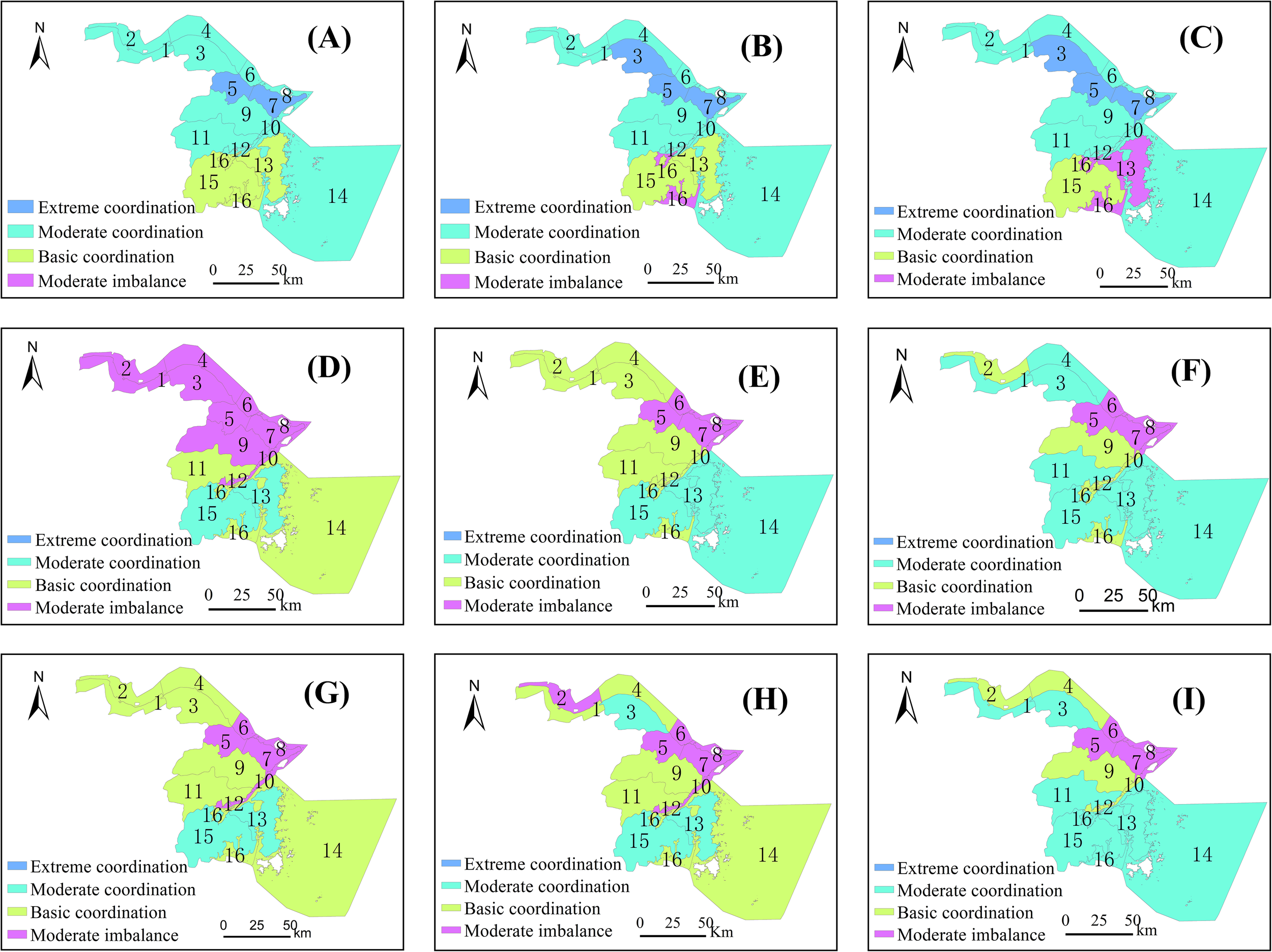
Distribution maps showing pairwise coupling coordination degree for the triple space of the coastal zone of Ningbo in 2000, 2010, and 2020: (A–C) Living-production coupling coordination degree; (D–F) Ecological-production coupling coordination degree; (G–I) Ecological-living coupling coordination.
Figure 9
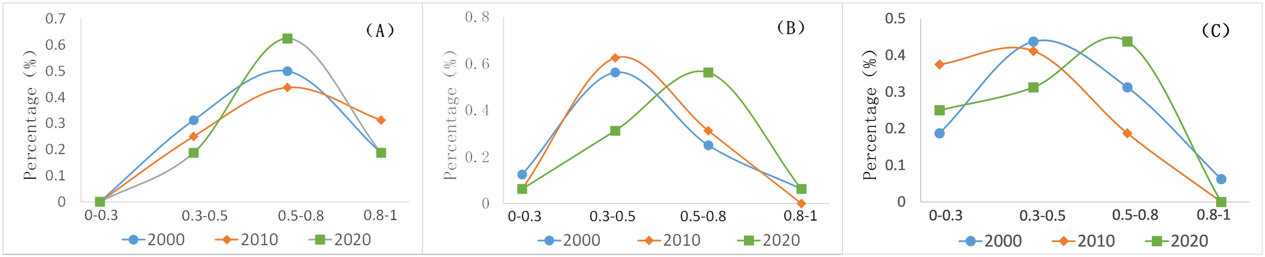
Evolution curves for pairwise functional coupling degree of triple space in the coastal zone of Ningbo: (A) Living-production coupling; (B) Ecological-production coupling; and (C) Ecological-living coupling degrees.
Figure 10
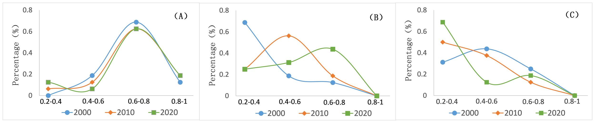
Evolution curves for the pairwise coupling coordination degree of triple space in the coastal zone of Ningbo: (A) Living-production; (B) Ecological-production; (C) Ecological-living coupling coordination degrees.
The living-production coupling and coupling coordination degrees in the coastal zone of Ningbo are significantly higher than those obtained for ecological-production and ecological-living coupling overall, with a continuously increasing trend. This is due to the mutual promotion between production and living over long periods. Specifically, production provides a firm material base for economic development, guaranteeing the maintenance and improvement of the livelihoods of the residents. Improvements to the living functions attract personnel and technologies, further developing the production functions. Temporally, with the integrated development of triple space, production activities and services in the coastal zone become more diverse, ecological functions are further optimized and upgraded, living standards are improved, and various services (e.g., housing, medicine, education, and social security) are further improved. After experiencing long-standing antergia and imbalance, the living and production functions tend to develop at high coupling and coordination levels.
The ecological-production coupling coordination degree continues to increase more rapidly than living-production and ecological-living coupling coordination, changing from extreme imbalance to moderate coordination. The ecological-production coupling coordination in the coastal zone of Ningbo is essentially a process under which coastal production space grabs and contends for resources from the ecological space. In the early days, various coastal industries (e.g., harbor and shipping, coastal industrial parks, offshore fishery, and agricultural reclamation) encroached on the coastal ecological resources, and the discharge of production waste (e.g., oil dirt, chemical wastes, microplastics, pesticides, and fertilizers) caused many ecological problems (e.g., deterioration of seawater quality, soil salinization, and coastal erosion), leading to a fragile coastal ecological space. As coastal economic activities caused increasingly severe ecological problems, ecological restoration and construction have become key solutions to human-sea symbiosis and the harmonious development of coastal zones. China implemented a series of production pollution control projects (e.g., construction of beautiful bays, prohibition of sea reclamation, beach restoration and treatment, and pollution control at sea outfalls), changed the traditional production modes, and encouraged the development of green and ecological industries, thus improving the ecological-production coupling coordination degree.
The ecological-living coupling coordination degree in the coastal zone of Ningbo overall shows a fluctuating trend of “decrease first then increase” (manifested as basic coordination, moderate imbalance, and moderate coordination), and is relatively low. In the competition between ecological and living space, ecological functions are weakened for various reasons (e.g., underdeveloped infrastructure and weak environmental consciousness, emphasis on construction but disregard of governance, and inefficiency of domestic garbage and sewage treatment), resulting in a low ecological-living coupling coordination degree. Spatially, the ecological-living coupling coordination degree is high in the south and north of the zone, diffusing toward the middle of the zone. Temporally, the ecological-living coupling coordination degree is relatively low. Hence, strengthening the optimization and coordination of ecological-living coupling remains necessary.
4 Discussion and conclusions
Using the global and local Moran indices, the overall variation in the coupling coordination degree of the triple space in the coastal zone of Ningbo was obtained, and the similarity and correlation of the coupling coordination degree between adjacent spatial units were ascertained in this study.
The global Moran index can be used to measure overall spatial correlation, identify the spatial pattern of a whole coastal zone, and judge the spatial autocorrelation in the coastal zone. The global Moran index is expressed as follows:
where n denotes the total number of spatial units in a coastal zone, i and j denote the serial numbers of spatial units, denote the attribute values of spatial units, denotes the average value of spatial units in a coastal zone, and denotes the weight of a spatial unit in a coastal zone.
The global Moran index lies within the range with an I of -1 indicating that the areas of the coastal zone are discrete overall with the coupling coordination degree differing between adjacent areas, an I of around 0 indicating random distribution and no obvious correlation between adjacent areas, and an I of 1 indicating clustering, and a similar coupling coordination degree in different areas. In this study, the coupling coordination degree was used as the attribute value, with the 5% significance level at .
As a supplement to the global Moran index, the local Moran index can be used to explore and analyze the correlation between a specific spatial unit and its adjacent units on a more microscopic scale, or specifically, evaluate the similarity and correlation between the attribute eigenvalues of adjacent spatial units in a coastal zone. The local Moran index is expressed as follows:
where denotes the standard deviation, n denotes the total number of spatial units in a coastal zone, denote the serial numbers of spatial units, are attribute values of the spatial units, denotes the average value of the spatial units, denotes the weight of a spatial unit, and denotes the local Moran index of the i-th area. The obtained results can be used to classify areas of a coastal zone into four types (Table 4).
Table 4
| Description | |||
|---|---|---|---|
| High-high cluster area | >0 | >0 | High-value diffusion area with high coupling coordination degree: The study area is well coordinated with adjacent areas. |
| Low-low cluster area | <0 | <0 | Low-value subsidence area with low coupling coordination degree. Areas adjacent to the study area are low-value, and the study area is in transition from high coupling coordination to low coupling coordination. |
| Low-high cluster area | <0 | >0 | High-value polarization area with high coupling coordination degree. The study area can barely drive optimal development in adjacent areas. |
| High-low cluster area | >0 | <0 | Low-value constraint area with low coupling coordination degree. The study area severely constrains the optimal development of both itself and adjacent areas. |
Description of the global Moran index.
The global Moran index of the triple space was calculated for different years using (Equation 12) (Table 5). The triple space failed to pass the significance test in 2000 and 2020, suggesting that the coupling coordination degree of the 16 areas in the coastal zone of Ningbo tends towards random distribution and fluctuation, with no significant discrete or clustering effects and only slight spatial variation observed in the coupling coordination degree. In 2010, the coupling coordination degree of the land–sea space in the coastal zone of Ningbo manifested as the clustering of similar attributes. The above analysis suggests that the coupling coordination degree of the triple space has fluctuated overall, following a trend of “random distribution, clustering, and random distribution,” with no significant discrete or clustering effect. Briefly, the coupling coordination degree for the triple space is not high and is not significantly affected by adjacent areas.
Table 5
| Year | Moran I | Z | P |
|---|---|---|---|
| 2000 | 0.07 | 0.96 | 0.34 |
| 2010 | 0.31 | 2.46 | 0.01 |
| 2020 | 0.13 | 1.3 | 0.19 |
Global Moran index of the coastal zone of Ningbo.
The local Moran index was calculated using (Equation 13) to determine the coupling coordination degree of the 16 areas in the coastal zone of Ningbo (Figure 11). No significant spatial automation was observed across the three years (2000, 2010, and 2020). As shown in Figure 11, the coupling coordination degree differed mainly in 10 areas of the coastal zone, including the land and sea areas of Cixi City; Zhenhai, Beilun, and Yinzhou districts; and Ninghai County. The land and sea areas of Zhenhai and Beilun districts are low-value cluster areas (L-L distribution) in 2000 and 2020, suggesting that their coupling coordination degree has improved, although their ecological and living space has not sufficiently developed, restricting development for both themselves and any adjacent areas. In 2010, the land and sea areas of Cixi City and Ninghai County were high-value cluster areas (H-H diffusion), suggesting good development for these areas, which could keep up with and drive the development of adjacent areas. In 2020, the land and sea areas of Yinzhou District are high-value polarization areas (H-L), i.e., these areas have a high coupling coordination degree and are transforming from low-value constraint to high-value polarization areas; however, they are in a clustered state and cannot effectively drive the development of adjacent areas.
Figure 11
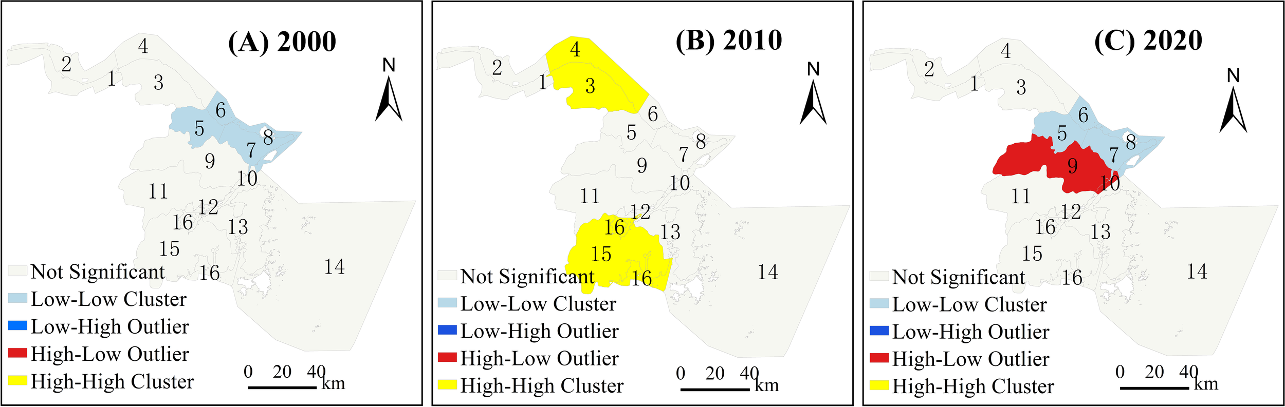
Spatial variation of global Moran index of triple space in Ningbo’s coastal zone. The distribution of global Moran index levels in (A) 2000, (B) 2010, and (C) 2020.
From 2000 to 2020, a cross-coupling relationship was observed in the triple space of the coastal zone in Ningbo, with the functional coupling degree manifested as four types: low coupling, antergia, run-in, and coordination, and the coupling coordination degree as three: moderate imbalance, basic coordination, and moderate coordination. The functional coupling degree of the triple space showed a significant spatiotemporal variation pattern, which is spatially “high in the south and north, and low in the middle,” and the local coupling coordination centers that are distributed in Cixi City and Xiangshan County gradually diffusing towards the middle. Temporally, the functional coupling degree shows a U-shaped variation trend from imbalance to coordination. According to the development characteristics of triple, a differentiated optimization and coordination strategy could be formulated to promote the development of the triple space in a more ordered and coordinated manner.
The pairwise functional coupling coordination degree of the triple space is also significantly different, with ecological-living relatively low among the pairwise functional coupling coordination degree, and the ecological-production coupling coordination degree increasing more rapidly than that by ecological-living and living-production. The living-production coupling coordination degree has increased most significantly and is significantly higher than that of both the ecological-production and ecological-living coupling coordination degrees. In the future, it is necessary to optimize ecological living, strictly control the intrusion of living space into ecological space, and strengthen the treatment of domestic waste and pollution through policy measures and financial input, optimizing the ecological environment and promoting the sustainable development of the ecological and living spaces.
Spatially, the coupling coordination degree of triple space is overall randomly distributed, with no obvious clustering or discrete effects. The land and sea areas of Yinzhou District are evidently high-value polarization areas, and despite a high coupling coordination degree, which is abrupt and did not drive the development of adjacent low value areas. The coupling coordination degree of land and sea areas in Zhenhai and Beilun districts is still low but shows an increasing trend. The land and sea areas in Cixi City and Ninghai County are well developed but show no strong polarization effect. In other areas of the coastal zone in Ningbo, the coupling coordination degree does not vary significantly and tends to fluctuate.
Based on the above conclusions, the following policy recommendations are proposed for the coastal planning of Ningbo City:
Protect the wetland and mudflat in Xiangshan Port and Sanmen Bay, prohibit reclamation of mudflat, control the scale of industrial agglomeration along the coast, prohibit the construction of polluting enterprises, and strictly control the ecological environment pollution in the bay.
Ecological engineering measures allow the construction of public waterfront infrastructure in the living areas of Yuyao and Cixi Cities, ensuring the public openness of the living shoreline. Simultaneously, the region should also strengthen environmental protection and ecological construction.
Beilun and Zhenhai Districts should intensively utilize coastal resources, implement ecological transformation of artificial seawalls, and vigorously develop emerging industries, such as green ports, logistics, new energy, and ecological chemicals.
Explore the innovative mechanism of ecological compensation in the coastal zone of Ningbo, explore to consider natural resources, such as the natural shoreline, mudflat, and wetlands as quantitative entities for converting ecological credits, and establish an ecological account system based on tradable ecological credits.
The functional coupling of the triple space in a coastal zone is a complex interaction process. This study examined the quantitative interaction relationship between the triple space functions in the coastal zone of Ningbo. Our findings are expected to provide a new approach and reference for the triple space theory in sea area planning, give direction for the functional optimization and coordination of the triple space in coastal zones, and provide valuable reference for policy formulation and planning. Owing to the spatial complexity of coastal zones, further studies should pay more attention to refining the spatiotemporal data and optimizing the functional coupling mechanism model describing the triple space in this type of zone.
Statements
Data availability statement
The original contributions presented in the study are included in the article/supplementary material. Further inquiries can be directed to the corresponding author.
Author contributions
BW: Conceptualization, Data curation, Methodology, Writing – original draft, Writing – review & editing, Funding acquisition. AS: Investigation, Validation, Writing – review & editing, Formal Analysis, Funding acquisition. YC: Conceptualization, Methodology, Supervision, Writing – review & editing, Funding acquisition.
Funding
The author(s) declare that financial support was received for the research and/or publication of this article. This work was supported by the National Natural Science Fund of China (grant numbers 42276236) and the Ministry of Natural Resources under a special project for financial support for the implementation of spatial planning under a land–sea coordination strategy (grant number CBNB-20186212G).
Acknowledgments
We would like to thank the editors of Editage (www.editate.cn) for English language editing. Reviewers supplied constructive feedback that helped to improve this paper.
Conflict of interest
The authors declare that the research was conducted in the absence of any commercial or financial relationships that could be construed as a potential conflict of interest.
Generative AI statement
The author(s) declare that no Generative AI was used in the creation of this manuscript.
Publisher’s note
All claims expressed in this article are solely those of the authors and do not necessarily represent those of their affiliated organizations, or those of the publisher, the editors and the reviewers. Any product that may be evaluated in this article, or claim that may be made by its manufacturer, is not guaranteed or endorsed by the publisher.
References
1
Chen J. Shi P. J. (2005). Discussion on functional land use classification system. J. Beijing Norm. Univ. (Nat. Sci.).41, 536–540.
2
Chen Q. Q. Shu X. B. Zeng F. B. (2020). Multi-scale analysis of the spatiotemporal pattern of the spatial structure of ecology-production-living space in Jiangxi Province. Res. Soil Water Conserv.27, 385–391.
3
Cui J. X. Gu J. Sun J. W. Luo J. (2018). The spatial pattern and evolution characteristics of the production, living and ecological space in Hubei Provence. China Land Sci.32, 67–73.
4
Fan J. Li P. (2009). The scientific foundation of major function oriented zoning in China. J. Geogr. Sci.19, 515–531. doi: 10.1007/s11442-009-0515-0
5
Fleischer A. Tchetchik A. (2005). Does rural tourism benefit from agriculture? Tourism Manage.26, 493–501. doi: 10.1016/j.tourman.2003.10.003
6
Ge D. Z. Long H. L. Zhang Y. N. Tu S. S. (2017). Pattern and coupling relationship between grain yield and agricultural labor changes at county level in China. Acta Geol. Sin. (Engl.).72, 1063–1010.
7
Ghaderi Z. Henderson J. C. (2012). Sustainable rural tourism in Iran: A perspective from Hawraman Village. Tourism Manage. Perspect.2–3, 47–54. doi: 10.1016/j.tmp.2012.03.001
8
Gulickx M. M. C. Verburg P. H. Stoorvogel J. J. Kok K. Veldkamp A. (2013). Mapping landscape services: A case study in a multifunctional rural landscape in the Netherlands. Ecol. Indic.24, 273–283. doi: 10.1016/j.ecolind.2012.07.005
9
Hersperger A. M. Oliveira E. Pagliarin S. Palka G. Verburg P. Bolliger J. et al . (2018). Urban land-use change: The role of strategic spatial planning. Glob. Environ. Change.51, 32–42. doi: 10.1016/j.gloenvcha.2018.05.001
10
Hong H. K. Xie D. T. Guo L. B. Hu R. Liao H. P. (2017). Differentiation of spatial function in a mountainous rural area from a multi-functional perspective. Acta Ecol. Sin.37, 2415–2427.
11
Huang J. C. Lin H. X. Qi X. X. (2017). A literature review on optimization of spatial development pattern based on ecological-production-living space. Prog. Geogr.36, 378–391. doi: 10.18306/dlkxjz.2017.03.014
12
Jia L. N. Liang S. Y. (2018). Assessment of geohazards susceptibility for Huachi County by the optimal combined weight method. J. Geol. Hazards Environ. Preserv.29, 61–67.
13
Jin G. Wang Z. Q. Yao X. W. Yang J. (2013). Concept and methods for spatial zoning. China Land Sci.27, 48–53.
14
Jones K. R. Venter O. Fuller R. A. Allan J. R. Maxwell S. L. Negret P. et al . (2018). One-third of global protected land is under intense human pressure. Science360, 788–791. doi: 10.1126/science.aap9565
15
Koomen E. Rietveld P. de Nijs T. (2008). Modelling land-use change for spatial planning support. Ann. Reg. Sci.42, 1–10. doi: 10.1007/s00168-007-0155-1
16
Li B. H. Zeng C. Dou Y. D. Liu P. Chen C. J. P. G. (2018). Change of human settlement environment and driving mechanism in traditional villages based on living-production-ecological space: A case study of Lanxi village, Jiangyong county, Hunan Province. Prog. Geogr.37, 677–687. doi: 10.18306/dlkxjz.2018.05.011
17
Liu J. Y. Kuang W. H. Zhang Z. X. Xu X. L. Qin Y. W. Ning J. et al . (2014). Spatiotemporal characteristics, patterns, and causes of land use changes in China since the late 1980s. J. Geograph. Sci.24, 195–210. doi: 10.1007/s11442-014-1082-6
18
Liu P. F. Sun B. D. (2020). The spatial pattern of urban production-living-ecological space quality and its related factors in China. Geogr. Res.39, 13–24.
19
Lu C. P. Ji W. Liu Z. L. Mao J. H. Li J. Z. Xue B. (2022). Spatial temporal pattern and influencing factors of the “production-living-ecological” functional space of the Yellow River Basin at county level in Gansu China. Sci. Geogr. Sin.42, 579–588.
20
Luo K. S. Li R. D. Chang B. R. (2013). Land-cover survey method using object-oriented technology and HJ-CCD image on large scale. J. Univ. Chin. Acad. Sci.30, 770–778.
21
Meng L. N. Zheng X. Q. Zhao L. Deng J. (2011). Land-use functional regionalization based on niche-fitness model, Trans. CSAE27, 282–287.
22
Nelson E. Mendoza G. Regetz J. Polasky S. Tallis H. Cameron D. et al . (2009). Modeling multiple ecosystem services, biodiversity conservation, commodity production, and tradeoffs at landscape scales. Front. Ecol. Environ.7, 4–11. doi: 10.1890/080023
23
Sun P. L. Xu Y. Q. Liu Q. G. Liu C. Huang A. (2017). Spatiotemporal differentiation and driving factors of multi-functionality of land use in county scale in poverty belt around Beijing and Tianjin. Trans. Chin. Soc Agric. Eng.33, 283–292.
24
Wang F. Dong Y. X. (2015). Dynamic evaluation of land use functions based on grey relation projection method and diagnosis of its obstacle indicators: A case study of Guangzhou city. J. Nat. Resour.30, 1698–1713.
25
Wang C. Y. Wang A. L. Wang J. Y. Wang R. Y. Jiang Z. R. (2014). Coastal zone land use information extraction based on object-oriented classification method. J. Nat. Resour.29, 1589–1597.
26
Wang Y. H. Yuna Y. Wang Y. L. Zhang X. L. Qiao W. F. (2017). Relationship and mechanism of coupling development between population and land urbanization: A case study of Jiangsu Province. Geogr. Res.36, 149–160.
27
Wang Y. J. Zhang S. W. (2003). Strategic spatial planning: Seeking new steps through practice. Urban Plan. Forum143, 7–12 + 95.
28
Wei B. Q. Li Y. Suo A. N. Zhang Z. F. Xu Y. Chen Y. L. (2021). Spatial suitability evaluation of coastal zone, and zoning optimisation in Ningbo, China. Ocean Coast. Manag.204, 105507. doi: 10.1016/j.ocecoaman.2020.105507
29
Wu Y. J. Yang Y. Z. Yang L. Zhang C. You Z. (2016). Land spatial development and suitability for city construction based on ecological living industrial space-take Ningbo city as an example. Resour. Sci.38, 2072–2081.
30
Xia Z. L. Lan A. J. Fan Z. M. Zhu N. (2023). Spatial and temporal distribution characteristics of landscape ecological risks in Karst mountain watersheds from productive-living-ecological perspective. Bull. Soil Water Conserv43, 256–266 + 276.
31
Xiong J. X. Chen D. L. Peng B. F. Deng S. T. Xie X. M. (2014). Spatiotemporal difference of coupling coordinative degree of ecological carrying capacity in the Dongting lake region. Sci. Geogr. Sin.3, 1108–1116.
32
Xu Y. Cao K. Li M. Xu Z. Z. (2016). Coastal ecological risk assessment: its research progress and prospect. Adv. Earth Sci.31, 137–146.
33
Yang D. L. Sun J. W. Liu Y. Luo J. Zhao Y. L. Zhang J. (2022). Analysis on coupling coordination characteristics of production-living-ecological space in rural settlement in karst mountainous areas-taking Qixingguan district as an example. Res. Soil Water Conserv.29, 337–344.
34
Yuan W. Ma R. F. Wang Y. C. Fang R. R. (2019). The coupling evolution of Ningbo as a harbor city in external traffic and urban development. J. Ningbo Univ. (NSEE).32, 114–120.
35
Zhang Z. Gong J. Wang L. H. (2017). Spatiotemporal development and coupling relationship of urban intensive land use and social economics- a case study of 12 cities in Hubei Province. Res. Soil Water Conserv24, 296–310.
36
Zhang Y. Yang Q. Y. Y. Min J. (2016). An analysis of coupling between the bearing capacity of the ecological environment and the quality of new urbanization in Chongqing. Acta Geogr. Sin.71, 817–828.
37
Zhang J. T. Zhai J. T. (2020). Study on the coupling coordination degree of production-living-ecological space in the coastal central cities of China. Mod. Urban Res.7, 1–7. doi: 10.3969/j.issn.1009-6000.2020.07.001
Summary
Keywords
coastal, ecological-living-production space, coupling coordination degree model, pattern evolution, triple space
Citation
Wei B, Suo A and Chen Y (2025) Spatiotemporal evolution characteristics of functional coupling in the triple space of the sea area of Ningbo. Front. Mar. Sci. 12:1528556. doi: 10.3389/fmars.2025.1528556
Received
15 November 2024
Accepted
21 May 2025
Published
04 June 2025
Volume
12 - 2025
Edited by
Guanqiong Ye, Zhejiang University, China
Reviewed by
Qicheng Meng, Ministry of Natural Resources, China
Lisu Chen, Shanghai Maritime University, China
Qutu Jiang, The University of Hong Kong, Hong Kong SAR, China
Updates
Copyright
© 2025 Wei, Suo and Chen.
This is an open-access article distributed under the terms of the Creative Commons Attribution License (CC BY). The use, distribution or reproduction in other forums is permitted, provided the original author(s) and the copyright owner(s) are credited and that the original publication in this journal is cited, in accordance with accepted academic practice. No use, distribution or reproduction is permitted which does not comply with these terms.
*Correspondence: Yanlong Chen, ylchen_dl@163.com
Disclaimer
All claims expressed in this article are solely those of the authors and do not necessarily represent those of their affiliated organizations, or those of the publisher, the editors and the reviewers. Any product that may be evaluated in this article or claim that may be made by its manufacturer is not guaranteed or endorsed by the publisher.