 Xia Guang
 Ping Yin2*
 Xiangtong Huang
 Bin Chen
 Jinqing Liu
- 1State Key Laboratory of Marine Geology, Tongji University, Shanghai, China
- 2Qingdao Institute of Marine Geology, China Geological Survey, Qingdao, China
- 3College of Earth Science and Engineering, Shandong University of Science and Technology, Qingdao, China
Our study was designed to unravel the provenance signals of sediments from various sediment source-to-sink processes. To achieve this, we systematically collected samples from river basins, estuaries, and offshore waters of the Oujiang River estuary. Analyses of clay minerals and trace geochemical elements (Cr, Th, Sc) were then conducted. Our findings revealed a dynamic pattern of sediment distribution, with the predominant clay minerals in the surface sediment of the offshore area being illite, followed by kaolinite and chlorite, with a minor smectite content. Notably, we observed a gradual increase in the proportions of illite and smectite from the upstream to the estuary, while kaolinite decreased accordingly. The ratios of Cr/Th and Sc/Th in the small mountain rivers also showed a gradual increase, indicating a rising influence of fine-grained sediment from the Yangtze River. Furthermore, we utilized a robust nonlinear mathematical model to determine and quantify the sources and provenance contributions of the clay fraction sediment in the Oujiang River estuary. Our model results revealed that the majority (64%) of the clay fraction sediment in the offshore region of the estuary originates from the Yangtze River. In contrast, sediments from small mountain rivers, including the Oujiang River, contribute an average of 29%, but this can increase to 40% within the Oujiang River estuary and its southern areas. Coastal currents and tides influence the sediment distribution in coastal areas. The Zhe-Min Coastal Current plays a significant role in transporting sediments from the Yangtze River to the estuaries of Zhejiang Province, where they settle in the downstream areas of the current. Moreover, sediment from the Oujiang River is carried southward by the coastal current, most of which is deposited in the estuary and the nearby coastal waters to the south. In conclusion, our study underscores the significant influence of sediments from the Yangtze River on the surface sediments in small mountain rivers and offshore regions near the Zhejiang coastline.
1 Introduction
Global rivers connect land and sea, releasing large amounts of freshwater, sediment, and dissolved substances into the ocean annually. They also play a crucial role in the source-to-sink system along the continental margin (Milliman and Farnsworth, 2011). Estuaries and coastal areas are significant repositories for terrestrial sediment delivered by rivers (Nittrouer et al., 2007). Moreover, the processes from the source to the sink at continental margins play a crucial role in the generation, transportation, and deposition of sediment and contribute to the transmission and alteration of signals originating from the source regions (Walsh et al., 2016).
Two types of sources-to-sink systems have been classified along the continental margins of East Asia (Yang et al., 2016). These are represented by large river systems such as the Yellow, Yangtze, and Pearl rivers, as well as small mountain rivers in Taiwan. Many previous studies have predominantly concentrated on sediment source-to-sink processes in large river systems. However, smaller mountain rivers have received less attention (Jian et al., 2020a, b; Li et al., 2023). Small mountain rivers are more sensitive to rapid natural or anthropogenic episodes than large ones due to relatively high reliefs and small watersheds (Jian et al., 2020b). In addition, small mountain rivers can have high organic carbon burial efficiency, contributing an important source of organic carbon to the ocean sediment (Blair and Aller, 2012; Leithold et al., 2016). Therefore, small mountain rivers have important implications for studying sediment source-to-sink processes and the carbon cycle. Previous work on sediment deposition in the East China Sea indicates that the composition of sediments in small mountain river estuaries and offshore areas in southeastern China is greatly affected by large rivers such as the Yangtze River and the Yellow River, as well as oceanographic factors such as tides and currents (Bi et al., 2017, 2015; Guan et al., 2005). These small mountain river estuaries display more complex sediment source-to-sink processes than those in Taiwan. Therefore, this topic is worthy of further investigation.
As a mountainous tidal river estuary, the Oujiang River estuary experiences strong sediment transport driven by the coupled effects of tides and floods (Liu et al., 2022; Xu and You, 2017). Model simulations suggested that the current directions are roughly in the northwest-southeast direction of the Oujiang River estuary (Bao et al., 2015). The fluvial waters and seawaters are well-mixed in the estuary during spring tide (Xing et al., 2013). Several studies suggest that the fine-grained sediments derived from the Yangtze River in the Oujiang River estuary and their tidal reach (Li et al., 2017; Xu et al., 2011b; Yang, 1995), while Oujiang-sourced materials contribute to the muddy deposit in the inner shelf of the East China Sea (Cong et al., 2022; Zhao et al., 2018). However, the quantitative research on sediment provenance mainly focuses on the Zhe-Min mud belt, and the results are not consistent (Cong et al., 2022; Xu et al., 2016; Xiao et al., 2005; Xue et al., 2018). Therefore, under tidal dynamics, the extent of local rivers’ impacts on surface sediments in the Oujiang River estuary and the contributions of the Yangtze River to this area remain poorly constrained.
Clay minerals form through physical and chemical weathering of parent rock, resulting in a fine grain size. These minerals may be transported to the sea via rivers and resuspended by sea currents. They are excellent indicators of sediment provenance and transport routes (Zöllmer and Irion, 1993; Li and Zhang, 2020). The characteristics of clay minerals, such as their composition, variability in content, and crystalline structure, provide valuable evidence for tracing the origin of marine sediments and reconstructing past environments (Liu et al., 2016, 2010; Xu F. et al., 2009; Yang, 1988). Immobile geochemical elements such as chromium (Cr), scandium (Sc), and thorium (Th) are minimally affected by weathering, sedimentary sorting, diagenesis, and metamorphism. Consequently, these elements can potentially reflect the average composition of the source rocks (Bi et al., 2017; Wei et al., 2004; Yang et al., 2003). Moreover, Cr/Th and Sc/Th ratios are good indicators for tracing magmatic differentiation because Cr and Sc are more compatible than Th during the magmatic differentiation process (Ghosh and Sarkar, 2010; McLennan et al., 1983; Singh, 2009), and because Th is more likely to be enriched in the residuals (Bi et al., 2017). In addition, elements such as Th, Sc, and Cr have very low concentrations in seawater and river water and are primarily transported and preserved in sediments (Taylor and McLennan, 1995). Therefore, the ratios of Cr/Th and Sc/Th are widely employed as effective tracers for source discrimination. The Cr/Th ratio has been used by Condie and Wronkiewicz (1990) as a provenance indicator, based on the fact that it correlates with the Sc/Th ratios. Vital and Stattegger (2000) analyzed the provenance of river-bottom sediments in the lowermost Amazon River using these tracers. Meanwhile, the ratios of Cr/Th and Sc/Th have been successfully utilized in several studies to differentiate between sediment sources of small mountain rivers in Zhejiang Province and the Yangtze River (Bi et al., 2017; Li et al., 2021).
This paper aims to examine the offshore area of the Oujiang River estuary, which is situated in the central part of the Yangtze River sediment impact zone. The objective is to analyze signals from different sediment sources and identify the spatial distribution and controlling factors of these sources by studying clay minerals and sedimentary geochemistry. This study aims to refine and advance our understanding of land-sea interaction mechanisms. Such issues are important for the comprehensive understanding of land-sea interaction and the sediment source-to-sink processes in the macrotidal estuaries.
2 Regional setting and methods
2.1 Regional setting
The offshore area of the Oujiang River estuary is situated on the southeast coast of Zhejiang Province. It comprises Wenzhou Bay and Yueqing Bay in the north and is adjacent to the Zhe-Min mud belt in the east (Figure 1A). The Oujiang River estuary offshore area is characterized by a subtropical monsoon climate, which is warm and humid with abundant rainfall in summer. The surface sediment of the offshore area is primarily composed of fine-grained sediment, with coarser grain sizes present in certain estuaries and tidal channels. Late Jurassic volcanic rocks, consisting mainly of acidic and moderately acidic lava and volcaniclastic rocks, are widely distributed throughout the surrounding continent and islands. Quaternary sediments are also widespread in the coastal plain. In addition, the study area is characterized by semi-diurnal tides with an average tidal range of 4 m, classifying it as a region with intense tidal activity. The offshore region is affected by the Zhe-Min coastal currents. During winter, it flows from north to south due to the East Asian monsoon. This flow is generally limited to waters shallower than 20 m (Bao et al., 2005).
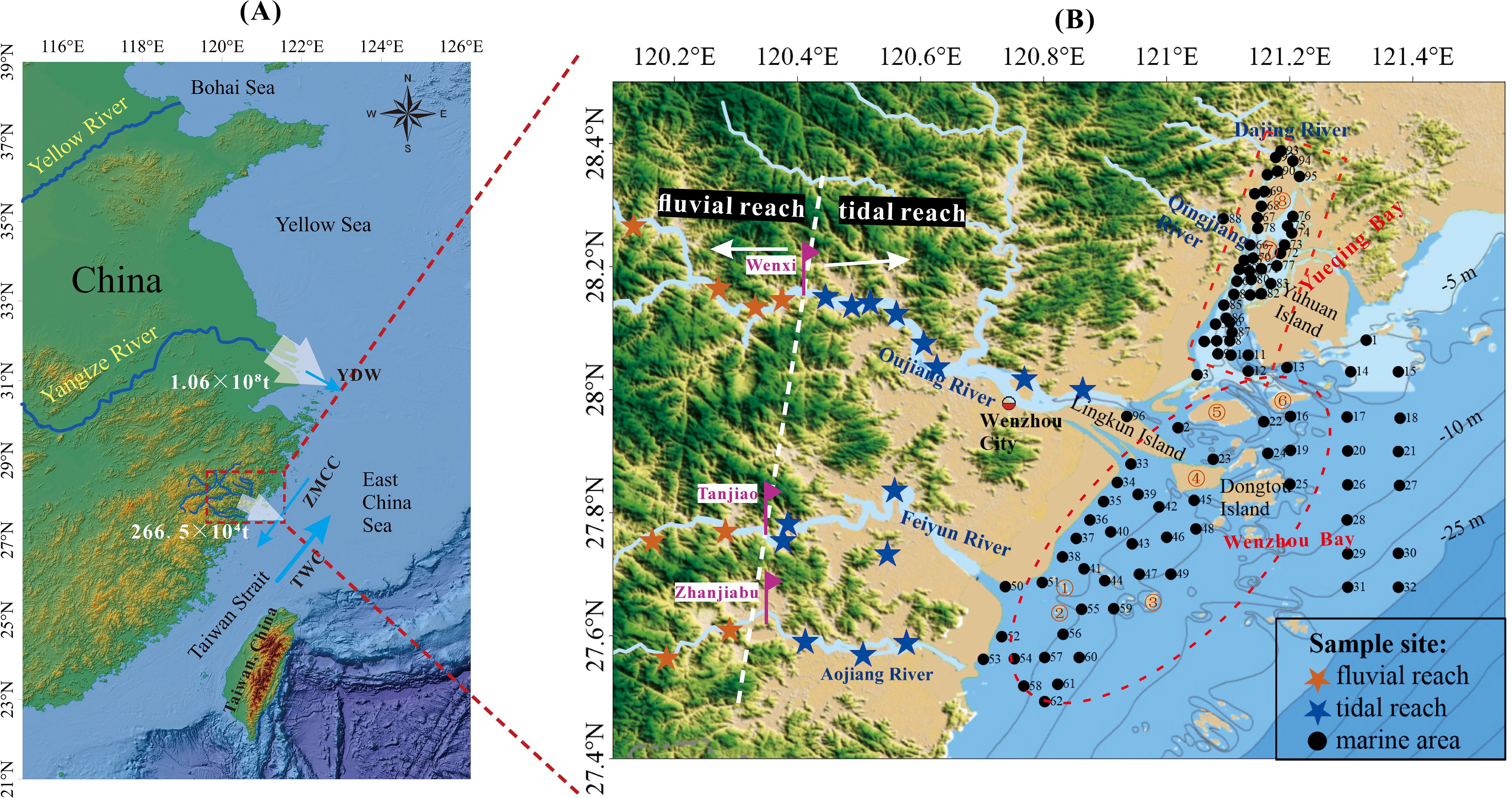
Figure 1. The map depicts the study area, encompassing southeast China and the East China Sea (A). YDW, Yangtze River Diluted Water; ZMCC, Zhe-Min Coastal Current; TWC, Taiwan Warm Current. The White number represents the annual sediment load of the Yangtze River and the Oujiang River. The sample locations in major mountainous rivers and estuaries in Zhejiang Province are shown in (B). Rose-red symbols represent the boundary to distinguish between the fluvial reach and the tidal reach. Place names: ①-Fenghuang Mountain; ②-Chitou Mountain; ③-Beilong Mountain; ④-Niyu Island; ⑤-Damen Island; ⑥-Lusi Island; ⑦-Maoyan Island; ⑧-Ximen Island.
Wenzhou Bay covers a vast sea area, with a total of 1473.69 km2. It is fed by the Oujiang River, Feiyun River, and Aojiang River, originating from the mountainous region of south Zhejiang Province and flowing eastward into the bay. The total watershed area is approximately 2.3×10⁴ km2, with the Oujiang River watershed area accounting for 1.8×10⁴ km2. The Oujiang River spans 388 km, with a tidal section of 79 km and a tidal boundary that extends to Wenxi. The multi-year average runoff and sand transfer volumes are 196×108 m3 and 266.5×10⁴ t, respectively. Several islands are in the bay, and tidal channels have formed between them. The continental coastline of Wenzhou Bay is straight, with obvious siltation. The mudflats, such as Oufei Shoal and Wenzhou Shoal, are well-developed (The Editorial Committee of the Annals of Bays in China, 1993).
Yueqing Bay is a semi-enclosed bay, surrounded by land on three sides, and its opening is oriented towards the southwest, covering a total area of 463.6 km2. The drainage basin of Yueqing Bay spans approximately 1,470 km2 and is fed by around 30 rivers, including the Dajing River, Baixi, and Qingjiang River. The bay exhibits an average annual runoff of approximately 10.3×10⁴ m3. The bay contains numerous islands and has a complex topography with interconnected watercourses. These watercourses typically range from tidal flats in the west to deeper troughs in the eastern reaches of the bay (The Editorial Committee of the Annals of Bays in China, 1993).
2.2 Materials and methods
2.2.1 Samples
In June and July 2017, 121 surface sediment samples were collected in the Oujiang River estuary seas and nearby rivers by the Qingdao Institute of Marine Geology (QIMG). They included 98 samples from the sea area and 23 from the rivers, obtained through survey vessels and land fieldwork, among which 12 river samples were collected from the mainstream of Oujiang River (4 from its upstream and 8 from its tidal reach), 6 from the mainstream of Feiyun River (2 from its upstream and 4 from its tidal reach), and 5 from the mainstream of Aojiang River (2 from its upstream, and 3 from its tidal reach). The sampling locations are shown in Figure 1B. Samples were collected from the uppermost 0–5 cm of the sediment layer to ensure the acquisition of freshly deposited sediments. All samples underwent clay mineral analyses. Additionally, geochemical analyses were performed on samples from estuarine and offshore regions. All of the samples’ pretreatment and measurements were carried out at the Marine Geology Experiment and Testing Centre, Ministry of Natural Resources.
2.2.2 Clay mineral and geochemical analysis
Clay minerals were analyzed using the X-ray diffraction analysis (XRD) technique. Initially, 30 mL of 15% H2O2 was added to the samples and heated in a thermostatic water bath for 1 hour to eliminate organic matter. Then, 30 mL of 20% acetic acid was added to remove the carbonate material and washed 3 times with deionized water. The particles less than 2 µm of each sample were separated by using a conventional Stokes’ law and concentrated by centrifuging. Each sample was transferred to two slides by wet smearing and then air-dried before analysis. The slices containing clay minerals were saturated with ethylene glycol in an oven at 60°C for 12 hours and then placed on the machine for measurement. The German-made D/Max-2500 X-ray diffractometer was used for testing (CuK α radiation, tube voltage 40 kV, tube current 150 mA). It has a scanning angle of 3°-30° (2θ) and a step size of 0.02°. To distinguish between the mixed peaks of chlorite (3.54 Å) and kaolinite (3.58 Å), the samples were repeatedly scanned in 0.01° steps within a scan angle of 24° to 26° (2θ).
Based on Jade 9.0 software and the method proposed by Biscaye (1965), qualitative analysis and semi-quantitative calculations of clay minerals were conducted. From the X-ray diffraction (XRD) patterns of ethylene glycol saturated specimens, characteristic diffraction peak areas were obtained for smectite (17 Å), illite (10 Å), and a combination of kaolinite and chlorite (7 Å), each multiplied by their respective intensity factors of 1, 4, and 2. Subsequently, the chlorite and kaolinite content ratios were determined based on the ratio of their diffraction peak areas, measured at 3.54 Å and 3.58 Å, respectively. The total content of the four clay minerals—smectite, illite, kaolinite, and chlorite—weighted accordingly sums up to 100%. The average error from repetitive samples was found to be less than 5%.
The sample processing procedure for geochemical element testing follows the specific regulations outlined in the “Chemical Analysis Methods for Marine Sediments” (GB/T20260-2006), strictly adhering to its guidelines and protocols. A 0.05g sample was dried at a constant temperature below 60°C and ground to a particle size of less than 250 mesh. Then, the sample is decomposed by adding 10 mL of hydrofluoric acid and 5 mL of nitric acid. The mixture is then heated at a low temperature for 30 minutes. An additional 2 mL of perchloric acid is introduced following a cooling period to facilitate further sample decomposition. Next, the sample is dissolved by incorporating 10 mL of hydrochloric acid to create a solution. Cr, Sc, and Th concentrations were measured using an inductively coupled plasma mass spectrometer (ICP-MS), model 7500a, manufactured by Agilent, USA. Measurement accuracy was verified using GBW07343, GBW07314, GBW07344, and GBW07334, achieving ±5% reproducibility for trace elements.
2.2.3 Quantification of source contributions
Quantitative methods for distinguishing sediment sources include discriminant analysis and mixture models (Lin, 1989; Fan et al., 2002; Pei, 1991). Among these, the method proposed by Fan et al (Fan et al., 2002), based on the principle of “mass conservation”, utilizes a nonlinear mathematical model to quantitatively identify sediment sources. This approach has been widely applied in calculating the material contribution rates of sea areas (Song et al., 2018; Sun et al., 2022; Liu, 2019; Xu et al., 2011a; Xiao et al., 2009). As a result, our study employs this model to quantitatively ascertain the provenance contribution rates of the surface sediments in the offshore area of the Oujiang River estuary. Considering that the potential sources of the surface sediments in this offshore area are the Yangtze River and nearby small mountain rivers, and these small mountain rivers have consistent geological settings and clay mineralogical compositions, only two primary sources, a1 and a2, were taken into account for this research. In this scenario, the nonlinear mathematical model can be expressed as follows.
where the a1 and a2 represent the contributions from the provenance. yi denotes the proportion of the clay mineral index i within marine sediments. The error term ϵi encompasses the influences of other unknown sources and analytical errors, which are collectively treated as random errors in this context.
Objective function: select the minimum value for
Constraint conditions:
After determining the contributions of each source, to assess the calculation accuracy of these contributions, Equation 1 can be expressed in matrix form as follows:
Matrices A and X represent the contributions and clay mineral indices, respectively, in Equation 1.
The variance of Y can be expressed as:
The covariance matrix estimate for the contributions of each source is expressed as:
The square roots of the diagonal elements correspond to the estimated standard deviations of a1, a2,…, an, denoted as σa1, σa2,…, σan.
3 Results
3.1 The content and distribution characteristics of clay minerals
In Figure 2, the surface sediments of the offshore area outside the Oujiang River Estuary primarily contain illite as the dominant clay mineral, with an average content of 60%. Following illite, chlorite is the next prevalent mineral, with an average content of 20%. Kaolinite has an average content of 17%, and smectite has the lowest average content at 4%. The order of the concentrations of the clay mineral assemblage, from highest to lowest, is illite, chlorite, kaolinite, and smectite. The sediment on the surface of the tidal reach of the Oujiang River has similar compositions of clay minerals to those found in the offshore area. The prevalent order of clay minerals is illite, chlorite, kaolinite, and smectite. The average illite content in the sediments is 59%, with chlorite and kaolinite averaging 19%. The average content of smectite shows the lowest value, accounting for 4%. In contrast, the fluvial reach of the Oujiang River has significantly elevated kaolinite, with an average content of 30%, substantially exceeding the chlorite content, which averages at 18%. Moreover, the concentrations of illite and smectite are notably decreased, with smectite being particularly scarce, averaging only 0.3% and being undetectable in certain samples.
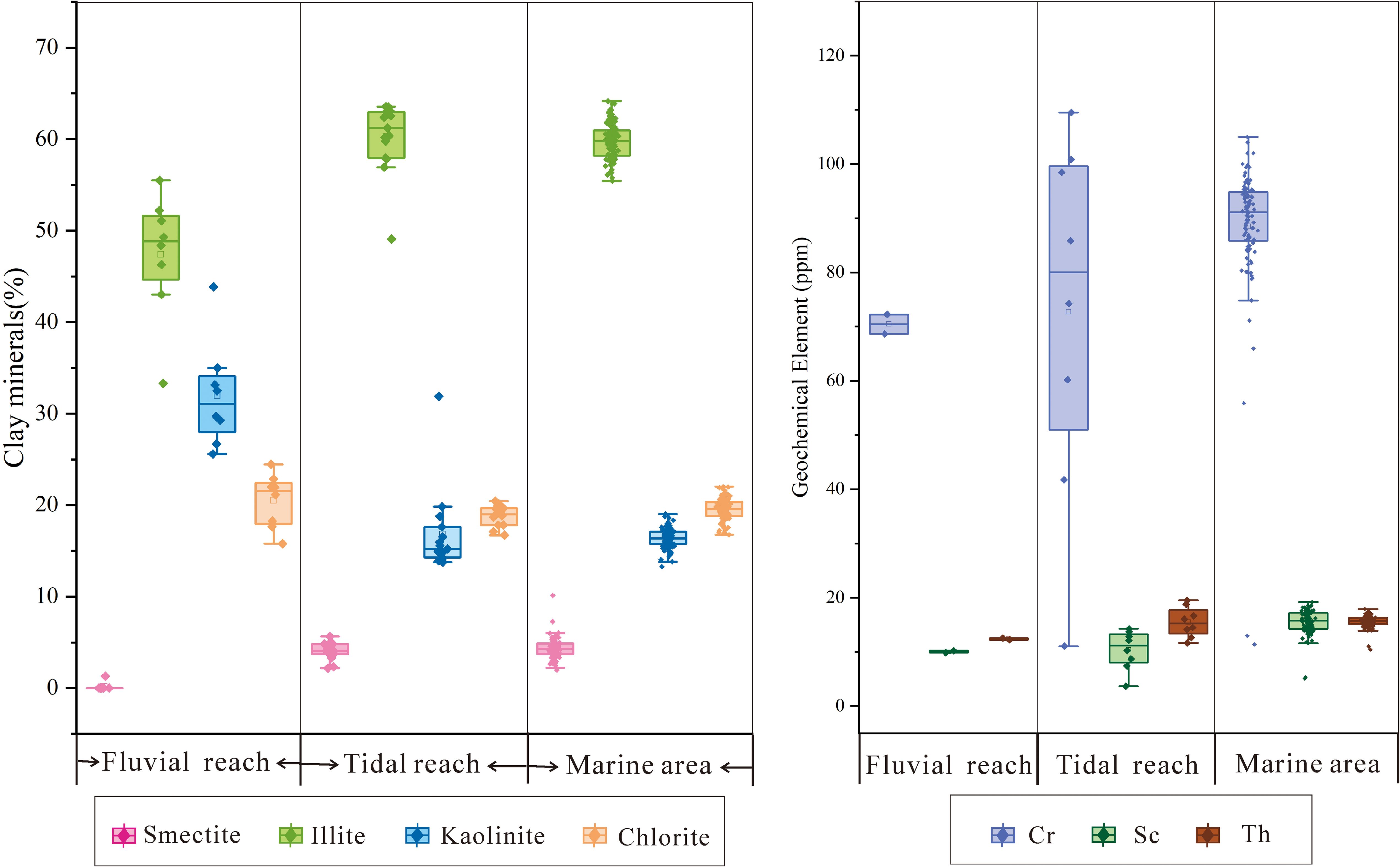
Figure 2. The relative contents of clay minerals (%) and the concentrations of geochemical elements (ppm) in the surface sediments of the study area. Some elemental data for Cr, Th, and Sc in the Oujiang River sediments are referred to the literature (Bi et al., 2017).
In the surface sediments of the offshore area near the Oujiang River estuary, Figure 3 shows that illite is the predominant clay mineral, with its content ranging from 56% to 64%. High concentrations of illite are mainly located to the east of Dongtou, in the central part of Yueqing Bay, and extend from the southern part of Ximen Island to the northern part of Maoyan Island within the bay. Elevated illite concentrations are also observed near Beilong Mountain and Fenghuang Mountain to the south of the Oujiang River estuary. Areas with low illite content are mainly distributed from the Oujiang River estuary to the vicinity of Dongtou Island and at the entrance of Yueqing Bay. The chlorite content ranges from 17% to 22%. Higher values are found in the northwestern part of Damen Island, the southern part of Fenghuang Mountain, Dongtou, and the western side of Yuhuan Island. Lower chlorite contents are located in the northern and eastern parts of Lusi Island, the northern part of Maoyan Island, and near Puqi Port. The kaolinite content varies between 14% and 19%, with higher concentrations predominantly occurring from the southern entrance of the Oujiang River to Damen Island, in the vicinity of Lusi Island, and at the top of Yueqing Bay and Qingjiang Estuary. Elevated kaolinite contents are also observed in the southern part of Dongtou and the southern part of Chitou Mountain. Low levels of kaolinite are mostly found in the central part of the bay, the eastern part of Dongtou, and near Fenghuang Mountain. The distribution pattern of kaolinite generally shows an inverse relationship to that of illite. The content of smectite varies from 2% to 7%, with the highest concentrations mainly observed around Maoyan Island, the southeastern sector of Yuhuan Island, and the outer sea regions. Conversely, lower concentrations of smectite are mainly distributed in a scattered pattern near the coastline, with the content gradually increasing from the shore towards the open sea.
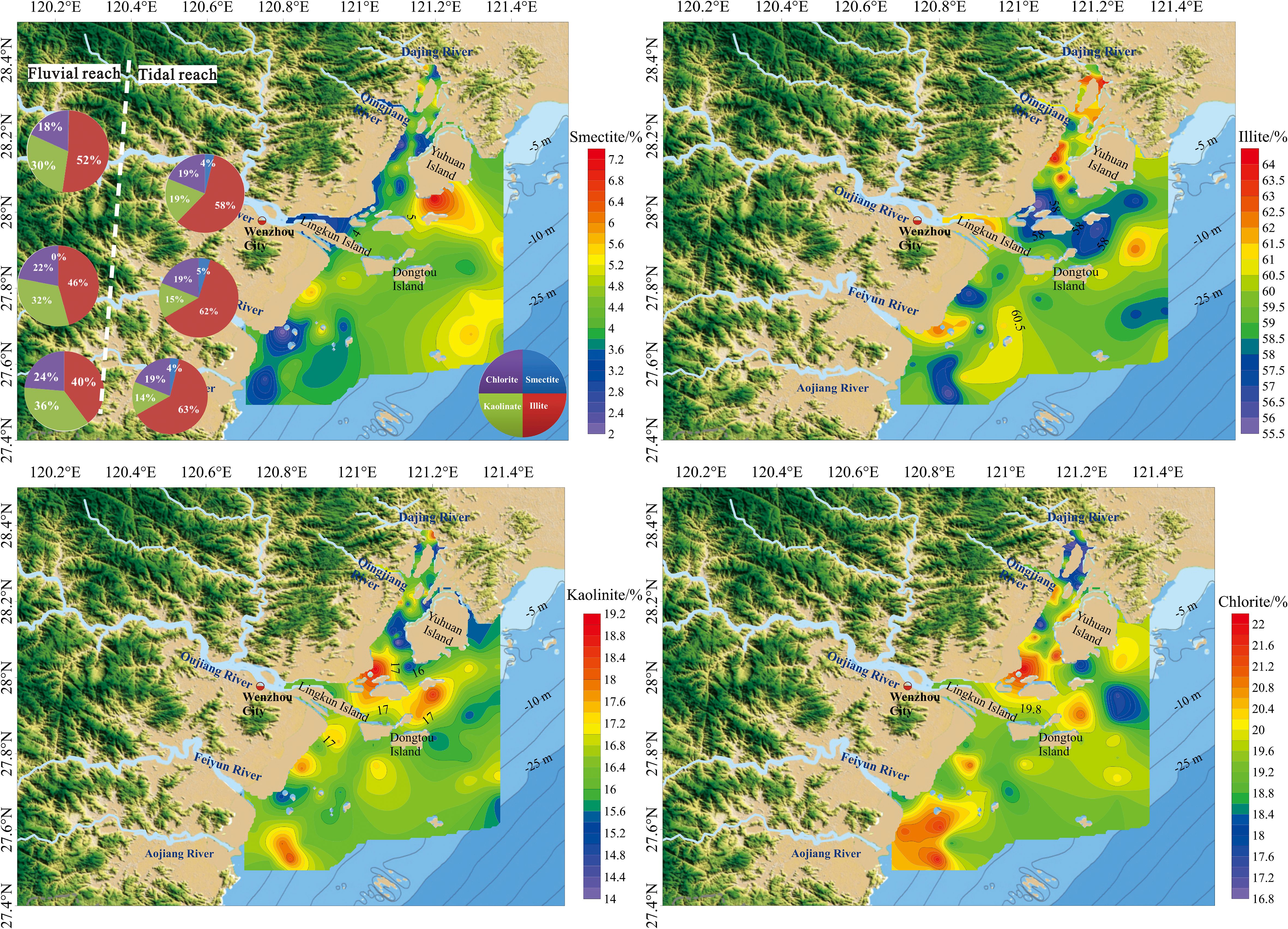
Figure 3. Clay mineral distribution of surface sediments on the Oujiang River estuary. The Pie charts delineate the differential clay mineral assemblages between tidal and fluvial reaches in the small river systems.
3.2 Geochemical element concentrations and distribution characteristics
The average concentrations of trace elements Cr, Sc, and Th in the surface sediments of the Oujiang River estuary are 88.48, 15.50, and 15.63 μg/g, respectively (see Figure 2). As shown in Figure 4, the concentration of Cr ranges from 11.37 to 105.00. The highest values are found in Yueqing Bay and the southern region of the Oujiang River Estuary, while lower concentrations are mainly observed from the Oujiang River’s entrance to the Dongtou Archipelago’s vicinity. The concentration of Sc fluctuates between 5.10 and 19.20, sharing a similar distribution pattern with Cr. Lower levels are seen in the vicinity of the Dongtou Archipelago, with higher concentrations in Yueqing Bay and the southern part of the Oujiang River Estuary. Th concentrations range from 10.42 to 17.90 and show a distributional trend different from Cr and Sc. Notably, Th concentrations are higher near the entrance of the Oujiang River estuary, displaying an overall trend of gradual decrease from the coastline towards the open sea.
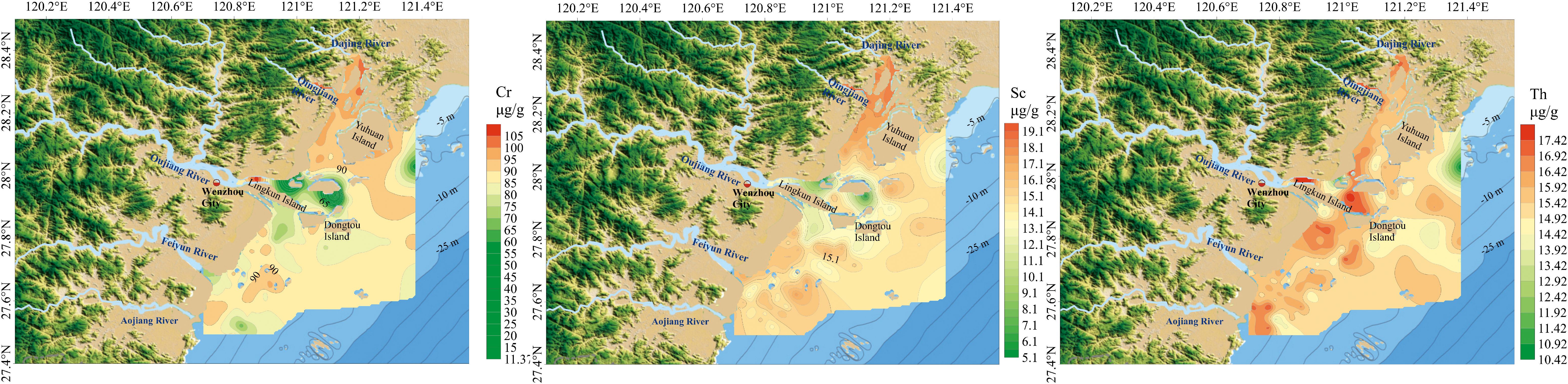
Figure 4. The contents of Cr, Sc, Th in the surface sediments of the Oujiang River estuary.
4 Discussion
4.1 The provenance and spatial distribution of surface sediments in the Oujiang River Estuary
4.1.1 Provenance indications of clay minerals
To investigate the provenance of clay minerals, we compiled data on clay minerals found in the surface sediments of the Yangtze River (Table 1) and Taiwan rivers. We compared it with the data from the current study. In Figure 5, the analysis of clay minerals shows that the sediments in the upper reaches of the Oujiang River have the highest illite content, followed by kaolinite and chlorite, with minimal smectite. On the other hand, the sediments in the tidal reach show an increased content of illite and smectite, and a decrease in kaolinite compared to the upstream sediments. The clay mineral assemblage in the Oujiang River estuary exhibits increasing illite dominance coupled with marked kaolinite depletion, forming a clay assemblage with illite predominance. The clay mineral assemblages of Taiwan rivers are markedly enriched in illite and chlorite, with subordinate kaolinite and smectite, forming a distinct compositional contrast to Oujiang Estuary sediments (Figure 5E). Xu K. et al. (2009) systematically characterized the spatial distribution of clay mineral assemblages in surface sediments across the Taiwan Strait, indicating that clay minerals in the central-northern Taiwan Strait are primarily derived from Yangtze River inputs during winter-spring. Xu et al. (2013) demonstrated that Taiwan-derived fluvial sediments are primarily deposited in the Taiwan Strait’s eastern sector seaward of the 50 m isobath during the summer. Briefly, the study area falls beyond the depositional zone of Taiwan’s riverine outputs. The clay mineral content in the offshore area of the Oujiang River Estuary is a mix of the sediments from the upper reaches and the Yangtze River sediment. This suggests that the surface sediments in the offshore area of the Oujiang River Estuary primarily come from the Yangtze River and the Oujiang River. However, the contents of clay minerals in the sediments of each river vary between the tidal and fluvial reaches, and the clay mineral contents in marine sediments also differ across various regions.
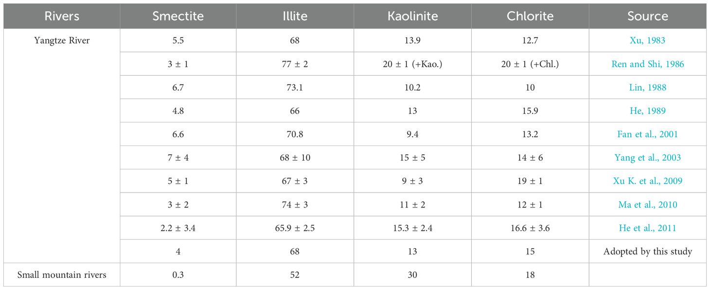
Table 1. The clay mineral content of the Yangtze River and the small mountain rivers along the coast (%).
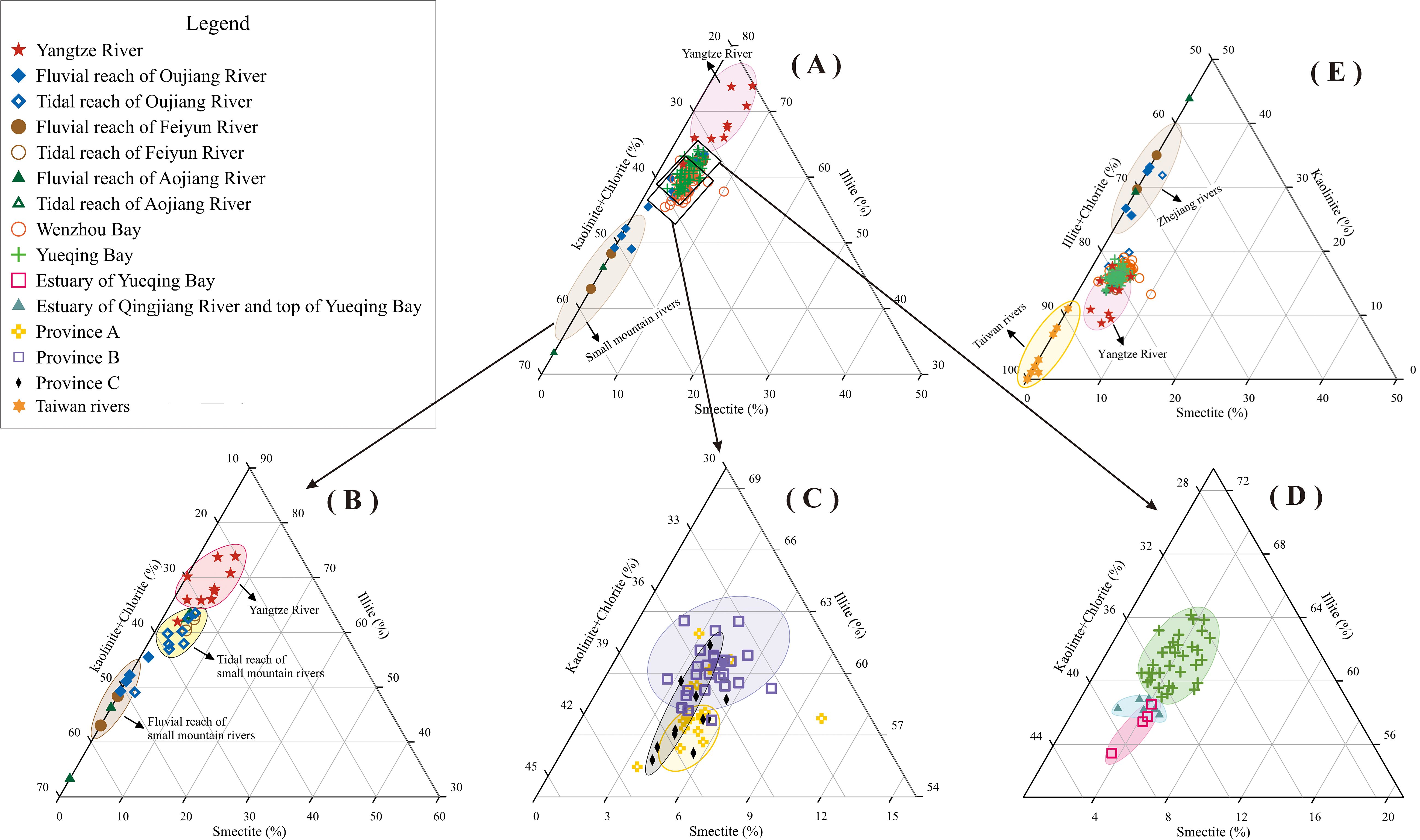
Figure 5. The ternary diagram shows the distribution of illite, smectite, and the combined presence of kaolinite and chlorite in the study area. The clay mineral distribution in surface sediments from the offshore area of the Oujiang River Estuary (A), small mountain rivers in Zhejiang Province (B), Wenzhou Bay (C), and Yueqing Bay (D). (E). Comparison of clay mineral assemblages among the Oujiang River Estuary, the Yangtze River, the Zhejiang rivers, and the Taiwan rivers. Clay mineral data for the Taiwan rivers are sourced from Xu K. et al. (2009), Xu et al. (2013); Liu et al. (2008) and Li et al. (2012). Clay minerals data sources of the Yangtze River are presented in Table 1.
The sediment in different parts of rivers contains varying concentrations of clay minerals. For example, the Oujiang, Feiyunjiang, and Aojiang Rivers all have different levels of these minerals in their surface sediments. In the upper tidal reaches, there is a high concentration of kaolinite + chlorite, averaging around 50%. On the other hand, the illite content is lower, and the smectite content is almost negligible. As you move into the tidal reaches, the concentration of kaolinite + chlorite decreases to approximately 40%, while the content of illite and smectite increases. This suggests that the sediments in the tidal reaches of these rivers have a mixed origin from both the upper reaches and nearshore regions, with their clay mineral compositions gradually becoming more similar to those of the Yangtze River. These rivers are all macro tidal estuaries and are significantly affected by semidiurnal tides, which help transport a considerable amount of fine-grained sediment from nearshore regions into the river channels through tidal pumping. Previous research also found this phenomenon in the Oujiang River tidal reach (Ma et al., 2010; Yang, 1995). In the estuaries of the Fly and Mekong rivers, where tidal influence is pronounced, it has been observed that tidal effects also transport offshore sediments into the downstream river channels (Gugliotta et al., 2017; Ogston et al., 2008). The findings are similar to those observed by previous researchers in the Mulanxi River basin in Fujian Province, China (Li et al., 2021). The authors proposed that fine-grained sediments from the Yangtze River basin can significantly affect the deposition in estuarine and tidal reaches of small mountain rivers along the southeastern coast of China, from Zhejiang to Fujian.
The provenance of the study area was delineated using clay mineral end-member characteristics (Figures 5C, D) and the geographical position of samples (Figure 6). Province A, from the Oujiang River estuary to the Dongtou Islands, has a higher content of kaolinite + chlorite and a lower content of illite, similar to nearby rivers, indicating that the sediment source is mainly influenced by the Ou River. Province B, in the central part of the area, features a higher content of illite and a lower content of kaolinite + chlorite, similar to the Yangtze River sediments, indicating that the sediments in this area are primarily from the Yangtze River. Province C, the nearshore area outside the estuary of the Oujiang River, shows a broad range of clay mineral contents, indicating a mix of sediments from the Oujiang River and those from offshore sources. Sediments in central Yueqing Bay exhibit clay mineral compositions similar to nearshore river inputs, with these sampling sites designated in Figure 6.
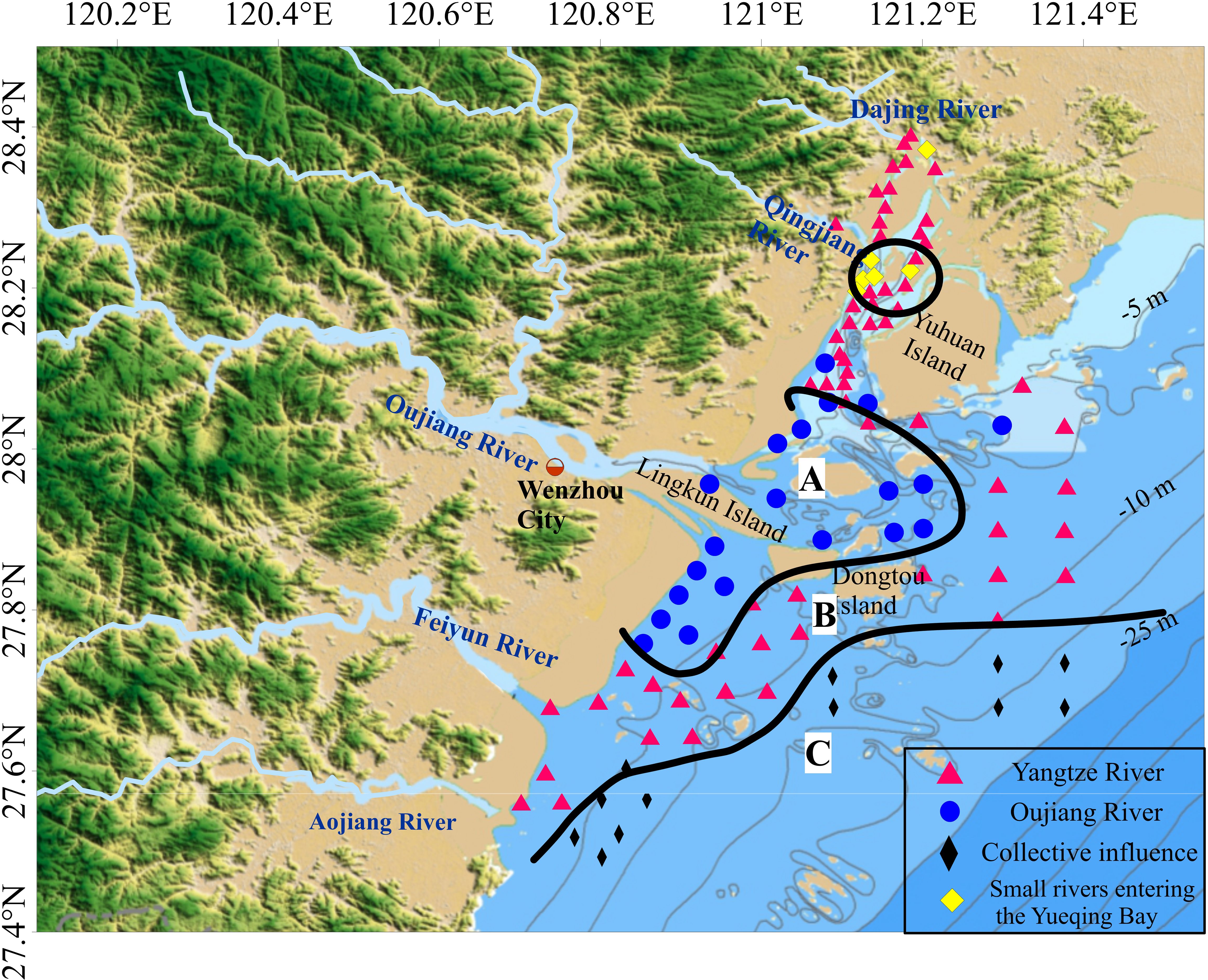
Figure 6. Zonation of surface sediment sources in the Oujiang River Estuary.
In the surface sediments of Yueqing Bay, there are three distinct sources based on the variations in clay mineral assemblages (Figure 5D). Near the Qingjiang River estuary and the top of Yueqing Bay, the sediments have high contents of kaolinite and chlorite. The areas around the Qingjiang River basin and the Dajing River basin primarily consist of intermediate to acidic volcanic rocks, which result in the production of kaolinite minerals during weathering processes. Additionally, the erosion of bedrock near Qingjiang Estuary and Yuhuan Island tends to yield chlorite (Liang et al., 2015; Wang et al., 2011). The bay’s hydrodynamic conditions allow it to retain weathering products and sediments from local rivers. The sediment near the Qingjiang Estuary and the top of Yueqing Bay contains high levels of chlorite and kaolinite due to the input of local rivers. The mouth of Yueqing Bay also has high concentrations of kaolinite and chlorite, influenced by the Oujiang River estuary and sediments from the Oujiang River. Tidal effects from the Oujiang River impact the bay’s mouth. In other regions of Yueqing Bay, there’s an increase in illite content and a decrease in kaolinite + chlorite, indicating sediments are mainly from the Yangtze River. The simulation results indicate that there is no direct water exchange between Yueqing Bay and Wenzhou Bay, consistent with the sediment study (Bao et al., 2015).
4.1.2 Provenance indications of trace elements
By collecting data on the concentrations of Cr, Sc, and Th in the surface sediments from the floodplains of the Yangtze and Oujiang River basins (Bi et al., 2017; Li et al., 2021), a Cr/Th and Sc/Th ratio diagram is applied to examine the sediment sources. In Figure 7A, the sediment samples from the Yangtze River have higher levels of Cr/Th and Sc/Th. On the other hand, the sediments from the upper Oujiang River show lower levels of Cr/Th and Sc/Th. The upper part of the Yangtze River basin has extensive outcrops of the Emeishan basalts (Yang et al., 2007), leading to higher Sc/Th ratios in the sediments due to the complex lithology of the basin. In contrast, the middle and lower parts of the basin consist mainly of granites with fewer mafic rocks, resulting in lower Sc/Th ratios in the sediments (Bi et al., 2017). In northeastern Zhejiang, the predominant rocks are Jurassic acidic volcanic rocks, whereas in southeastern Zhejiang, they are mainly Yanshanian intermediate-acidic volcanic rocks (Zhejiang Bureau of Geology and Mineral Resources, 1989). The surface sediments in the Oujiang River basin have noticeably lower Sc/Th ratios compared to those in the Yangtze River basin. The surface sediments in the offshore area of the Oujiang River Estuary show a wide range of Cr/Th and Sc/Th ratios (Figure 7A). When plotted, these sediments generally fall between those of the Yangtze River and the Oujiang River. However, most of these sediments are similar to those of the Yangtze River, suggesting that they mainly originate from the Yangtze River, with some areas being influenced by the Oujiang River. The levels of Cr/Th and Sc/Th in the Oujiang River’s tidal reach are higher compared to those upstream, indicating that the tidal effect has brought fine-grained sediments from the Yangtze River into the Oujiang River’s tidal reach.
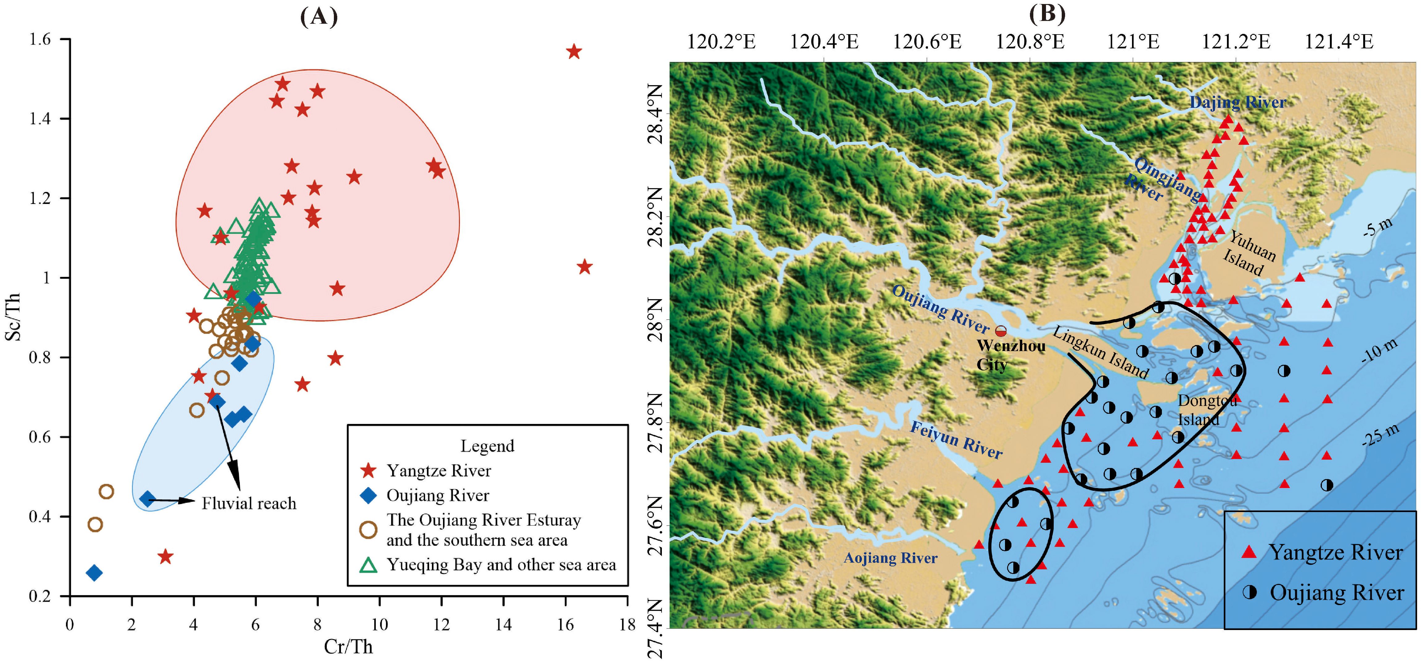
Figure 7. Discrimination diagram of Cr/Th-Sc/Th (A) and sediment source Zonation (B).
There are noticeable spatial variations in the source of surface sediments within the Oujiang River Estuary. In the estuarine and southern regions of the Oujiang River, stretching from the estuary eastward to Dongtou and southward to the Fenghuang Mountain and Feiyun River estuary areas (Figure 7B), the Cr/Th and Sc/Th values are relatively low, similar to those in the tidal reach of the Oujiang River, and some values resemble the sediments in the fluvial reach of the Oujiang River. This suggests that the surface sediments in these marine areas are primarily supplied by both the Oujiang and Yangtze Rivers, with a portion of the surface sediments originating from the Oujiang River. In the Yueqing Bay and other marine areas, the Cr/Th and Sc/Th values are higher and closer to those of the Yangtze River sediments, indicating that the source of these sediments is predominantly the Yangtze River.
Clay minerals and trace elements ratios both indicates that the deposits near the estuary are primarily derived from the Yangtze River, with the sediment in the tidal reaches of small mountain rivers also being influenced by it. Proximate sources dominate the sedimentation in the estuarine area. Clay minerals represent fine-grained sediment, while trace elements are predominantly associated with whole-rock samples. Under the influence of hydrodynamic forces, fine-grained material is transported seaward over considerable distances, potentially reaching the open ocean, whereas coarse-grained sediments primarily accumulate in the estuarine zone. Consequently, within the sediment source-to-sink system, coarse and fine-grained sediment fractions undergo distinct source-to-sink processes.
4.2 Quantification of provenance contributions
We further investigated the use of a nonlinear mathematical model to accurately measure the contributions of different sources. This helped us determine the respective impact of the Yangtze River and the Oujiang River on the clay fraction sediments in the offshore region of the Oujiang River estuary. The end-member for the Yangtze River was chosen based on the average from the Yangtze River basin. Since the upper reaches of the Oujiang River, Feiyun River, and Oujiang River have similar clay mineral content, the end-member for the small mountain rivers in Zhejiang was determined as the average of sampling sites within the upper reaches of the Oujiang River. The specific clay mineral values for these end members can be found in Table 1.
Appendix Tab 2 shows the distribution of sediments in the offshore region of the Oujiang River estuary. The clay fraction sediments in this area primarily consist of contributions from the Yangtze River and smaller coastal mountain rivers, ranging from 76% to 98%, with an average of 93%. However, at some stations, the contribution is less than 90%. These stations are mostly located on the southern flank of the offshore area of the Oujiang River estuary. In this specific area, the chlorite content exceeds 20%, which is higher than the average chlorite content for the Yangtze and Oujiang River. The sediments from the western Taiwan rivers contain a significant amount of chlorite. An upwelling zone occurs at the confluence of the Zhe-Min Coastal Current and the Taiwan Warm Current. The strong tidal dynamics in this region enhance cross-shelf sediment transport (Wu, 2015; Zeng et al., 2012). The fine-grained sediments from the west Taiwan rivers are carried into the marine environment during summer and autumn floods and are then transported northward by the cross-shelf sediment transport, finally depositing in the offshore area of southern Zhejiang Province. Therefore, Taiwan-sourced materials influence some southeastern sites of the Oujiang River estuary, but the majority of clay fraction sediments are primarily derived from the Yangtze River. The Yangtze River contributes 42% to 85% of the surface sediment in the offshore area of the Oujiang River estuary, with an average contribution of 66%. In contrast, small mountain rivers contribute 10% to 44%, with an average of 27%.
Figure 8 shows how the Yangtze River and Oujiang River contribute to the surface sediments in the offshore area of the Oujiang River estuary. The clay fraction sediment from the Yangtze River outside the Oujiang River estuary is significantly higher to the east and south of the Dongtou Island, with an average contribution of over 60%. In Yueqing Bay, the Yangtze River contributes to clay fraction sediments ranging from 48% to 85%, with an average of 68%. This suggests that clay fraction sediments from the Yangtze River are mainly deposited in Yueqing Bay and the east seas of the Oujiang River estuary.
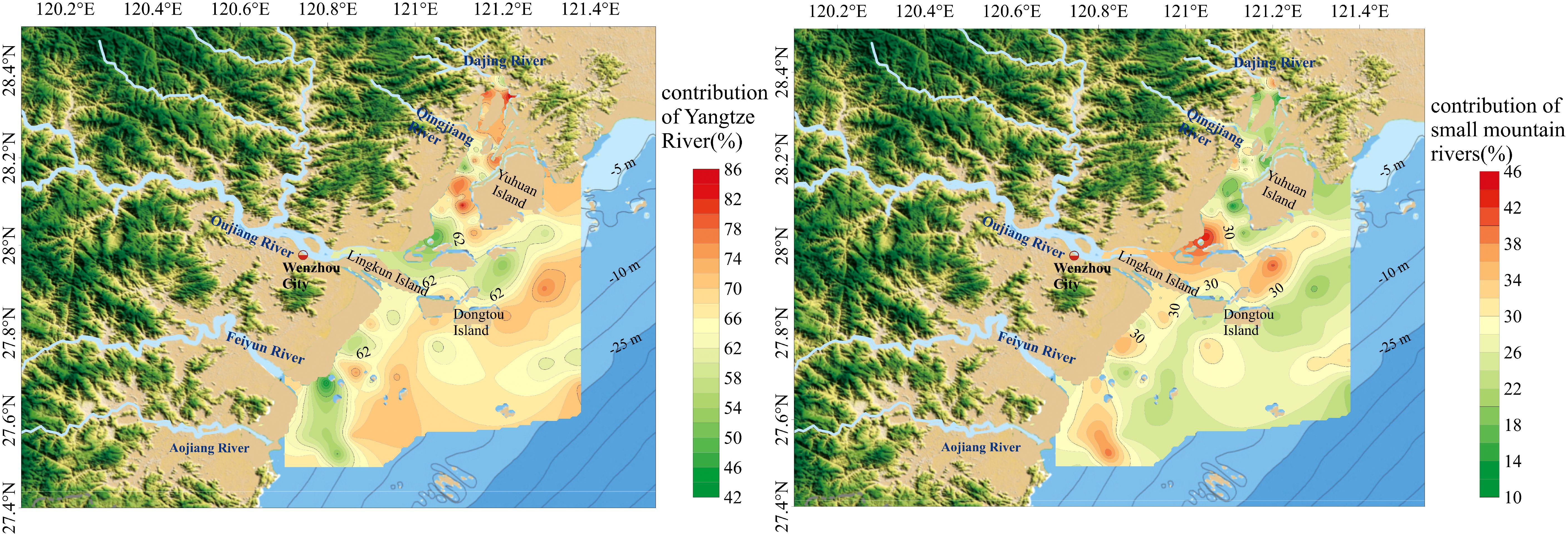
Figure 8. Map showing the contributions of the Yangtze River and the Oujiang River to the surface sediments in the study area.
The pattern is strongly influenced by the hydrodynamic conditions and sediment flux in the marine environment. The fine-grained sediments from the Yangtze River are carried southward along the coastline into Yueqing Bay by the Zhe-Min Coastal Current, and tidal effects also play a role in this process (The Editorial Committee of the Annals of Bays in China, 1993). The calculations indicate that the Yangtze River annually transports an average of approximately 2.17 × 10⁸ t of suspended sediments southward (Liu et al., 2007; Hu et al., 2012). In contrast, the annual sediment discharge into the Yueqing bay from local small rivers is only 18 × 104 t (Hu et al., 2012), and the Oujiang River contributes an annual sediment load of 266.5 × 10⁴ t. Both of these quantities are significantly less than the sediment carried southward by the Yangtze River. The clay fraction sediments contributions from small mountain rivers in Zhejiang Province to the study area are relatively higher in the regions from the Oujiang River estuary to the northern part of Dongtou, the Feiyun River estuary, and the Aojiang River estuary, accounting for approximately 30%. Zhejiang Province, located in east of the Western Pacific, is prone to frequent extreme weather events, including typhoons and storm surges (Chen et al., 2023). These events lead to heavy rainfall, causing river basin floods and the rapid transfer of materials into the marine environment (Ogston et al., 2000). The offshore waters near the estuaries of the Oujiang, Feiyun, and Aojiang Rivers receive a substantial amount of sediment from the small rivers along the coast. This river likely plays a significant role in the transport and deposition of sediment during the flood season. Sediments from the Oujiang River enter the sea and are carried southward by ocean currents, where they are then deposited along the southern shoreline (Wu et al., 2015), resulting in contributions from the small mountain rivers in Zhejiang to the nearshore waters south of the Oujiang River estuary exceeding 30%. In the central region of Yueqing Bay, especially at the Qingjiang River estuary and the head of the bay, there are significant contributions from small mountain rivers. This is believed to be caused by increased erosion of source rocks within the drainage basins of the Qingjiang and Dajingxi rivers during the flood season, leading to the transportation and deposition of their sediments in the bay.
The analysis of the sources of sediment in the offshore area of the Oujiang River estuary aligns with previous findings, confirming that the majority of surface sediments in this area originate from the Yangtze River. Sediments from the Oujiang River primarily accumulate at the estuary and the Southern coastal waters. Additionally, sediments in other marine areas are influenced to a lesser extent by nearby small mountain rivers. Previous work indicates that the Yangtze River contributes 50% to 60% of the sediment supply to the Zhe-Min mud belt, while the Oujiang River and other small rivers contribute 20% to 40% (Cong et al., 2022; Liu et al., 2014; Xu et al., 2016). Quantification of Yangtze-derived clay fraction sediment contributions to Zhejiang’s coastal system is method-dependent, with key variability introduced by (1) analytical approaches, (2) spatial sampling design, and (3) the study’s temporal resolution. Yangtze contributions scale inversely with local sediment supply, ranging from 74% in isolated shelf environments (Xue et al., 2018) to 54% near competent regional rivers (Cong et al., 2022), with further variance introduced by analytical temporal resolutions (Xiao et al., 2005; Xu et al., 2016).
Using the nonlinear mathematical model, we partitioned clay fraction sediment contributions between the Yangtze and Oujiang River sources in the offshore region of the Oujiang River estuary. Secondary sediment transport mechanisms, including resuspension processes and aeolian inputs, remain unquantified in the current budget. Sensitivity analysis of Yangtze River clay mineral end-members revealed significant control over calculated sediment contributions to the study area. This study employs ensemble-averaged clay mineral compositions from published Yangtze River datasets (Table 1) as end-members, ensuring representative source characterization and robust provenance calculations.
4.3 Hydrodynamic factors influencing sediment transport
The Taiwan Warm Current primarily resides within the 50–100 m depth range on the East China Sea shelf (Su and Pan, 1987; Zeng et al., 2012). As a result, the hydrodynamic regime of the study area is mainly influenced by the combination of the Zhe-Min Coastal Current and tidal effect.
Under the influence of the coastal current and tidal effect, the sediment transport direction is shown in Figure 9. The Zhe-Min Coastal Current, driven by the East Asian winter monsoon, flows southwestwardly that carries fine-grained sediments from the Yangtze River along the coastline in a southwestward direction (Pang et al., 2016; Zeng et al., 2012). This makes the sediments from the Yangtze River become the primary source of surface sediments in the Oujiang River estuary. In summer, sediments from the upper reaches of the Oujiang River are transported through its southern outlet, leading to deposition near the estuary (Wu et al., 2015; Du et al., 2012; Lin and Wang, 2013). The area from the estuary to Dongtou is significantly affected by sediments from the Oujiang River. Previous sediment provenance studies in the Jiaojiang and Mulanxi River estuaries have conclusively identified fine-grained Yangtze River sediments as the predominant source for these estuarine and tidal depositional systems (Li et al., 2021; Xie et al., 1988; Mai et al., 2009). Therefore, Yangtze River sediments dominate the source-to-sink processes in Zhe-Min small mountain river estuaries.
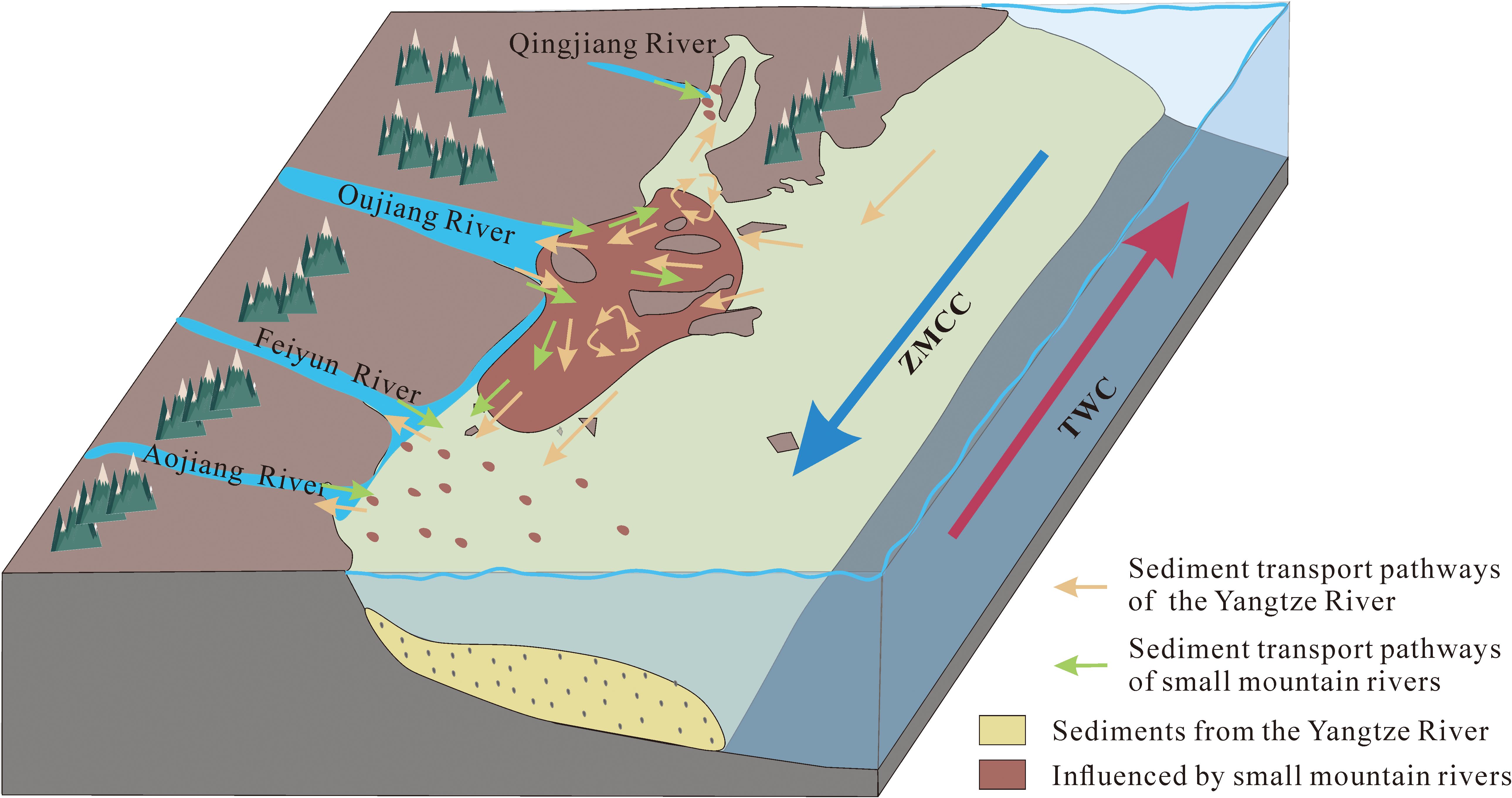
Figure 9. Map of surface sediment transport patterns and tidal current distribution in the Oujiang river estuary. (ZMCC, Zhe-Min Coastal Current; TWC, Taiwan Warm Current.).
Tidal currents also play a significant role in the transport of these sediments, shaping their distribution patterns in the shallow coastal waters of the region (Gao and Collins, 1992, 2014). The tidal influx conveys fine-grained sediments from the Yangtze River to the estuary and into the channels of smaller mountainous rivers (Shi et al., 2010). This process has a substantial impact on the mineralogical and geochemical composition of the sediments within the tidal zones of the contiguous estuaries and rivers. Previous work also found the influence of tidal effect on tidal reach in the Oujiang River by magnetic properties (Li et al., 2017).
The coastal current and tidal effect determined the frame of sediment provenance. However, the local hydrodynamic and topography conditions also influence the positions and nearby sources of sediments.
The transport of sediments on the shoal area is influenced by wind-driven surface currents (Figure 9). Fluvial sediments accumulate at the estuary in summer due to increased river discharge, while in winter, fine sediments from the offshore area (Yangtze River) are transported westward and southwestward (Du et al., 2012). The westward sediment transport encounters the tidal flat slope, causing the flow to turn northward and ultimately enter Yueqing Bay. Within Yueqing Bay, suspended sediments are directed inward toward the bay, while southwestward sediment transport is carried southward along the coastline (Xing et al., 2013; Jiang et al., 2009). As a result, sediments from the Oujiang River are predominantly deposited in the shallow marine region south of the estuary, while the sediments within Yueqing Bay consist mainly of materials sourced from the Yangtze River. Cong et al. (2022) suggested that sediments from the Oujiang River were mostly deposited south of the Oujiang River estuary by the distribution of suspended sediment concentration on the inner shelf of the East China Sea.
The suspended sediment transport pathways were influenced by the multi-island topography in the Oujiang Estuary (Figure 9). Niyu Island has a counterclockwise eddy on its southwestern side, while a clockwise eddy with reduced flow velocity is observed on the southern side of Yuhuan Island (Lin and Wang, 2013). The elemental and mineralogical composition of the sediment varies due to the influence of island topography or bedrock erosion in the local marine area.
5 Conclusion
The study used clay mineral contents and stable elemental ratios to analyze the origin and factors influencing surface sediments in the offshore area of the Oujiang River Estuary. The sediments in this area are mostly from the Yangtze River, with contributions from other sources. The clay minerals in the surface sediments are mainly illite, concentrated in Yueqing Bay and the central offshore region. Kaolinite and chlorite are also present, while smectite is found in the lowest concentrations. Among the elements analyzed, Cr has the highest average content in the surface sediments. The distribution of Cr and Sc differs from that of Th, suggesting varying sources for these elements. The study concludes that clay fraction sediments in the offshore area come primarily from the Yangtze River, with contributions from small mountain rivers. The sediments in the Estuary and southern sea area are influenced by both the Yangtze River and the Oujiang River. Additionally, other areas primarily receive sediment from the Yangtze River. Overall, the study shows that fine-grained sediment transported by large rivers significantly impacts the composition of surface sediments in estuarine and bay areas.
Data availability statement
The original contributions presented in the study are included in the article/Supplementary Material. Further inquiries can be directed to the corresponding author/s.
Author contributions
XG: Formal Analysis, Writing – original draft, Writing – review & editing. PY: Project administration, Supervision, Writing – review & editing. KC: Investigation, Writing – review & editing. FG: Investigation, Methodology, Writing – review & editing. YT: Data curation, Writing – review & editing. XH: Project administration, Supervision, Writing – review & editing. BC: Investigation, Writing – review & editing. ML: Software, Writing – review & editing. JL: Writing – review & editing.
Funding
The author(s) declare that financial support was received for the research and/or publication of this article. This research was funded by the Project of National Key Research and Development Program of China (2022 YFF0800504) and National Natural Science Foundation of China (Grant No. 42176054). The samples and data in this research were provided by the Global Earth Observation on Asian Delta and Estuary Corresponding to Anthropogenic Impacts and Climate Changes (2019YFE0127200).
Acknowledgments
We thank Professor Zhongxin Chu from the Ocean University of China for providing useful suggestions for this research. We thank the laboratory staff for their assistance during the sample testing stage.
Conflict of interest
The authors declare that the research was conducted in the absence of any commercial or financial relationships that could be construed as a potential conflict of interest.
Generative AI statement
The author(s) declare that no Generative AI was used in the creation of this manuscript.
Publisher’s note
All claims expressed in this article are solely those of the authors and do not necessarily represent those of their affiliated organizations, or those of the publisher, the editors and the reviewers. Any product that may be evaluated in this article, or claim that may be made by its manufacturer, is not guaranteed or endorsed by the publisher.
Supplementary material
The Supplementary Material for this article can be found online at: https://www.frontiersin.org/articles/10.3389/fmars.2025.1561138/full#supplementary-material
References
Bao M., Bao X., Yu H., and Ding Y. (2015). Tidal characteristics in the Wenzhou offshore waters and changes resulting from the Wenzhou Shoal Reclamation Project. J. Ocean Univ. China 14, 931–940.
Bao X., Lin X., Wu D., and Shan F. (2005). Simulation and analysis of shelf circulation and its seasonal variability in the East China Sea. Periodical ocean Univ. China 35, 349–356.
Bi L., Yang S., Li C., Guo Y., Wang Q., Liu J., et al. (2015). Geochemistry of river-borne clays entering the East China Sea indicates two contrasting types of weathering and sediment transport processes. Geochem. Geophys. Geosyst. 16, 3034–3052. doi: 10.1002/2015GC005867
Bi L., Yang S. Y., Zhao Y., Wang Z. B., Dou Y. G., Li C., et al. (2017). Provenance study of the Holocene sediments in the Changjiang (Yangtze River) estuary and inner shelf of the East China sea. Quaternary International 441, 147–161.
Biscaye P. E. (1965). Mineralogy and sedimentation of recent deep-sea clay in the atlantic ocean and adjacent seas and oceans. GSA Bull. 76, 803–832.
Blair N. E. and Aller R. C. (2012). The fate of terrestrial organic carbon in the marine environment. Annu. Rev. Marine Sci. 4, 401–423.
Chen W., Liu W., Liang H., Jiang M., and Dai Z. (2023). Response of storm surge and M2 tide to typhoon speeds along coastal Zhejiang Province. Ocean Eng. 270, 113646.
Condie K. C. and Wronkiewicz D. J. (1990). The Cr/Th ratio in Precambrian pelites from the Kaapvaal Craton as an index of craton evolution. Earth Planetary Sci. Lett. 97, 256–267. doi: 10.1016/0012-821X(90)90046-Z
Cong J., Zhang Y., Hu G., Mi B., Kong X., Xue B., et al. (2022). Textures, provenances, and transport patterns of sediment on the inner shelf of the East China Sea. Continental Shelf Res. 232, 104624.
Du P., Zhang B., and Fei Y. (2012). Discussion on characteristics of suspended sediment transport and source in sea area adjacent Wenzhou Oufei Shoal. J. Sediment Res., 65–74.
Fan D., Sun X., Yang Z., and Guo Z. (2002). A Mathematical Model on the Quantitative Provenance Identification——Take the identification of the surface sediment sources from ECS as example. Acta sedimentologica Sin. 20, 30–33.
Fan D., Yang Z., Mao D., and Guo Z. (2001). Clay minerals and geochemistry of the sediments from the Yangtze and Yellow Rivers. Marine geology quaternary geology. 21, 7–12. doi: 10.16562/j.cnki.0256-1492.2001.04.002
Gao S. and Collins M. (1992). Net sediment transport patterns inferred from grain-size trends, based upon definition of “transport vectors. Sedimentary Geology 81, 47–60.
Gao S. and Collins M. B. (2014). Holocene sedimentary systems on continental shelves. Marine Geology 352, 268–294.
Ghosh S. and Sarkar S. (2010). Geochemistry of Permo-Triassic mudstone of the Satpura Gondwana basin, central India: Clues for provenance. Chem. Geology 277, 78–100.
Guan W., Kot S., and Wolanski E. (2005). 3-D fluid-mud dynamics in the Jiaojiang Estuary, China. Estuarine Coastal Shelf Sci. 65, 747–762.
Gugliotta M., Saitoa Y., Nguyenc V. L., Tac T. K. O., Nakashimaa R., Tamuraa T., et al. (2017). Process regime, salinity, morphological, and sedimentary trends along the fluvial to marine transition zone of the mixed-energy Mekong River delta, Vietnam. Continental Shelf Res. 147, 7–26.
He M., Zheng H., Huang X., Jia J., and Li L. (2011). Clay mineral assemblages in the Yangtze drainage and provenance implications. Acta sedimentologica Sin. 29, 544–551.
Hu C., Wang Y., Chen S., and He Q. (2012). The variation of coastal-sediment on the coast line in Zhejiang Province and its impact on the variation of shoals. Zhejiang Hydrotechnics, 1–4. doi: 10.13641/j.cnki.33-1162/tv.2012.06.005
Jian X., Yang S., Hong D., Liang H., Zhang S. H., Fu H., et al. (2020a). Seasonal geochemical heterogeneity of sediments from a subtropical mountainous river in SE China. Marine Geology 422, 106120.
Jian X., Zhang W., Yang S., and Kao S. (2020b). Climate-dependent sediment composition and transport of mountainous rivers in tectonically stable, subtropical East Asia. Geophysical Res. Lett. 47, e2019GL086150.
Jiang H., Shen Y., and Wang S. (2009). Numerical simulation study on three-dimensional tidal flow and salinity in the Oujiang Estuary. J. Hydrodynamics 24, 63–70.
Leithold E. L., Blair N. E., and Wegmann K. W. (2016). Source-to-sink sedimentary systems and global carbon burial: A river runs through it. Earth-Science Rev. 153, 30–42.
Li W., Hu Z. H., Zhang W., Ji R., and Nguyen T. H. (2017). Influence of provenance and hydrodynamic sorting on the magnetic properties and geochemistry of sediments of the Oujiang River, China. Marine Geology 387, 1–11.
Li Y., Huang X., Hiep N. T., Lian E., and Yang S. (2021). Disentangle the sediment mixing from geochemical proxies and detrital zircon geochronology. Marine Geology 440, 106572.
Li Y., Huang X., Lian E., Li C., Xu J., Yin P., et al. (2023). Geochemical and provenance heterogeneity of small mountainous river systems in Southeast China. Global Planetary Change 230, 104271.
Li C. S., Shi X. F., Kao S. J., Chen M. T., Liu Y. G., Fang X. S., et al. (2012). Clay mineral composition and their sources for the fluvial sediments of Taiwanese rivers. Chin Sci. Bull. 57, 673681.
Li A. and Zhang K. (2020). Research progress of mud wedge in the inner continental shelf of the East China Sea. Oceanologiaet limnologia Sin. 51, 705–727.
Liang X., Yang S., Yin P., and Zhao Y. (2015). Distribution of clay mineral assemblages in the rivers entering Yellow Sea and East China Sea and the muddy shelve deposits and control factors. Marine geology quaternary geology 35, 1–15.
Lin C. (1988). Quantity and transport of sediment at the Yangtze River estuary. Sci. China,Ser.A, 89–101.
Lin C. (1989). A study on the source and quantity of sediment at the Yangtze River estuary. Acta geographica Sin. 44, 22–31.
Lin W. and Wang Y. (2013). Study on characteristics of suspended sediment transport in Oujiang river estuary. J. hydroelectric Eng. 32, 119–128.
Liu D. (2019). Study on the Evolution of the Liaohe – Daling River Delta in the Past Four Hundred Years (Beijing: China University of Geosciences) p. 132-142.
Liu Z., Colin C., Li X., Zhao Y., Tuo S., Chen Z. H., et al. (2010). Clay mineral distribution in surface sediments of the northeastern South China Sea and surrounding fluvial drainage basins: Source and transport. Marine Geology 277, 48–60.
Liu J., Lu Y., Zuo L., Liu H., Xu Q., and Hou Q. (2022). Morphologic evolution of bifurcated reaches in a macrotidal estuary with mountain streams. Int. J. Sediment Res. 37, 857–870.
Liu S., Shi X., Fang X., Dou Y., Liu Y., and Wang X. (2014). Spatial and temporal distributions of clay minerals in mud deposits on the inner shelf of the East China Sea: Implications for paleoenvironmental changes in the Holocene. Quaternary Int. 349, 270–279.
Liu Z., Tuo S., Colin C., Liu J. T., Huang C. Y., Selvaraj K., et al. (2008). Detrital fine-grained sediment contribution from Taiwan to the northern South China Sea and its relation to regional ocean circulation. Mar. Geol. 255, 149–155.
Liu J., Xu K., Li A., Milliman J., Velozzi D., Xiao S., et al. (2007). Flux and fate of Yangtze River sediment delivered to the East China Sea. Geomorphology 85, 208–224.
Liu Z., Zhao Y., Colin C., Stattegger K., Wiesner M. G., Huh C., et al. (2016). Source-to-sink transport processes of fluvial sediments in the South China Sea. Earth-Science Rev. 153, 238–273.
Ma C., Chen J., Zhou Y., and Wang Z. (2010). Clay minerals in the major Chinese coastal estuaries and their provenance implications. Front. Earth Sci. China. 4, 449–456.
Mai M., Yan Y., and Wu Y. (2009). Analysis on hydrographical environment and seabed morphological processes characteristics in Taizhou Bay. J. Waterway Harbor 30, 246–252.
McLennan S. M., Taylor S. R., and Eriksson K. A. (1983). Geochemistry of archean shales from the pilbara supergroup, Western Australia. Geochimica Cosmochimica Acta 47, 1211–1222.
Milliman J. D. and Farnsworth K. L. (2011). River Discharge to the Coastal Ocean: A Global Synthesis (Cambridge: Cambridge University Press).
Nittrouer C. A., Austin J. A., Field M. E., Kravitz J. H., Syvitski J. P.M., and Wiberg P. L. (2007). Continental Margin Sedimentation: From Sediment Transport to Sequence Stratigraphy (International Association of Sedimentologists). doi: 10.1002/9781444304398
Ogston A. S., Cacchione D. A., Sternberg R. W., and Kineke G. C. (2000). Observations of storm and river flood-driven sediment transport on the northern California continental shelf. Continental Shelf Res. 20, 2141–2162.
Ogston A. S., Sternberg R. W., Nittrouer C. A., Martin D. P., Goni M. A., and Crockett. J. S. (2008). Sediment delivery from the Fly River tidally dominated delta to the nearshore marine environment and the impact of El Niño. J. Geophysical Res.: Earth Surface 113, F01S11.
Pang C., Li K., and Hu D. (2016). Net accumulation of suspended sediment and its seasonal variability dominated by shelf circulation in the Yellow and East China Seas. Marine Geology. 371, 33–43.
Pei X. (1991). Multivariate statistics and its applications (Beijing: China Agricultural University Press).
Ren M. E. and Shi Y. L. (1986). Sediment discharge of the Yellow River (China) and its effect on the sedimentation of the Bohai and the Yellow Sea. Cont. Shelf Res. 6, 785–810.
Shi X., Liu S., Qiao S., Liu Y., Fang X., Wu Z., et al. (2010). Depositional features and palaeoenvironmental records of the mud deposits in Min-Zhe coastal mud area, East China Sea. Marine geology quaternary geology 30, 19–30.
Singh P. (2009). Major, trace and REE geochemistry of the Ganga River sediments: Influence of provenance and sedimentary processes. Chem. Geology 266, 242–255.
Song H., Liu J., Yin P., Zhang Y., and Chen X. (2018). Characteristics of heavy minerals and quantitative provenance identification of sediments from the muddy area outside the oujiang estuary since 5.8 kyr. J. Ocean Univ. China 17, 1325–1335.
Sun S., Li Y., Liu D., and Hu K. (2022). Clay mineralogical records in the north bohai coast of China in the last century: sediment provenance and morphological implications. Front. Earth Sci. 10, 865839.
Taylor S. R. and McLennan S. M. (1995). The geochemical evolution of the continental crust. Rev. Geophysics 33, 241–265.
The Editorial Committee of the Annals of Bays in China (1993). The annals of Bays in China (Beijing: Ocean Press).
Vital H. and Stattegger K. (2000). Major and trace elements of stream sediments from the lowermost Amazon River. Chem. Geology 168, 151–168.
Walsh J. P., Wiberg P. L., Aalto R., Nittrouer C. A., and Kuehl S. A. (2016). Source-to-sink research: economy of the Earth’s surface and its strata. Earth-Science Rev. 153, 1–6.
Wang H., Liu Z., Sathiamurthy E., Li J., and Zhao Y. (2011). Chemical weathering in Malay Peninsula and North Borneo: Clay mineralogy and element geochemistry of river surface sediments. Sci. China Earth Sci. 41, 205–215.
Wei G., Liu Y., Li X., Shao L., and Fang D. (2004). Major and trace element variations of the sediments at ODP Site 1144, South China Sea, during the last 230 ka and their paleoclimate implications. Palaeogeography Palaeoclimatology Palaeoecol. 212, 331–342.
Wu H. (2015). Cross-shelf penetrating fronts: A response of buoyant coastal water to ambient pycnocline undulation. J. Geophys. Res. Oceans 120, 5101–5119.
Wu C., Huang S. H., Luo X., Mu J., and Zhao X. (2015). Characteristics of surface sediment grain size in Oufei Shoal and adjacent sea area and hydrodynamic responses. Marine Sci. Bull. 34, 399–406.
Xiao S.H., Li A., Jiang F., You Z. H., and Chen L. (2005). Provenance analysis of mud along the Min-Zhe coast since 2 Ka BP. Acta Sedimentologica Sinca. 23, 268–274.
Xiao S., Li A., Liu W., Zhao J., and Xu F. (2009). Analysis of the provenance of muddy sediments along the Zhe-Min coastline. Process Nat. Sci. 19, 185–191.
Xie Q., Zhang L., and Li B. (1988). Analysis of accumulation in the Taizhou Bay. Donghai Marine Sci. 6, 25–33.
Xing Y., Ai C., and Jin S. H. (2013). A three-dimensional hydrodynamic and salinity transport model of estuarine circulation with an application to a macrotidal estuary. Appl. Ocean Res. 39, 53–71.
Xu D. Y. (1983). “Mud sedimentation on the East China Sea shelf,” in Proceedings of International Symposium on Sedimentation on the Continental Shelf with Special Reference to the East China Sea, April 12–16, 1983 (China Ocean Press, Hangzhou), 506–516.
Xu Y., Chen J., Wang A., Li Y., Wang W., Zhang X., et al. (2013). Clay minerals in surface sediments of the Taiwan strait and their provenance. Acta Sedimentologica Sin. 31, 120–129.
Xu F., Li A., Li T., Chen S. H., Cao Y., Dong C. H., et al. (2011a). Provenance of mud sediments in the inner shelf of East China Sea since mid-Holocene. J. China Univ. Petroleum 35, 1–6+12.
Xu F., Li A., Li T., Xu K., Chen S., Qiu L., et al. (2011b). Rare earth element geochemistry in the inner shelf of the East China Sea and its implication to sediment provenances. J. Rare Earths 29, 702–709.
Xu F., Li A., Xiao S., Wan S., Liu J., and Zhang Y. (2009). Paleoenvironmental evolution in the inner shelf of the East China Sea since the last Deglaciation. Acta Sedimentologica Sin. 27, 118–127.
Xu G., Liu J., Liu S. H., Wang Z. H., Hu G., and Kong X. (2016). Modern muddy deposit along the Zhejiang coast in the East China Sea: Response to large-scale human projects. Continental Shelf Res. 130, 68–78.
Xu K., Milliman J. D., Li A., Liu J. P., Kao S. J., and Wan S. H. (2009). Yangtze- and Taiwan-derived sediments on the inner shelf of East China Sea. Continental Shelf Res. 29, 2240–2256.
Xu T. and You X. (2017). Numerical simulation of suspended sediment concentration by 3D coupled wave-current model in the Oujiang River Estuary, China. Continental Shelf Res. 137, 13–24.
Xue C., Jia J., Gao S., Cai T., Chao H., Li L., et al. (2018). The contribution of middle and small rivers to the distal mud of subaqueous Changjiang Delta: results from Jiaojiang River and Oujiang River. Haiyang Xuebao 40, 75–89.
Yang Z. (1988). Mineralogical assemblages and chemical characteristics of clays from sediments of the Huanghe, Changjiang, Zhujiang Rivers and their relationship to the climate environment in their sediment sources areas. Oceanologia limnologia Sin. 19, 336–346.
Yang X. S. (1995). Clay minerals of suspended sediments in Oujiang river. Mar. Sci. Bull. 14, 86–92.
Yang S., Bi L., Li C., Wang Z., and Dou Y. (2016). Major sinks of the Changjiang (Yangtze River)-derived sediments in the East China Sea during the late Quaternary. Geological Soc. London Special Publications 429, 137–152.
Yang S. Y., Jiang S. Y., Ling H. F., Xia X. P., Sun M., and Wang D. J. (2007). Sr-Nd isotopic compositions of the Changjiang sediments: implications for tracing sediment sources. Sci. China Ser. D Earth Sci. 50, 1556–1565.
Yang S. Y., Jung H. S., Lim D. I., and Li C. X. (2003). A review on the provenance discrimination of sediments in the Yellow Sea. Earth-Science Rev. 63, 93–120.
Zeng D., Ni X., and Huang D. (2012). Temporal and spatial variability of the Zhe-Min Coastal Current and the Taiwan Warm Current in winter in the southern Zhejiang coastal sea. Sci. Sin. Terrae 42, 1123–1134.
Zhao Y., Zou X., Gao J., Wang C., Li Y., Yao Y., et al. (2018). Clay mineralogy and source-to-sink transport processes of Changjiang River sediments in the estuarine and inner shelf areas of the East China Sea. J. Asian Earth Sci. 152, 91–102.
Zhejiang Bureau of Geology and Mineral Resources (1989). Survey of regional geology in Zhejiang Province (Beijing: Geological Publishing House).
Keywords: offshore waters of the Oujiang River estuary, clay minerals, trace elements, provenance analysis, source-to-sink processes, The Yangtze River
Citation: Guang X, Yin P, Cao K, Gao F, Tian Y, Huang X, Chen B, Li M and Liu J (2025) Impact of the Yangtze River on Sediment source-to-sink processes in estuarine bays: a study of the Oujiang River Estuary, SE China. Front. Mar. Sci. 12:1561138. doi: 10.3389/fmars.2025.1561138
Received: 15 January 2025; Accepted: 21 May 2025;
Published: 19 June 2025.
Edited by:
Yifei Zhao, Nanjing Normal University, ChinaReviewed by:
Jian Zhou, Hohai University, ChinaJing Chen, East China Normal University, China
Zhongbo Wang, Shantou University, China
Xueshi Sun, Ocean University of China, China
Lingling Zhu, Changjiang Water Resources Commission, China
Copyright © 2025 Guang, Yin, Cao, Gao, Tian, Huang, Chen, Li and Liu. This is an open-access article distributed under the terms of the Creative Commons Attribution License (CC BY). The use, distribution or reproduction in other forums is permitted, provided the original author(s) and the copyright owner(s) are credited and that the original publication in this journal is cited, in accordance with accepted academic practice. No use, distribution or reproduction is permitted which does not comply with these terms.
*Correspondence: Ping Yin, cGluZ3lpbkBmaW8ub3JnLmNu