 Gang Liu1,2
 Wanli Chen
 Shiguo Wu
- 1Key Laboratory of Marine Geology Resources and Environment of Hainan Province, Haikou, China
- 2Marine Geological Survey Institute of Hainan Province, Haikou, China
- 3Institute of Deep-Sea Science and Engineering, Chinese Academy of Sciences, Sanya, China
- 4Sanya Institute of South China Sea Geology, Guangzhou Marine Geological Survey, Sanya, China
Carbonate slopes and their associated relocated deposits are of significant interest due to their potential as hydrocarbon reservoir. This study investigates the geomorphology and depositional processes of carbonate slopes in the semi-enclosed Xuande Atoll, South China Sea, using high-resolution acoustic data, seismic profiles, and topographic analysis. Our results reveal that the modern morphology of the carbon slope is shaped by depositional and erosive processes that differ markedly between the windward (northeastern) and leeward (southwestern) slopes. The wind-related asymmetric facies distribution on the platform top drives distinct slope geomorphologies. On the windward slope, mass-transport complexes (MTCs) exhibit limited transport distances or remnant deposits, likely due to the influence of coarse and heavy sediments sourced from reef flats, transported as calcidebrites. Additionally, drift sedimentation on the windward slope indicates the impact of contour currents. In contrast, the leeward slope is characterized by gullies and channels, suggesting that fine and light carbonate sediments from the interior platform were transported by wind-driven currents as calciturbidites, cutting the slope. Most MTCs on the leeward slope exhibit long-distance transportation, closely associated with the input of fine and light carbonate sediments from the interior platform. We demonstrate that wind-related asymmetric facies distribution and sediment export are key factors contributing to the pronounced contrast in the windward and leeward slope geomorphologies of Xuande Atoll. The combination of processes results in spatially heterogeneous sedimentation on both the top and slope of the platform, which has significant implications for understanding reservoir heterogeneity and predicting hydrocarbon distribution in ancient carbonate platforms.
1 Introduction
Isolated carbonate platforms (ICPs) are commonly influenced by prevailing winds, resulting in distinct facies distributions between the windward and leeward sides, as extensively documented in previous studies (Purdy and Gischler, 2005; Reijmer et al., 2009; Jorry et al., 2016; Wu et al., 2020; Droxler and Jorry, 2021; Fauquembergue et al., 2024). However, the relationship between the facies distribution on the platform top and slope deposition remains an enigma, warranting further investigation. The significance of this knowledge gap cannot be overstated, particularly because carbonate reservoirs play a pivotal role in global oil reserves, accounting for approximately 60% of the world’s total petroleum resources, making the understanding of carbonate slope deposition absolutely essential. Coarse-grained sediments exported from the platform top serve as a crucial source for the deep-water environment and have the potential to form hydrocarbon reservoirs, exemplified by the Tengiz Field in Kazakhstan (Collins et al., 2014). Moreover, carbonate reservoirs are attractive options for CO2 sequestration, given that a significant portion of the world’s oil reserves are held within carbonate rocks (Matter and Kelemen, 2009; Siqueira et al., 2017; Sun et al., 2017; Peter et al., 2022). Therefore, studying the youngest carbonate slope sedimentation, influenced by known Pliocene–Quaternary processes, provides valuable insights into the coeval platform top and basinal settings, which is of great significance for carbonate reservoir exploration, as highlighted in various works (Wunsch et al., 2017; J. Liu et al., 2022; Petrovic et al., 2023).
Carbonate slope deposition is intrinsically linked to carbonate production on the platform top, offering key information about the associated carbonate factory and the factors controlling platform evolution. For instance, Wolfgang Schlager (1994) proposed the concept of “highstand shedding,” suggesting that carbonate depositional systems shed most sediment into adjacent basins during sea-level highstands, while no sediment is exported during lowstands due to the cessation of platform growth. This concept is particularly relevant to the Quaternary, where during the Quaternary, with significant cyclic sea-level changes, the flooding and exposure cycles of the shallow-water sedimentary environment were clearly reflected in carbonate slope deposition, as demonstrated by Alonso-Garcia et al. (2024).
Numerous studies have explored various aspects of carbonate slope depositional systems, including morphology, sedimentary processes, dynamics, and internal stratigraphic architecture (Betzler et al., 2014; Principaud et al., 2015; Chabaud et al., 2016; Principaud et al., 2018; Wunsch et al., 2018; Mulder et al., 2019; Peyrotty et al., 2020; Recouvreur et al., 2020; J. Liu et al., 2022; Wu, 2022; Yu et al., 2022; Petrovic et al., 2023). For example, Betzler et al. (2014) documented the interplay between off-bank sediment exports and ocean currents, resulting in peri-platform drift. Principaud et al. (2018) showed how density cascading flows and bottom currents shape the recent morphology and sedimentary processes along the western slope of the Great Bahama Bank (GBB). Principaud et al. (2015) illustrated the internal architecture and dynamic evolution of four distinct carbonate mass transport complexes (MTCs) along the northwestern slope of the GBB. While these studies collectively highlight the additional influence of bottom and contour currents on slope stability and sedimentation, the influence of monsoonal dynamics on sediment transport and slope morphology remains poorly understood. Our study addresses this gap by investigating the Xuande Atoll, a unique setting in the SCS where monsoonal winds play a critical role in shaping slope asymmetry and sedimentation patterns.
Although the mechanisms of carbonate production on the platform and the characteristics such as morphology, sedimentary processes, sedimentary dynamics, and internal stratigraphic architecture around the carbonate platform are well understood, questions remain regarding the transport and dispersion of sediment from carbonate production areas to carbonate slopes. To address these questions, in this study, we describe the various types of slope deposition on windward and leeward slopes, elucidating the connection between the shallow-water realm and carbonate slope deposition. Secondly, with a focus on the sedimentary inventory of the youngest sequence formed since 5.3 Ma, we explore its diversity and complexity to establish a link between platform-top sedimentation and sedimentary processes on different platform slopes. Finally, a sedimentary model is developed to account for the complex sediment distribution and the presence of distinct sedimentary structures and features on different platform slopes. This study aims to clarify the role of platform top facies distribution and sediment export in distinct slope depositions, thereby providing new insights into carbonate platform slope depositional systems in other regions, such as the Indo-Pacific region.
2 Geologic and oceanographic setting of the study area
Xuande Atoll was chosen for this study, primarily because of the large amount of existing data and published results. This atoll, with a semi-closed rim, is a typical ellipse-isolated carbonate platform located on the northern continental slope of the South China Sea (SCS) (Figure 1A) and serves as a typical sedimentary model for semi-atolls (Wu et al., 2020; Chen et al., 2021; Wei et al., 2023). Two distinct reef flats supporting several islands are well-developed on the northeastern and southeastern platform margins, with water depths ranging from 0 to 30 m. Only one small reef flat with a water depth of 25–30 m grows on the southwestern margin of the atoll. The atoll lagoon, with a maximum water depth of 60 m, is dominated by coarse-grained sand and is partly surrounded by the three reef flats (Wu et al., 2020). The lithology and stratigraphy of this platform have also been studied using seismic profiles and well XK-1 drilled in the Xuande Atoll (Wang et al., 2015; Shao et al., 2017; Wu et al., 2019; Qin et al., 2022; Y. Liu et al., 2023). The Late-Cenozoic platform strata in the Xuande Atoll, developed on Precambrian or Mesozoic metamorphic rock and Mesozoic volcanic rock basements (Zhao et al., 2011), are composed of the unconformity-bounded Sanya (Lower Miocene), Meishan (Middle Miocene), Huangliu (Upper Miocene), Yinggehai (Pliocene), and Ledong (Quaternary) formations (Figure 2). Horizon T30 (approximately 5.3 Ma), which represents the top of the Huangliu Formation, has been identified on the outcropping surface of drowning carbonate terraces (Figure 2, Qin et al., 2022), and can be applied in the stratigraphic seismic interpretation of the carbonate slope and adjacent basin.
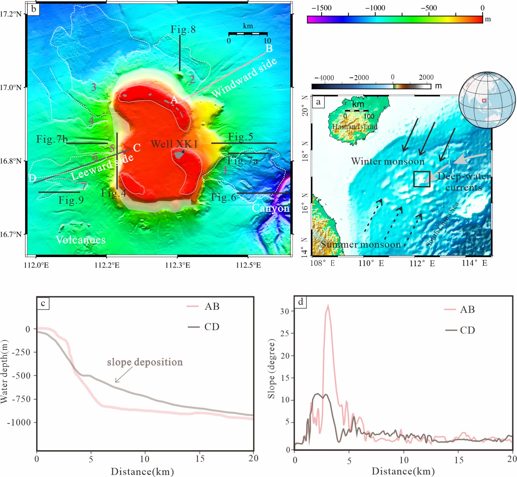
Figure 1. (a) Map of the Xuande Atoll. Yellow and purple arrows indicate the directions of winter and summer monsoon winds. Green arrows indicate the direction of deep-water circulation based on the path of sediment drifts and southwestward transportation along the northern slope of the SCS (Shao et al., 2007). (b) Bathymetric map of Xuande platform. Black lines show the location of seismic lines in this study. The grey area represents the islands on the reef flats bounded by pink lines. The white transparent area covering the upper slope of the platform is lacking in bathymetric data. Here, the data were calculated by interpolation. Representative (c) terrain and (d) slope gradient profiles on windward and leeward sides of winter wind of the platform slopes. See Figure 1B for the locations of the profiles.
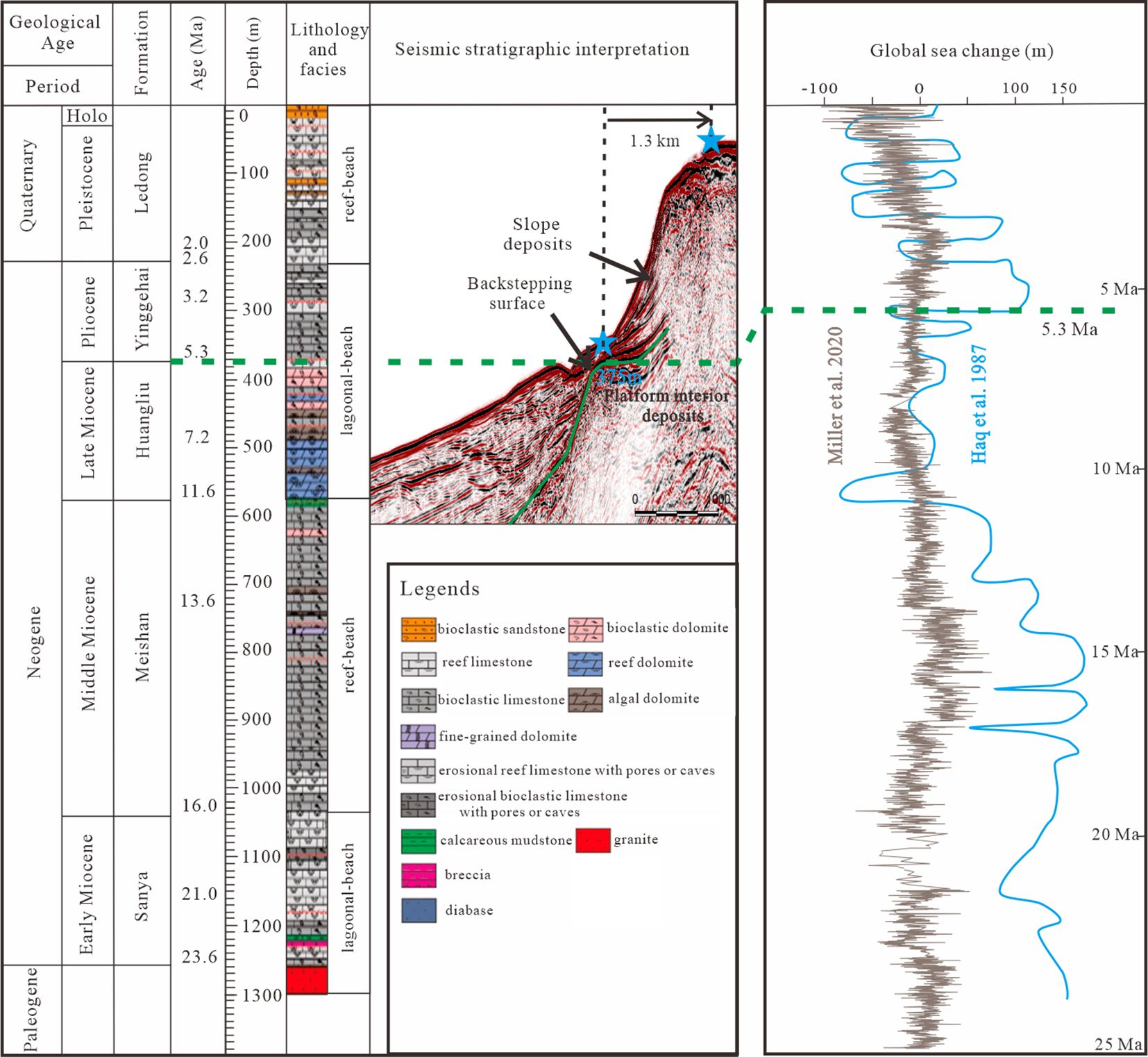
Figure 2. Stratigraphic column reconstructed from well XK-1 on the Xuande Atoll, northern SCS. Well XK-1 is located on the largest island of the Xuande Atoll (see Figure 1B). The lithology and facies were modified from Shao et al. (2017). The seismic stratigraphic interpretation was from Qin et al. (2022). The depths of the backstepping surfaces were correlated with the corresponding depths in Well XK-1 dated as 6–4 Ma (300–375 m), demonstrating that the backstepping surfaces were formed at 5.3 Ma (Qin et al., 2022). The global sea-level curves (Grey and blue line) were from Haq et al. (1987) and Miller et al. (2020).
Surface circulation in Xuande Atoll is affected by the East Asian monsoon (EAM), where southwesterly winds prevail in the summer and northeasterly winds prevail in the winter (Hu et al., 2000; Wang et al., 2011; Shu et al., 2014). Intense EAM controls surface currents and the distribution of nutrients in the northern SCS, which has been documented (Wang et al., 1999; Cheng et al., 2005). Furthermore, many geological proxies have illustrated a trend of a gradual increase in the East Asian winter monsoon (EAWM) in the SCS during the Pleistocene (Liu et al., 1999; Zhisheng et al., 2001; Wan et al., 2007). The East Asian summer monsoon (EASM), reflected by the magnetic susceptibility index, became more variable and, at times, weaker during the Pleistocene (Guo et al., 2002; Jiang et al., 2019). Deep oceanic circulation, characterized by a cyclonic circulation pattern in the SCS, originates from North Pacific Deep Water and is strongly influenced by the geomorphology of the semi-enclosed basin (Fang et al., 2009; Wang et al., 2011; Qiang et al., 2013; Shu et al., 2014; Chen et al., 2015).
3 Data and methods
Multichannel seismic reflection data were collected in August and September 2017. This represents the first seismic experiment carried out across Xuande Atoll in the South China Sea (SCS). The seismic data were acquired using the SeaMUX™ NTRS2 QAI™ Recording System, a high-resolution digital seismic acquisition system, ensuring precise and detailed data collection. The seismic source, an airgun array, was employed as the energy source, and it was configured with a minimum-phase wavelet, optimizing the temporal resolution and enhancing the interpretation of subsurface features. The source distance was set at 12.5 m, and the seismic system had a migration distance of 90 m. The streamer, with a length of 600 m, had a channel separation of 6.25 m. The data were processed using the Omega processing platform, and the original seismic data were interpreted with Geoeast Software. For all the seismic profiles presented in this study, the vertical scales are based on two-way travel times. The horizon T30 (approximately 5.3 Ma) was interpreted by correlating with the seismic stratigraphy documented by Qin et al. (2022) through interconnected seismic profiles (Figure 1B). While the seismic data provide valuable insights into the subsurface features, partial data gaps in certain areas may influence the interpretation of specific features. These gaps were carefully considered during the analysis, and interpretations were cross-validated with multibeam bathymetric data to ensure consistency.
The morphology of Xuande Atoll was recently examined through multibeam bathymetry measurements, which were conducted using a hull-mounted Kongsberg EM122 multibeam echosounder. The EM122 is a high-resolution bathymetry mapping system that operates in the 12-kHz range, with 864 simultaneous beams per ping and a swath width capable of covering up to four times the water depth. Before the multibeam bathymetry measurements, the roll, pitch, and yaw values were calibrated. The acquired data were post-processed using Caris software (Kongsberg Maritime). Sound velocity profile (SVP) was collected using a CTD profiler and applied to correct for variations in sound speed through the water column, ensuring accurate depth measurements. The SVP covered a depth range of 0 to 1387meters, with sound speeds ranging from 1484 m/s at the surface to 1509 m/s at the seabed. The processed bathymetry data achieved a spatial resolution of 100 x 100 meters, providing detailed and reliable mapping of the seafloor. The data were not adjusted for tides, which have a range of 0.5 - 1 m, and thus has a negligible impact on the overall trends observed in the data. Challenges encountered during post-processing, such as data artifacts in areas of steep slopes, were addressed by applying smoothing algorithms and cross-referencing with seismic data. The bathymetric map in Figure 1B was generated by integrating the multibeam depth soundings with the bathymetry predicted from satellite data. However, there were partial data gaps in the multibeam bathymetric data on the upper slope of Xuande Atoll. The geomorphologic parameters of MTC-1 - MTC-7 on the present seafloor, including area, headscarp water depth, headscarp height, headscarp slope, scar slope, local unfailed slope, and transport distance, were measured using Global Mapper software. The volume (V) of the MTC was calculated using the approximate wedge-shaped geometric model proposed by McAdoo et al. (2000). Specifically, the volume is determined by multiplying the area of the MTC by the headscarp height and then dividing the result by two (Table 1).
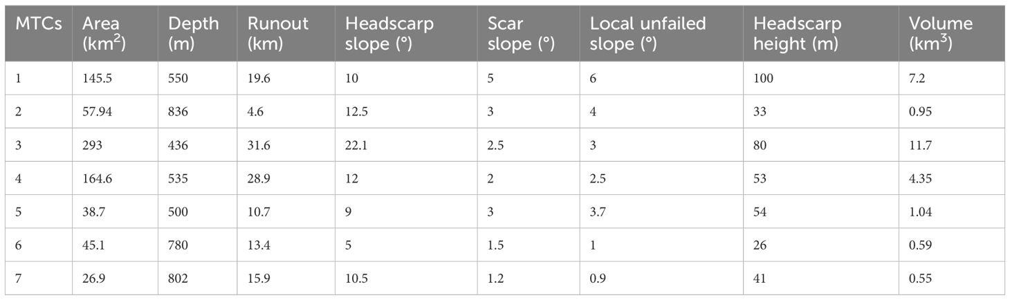
Table 1. Statistics of morphological parameters of MTCs.
4 Results and interpretation
4.1 Platform top and terraces
In plan view, Xuande Atoll exhibit an oval shape, with its longer axis oriented north–south and its shorter axis extending east–west (Figure 1B). The atoll features two prominent reef passes: a 60-m-deep, 5.6-km-wide reef pass on the east side and a 52-m-deep, 7.6-km-wide reef pass on the south side (Figures 3A, B). The western part lacks a continuous reef rim and is open to the ocean. The northeastern and southeastern slopes are relatively steep (20–30°), with sediment-starved flanks on the windward side (Figures 1C, D). In contrast, the southwestern slope (10°–25°) is less steep, with leeward deposition (Figures 1C, D). A significant feature is the carbonate terrace on the eastern slope, characterized by a 30° margin declivity and a water depth of 360 m at its edge, located approximately 8 km from the modern platform edge. Platform backstepping also occurs on the western platform, with its carbonate terrace almost covered by sediment (Figure 4). The outcropping surface of the carbonate terrace, corresponding to the 5.3 Ma platform backstepping, provides critical insights into stratigraphic interpretation and can be traced into the deep-water environment (Qin et al., 2022).
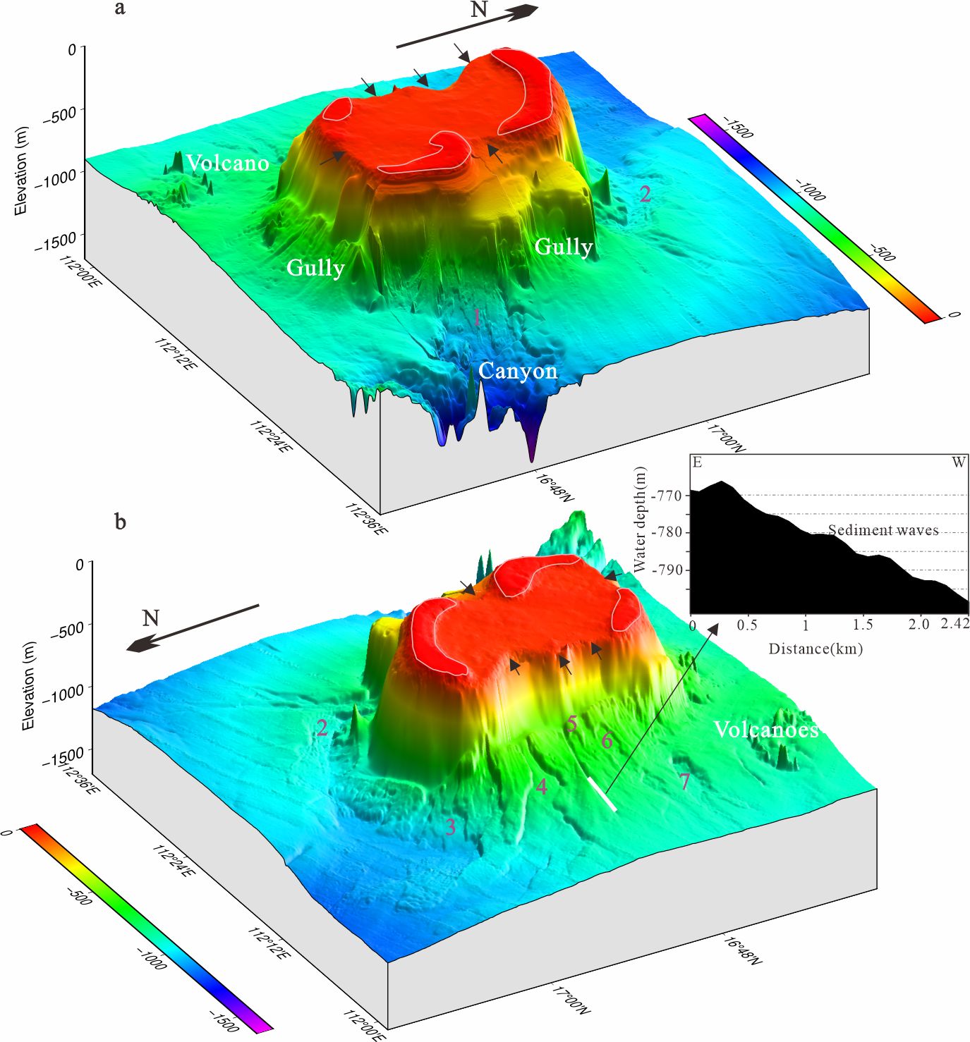
Figure 3. Three-dimensional view of the Xuande Atoll. (a) Southeastern and northeastern slopes are steep and characterized by evident carbonate terraces and slope failures. (b) Western slope is less steep and dominated by slope failures. The arrows indicate the pass of sediments on the platform top. The sediment wave is interpreted as a result of bottom-current activity, supported by seismic profiles showing internal stratification.
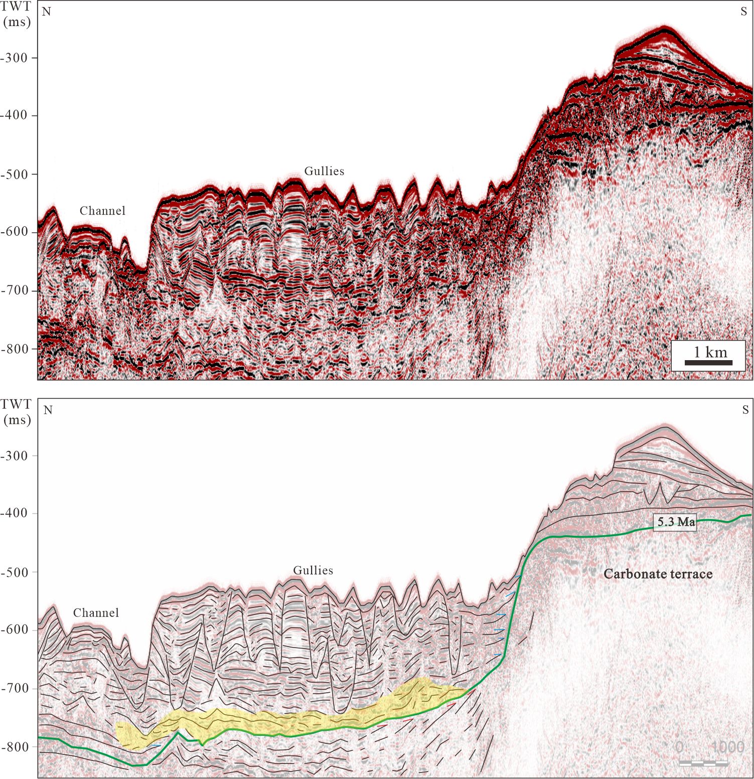
Figure 4. Crossing seismic profile that runs perpendicular to the gully and channel axis, and corresponding stratigraphic interpretation showing the seismic reflection characteristics of gullies and a channel. Gullies are small, linear features with steep sides, while channels are larger and more sinuous, often associated with significant sediment transport. See Figure 1B for the location of the seismic line. In the latter, tics indicate the key stratal terminations: red is truncation and blue is onlap.
4.2 Gullies, channel, and canyon
Gullies were prominent features on the slope, connecting to the top of the platform via a pass (Figures 3A, B). The gullies were 170–600 m wide, with a depth of 3–30 m. Although bathymetric data were lacking for the western upper slope, seismic profiles reveal that the gully flanks exhibit discontinuous reflections of high amplitudes in the upper part and subparallel reflections of low to medium amplitude in the lower part (Figure 4). The gully axes cut into the underlying stratigraphic level, being visible in the seismic data as ‘cut and fill’ structures (Figure 4). Gullies with minor migrations formed after 5.3 Ma. The western slope was intersected by a straight channel that was sufficiently long for detection by bathymetric data (Figure 3B). The channel width ranged from 800 to 1300 m, with a depth of up to 80 m. Multibeam data revealed sediment waves at the termini of the channel (Figure 3B). The channel undercut into slope deposition post-5.3 Ma (Figure 4). Active processes within a large submarine canyon on the southeastern slope enabled the evacuation of the sediments from the MTCs on the carbonate slope. Seismic reflectors predating 5.3 Ma downlapped the canyon seafloor, indicating that the canyon was both filled with sediments deposited prior to 5.3 Ma and had already formed by that time. Long-lived canyons significantly influenced the morphology of long-lived carbonate platforms due to their high potential for gravity-driven processes.
4.3 Drift sedimentation and pelagic deposition
Drift depositions characterized by highly continuous, well-stratified, medium- to low-amplitude reflections were present along the flanks of the eastern drowned carbonate terrace (Figures 5, 6, 7A). The lower part of the drift, referred to as the elongated mounded drift, and showed a more mounded morphology composed of distinct downlapping and overlapping reflections that steepened as the drift prograded upslope (Figure 5). These deposits formed a typical mounded–confined drift that thinned eastward toward the paleo-moat borders (Figure 5). The moat is interpreted as a result of bottom-current scouring, supported by seismic data showing erosional truncation (Figure 5). One major shift in the drift packages occurred at 5.3 Ma that transformed the elongated mounded drift deposition to more widespread sheeted drifts in upper part of the drift (Figure 5). Laterally, sheeted drifts can transition into other drift types, such as elongated mounds in the MTCs zone (Figure 7A). The pelagic sediment layer intervals with turbidite deposition were caused by platform-top sediment input on the western slope (Figure 7B). Sheet deposits and drifts are identified based on their seismic facies and association with current activity. Changes between pelagic and turbiditic deposition were linked to sea-level fluctuaions (Alonso-Garcia et al., 2024). The stratal thickness after 5.3 Ma was relatively greater on the western slope than on the eastern slope (Figure 7).
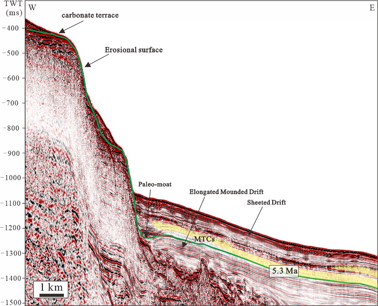
Figure 5. Seismic profile from the eastern carbonate terrace to depositions on the lower slope. The outcropping surface of the terrace formed at 5.3 Ma can be correlated with the shifting boundary between elongated mounded and sheeted drifts. See Figure 1B for the location of the seismic line.
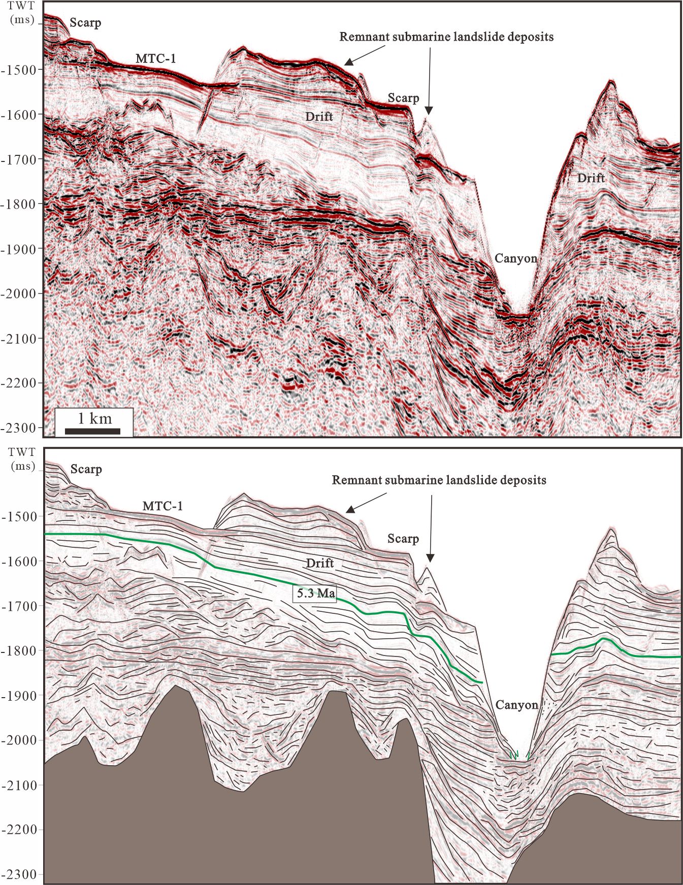
Figure 6. Seismic profile across the southeastern slope failure and the canyon and corresponding stratigraphic interpretation showing that the remnant MTC deposits were preserved within the scarp of MTCs. The canyon was filled with sediments depositing before 5.3 Ma, indicating that the canyon is formed before 5.3 Ma. In the latter, green tics indicate the downlap stratal terminations.
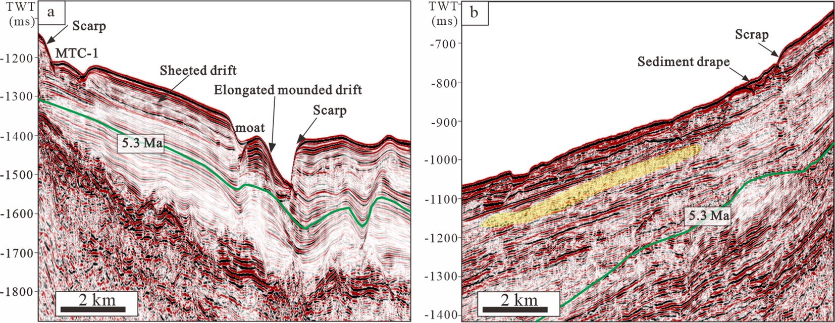
Figure 7. Seismic profile comparison of carbonate slope deposition: (a) across the eastern slope; (b) across the western slope. See Figure 1B for the location of the seismic line.
4.4 Mass-transport complexes
The MTCs described here are closely associated with the windward and leeward slopes, reflecting the influence of monsoonal dynamics on sediment transport. MTCs and remnant deposits are distinguished by their chaotic seismic facies and association with slope instability. At least seven discrete failure scarps related to MTCs were present on the present-day seafloor around the Xuande Platform perimeter (Figures 1B, 3). The headwalls of these MTCs lie at the water depth between 436 and 836 m (Table 1). On the windward slope, the failure scarps of MTC-1 were most visible on the present-day seafloor due to the large height of the headwall scarp and the complete evacuation of internal sediments (Figures 6, 7A). The toe zone of MTC-1 is connected directly to a submarine canyon, as documented by G. Liu et al. (2023). A paleo-scarp was found in the MTC-1 toe near the canyon, indicating that the initial collapse occurred due to the submarine canyon downcutting or incision steepening of the canyon walls. The sediments of the MTC-1 toe generally evolved into turbidity currents or slipped into submarine canyons. Remnant MTC deposits, consisting of a unit of well-stratified medium- to low-amplitude layered reflectors, were observed within the slide scar (Figure 6). MTC-2, located on the northeastern slope, was smaller than MTC-1. With no channel or canyon connected to the toe zone, most of the sediments were preserved within MTC-2, and deformation structures, including compressive folds and thrusts, were generated (Figures 1B, 8). In particular, the long axis of MTC-2 was perpendicular to the direction of the gravity flow, and gravity deposits had a weak ability to move forward in the basin (with a transport distance of 4.6 km). MTC-2 deformed along a prominent high-gradient depositional slope apron that steepened after 5.3 Ma, demonstrating that MTCs on this slope primarily occurred post-5.3 Ma (Figure 8).
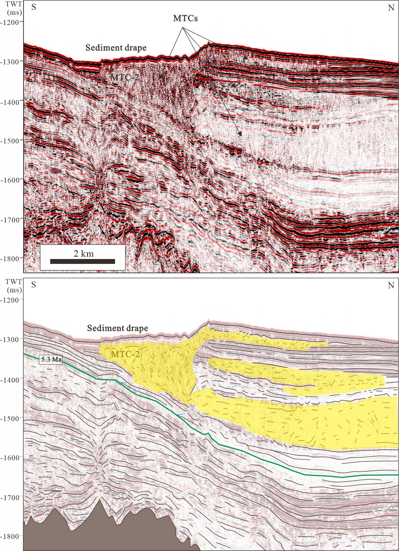
Figure 8. Seismic section across the MTCs on the northeastern slope and corresponding stratigraphic interpretation showing that MTCs mostly occurred after 5.3 Ma. In the latter, tics indicate the key stratal terminations: red indicates truncation, green indicates downlap, and blue indicates onlap.
On the leeward slope, MTC-3 was the largest and was present along the high-gradient depositional slope apron on the northwestern slope (Figures 1B, 3). The northwestern slope was directly connected to the deep basin, which was beneficial for evacuating the distal part of MTC-3. MTC-4, with an evident failure scarp, was observed on the northwestern slope and its toe was also connected to the deep basin. MTC-5, 6, and 7 were present on the western slope, which was far from the northern reef flat. MTC-7, located at the furthest distance from the northern reef flat, was the smallest. Most sediments of these MTCs on the leeward slope were evacuated, except for those of MTC-7 (Figure 9).
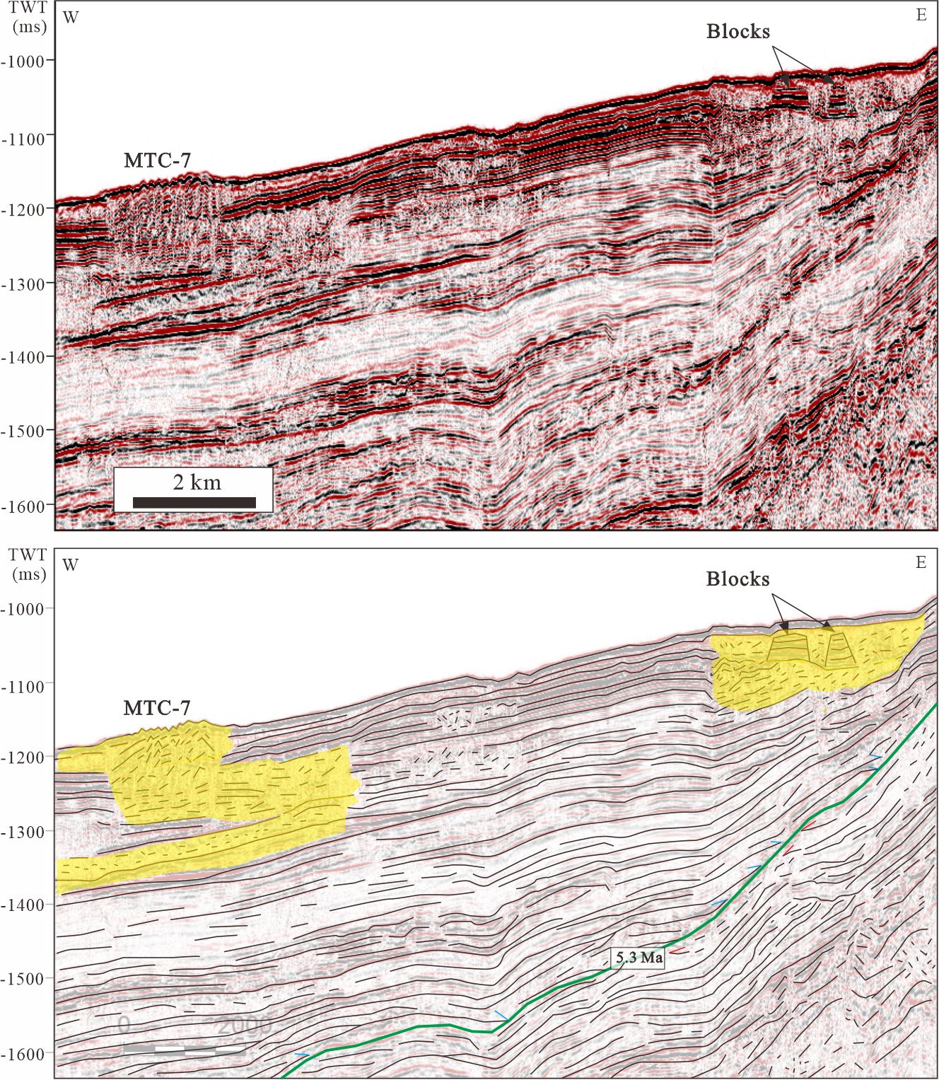
Figure 9. Seismic section across MTCs on the western carbonate slope and corresponding stratigraphic interpretation showing that gravity-flow deposits were interbedded with hemi-pelagic deposits. In the latter, tics indicate the key stratal terminations: red indicates truncation, green indicates downlap, and blue indicates onlap.
5 Discussion
5.1 Influences on sediment export along atoll slope
Our study shows that sediment exported from the platform plays a significant role in peri-platform deposition. Therefore, it is necessary to discuss the parameters controlling sediment export along the atoll slope. The strong export of sediments is highly controlled by monsoon wind-induced surface currents that act along the top of the platform and are responsible for the distribution of sediments and the prevailing off-platform transport to the western slope (Figure 3). Previous studies on platform top sedimentology have been conducted to fully understand how sediment transportation is affected by monsoon-driven currents (Wu et al., 2020; Qin et al., 2022). The difference between the wind strengths of the winter and summer monsoons plays a crucial role in shaping and impacting the Xuande Atoll (Wu et al., 2020; Qin et al., 2022). During the early stages of platform flooding, stronger winter monsoons lead to more significant sediment transport from the windward side to the leeward side; thus, the western leeward slope of Xuande Atoll deposited a thicker slope than the eastern slope (Figure 7). This dominant wind direction causing increased sediment supply and sedimentation on the leeward slope has been commonly found in other carbonate platforms (Wunsch et al., 2017; Counts et al., 2018).
The morphological features along the platform margin also influence the rate and sediment type of off-platform transport to the surrounding slope. These reef rims and islands were interpreted as obstacles that prevented the off-bank transport of sediments from the platform interior to its slope (Figures 1B, 3). Reef rims and islands are also regarded as obstacles that prevent aragonitic mud-sized particles from being steadily exported by daily tides and episodic cascading density flows in the GBB (Principaud et al., 2018). Without a continuous reef rim on the western margin, huge amounts of sediment in the platform interior were transported toward the western slope (Figure 3). Sediments from the platform interior were exported and transported through the gullies until they reached the lower slope (Figures 3, 4). With a continuous reef rim on the northeastern and southeastern margins, most of the sediments transported to the northeastern and southeastern slopes were dominated by coarse and heavy materials generated from reef flats. The difference in sediment export between platform margins with and without a barrier was marked by the presence or absence of gullies on the slope. The gullies could only be found on the platform slope that connected to the platform margin without a reef rim (Figures 1B, 3, 4), indicating that sediment export was influenced by morphology along the platform margin.
Short-term sea level fluctuations are important factors controlling platform-derived sedimentation on slopes (Reolid et al., 2016; Wunsch et al., 2018; Sultan et al., 2023; Alonso-Garcia et al., 2024). The alternation of the cutting and filling of the gullies mostly occurred after 5.3 Ma (Figure 4), indicating that the Pliocene–Pleistocene high-amplitude sea-level changes played a significant role in sediment export along the atoll slope. During sea level rise and highstand, the sediments exported from the platform were funneled by these gullies. These gullies were subsequently filled and became inactive during sea-level lowstands. Similar sedimentary processes in gullies controlled by sea level changes have also been found on the leeward slope of the GBB (Wunsch et al., 2017).
5.2 Controls on slope deposition and geomorphology
The parameters controlling sediment export along the atoll slope also influenced slope depositional architecture. The direction and intensity of dominant monsoon winds have long been known to affect facies distribution and sediment transportation on carbonate platforms (Betzler and Eberli, 2019; Wu et al., 2020; Clift et al., 2022; Alonso-Garcia et al., 2024). In the Xuande Atoll, the top of the platform showed some degree of wind-related asymmetry that extends to the slope. The wind-related asymmetry of slope deposition caused by off-platform sediment transport has also been documented by Counts et al. (2018). Leeward platform margins with no barriers between the platform top and slope break promote continuous deposition and sediment transfer, generating a gentle slope that is generally dissected by gullies. A windward platform margin with a mostly continuous fringing reef prevents the continual transfer of large amounts of sediment from the inner platform to the slope, leading to an oversteepened and sediment-starved windward slope that usually lacks a gully system. Only coarse and heavy materials are intermittently transported to the windward slope.
The emplacement of the MTCs is closely related to the type of sediment transported from the top of the platform. Reijmer et al. (2015) reported that two types of gravity deposits, calciturbidites and calcidebrites, were found around the Bahama carbonate platform. In their study, calcidebrites, composed of coarse and heavy materials, originated from the platform edge, whereas calciturbidites, composed of fine and light materials, originated from the platform interior. In our study, MTC-1 and MTC-2 on the windward slope were characterized by remnant deposits and a limited transport distance, respectively, demonstrating that these MTCs were likely influenced by calcidebrites originating from the platform edge and deposited in a more proximal position. Drilling cores around modern and ancient ICPs show that calcidebrites occur at the proximal slope (Reijmer et al., 2015; Counts et al., 2021), which agrees with our view that calcidebrites play a significant role in windward slope geomorphology. Instead, the frequent occurrence of gullies and channels on the leeward slope suggests that calciturbidites were dominant in sculpturing the slope morphology. The upslope-facing sediment waves at the termini of the channel were also evidence that the leeward slope geomorphology was closely linked to calciturbidites. The MTCs were mostly related to calciturbidites that resulted from frequent headscraps. Furthermore, most MTCs had a long transport distance and a strong ability to move forward in the basin, suggesting that the MTCs on the leeward slope were composed of fine and light material from the platform interior.
In addition to the control of platform-top sediment export, the eastern toes of slopes of the Xuande Atoll were affected by strong currents in that a number of contourite drifts and moats occurred on the present-day seafloor (Figures 5, 6, 7A). The external shape of the drift sedimentation changed from mounded to sheeted geometry upward at 5.3 Ma, demonstrating a gradual decrease in energy in the bottom currents. A previous study has shown that dominated bottom currents in the SCS shifted from the monsoonal wind-driven currents and North Pacific waters to the modern circulation system at 6.5–5.3 Ma (S. Liu et al., 2022). The results of this study support the view that the shift in the dominant bottom currents causing decreasing energy led to a change in the drift sedimentation style. The transformation of sheeted drifts into other drift types within the MTCs was driven by changes in the bottom current energy. Geomorphology is also considered the main driving force of the current regime and drift-style formation in the Maldives (Lüdmann et al., 2022).
In summary, the distinct variations in geomorphology and deposition between the leeward and windward carbonate platform slopes are thought to be controlled by sediment export from the platform top and currents. A summary study of modern Bahamian carbonate slopes also proposed that the characteristics of Bahamian slope deposition were controlled by facies on adjacent shallow-water platforms and shallow- and deep-water currents (Fauquembergue et al., 2024). Our study provides a classic example in which the wind-related asymmetric facies distribution on a platform plays a significant role in shaping the windward and leeward slope geomorphology.
5.3 Summary and facies model
A previous study showed that the platform top of the Xuande Atoll is characterized by a wind-related asymmetric facies distribution (Wu et al., 2020). Our study proposes that heterogeneities in carbonate slope sedimentation depend on the input of various sediment types caused by the asymmetric facies distribution on the platform top. The windward slope is characterized by short-distance transported MTCs and lacks gullies or channels. A reasonable explanation is that the windward slope is mostly connected to the platform margin with elevated reef flats, and the slope deposits are mainly composed of coarse and heavy materials with a poor ability to move forward in the basin. Instead, the leeward slope received mostly fine and light carbonate sediments transported by wind-driven currents from the interior platform through the platform margin without fringing reef flats. Therefore, the MTCs present on the modern seafloor stretch toward the direction of sediment transportation and the headscraps of MTCs seem easier to evacuate on the leeward slope, supporting the view that fine and light sediments are transported to the leeward slope from the interior platform. The formation of channels and gullies on the leeward slope also suggests that the gravity deposits are dominated by calciturbidites.
The sedimentary model shows a composite sketch that combines many of the geomorphological and depositional features observed across the platforms (Figure 10). Past models mostly stress the heterogeneities in the geometry of slope deposition (Schlager and Ginsburg, 1981; Schlager and Camber, 1986; Playton et al., 2010), having generally not focused on the difference and comparison between windward and leeward slope deposition. However, wind-related asymmetric facies distributions on carbonate platforms commonly extend to carbonate slopes. The established facies model revealed that distinct geomorphologies, depositional elements, and sedimentary processes occurred on the windward and leeward slopes (Figure 10). Our model integrates the different sedimentary processes that lead to the described bedforms and structures on both slopes. By focusing on both sides, this study highlights the contrasting mechanisms of sediment accumulation and erosion, offering new insights into the spatial variability of carbonate platform development.

Figure 10. Depositional models of carbonate slopes under monsoonal and current influences: (a) Windward slope – Exhibits gravity-driven export of coarse sediments (purple arrows) from reef flats, with bottom current modification and pronounced slope instability; (b) Leeward slope – Dominated by wind-driven transport of fine sediments (brown arrows) along depositional surfaces, with attenuated slope morphology development.
5.4 Implications
This study stresses the role of the platform top facies distribution and sediment export in platform slope deposition. These results suggest that heterogeneities in slope sedimentation are mainly related to wind-driven asymmetric deposition on the platform top and the input of various sediment types from the platform top, improving our understanding of carbonate slope sedimentation. Although the carbonate slope deposition in this study is relatively recent in origin, its distribution and characteristics may be used as an analog for periplatform sedimentation elsewhere. The relationship of wind-related asymmetric deposition between the platform top and slope can be applied not only to Cenozoic platforms, but also to Mesozoic and Paleozoic carbonate platforms, where information about paleoclimate and paleoceanography is usually lacking. Our study proposes that slope deposition adjacent to the windward platform edge probably includes coarse sediments with more potential as conventional hydrocarbon reservoirs than peri-platform muds. Therefore, our findings on Xuande Atoll provide a framework for understanding carbonate slope deposition in other monsoonal settings, such as the Indo-Pacific. The observed asymmetry in slope morphology and sedimentation patterns has important implications for predicting reservoir properties and hydrocarbon distribution in analogous ancient carbonate platforms.
6 Conclusions
This study provides a comprehensive analysis of the heterogeneities in carbonate slope sedimentation along a modern isolated carbonate platform, influenced by sediment export from the platform top and prevailing currents. Our research introduces a novel sedimentary model that delineates the distinct depositional processes and facies distributions on both the leeward and windward slopes of the platform. A key innovation of this study lies in demonstrating how wind-related asymmetric facies distribution at the top of the platform extends to the carbonate slope. On the windward slope, we identified that MTCs exhibits limited transport distances, with numerous remnant blocks preserved, a feature directly linked to the input of coarse-grained and heavy sediments from reef flats. Furthermore, our findings reveal that carbonate sediments are ultimately deposited on the lower slope or proximal basin in the form of calcidebrites interbedded with hemipelagic foraminiferal muds, highlighting the interplay between gravity flows and contour currents in shaping mass transport deposits and drift sedimentation. On the leeward slope, we discovered that fine and light carbonate sediments from the interior platform were transported by wind-driven currents, leading to the formation of calciturbidites, gullies, channels, and MTCs with long-distance transportation. This process underscores the role of wind-driven currents in undercutting the slope and generating complex geomorphic features. Our study thus advances the understanding of carbonate slope deposition by elucidating the combined effects of multiple sedimentation processes and depositional elements, resulting in spatially heterogeneous sedimentation patterns on both the platform top and slope. These findings provide critical insights into variability of properties in ancient carbonate platforms, offering a refined framework for interpreting their depositional histories. The innovative sedimentary model presented here not only enhances the current knowledge of carbonate platform dynamics but also serves as a valuable tool for future research and exploration in analogous settings.
Data availability statement
The original contributions presented in the study are included in the article/supplementary material. Further inquiries can be directed to the corresponding author.
Author contributions
GL: Conceptualization, Funding acquisition, Investigation, Project administration, Writing – original draft. WC: Methodology, Validation, Writing – original draft, Writing – review & editing, Conceptualization, Funding acquisition. WS: Project administration, Supervision, Validation, Writing – review & editing. JC: Data curation, Investigation, Methodology, Validation, Writing – review & editing. YS: Data curation, Investigation, Methodology, Writing – review & editing. FZ: Data curation, Investigation, Methodology, Writing – review & editing. XL: Investigation, Methodology, Writing – review & editing.
Funding
The author(s) declare that financial support was received for the research and/or publication of this article. The authors thank the Marine Geological Survey Institute of Hainan Province and Guangzhou Marine Geological Survey for providing bathymetric and seismic data. This research was supported by the following funding sources: Hainan Provincial Joint Project of Sanya Yazhou Bay Science and Technology City (Grant No. 2021JJLH0047): Supported the analysis of geological and geophysical data. National Natural Science Foundation of China (Grant No. 42406081): Funded the theoretical research of the study. Hainan Provincial Natural Science Foundation of China (Grant No. 422QN353): Provided financial support for fieldwork and sample collection. The Scholarship Fund by China Scholarship Council and Postdoctoral Funded Project in Hainan Province: Supported the postdoctoral researcher’s contribution to data interpretation and manuscript preparation.
Acknowledgments
The authors thank the Marine Geological Survey Institute of Hainan Province and Guangzhou Marine Geological Survey for providing bathymetric and seismic data.
Conflict of interest
The authors declare that the research was conducted in the absence of any commercial or financial relationships that could be construed as a potential conflict of interest.
Generative AI statement
The author(s) declare that no Generative AI was used in the creation of this manuscript.
Publisher’s note
All claims expressed in this article are solely those of the authors and do not necessarily represent those of their affiliated organizations, or those of the publisher, the editors and the reviewers. Any product that may be evaluated in this article, or claim that may be made by its manufacturer, is not guaranteed or endorsed by the publisher.
References
Alonso-Garcia M., Reolid J., Jimenez-Espejo F. J., Bialik O. M., Alvarez Zarikian C. A., Laya J. C., et al. (2024). Sea-level and monsoonal control on the Maldives carbonate platform (Indian Ocean) over the last 1.3 million years. Climate Past 20, 547–571. doi: 10.5194/cp-20-547-2024
Betzler C., Eberli G. P. (2019). Miocene start of modern carbonate platforms. Geology 47, 771–775. doi: 10.1130/G45994.1
Betzler C., Lindhorst S., Eberli G. P., Lüdmann T., Möbius J., Ludwig J., et al. (2014). Periplatform drift: The combined result of contour current and off-bank transport along carbonate platforms. Geology 42, 871–874. doi: 10.1130/g35900.1
Chabaud L., Ducassou E., Tournadour E., Mulder T., Reijmer J. J. G., Conesa G., et al. (2016). Sedimentary processes determining the modern carbonate periplatform drift of Little Bahama Bank. Marine Geol. 378, 213–229. doi: 10.1016/j.margeo.2015.11.006
Chen G., Wang D., Dong C., Zu T., Xue H., Shu Y., et al. (2015). Observed deep energetic eddies by seamount wake. Sci. Rep. 5, 17416. doi: 10.1038/srep17416
Chen W., Huang X., Wu S., Liu G., Wei H., Wu J. (2021). Facies character and geochemical signature in the late Quaternary meteoric diagenetic carbonate succession at the Xisha Islands, South China Sea. Acta Oceanologica Sin. 40, 94–111. doi: 10.1007/s13131-021-1713-6
Cheng X., Huang B., Jian Z., Zhao Q., Tian J., Li J. (2005). Foraminiferal isotopic evidence for monsoonal activity in the South China Sea: a present-LGM comparison. Marine Micropaleontol. 54, 125–139. doi: 10.1016/j.marmicro.2004.09.007
Clift P., Betzler C., Christensen B., Clemens S., Eberli G., France-Lanord C., et al. (2022). A synthesis of monsoon exploration in the Asian marginal seas. Sci. Drilling 10, 1–29. doi: 10.5194/sd-10-1-2022
Collins J., Narr W., Harris P., Playton T., Jenkins S., Tankersley T., et al. (2014). “Lithofacies, Depositional Environments, Burial Diagenesis, and Dynamic Field Behavior in a Carboniferous Slope Reservoir, Tengiz Field (Republic of Kazakhstan), and Comparison with Outcrop Analogs,” in Deposits, Architecture, and Controls of Carbonate Margin, Slope, and Basinal Settings (Tulsa, Oklahoma, USA: SEPM (Society for Sedimentary Geology)), 50–83.
Counts J. W., Jorry S. J., Leroux E., Miramontes E., Jouet G. (2018). Sedimentation adjacent to atolls and volcano-cored carbonate platforms in the Mozambique Channel (SW Indian Ocean). Marine Geol. 404, 41–59. doi: 10.1016/j.margeo.2018.07.003
Counts J. W., Jorry S. J., Vazquez-Riveiros N., Amy L. A., Dennielou E., Jouet G. (2021). Sedimentology and distribution of late quaternary calciturbidites and calcidebrites in the Mozambique Channel (Southwest Indian Ocean). Facies 67, 17–39. doi: 10.1007/s10347-021-00624-1
Droxler A. W., Jorry S. J. (2021). The origin of modern atolls: challenging darwin’s deeply ingrained theory. Ann. Rev. Mar Sci. 13, 537–573. doi: 10.1146/annurev-marine-122414-034137
Fang G., Wang Y., Wei Z., Fang Y., Qiao F., Hu X. (2009). Interocean circulation and heat and freshwater budgets of the South China Sea based on a numerical model. Dynamics Atmospheres Oceans 47, 55–72. doi: 10.1016/j.dynatmoce.2008.09.003
Fauquembergue K., Mulder T., Reijmer J., Hanquiez V., Betzler C., Ducassou E., et al. (2024). Sedimentology of modern bahamian carbonate slopes: summary and update. Geochemistry Geophys. Geosystems 25, e2023GC011077. doi: 10.1029/2023gc011077
Guo Z. T., Ruddiman W. F., Hao Q. Z., Wu H. B., Qiao Y. S., Zhu R. X., et al. (2002). Onset of Asian desertification by 22 Myr ago inferred from loess deposits in China. Nature 416, 159–163. doi: 10.1038/416159a
Haq B. U., Hardenbol J., Vail P. R. (1987). Chronology of Fluctuating Sea Levels since the Triassic. Science 235 (4793), 1156–1167. doi: 10.1126/science.235.4793.1156
Hu J., Kawamura H., Hong H., Qi Y. (2000). A review on the currents in the south China sea: seasonal circulation, south China sea warm current and kuroshio intrusion. J. Oceanogr. 56, 607–624. doi: 10.1023/A:1011117531252
Jiang W., Yu K., Fan T., Xu S., Wang R., Zhang Y., et al. (2019). Coral reef carbonate record of the Pliocene-Pleistocene climate transition from an atoll in the South China Sea. Marine Geol. 411, 88–97. doi: 10.1016/j.margeo.2019.02.006
Jorry S. J., Camoin G. F., Jouet G., Roy P. L., Vella C., Courgeon S., et al. (2016). Modern sediments and Pleistocene reefs from isolated carbonate platforms (Iles Eparses, SW Indian Ocean): A preliminary study. Acta Oecologica 72, 129–143. doi: 10.1016/j.actao.2015.10.014
Liu T., Ding Z., Rutter N. (1999). Comparison of Milankovitch periods between continental loess and deep sea records over the last 2.5 Ma. Quaternary Sci. Rev. 18, 1205–1212. doi: 10.1016/S0277-3791(98)00110-3
Liu S., Liang Z., Zhang B., Su H., Lei Z., Su M. (2022). Carbonate contourite drifts in the southwest South China Sea: Sedimentary, paleoceanographic and economic implications. Front. Marine Sci. 9, 946231. doi: 10.3389/fmars.2022.946231
Liu J., Liu K., Salles T., Li C. (2022). Factors controlling carbonate slope failures: Insight from stratigraphic forward modelling. Earth-Science Rev. 232. doi: 10.1016/j.earscirev.2022.104108
Liu G., Wang D., Chen W., Wang W., Betzler C., Han X. (2023). Submarine landslides on a carbonate platform slope changing transport pathways of deepwater gravity flows: Insights from the Xisha Islands, South China Sea. Geomorphology 437, 108813. doi: 10.1016/j.geomorph.2023.108813
Liu Y., Wu S., Li X., Chen W., Han X., Yang C., et al. (2023). Seismic stratigraphy and development of a modern isolated carbonate platform (Xuande Atoll) in the South China Sea. Front. Earth Sci. 10. doi: 10.3389/feart.2022.1042371
Lüdmann T., Betzler C., Lindhorst S. (2022). The Maldives, a key location of carbonate drifts. Marine Geol. 450, as106838. doi: 10.1016/j.margeo.2022.106838
Matter J. M., Kelemen P. B. (2009). Permanent storage of carbon dioxide in geological reservoirs by mineral carbonation. Nat. Geosci. 2, 837–841. doi: 10.1038/ngeo683
McAdoo B. G., Pratson L. F., Orange D. L. (2000). Submarine landslide geomorphology, US continental slope. Marine Geol. 169, 103–136. doi: 10.1016/S0025-3227(00)00050-5
Miller K. G., Browning J. V., Schmelz W. J., Kopp R. E., Mountain G. S., Wright J. D. (2020). Cenozoic sea-level and cryospheric evolution from deep-sea geochemical and continental margin records. Science Advances 6 (20), eaaz1346. doi: 10.1126/sciadv.aaz1346
Mulder T., Ducassou E., Hanquiez V., Principaud M., Fauquembergue K., Tournadour E., et al. (2019). Contour current imprints and contourite drifts in the Bahamian archipelago. Sedimentology 66, 1192–1221. doi: 10.1111/sed.12587
Peter A., Yang D., Eshiet K. I.-I. I., Sheng Y. (2022). A review of the studies on CO2–brine–rock interaction in geological storage process. Geosciences 12, 168. doi: 10.3390/geosciences12040168
Petrovic A., Reijmer J. J. G., Alsaihati S. H. M., Nommensen D., Vahrenkamp V. (2023). Sediment dynamics and geomorphology of a submarine carbonate platform canyon system situated in an arid climate setting. Sedimentology 70, 2241–2271. doi: 10.1111/sed.13120
Peyrotty G., Rigaud S., Kemkin I., Martini R. (2020). Sedimentology and biostratigraphy of upper Triassic atoll-type carbonates from the Dalnegorsk area, Taukha terrane, far East Russia. Global Planetary Change 184, 103072. doi: 10.1016/j.gloplacha.2019.103072
Playton T., Janson X., Kerans C. (2010). “Carbonate Slopes,” in Facies Models, vol. 4 . Ed. Noel James R. D. (St. John's, Newfoundland and Labrador, Canada: Geological Association of Canada), 449–476.
Principaud M., Mulder T., Gillet H., Borgomano J. (2015). Large-scale carbonate submarine mass-wasting along the northwestern slope of the Great Bahama Bank (Bahamas): Morphology, architecture, and mechanisms. Sedimentary Geol. 317, 27–42. doi: 10.1016/j.sedgeo.2014.10.008
Principaud M., Mulder T., Hanquiez V., Ducassou E., Eberli G. P., Chabaud L., et al. (2018). Recent morphology and sedimentary processes along the western slope of Great Bahama Bank (Bahamas). Sedimentology 65, 2088–2116. doi: 10.1111/sed.12458
Purdy E. G., Gischler E. (2005). The transient nature of the empty bucket model of reef sedimentation. Sedimentary Geol. 175, 35–47. doi: 10.1016/j.sedgeo.2005.01.007
Qiang X., Xiao J. G., Wang D. X., Yu Y. Q. (2013). Analysis of deep-layer and bottom circulations in the South China Sea based on eight quasi-global ocean model outputs. Chin. Sci. Bull. 58, 4000–4011. doi: 10.1007/s11434-013-5791-5
Qin Y., Wu S., Betzler C. (2022). Backstepping patterns of an isolated carbonate platform in the northern South China Sea and its implication for paleoceanography and paleoclimate. Marine Petroleum Geol. 146, 105927. doi: 10.1016/j.marpetgeo.2022.105927
Recouvreur A., Fabregas N., Mulder T., Hanquiez V., Fauquembergue K., Tournadour E., et al. (2020). Geomorphology of a modern carbonate slope system and associated sedimentary processes: Example of the giant Great Abaco Canyon, Bahamas. Sedimentology 68, 266–293. doi: 10.1111/sed.12777
Reijmer J. J. G., Bauch T., Zechel S., Reuning L., Otto R., Swart P. K., et al. (2009). A Re-Evaluation of Facies on Great Bahama Bank I: New Facies Maps of Western Great Bahama Bank. In Perspectives in Carbonate Geology (eds Swart P. K., Eberli G. P., McKenzie J. A., Jarvis I., Stevens T.). doi: 10.1002/9781444312065.ch3
Reijmer J. J. G., Palmieri P., Groen R., Floquet M. (2015). Calciturbidites and calcidebrites: Sea-level variations or tectonic processes? Sedimentary Geol. 317, 53–70. doi: 10.1016/j.sedgeo.2014.10.013
Reolid J., Betzler C., Braga J. C. (2016). Amplitude of late Miocene sea-level fluctuations from karst development in reef-slope deposits (SE Spain). Sedimentary Geol. 345, 145–153. doi: 10.1016/j.sedgeo.2016.09.009
Schlager W., Camber O. (1986). Submarine slope angles, drowning unconformities, and self-erosion of limestone escarpments. Geology 14, 762–765. doi: 10.1130/0091-7613(1986)14<762:SSADUA>2.0.CO;2
Schlager W., Ginsburg R. N. (1981). Bahama carbonate platforms - The deep and the past. Marine Geol. 44, 1–24. doi: 10.1016/0025-3227(81)90111-0
Shao L., Cui Y., Qiao P., Zhang D., Liu X., Zhang C. (2017). Sea-level changes and carbonate platform evolution of the Xisha Islands (South China Sea) since the Early Miocene. Palaeogeogr. Palaeoclimatol. Palaeoecol. 485, 504–516. doi: 10.1016/j.palaeo.2017.07.006
Shao L., Li X., Geng J., Pang X., Lei Y., Qiao P., et al. (2007). Deep water bottom current deposition in the northern South China Sea. Science in China Series D: Earth Sciences 50 (7), 1060–1066. doi: 10.1007/s11430-007-0015-y
Shu Y., Xue H., Wang D., Chai F., Xie Q., Yao J., et al. (2014). Meridional overturning circulation in the South China Sea envisioned from the high-resolution global reanalysis data GLBa0.08. J. Geophysical Research-Oceans 119, 3012–3028. doi: 10.1002/2013jc009583
Siqueira T. A., Iglesias R. S., Ketzer J. M. (2017). Carbon dioxide injection in carbonate reservoirs – a review of CO2-water-rock interaction studies. Greenhouse Gases: Sci. Technol. 7, 802–816. doi: 10.1002/ghg.1693
Sultan N., Jouet G., Riboulot V., Terzariol M., Garziglia S., Cattaneo A., et al. (2023). Sea-level fluctuations control the distribution of highly liquefaction-prone layers on volcanic-carbonate slopes. Geology 51, 402–407. doi: 10.1130/g50785.1
Sun Q., Xie X., Piper D. J. W., Wu J., Wu S. (2017). Three dimensional seismic anatomy of multi-stage mass transport deposits in the Pearl River Mouth Basin, northern South China Sea: Their ages and kinematics. Marine Geol. 393, 93–108. doi: 10.1016/j.margeo.2017.05.005
Wan S., Li A., Clift P. D., Stuut J.-B. W. (2007). Development of the East Asian monsoon: Mineralogical and sedimentologic records in the northern South China Sea since 20 Ma. Palaeogeogr. Palaeoclimatol. Palaeoecol. 254, 561–582. doi: 10.1016/j.palaeo.2007.07.009
Wang L., Sarnthein M., Erlenkeuser H., Grimalt J., Grootes P., Heilig S., et al. (1999). East Asian monsoon climate during the Late Pleistocene: high-resolution sediment records from the South China Sea. Marine Geol. 156, 245–284. doi: 10.1016/S0025-3227(98)00182-0
Wang Z., Shi Z., Zhang D., Huang K., You L., Duan X., et al. (2015). Microscopic features and genesis for miocene to pliocene dolomite in well xike-1,Xisha islands. Earth Sci. 40, 633–644. doi: 10.3799/dqkx.2015.050
Wang G. H., Xie S. P., Qu T. D., Huang R. X. (2011). Deep south China sea circulation. Geophysical Res. Lett. 38, 6. doi: 10.1029/2010gl046626
Wei H., Liu G., Han X., Zhao Y., Wu J., Yang J., et al. (2023). Coral-based rare earth element proxy for hydrothermal fluid on the Yongxing Island, South China Sea. Ore Geol. Rev. 162, 105678. doi: 10.1016/j.oregeorev.2023.105678
Wolfgang Schlager J. J. G. R. (1994). Highstand shedding of carbonate platforms. SEPM J. Sedimentary Res. 64B, 270–281. doi: 10.1306/d4267faa-2b26-11d7-8648000102c1865d
Wu N. (2022). Diagenetic priming of submarine landslides in ooze-rich substrates. Geology 51, 85–90. doi: 10.1130/G50458.1
Wu S., Chen W., Huang X., Liu G., Li X., Betzler C. (2020). Facies model on the modern isolated carbonate platform in the Xisha Archipelago, South China Sea. Marine Geol. 425, 106203. doi: 10.1016/j.margeo.2020.106203
Wu F., Xie X., Betzler C., Zhu W., Zhu Y., Guo L., et al. (2019). The impact of eustatic sea-level fluctuations, temperature variations and nutrient-level changes since the Pliocene on tropical carbonate platform (Xisha Islands, South China Sea). Palaeogeogr. Palaeoclimatol. Palaeoecol. 514, 373–385. doi: 10.1016/j.palaeo.2018.10.013
Wunsch M., Betzler C., Eberli G. P., Lindhorst S., Lüdmann T., Reijmer J. J. G. (2018). Sedimentary dynamics and high-frequency sequence stratigraphy of the southwestern slope of Great Bahama Bank. Sedimentary Geol. 363, 96–117. doi: 10.1016/j.sedgeo.2017.10.013
Wunsch M., Betzler C., Lindhorst S., Lüdmann T., Eberli G. P., Della Porta G. (2017). Sedimentary dynamics along carbonate slopes (Bahamas archipelago). Sedimentology 64, 631–657. doi: 10.1111/sed.12317
Yu K., Alves T. M., Li W., Li S., Li J., Zhao F., et al. (2022). The role of bottom currents on the morphological development around a drowned carbonate platform, NW south China sea. J. Ocean Univ. China 21, 801–812. doi: 10.1007/s11802-022-5020-4
Zhao Q., Wu S., Xu H., Sun Q., Wang B., Sun Y., et al. (2011). Sedimentary facies and evolution of aeolianites on Shidao Island, Xisha Islands. Chin. J. Oceanol. Limnol. 29, 398–413. doi: 10.1007/s00343-011-0018-6
Keywords: South China Sea, carbonate platform, carbonate slopes, atoll, geomorphology
Citation: Liu G, Chen W, Wu S, Chen J, Sun Y, Zeng F and Li X (2025) The dominant control of wind-driven asymmetry and sediment export on carbonate slope around a semi-enclosed atoll in the South China Sea. Front. Mar. Sci. 12:1563511. doi: 10.3389/fmars.2025.1563511
Received: 20 January 2025; Accepted: 31 March 2025;
Published: 17 April 2025.
Edited by:
Jiaopeng Sun, Northwest University, ChinaCopyright © 2025 Liu, Chen, Wu, Chen, Sun, Zeng and Li. This is an open-access article distributed under the terms of the Creative Commons Attribution License (CC BY). The use, distribution or reproduction in other forums is permitted, provided the original author(s) and the copyright owner(s) are credited and that the original publication in this journal is cited, in accordance with accepted academic practice. No use, distribution or reproduction is permitted which does not comply with these terms.
*Correspondence: Wanli Chen, Y2hlbndsQGlkc3NlLmFjLmNu