 John Falkingham
- International Ice Charting Working Group, Ottawa, ON, Canada
Since 1999, the International Ice Charting Working Group (IICWG) has successfully worked as a forum for the operational ice services and helped them to better meet the needs of their national and international maritime clients through coordination and cooperation in data sharing, standards, training, product development, and research activities. The annual meeting has proven to be a valuable opportunity for the national ice services to meet, along with their partners and clients, to share information about new research developments, implementation successes and failures, and advances in ice information products and services. This paper presents a brief overview of the first twenty-five years of the IICWG, including its raison d’être, the history of its formation, its organization, and its accomplishments.
1 Introduction
This paper was written on the 25th anniversary of the first meeting of the International Ice Charting Working Group (IICWG). Its purpose is to document its history and celebrate its accomplishments.
Over 25 years, the IICWG has been successful at developing a collegial working relationship amongst the world’s ice information services – those governmental organizations that provide information about sea ice, lake ice and icebergs for the safety of marine operations. Several of the original founders have passed away. Many others have retired or moved on to other endeavours and been replaced by their successors. This infusion of new talents and ideas is critical to continuing success but comes with a loss of historical context and appreciation for the founding principles of the IICWG. The intention here is to help preserve that organizational memory as a foundation for the future.
2 What is the IICWG?
2.1 Mission
The IICWG was formed as an ad-hoc working group of northern hemisphere national ice services, primarily for the purpose of exchanging information and ideas to help one another better serve their clients. The preamble to the Terms of Reference (IICWG, 2016), adopted at the very first meeting in 1999, clearly and succinctly defines why the IICWG exists and what it does:
“Recognizing the ongoing interest of the nations influenced by ice covered seas in the use and protection of these seas; and further recognizing the value and economics of cooperative activities in operational ice services supporting maritime navigation; the ice charting nations of the world hereby form the International Ice Charting Working Group.
“The International Ice Charting Working Group provides a forum for coordination of ice matters, including icebergs, acts as an advisory body for the relevant international sea organizations and programs, in particular, WMO/IOC JCOMM, CLiC, GCOS and IHO, and offers non-binding recommendations to senior management as appropriate …”.
Following the preamble, the Terms of Reference outline the activities that are of interest to the IICWG:
● Data and Product Exchange.
● Terminology, Data and Mapping Standards.
● Operations and Customer Support.
● Training.
● Technology for Analysis and Forecasting.
● Applied Science, Research and Development.
Of central importance in defining the IICWG’s mission is the notion that it is concerned primarily with “operational ice services supporting maritime navigation”. While research activities and climatological investigations are critical components of an ice service, they are not the focus of the IICWG. The IICWG founders felt that these peripheral aspects were adequately addressed in other fora. It was in the coordination and development of operational services that the IICWG was filling a gap and where it should focus its attention. This intention is instilled throughout the Terms of Reference.
2.2 Vision and strategic goals
By 2017, the IICWG felt that a rejuvenation was needed. Many original issues that provided focus had been resolved but changes in the environment, technology, and relationships with other organizations were demanding more and more energy. Under the leadership of co-chairs Diane Campbell, Marianne Thyrring, and Tom Cuff, a concise statement of the IICWG’s vision and strategic goals was adopted at the Helsinki meeting in 2018. This was further developed, at the 25th meeting in 2024, into the Vision, Mission, Values and Strategic Goals (IICWG, 2024) attached at Appendix A.
2.3 Members/participants
Throughout its history, the IICWG has been an open group without a sense of requirement for formal membership. Representatives of the national ice services form the core of participation in the annual meetings and undertake the bulk of its work. However, private ice services have also taken an active role in the Working Group. Space agencies, as the suppliers of ice monitoring data, are regular participants in a two-way dialogue with the ice services – providing information about earth observation programs and accepting requirements for ice monitoring. Client groups take part in the IICWG to inform the ice services of their information needs and to influence the services’ activities and initiatives accordingly. Research communities join in the Group to share their findings and learn of operational requirements that can help direct their research towards useful ends.
2.4 Clients
From its beginning, the IICWG has maintained a strong focus on the clients of the ice services. Marine transportation operators and regulators, including national maritime administrations and icebreaker operators, shipping companies, Coast Guards, Navies, offshore oil and gas operations, fishing fleets and field research campaigns, are the primary customers of the ice services that participate in the IICWG. Meteorological organizations, policy-makers, marine engineers, and residents in ice-affected regions represent more diverse client sectors. The IICWG tries to understand the needs of their clients by offering, at the yearly meetings, a forum for them to interact directly with the ice services. The Group has shared many instances of best practices in serving clients and has undertaken actions to improve the availability and usability of ice information globally.
2.5 IICWG relationship with legal authorities
As an ad-hoc working group, the IICWG is independent and free to establish its own working rules, set its own agenda and act in areas its participants deem worthwhile. Individuals and organizations participate at their own expense. The IICWG has no budget of its own and can reach its objectives only when its individual participants are willing and able to undertake the necessary work. This “ad-hoc-ness” has both good and bad aspects. On the positive side, it has allowed the Group to work quickly to address concerns without the burden of overhead imposed by a bureaucratic organizational structure. However, it also presents difficulties for some participants to get support for IICWG initiatives within their parent (national) organizations and has the disadvantage of uncertain support for on-going activities. To respond to these downsides, the IICWG has positioned itself as an advisory body to the established, legal, international authorities.
For the first two decades, the primary connection was with the Joint WMO/IOC Technical Commission for Oceanography and Marine Meteorology (JCOMM) Expert Team on Sea Ice (ETSI) (JCOMM, 2023). JCOMM was a joint commission of the Intergovernmental Oceanographic Commission (IOC) and the World Meteorological Organization (WMO) and enjoyed the support of both of those esteemed bodies. However, as a result, the ETSI was encumbered by IOC/WMO rules, finances, membership limitations and infrequent meetings. The IICWG is not so encumbered and therefore was well positioned to react quickly to arising needs, undertake necessary groundwork and subsequently have a solution incorporated into international practice by referring it to the ETSI for international deliberation and acceptance. Coordination between the IICWG and the ETSI was achieved by maintaining a high degree of overlap in membership and participation.
The JCOMM was dissolved in 2019 and its responsibilities assumed mainly by the WMO. In the recently re-structured WMO organization, the Expert Team on Maritime Safety (ETMS) within the Standing Committee on Marine Meteorology and Oceanography (SC-MMO) is the primary focus for the IICWG. The IICWG has active members in the MMO and ETMS as well as the WMO Global Cryosphere Watch, ensuring continued collaboration and cooperation.
After 25 years of continuing engagement and success, and recognition as an important advisory body by international authorities, including the WMO, International Maritime Organization, and International Hydrographic Organization, it has been suggested that ad-hoc is no longer an appropriate description of the IICWG. “Non-aligned” might be more accurate.
3 History
3.1 Origins
Prior to the formation of the IICWG, the only global body focusing on operational sea ice information services was the World Meteorological Organization’s Sub-Group on Sea Ice (SGSI), a working group of the WMO Commission for Marine Meteorology. Dating from the 1960’s, the SGSI was responsible for developing the WMO Sea Ice Nomenclature, the International Sea Ice Symbology and SIGRID – the Sea Ice Grid format for archiving ice chart information in a digital format for climatological purposes. The SGSI also initiated the Global Digital Sea Ice Data Bank (GDSIDB) project to assemble and integrate ice charts from many countries. However, by the 1990’s, the SGSI was meeting less frequently and was primarily focused on the GDSIDB. As a result, communication, and coordination between the national ice services on operational matters had suffered.
The countries bordering the Baltic Sea had been meeting regularly in the Baltic Sea Ice Meeting (BSIM) since 1925. Since the 1980s, the United States and Canada had developed a robust forum for collaboration between their ice services in the U.S.-Canada Joint Ice Working Group (JIWG - forerunner of the North American Ice Service). At the 1998 JIWG meeting, the co-chairs, Nancy Cutler (Canada) and Helen Wood (U.S.), noted the success of the JIWG and challenged the group to extend it in an international forum. At a Seattle workshop on ice charts for Arctic climate studies later that same year, Cheryl Bertoia of the U.S. National Ice Center, and Keld Qvistgaard of the Danish Meteorological Institute (DMI) together with Mike Manore of the Canadian ice service and Dennis Conlon of the U.S. Office of Naval Research-Europe (ONR-Europe) discussed the possibility of extending the JIWG concept to other national ice services. The outcome of that discussion was an invitation from DMI to host a meeting under the sponsorship of the three organizations with funding from ONR-Europe.
The first meeting of the International Ice Charting Working Group was held October 5-7, 1999, at the DMI offices in Copenhagen (Figure 1). Forty participants from 11 ice services including Canada, Denmark, Finland, Germany, Iceland, Japan, Norway, Sweden, Russia, the United States, and the International Ice Patrol gathered under the chairmanship of David Grimes (Canada), Helen Wood (U.S.) and Erik Boedtker (Denmark). The focus of the first meeting was largely on information exchange as the Group tentatively explored areas of common interest and how this new group might complement the more formal SGSI. The agenda sessions of that first meeting are instructive as to the interests and intentions of the founders:
● Sea Ice Observation, Data Sources and Analysis Techniques – report from each service.
● Satellites for Sea Ice Monitoring.
● Ice Operations, Analysis and Forecasting Techniques.
● International Ice Terminology and Symbology.
● Use of Geographic Information Systems (GIS) in Ice Chart Production.
● Icebergs.
● The Future of Ice Information in Electronic Navigation Chart Systems.

Figure 1. Inaugural IICWG meeting. Reproduced with permission from https://nsidc.org/iicwg/iicwg-meetings, October 1999 IICWG-I Participant Group Photo — Credit: Vasily Smolyanitsky.
The first meeting also discussed the future of the Group and, in agreeing that it could fulfil an important need, decided upon a Terms of Reference, and established two standing committees. Co-chair David Grimes stated in his closing remarks that he “believed that the meeting had been a rousing success.” The participants agreed and accepted Iceland’s invitation to host a second meeting the following year.
3.2 Annual meetings
In October 2000, the IICWG convened in Reykjavik. The meeting was hosted by the Icelandic Meteorological Office and was chaired by Trausti Jónsson (Iceland), David Grimes (Canada) and Zdenka Willis (USA). As testament to the rapid recognition of the IICWG’s importance, this second meeting attracted 53 participants representing 25 organizations in 11 countries, as well as the World Meteorological Organization. Thus began a familiar pattern for IICWG meetings. Representatives from the northern hemisphere national ice services formed the core participation with regular involvement from other organizations including space agencies and satellite data suppliers, universities and research organizations, client groups, and international organizations with interests in Arctic marine activities. The linkage between operations and science was discussed from the beginning and, starting with IICWG-III, Science Workshops became a regular feature of the meetings.
As early as 2010, participants in the IICWG were raising the idea of extending the Group’s reach to the southern hemisphere. In contrast to the Arctic, there were no organized public ice services for the Antarctic. Ship traffic was mainly confined to Antarctic research station re-supply with voyage-specific ice information provided by the host nation.
That is not to say that international cooperation was absent when situations demanded. When the M/V “Magdalena Oldendorff” became beset in Antarctic pack ice in June 2002, several ice services cooperated in the successful rescue operation.
However, the decade leading up to 2010 saw a boom in cruise ship tourism in the Antarctic with large cruise ships carrying thousands of passengers into icy waters, often with little or no ice information. The sinking of the cruise ship M/V Explorer on 23 November 2007, fortunately without loss of life, underlined the need for improved ice information around Antarctica.
In 2011, the annual IICWG meeting was hosted by the British Antarctic Survey. It marked the beginning of a concerted effort to include the southern hemisphere states responsible for marine safety in Antarctic waters. The first meeting in the southern hemisphere was hosted by Chile in 2014, beginning a pattern of regular southern meetings.
The COVID pandemic forced the IICWG to hold the annual meetings by videoconference in 2020 and 2021. As virtual meeting technology became easier to access and use, subsequent meetings have been conducted in a hybrid format with participants in the room joined by many others on-line. This has permitted access to the meetings from a much wider audience.
Participation in the annual meetings up until 2019 averaged 70-80 individuals, representing some 30 organizations from 15 countries. With the advent of virtual meetings in 2020, participation nearly doubled, a level that has been maintained with hybrid meetings. At the 25th meeting in 2024, 70 ice experts met at the U.S. Naval Postgraduate School with another 70 participating on-line. Fifty-five organizations from 20 countries were represented at that meeting (IICWG, 2024).
The IICWG has issued a press release at each annual meeting since 2007, when the first record low sea ice extent was observed in the Arctic Ocean. Press releases provided brief highlights of the global ice shipping seasons along with some details about that year’s meeting. The press releases are available on the IICWG website (https://nsidc.org/noaa/iicwg#anchor-participating-agencies).
Appendix B has a list of the meetings held in the first 25 years.
4 Organization
4.1 The charter
At the 6th meeting in 2005, the IICWG undertook a review of its first five years and determined that its accomplishments were impressive enough to warrant continuing. It was decided that commitment to the Group should be formalized and, over the next two years, the Charter was developed. At the 8th meeting in 2007, hosted by the European Space Agency in Frascati, Italy, in a rather low-key ceremony, the Charter was signed by the original nine participating ice services, including the:
● Canadian Ice Service (Environment Canada).
● Finnish Ice Service (Finnish Institute for Marine Research).
● German Ice Service (Federal Maritime and Hydrographic Agency).
● Greenland Ice Service (Danish Meteorological Institute).
● Norwegian Ice Service (Norwegian Meteorological Institute).
● Arctic and Antarctic Research Institute (Russian Federal Service for Hydrometeorology and Environmental Monitoring).
● Swedish Ice Service (Swedish Meteorological and Hydrological Institute).
● National Ice Center (United States National Oceanographic and Atmospheric Administration).
● International Ice Patrol (United States Coast Guard).
The Charter is a rather innocuous document that merely states the intention of the signatories to “participate in the activities of the IICWG to the best of their abilities” with no legal or financial obligation. Nevertheless, it has served the Group well in solidifying the commitment of the signatories and establishing the IICWG as a significant force in the sea ice and iceberg community.
The Charter has come to represent membership in the Working Group. While many actions are proposed and opinions offered during the open meeting, it is the Charter signatories who decide on what positions to adopt and what actions to undertake. To date, six more ice services have signed the Charter, including:
● Icelandic Meteorological Office, 2008.
● British Antarctic Survey, 2011.
● Polish Institute of Meteorology and Water Management, 2012.
● Argentine Naval Hydrographic Service, 2015.
● Chilean Directorate of Maritime Safety, 2016.
● Australian Bureau of Meteorology, 2023.
A copy of the Charter is attached at Appendix C.
4.2 Terms of reference
Absent from the original Terms of Reference was any prescription for how the IICWG would organize itself and operate. Partly, this reflected its origins. There was a sense that bureaucratic encumbrance was one of the reasons that the WMO Sub-Group on Sea Ice had lost touch with the operational ice services. The Group wanted to maintain its flexibility and “ad-hoc-ness” to avoid that pitfall. Undoubtedly, there was also some uncertainty about the sustainability of the new Group.
As the IICWG matured and proved itself to be a valuable continuing Group, an Annex to the Terms of Reference was adopted in 2007 to establish a more formal arrangement for the IICWG co-chairs. Until that time, the appointment of co-chairs had been somewhat arbitrary with Canada and the U.S. taking a primary role along with a third co-chair from the host organization. The Terms of Reference Annex sets out that there should be two co-chairs – one from Eurasia and the other from the Americas. It also specifies that the co-chairs should be at an organizational level higher than the heads of the represented ice services, prescribes the responsibilities of the co-chairs, and stipulates that the co-chairs should rotate every three years, preferably not at the same time.
4.3 Committees and task groups
At the first meeting in 1999, the IICWG established two standing committees - the Applied Science and Research Standing Committee (ASRSC) and the Data, Information and Customer Support Standing Committee (DICSSC). The somewhat unwieldy names of the committees reflect the discussion that led to their creation. Considering the activities of interest as outlined in the Terms of Reference, as many as seven standing committees were initially proposed. However, accepting the realities of IICWG participation possible from each ice service, it was agreed that two committees were most appropriate but that these two committees should embrace the range of IICWG interests. The ASRSC and DICSSC have informally been known as the “science committee” and “data committee” ever since.
Concurrent with the development of the vision and strategic goals in 2018, the IICWG decided to replace the committee structure with a number of dynamic task groups. It was felt that, after 18 years, the committees had become “dumping grounds” for items that lingered on with little action. Task groups were to be focused on specific issues, would have a relatively short life, and had to be led by a “champion”. A Co-Chairs’ Coordination Committee was established to bring the task group leaders together on a quarterly basis to track progress.
Since 2018, there have been 32 task teams formed, 21 of which completed their work within 1-3 years. The eleven active teams were all initiated in 2021-2023. At time of writing, they are at various stages of completion. A listing of the task teams is attached at Appendix D.
4.4 Secretariat
In 2008 as the IICWG matured, the members decided that a secretariat was needed for more consistency in reporting and follow-up on actions. Previously, this had been the responsibility of rotating meeting hosts. John Falkingham, recently retired from the Canadian ice service, was appointed as the first secretariat and served until 2022 when he was succeeded by John Parker, also retired from Canada’s Marine and Ice Services. The secretariat is funded on an informal basis by member organizations, primarily Canada and the United States.
4.5 Website
The IICWG website has been hosted by the U.S. National Snow and Ice Data Center (NSIDC) since 2000 (Figure 2). IICWG business is documented as much as possible on this site and includes reports from the annual meetings, press releases, lists of action items, reports that have been prepared, and relevant documents that have been collected. The site is open freely to the public at large in the spirit of education and cooperation.
Figure 2. IICWG website home page. (http://nsidc.org/noaa/iicwg/).
5 Accomplishments
There is a lengthy list of accomplishments of the IICWG over its first 25 years. A short list includes implementation of common standards for ice charting globally, advocacy with space agencies for commitments to satellite observations of sea ice and icebergs, collaboration in ice analyst and forecaster training, mutual assistance in operational ice charting including joint international production of ice information, development of ice information products for Electronic Navigation Charts, and engagement with mariners to further develop ice information services that are relevant and valuable.
The following section expands on these accomplishments.
5.1 Ice information standards
5.1.1 International ice chart colour standard
One of the first collaborative initiatives that the IICWG undertook was to standardize the colours used on ice charts. In 1999, even though many ice services had started to produce ice charts in colour, there was no common standard for the use of colour. After three years of deliberation and negotiation, a colour code scheme was adopted by the IICWG (Figure 3). In its first formal act as an “advisory body,” the IICWG recommended this colour code as an international ice chart standard to the JCOMM Expert Team on Sea Ice. It was subsequently adopted as such and published as JCOMM Technical Report No. 24 in 2004 (JCOMM Expert Team on Sea Ice, 2004).
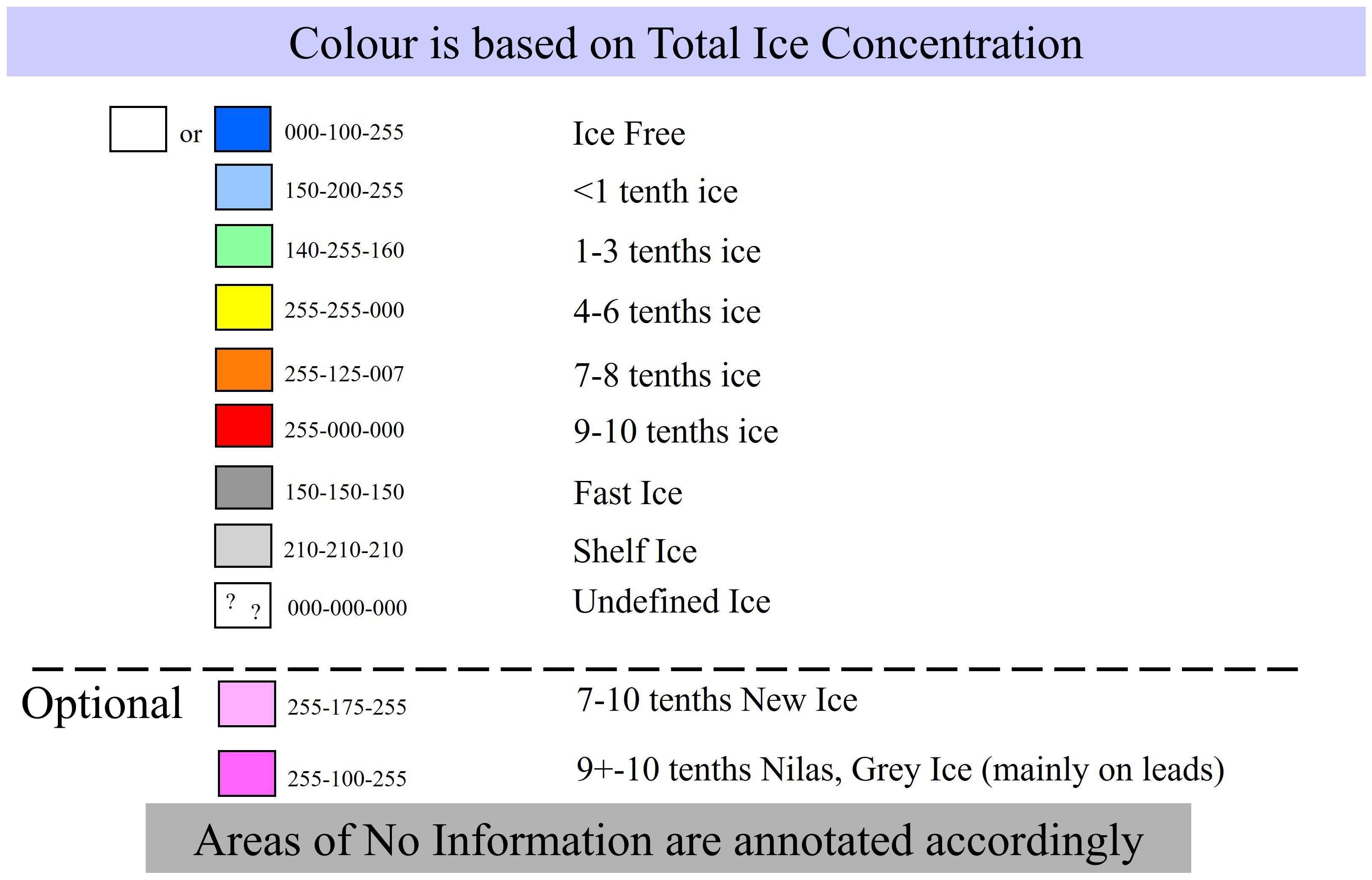
Figure 3. International ice concentration colour code. Adapted from JCOMM – Joint WMO-IOC Technical Commission for Oceanography and Marine Meteorology: Ice Chart Colour Code Standard Version 1.0, 2014, Tech. Rep. JCOMM-TR-024, WMO/TD-NO. 1215, World Meteorological Organization and Intergovernmental Oceanographic Commission, https://doi.org/10.25607/OBP-1077, 2014. a, b.
5.1.2 SIGRID-3: a vector archive format for sea ice charts
The Sub-Group on Sea Ice had previously developed the SIGRID (“Sea Ice Grid”) format for archiving ice chart information. SIGRID-1 and -2 both used grid-point schemes for capturing the information on an ice chart. While this format was amenable to digital archiving and large-scale climatological analysis, it represented a serious loss of chart information. At IICWG-II, a proposal was made for a new archive format based on vector shapefiles, an open Geographic Information System (GIS) format that could be used to faithfully reproduce the original chart. SIGRID-3 was adopted by the IICWG in 2003 and recommended to the ETSI as an international ice chart archiving and exchange standard. It was subsequently adopted as such and published as JCOMM Technical Report No. 23 (JCOMM Expert Team on Sea Ice, 2004 & 2010 Revision). It remains in use in 2024 to transfer ice charts electronically and is the basis for converting digital ice charts to Electronic Navigation System formats.
5.1.3 Navtex terminology
IICWG formed a working group at its meeting in 2010 to develop and test a standard set of terminology and abbreviations for NAVTEX safety bulletins extending Baltic Sea practice globally. These were adopted the following year and referred to JCOMM. JCOMM accepted the recommendation at its 4th meeting in 2012 and directed the Manual on Marine Meteorology be updated accordingly.
5.1.4 Ice hazard warning standards
In the late 2010s, several ice services, including the International Ice Patrol, were working on ways to depict hazards, specifically for icebergs and sea ice pressure. The aim was to make risk assessment, a requirement of the Polar Code for every voyage near ice, easier for mariners. In 2021, IICWG created two task teams – one to develop standards for iceberg hazard depiction and a parallel one for sea ice pressure. At time of writing in 2024, the work of these teams is continuing involving the science community and mariners.
5.1.5 Sea ice climate product standards
The role of climatological sea ice products has gained increased prominence with the Polar Code requirement for voyage-specific risk assessment. The IICWG recognized that there is a wide variation in the capacities of ice services to provide climate products and in the types of ice climate information made available. In 2023, a task team was created to develop guidance for the harmonization and standardization of sea ice climate products. This work is expected to take several years.
5.2 Ice service cooperation and collaboration
Cooperation and collaboration among the ice services is at the very heart of the IICWG’s reason for being. Every ice service faces financial, people, and time constraints. From the beginning, the IICWG participants recognized the benefits that could be achieved by working together to eliminate duplication and optimize their collective efforts (Figure 4). Collaboration at the operational level is not an easy task in a multi-national environment where every organization has its own policies, procedures, technology, and products, not to mention different languages and corporate cultures. While fundamentally similar at a high level, myriad small differences manifest themselves at the working level. Over the course of 25 years, the IICWG has made considerable progress towards interoperability on several fronts.
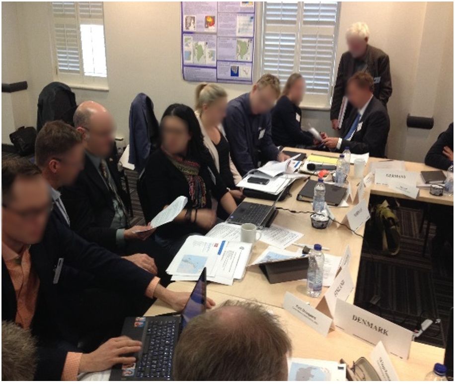
Figure 4. IICWG ice services actively work together and with stakeholders.
5.2.1 Arctic METAREA/NAVAREA coordination
In 2010, the WMO and IMO announced the creation of five new METAREAs/NAVAREAs in the Arctic. The IICWG immediately recognized that there was a need for coordination of ice information at the boundaries between METAREAs served by different ice services (Figure 5). Over the next few years, the IICWG worked with the ETSI to implement a system to maintain a consistent ice edge description around the Arctic Ocean so that ships travelling across multiple METAREAs would see a continuity of information.
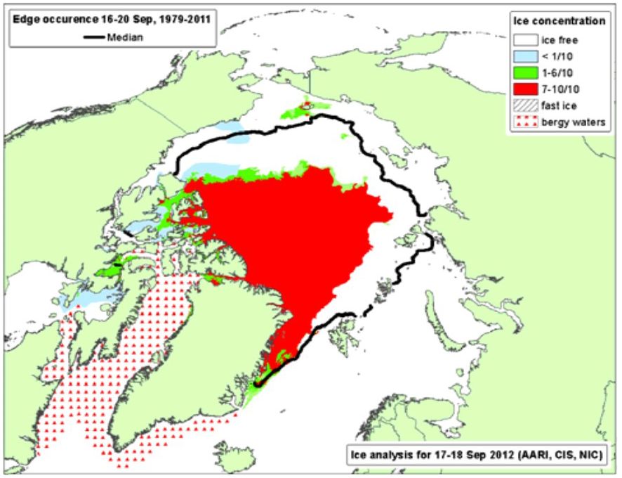
Figure 5. Ice Analysis for 17-18 September 2012. Prepared by AARI based on U.S., Canadian and Russian ice charts. Reproduced with permission from IICWG-XIII Meeting Report, https://nsidc.org/iicwg/iicwg-meetings.
5.2.2 Joint production of ice charts
In 2011, the U.S. National Ice Center and Russia’s Arctic and Antarctic Research Institute demonstrated capabilities to produce global ice charts based on an integration of charts from different services. Over the next several years, this capability was gradually operationalized so that, since 2015, ice charts around Antarctica have been produced jointly by the U.S., Russia, and Norway with Argentina and Chile contributing complementary regional charts.
In an initiative pre-dating the IICWG, the Canadian ice service and the U.S. National Ice Center jointly produced charts for the shared boundary waters of the Great Lakes. Seeing the advantages this affords both services, the Finnish and Swedish ice services began jointly producing Baltic Sea ice charts in 2017.
The Canadian ice service and the International Ice Patrol have developed a closely integrated iceberg monitoring and modelling system for their shared areas of responsibility in the North Atlantic. The Greenland ice service subsequently joined the collaboration to produce integrated iceberg distribution charts for the North Atlantic.
These initiatives have allowed ice services to concentrate on their local areas of responsibility. Avoiding duplication of effort allows all to devote their resources to providing better ice information services to mariners world-wide. It also provides redundancy of capabilities so that, if one of the partners suffers a system interruption, the others can take over to ensure continued distribution of vital marine safety products. This backup capability has been exercised several times in recent years.
5.2.3 Automation in ice service operations
As science and technology-based organizations, ice services have always been near the forefront of innovation. Automated processes have been integrated into ice service operations for decades and the IICWG has served to spread the experiences throughout the community. As this paper is being written, applications of artificial intelligence are leaping forward in every domain, ice analysis and forecasting being no exception. The IICWG members share knowledge about developments in Artificial Intelligence (AI) applications for satellite image analysis, sea ice and iceberg forecasts in the short- and long-term, ice hazard warnings and risk assessment, and others. The most important current discussions within the IICWG are about how various ice services are integrating automated processes into their operation and about how the human-machine mix will evolve.
5.3 Increasing the availability of ice information globally
The IICWG has strived to increase the availability of quality ice information to mariners in all the polar and sub-polar seas. In some cases, the information is produced but not easily accessible. In other cases, completely new products and services must be developed. Significant progress has been made in twenty-five years, but it is a continuing task to remain abreast of advancing technology and expanding areas and seasons of marine activity in the vicinity of ice.
5.3.1 Iceberg information in Europe
At the first meeting in 1999, a concern was raised about the availability of iceberg information for the North Atlantic. Trans-Atlantic ships faithfully use the International Ice Patrol (IIP) “Limit of All Known Ice” to determine their course across the ocean (Figure 6). The Canadian ice service produces similar charts for waters north of the IIP area of responsibility. While iceberg charts were broadcast daily from North America, they could not be reliably received by ships leaving Europe until they were midway across the Atlantic – after they had already set their great circle sailing route. Since the 1970’s, the German ice service had prepared hand-drawn iceberg charts 2-3 times a week, based on the daily IIP reports received via Global Telecommunications System. The charts were transmitted within the regular Marine Radiofacsimile Broadcast Service of the German Weather Service. Vessels were able to receive the iceberg information before setting out.
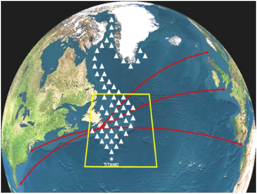
Figure 6. International ice patrol area of operations. Reproduced with permission from Michael Hicks, courtesy of International Ice Patrol.
As a result of the discussion at the IICWG, arrangements were made for the IIP and the Canadian ice service to send their iceberg charts via modern communication directly to the German Weather Service for retransmission from the European side of the North Atlantic.
Prior to 2005, the iceberg charts drawn by Canada and the IIP extended only as far north as southern Labrador. In that year, the Greenland ice service, joined to extend the charts to the bergy waters around the southern tip of Greenland.
5.3.2 Ice logistics portal
As an International Polar Year (IPY) project, the IICWG in conjunction with JCOMM, implemented the Ice Logistics Portal (JCOMM-IICWG, 2018) – so named because, while the IPY was focused on scientific research, ice information was essential for planning logistics for field research campaigns. The Ice Logistics Portal provided a convenient single point of access to all the ice charts produced for every region of the globe. Individual ice services submit their charts in SIGRID-3 format to the portal which provides a simple user interface.
Since 2018, the Ice Logistics Portal has featured prominently on the website of the Arctic Shipping Best Practices Information Forum, an initiative of the Arctic Council to aid in the implementation of the Polar Code. In 2022, discussions were initiated with PolarView aimed at integrating the Ice Logistics Portal with the PolarView portal. PolarView is a private company that operates a web portal delivering (mainly) satellite images of the Arctic and Antarctic sea ice and iceberg areas in near real-time. Thanks to European Commission and European Space Agency support, this service is free of charge to mariners and other users. It has become an extremely important resource for ice navigators. It is widely used to access satellite observations of ice-covered waters. Having ice charts available concurrently with satellite images will help mariners better interpret satellite imagery of ice and provide the greatest detail available for ice navigation.
5.3.3 Ice information for the Southern Ocean
Following earlier discussions about the lack of ice information for the Southern Ocean, the IICWG co-chairs wrote to the JCOMM in 2012 proposing that the Arctic METAREA ice information guidelines for the Global Maritime Distress and Safety System (GMDSS) and SafetyNet Marine Safety Information be implemented for the Southern Ocean. It took only three years, with assistance from the IICWG ice services, for the Argentine Navy Hydrographic Service to implement a permanent operational service issuing daily ice charts for its METAREA VI in 2015. Three years later, Chile began issuing regular ice charts for its METAREA XV.
The first two decades of the 2000’s witnessed an increase in the breakup of Antarctic ice shelves which, together with a recent decrease in the amount of protective sea ice, led to a greater number of icebergs drifting further north than usual and into global shipping lanes. Icebergs represent the greatest hazard to shipping in the Southern Ocean. In 2018, an IICWG Task Team was formed to consider what iceberg information could be provided to improve marine safety. Over the next few years, the International Ice Patrol iceberg drift and deterioration model was transferred to Argentina’s Naval Hydrographic Service for evaluation and adaptation to Antarctic waters. In 2022, Argentina started issuing iceberg density charts in the format recommended for standardization of iceberg hazard warnings that is under development.
In 2020, another IICWG Task Team was created to investigate the feasibility of implementing a hemispheric floating ice edge – the Southern Ocean Limit Of Known Ice (SOLOKI) – that would be maintained jointly by the five countries with METAREA responsibilities in the Southern Ocean (Figure 7). This task has proved daunting, requiring large quantities of satellite data from several space agencies, automated iceberg detection in the data, and modelling of iceberg drift and deterioration between observations. At time of writing in 2024, the work of this Task Team is continuing.
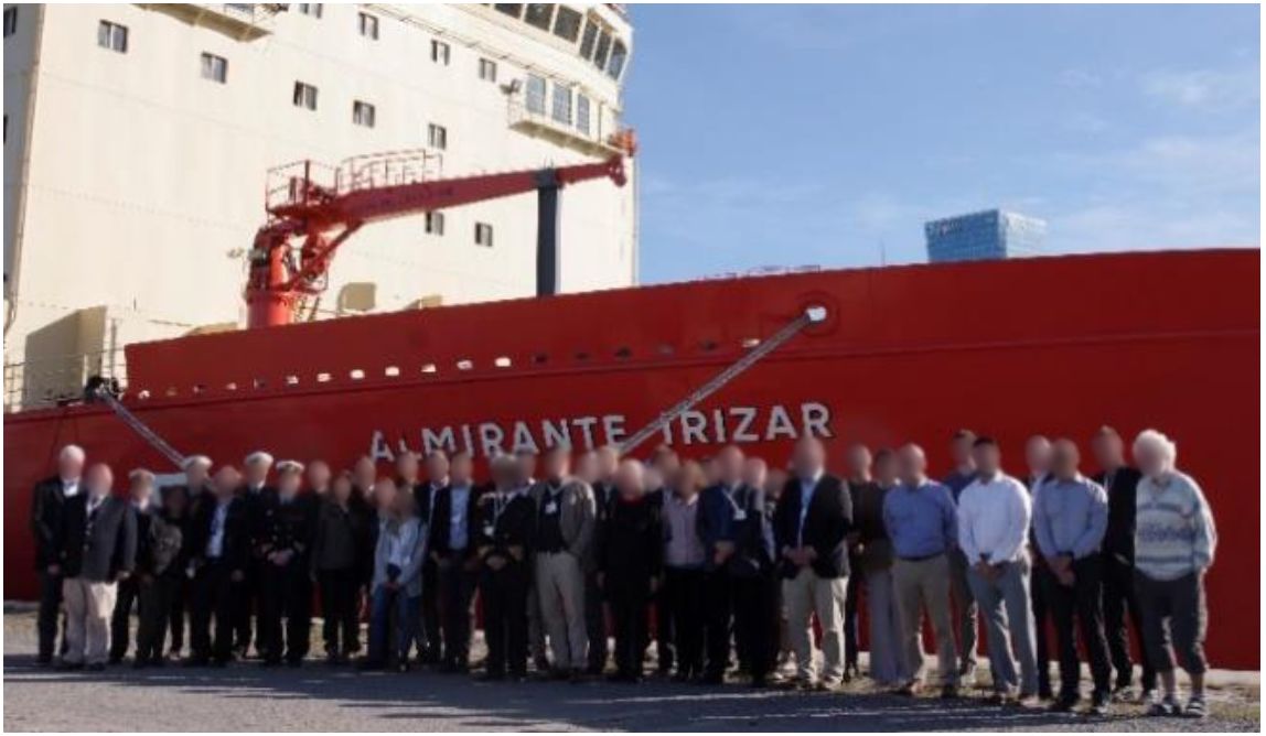
Figure 7. The participants in the IICWG toured the Argentine icebreaker A.R.A. Almirante Irizar. Reproduced with permission from IICWG, John Falkingham, IICWG-V Meeting Report, https://nsidc.org/iicwg/iicwg-meetings.
5.3.4 Ice information for Electronic Navigation Charts
The notion that ice information should become compatible with Electronic Navigation Charts (ENCs) and Electronic Chart Display and Information Systems (ECDIS) was raised at the very first IICWG meeting. It was obvious to all that ENCs represented the future of marine navigation and, since floating ice presents a major navigation hazard in the polar and sub-polar seas, the information traditionally portrayed in ice charts should be available to mariners’ ENC systems.
By the meeting in 2006, a Catalogue of Ice Objects had been prepared and subjected to critical review. The Catalogue describes, in rigorous detail, the ice features that can be displayed on an ENC together with their attributes. It represented the first major step towards the ability to provide ice information compatible with Electronic Navigation Charts (ENCs). This Catalogue was given to the Expert Team on Sea Ice for approval as the formal standard for exchanging ice information in a format compatible with ENCs. The ETSI had been denoted the “authority for ice information in ENCs” by the International Hydrographic Organization (IHO). ETSI approved the initial version of the Ice Objects Catalogue in March 2007, and it was subsequently adopted by the IHO as part of the S-57 Standard for the exchange of digital hydrographic data. In 2012, the German ice service, under the leadership of Jürgen Holfort, developed software to convert SIGRID-3 ice chart data to S-57 format for direct ingest into ENCs. The software was given freely to all IICWG ice services.
Over this same time, the IHO was recognizing that the S-57 standard was inadequate to cope with an expanding volume and variety of data and began working on the new S-100 framework for hydrographic standards. The IICWG was at the forefront of this work. The S-411 Standard for Ice Information (Benke, 2014), compatible within the S-100 framework, was adopted by the IHO in 2014, four years before the S-100 framework itself was approved. Software to convert SIGRID-3 to S-411 was shared freely with all ice services. By 2015, most ice charts were available in S-411 format from the Ice Logistics Portal.
The IICWG had, from time to time, discussed the desirability, from the mariner’s standpoint, of integrating ice information with weather, wave, and current information. A panel of experts at the 2020 meeting emphasized the idea that ice should not be treated separately from weather and wave information. The IHO also recognized this and allocated the standards S-412, S-413, and S-414 for weather and wave information (IHO, 2025). At the IICWG meeting in 2023, a session devoted to this topic recognized that the S-411 standard itself needed updating and that harmonization, if not direct integration, with weather and wave standards would be essential. With the termination of the JCOMM and ETSI, the WMO Expert Team on Maritime Safety (ET-MS) has assumed authority for S-411. The close working relationship that the IICWG had enjoyed with the ETSI was carried over into the ET-MS. The IICWG is deeply involved in the re-development of the standards for ice, weather, and wave information for ENCs.
5.4 Space agency engagement
Earth observation data from satellites is critical to the monitoring activities of all ice services, and so it is not surprising that the IICWG meetings included sessions on satellite missions as early as its second meeting. At that time, Synthetic Aperture Radar (SAR) data was used sparingly by most services because of its high cost. The single exception was the Canadian ice service which had access to large quantities of SAR data from the Canadian government RADARSAT program. Much discussion took place concerning the possibility of reducing the cost through bulk purchases and shared access to data. About the same time, the European Space Agency (ESA), in its planning for Envisat, was heading towards a commercialization policy for its new Envisat SAR data. This would have been financially detrimental to the ice services as public services.
The IICWG invited Mark Doherty, Director of Earth Observation at the European Space Agency (ESA), to its 5th meeting in Hamburg in April 2004 to present ESA’s views and become better informed on those of the ice services, the largest single group of users of satellite radar data. As a result of this discussion, the IICWG prepared a document that outlined the socio-economic benefits of freely available ice information as well as the specific requirements of the ice services for Earth observation data. The “Ice Information Services: Socio-Economic Benefits and Earth Observation Requirements” proved to be a valuable tool in discussions with several space agencies (Figure 8). It was updated in 2007 (Group on Earth Observations, 2007). Eventually, ESA adopted a policy of free and open access to most of its Earth observation data, a policy that the IICWG’s advocacy certainly helped to promote and that spurred other agencies to follow suit.
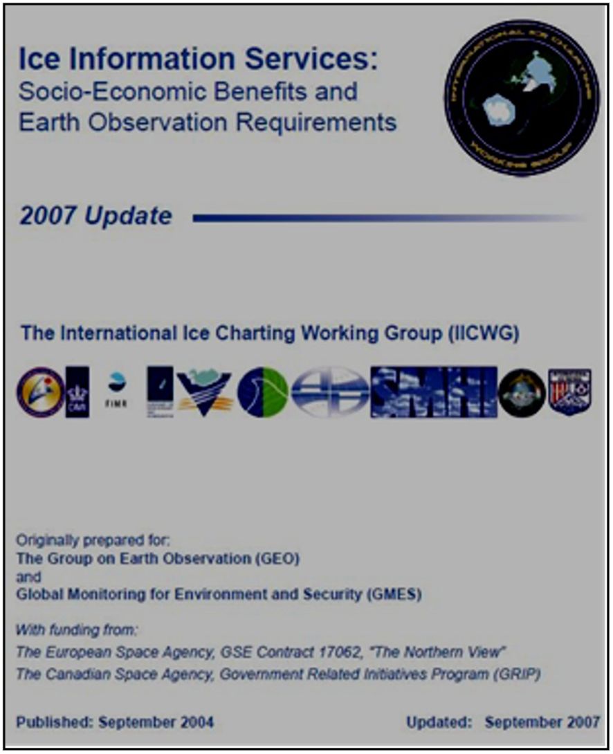
Figure 8. Socio-economic benefits and earth observation requirements. Reproduced with permission from Group on Earth Observations (2007).
Over the following years, annual meetings invariably included a session where space agencies, and more recently, private satellite data providers, could advise of future missions and receive feedback from the ice services. IICWG spokespersons were regularly invited to space agency planning sessions. The agencies appreciated the fact that the IICWG represented the global ice information services and were able, after internal discussion and debate, to bring forward comprehensive and coherent requirements for ice observations. In 2014, at the request of the Canadian Space Agency, John Falkingham, as IICWG Secretariat, authored Global Satellite Observation Requirements for Floating Ice (Falkingham, 2014), based on significant input from all the IICWG participants. In 2015, at ESA’s invitation, the IICWG developed an updated “statement of requirements for ice observations” for ESA’s 5th Earth Observations Programme.
In 2018, the IICWG advocated for both the “Radar Observing System for Europe in L-band (ROSE-L)” and the “Copernicus Imaging Microwave Radiometer (CIMR)” missions, both of which were subsequently approved. In fact, over the ensuing few years, the IICWG was instrumental in providing operational assessments of L-Band SAR data for ice and iceberg observation. Wolfgang Dierking, former chair of the IICWG Research Committee, directed the ESA project “Use of L- and C-band SAR Satellites for Sea Ice Monitoring (LC-ICE).” In addition to numerical simulations of L-Band response to sea ice and icebergs, the ice services of Norway, Greenland, Canada, Argentina, and the International Ice Patrol, conducted real-world assessments of L-band images of ice and icebergs. ROSE-L was subsequently approved by ESA for a future mission and the radar instrument is currently undergoing testing.
The Argentina Space Agency (CONAE) provided L-Band SAR data from its new SAOCOM mission for the LC-ICE project (Figure 9). That grew into the operational use of SAOCOM for monitoring sea ice and icebergs in the Southern Ocean.
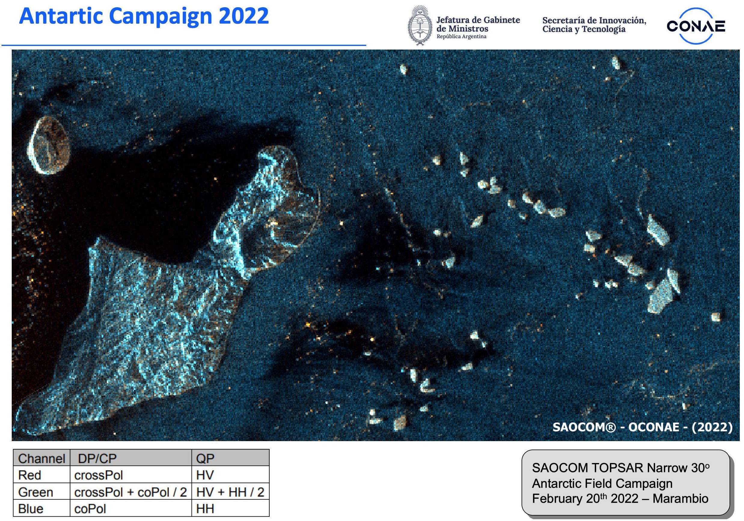
Figure 9. SAOCOM Imagery provided by CONAE. Source: Mario Camuyrano of CONAE. Permission from the Argentine Space Agency CONAE.
In 2022, one of the two ESA Sentinel-1 satellites failed in orbit, severely reducing the amount of SAR data available, particularly impacting ice monitoring in Antarctic waters. In the spirit of collaboration that the IICWG has fostered, the Canadian ice service asked the Canadian Space Agency to alter the RADARSAT Constellation Mission (RCM) mission profile to provide RCM SAR data to the Argentine ice service. It took a bit of time to accomplish, but RCM data eventually filled some critical holes in the observation gap. Without the IICWG, it is virtually certain that the Argentine ice service would not have even known that the RCM could help, much less been able to achieve it. In fact, RCM data was eventually made available to all ice services via the PolarView portal.
The continuing dialogue the IICWG has had with the space agencies throughout its history has proven greatly beneficial for ice monitoring and, by extension, for the safety of mariners in ice laden waters. The facts that there are now commitments to long-term, stable satellite programs for ice monitoring and a culture of free and open data exchange are due, in no small way, to the continuing efforts of the IICWG.
5.5 Engagement with mariners
The main raison d’être of the IICWG is to enhance the safety of marine operations in areas affected by floating ice. The annual meetings have regularly included sessions to interact with mariners to understand, not just their stated needs, but how they actually use ice information in their operations (Figure 10). Mariners have been regular participants in the IICWG meetings. Through presentations, expert panel discussions, small group breakout sessions, and general open discussion, ice services have learned in detail what mariners need in terms of ice information and how it is used. At the same time, mariners have gained a better appreciation for what is possible and how they can better interpret the information they receive.
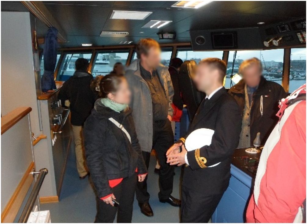
Figure 10. Aboard icelandic coast guard vessel in 2013.
5.5.1 Mariner training
At the meeting in 2011, David Jackson and Jürgen Holfort were nominated to lead a correspondence group to liaise with the International Maritime Organization (IMO) and the Nautical Institute about mariner training for ice information. The IMO was preparing to introduce the mandatory Polar Code with requirements for knowledge of ice and ice information services. The Nautical Institute, London (UK), representing over 7,000 mariners, was advocating for standardized training and certification in its Ice Navigator Project. Over the next couple of years, a curriculum for an ice information course was developed based on ice knowledge requirements developed by the IICWG. While not all the IICWG recommendations were adopted by the IMO, the major elements are embodied in the requirements for the Polar Code Basic and Advanced Polar Waters Training certificates.
The IICWG meeting in 2015 featured a session on “teaching sea ice and icebergs to mariners” initiated largely in response to the new Polar Code requirements for ice navigator training and certification (Figure 11). In breakout sessions with invited experts, the participants noted many opportunities for the ice services to help improve the training for ice navigators. A key recommendation was that this training should be done through a Maritime Training Institute with teachers with hands-on experience to ensure that it is compatible with seafarers’ certification requirements.
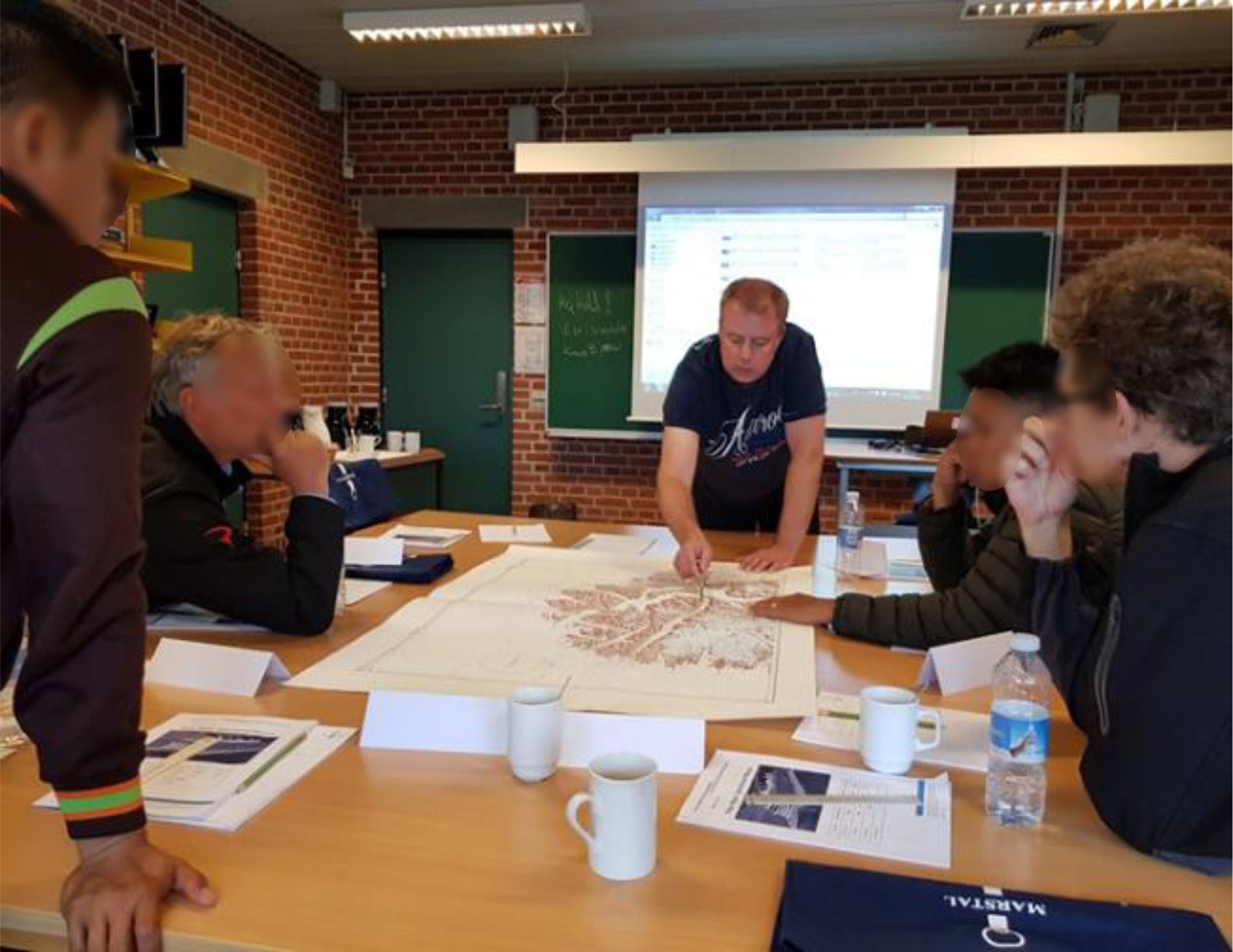
Figure 11. Ice expert giving ice information instruction to mariners. Photo by Bjørn Kay, SIMAC.
In 2018, representatives from three major maritime training institutes were invited to address the annual meeting and participate in a panel discussion that identified a number of deficiencies and opportunities for the ice services to improve how mariners are trained in the use of ice information. It became clear the maritime training institutes would appreciate closer ties to the ice services. It was equally clear that, because mariners must regularly re-certify their licenses, the connection between mariners and the training institutes lasts throughout their careers – a connection that ice services could benefit from. A follow-on survey of maritime training institutes identified challenges and areas for continued/focused/enhanced collaboration between ice services and maritime training centres.
In 2020, an IICWG task team under the leadership of Keld Qvistgaard, conducted the most extensive survey of polar mariners ever done. Ninety-five responses were received, the majority of which were from ship captains or crew with experience operating in ice in both Polar Regions with a wide range of vessels. Valuable information was received that the IICWG is using to develop better training tools with the maritime training centres. The survey also generated several ideas for pilot projects to explore new ice information products and services.
5.6 Arctic Marine Shipping Assessment
In the face of dramatically decreasing sea ice extent in the Arctic, the Arctic Council initiated the Arctic Marine Shipping Assessment (AMSA) (Arctic Council - PAME, 2009) to conduct a comprehensive study of current and future shipping activity in the Arctic. Lawson Brigham, the lead author for the AMSA, briefed the IICWG meeting in 2006 about the study and solicited input from the participants. John Falkingham subsequently agreed to be a lead author on the Marine Infrastructure chapter. Over the next three years, Mr. Falkingham sought the assistance of IICWG members who made significant contributions, reviewed numerous drafts, and ultimately approved the sections on ice information services that appear in the report. The AMSA was published in 2009 and has been through several updates and revisions over the ensuing years. A key recommendation of the original report was that states “support the updating and the mandatory application of … the Guidelines for Ships Operating in Arctic Ice-Covered Waters” – the forerunner of the Polar Code.
5.7 IMO polar code
IICWG participation in the development and implementation of the Polar Code included, not only ice navigator training requirements and the Arctic Council Best Practices Forum as mentioned earlier but also work on risk assessment. The Polar Code requires vessels operating in and near ice to conduct voyage-specific risk assessment. One tool used by mariners is POLARIS (Bond, 2022), a simple “go/no-go” indication based on ice conditions and ice class related vessel type (Figure 12). IICWG encouraged all ice services to include the stage of ice development (ice thickness) on all ice charts, a key input for POLARIS. Some ice services experimented with prototype products depicting POLARIS Risk Indicators directly and the IICWG considered whether product standards were required. However, at the meeting in 2023, the ice services came to a collective decision that national ice services do not necessarily need to produce POLARIS calculations, but they do need to provide data in flexible, digital formats for others to translate the information into POLARIS.
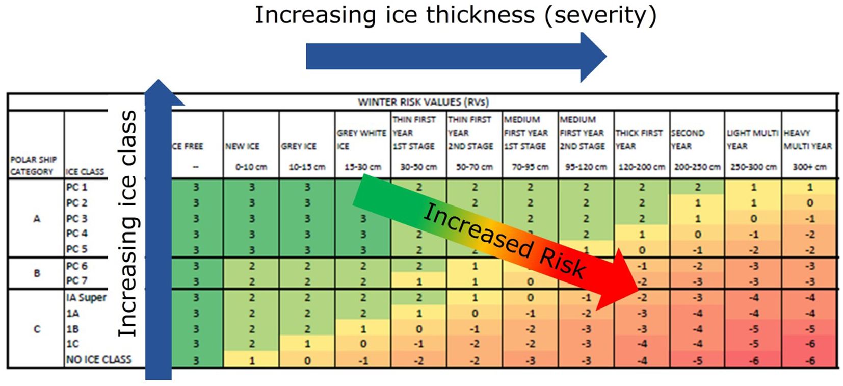
Figure 12. Polaris risk assessment table. Reproduced with permission from James Bond, courtesy of the American Bureau of Shipping.
Engagement with mariners led to discussions on conservatism in the charts produced by ice services that could lead to more restrictive POLARIS risk assessments than necessary. It was understood that this is related to the resolution of ice charts, covering broad areas with the observed or expected ice conditions. It may be one reason that, according to a 2022 survey, POLARIS was not being widely used by ice navigators. The IICWG continues to work with the maritime community as the Polar Code gains prominence.
While POLARIS was an easy solution for the risk assessment requirement, the IICWG recognized that, since it was developed in Canada based on Arctic ice conditions, it may not be applicable to the Antarctic. Projects were proposed to investigate but, to date, resources have not been found to conduct the necessary ship tests. The IICWG has asked the International Association of Antarctic Tour Operators (IAATO) to encourage their members to provide ice observations that would help with this initiative.
5.8 Emergency response
On occasion, vessels become trapped or damaged in sea ice precipitating action by emergency response organizations to assist the vessel, evacuate personnel, or contain potential oil pollution (Figure 13). These organizations, typically Coast Guards, need ice information to effectively plan and manage the response. An informal survey of ice services revealed an inconsistent mix of protocols and points of contact between emergency responders and ice service, often relying on personal contacts and informal knowledge. Following a session with the Icelandic Coast Guard at the meeting in 2013, the IICWG ice services agreed to several actions to improve effectiveness, including publication of emergency contact information on the IICWG website, agreement by the U.S. National Ice Center to be a contact point for emergency ice information world-wide, with direct contact numbers for the other ice services. In 2014, the IICWG requested and received clarification on how the International Charter for Space and Major Emergencies could be activated for sea ice emergencies.
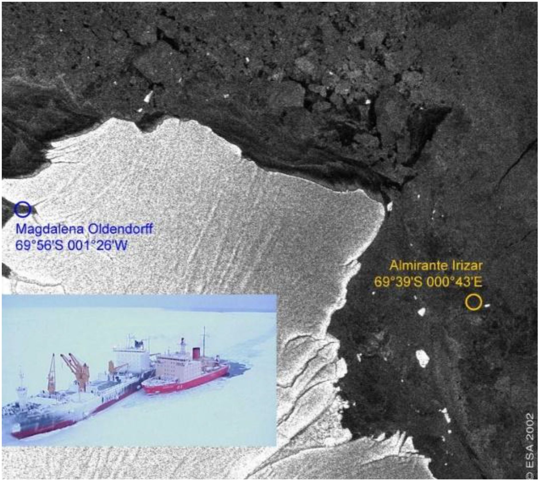
Figure 13. ENVISAT ASAR image (section) of 31-07-2002 used for rescue operation for M/V “Magdalena Oldendorff” ©ESA/BSH. Reproduced with permission from IICWG, Klaus Strübing, IICWG XXV Meeting Report, https://nsidc.org/iicwg/iicwg-meetings.
Oil response organizations were invited to the 2015 meeting to discuss how the ice services could best inform an incident response. The following year, a table-top exercise simulating a major oil spill in Arctic waters was held with ice services.
5.9 Ice analyst/forecaster training
In the Terms of Reference, training of ice analysts and forecasters was identified as a key activity of the IICWG. The Group recognized that, despite regional differences, there was much commonality between the ice services with respect to the production of ice information. Operational staff in all the services do very much the same work and need essentially the same training. The exchange of training information, practices, and materials has been a regular part of IICWG activities.
The first Ice Analysts’ Workshop convened at the German ice service in Rostock in June 2008 to bring working ice analysts together to share methods and best practices through hands-on exercises. Since then, six workshops have been held at six different ice services. The workshops have been extremely successful in promulgating best practices among the operational ice services, introducing ice analysts to new tools and techniques, and devising effective solutions to operational problems.
IICWG meetings originally included a “science day” to give an opportunity for ice forecasters and ice scientists to explore new ideas and developments. It soon became clear that one day was not sufficient for meaningful dialogue and the IICWG established the Sea Ice Data Assimilation and Modelling Working Group in 2006. To date, the Working Group has held 11 workshops to share developments on sea ice modelling and data assimilation – key aspects in forecasting ice conditions.
In 2013, a list of common training needs and tools was compiled. The list has grown with all ice services contributing materials and tools to assist with the training of ice analysts and forecasters. A task team was formed in 2019 to develop competency standards for ice analysts and forecasters as a means of ensuring a standard of quality of products and services offered by the ice services. The competency standards were approved by the WMO in 2023 (WMO, 2023).
5.10 The “soft” successes
Along with all the tangible accomplishments of the IICWG, the value of getting to know one another on a personal level, as well as on a corporate level, cannot be under-estimated. It has resulted in rapid, practical solutions to problems. Barriers of the unknown have been broken down so that ice service staff are less reticent to seek information or advice from their foreign counterparts. It is much easier to ask for help from someone you’ve shared a pint with or slid down a glacier slope beside (Figure 14). It is easier to refer clients to other ice services when they understand how those services work and what they are capable of. The safety of marine operations in the vicinity of ice has increased and overall service to the global shipping community has improved due to the spirit of collaboration that has been developed within the IICWG.
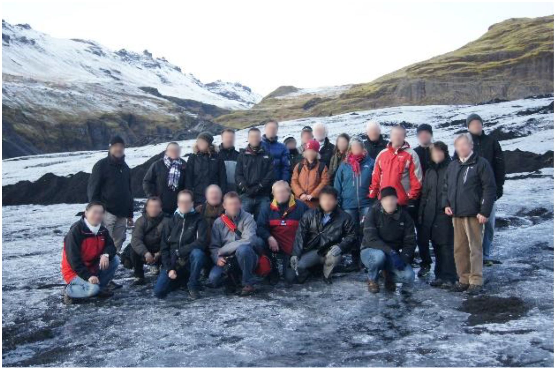
Figure 14. IICWG participants share time on a glacier in Iceland in 2013. Photo by IICWG.
6 Conclusion
Over twenty-five years, the IICWG has brought the national ice services together with their clients and partners in a growing bond of cooperation and collaboration. This paper has attempted to trace the path that the Group has travelled and chronicle its achievements. While much has been accomplished, there are still many challenges to be met, and the future will undoubtedly reveal many more. Building on the solid foundation that has been established, the IICWG is well positioned to address these challenges with solutions that are both innovative and pragmatic.
Bookending the first quarter century, the 25th annual meeting allocated some time to take stock of its achievements, to review and update its governance, but most importantly, to look to the future – to how science and technology advances can be employed to meet the evolving needs of mariners in a changing ice environment. In her closing address, Naval Postgraduate School President Vice Admiral Ann Rondeau, observed that: “The science by itself is extraordinary, but it needs to be transferred and applied to operations and actions.” (IICWG, 2024) - precisely what the IICWG has been advocating and facilitating for 25 years.
As long as ice floats in the ocean, there will be a need for ice information and a role for the International Ice Charting Working Group to bring the information providers together in the interest of safety in the icy seas.
Author’s note
The national ice services that participate in the IICWG fall within a variety of organizations in their respective countries’ structures. Some are a branch of the Navy or Coast Guard. Others fall within civilian environmental, meteorological, oceanographic, or transportation departments. Only a few, such as the Greenland Ice Service and the Canadian Ice Service (since re-named), actually have “Ice Service” in their formal name. For the sake of brevity and to avoid confusion, I have adopted, throughout this document, the term “<country> ice service” as a generic reference. For example, the “Argentina ice service” refers to the section of the Argentine Naval Hydrographic Service (Servicio de Hidrografía Naval) that provides ice information services. As an exception, I keep the title “U.S. National Ice Center” to distinguish it from the National Weather Service’s Alaska Sea Ice Program. I refer to the International Ice Patrol and British Antarctic Survey by their formal names. More information on the organizational structure of the ice services can be found on the IICWG web page (International Ice Charting Working Group).
I have not included specific references. Generally, the information is documented in the reports of the annual meetings of the IICWG (IICWG, n.d.). In addition, I have relied on my own recollections from fourteen years as secretariat.
Ethics Statement
Written informed consent was obtained from the individual(s) for the publication of any identifiable images or data included in this article.
Author contributions
JF: Writing – original draft, Writing – review & editing.
Funding
The author(s) declare that financial support was received for the research and/or publication of this article.
Acknowledgments
Many people have contributed to this paper and to the successes of the IICWG over the past 25 years. Some have passed on. Others have retired or moved to other challenges. Limitations of space and memory will not allow me to name them all. I would like to thank Klaus Strübing and Nick Hughes for their review and valuable additions to the manuscript. The author wishes to thank WMO's Global Cryosphere Watch for financial support to publish this paper.
Conflict of interest
The authors declares that the research was conducted in the absence of any commercial or financial relationships that could be construed as a potential conflict of interest.
Generative AI statement
The author(s) declare that no Generative AI was used in the creation of this manuscript.
Publisher’s note
All claims expressed in this article are solely those of the authors and do not necessarily represent those of their affiliated organizations, or those of the publisher, the editors and the reviewers. Any product that may be evaluated in this article, or claim that may be made by its manufacturer, is not guaranteed or endorsed by the publisher.
Supplementary material
The Supplementary Material for this article can be found online at: https://www.frontiersin.org/articles/10.3389/fmars.2025.1563900/full#supplementary-material
References
Arctic Council - PAME. (2009). Arctic Marine Shipping Assessment 2009 Report (Akureyri, Iceland: Arctic Council - Protection of the Arctic Marine Environment Working Group). Available at: https://www.pame.is/ourwork/arctic-shipping/previous-shipping-projects/arctic-marine-shipping-assessment/ (Accessed March 15, 2025).
Benke A. (2014). Ice Information Product Specfication. (Retrieved from Baltic Sea Ice Service). Available at: https://www.bsis-ice.de/S411/Docs/S-411_Specification_1_0_0_18032014.pdf (Accessed March 15, 2025).
Bond J. (2022). IMO Polaris Update: Current Usage and Status (London, U.K.: International Maritime Organization). Available at: https://wwwcdn.imo.org/localresources/en/About/Events/Documents/Polar%20Maritime%20Seminar%202022%20presentations/Day%201/10_James_Bond-IMO%20POLARIS%20Update%20%20Current%20Usage%20and%20Status.pdf (Accessed March 15, 2025).
Falkingham J. C. (2014). Global Satellite Observation Requirements for Floating Ice - Focusing on Synthetic Aperture Radar (Global Cryosphere Watch) (Geneva: WMO Polar Space Task Group). Available at: https://wmoomm.sharepoint.com/sites/wmocpdb/eve_activityarea/Forms/AllItems.aspx?id=%2Fsites%2Fwmocpdb%2Feve%5Factivityarea%2FWMO%20Space%20Programme%20%28WSP%29%2F2%2E%20Meetings%2FPSTG%2FPSTG%2D4%2FPSTG%2D4%5FDoc%5F08%2D04%5FGlobSatObsReq%2DFloatingIce%2Epdf&parent=%2Fsites%2Fwmocpdb%2Feve%5Factivityarea%2FWMO%20Space%20Programme%20%28WSP%29%2F2%2E%20Meetings%2FPSTG%2FPSTG%2D4&p=true&ga=1 (Accessed March 15, 2025).
Group on Earth Observations. (2007). Ice Information Services: Socio-Economic Benefits and Earth Observations Requirements (Boulder, Colorado: International Ice Charting Working Group). Available at: https://o365coloradoedu.sharepoint.com/sites/NSIDC-MT-IICWG/Shared%20Documents/Forms/AllItems.aspx?id=%2Fsites%2FNSIDC%2DMT%2DIICWG%2FShared%20Documents%2FGeneral%2FIICWG%2DBusiness%2FIICWG%5FSE%5F2007%5FUpdate%5FFinal%5F%2Epdf&parent=%2Fsites%2FNSIDC%2DM (Accessed March 15, 2025).
IHO. (2025) International Hydrographic Organization S-100 based Product Specifications WMO S-411 to S-420. Available online at: https://iho.int/en/wmo-s-411-to-s-420 (Accessed April 21, 2025).
IICWG. (n.d). IICWG Meetings (Boulder, Colorado: International Ice Charting Working Group). Available at: https://nsidc.org/noaa/iicwg/iicwg-meetings (Accessed March 15, 2025).
IICWG. (2016). IICWG Charter (Boulder, Colorado: International Ice Charting Working Group). Available at: https://nsidc.org/noaa/iicwg#anchor-iicwg-charter (Accessed March 15, 2025).
IICWG. (2024). Excutive Summary Report - 25th Meeting of the International Ice Charting Working Group (IICWG, Boulder, Colorado: International Ice Charting Working Group). Available at: https://nsidc.org/iicwg/iicwg-meetings (Accessed March 15, 2025).
JCOMM. (2023). Overview Joint WMO/IOC Technical Commission for Oceanography and Marine Meteorology (JCOMM) (Geneva: WMO). Available at: https://community.wmo.int/en/activity-areas/Marine/JCOMM/Overview#Programme-Areas (Accessed March 15, 2025).
JCOMM Expert Team on Sea Ice. (2004). Ice Chart Colour Code Standard - WMO/TD-No.1215 (Geneva: WMO). Available at: https://library.wmo.int/viewer/37175/download?file=wmo-td_1215_en.pdf&type=pdf&navigator=1 (Accessed March 15, 2025).
JCOMM Expert Team on Sea Ice. (2004 & 2010). SIGRID-3: A Vector Archive Format for Sea Ice Charts (Geneva: WMO). Available at: https://library.wmo.int/viewer/37171/download?file=wmo-td_1214_2010.pdf&type=pdf&navigator=1 (Accessed March 15, 2025).
JCOMM-IICWG. (2018). Ice Logistics Portal. (Cambridge: Polar View). Available online at: https://www.icelogistics.info/ (Accessed March 15, 2025).
WMO. (2023). Ice Forecasting Competency Framework (WMO Executive Council 76 - Record of Decisions) (Geneva: WMO). Available at: https://meetings.wmo.int/EC-76/_layouts/15/WopiFrame.aspx?sourcedoc={6b6e357a-5c57-499d-9d44-94914fc441d8}&action=default (Accessed March 15, 2025).
Keywords: sea ice, iceberg, polar, marine, shipping
Citation: Falkingham J (2025) The International Ice Charting Working Group: the first twenty-five years. Front. Mar. Sci. 12:1563900. doi: 10.3389/fmars.2025.1563900
Received: 20 January 2025; Accepted: 06 March 2025;
Published: 28 April 2025.
Edited by:
Wolfgang Dierking, Alfred Wegener Institute Helmholtz Centre for Polar and Marine Research (AWI), GermanyReviewed by:
Torbjorn Eltoft, UiT The Arctic University of Norway, NorwayJan L. Lieser, Bureau of Meteorology, Australia
Day Qvistgaard, Danish Meteorological Institute (DMI), Denmark
Copyright © 2025 Falkingham. This is an open-access article distributed under the terms of the Creative Commons Attribution License (CC BY). The use, distribution or reproduction in other forums is permitted, provided the original author(s) and the copyright owner(s) are credited and that the original publication in this journal is cited, in accordance with accepted academic practice. No use, distribution or reproduction is permitted which does not comply with these terms.
*Correspondence: John Falkingham, am9obi5mYWxraW5naGFtQHJvZ2Vycy5jb20=