 Linghao Kong1,2,3,4
 Hongxian Chu3
 Guohua Hou5Jiao Zeng3Liyuan Zhao3Xiangcai Han3Yachao Li3Faqiao Zhou3Meiling Yin3
 Xuzhen Zhang3*
- 1School of Ocean Sciences, China University of Geosciences (Beijing), Beijing, China
- 2Observation and Research Station of Seawater Intrusion and Soil Salinization, Laizhou Bay, Ministry of Natural Resources, Qingdao, Shandong, China
- 3Yantai Center of Coastal Zone Geological Survey, China Geological Survey, Yantai, China
- 4Ministry of Natural Resources Observation and Research Station of Land-Sea Interaction Field in the Yellow River Estuary, Yantai, China
- 5Qingdao Institute of Marine Geology, China Geological Survey, Qingdao, China
Sea (salt) water intrusion is a significant and ongoing geological disaster, and in recent years, it has become a notable concern for Laizhou City, Shandong Province. To identify the characteristics and mechanism of sea (salt) water intrusion in Laizhou City, samples of different types of water bodies (such as seawater, freshwater, slightly brackish water, brackish water, saline water, and brine) were systematically collected from the coastal zone area. The hydrochemical composition and evolution characteristics of the water bodies and the current situation, trends, and causes of sea (salt) water intrusion were analyzed. In 2020, the sea (salt) water intrusion reached 645.76 km2 (including 151.64 km2 of serious intrusion area), which is the largest ever recorded. The sea (salt) water intrusion had a strip-sheet distribution. From land to sea, groundwater gradually transitioned from the HCO3·SO4·Cl-Ca type to SO4·Cl-Na·Ca and SO4·Cl-Na types and then evolved to the Cl-Na type. Furthermore, from land to sea, the dominant cations and anions shifted from Ca2+ and HCO3- to Na+ and Cl-. The influence of seawater or brine gradually increased, that of Ca2+ and HCO3- gradually decreased; whereas that of Cl- and Na+ gradually increased, showing a division zone of freshwater → slightly brackish water → brackish water → saline water → seawater (brine) in the macroscopic territory. The freshwater, slightly brackish water, and brackish water bodies in the study area were controlled by evaporation and concentration processes and rock weathering leaching, whereas the saline water and brine were primarily controlled by evaporation and concentration processes. Groundwater salinity in the study area mainly originates from sea (salt) water intrusion, and locally groundwater salinity mainly originates from mineral dissolution or human activities. In addition, significant cation exchange adsorption occurred in slightly brackish and brackish water. Overall, these results will help to prevent and control seawater intrusions and improve disaster management.
1 Introduction
Sea (salt) water intrusion is the process and phenomenon of sea (salt) water bodies invading freshwater bodies along underground pore fissures due to natural and anthropogenic factors. This process can change the hydrodynamic conditions of underground aquifers in coastal areas, polluting underground freshwater (Chen, 2013; Sallam, 2022; Xaza et al., 2023). In China's coastal areas, sea (salt) water intrusion is considered a significant and ongoing geological disaster (Sun et al., 2006).
Groundwater quality is affected by hydrogeochemical processes that occur within the groundwater system and water-aquifer matrix interactions (Kim et al., 2019). The chemical and geological characteristics of an aquifer can cause hydrogeochemical processes to vary both temporally and spatially (Abu-alnaeem et al., 2018; Salem et al., 2022). The residence time of groundwater within an aquifer also affects the groundwater chemistry (Okofo et al., 2022). The main processes affecting groundwater chemistry and water quality in coastal areas are rock-water interactions, rock weathering dissolution, ion exchange, and sea (salt) water intrusion (Balasubramanian et al., 2022; Arroyo-Figueroa et al., 2024). The dissolution of rocks due to weathering usually leads to increases in the major cation content of groundwater (Walraevens et al., 2018; Zhang et al., 2020), and rock weathering produces large quantities of clay minerals, which in turn undergo cation exchange with intruding sea (salt) water (Wu et al., 1996; Yusuf et al., 2021), thus profoundly changing the groundwater quality. Population activities, such as industrial and agricultural mining, can also have a significant impact on sea (salt) water intrusion (Li, 2011; Zhao et al., 2017; Guo et al., 2021).
Researchers have used a variety of methods to study sea (salt) water intrusions. The hydrochemical characteristics and evolutionary processes of coastal groundwater have been investigated using Piper and Gibbs diagrams, mineral saturation indices, ion ratio analyses, and numerical modeling to elucidate sea (salt) water intrusion mechanisms (Gibbs, 1970; McLean et al., 2000; Lu et al., 2010; Hou et al., 2019; Meyer et al., 2019; Yusuf et al., 2021; Han, 2023; Chen Y et al., 2024; Moorthy et al., 2024; Samanta et al., 2024). Since 1975, researchers in China have investigated sea (salt) water intrusions and successfully developed groundwater quality modeling and sea (salt) water intrusion monitoring and elucidated sea (salt) water intrusion mechanisms and saline and freshwater interfacial transport laws (Wu et al., 1996; Guo et al., 2003; Tang et al., 2007; Chen, 2010; Han et al., 2014; Dong et al., 2018; Wang et al., 2022; Chang et al., 2024; Chen B et al., 2024; Zhang et al., 2024). These research results are valuable for understanding the process and mechanism of sea (salt) water intrusion.
Laizhou City is located on the east coast of the Laizhou Bay, northwest of the Jiaodong Peninsula. It was one of the first cities in China to identify seawater intrusion (the first discovery was in 1976) and has since been considered a typical seawater intrusion area in China due to its rapid economic development, increased water consumption for industry and agriculture, and over-exploitation of groundwater (Zhao et al., 2017; Guo et al., 2021). These characteristics have led to the formation of a groundwater landing funnel in the coastal plain, which resulted in the further development of seawater intrusions and had a serious impact on the ecological environment (Zhang, 2004; Huang et al., 2023).
Previous researchers have investigated sea (salt) water intrusions in Laizhou City using water chemical analysis, groundwater isotope studies, groundwater statistic measurements, monitoring profile construction, numerical simulations, remote sensing interpretations, ecological studies, and models (Yin et al., 1992; Wu et al., 1994; Han et al., 2011; Liu et al., 2023; Cheng et al., 2016; He et al., 2018; Cui et al., 2024). Nevertheless, studies related to sea (salt) water intrusion in Laizhou City have predominantly focused on the period before 2016, and there has been a gradual decrease in the number of studies in recent years. The monitoring work used in this study shows that sea (salt) water intrusions can continue to expand, and their characteristics change, leading to new threats. However, detailed classification studies of groundwater that could help elucidate the evolution of different water bodies, such as freshwater, slightly brackish water, and brackish water, are limited, as are the classification management and hierarchical control of groundwater. Consequently, further research on sea (salt) water intrusion in the coastal area of Laizhou City is required.
To address this issue, data were collected, field investigations were performed, and indoor analysis and testing were conducted based on the main components of seawater, brine, freshwater, and other water bodies to elucidate the hydrochemical composition of different water body types and evolution based on statistical analyses and explore current sea (salt) water intrusion conditions as well as the trends and underlying factors.
2 Materials and methods
2.1 Study area
The study area of Laizhou City in northern Shandong Province, China, borders the Bohai Sea and has a total area of 1928 km2, a coastline of 108 km (Figure 1), and a resident population of 824,700. This region has a continental climate in the north-temperate East Asian monsoon zone, with noticeable changes during the four seasons. The mean annual temperature and precipitation were 12.9 °C and 610 mm, respectively (Huang et al., 2023). The topography of Laizhou City is high and mountainous in the southeast, and it shows a gradually stepwise decline to the coast in the northwest (Figure 2). This decline can be divided into five landform types: eroded low mountains, denuded hills, pre-mountainous hillocks, alluvial flood plains, and coastal plains (Li, 2011). Fifteen major rivers are found in Laizhou City, and they are primarily small and medium sized and generally originate from the southeastern mountainous areas. These rivers have strong seasonality, a short source, rapid flow, high peaks, high volumes, and steep rises and falls, and the flood discharge is affected by the top support of the tide. In addition to the Xiaogu River to the east, which flows into the Dagu River and then into the Yellow Sea, the Wang, Baisha, Su Guo, Zhuqiao, Nanyang, and other rivers flow northward into the Bohai Sea. Laizhou Bay has experienced three sea transgression and retrogression events since the Late Pleistocene (Gao et al., 2018). Consequently, the coastal plain area southwest of Laizhou City produces interactive depositions of land and sea strata with a complex aquifer structure, which is relatively rich in brine resources.
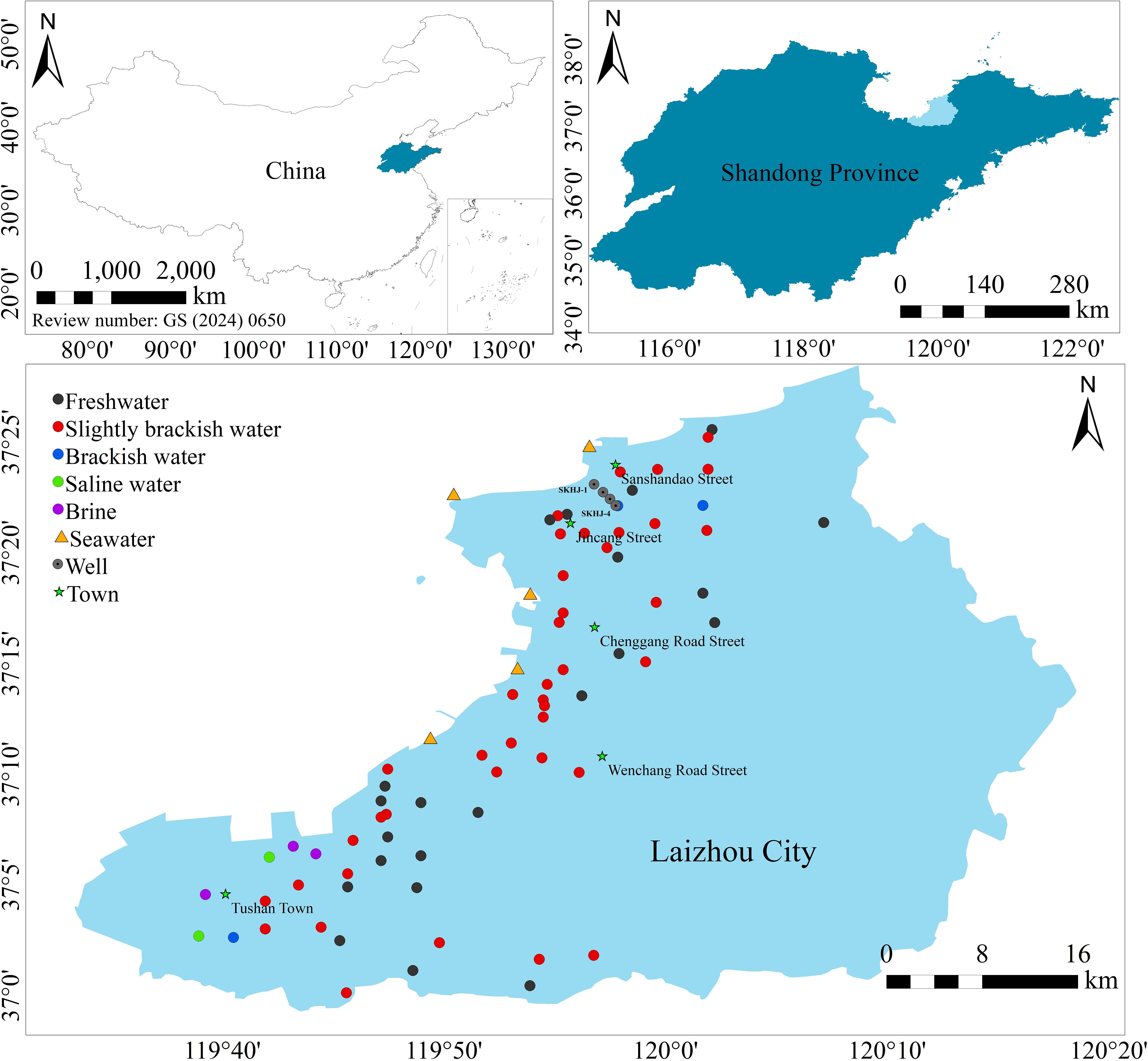
Figure 1. Groundwater sampling locations in the coastal area of Laizhou City.
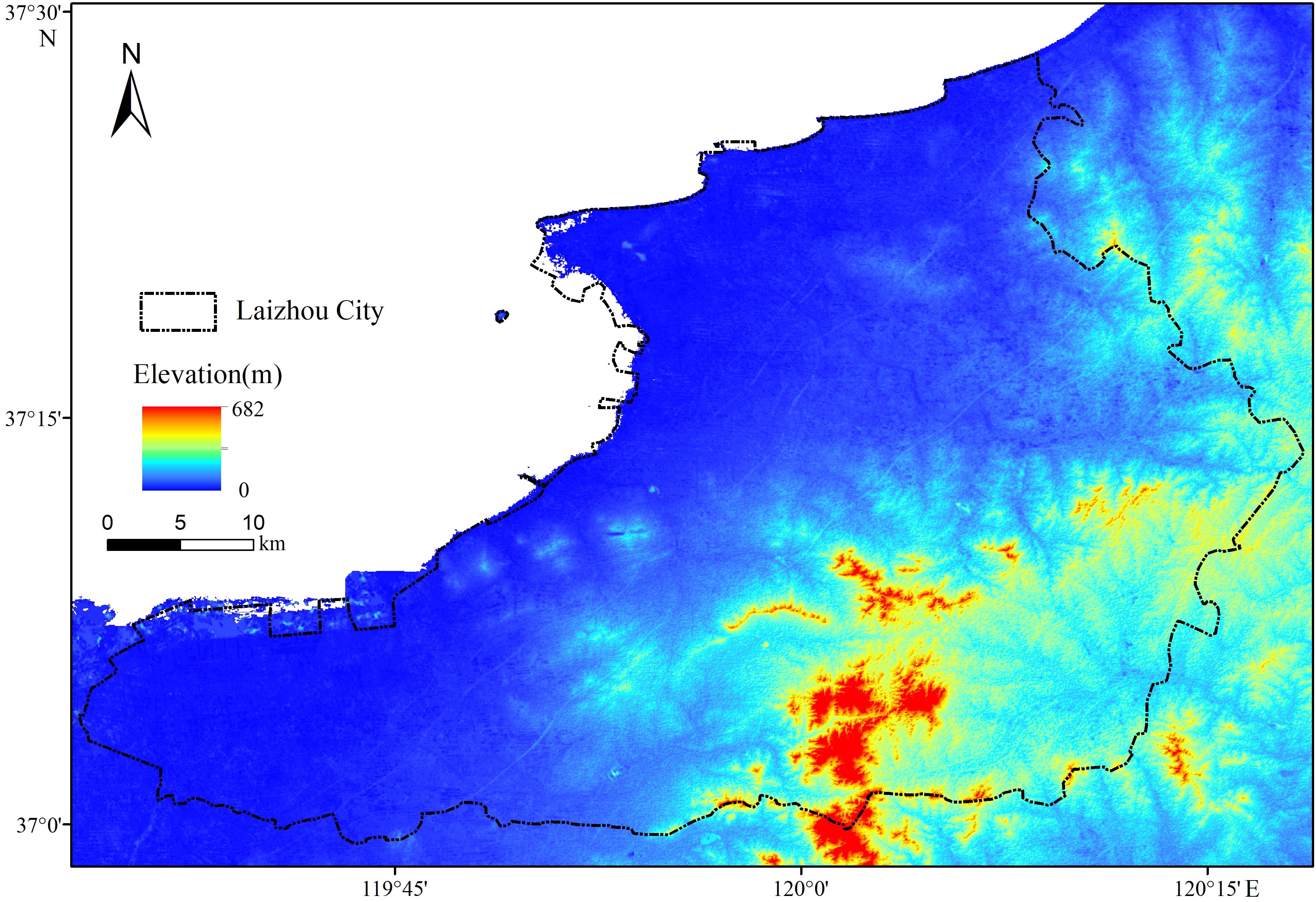
Figure 2. Topography in Laizhou City (from the ASTER GDEM 30M).
The region is tectonically located in the northwestern Jiaodong uplift zone to the east of the Yimu rift. The fracture structure of the study area has developed predominantly in the north-east direction, with the development of secondary north-west fractures. The stratigraphy of the study area primarily consisted of metamorphic rocks from the Jiaodong and Fanzishan Groups (Figure 3). The Quaternary System is widely distributed in Laizhou, primarily in the coastal plain. The coastal plain comprises alluvial, floodplain, and marine accumulation strata with a thickness of 20–60 m. The sand layer is thicker, with coarse grains and better water permeability, and the vertical structure of the aquifer is simpler, especially the continuous distribution of the Holocene marine accumulation layer, which provides a good surface channel for the intrusion of sea (salt) water. In addition, while invading the aquifer of the Quaternary System, sea (salt) water will directly expand to the bedrock under the Quaternary System, and the weathering fissures, tectonic fissures, and fault fracture zones in the bedrock aquifer are important channels for the invasion of seawater in Laizhou City. Moreover, the development of basal fracture structures vertically intersect with the coastline in a northwesterly direction, thus providing a strong connection with seawater (Yin et al., 1992).
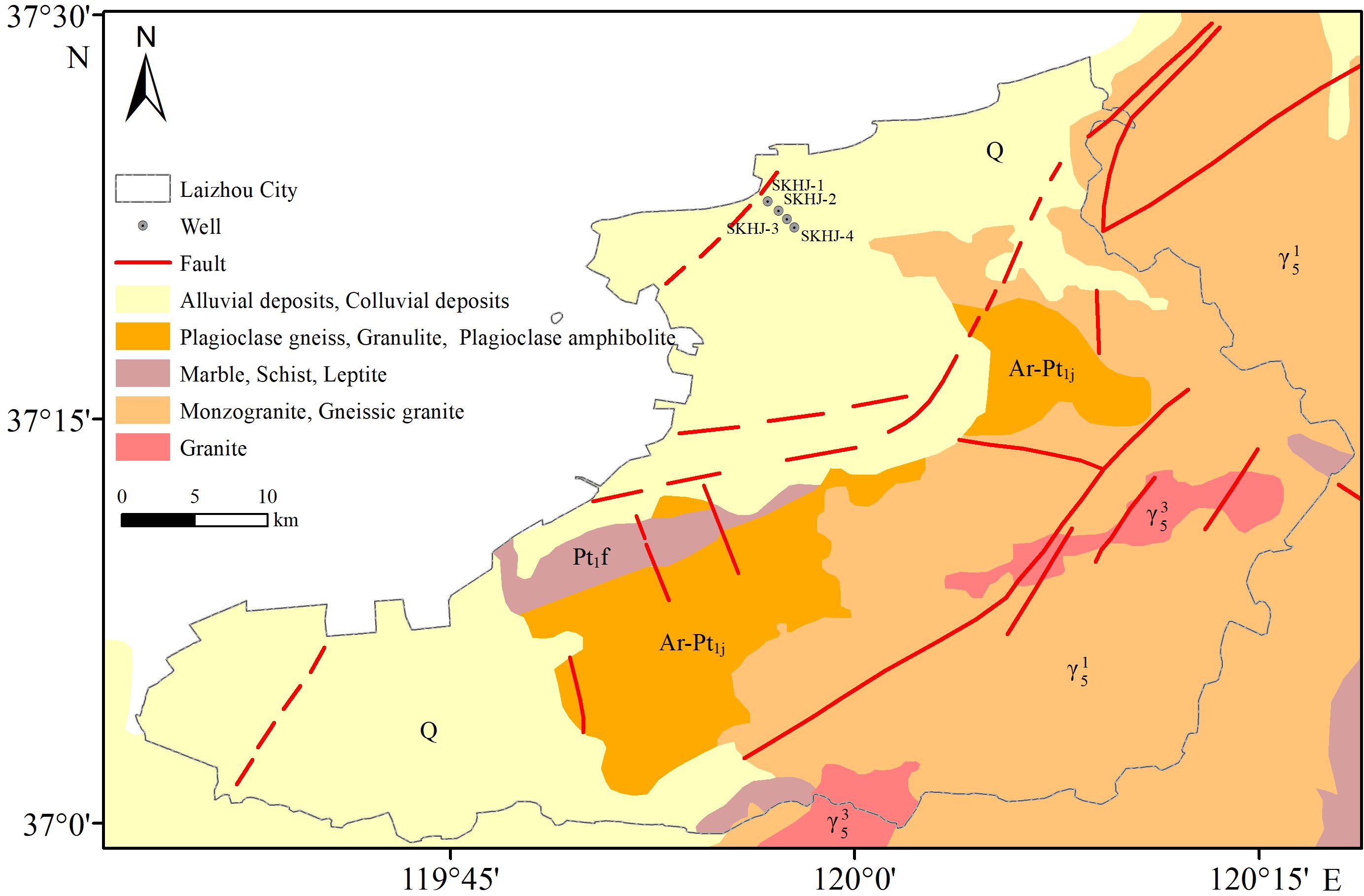
Figure 3. Geological sketch map of Laizhou City.
2.2 Sample collection and processing
The sampling strategy prioritized the Quaternary system distribution zones to systematically assess the spatial heterogeneity of sea (salt) water intrusion, which was further correlated with local hydraulic conductivity variations in the aquifer. In early September 2020, groundwater samples were collected from the coastal plain area of Laizhou City using a Baylor tube collector. Seventy groundwater samples were collected and tested on-site for pH, EC, mineralization, dissolved oxygen, and water temperature using a Hash DS5 water quality meter. Groundwater can be classified as freshwater (< 1 g/L total dissolved solids (TDS)), slightly brackish water (1–3 g/L TDS), brackish water (3–10 g/L TDS), saline water (10–50 g/L TDS), and brine (> 50 g/L TDS) according to the TDS (Wan et al., 2012; Zhou, 2013). Of the 70 groundwater samples collected, 22 were freshwater, 40 were slightly brackish, 3 were brackish, 2 were saline, and 3 were brine. To facilitate a comparative study, the project team synchronously collected five groups of seawater samples. The sampling point distribution is shown in Figure 1.
The samples were tested at the Analytical Testing Laboratory of the University of Science and Technology Beijing. Potassium and sodium were determined using Flame Atomic Absorption pectrophotometry (FP640), calcium and magnesium were determined using Disodium EDTA titration, carbonate and bicarbonate were determined using titration, nitrate nitrogen was determined using ultraviolet spectrophotometry (UV-1800), sulfate was determined using turbidimetric assay (UV-1800), and chloride was determined by silver titration. The balance error of each ion in the sample is within ±5%, and the test data are reliable.
2.3 Data analyses
Based on the Technical Procedures for the Monitoring and Evaluation of Seawater Intrusion (HY/T 0314-2021: Ministry of Natural Resources of the People's Republic of China, 2021), sea (salt) water intrusions can be classified as no intrusion, mild intrusion, and severe intrusion (Wang et al., 2014; detailed in Table 1). Cl- in groundwater has high solubility and does not easily precipitate. It is one of the most stable ions in the water body and can directly reflect seawater intrusion, and it represents the most direct and sensitive indicator for judging the intrusion of sea (salt) water and the most commonly used indicator (Zhao, 1998; Li and Ye, 2016; Zhao et al., 2017; Li et al., 2020; Chen et al., 2024). The results were statistically analyzed using EXCEL, including mass concentration, mg equivalent concentration, and ionic ratio characteristics. Relevant graphs, including Piper and Gibbs diagrams, were produced using Origin software. ArcGIS was used to produce a distribution map of the sea (salt) water intrusion, and a Piper diagram and Shukarev's classification were used to determine the water chemistry type. In addition, PHREEQC software was used to calculate the saturation index of minerals in the water column.
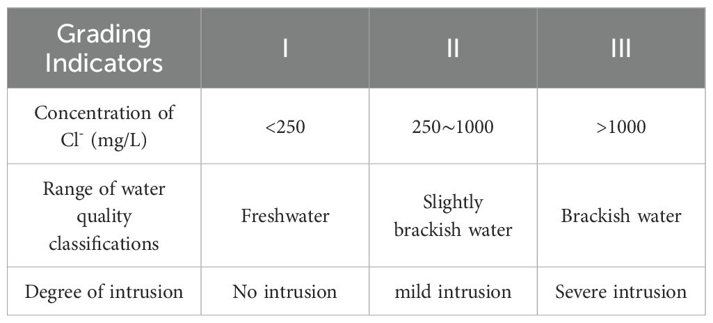
Table 1. Hydrochemical indicators of sea (salt) water intrusion and intrusion level.
3 Results and discussion
3.1 Spatial distribution characteristics of sea (salt) water intrusions
In addition to the actual situation in Laizhou City, this study used the Cl- mass concentration distribution to characterize the spatial distribution and degree of seawater intrusion. ArcGIS software was used to draw the distribution map of the current sea (salt) water intrusion in the coastal area of Laizhou City (Figure 4).

Figure 4. Map of current seawater intrusions in Laizhou City (a: from the 'Geological sketch map of Laizhou City').
The Laizhou City sea (salt) water intrusion area was significant and widespread, and it showed a strip-piece distribution. In 2020, the sea (salt) water intrusion reached 645.76 km2 (including 151.64 km2 of serious intrusion area). Serious intrusion areas were primarily distributed in Tushan Town and showed a concentrated and continuous spread. For the distribution of brine resources, TDS reached up to 83583.90 mg/L, with the highest concentration of chlorine ions reaching up to 47,950 mg/L. Second, in the southern part of Sanshandao Street, chlorine ions, which were distributed in the form of an isolated island, reached up to 2,393 mg/L. In the north of Laizhou City, Sanshandao Street and Jincang Street had mild seawater intrusion areas, and Chenggang Road Street was covered by a large intrusion area. The seawater intrusion in this area was 6.37–10.74 km inland. To the south, in the central coastal area, the intrusion width gradually decreased due to the outcropping of bedrock and the thinning of the surrounding Quaternary strata (Figure 3). The intrusion distance in the central coastal area was 1.31–5.85 km. In the southwestern region, the quaternary stratigraphy exhibited increasing thickness and carbonate rocks were locally distributed (Li, 2005), and the mild seawater intrusion area showed a piece-like distribution. The coastal plain southwest of Laizhou City was almost entirely in the sea (salt) water intrusion area. The intrusion-free area was primarily distributed in the central and southeastern inland areas, and a small number of freshwater wells was distributed in the intrusion area in the form of single points, which may represent local freshwater bodies produced by rainfall.
Sea (salt) water intrusion is closely related to the topography, geomorphology, hydrogeological conditions, and intrusion mode (Zhao, 1998). The northern part of Laizhou City is a pre-mountain floodplain and coastal plain with a wide area (Figure 2). The quaternary aquifer is narrow at approximately 20–60 m wide, and it contains 1–2 aquifers (Figure 5). The lower part of the bedrock is predominantly metamorphic granite, whereas the bedrock surface is more strongly weathered and is the site of fissure development. The whole loose layer of the quaternary system and the bedrock surface layer provide a good passage for the intrusion of seawater. In the middle of Laizhou City, the terrain is higher, bedrock is exposed in a large area, and the quaternary system is narrower (Figure 3); essentially, no seawater intrusion. The southwestern part of Laizhou City has abundant brine resources, and the quaternary system is widely distributed. The thickness varies greatly, and local karst development is coupled with strong anthropogenic activities, resulting in sea (salt) water intrusion into a large area. This study assessed the current sea (salt) water intrusion in the study area and obtained the geological characteristics of the aquifer in the northern coastal part of the study area. The data provide theoretical support for the design and construction of barriers to prevent the intrusion of sea (salt) water and for monitoring and early warning systems.

Figure 5. Typical geological profile of the coastal plain in the northern part of Laizhou City.
3.2 Hydrochemical parameter characterization
The hydrochemical parameters of the studied water bodies are summarized in Table 2. The pH of the groundwater in the study area ranged from 6.17 to 8.88 and was dominated by weakly acidic to weakly alkaline water. From freshwater to brine, the average TDS values showed a rapid increase, with 68042.19 mg/L for brine, 30902.4 mg/L for seawater, and 780 mg/L for freshwater, with brine and seawater being 87.23 and 39.62 times that of freshwater, respectively. In terms of the size of the average concentration of cations and anions, brine and seawater were Na+ >Mg2+ > Ca2+ > K+ and Cl- > SO42- > HCO3-, saline water was Na+ > Mg2+ > Ca2+ > K+ and Cl- > SO42- > HCO3-, brackish water was Na+ > Ca2+ > Mg2+ > K+ and Cl- > SO42- > HCO3-, and slightly brackish water was Na+ > Ca2+ > Mg2+ > K+ and Cl- > SO42- > HCO3-, and fresh water was Ca2+ > Na+ > Mg2+ > K+ and HCO3- > SO42- > Cl-. From sea (salt) water to fresh water, the dominant cations transition from Na+ and Mg2+ to Ca2+ and Na+. Except for the freshwater anion average concentration size of HCO3- > SO42- > Cl-, the rest of the water bodies exhibited Cl- > SO42- > HCO3-, indicating that the anion dominant in the groundwater will be swiftly transformed from HCO3- to Cl- once the groundwater has been intruded by sea (salt) water. The coefficients of variation for each ion in the seawater and brine were low, indicating that the spatial distribution of each ion in the two water bodies was relatively uniform. The coefficients of variation for K+ were greater than 1 in freshwater, slightly brackish water, and saline water, indicating strong variability. This finding demonstrated that the spatial distribution of K+ was significantly uneven and affected by the natural world and anthropogenic activities.
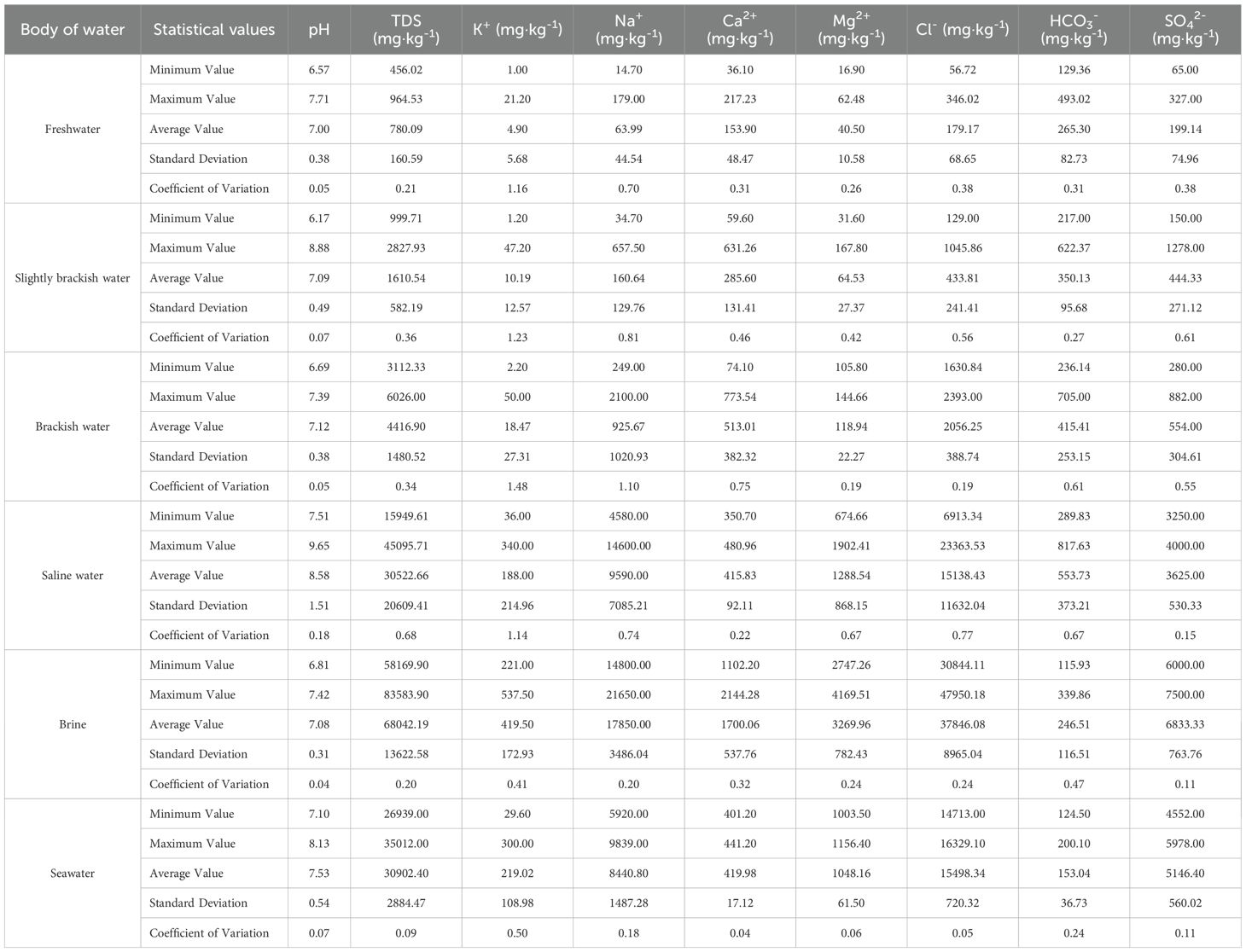
Table 2. Groundwater and seawater hydrochemical parameters in the study area.
3.3 Hydrochemical composition and evolutionary mechanisms
3.3.1 Piper diagram
The Piper diagram can be used to understand the main ion composition and evolutionary characteristics of a water body (Lu et al., 2010), and the Shukarev classification can be used to delineate groundwater chemical types (Wang et al., 2023). Seawater, brine, and saline water cations are primarily composed of K+ and Na+. The percentage of Na+ mg equivalents reaches more than 70% (Figure 6). In contrast, anions are primarily composed of Cl-, with the percentage of mg equivalents > 65%, and the percentage of SO42- mg equivalents ranging from 10% to 30%. The water chemistry of the brine and seawater is the Cl-Na type, while saline water is the Cl-Na and SO4·Cl-Na types. The distribution of the chemical types of brackish, slightly brackish, and freshwater is relatively dispersed, with 9 freshwater chemical types, primarily HCO3·SO4·Cl-Ca type, followed by HCO3·Cl-Ca, HCO3·Cl-Ca·Mg, HCO3·SO4-Ca, and SO4·Cl-Ca·Mg types; and 14 slightly brackish water chemical types, primarily SO4·Cl-Na·Ca and SO4·Cl-Na types, followed by HCO3·SO4·Cl-Na·Ca, HCO3·SO4·Cl-Ca, Cl-Ca, and Cl-Na types; and three brackish water chemistries, Cl-Ca, Cl-Na·Ca, and Cl-Na types. From the land to the sea, the groundwater chemistry type gradually transitioned from the HCO3·SO4·Cl-Ca type to SO4·Cl-Na·Ca and SO4·Cl-Ca types and then evolved to the Cl-Na type. From land to sea, the cations changed from being dominated by Ca2+ to Na+ and the anions changed from HCO3- to Cl-. The groundwater was gradually aggravated by the seawater and brine, with Ca2+ and HCO3- gradually decreasing and Cl- and Na+ gradually increasing. Thus the partitioning of freshwater → slightly brackish water → brackish water → saline water → seawater (brine) was observed in the macroscopic territory.
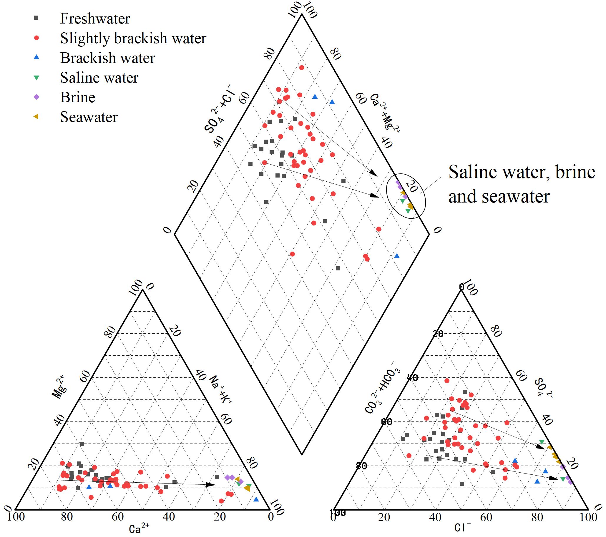
Figure 6. Piper diagram of water bodies in the study area.
3.3.2 Gibbs diagram
The Gibbs diagram reflects the control of major ion concentrations in water bodies via the effects of evaporation and concentration, rock weathering and leaching, and atmospheric precipitation. It plots the ratios of Na+/(Na++Ca2+) and Cl-/(Cl-+HCO3-) versus TDS (Gibbs, 1970).
The water chemistry data for seawater, brine, saline water, brackish water, slightly brackish water, and freshwater were plotted using the Gibbs diagram. The TDS values for the water bodies ranged from 456 to 83,584 mg/L, the cation ratios ranged from 0.08 to 0.96, and the anion ratios ranged from 0.25 to 0.99. The vast majority of the samples fell within the Gibbs diagram. The brine, seawater, and saline water bodies were more affected by evaporation and concentration, which had a stronger effect on brine than seawater and saline water (Figure 7). From the anion ratio, the evaporation-concentration effect gradually strengthened from freshwater → slightly brackish water → brackish water → saline water → seawater (brine), and from the cation ratio, freshwater and slightly brackish water bodies are obviously controlled by rock weathering dissolution and filtration, and part of the saline water bodies are also obviously controlled by rock weathering dissolution and filtration. The freshwater, slightly brackish water, and brackish water bodies in the study area were controlled by evapotranspiration-concentration and rock weathering leaching. In contrast, seawater, saline water, and brine were primarily controlled by evapotranspiration-concentration. All water bodies were weakly affected by precipitation, which is presumably related to the greater evaporation than precipitation in Laizhou City in recent years.
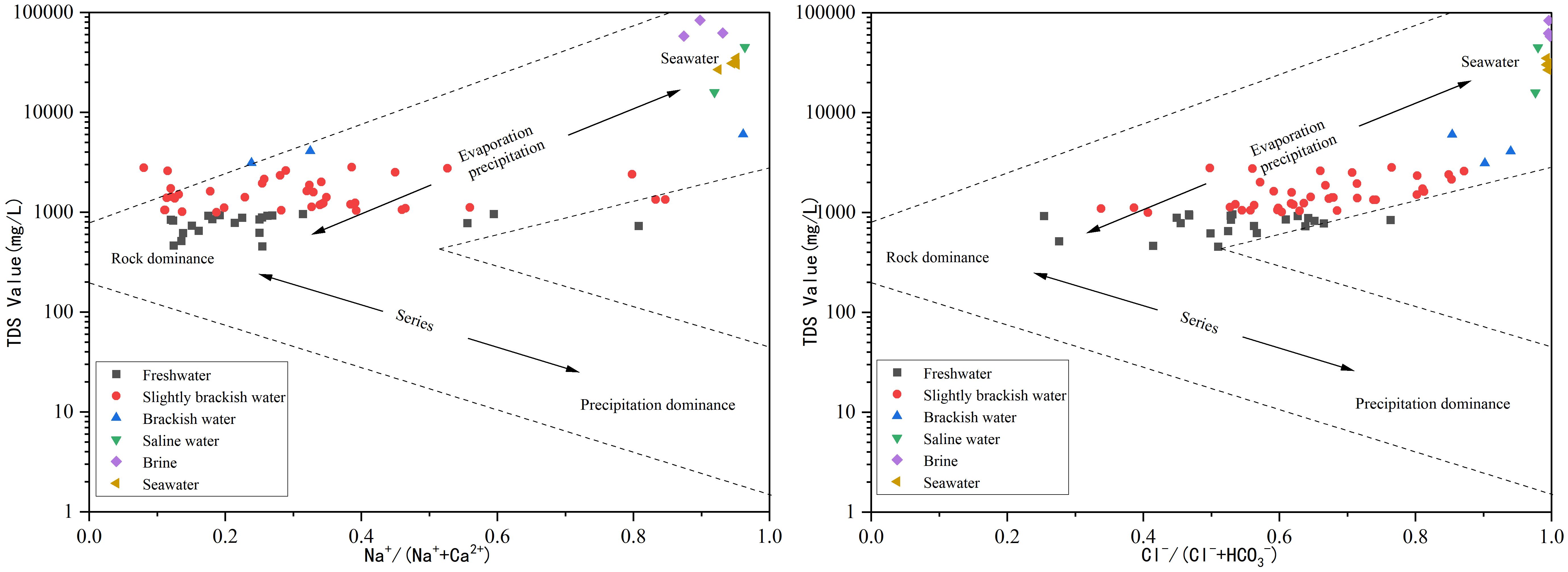
Figure 7. Gibbs diagram of groundwater and seawater in the study area.
3.3.3 Na+/Cl–Cl- relationships and Mg2+/Cl–Cl- relationships
The source of salts in groundwater can be elucidated using the Na+ and Cl- and Mg2+ and Cl- molar concentration ratios and Cl- mass concentration relationship (Hou et al., 2019). The Na+ and Cl- molar concentration ratio in seawater is 0.85, and the Na/Cl ratio of brine is < 0.85 (paleoseawater). However, the ratio is close to 1 or greater than 1 in dissolved filtration water and shallow freshwater (Wang et al., 1995).
Without human activities, rock salt dissolution is the main source of Na+ and Cl- in groundwater. The Na+/Cl–Cl- relationship revealed that two seawater samples were located on the line of the standard seawater ratio of 0.85, while the other three seawater samples had values of 0.94, 0.93, and 0.62. Seawater with ratios of 0.94 and 0.93 may have been affected by the input of land-based sources, which led to high Na+ content. For the seawater with a ratio of 0.62, the Na+ and Cl- contents were lower than those of the other seawater areas and may have been affected by rainwater or diluted by freshwater from land sources. The brine samples had ratios of 0.74, 0.76, and 0.7, which were lower than 0.85, and saline water had values of 1.02 and 0.96, which were slightly higher than 0.85. As the saline water sampling sites were located near the brine distribution area, the saline water was likely influenced by shallow freshwater infiltration, rainwater, or rock salt dissolution. Freshwater, slightly brackish water, and brackish water were predominantly below the 0.85 line. The Na+ content of these groundwater samples was low, while the Ca2+ content increased. The exchange of Na+ and Ca2+ in the groundwater likely occurred during the intrusion of the sea (salt) water. Among the sample sites, only four of the freshwater, four of the slightly brackish water, and one of the brackish water samples were distributed above the 0.85 line. which is ≥ 1. These samples were likely influenced by the general dissolved filtration water and shallow freshwater. Rock salt dissolution is also an important source of Na+ and Cl- for freshwater, slightly brackish water, and brackish water.
The distribution characteristics of water sample points in the Mg2+/Cl–Cl- relationship were more standardized. Mg, Na, and Cl were the primary components in standard seawater, and Mg and Cl were more strongly correlated (Mg/Cl value of 0.1). The seawater samples in this study were distributed on the line with a Mg/Cl value of 0.1, which is consistent with the Mg/Cl value of standard seawater, while the brackish, saline, and brine waters were all distributed along the standard seawater ratio line and close to the 0.1 line, which indicates that the ocean is an important source for brackish water, saline water, and brine formation (Edmunds et al., 2006; Yang et al., 2016). As some samples showed an obvious deviation of the Mg/Cl value from the 0.1 line, the influence of anthropogenic activities and other factors on the salt source could not be excluded based on an analysis of the sampling location and associated land uses. The Mg/Cl value of slightly brackish water began to increase, the Mg/Cl value of freshwater was the largest, and the Mg/Cl value gradually increased, indicating that the sea (salt) water intrusion was gradually decreasing. The salts gradually transitioned from the ocean as the primary source to other sources, such as the dissolution of rock salts and exogenous inputs due to anthropogenic activities.
3.3.4 (Na+ – Cl-) versus [(Ca2+ + Mg2+) – (HCO3- + SO42-)] relationship diagram
The (Na+ – Cl-) versus [(Ca2+ + Mg2+) – (HCO3- + SO42-)] relationship diagram provides an accurate indication of cation exchange, which is an ion-exchange reaction between clay minerals (e.g., montmorillonite and illite) in the aquifer and groundwater. If cation exchange plays an important role in groundwater evolution, then the relationship between (Na+ – Cl-) and [(Ca2+ + Mg2+) – (HCO3- + SO42-)] will exhibit a negative correlation with a slope of approximately -1 (McLean et al., 2000). Figure 8 shows that the slope of the fitted line for the groundwater samples in the study area was -0.9096, which is very close to -1, and the R2 value was 0.9616, indicating that cation exchange adsorption occurred in fresh, slightly brackish, and brackish waters in the study area.
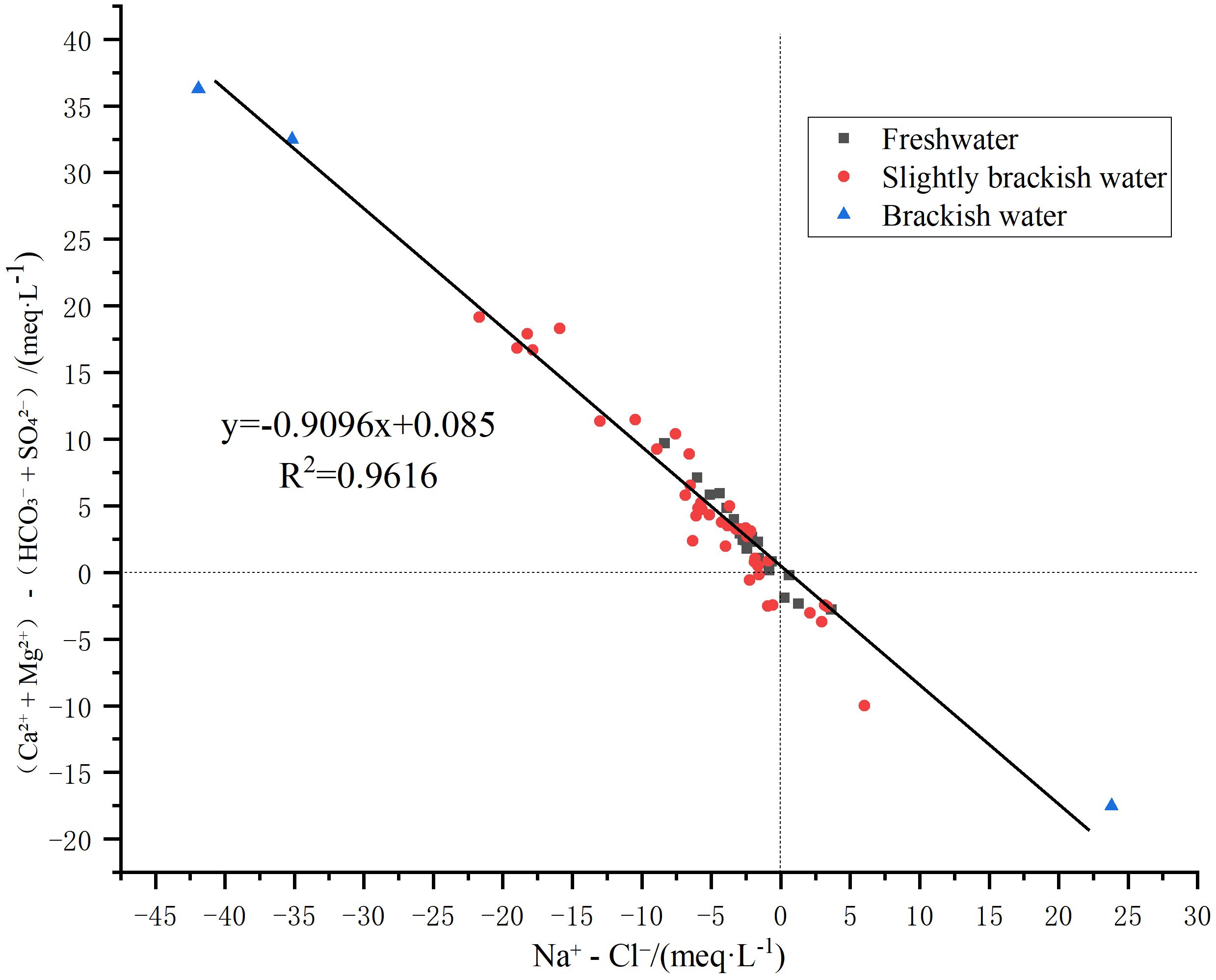
Figure 8. The (Na+ – Cl-) versus [(Ca2+ + Mg2+) – (HCO3- + SO42-)] relationship diagram.
Most of the samples exhibited Na+ < Cl-, with (Ca2++Mg2+) > (HCO3-+SO42-), which is a typical feature of seawater intrusion. Thus, during seawater intrusion, clay minerals adsorb Na+ and release Ca2+ and Mg2+. As the seawater intrusion increased, (Na+-Cl-) and [(Ca2+ + Mg2+) – (HCO3- + SO42-)] showed an increasing trend.
A few samples showed Na+ > Cl- and (Ca2++Mg2+) < (HCO3-+SO42-). These samples were all distributed in the coastal plain in the northern part of Laizhou City, and they showed high SO42- content, which may have been closely related to the high-intensity human activities in this area (e.g., agricultural fertilizer application, sewage discharge). Although granite is widely distributed in this area and silicate weathering releases Na+, most of the freshwater and slightly brackish water in the region showed Na+ < Cl-. Therefore, the high Na+ may have been caused by human activities rather than silicate weathering.
3.3.5 Mineral saturation index characterization
The saturation index (SI), which refers to the ratio of ionic activity for a particular mineral to its dissolution equilibrium capacity, can be used to characterize water-rock interactions in groundwater and compare the dissolution-precipitation reactions of minerals in aquifers (Han, 2023). In this study, the saturation indices of minerals such as anhydrite (CaSO4), aragonite (CaCO3), calcite (CaCO3), dolomite (CaCO3), gypsum (CaSO4·2H2O), and halite (NaCl) in the water bodies of the study area were calculated using PHREEQC software.
Figure 9 shows that the calcite, aragonite, and dolomite saturation indices exhibited the same fluctuation trends. Certain freshwater samples with little or no influence from seawater were saturated or supersaturated with calcite, aragonite, and dolomite, indicating that corresponding carbonate minerals occurred in the water-bearing medium of the study area and that mineral dissolution is an important source of Ca2+ in freshwaters. In addition, the saturation indices of calcite, aragonite and dolomite in most freshwater samples were lower than those in other water bodies and were not yet saturated, while the saturation indices of calcite, aragonite, and dolomite in slightly brackish and brackish waters samples were mostly close to 0 or even greater than 0. Combined with the observations from previous studies cited in this paper, cation-exchange adsorption was the main reason for the increased Ca2+ and Mg2+ contents in the slightly brackish and brackish water samples.

Figure 9. Mineral saturation index of different water bodies in the study area.
As the TDS increased, the saturation indices of gypsum, anhydrite, and halite showed an overall gradually increasing trend. Such a trend was also observed in the process of subsurface runoff. As the sampling location of this paper was located in a coastal plain area, which is less affected by the effect of runoff, this increasing trend was mainly caused by the intrusion of sea (salt) water. In addition, from freshwater to brine, the saturation index of gypsum and anhydrite gradually tended to 0 or even greater than 0, indicating that each mineral gradually tended to be saturated or even reached supersaturation in this process. This finding explains the large number of gypsum crystals in the brine resource area observed over the course of the field investigation. In addition to seawater and brine, gypsum, anhydrite, and halite in the water body had not reached a saturated state and only showed the effect of sea (salt) water intrusion, which indicates that certain evaporite minerals were not found or were only found at low levels in the local aquifer.
3.3.6 Analysis of the mixing processes of freshwater and seawater
During seawater intrusion, Cl- is usually considered a conserved ion and thus can be used to calculate the seawater-freshwater mixing ratio. In addition, the concentration of different ions can be compared with the theoretical concentration to calculate the ion delta value (the measured concentration of ions in the water samples minus the concentration of ions in the theoretical mixing solution) to determine the enrichment effect of ions (Yao et al., 2011).
Figure 10 shows that the proportion of sea (salt) water intrusion increased, the TDS in the water body gradually increased, Ca2+ and Mg2+ increased, and Na+ decreased in most of the slightly brackish and brackish water. The increasing trend of Ca2+ was noticeable because calcite, aragonite, and dolomite were close to saturation or supersaturation in the slightly brackish and brackish water. Therefore, cation alternating adsorption was the main reason for the increase in Ca2+ and Mg2+ and the decrease in Na+.

Figure 10. Ionic delta values of Na+, Ca2+, Mg2+ and K+ in different water bodies.
When the TDS was low, Ca2+ was not significantly enriched in freshwater, indicating that mineral dissolution was the main source of groundwater salinity. As the proportion of sea (salt) water intrusion increased, TDS gradually increased and the groundwater began to receive salts from seawater or brine sources. Moreover, the samples were significantly affected by the cation alternating adsorption effect. In addition, some of the water bodies showed high Na+ enrichment, which may have been closely related to the high-intensity human activities in the study area.
3.4 Overview of the causes and trends of sea (salt) water intrusion
3.4.1 Groundwater recharge and discharge
The terrain of Laizhou City is high in the south and low in the north, with low mountains and hills accounting for 58.3% of the area and plains accounting for 41.6% (Guo et al., 2021). The overall trend of the groundwater level from the land to the sea constantly decreases, with groundwater discharge to the sea representing the main mode. Except for the Jiao Lai River, all other rivers originate from the southeast, have short channels and steep longitudinal slopes, and are seasonal rain-fed rivers, with most of their annual precipitation concentrated in the months of June–August, which accounts for 85.6% of the average multi-year rainfall. Except for a small amount of precipitation retained by reservoirs and dams during the flood season, a large amount of precipitation is discharged into the sea through confluence, with minimal recharge to groundwater (Guo et al., 2021). Once the flood season ends, most rivers dry up again without water.
The area is arid, experiences low levels of rain, and has many irrigation wells. Seasonal irrigation and mining are the main discharge modes in the freshwater area. In the brine resource area around Tushan Town and the seawater aquaculture area in Jincang Street, groundwater is primarily used for brine mining and seawater aquaculture, and groundwater pumping is the main mode of discharge in this area. Many villages and towns in Laizhou City are underground mining areas, and some mines are as deep as 800 m. The large amount of pumped groundwater has caused the groundwater level of shallow strata to drop dramatically (Guo et al., 2021), and coupled with the uncontrolled mining in villages and towns, the overall decline in the groundwater level of Laizhou City is serious, and the groundwater cannot be recharged and replenished efficiently. In addition, the Wanghe Underground Reservoir in the north of Laizhou City, built in 2004, has greatly prevented seawater intrusion. In recent years, the massive exploitation of bedrock fissure water in the reservoir's northern part has weakened the underground reservoir's role. The salty groundwater has intruded into the inland areas along the bedrock fissure.
Long-term observation of groundwater dynamics revealed a gradual downward trend in groundwater in the whole region. A significant groundwater descent funnel exists in Tushan Town in the southwestern part of Laizhou City, which is related to the long-term exploitation of underground brine in the local area. A descent funnel exists in the southwestern seashore of Jincang Street in the northern part of Laizhou City, due to seawater aquaculture; the aquaculture activities in the area result in the convergence of the surrounding groundwater to the seashore, so that seawater cannot be intruded from the west side, but this has increased the risk of seawater intrusion from the north side to the south.
3.4.2 Causes of intrusion
The causes of sea (salt) water intrusion in Laizhou City are complex. Studies (Yin et al., 1992; Wu et al., 1994; Wang et al., 2008) have shown that natural factors, such as meteorology, hydrology, geological topography, and storm surges are the basic conditions for the occurrence and development of intrusions. Irrational economic activities, such as over-exploitation of groundwater, are the primary factors leading to the occurrence and development of seawater intrusions. In terms of geological factors, the intrusion of sea (salt) water into Laizhou City is closely related to the stratigraphy of the Quaternary System and bedrock fissures. The coastal plain of Laizhou City consists of alluvial and floodplain strata, with thick sand layers, coarse grains, and good water permeability; the development of basal fracture structures is vertically intersected with the coastline in a northwesterly direction, which is well connected with seawater (Yin et al., 1992). Seawater can easily intrude into the land once the balance between the underground freshwater and the seawater pressure is lost.
Regarding storm surge factors, the coastal area of Laizhou City is a storm surge-prone area. Storm surges occur many times a year (Li, 2011), flooding farmland and washing down houses in the coastal area. Seawater become stagnant when it pools for a long time on the land, thus creating favorable conditions for seawater intrusion. Laizhou City is also affected by a monsoon climate that is relatively dry and produces less rain, which is the main natural factor causing seawater intrusion in Laizhou City. Over the past 10 years, low rainfall levels have been observed in Laizhou City, and evaporation has exceeded rainfall, thus reflecting the continuous dry climate. Runoff of surface water and groundwater into the sea is consequently reduced or disappears, and the dynamic balance between salty and fresh water in the aquifers is disrupted, thereby intensifying seawater intrusion in the area.
With respect to sea level rise, the rate along the coast of China was 3.4 mm/year from 1980 to 2020, which was higher than the global rate during the same period (Ministry of Natural Resources of the People's Republic of China, 2021). In 2020, the sea level along the coast of the Bohai Sea was 86 mm higher than that in a typical year and 12 mm higher than that in 2019 (Ministry of Natural Resources of the People's Republic of China, 2021). As the sea level rises, the tidal influence increases and seawater invades the rivers, increasing the salinity of these freshwater bodies. This affects industrial and agricultural and residential water use along the rivers. The rise in sea level also disrupts the pressure balance between salty and fresh water, which causes seawater to flow into the land from the lateral direction, leading to the salinization of the soil or even the pollution of underground freshwater resources.
In terms of man-made factors, in 1977, there was a continuous drought in Jiaodong Peninsula, and all the water storage projects within the city were dried up. Consequently, the rivers were cut off, affecting the production of industry and agriculture that relied on groundwater extraction. In the coastal plain area, to increase food production, there is a climax of drilling wells and excessive groundwater exploitation. In a relatively short period, the density of machine wells and large wells in the plain areas to the south and north of Laizhou City reached more than 10 wells/km2 (Li, 2011), and 20–25 wells/km2 in some townships (Wang et al., 2008). This has led to serious over-exploitation of the groundwater and negative funneling in some areas, inducing seawater intrusion.
In addition, the expansion of salt fields in Laizhou and seafood cultivation on land have introduced seawater into the land, which is also an anthropogenic factor of seawater intrusion that cannot be ignored (Wang et al., 2008). In recent years, the northern part of Laizhou City has been exploiting bedrock fissure water for agricultural irrigation; the balance of salty and fresh water in the deep part of the city has been disrupted, resulting in the direct intrusion of sea (salt) water into the inland hinterland along the bedrock fissure, and the special phenomenon of high chlorine value in the inland hinterland.
3.4.3 Sea (salt) water intrusion trends
Since the occurrence of seawater intrusion in 1976, the seawater intrusion disaster has gone through five developmental stages, including initial development, deterioration, mitigation, and differentiation (Zhuang et al., 1999; Feng et al., 2006; Yi et al., 2010; Liu et al., 2011; Miao, 2013; Cheng et al., 2016). When the initial seawater intrusion was identified, only 15.81 km2 of seawater had intruded in Laizhou City, mainly in areas with a high density of well-drilling and high groundwater extraction. The area of intrusion reached 273 km2 in 1995, 276.99 km2 in 1997, 259.67 km2 in 1999, 234 km2 in 2003, 261 km2 in 2005, and 257 km2 in 2008, with 1997 presenting the peak of seawater intrusion before 2008 (Wang et al., 2008; Liu et al., 2011). Turbot culture was introduced in 1996, and the scale of culture has since expanded rapidly along with the large extraction of brackish groundwater (600,000~700,000 m3/day), reducing the groundwater level in the brackish water area. Furthermore, saline and freshwater interfaces have continued to move to the brackish side and eventually remained stable (Zhao et al., 2017), and the area of seawater intrusion declined from 273 km2 in 1995 to 234 km2 in 2003, a decrease of 14.2% compared with the peak (Cheng et al., 2016). In 2007, the intrusion area expanded again to 241 km2, and in 2010, the seawater intrusion area in Laizhou City was 232 km2. While the intrusion area fluctuated, it remained stable (Miao et al., 2013). According to the statistics presented in this study, the area of seawater intrusion in 2020 reached 645.76 km2 (including 151.64 km2 of severe intrusion area), which is the highest level recorded, indicating that seawater intrusion has rapidly increased since 2010.
From 1976 to 1997, there was a period of rapid intrusion; from 1997 to 2003, there was a period of weak intrusion; from 2003 to 2010, the intrusion was relative stability; and from 2010 to 2020, there was a period of rapid intrusion. Historical data indicate that the climate of Laizhou City will remain predominantly dry in the coming years; thus, seawater intrusion is expected to intensify.
3.5 Groundwater evolution and intrusion patterns
The above analyses revealed the groundwater evolution characteristics based on the ion content and characteristic ion ratios in different water bodies. Combined with the factors that affect seawater intrusion, the ion content and ratios reveal the groundwater evolution and seawater intrusion patterns in the study area (Figure 11).
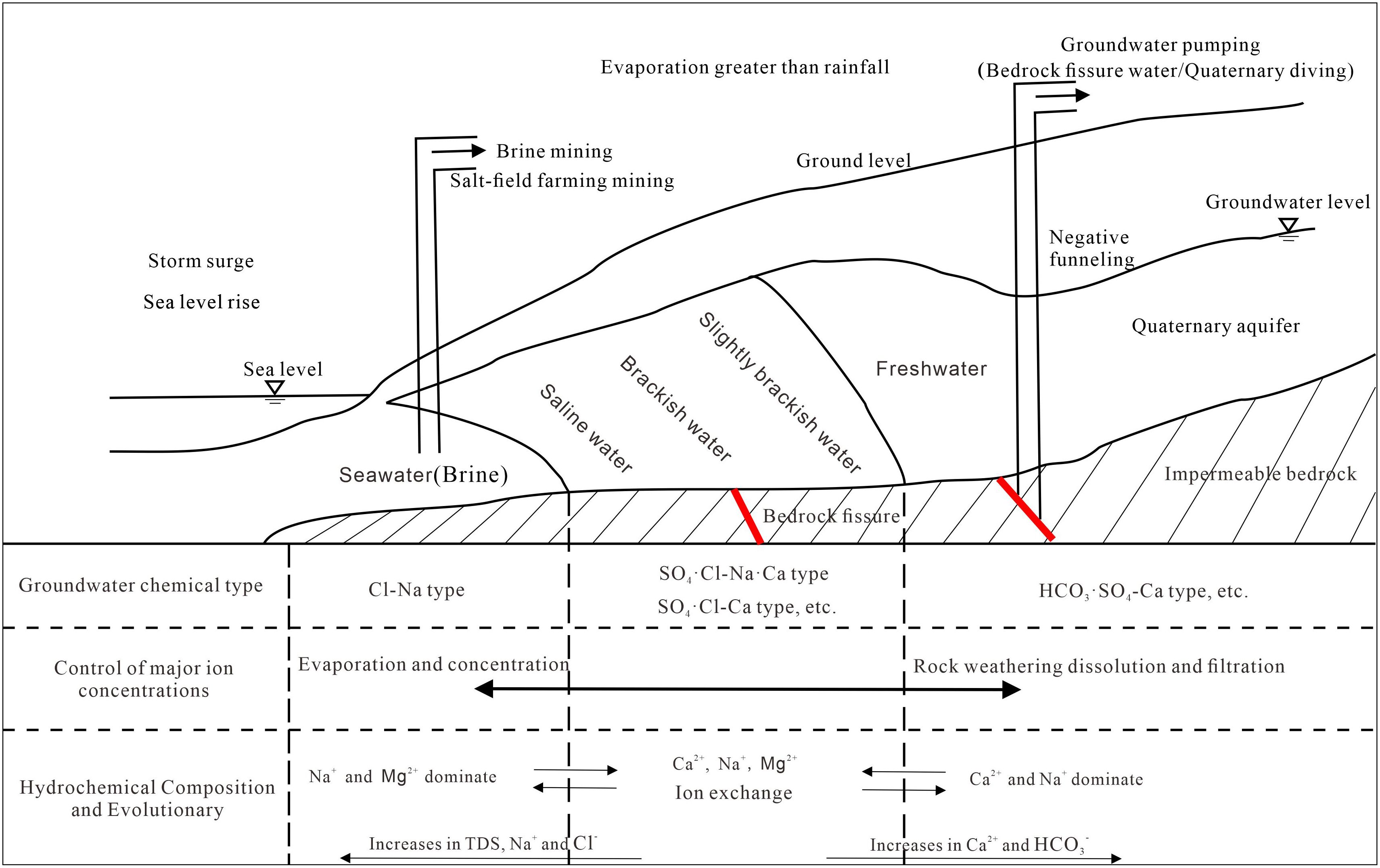
Figure 11. Sketch map of groundwater evolution and intrusion patterns in the study area.
From land to sea, the pre-mountain plains and alluvial plains area present a large slope, high accumulations of alluvial deposits with coarse sediment particles, strong aquifer development, good groundwater recharge and drainage circulation conditions, and steep groundwater hydraulic gradients (Li, 2005). The hydrochemical type is expressed as HCO3·SO4-Ca type, which led to the formation of freshwater with low mineral content. The area extending to the alluvial plain and marine plain zone of the near-shore zone exhibits finer sediments due to the sorting effect, a lower gradient of underground runoff, increased vertical discharge (from evaporation and groundwater mining), and more saline groundwater. This zone not only receives inland underground freshwater recharge but also experiences seawater intrusion and water-rock ion exchange. In this process, ions such as Ca and Mg increased and Na ions decreased. The water chemistry type evolved into the SO4·Cl-Na·Ca type and SO4·Cl-Ca type, thus forming a mixed type of freshwater and seawater. In the seawater of Laizhou Bay, the hydrochemical type evolved into the Cl-Na type. In the coastal plain area in the southwestern part of the study area, groundwater runoff and circulation were slow, vertical evaporation was significantly enhanced and represented the main discharge pathway over geological history. In addition, the TDS increased. Thus, this area formed a typical brine resource distribution area, and the groundwater chemistry type evolved to the Cl-Na type.
Groundwater has been over-exploited in the plain area of Laizhou City for many years, which has destroyed the balance of salt and fresh water. Under the background of higher groundwater discharge than recharge and the combined effect of various factors, such as sea level rise and storm surge, sea (salt) water has gradually intruded to inland areas and a unique intrusion pattern has formed (Figure 11).
4 Conclusions
In this study, freshwater, slightly brackish water, brackish water, saline water, brine, and seawater samples were obtained from the coastal area of Laizhou City. These samples were analyzed to generate an overall picture of the hydrochemical characteristics of the groundwater in the study area, calculate the area of the most recent sea (salt) water intrusion, determine the evolutionary trends of hydrochemical constituents from freshwater to sea (brine) water, and perform superficial analyses of the mechanisms and trends of intrusion. The research results are of great practical significance for the graded management of groundwater in Laizhou City. The following conclusions were obtained:
1. From the land to the sea, seawater and brine gradually affect groundwater in Laizhou City. Furthermore, the Cl- and Na+ contents have gradually increased, and groundwater has gradually transitioned from an HCO3·SO4·Cl-Ca type to SO4·Cl-Na·Ca, SO4·Cl-Ca, and Cl-Na types.
2. Evapotranspiration-concentration and rock weathering leaching processes control the freshwater, slightly brackish, and brackish water bodies in the study area. In contrast, the evapotranspiration-concentration process primarily controls saline and brine waters.
3. When the TDS is low, mineral dissolution is the main source of groundwater salinity. As the proportion of sea (salt) water intrusion increases, the TDS gradually increases and the groundwater begins to receive salts from seawater or brine. In addition, the groundwater is significantly affected by the cation alternating adsorption effect. Part of the water body shows a high degree of enrichment of Na+ and SO42-, which may be closely related to the high-intensity human activities in the study area.
4. The Laizhou City sea (salt) water intrusion area was significant and widespread, with a strip-like distribution. In 2020, the sea (salt) water intrusion area in Laizhou City was 645.76 km2. Over time, groundwater in Laizhou City has been heavily exploited and insufficiently recharged. Under the influence of natural factors such as meteorology, geological topography, and storm surges, the balance between salty and fresh water has been disrupted, leading to the intrusion of sea (salt) water into the inland and a unique intrusion pattern. Based on historical data, the intrusion of sea (salt) water is expected to continue over the next few years.
Data availability statement
The original contributions presented in the study are included in the article/supplementary material. Further inquiries can be directed to the corresponding author.
Author contributions
LK: Writing – original draft, Writing – review & editing. HC: Project administration, Writing – original draft. GH: Conceptualization, Methodology, Writing – review & editing. JZ: Data curation, Software, Writing – original draft. LZ: Investigation, Writing – original draft. XH: Investigation, Validation, Writing – original draft. YL: Software, Visualization, Writing – original draft. FZ: Investigation, Writing – original draft. MY: Conceptualization, Supervision, Writing – review & editing. XZ: Data curation, Software, Writing – review & editing.
Funding
The author(s) declare that financial support was received for the research and/or publication of this article. This study was supported by Open Research Fund of Observation and Research Station of Seawater Intrusion and Soil Salinization, Laizhou Bay, Ministry of Natural Resources(2024LZORS003) and the Geological Survey Programs of the People's Republic of China (DD20243124, ZD20220220).
Conflict of interest
The authors declare that the research was conducted in the absence of any commercial or financial relationships that could be construed as a potential conflict of interest.
Generative AI statement
The author(s) declare that no Generative AI was used in the creation of this manuscript.
Publisher’s note
All claims expressed in this article are solely those of the authors and do not necessarily represent those of their affiliated organizations, or those of the publisher, the editors and the reviewers. Any product that may be evaluated in this article, or claim that may be made by its manufacturer, is not guaranteed or endorsed by the publisher.
References
Abu-alnaeem M., Yusoff I., Ng T., Alias Y., and Raksmey M. (2018). Assessment of groundwater salinity and quality in Gaza coastal aquifer, Gaza Strip, Palestine: An integrated statistical, geostatistical and hydrogeochemical approaches study. Sci. Total Environ. 615, 972–989. doi: 10.1016/j.scitotenv.2017.09.320
Arroyo-Figueroa C., Chalá D., Gutiérrez-Ribon G., and Quiñones-Bolaños E. (2024). A framework to evaluate groundwater quality and the relationship between rock weathering and groundwater hydrogeochemistry in the tropical zone: A case study of coastal aquifer arroyo Grande, in the Caribbean region of Colombia. Water. 16, 1650. doi: 10.3390/w16121650
Balasubramanian M., Sridhar S., Ayyamperumal R., Karuppannan S., Gopalakrishnan G., Chakraborty M., et al. (2022). Isotopic signatures, hydrochemical and multivariate statistical analysis of seawater intrusion in the coastal aquifers of Chennai and Tiruvallur District, Tamil Nadu, India. Mar. Pollut. Bull. 174, 113232. doi: 10.1016/j.marpolbul.2021.113232
Chang Q., Gao C., Zheng X., Lin Y., and Song X. (2024). A novel subsurface adjustable dam for preventing active seawater intrusion in coastal aquifers. Front. Mar. Sci. 11. doi: 10.3389/fmars.2024.1412052
Chen G. (2010). Risk assessment of seawater intrusion disaster in the Laizhou Bay based on GIS. Qingdao, Shandong Province, China: Ocean University of China.
Chen G. (2013). Mechanisms underlying of seawater intrusion and evaluation of early warning systems in the Laizhou Bay area. Shanghai, China: East China Normal University.
Chen B., Li Q., Wang Z., Zhang H., Li W., Cheng J., et al. (2024). Analysis on the change trend and influencing factors of seawater intrusion in Shenzhen from 2017 to 2022. Marine Geology Frontiers. 40, 55–64. doi: 10.16028/j.1009-2722.2023.003
Chen Y., Xu Y., Chen G., Zeng M., Zhang T., Zhang X., et al. (2024). Analysis of influencing factors of seawater intrusion in the Yangtze River Estuary and control for water supply security. Front. Mar. Sci. 11. doi: 10.3389/fmars.2024.1413548
Cheng S., Dai W., and Luo W. (2016). Practice and experience of seawater intrusion control in Laizhou City. Shandong Water Resources. 18, 32–33. doi: 10.16114/j.cnki.sdsl.2016.03.016
Cui Z., Chen G., Chen S., Yu H., Chen K., Ran B., et al. (2024). Groundwater salinization under the influence of paleo sea-level fluctuation: a case study in southern Laizhou Bay, China. Front. Mar. 10. doi: 10.3389/fmars.2023.1302064
Dong J., Zeng X., and Wu J. (2018). Advances in numerical simulation of seawater intrusion in different coastal zone. Geological J. China Universities. 24, 442–449. doi: 10.16108/j.issn1006-7493.2017120
Edmunds W., Ma J., Aeschbach-Hertig W., Kipfer R., and Darbyshire D. (2006). Groundwater recharge history and hydrogeochemical evolution in the Minqin Basin, North West China. Appl. Geochem. 21, 2148–2170. doi: 10.1016/j.apgeochem.2006.07.016
Feng A., Gu D., and Xia D. (2006). Developments and causes of seawater intrusion in the south coast area of the Laizhou Bay. Coastal Engineering. 25, 7–13.
Gao M., Guo F., Hou G., Qiu J., Kong X., Liu S., et al. (2018). The evolution of sedimentary environment since late Pleistocene in Laizhou Bay, Bohai Sea. Geology China. 45, 59–68.
Gibbs R. (1970). Mechanisms controlling world water chemistry. Science. 170, 1088–1090. doi: 10.1126/science.170.3962.1088
Guo Z., Pan J., and Li N. (2021). Survey on groundwater status problems and countermeasures in Laizhou City. Water Resour. Tech. Supervision. 6, 68–69.
Han X. (2023). Study on chemical characteristics of groundwater andseawater intrusion in northern Laizhou City. China University of Geosciences, Beijing.
Han D., Kohfahl C., Song X., Xiao G., and Yang J. (2011). Geochemical and isotopic evidence for palaeo-seawater intrusion into the south coast aquifer of Laizhou Bay, China. Appl. Geochem. 26, 863–883. doi: 10.1016/j.apgeochem.2011.02.007
Han D., Song X., Currell M., Yang J., and Xiao G. (2014). Chemical and isotopic constraints on evolution of groundwater salinization in the coastal plain aquifer of Laizhou Bay, China. J. Hydrol. 508, 12–27. doi: 10.1016/j.jhydrol.2013.10.040
He Z., Ma C., Zhou A., Qi H., Liu C., Cai H., et al. (2018). Using hydrochemical and stable isotopic (δ2H,δ18O,δ11B, and δ37Cl) data to understand groundwater evolution in an unconsolidated aquifer system in the southern coastal area of Laizhou Bay, China. Appl. Geochem. 90, 129–141. doi: 10.1016/j.apgeochem.2018.01.003
Hou G., Gao M., and Dang X. (2019). Hydrochemical characteristics and salinization causes of shallow groundwater in Caofeidian, Tangshan City. Earth Sci. Front. 26, 049–057. doi: 10.13745/j.esf.sf.2019.8.10
Huang P., Ma C., and Zhou A. (2023). Unraveling the complexities of groundwater salinization in coastal environments: insights from Laizhou Bay’s Eastern Coast, China. Water. 15, 3629. doi: 10.3390/w15203629
Kim R., Kim J., Ryu J., and Koh D. (2019). Hydrogeochemical characteristics of groundwater influenced by reclamation, seawater intrusion, and land use in the coastal area of Yeonggwang, Korea. Geosci. J. 23, 603–619. doi: 10.1007/s12303-018-0065-5
Li F. (2005). Monitoring and Numerical Simulation of Saltwater Intrusion in the Eastern Coast of Laizhou Bay, China. Ocean University of China.
Li Y. (2011). Study on analysis and prevention of seawater intrusion in Laizhou. Ground Water. 33, 70–72. doi: 10.1111/j.1745-6592.2011.01350.x
Li B., Hu S., and Zhao Q. (2020). Chemical characteristics of groundwater in coastal seawater intrusion area of Laizhou Bay. Glob. Geol. 39, 971–977.
Li X. and Ye S. (2016). Progress in seawater intrusion. Mar. Geol. Quat. Geol. 36, 211–217. doi: 10.16562/j.cnki.0256-1492.2016.06.023
Liu H., Gao L., Ma C., and Yuan Y. (2023). Analysis of the seawater intrusion process based on multiple monitoring methods: study in the southern coastal plain of Laizhou Bay, China. Water. 15, 2013. doi: 10.3390/w15112013
Liu D., Ji S., and Zhou X. (2011). Prevention and effect analysis of seawater intrusion in Laizhou. Shandong Water Resources. 1, 34–35. doi: 10.16114/j.cnki.sdsl.2011.01.002
Lu X., Zhou A., Wang M., Yang L., and Lu H. (2010). Characteristic analysis of phreatic water equality evolution by Piper diagram in Huaihe River drainage area, Jiangsu Province. Geotechnical Invest. Surveying. 38, 42–47.
McLean W., Jankowski J., and Lavitt N. (2000). “Groundwater quality and sustainability in an alluvial aquifer, Australia,” in Proceedings of the XXXth International-Association-of-Hydrogeolgists Congress on Groundwater, Past Achievements and Future Challenges. Cape Town South Africa 26th November-1st December 2000. A. A. Balkema, Rotterdam, Brookfield.
Meyer R., Engesgaard P., and Sonnenborg T. (2019). Origin and dynamics of saltwater intrusion in a regional aquifer: Combining 3-D saltwater modeling with geophysical and geochemical data. Water Resour. Res. 55, 1792–1813. doi: 10.1029/2018WR023624
Miao Q. (2013). Effects of precipitation and tide on seawater intrusion in the Laizhou Bay. First Institute of Oceanography, State Oceanic Administration.
Miao Q., Chen G., Liu W., Xu X., Su Q., and Yu H. (2013). Disaster evolution and genesis of seawater intrusion in the Laizhou Bay. Coast. Eng. 32, 69–78.
Ministry of Natural Resources of the People's Republic of China. Technical specification for monitoring and evaluation of seawater intrusion: HY/T 0314—2021.
Ministry of Natural Resources of the People's Republic of China (2021). 2020 China marine disaster bulletin.
Moorthy P., Sundaramoorthy S., Roy P., Usha T., Dash S., Gowrappan M., et al. (2024). Evaluation of spatial and temporal dynamics of seawater intrusion in coastal aquifers of southeast India: insights from hydrochemical facies analysis. Environ. Monit Assess. 196, 179. doi: 10.1007/s10661-024-12306-w
Okofo L., Bedu-Addo K., and Martienssen M. (2022). Characterization of groundwater in the 'tamnean' plutonic suite aquifers using hydrogeochemical and multivariate statistical evidence: A study in the garu-tempane district, upper east region of Ghana. Appl. Water Sci. 12, 22. doi: 10.1007/s13201-021-01559-2
Salem Z., ElNahrawy A., Attiah A., and Edokpayi J. (2022). Vertical and spatial evaluation of the groundwater chemistry in the Central Nile Delta Quaternary aquifer to assess the effects of human activities and seawater intrusion. Front. Environ. Sci. 10, 961059. doi: 10.3389/fenvs.2022.961059
Sallam O. (2022). New approach in estimation of seawater intrusion footprint (SWIF) for irrigated crops using coastal groundwater. Groundw. Sustain. Dev. 18, 100772. doi: 10.1016/j.gsd.2022.100772
Samanta A., Chatterjee T., Mandal P., Chatterjee A., Jha M., and Singh M. (2024). Modeling saltwater intrusion into groundwater using a prey–predator model. J. Hydrologic Engineering. 29, 04024021. doi: 10.1061/JHYEFF.HEENG-6071
Sun X., Xu J., Yang Q., Shi P., Zhong X., Zhang S., et al. (2006). Character and prevention strategies of sea (Saline) water invasion in circum-bohai-sea region. Geol. Surv. Res. 29, 203–210.
Tang X., Wang H., Zuo F., and Danian B. (2007). Numerical simulation of fresh-saline water interface interactive regularities in coastal areas due to the tidal fluctuation. J. Saf. Environ. 7, 84–92.
Walraevens K., Bakundukize C., Mtoni Y., and Van C. (2018). Understanding the hydrogeochemical evolution of groundwater in precambrian basement aquifers: A case study of bugesera region in Burundi. J. Geochem. Explor. 188, 24–42. doi: 10.1016/j.gexplo.2018.01.003
Wan L., Ma Z., Wang W., Wang Y., Shi J., Tian T., et al. (2012). Hydrogeological Handbook. 2nd ed. (Beijing: Geological Publishing House), 93–98.
Wang W., Cheng X., Gao X., Tian Z., Liu C., Wu Z., et al. (2023). The genesis of groundwater chemistry in yellow river delta - A case study of gudao town, Dongying City, Shandong Province. Earth Sci. Front. 32 (02), 469-483. doi: 10.13745/j.esf.sf.2023.12.30
Wang J., Guo Z., Tian Y., Fan L., Zeng W., Wang X., et al. (2022). Development and application of sea water intrusion models. Hydrogeol. Eng. Geol. 49, 184–194. doi: 10.16030/j.cnki.issn.1000-3665.202105037
Wang C., Wang Y., Fu Y., Wu Y., Yu J., Li Q., et al. (2014). Study of seawater invasion distribution and the groundwater hydro-chemical feature along the coast area of Liaodong Bay. J. Institute Disaster Prev. 16, 25–31.
Wang P., Wang B., and Liu D. (2008). Exploration of seawater intrusion in Laizhou City and its prevention and control measures. Shandong Water Resources. 11, 60–61. doi: 10.16114/j.cnki.sdsl.2008.11.002
Wang D., Zhang R., and Shi Y. (1995). Fundamentals of Hydrogeology (Beijing: Geological Publishing House), 50–81.
Wu J., Xue Y., and Liu P. (1994). Development and hydrochemical characteristic of seawater intrusion in Longkou-Laizhou District. J. Nanjing Univ. (Natural Sci. Edition). 30, 98–110. doi: 10.19762/j.cnki.dizhixuebao.2011.01.010
Wu J., Xue Y., Xie C., and Zhang Z. (1996). The cation exchange between water-rock interaction in the process of seawater intrusion. Hydrogeol. Eng. Geol. 23, 18–19.
Xaza A., Mapoma H., Abiye T., Clarke S., and Kanyerere T. (2023). Investigating seawater intrusion in republic of South Africa’s heuningnes, cape agulhas using hydrogeochemistry and seawater fraction techniques. Water. 15, 2141. doi: 10.3390/w15112141
Yang Q., Wang R., Xu S., Li W., Wang Z., Mei J., et al. (2016). Hydrogeochemistry and stable isotopes of groundwater from Shouguang, Laizhou and Longkou in the south coast aquifer of Laizhou Bay. Acta Geolog. Sin. 90, 801–817.
Yao J., Zhou X., and Xie C. (2011). On the geochemical processes of seawater intrusion in theWestern section of the haicheng district of Beihai, Guangxi. Acta Geologica Sinaca. 85, 136–143.
Yi H., Zhang P., Bi J., Zhong S., Xia Y., and Yu J. (2010). The influence of seawater intrusion on ecological environment in the eastern coast of Laizhou Bay. Mar. Sci. 34, 29–34.
Yin Z., Geng S., Zou B., Lin W., Cai Z., Yang M., et al. (1992). Seawater intrusion research in coastal area of Laizhou (Beijing: China Ocean Press), 43–59.
Yusuf M., Abiye T., Ibrahim K., and Abubakar H. (2021). Hydrogeochemical and salinity appraisal of surficial lens of freshwater aquifer along Lagos coastal belt, South West, Nigeria. Heliyon. 7, e08231. doi: 10.1016/j.heliyon.2021.e08231
Zhang Z. (2004). Research on the Seawater Incursion Control and Treatment for the City of Laizhou the Wanghe River Down Stream Region. Ocean University of China.
Zhang Y., Li H., Zhao Q., Jia J., and Wang H. (2024). Hydrogeochemical characteristics of typical seawater intrusion in Xingcheng City. Mar. Geol. Front. 40, 32–41. doi: 10.16028/j.1009-2722.2023.291
Zhang B., Zhao D., Zhou P., Qu S., Liao F., and Wang G. (2020). Hydrochemical characteristics of groundwater and dominant water–rock interactions in the delingha area, qaidam basin, northwest China. Water 12, 836. doi: 10.3390/w12030836
Zhao J. (1998). Hydrochemical indexes of seawater intrusion and comprehensive judgement on intrusive degree. Sci. Geogr. Sin. 18, 21–29.
Zhao J., Deng Y., Xu Y., and Yu L. (2017). Development trend analysis of seawater intrusion in Laizhou from 2011 to 2016. Mar. Sci. 41, 136–142.
Zhou X. (2013). Basic characteristics and resource classification of subsurface brines in deep-seated aquifers. Hydrogeol. Eng. Geol. 40, 4–10. doi: 10.16030/j.cnki.issn.1000-3665.2013.05.002
Keywords: sea (salt) water intrusion, hydrochemical composition, hydrochemical evolution, intrusion mechanism, Laizhou City
Citation: Kong L, Chu H, Hou G, Zeng J, Zhao L, Han X, Li Y, Zhou F, Yin M and Zhang X (2025) Characteristics and mechanisms of sea (salt) water intrusion in Laizhou City, Shandong Province, China. Front. Mar. Sci. 12:1578175. doi: 10.3389/fmars.2025.1578175
Received: 17 February 2025; Accepted: 19 May 2025;
Published: 06 June 2025.
Edited by:
Xinchen Gu, China Institute of Water Resources and Hydropower Research, ChinaReviewed by:
Tengfei Fu, Ministry of Natural Resources, ChinaAnimesh Samanta, The Neotia University, India
Copyright © 2025 Kong, Chu, Hou, Zeng, Zhao, Han, Li, Zhou, Yin and Zhang. This is an open-access article distributed under the terms of the Creative Commons Attribution License (CC BY). The use, distribution or reproduction in other forums is permitted, provided the original author(s) and the copyright owner(s) are credited and that the original publication in this journal is cited, in accordance with accepted academic practice. No use, distribution or reproduction is permitted which does not comply with these terms.
*Correspondence: Xuzhen Zhang, enh6MDM4MUAxNjMuY29t