 Bogdan Prodanov1*
 Chavdar Gussev2
 Desislava Sopotlieva2
 Magdalena Valcheva2
 Radoslava Bekova1
 Ahinora Baltakova3
 Rosen Tzonev3
 Julian Popov4
- 1Institute of Oceanology, Bulgarian Academy of Sciences, Varna, Bulgaria
- 2Institute of Biodiversity and Ecosystem Research, Bulgarian Academy of Sciences, Sofia, Bulgaria
- 3Faculty of Geology and Geography, Sofia University “St. Kliment Ohridski”, Sofia, Bulgaria
- 4Ministry of Environment and Water of the Republic of Bulgaria, Sofia, Bulgaria
Coastal dunes (CD) are dynamic environments shaped by sediment accumulation, sea breeze and vegetation cover, which are also highly sensitive to human intervention. The urbanization of coastal areas, global warming and rising sea levels pose significant threats to CD systems, leading to erosion and habitat loss. In the past decade, the total CD area in Bulgaria has decreased by over 12 hectares, resulting in the complete loss of five dune systems. Over 5% of the CDs along the Bulgarian Black Sea Coast (BBSC) face similar challenges, primarily due to human-induced pressure and alterations in dune landforms. This study introduces a Standard Dune Mapping Procedure (SDMP) for the BBSC based on geospatial data of dune habitats, facilitating the cadastral maps and registers and effective conservation and management activities. The proposed methodology, developed through the collaboration of the Ministry of Environment and Water of the Republic of Bulgaria, the Institute of Oceanology and the Institute of Biodiversity and Ecosystem Research at the Bulgarian Academy of Sciences, is a multidisciplinary approach that integrates remote sensing, geomorphological, geological and phytocoenological surveys and habitat analysis in GIS environment. The procedure involves seven stages: initial inventory and data collection to processing, classification, and high-resolution mapping of coastal dune habitats. The SDMP aims to support sustainable management and conservation of CD ecosystems by emphasizing low-cost, non-intrusive remote sensing techniques. A pilot application on the “Kavatsi” CD system (Sozopol Municipality, Burgas District) validates the SDMP’s effectiveness in addressing the challenges of dune maintenance and anthropogenic impact. This comprehensive approach ensures accurate data collection and supports the development of sustainable management practices for CD ecosystems. The proposed procedure offers a significant step forward to the systematic mapping of CD habitats, responding to the urgent need for effective conservation strategies in the face of significant degradation due to human activities. The SDMP thus plays a crucial role in the sustainable management and conservation of the Bulgarian Black Sea CDs.
1 Introduction
The coastal zones hold significant importance due to the presence of various elements, including recreational/residential settlements and other infrastructure, opportunities for economic activities, sites for thematic/specialized tourism – for example, dunes as geomorphosites for geotourism, archaeological sites, different ecological/natural systems and their biodiversity, and etc., but notably, the beach-dune systems for sun/marine-bath tourism (Marrero-Rodríguez and Dóniz-Páez, 2022; Martínez et al., 2013; Johnston et al., 2023). The coastal dune landforms are situated at the interface between land and sea and are frequently shaped by anthropogenic activities and exposed to wave action (Arens et al., 2001; D’Alessandro et al., 2022; Fontán-Bouzas et al., 2022; Foti et al., 2021; Huggett, 2011; Milne et al., 2012; Prodanov et al., 2023; Rangel-Buitrago et al., 2023; Woodroffe et al., 2023).
The beach and coastal sand dune landforms are among the most dynamic environmental elements. The formation and development of CD systems are primarily influenced by three essential factors: the availability of sediment, wind patterns and the presence of vegetation (Aagaard et al., 2007; Costas et al., 2012; Delgado-Fernandez and Davidson-Arnott, 2011; Hesp, 2011, 2024; Masselink et al., 2014; Nordstrom, 2015; Psuty and Silveira, 2010; Pye, 1983). These systems are composed of sediments derived from both alluvial and marine sources, and they remain constantly influenced by a confluence of physical, chemical and biological agents, which play pivotal roles in their genesis and structural evolution. Additionally, dune mobility is also affected by other elements, such as storms and fluctuations in sea level, which can lead to alterations in sediment supply and vegetation (Feagin et al., 2005; Miller et al., 2009). The CD systems are characterized by their high dynamism, exhibit spatial and temporal variability, and are shaped by both natural forces and human activities (Anthony, 2013; Feagin et al., 2019; Pye, 1990; Sancho et al., 2011).
Beaches and dunes are essential natural features that act as buffers, reducing wave energy and protecting against storms and coastal flooding, as dune systems are typically found in flat coastal regions. They also support biodiversity, maintain ecological balance and offer significant recreational and economic benefits, so thus, they are especially important for sustainable coastal management (Bridges et al., 2022). Dune systems (DS), in particular for the overall coastal region, are crucial due to their environmental and scenic values and also as they function as natural coastal defenses by storing sand and acting as a physical barrier to protect landward areas (Hanley et al., 2014; Sabatier et al., 2009). On the other hand, coastal urbanization and the challenges posed by global warming with the resulting rise in sea levels make coastal areas and, especially the CD, increasingly susceptible to both main threats - overdevelopment of the region and erosion (Gao et al., 2020).
1.1 Human impact and coastal dunes
The process of human intervention (anthropogenization), which began in the latter half of the previous century, and which had been primarily driven by urban expansion, industrial activities and tourism, has brought significant alterations to the natural and environmental characteristics of numerous coastal ecosystems (Aguilera et al., 2020; Calderisi et al., 2021; Catto, 2002; Ciccarelli, 2014; Martínez et al., 2008; Pinna et al., 2015; Prodanov et al., 2023; Syvitski et al., 2005; Wang et al., 2019; Yi et al., 2018; Zhai et al., 2020; Sytnik and Stecchi, 2014). This transformation has led to the exacerbation of erosive phenomena and the degradation of multiple DS (Barbaro et al., 2021; El Mrini et al., 2012; Martínez et al., 2013). According to the latest estimations, approximately 30% of the world’s coastlines are presently influenced by erosion (Luijendijk et al., 2018; Mentaschi et al., 2018; Vousdoukas et al., 2020). On a European level, the DS area decrease has been especially pronounced, with an imposing 70% (EEA, 2020). Additionally, it is essential to emphasize that the climate change impacts could exacerbate these coastal challenges, primarily through rising sea level (FitzGerald et al., 2008; De Figueiredo et al. 2018; Piazza Forgiarini et al., 2019; Reguero et al., 2019).
Due to the ecological importance of dune landforms, modern conservation biology focuses on their protection. So far, the conservation importance of dunes is recognized and exposed in conservation legislation at global, European and national levels, bound by the UN Global Convention on Biological Diversity (CBD, 1992, 2022) and formulated in the 2050 vision and 2030 mission in the Kunming-Montreal Global Biodiversity Framework. In the European Union (EU), dune habitats are protected as they have been included in Annex I of the Council Directive 92/43/EEC on the conservation of natural habitats and of wild fauna and flora, also known as the Habitats Directive (HD). The HD is the main EU legal framework that aims to protect a wide range of rare, threatened, and vulnerable habitats (those listed in Annex I of HD) by requiring each Member State to monitor the habitat range, area and status of its territory and regularly reporting on a six year-period to the European Commission (art. 17, Council Directive 92/43/EEC, 1992). In Bulgaria’s last two HD Article 17 reports, coastal dune habitats have been assessed in “unfavorable poor” conditions because of the cumulative effect of various threats (EEA, 2015, 2020; European Commission, 2008)). In Bulgaria’s national legislation, CDs are subjected to the Biological Diversity Act (BDA, 2002) and the Black Sea Coast Spatial Development Act of the Republic of Bulgaria (BSCSDA, 2007).
1.2 Dune mapping using remote sensing
Mapping and monitoring of CD are crucial for their evolution understanding and for assessment of their relation with the surrounding areas. Remote sensing methods have emerged as useful tools for dune mapping due to their non-destructive characteristic and ability to cover large areas efficiently. Among all the remote sensing techniques, drones have gained prominence for their cost-effectiveness, flexibility and high-resolution imaging capabilities.
Satellite imageries provide wide spatial coverage and temporal resolution suitable for monitoring of dune dynamics and over-time changes (Al-Dabi et al., 1997; Flores-de-Santiago et al., 2023; Hugenholtz et al., 2012; Mohamed and Verstraeten, 2012; Mohammadpoor and Eshghizadeh, 2021). Some recent studies have utilized multispectral and hyperspectral data to classify dune types and assess their spatial distribution within landscapes (Fisher and Hesse, 2019; Frati et al., 2020; Zheng et al., 2022). The integration of satellite-derived data with geographic information systems (GIS) facilitates the analysis of dune morphology and its relationship with environmental factors such as vegetation cover (Andrews et al., 2002; De Giglio et al., 2017; Kozhoridze et al., 2022; Marzialetti et al., 2019; Medina Machín et al., 2018; Sanjeevi, 1996; van Kuik et al., 2022).
Airborne LiDAR (Light Detection and Ranging) offers high-resolution elevation data, enabling detailed mapping of dune morphology and volume estimation. LiDAR-derived digital elevation models (DEMs) provide insights into dune topography and surface characteristics with high accuracy (Doyle and Woodroffe, 2018; Grohmann et al., 2020; Pinton et al., 2022; Sofonia et al., 2019; Solazzo et al., 2018; Woolard and Colby, 2002). Furthermore, LiDAR data could be integrated with other remote sensing datasets for creation of comprehensive maps of CD habitats and for assessing their vulnerability to environmental changes (Bazzichetto et al., 2016; Doyle and Woodroffe, 2018; Frati et al., 2020; Hantson et al., 2012; Lin et al., 2019; Mahmoud et al., 2021; Sellars and Jolls, 2007; Suo et al., 2019; Valentini et al., 2020).
However, among the various remote sensing methods, drones have emerged as particularly cost-effective and productive tools for dune mapping. The UAVs (Unmanned Aerial Vehicles) – drones equipped with high-resolution cameras, could capture detailed imagery of dune surfaces at varying spatial scales (Pagán et al., 2019; Turner et al., 2016). The flexibility and affordability of drone-based surveys make them suitable for frequent monitoring of CD dynamics and rapid response to environmental events (Caroti et al., 2018; Casagrande et al., 2023; Contreras-de-Villar et al., 2023; Duffy et al., 2018; Fabbri et al., 2021; Flores-de-Santiago et al., 2023; Gonçalves and Henriques, 2015; Laporte-Fauret et al., 2019; Mancini et al., 2013; Papakonstantinou et al., 2016; Rotnicka et al., 2020; Scarelli et al., 2017; Sofonia et al., 2019; Solazzo et al., 2018; Suo et al., 2017). Moreover, drones offer a non-intrusive means of coastal dune habitat data acquisition, minimizing disturbances to fragile dune ecosystems and preserving their natural state (Agrillo et al., 2023; Bañón et al., 2019; Carr, 2021; Cruz et al., 2023; De Giglio et al., 2019; Fabbri et al., 2021; Green et al., 2019; Innangi et al., 2023; Kotsev et al., 2020; Laporte-Fauret et al., 2020; Madurapperuma et al., 2018; Marzialetti et al., 2021; Prodanov et al., 2023; Suo et al., 2019).
Drones have emerged as the primary tool for mapping Bulgaria’s coastline and dunes due to their cost-effectiveness and efficiency (Prodanov et al., 2023). For the accurate mapping of dunes along the BBSC, very high-resolution orthophoto mosaics with resolutions between 2 cm and 5 cm GSD and digital surface models (under 25 cm/pix) are essential (Bekova and Prodanov, 2023; Kotsev et al., 2020; Prodanov et al., 2019a, 2019b, 2020a, 2021a, 2021b, 2023, 2024; Prodanov, 2023; Prodanov and Bekova, 2023, 2024). Drones equipped with an advanced imaging sensor can fulfill this requirement, providing detailed imagery necessary for precise mapping and analysis. Prodanov et al. (2023) state that drone-based mapping has become the most economical and effective method for CD mapping in Bulgaria, offering some advantages compared to traditional ground-based surveys or satellite imagery methods. Finally, drones have revolutionized dune mapping by offering cost-effective, high-resolution solutions that minimize disturbance to sensitive environments. In Bulgaria, where CDs are under significant anthropogenic pressure, drone-based mapping has become the preferred method for accurately assessing dune dynamics and guiding the respective conservation efforts (Prodanov et al., 2023; Prodanov and Bekova, 2023, 2024).
This paper presents a Standard Dune Mapping Procedure (SDMP) for the BBSC, the main purpose of which is the preparation and the maintaining of the so called “Specialized cadastral maps and registers”, e.g., the CD maps according to the Bulgarian legislation for the Cadastral-Administrative Information System (CAIS). This methodology involves the integration of a wide range of methods, including geomorphological and geological surveys, precise geodetic measurements, a non-intrusive UAS-photogrammetric survey method and field phytocoenological studies on the spatial characteristics and species composition of the different phytocoenoses and habitats, related to CD.
1.3 Aim of the standard dune mapping procedure
The primary aim of the Standard Dune Mapping Procedure (SDMP) is to develop and apply a consistent, high-precision workflow for mapping CD habitats along the BBSC. The methodology was developed in response to the urgent need for accurate and up-to-date geospatial data on these habitats, which are increasingly threatened by intensifying human-induced pressures, especially from tourism.
The SDMP is specifically designed to support the needs of national environmental authorities, such as the Ministry of Environment and Water (MOEW), enabling the preparation and long-term maintenance of DS maps and dune registers. The delineation of the actual field DS and dune habitat types is essential for lawful and sustainable spatial planning in coastal zones, particularly with regard to the placement of tourist infrastructure and other construction activities on beaches. In the coming years, the SDMP will be used to actualize more than 250 cadastral maps. The proposed Methodology includes geomorphological and geological surveys, precise geodetic measurements, non-intrusive UAS photogrammetry, UAV LiDAR, and phytocoenological assessments integrated into a robust and efficient mapping workflow.
While the structure of the SDMP has been tailored to meet the specific legal and institutional requirements of the Bulgarian context, including the sequencing and types of surveys it mandates, it also offers a replicable model. The procedure that we propose could be transposed and adapted to other countries, e.g., the ones with similar-sized beach-dune systems, similar high-accuracy obligations of coastal mapping, and sustainable development and conservation efforts. By balancing globally accepted scientific practices with cost-effective remote sensing, the SDMP supports not only accurate mapping but also the enforcement of current environmental regulations and the development of new policies aimed at sustainable coastal management under increasing tourism and climate-related pressures.
2 Bulgarian Black Sea coastal dunes
2.1 Regulatory and definition
The legal basis for SD management and protection in Bulgaria stems from several key national documents. Article 18 of the Constitution of the Republic of Bulgaria (1991) postulates the coastal beach strip as exclusive state property, setting the foundation for regulatory frameworks that follow.
The Black Sea Coast Spatial Development Act (BSCSDA, 2007) provides the first legal definition of “sand dunes, “ later refined in 2014, to reflect their formation through sea, land, and wind interaction. Although that is more comprehensive, the current definition remains limited from a geomorphological point of view, as it omits some CD sandy areas. Additionally, this Act highlights the importance of psammophytic vegetation for identifying CD habitats, but it still excludes some vegetation types, such as humid dune slacks, from its latest amendments.
The Biological Diversity Act (BDA, 2002) offers a framework for the classification of CD habitats as natural habitats of conservation value for the European Union, listed in Supplementary Appendix 1. This is supported by national and EU guidance documents, such as the Interpretation Manual of EU Habitats (2013) and the Red Data Book of Bulgaria (2015), Kavrаkova et al., 2009.
Ordinance (2008) under the BSCSDA mandates the creation and maintenance of “Specialized maps and registers” for coastal features that should be included in the Bulgarian Cadastral-Administrative Information System (CAIS). It provides a list of nationallyy presented CDs (e.g., embryonic, white, grey, humid slacks, wooded dunes) and formalizes a procedure for field-based identification, obligated the involving both coastal geomorphologists and vegetation experts appointed by the Ministry of Environment and Water.
In practice, the demarcation and classification of coastal sand dunes and dune habitats are conducted in situ. This process involves the collaboration of coastal geomorphologists and botanists-phytocoenologists, whom the Ministry of Environment and Water (MoEW) appoints. Their expertise is critical for the accurate identification and classification of the various dune types based on both their physical and ecological characteristics. This collaborative approach ensures a comprehensive understanding of the DS along the BBSC, facilitating their effective management and conservation.
The Cadastral-Administrative Information System (CAIS), managed by the Geodesy, Cartography and Cadastre Agency at the Ministry of Regional Development and Public Works, includes a thematic module for coastal features such as beaches and dunes based on Article 6 of the BSCSDA (2007). Although publicly accessible and comprehensive in scope, this module suffers from severe limitations.
Most notably, the mapping of CD is outdated and often inaccurate due to the absence of a standard procedure and the infrequent update cycle (once every ten years). Other difficulties also arise from using a parcel-based approach and inconsistent classification systems of the CAIS. These deficiencies complicate both conservation efforts and property rights enforcement. Thus, all these accumulated shortcomings of CAIS, specifically concerning its thematic module for beaches and dunes. Recent years of mapping activities highlight the need for a standardized dune mapping procedure (SDMP) to ensure accurate, consistent, and legally reliable data for coastal management.
2.2 Overview of coastal dunes along the Bulgarian Black Sea coast
In 2023, the Institute of Oceanology at the Bulgarian Academy of Sciences (IO-BAS) conducted an inventory and mapping of coastal DS along the BBSC, identifying 46 DS with a total area of 988 ha, extending a length of 73 km, or 14% of the total of 518 km coastline of Bulgaria (Prodanov et al., 2023) - Figures 1A, B.
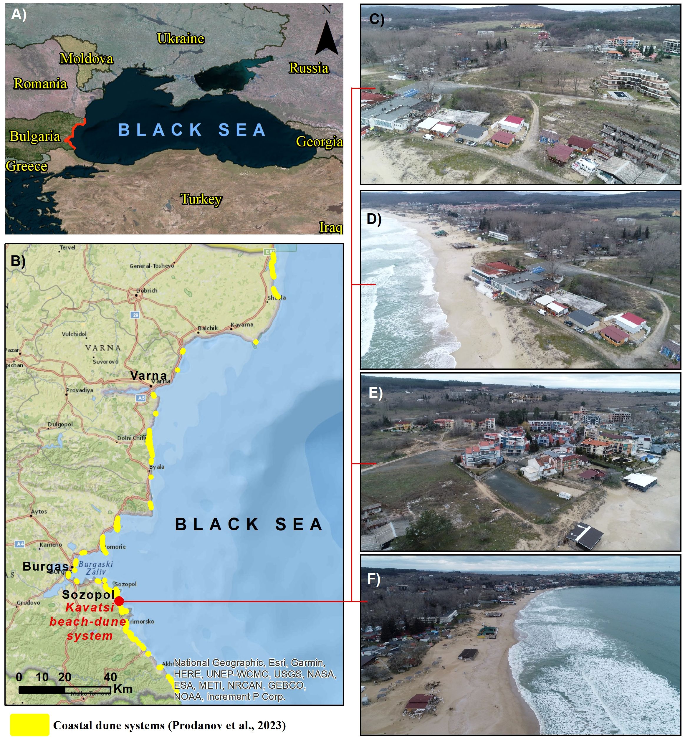
Figure 1. (A, B) Location of the Bulgarian Black Sea coastal dune systems; (C–F) Aerial photographs of the Kavatsi case study area (an example of a heavily man-modified beach-dune system along the Bulgarian Coast).
The depositional sandy area of the BBSC formed both primary and secondary DS, with varied geological, geomorphological and respective vegetation characteristics. Primary DS, incl. mainly embryonic dunes and foredunes, cover about 312 ha (32%) and are formed predominantly by aeolian processes, including wind-driven sand transport and deposition within pioneer vegetation communities. Secondary DS represent more mature and stabilized dune formations with approximately 676 ha area, formed initially by aeolian processes but later transformed into relict or fixed dunes due to vegetation development and the loss of direct sediment supply from the beach (Prodanov et al., 2023).
Dune systems in Bulgaria have been studied during the last decades (Passports of the Bulgarian Beaches, 1994; Kenderova et al., 1999; Petrov, 2013; Valchev, 2014, 2015; Sinnyovsky and Sinnyovska, 2016, 2017; Prodanov et al., 2019a, 2019b, 2020b, 2021a, 2023, 2024; Baltakova, 2023; Prodanov and Bekova, 2024; Prodanov, 2023). These studies reveal the five dune habitat types along the BBSC, all of them protected under Supplementary Appendix 1 of the Biodiversity Act, including 2110 Embryonic shifting dunes, 2120 Shifting dunes along the shoreline with Ammophila arenaria (white dunes), 2130 Fixed coastal dunes with herbaceous vegetation (grey dunes), 2180 Wooded dunes and 2190 Humid dune slacks (for more information see Supplementary Appendix 1). The typical/characteristic plant species associated with each habitat type are summarized in Table 1. These dune habitats share the respective areas on the BBSC: shifting (incipient) dunes (68.3 ha, 6.91%), shifting (white) dunes (150.3 ha, 15.21%), fixed (grey) dunes (546.27 ha, 55.28%), wooded dunes (222.61 ha, 22.53%) and humid dune slacks (0.94 ha, 0.09%) (Prodanov et al., 2023). About 70% of these habitats are within the Natura 2000 network (Gussev and Tzonev, 2015).
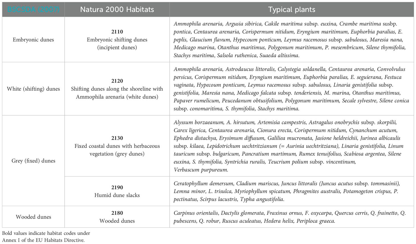
Table 1. Typical plant species (short check list) for coastal dune habitats along the BBSC.
3 Standard dune mapping procedure along the Bulgarian Black Sea coast
Why is a Standardized Mapping Procedure needed? The coastal DS along the BBSC have experienced degradation, which is predominantly driven by human-induced pressures, such as urbanization, construction of hydraulic structures and intensified recreational use (European Environmental Agency, https://cdr.eionet.europa.eu/). These processes have disrupted the natural evolution of the DS, resulting in a considerable reduction in their area to 988 ha, representing 0.0089% of Bulgaria’s land territory, and for a decade, the dune systems have diminished by over 12 ha, with five of them entirely lost. Over 5% of the CD is currently exposed to permanent anthropogenic impacts (Prodanov et al., 2023).
As a primary factor for this unfavorable trend, the initial inaccuracy and incompleteness in the mapping of DS procedure according to the Bulgarian legislative documents should be considered. Between 2012 and 2023, large portions of the coastal dunes were not mapped, and, respectively, they have not been included in the government Cadastral-Administrative Information System (CAIS), which contributed to their neglection and subsequent degradation (Prodanov et al., 2023). The persistent decline in the condition of CD and the critical gaps in their documentation have been alarmed by Bulgarian scientists (Tzonev et al., 2005; Gussev, 2015; Tzonev, 2015a, 2015b, 2015c, 2015d, 2015e; Tzonev and Gussev, 2015; Valcheva et al., 2018, 2020, 2021; Prodanov and Bekova, 2024; Prodanov et al., 2023), highlighting the urgent need for a standardized approach.
In response, the Ministry of Environment and Water (MoEW) has involved the Institute of Biodiversity and Ecosystem Research (IBER-BAS) and the Institute of Oceanology (IO-BAS) to collaboratively design a comprehensive, high-resolution mapping methodology for coastal dune habitats to ensure consistent and scientifically grounded representation and management of these sensitive ecosystems. By adopting a unified methodology, the SDMP will provide a reliable foundation for documenting the current state of dune systems and support informed decision-making for their conservation and sustainable use.
The SDMP represents a foundational framework established by the Ministry of Environment and Water (MoEW) of the Republic of Bulgaria with the support of IBER-BAS and IO-BAS, and Sofia University “St. Kliment Ohridski” from the scientific team of MapBGBeachDune project. This workflow proposes a minimum required surveys, yet a comprehensive set of research surveys, including remote sensing, geomorphological, geological, phytocoenological analyses, and Geographic Information System (GIS) analysis, based on best practice of successful dune surveys in the anthropogenic environment (Meshinev et al., 1994; Tzonev et al., 2005, 2015; Gussev and Tzonev, 2014; Janssen et al., 2016; Tashev et al., 2017; Vladimirov and Petrova, 2018; Marcenò et al., 2018; Valcheva et al., 2018, 2020, 2021; Prodanov et al., 2019a, 2019b, 2021a, 2021b, 2023; 2024; Prodanov, 2023; Prodanov and Bekova, 2023; Bekova and Prodanov, 2023; Kotsev et al., 2020), visualized in Figure 2. The aim is to ensure a sustainable, fast, accurate, and detailed approach to mapping protected dune habitats.
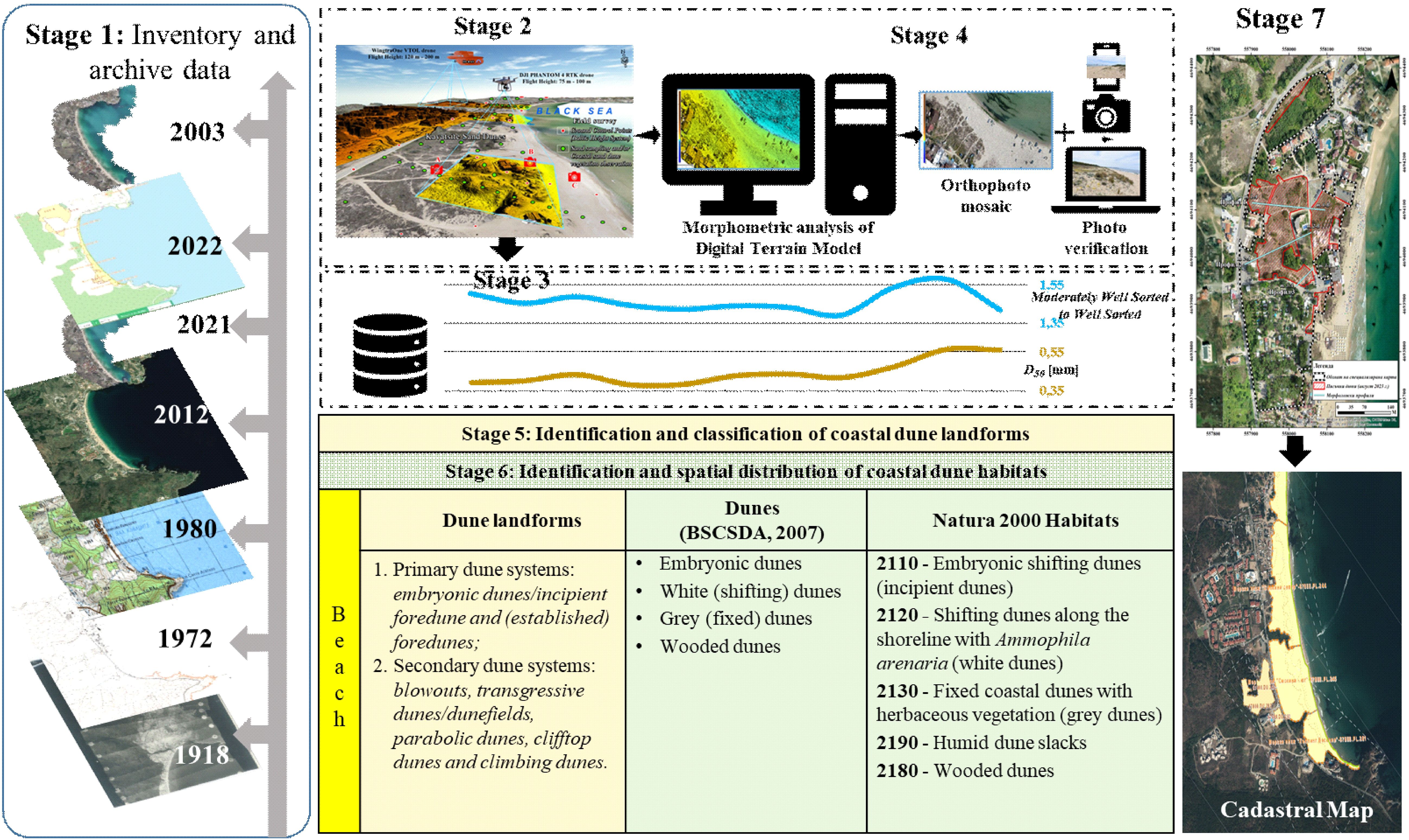
Figure 2. Workflow of the SDMP integrated into cadastral map creation along the BBSC.
3.1 Stage 1: inventory and archive data
Before embarking on field research, an initial inventory and previous (archival) review of existing data are conducted (Figure 2). This foundational step is critical for the following:
Establishing baselines: Gathering and reviewing historical data (e.g., old topographic maps, aerial photographs), previous geomorphological and environmental studies, satellite imagery from various sources, and time series available through platforms such as Google Earth. The satellite data include high-resolution images from the Google Earth Engine archive, providing visual records from the early 2000s to the present. Historical and thematic maps were sourced from Bulgarian national repositories and institutions, such as the Military Topographic Service, the Geocardfund of BAS and the Cadastre Agency. These materials help to establish a baseline spatial distribution of dune landforms over time;
Identifying gaps and GIS database organization: Through the inventory, gaps in the existing data are identified, which helps in planning the subsequent field research more effectively. Organizing and archiving these data in a systematic manner ensures easy access and reference throughout the project.
3.2 Stage 2: field research and data collection
The initial stage involves comprehensive field research and data collection (Figures 2, 3). This preparatory phase includes the summation of currently available data to establish a baseline for new findings. The field research encompasses:
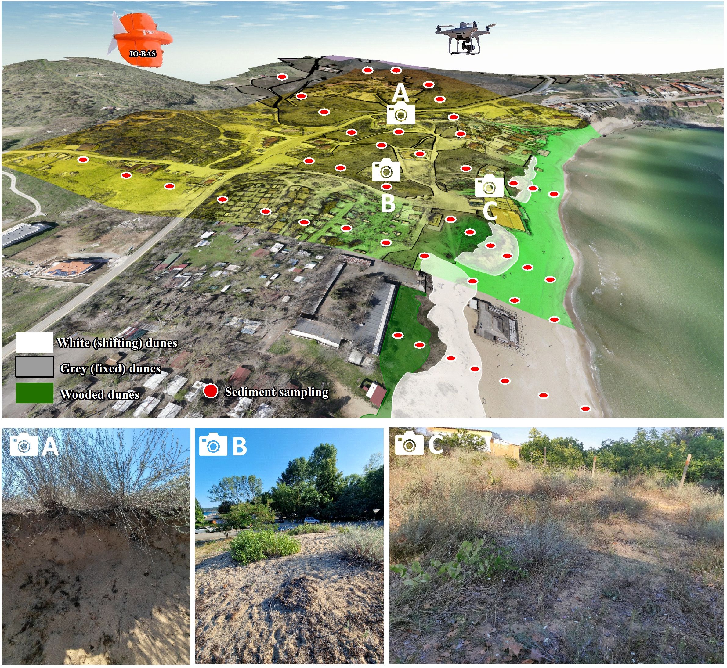
Figure 3. Three-dimensional visualization of different stages in the standard procedure of dune mapping along the BBSC (A – sand dunefield profile with Centaurea arenaria, Artemisia campesrtis/grey dunes/; B – dune crest with Cionura erecta, Scabiosa argentea, Artemisia campestris/grey dunes/C – dune field with Artemisia campestris, Scabiosa argentea, Paliurus spina-christi, Vitis sylvestris/grey dunes/).
3.2.1 UAS photogrammetry and LiDAR technology
High-resolution unmanned aerial system (UAS) surveys are conducted using RTK-equipped drones, ensuring geospatial precision compliant with national standards and photogrammetric best practices (Prodanov et al., 2023). Flights are planned with the overlapping nadir and oblique images (≥80/70%) to generate accurate orthophotomosaics and digital surface models (DSMs).
Recommended flight heights typically range between 60 and 120 meters above ground level (AGL), depending on the terrain complexity, desired spatial resolution, and vegetation density. A flight altitude of 60–100 m AGL is optimal for beach-dune systems, allowing for a balance between wide-area coverage and high spatial resolution. The spatial resolution (ground sampling distance – GSD) must meet or exceed 3–5 cm for orthophotos and 20–25 cm for DSMs in order to ensure a sufficient level of detail suitable for subsequent manual object-based image analysis (OBIA) workflows in later stages of the SDMP. The UAVs should be equipped with cameras capable of at least 20 MP resolution and high optical quality. Global or mechanical shutters are encouraged to reduce motion blur. The preferred flight mode is autonomous grid-based flight using pre-programmed waypoints with terrain-following capabilities. This ensures consistent altitude and overlaps across variable topography, which is particularly useful for dynamic and undulating dune landscapes.
When economically and technically feasible, UAS-LiDAR is integrated to enhance vertical accuracy and penetrate sparse vegetation cover, significantly improving topographic modeling of complex terrains, especially in vegetated grey and wooded dunes (Grohmann et al., 2020; Lin et al., 2019; Pinton et al., 2022). LiDAR data also supports volumetric analyses of dune migration and erosion/accretion trends (Frati et al., 2020). Despite its technical advantages and global recognition as a “gold standard” in terrain modeling, the application of LiDAR in Bulgaria remains limited. This is primarily due to the sensitive nature of high-resolution elevation data in the context of national security, particularly along the Bulgarian Black Sea coast, where military and strategic considerations impose restrictions on aerial scanning technologies. As such, the integration of LiDAR-based approaches is still emerging and must be aligned with national geospatial policies and security frameworks.
3.2.2 GPS and ground control measurements
The accuracy of digital surface models and raster orthophotomosaics is a priority goal in the proposed UAS approach. This implies the use of reference and control geodetic points. The control measurements are made with RTK GPS, providing high enough coordinate accuracy through a certified RTK network in Bulgaria. The achieved horizontal accuracy of 2 cm and height accuracy of 3 cm guarantee high spatial reliability of the conducted surveys.
Measurements are supported by topographic profiles and photographic documentation. All dune elements are systematically analyzed along geomorphological cross-shore profiles, which also serve dual purposes: they guide the selection of geological sampling locations and act as spatial control references during photogrammetric processing. Where feasible, drone-based 3D modeling is complemented with handheld GPS tracking and elevation benchmarks to further refine positional accuracy and feature delineation. In areas where drone imaging is not conducted due to technical, logistical, or regulatory limitations, GPS-based data acquisition is mandatory to ensure full spatial coverage and consistency of the recorded dune morphology.
3.2.3 Geomorphological survey
Identification and documentation of beach-dune system characteristics (beach face, beach face crest, summer berm, high beach winter berm, seaward dune slope, the crest and lee slope of the primary dune, a transition zone between primary and secondary dunes, middle sections of secondary dunes and the end of the secondary dunes).
3.2.4 Geological sampling
The collection is performed in transects perpendicular to the coastline. In addition to these standard cross-shore transects, sampling is also carried out in locations where a distinct transition from sandy substrates to sand-dominated soils (such as Arenosols) is observed, which is critical for substrate differentiation. Sediment is extracted from fixed geomorphic units (beach face, berms, dune slopes, crest, slacks) using standardized core samplers (Figure 3).
3.2.5 Phytocoenological survey
Detailed field observations to identify typical plants and plant communities in dune habitats and their potential spatial distribution. The process includes the collection of data and photographs on the floristic composition and structure of plant communities, their spatial occurrence and projective cover, the presence of invasive species in plant communities consistent with the phenological characteristics of species and communities, as well as the presence of threats and impacts.
3.3 Stage 3: processing of acquired data
The processing stage involves:
UAS data processing with photogrammetric software: generation of digital surface models (DSM) with minimum 20 cm/pix resolution and very high-resolution raster orthophotomosaics (GSD: 3÷5 cm/pix) – Figure 4;
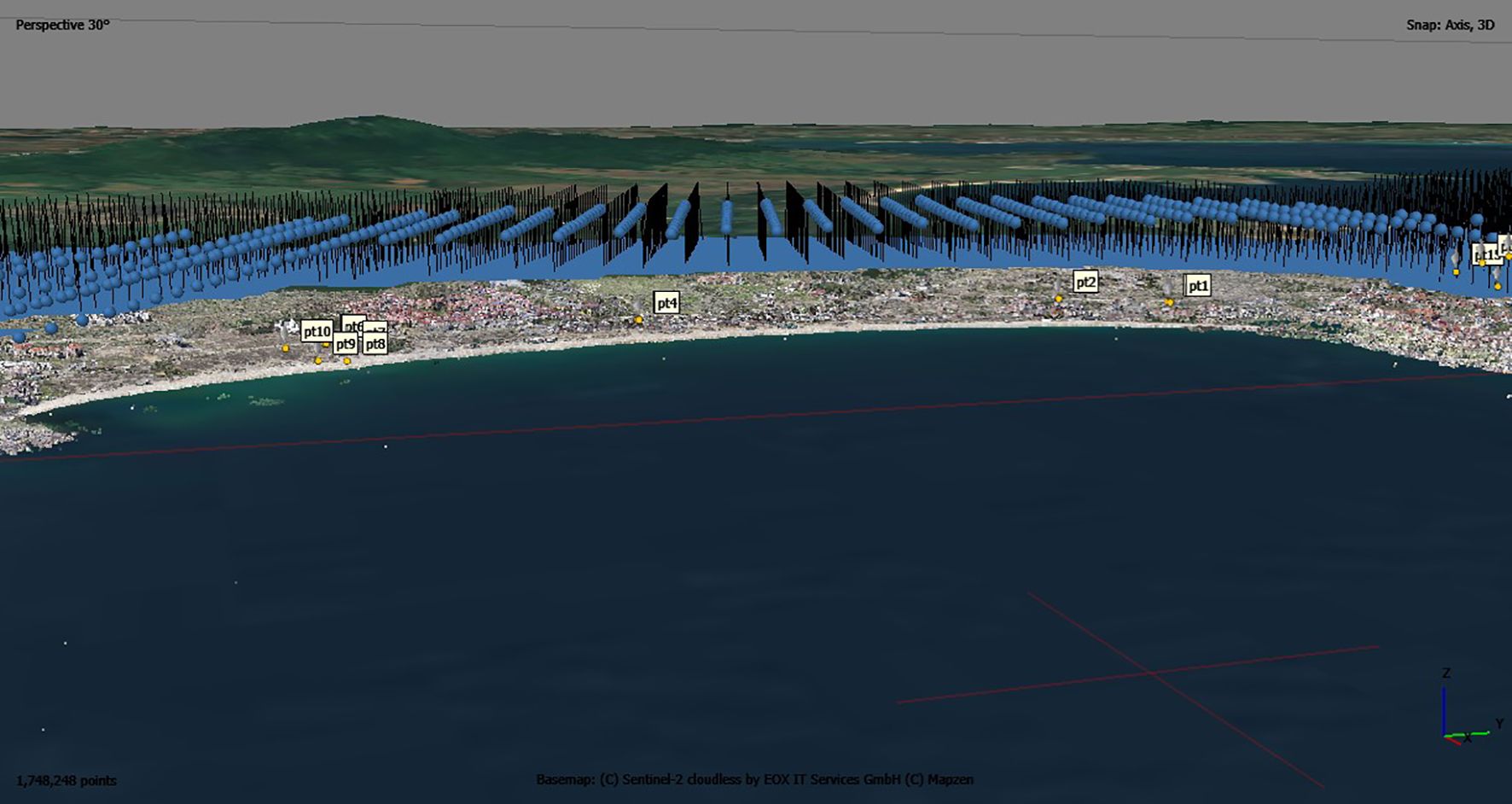
Figure 4. Photogrammetry processing of UAS data (location of aerial images and ground control points) in agisoft metashape software.
Phytocoenological data processing: Analysis of field data on plant communities, e.g., total vegetation cover, presence and cover of typical (characteristics) plant species, overall floristic composition and structure of plant communities and their spatial occurrence, presence and cover of invasive species, etc.;
Sedimentological analysis: Examining sediment profiles from various sections of the beach-dune system. The sediment stations are necessarily classified according to the Wentworth grain-size scale (Wentworth, 1922) or other classification if needed (Figure 5).
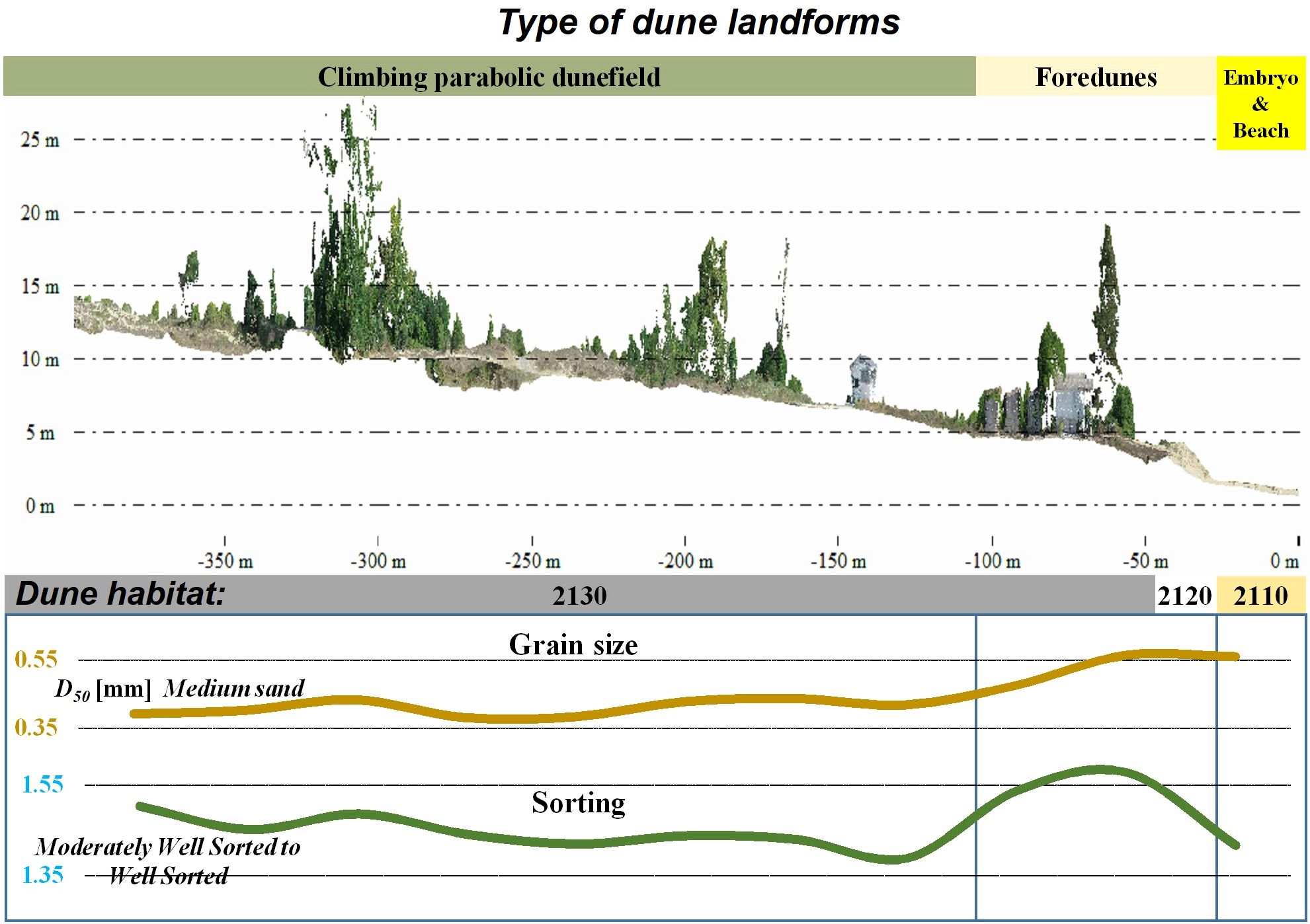
Figure 5. A general eco-geomorphological cross-shore profile of the “Kavatsi” beach-dune system.
3.4 Stage 4: GIS procedures and analyses
3D modeling and morphometric аnalysis of DSM/DTM for landform identification using GIS tools (Figure 6);
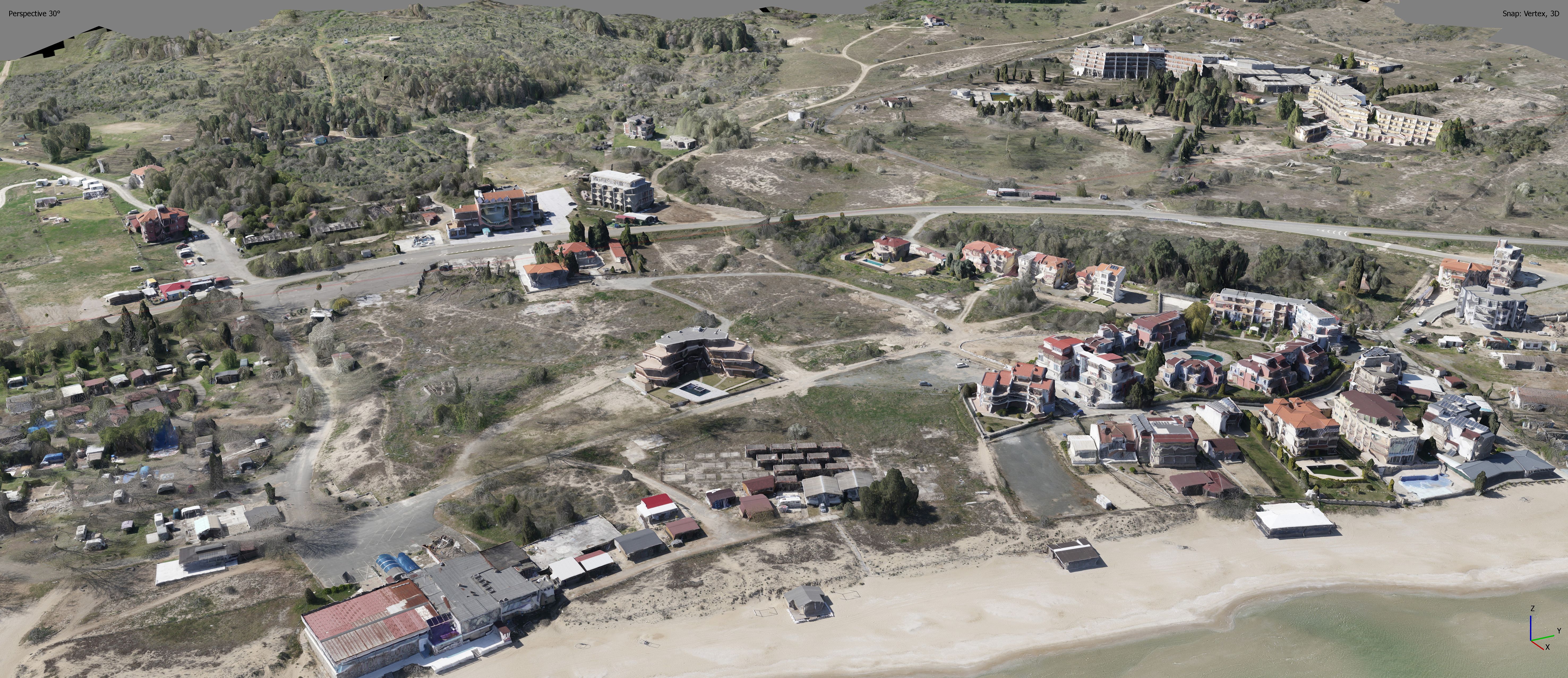
Figure 6. Three-dimensional photorealistic tiled model of the heavily modified central sector of the “Kavatsi” beach-dune system.
Orthophoto analysis: Examination of image data from baseline to present time, aiding in understanding temporal changes and texture interpretation.
3.5 Stage 5: identification and classification of coastal dune landforms
The methodology includes applying a manual object-based image interpretation approach to delineate geomorphological landforms. The process involved visual analysis of high-resolution drone imagery, where similar landform features were identified and digitized based on their shape, texture, pattern, and contextual relationships. Field data are used to support and validate the interpretation. This stage involves classifying the coastal dune landforms (Figures 7A, B) based on their location and geomorphological types (Sloss et al., 2012; Masselink et al., 2014; Prodanov et al., 2023; Hesp, 2011, 2024), such as:
− Primary DS: embryonic dunes/incipient foredune and (established) foredunes;
− Secondary DS: blowouts, transgressive dunes/dunefields, parabolic dunes, clifftop dunes, and climbing dunes.
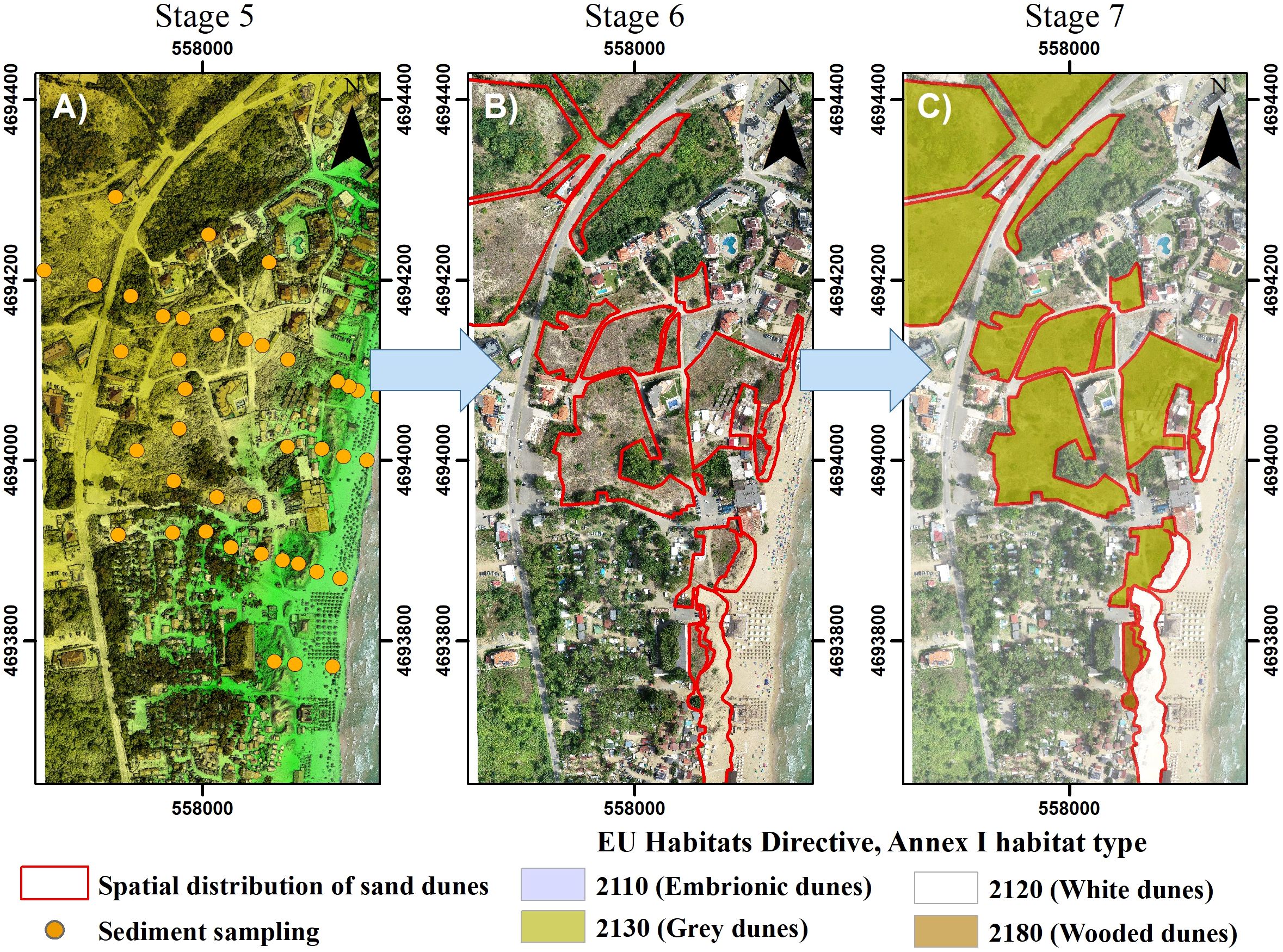
Figure 7. Producing data for the spatial distribution of coastal dune landforms and dune habitat for the creation of a special cadastral map along the BBSC. (A) Digital surface model from UAV photogrammetry; (B) Identified coastal dune landforms; (C) Map of dune habitat types.
3.6 Stage 6: identification and spatial distribution of coastal dune habitats
According to current methodological standards, GIS processing of phytocoenological data must ensure the differentiation of distinct dune habitat types based on their physiognomic characteristics, biophysical structure, and floristic composition. Habitat polygons are to be delineated through manual interpretation and spatial analysis within GIS environments such as QGIS, ArcGIS Pro, Global Mapper, etc.
Habitat classification is required to follow a hybrid approach, which combines supervised manual object-based image classification with field-verified data. This classification must adhere to the definitions provided in the Interpretation Manual of European Union Habitats (IMEUH, 2013) and Annex I of the Bulgarian Biodiversity Act (BDA). Dune habitat types are to be discriminated using a combination of spectral texture, vegetation structure and species composition, ensuring compliance with EU and national standards for habitat mapping and reporting (Table 1; Figure 7C).
3.7 Stage 7: creation of a high-resolution map of dune habitats
The final stage is the creation of a high-resolution map of the coastal dune habitat at a 1:1000 scale (Figure 7C). This involves integrating all collected data, designing the map layout, accurately representing features, and ensuring the map’s clarity and accuracy. Implementing these minimal research requirements in the SDMP significantly enhances data reliability regarding dunes. The implementation of these research requirements ensures the authenticity of data, contributing to a more informed and involved society in coastal management and conservation efforts. The creation of high-resolution maps of dune forms and habitats, as guided by the SDMP, serves crucial purposes, including cadastral mapping and habitat protection. By establishing a comprehensive and systematic approach, this workflow facilitates accurate and detailed mapping and fosters greater public trust in the scientific community and the process of dune cartography.
4 Results
The implementation of the SDMP, employing a drone-based methodology, facilitated the acquisition of a digital elevation model and orthophoto mosaic at a very high resolution. This approach ensured the acquisition of precise geospatial data concerning the distribution of CD. Supervised by coastal geomorphologists and botanist-phytocoenologists, the procedure consisted of multiple important stages aimed at investigating both geomorphological conditions and dune habitat types. The efficacy of this approach was evident as it emerged as an indispensable tool for the mapping and re-mapping of dunes, particularly in contentious dune areas, to address and offer sustainable solutions to dune maintenance challenges.
4.1 Pilot showcase: the Kavatsi dune system
The selection of the “Kavatsi” dune system as a pilot area for applying the methodology was proposed by MoEW under cadastral procedure within the region. This dune system is a prominent example of the profound modifications induced by human activities. Geomorphologically, the study area stands out due to its unique climbing type of DS, which is characteristic of the Medni Rid coastal region. The dune field’s climbing transgressive type is influenced by complex geomorphological and geological conditions, with the coastal settings comprising Middle Jurassic neointrusions to the south and Upper Cretaceous volcanic formations to the north. The beach strip primarily consists of Holocene and Quaternary fluvial materials (Petrova et al., 1994a, 1994b), with the sand composition being predominantly carbonate-quartz. The genesis of the beach is attributed to the movement of carbonate sand from adjacent underwater coastal slopes, as well as abraded material from cliff sections at Budjaka and St. Agalina localities.
In the Kavatsi DS area, dunes have been observed in the forefront of a foredune zone, which has long been anthropogenized by buildings, housing estates, restaurants, etc. (Figures 1C–F, 6). This dune system is a contact zone of interaction of natural processes and habitats, especially those of nature-conservation significance, human interventions, and economic and recreational interests. Unfortunately, different types of constructions or other placement of tourist infrastructure on the dunes, as well as the development of roads and parking lots, have been permitted for numerous years, leading to a loss of over 23% of its area in the past century (Prodanov et al., 2023). Following numerous alerts to the Ministry of Environment and Water regarding mapped secondary dunes, an initiative was undertaken to update the “Specialized cadastral map and registers” for the “Kavatsi-North” DS.
Dune landforms are integral components of specialized maps and are subject to mapping at a scale finer than 1:1000. The SDMP was executed with a specific focus on mapping the highly anthropogenized section within the secondary dunes (Figure 8). During the pilot application of SDMP in 2023, minimal variations in sediment grain size were observed. The primary dune system exhibited small width and dune size, with substantial anthropogenization of the foredunes, where numerous structures were differenced. Embryonic dunes were found in a narrow strip in front of the foredune toe, susceptible to annual destruction due to sand rake-up activities and tourist foot traffic on the beach. The secondary dune system comprised a climbing transgressive dunefield spanning from 6 meters above sea level to 61 meters above sea level (Figure 8).
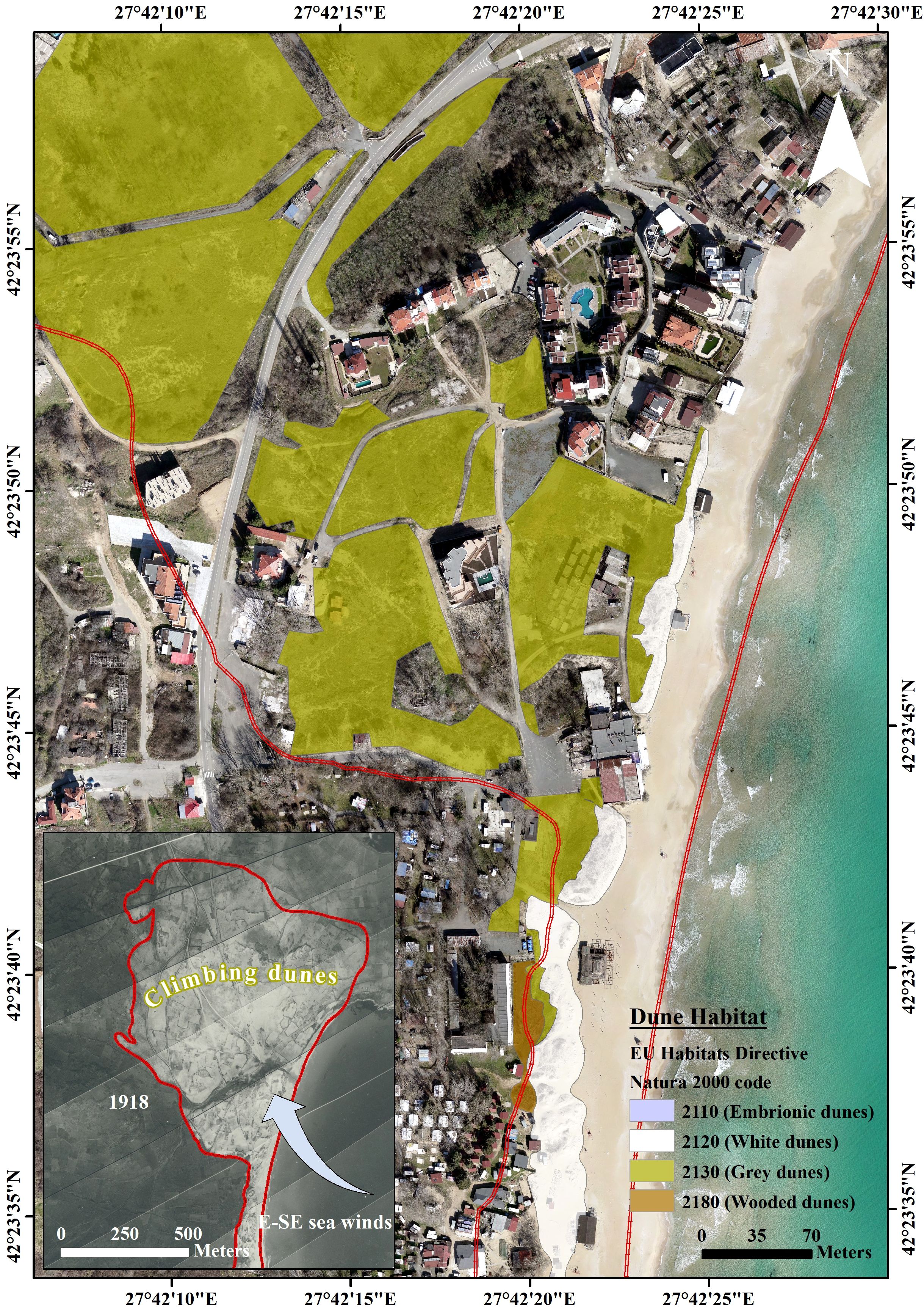
Figure 8. A final high-resolution map at a scale of 1:1000 of the remaining coastal dune habitats at the Kavatsi dune system, southern BBSC (archive data – Aerial photographs, 1918, present undisturbed dune area).
For the first time along the BBSC, an interdisciplinary team successfully mapped CD at a scale of 1:1000 using a very high-resolution UAS orthophotomosaic. The completion of this ambitious task has led to the development of a comprehensive map that accurately outlines the unique and diverse dune habitats (Figure 8).
4.2 Assessment advantages and limitations of methods
The proposed SDMP for the BBSC represents a significant step forward in addressing the urgent need for accurate and comprehensive mapping of coastal dune habitats along the BBSC. Based on analyses of the showcase results, this assessment aims to analyze the methods integrated into the SDMP and their goals, strengths, weaknesses, advantages, and limitations.
4.2.1 UAS Photogrammetry
The use of UAS photogrammetry in RTK mode aims to achieve high-accuracy and high-resolution imagery of beach-dune systems for detailed mapping. This method enables rapid data acquisition, facilitates timely mapping efforts and provides detailed visual data for analysis and interpretation. It offers flexibility in survey planning and execution, allowing for adjustments based on real-time observations. Additionally, it can be integrated with other survey techniques like LiDAR for comprehensive analysis. This method is cost-effective and efficient for data collection over large areas, allowing for the creation of detailed digital surface models (DSM) and orthophotomosaics. However, it is restricted by regulations governing drone usage and airspace restrictions. Challenges may arise in areas with dense vegetation or complex terrain, affecting data coverage and accuracy. Accurate georeferencing and model generation require careful consideration of data processing techniques. Weather conditions, such as high winds, can impact drone stability and data quality. Skilled personnel for operation and data processing are required.
4.2.2 Geomorphological survey
The geomorphological survey aims to identify and document various characteristics of beach-dune systems to understand their morphological characteristics. The method uses direct visual observation and documentation of landforms and sedimentary features, providing ground truth data for validating digital results from remote sensing. It provides detailed insights into the geomorphological features of CD, facilitating the identification of basic landforms and their spatial distribution. This method supports the assessment of dune stability and vulnerability to environmental changes. On the other hand, it relies on field personnel with expertise in geomorphology and sedimentology. Accurately delineating subtle landform boundaries may be challenging, and the scale and resolution of observations may limit spatial precision. This method is labor-intensive and time-consuming, particularly for large study areas, and subjectivity is possible in the interpretation of field research, as evidenced in previous mappings in Bulgaria. Accessibility constraints in remote or hard-to-reach terrain may also pose limitations.
4.2.3 Geological sampling
Geological sampling aims to characterize sediment properties and define the spatial boundaries of sand substrates within beach-dune systems. This method offers quantitative data for granulometric, mineralogical, or geochemical analysis, enabling comparisons with regional sedimentary records to infer broader environmental trends. It supports the assessment of sedimentological controls on coastal dune formation and evolution, providing essential data on sediment composition, grain size distribution, and stratigraphy. This method also supports the identification of sediment sources, transport pathways, and depositional environments, facilitating the interpretation of past environmental conditions and depositional settings. However, field sampling techniques may disturb or alter sediment structures. Challenges may arise in distinguishing between primary and reworked sedimentary deposits, and the availability of sampling equipment and logistical constraints may limit the method. Careful selection of sampling locations is necessary to ensure representative coverage, and sampling biases, such as preferential collection of certain sediment types, may occur. Additionally, the depth of sedimentary deposits accessible for sampling may be limited.
4.2.4 Phytocоenological survey
The phytocоenological survey aims to characterize plant communities within coastal dune habitats and assess their spatial distribution and ecological dynamics. This method observes ecosystem functioning, resilience, and response to environmental changes. It supports habitat mapping and conservation planning efforts and successfully integrates with remote sensing data for landscape-scale analysis. The survey provides valuable information on plant species composition, diversity and abundance, supporting the identification of habitat types. However, field observations may be biased by sampling methods or observer subjectivity, and accurately delineating vegetation boundaries in heterogeneous landscapes may be challenging. Good floristic and taxonomic expertise is required for accurate species identification and vegetation classification. The temporal variability in vegetation phenology and community dynamics may affect the survey. Site-specific factors, such as microclimate and substrate properties, may influence the results and the availability of reference datasets for species identification and habitat classification may be limited.
4.2.5 GIS procedures and analyses
GIS procedures and analyses aim to integrate spatial data from various sources, conduct morphometric analysis and create high-resolution maps of coastal dune habitats. It enables the creation of customized maps for specific applications and stakeholders, supporting 3D modeling and morphometric analysis for landform identification. GIS procedures provide orthophoto analysis and temporal change detection tools, enabling spatial data integration and analysis for multi-layered mapping. However, this method relies on the availability of high-quality spatial datasets for accurate analysis and may require substantial computational resources for processing large datasets. The spatial resolution and accuracy of input data sources may limit the method, and specialized software and technical expertise for data processing and analysis are required. Data interoperability and compatibility challenges between different formats may occur, and errors introduced during data manipulation and geoprocessing may affect the results.
5 Discussion
5.1 Applicability of the procedure
The proposed procedure for mapping beaches and dunes along the BBSC was developed within the framework of the Black Sea Coast Spatial Development Act of the Republic of Bulgaria (BSCSDA, 2007) and its associated regulation (Ordinance No. 1/2008). This legal and methodological foundation is essential for the production and maintenance of authoritative spatial data for coastal DS. The procedure not only aligns with national objectives for spatial data standardization and conservation but also meets interdisciplinary and cross-sectoral requirements. Its integration of geomorphological and phytocoenological methods reflects best practices in coastal habitat mapping, where both physical form and ecological function are essential for the correct classification (Laporte-Fauret et al., 2020; Innangi et al., 2025). Given the dynamic nature of coastal dunes and their status as priority habitats under both national and European legislation, robust, legally compliant mapping is indispensable. Furthermore, as Bulgarian legislation is harmonized with EU directives like the Habitats Directive, the adoption of standard procedures such as SDMP promotes international coherence in coastal governance.
5.2 Evaluating the adaptability and impact of the SDMP
5.2.1 Effectiveness of used methods in SDMP
The successful pilot application of the SDMP on the heavily human-impacted “Kavatsi” DS demonstrates its robustness and adaptability. By integrating multidisciplinary methods, including UAS photogrammetry, geomorphological field surveys, and GIS-based analysis, the SDMP is capable of capturing the complex interactions among physical landscape features, vegetation patterns, and human pressures. High-resolution UAS photogrammetry has proven to be an efficient, non-invasive, and cost-effective tool for producing spatially accurate data even in challenging terrain (Suo et al., 2019). These outcomes are consistent with international best practices in coastal dune monitoring, as evidenced by Cruz et al. (2023), who highlight the potential of UAVs for fine-scale habitat classification and temporal monitoring. In parallel, Ma et al. (2024) developed a comprehensive method that integrates LiDAR, GNSS, and remote sensing for evaluating coastal dune evolution, an approach methodologically aligned with the SDMP. This compatibility not only validates the SDMP’s interdisciplinary structure but also highlights its potential for integration into broader frameworks for coastal zone monitoring and management.
Moreover, the SDMP reflects emerging ecological perspectives on dune morphology and function. The emphasis on species-level vegetation assessments and structural-functional characteristics, such as those discussed by Hacker et al. (2019), aligns with a growing body of evidence that dune-building vegetation plays a critical role in sediment dynamics and dune stability. By incorporating these insights, the SDMP enhances its ecological relevance and paves the way for its further development through the integration of functional trait-based mapping and vegetation-climate-sediment interactions.
5.2.2 Replicability of SDMP
A central strength of SDMP is its standardization, enabling consistent application across over 46 beach-dune systems, separated into 250 cadastral maps on the BBSC. By ensuring uniform methods for UAS data collection, geomorphological and vegetation analysis, and GIS-based interpretation, the procedure facilitates not only temporal monitoring but also spatial comparisons critical for coastal management (Guisado-Pintado et al., 2019; Almonacid-Caballer et al., 2025). This level of standardization also aligns with international trends toward scalable dune monitoring (Cruz et al., 2023; Marzialetti et al., 2021), though site-specific calibration may be necessary for geomorphologically distinct regions (Tysiąc et al., 2025). Alarming losses documented in recent years along the BBSC, driven by urban expansion, recreational overuse, and tourism, underscore the urgent need for updated dune mapping (Prodanov et al., 2023). As seen in other European regions, high-resolution drone monitoring can uncover subtle but ecologically significant degradation patterns (Laporte-Fauret et al., 2020; Pinton et al., 2022). Moreover, multi-temporal drone surveys enhance the detection of dune mobility and vegetation succession, supporting restoration planning (James et al., 2024).
5.2.3 Addressing human-induced impacts
In examples like “Kavatsi” DS, where human pressures are acute, fine-scale UAV data and field-based surveys enable precise detection of unauthorized development, vegetation degradation, and habitat fragmentation. The SDMP output integrating species-level vegetation data and landform characterization forms a solid base for targeted interventions and enforcement. Numerous recent studies have documented the wide range of anthropogenic pressures on coastal dunes across Europe and beyond, including tourism infrastructure, road and parking construction, and recreational trampling, all of which alter vegetation composition and hinder dune mobility (Foti et al., 2021; Defeo et al., 2009; Malavasi et al., 2014; Innangi et al., 2025). These impacts are often exacerbated by the introduction of invasive species and the fragmentation of native vegetation patches, especially in urban settings (Aguilera et al., 2022). Thus, accurate spatial data combined with ecological field indicators are indispensable for planning restoration and mitigating ongoing degradation.
5.2.4 Future opportunities
The modular structure of SDMP allows for the integration of emerging technologies. For example, UAV-LiDAR systems provide enhanced penetration of vegetated areas and enable accurate ground elevation modeling even in complex terrain (Lin et al., 2019; Pinton et al., 2022). Additionally, machine learning techniques, such as Random Forest classifiers, have demonstrated strong performance in coastal vegetation mapping (James et al., 2024; Laporte-Fauret et al., 2020). Algorithms combining multispectral imagery and functional trait data (e.g., supervised classification of eco-functional units) also show the potential to enhance habitat mapping precision (Innangi et al., 2025; Belcore et al., 2024). As demonstrated by Almonacid-Caballer et al. (2025), the reuse of historical aerial imagery offers another promising avenue for generating long-term baselines of dune morphology, contributing to sediment budget assessments and erosion forecasting.
6 Conclusion
The SDMP for the BBSC represents a significant advancement in coastal dune conservation. By integrating various scientific methods and leveraging modern technology, the SDMP provides a robust framework for accurate mapping and effectively managing coastal dune habitats. The pilot application on the “Kavatsi” dune system highlights the procedure’s potential to address anthropogenic impacts and support sustainable coastal management. Future efforts should focus on scaling the procedure, integrating new technologies, and using the data to inform climate resilience strategies and policy development. The SDMP not only aids in preserving the ecological integrity of DS but also contributes to the broader goal of sustainable coastal zone management.
Data availability statement
The data analyzed in this study is subject to the following licenses/restrictions: Data may be provided with the consent of the Ministry of Environment and Water of the Republic of Bulgaria. Requests to access these datasets should be directed toYnByb2Rhbm92QGlvLWJhcy5iZw==.
Author contributions
BP: Conceptualization, Data curation, Funding acquisition, Methodology, Project administration, Software, Supervision, Visualization, Writing – original draft, Writing – review & editing. CG: Conceptualization, Writing – original draft, Writing – review & editing. DS: Conceptualization, Writing – original draft, Writing – review & editing. MV: Conceptualization, Writing – original draft, Writing – review & editing. RB: Writing – original draft, Writing – review & editing. AB: Conceptualization, Writing – original draft, Writing – review & editing. RT: Writing – original draft, Writing – review & editing. JP: Supervision, Writing – review & editing.
Funding
The author(s) declare that financial support was received for the research and/or publication of this article. Project “Mapping and Spatiotemporal Analysis of Beach-Dune Systems on the Southern Bulgarian Black Sea Coast: Evolution, Anthropogenic Pressure, and Ecological Risks to Dune Habitats (MapBGBeachDune)” of the Institute of Oceanology – Bulgarian academy of sciences, Grant № КП-06-Н84/5-16.12.2024 under Competition for financial support of basic research projects of Bulgarian National Science Fund.
Acknowledgments
This work was developed by a scientific team of the project “Mapping and Spatiotemporal Analysis of Beach-Dune Systems on the Southern Bulgarian Black Sea Coast: Evolution, Anthropogenic Pressure, and Ecological Risks to Dune Habitats (MapBGBeachDune)” of the Institute of Oceanology – Bulgarian academy of sciences, Grant № КП-06-H84/5-16.12.2024 under Competition for financial support of basic research projects of Bulgarian National Science Fund. The authors express their sincere gratitude to the Ministry of Environment and Water of the Republic of Bulgaria for their collaboration in the development of the Standard Dune Mapping Procedure.
Conflict of interest
The authors declare that the research was conducted in the absence of any commercial or financial relationships that could be construed as a potential conflict of interest.
Generative AI statement
The author(s) declare that no Generative AI was used in the creation of this manuscript.
Publisher’s note
All claims expressed in this article are solely those of the authors and do not necessarily represent those of their affiliated organizations, or those of the publisher, the editors and the reviewers. Any product that may be evaluated in this article, or claim that may be made by its manufacturer, is not guaranteed or endorsed by the publisher.
Supplementary material
The Supplementary Material for this article can be found online at: https://www.frontiersin.org/articles/10.3389/fmars.2025.1579724/full#supplementary-material
Abbreviations
BBSC, Bulgarian Black Sea Coast; SDMP, Standard Dune Mapping Procedure; CD, coastal dunes; DS, dune systems.
References
Aagaard T., Orford J., and Murray A. S. (2007). Environmental controls on coastal dune formation; Skallingen Spit, Denmark. Geomorphology 83, 29–47. doi: 10.1016/j.geomorph.2006.06.007
Agrillo E., Filipponi F., Salvati R., Pezzarossa A., and Casella L. (2023). Modeling approach for coastal dune habitat detection on coastal ecosystems combining very high-resolution UAV imagery and field survey. Remote Sens. Ecol. Conserv. 9, 251–267. doi: 10.1002/rse2.308
Aguilera M. A., Pacheco S., and Manzur T. (2022). Human-derived effects and failure in management drive coastal urban foredune degradation and novel vegetation structure. J. Environ. Manage. 311, 114843. doi: 10.1016/j.jenvman.2022.114843
Aguilera M. A., Tapia J., Gallardo C., Núñez P., and Varas-Belemmi K. (2020). Loss of coastal ecosystem spatial connectivity and services by urbanization: Natural-to-urban integration for bay management. J. Environ. Manage. 276, 111297. doi: 10.1016/j.jenvman.2020.111297
Al-Dabi H., Koch M., Al-Sarawi M., and El-Baz F. (1997). Evolution of sand dune patterns in space and time in north-western Kuwait using Landsat images. J. Arid Environments 36, 15–24. doi: 10.1006/jare.1996.0230
Almonacid-Caballer J., Cabezas-Rabadán C., Gorkovchuk D., Palomar-Vázquez J., and Pardo-Pascual J. E. (2025). Re-using historical aerial imagery for obtaining 3D data of beach-dune systems: A novel refinement method for producing precise and comparable DSMs. Remote Sens. 17, 594. doi: 10.3390/rs17040594
Andrews B. D., Gares P. A., and Colby J. D. (2002). Techniques for GIS modeling of coastal dunes. Geomorphology 48, 289–308. doi: 10.1016/s0169-555x(02)00186-1
Anthony E. J. (2013). Storms, shoreface morphodynamics, sand supply, and the accretion and erosion of coastal dune barriers in the southern North Sea. Geomorphology 199, 8–21. doi: 10.1016/j.geomorph.2012.06.007
Arens S., Jungerius P., and van der Meulen F. (2001). Coastal dunes. Habitat conservation: managing the physical environment. Eds. Warren A. and French J. R. (Chichester: John Wiley & Sons Ltd), 231–272, ISBN: 0-471-98499-X.
Baltakova A. (2023). Coastal foredune enlargement – a sign of sea-level change? An example from the Kavatsite beach-dune system. Rev. Bulgarian Geological Soc. 84, 329–332. doi: 10.52215/rev.bgs.2023.84.3.329
Bañón L., Pagán J. I., López I., Banon C., and Aragonés L. (2019). Validating UAS-based photogrammetry with traditional topographic methods for surveying dune ecosystems in the spanish mediterranean coast. J. Marine Sci. Eng. 7, 297. doi: 10.3390/jmse7090297
Barbaro G., Foti G., Barillà G. C., and Frega F. (2021). Beach and dune erosion: causes and interventions, case study: kaulon archaeological site. J. Marine Sci. Eng. 10, 14. doi: 10.3390/jmse10010014
Bazzichetto M., Malavasi M., Acosta A. T. R., and Carranza M. L. (2016). How does dune morphology shape coastal EC habitats occurrence? A remote sensing approach using airborne LiDAR on the Mediterranean coast. Ecol. Indic. 71, 618–626. doi: 10.1016/j.ecolind.2016.07.044
BDA (2002). Biological Diversity Act (State gazette, Sofia). Available at: https://lex.bg/bg/laws/ldoc/2135456926 (Accessed May 1, 2025).
Belcore E., Latella M., Piras M., and Camporeale C. (2024). Enhancing precision in coastal dunes vegetation mapping: ultra-high resolution hierarchical classification at the individual plant level. Int. J. Remote Sens. 45, 4527–4552. doi: 10.1080/01431161.2024.2354135
Bekova R. and Prodanov B. (2023). Assessment of beach macrolitter using unmanned aerial systems: A study along the Bulgarian Black Sea Coast. Marine Pollution Bulletin 196, 115625. doi: 10.1016/j.marpolbul.2023.115625
Bridges T. S., Smith J. M., King J. K., Simm J. D., Dillard M., deVries J., et al. (2022). Coastal natural and nature-based features: international guidelines for flood risk management. Front. Built Environ. 8. doi: 10.3389/fbuil.2022.904483
BSCSDA (2007). Black Sea Coast Spatial Development Act of the Republic of Bulgaria. Available online at: https://lex.bg/laws/ldoc/2135555697 (Accessed May 1, 2025).
Calderisi G., Cogoni D., Pinna M. S., and Fenu G. (2021). Recognizing the relative effects of environmental versus human factors to understand the conservation of coastal dune areas. Regional Stud. Marine Sci. 48, 102070. doi: 10.1016/j.rsma.2021.102070
Caroti G., Piemonte A., and Pieracci Y. (2018). “Low-altitude UAV-borne remote sensing in dunes environment: shoreline monitoring and coastal resilience,” in Computational Science and Its Applications – ICCSA 2018 (Springer International Publishing, Cham), 281–293. doi: 10.1007/978-3-319-95174-4_23
Carr J. (2021). Using Drones And Image Classification Tools To Map Complex Coastal Habitats Along The Upland-Subtidal Gradient In Massachusetts Embayments. Available online at: http://hdl.handle.net/20.500.13013/2915 (Accessed May 1, 2025).
Casagrande G., Bezzi A., Fracaros S., Martinucci D., Pillon S., Salvador P., et al. (2023). Quantifying transgressive coastal changes using UAVs: dune migration, overwash recovery, and barrier flooding assessment and interferences with human and natural assets. J. Marine Sci. Eng. 11, 1044. doi: 10.3390/jmse11051044
Catto N. (2002). Anthropogenic pressures on coastal dunes, southwestern Newfoundland. Can. Geographies 46, 17–32. doi: 10.1111/j.1541-0064.2002.tb00728.x
CBD. (1992). Convention on Biological Diversity. United Nations Conference on Environment and Development (UNCED), Rio de Janeiro, 5 June 1992. Available online at: https://www.cbd.int/doc/legal/cbd-en.pdf.
CBD. (2022). Decision adopted by the Conference of the Parties to the Convention on Biological Diversity. 15/4. Kunming-Montreal Global Biodiversity Framework. COP-15, Montreal, 19 December 2022. Published 2024. Available online at: https://www.cbd.int/doc/decisions/cop-15/cop-15-dec-04-en.pdf.
Ciccarelli D. (2014). Mediterranean coastal sand dune vegetation: Influence of natural and anthropogenic factors. Environ. Manage. 54, 194–204. doi: 10.1007/s00267-014-0290-2
Constitution of the Republic of Bulgaria (1991). Available online at: https://www.parliament.bg/en/const (Accessed May 1, 2025).
Contreras-de-Villar F., García F. J., Muñoz-Perez J. J., Contreras-de-Villar A., Ruiz-Ortiz V., López-García P., et al. (2023). Analysis of topographic surveys with RPAS in steep coastal dunes. Land 12, 1729. doi: 10.3390/land12091729
Costas S., Jerez S., Trigo R. M., Goble R., and Rebêlo L. (2012). Sand invasion along the Portuguese coast forced by westerly shifts during cold climate events. Quaternary Sci. Rev. 42, 15–28. doi: 10.1016/j.quascirev.2012.03.008
Council Directive 92/43/EEC (1992). Council Directive 92/43/EEC of 21 May 1992 on the conservation of natural habitats and of wild fauna and flora. Available online at: http://data.europa.eu/eli/dir/1992/43/2013-07-01 (Accessed May 1, 2025).
Cruz C., O’Connell J., McGuinness K., Martin J. R., Perrin P. M., and Connolly J. (2023). Assessing the effectiveness of UAV data for accurate coastal dune habitat mapping. Eur. J. Remote Sens. 56, 1–17. doi: 10.1080/22797254.2023.2191870
D’Alessandro F., Tomasicchio G. R., and Frega F. (2022). Beach-dune system morphodynamics. J. Marine Sci. Eng. 10, 802. doi: 10.3390/jmse10060802
Defeo O., McLachlan A., Schoeman D. S., Schlacher T. A., Dugan J., Jones A., et al. (2009). Threats to sandy beach ecosystems: A review. Estuarine Coastal Shelf Sci. 81, 1–12. doi: 10.1016/j.ecss.2008.09.022
De Giglio M., Goffo F., Greggio N., Merloni N., Dubbini M., and Barbarella M. (2017). Satellite and unmanned aerial vehicle data for the classification of sand dune vegetation. Int. Arch. Photogrammetry Remote Sens. Spatial Inf. Sci. XLII-3/W2, 43–50. doi: 10.5194/isprs-archives-xlii-3-w2-43-2017. XLII-3/W2.
De Giglio M., Greggio N., Goffo F., Merloni N., Dubbini M., and Barbarella M. (2019). Comparison of pixel- and object-based classification methods of unmanned aerial vehicle data applied to coastal dune vegetation communities: casal borsetti case study. Remote Sens. 11, 1416. doi: 10.3390/rs11121416
Delgado-Fernandez I. and Davidson-Arnott R. (2011). Meso-scale aeolian sediment input to coastal dunes: The nature of aeolian transport events. Geomorphology 126, 217–232. doi: 10.1016/j.geomorph.2010.11.005
Doyle T. B. and Woodroffe C. D. (2018). The application of LiDAR to investigate foredune morphology and vegetation. Geomorphology 303, 106–121. doi: 10.1016/j.geomorph.2017.11.005
Duffy J., Shutler J., Witt M., DeBell L., and Anderson K. (2018). Tracking fine-scale structural changes in coastal dune morphology using kite aerial photography and uncertainty-assessed structure-from-motion photogrammetry. Remote Sens. 10, 1494. doi: 10.3390/rs10091494
EEA (2015). European Environment Agency, State of nature in the EU: results from reporting under the nature directives 2007-2012 (Luxembourg: Publications Office). doi: 10.2800/603862
EEA (2020). European Environment Agency, State of nature in the EU: results from reporting under the nature directives 2013-2018 (Luxembourg: Publications Office). doi: 10.2800/088178
El Mrini A., Anthony E. J., Maanan M., Taaouati M., and Nachite D. (2012). Beach-dune degradation in a Mediterranean context of strong development pressures and the missing integrated management perspective. Ocean Coastal Manage. 69, 299–306. doi: 10.1016/j.ocecoaman.2012.08.004
European Commission (2008). Article 17 Technical Report 2001 – 2006 (European Topic Centre on Biological Diversity). Available at: https://www.eionet.europa.eu/etcs/etc-be/activities/reporting/article-17/outcomes-2001-2006 (Accessed May 1, 2025).
Fabbri S., Grottoli E., Armaroli C., and Ciavola P. (2021). Using high-spatial resolution UAV-derived data to evaluate vegetation and geomorphological changes on a dune field involved in a restoration endeavour. Remote Sens. 13, 1987. doi: 10.3390/rs13101987
Feagin R. A., Furman M., Salgado K., Martinez M. L., Innocenti R. A., Eubanks K., et al. (2019). The role of beach and sand dune vegetation in mediating wave run-up erosion. Estuarine Coastal Shelf Sci. 219, 97–106. doi: 10.1016/j.ecss.2019.01.018
Feagin R. A., Sherman D. J., and Grant W. E. (2005). Coastal erosion, global sea-level rise, and the loss of sand dune plant habitats. Front. Ecol. Environ. 3, 359–364. doi: 10.1890/1540-9295
De Figueiredo S. A., Calliari L. J., and MaChado A. A. (2018). Modelling the effects of sea-level rise and sediment budget in coastal retreat at Hermenegildo Beach, Southern Brazil. Braz. J. Oceanography 66, 210–219. doi: 10.1590/s1679-87592018009806602
Fisher A. and Hesse P. P. (2019). The response of vegetation cover and dune activity to rainfall, drought and fire observed by multitemporal satellite imagery. Earth Surface Processes Landforms 44, 2957–2967. doi: 10.1002/esp.4721
FitzGerald D. M., Fenster M. S., Argow B. A., and Buynevich I. V. (2008). Coastal impacts due to sea-level rise. Annu. Rev. Earth Planetary Sci. 36, 601–647. doi: 10.1146/annurev.earth.35.031306.140139
Flores-de-Santiago F., Valderrama-Landeros L., Villaseñor-Aguirre J., Álvarez-Sánchez L. F., Rodríguez-Sobreyra R., and Flores-Verdugo F. (2023). Detection of beach–dune geomorphic changes by means of satellite and unmanned aerial vehicle data: the case of altamura island in the gulf of California. Coasts 3, 383–400. doi: 10.3390/coasts3040023
Fontán-Bouzas Á., Andriolo U., Silva P. A., and Baptista P. (2022). Wave impact analysis on a beach-dune system to support coastal management and nourishment works: the showcase of mira, Portugal. Front. Marine Sci. 9. doi: 10.3389/fmars.2022.861569
Foti G., Barbaro G., Barillà G. C., and Frega F. (2021). Effects of anthropogenic pressures on dune systems – case study: calabria (Italy). J. Marine Sci. Eng. 10, 10. doi: 10.3390/jmse10010010
Frati G., Launeau P., Robin M., Giraud M., Juigner M., Debaine F., et al. (2020). Coastal sand dunes monitoring by low vegetation cover classification and digital elevation model improvement using synchronized hyperspectral and full-waveform LiDAR remote sensing. Remote Sens. 13, 29. doi: 10.3390/rs13010029
Gao J., Kennedy D. M., and Konlechner T. M. (2020). Coastal dune mobility over the past century: A global review. Prog. Phys. Geography: Earth Environ. 44, 814–836. doi: 10.1177/0309133320919612
Gonçalves J. A. and Henriques R. (2015). UAV photogrammetry for topographic monitoring of coastal areas. ISPRS J. Photogrammetry Remote Sens. 104, 101–111. doi: 10.1016/j.isprsjprs.2015.02.009
Green D. R., Hagon J. J., Gómez C., and Gregory B. J. (2019). “Using low-cost UAVs for environmental monitoring, mapping, and modelling: examples from the coastal zone,” in Coastal Management (Amsterdam, Netherlands: Elsevier), 465–501. doi: 10.1016/b978-0-12-810473-6.00022-4
Grohmann C. H., Garcia G. P. B., Affonso A. A., and Albuquerque R. W. (2020). Dune migration and volume change from airborne LiDAR, terrestrial LiDAR and Structure from Motion-Multi View Stereo. Comput. Geosciences 143, 104569. doi: 10.1016/j.cageo.2020.104569
Guisado-Pintado E., Jackson D. W. T., and Rogers D. (2019). 3D mapping efficacy of a drone and terrestrial laser scanner over a temperate beach-dune zone. Geomorphology 328, 157–172. doi: 10.1016/j.geomorph.2018.12.013
Gussev C. (2015). “Mediterranean tall-grass communities along rivers and in dune depressions,” in Red Data Book of the Republic of Bulgaria, vol. 3. Natural habitats (BAS & MoEW, Sofia). Available at: http://e-ecodb.bas.bg/rdb/en/vol3/18C3.html.
Gussev C. and Tzonev R. (2014). Natural habitats of European importance in the Strandzha Protected Area. Directorate of Nature Park “Strandja. Malko Tarnovo 304.
Gussev C. and Tzonev R. (2015). “European ecological network NATURA 2000 in Bulgaria,” in Red Data Book of the Republic of Bulgaria, vol. 3 . Ed. Biserkov V. and Gussev C.. Natural habitats (BAS & MoEW, Sofia). Available at: http://e-ecodb.bas.bg/rdb/en/vol3/07natura2000.html.
Hacker S. D., Jay K. R., Cohn N., Goldstein E. B., Hovenga P. A., Itzkin M., et al. (2019). Species-specific functional morphology of four US atlantic coast dune grasses: biogeographic implications for dune shape and coastal protection. Diversity 11, 82. doi: 10.3390/d11050082
Hanley M. E., Hoggart S. P. G., Simmonds D. J., Bichot A., Colangelo M. A., Bozzeda F., et al. (2014). Shifting sands? Coastal protection by sand banks, beaches and dunes. Coastal Eng. 87, 136–146. doi: 10.1016/j.coastaleng.2013.10.020
Hantson W., Kooistra L., and Slim P. A. (2012). Mapping invasive woody species in coastal dunes in the Netherlands: a remote sensing approach using LIDAR and high-resolution aerial photographs. Appl. Vegetation Sci. 15, 536–547. doi: 10.1111/j.1654-109x.2012.01194.x
Hesp P. (2011). Dune coasts. Treatise Estuarine Coastal Sci. 3, 193–221. doi: 10.1016/b978-0-12-374711-2.00310-7
Hesp P. A. (2024). “Coastal dunes: types, initiation, morphology, evolution, and relationships to surfzone-beach systems and climate,” in Treatise on Estuarine and Coastal Science, 2nd ed. (Amsterdam, Netherlands: Elsevier), 866–903. doi: 10.1016/b978-0-323-90798-9.00074-3
Hugenholtz C. H., Levin N., Barchyn T. E., and Baddock M. C. (2012). Remote sensing and spatial analysis of aeolian sand dunes: A review and outlook. Earth-Science Rev. 111, 319–334. doi: 10.1016/j.earscirev.2011.11.006
IMEUH (2013). Interpretation Manual of European Union Habitats, version EUR 28. Available online at: https://eunis.eea.europa.eu/references/2435 (Accessed May 1, 2025).
Innangi M., Di Febbraro M., Balsi M., Colonna G., Finizio M., Pontieri F., et al. (2025). A novel high-resolution eco-functional vegetation mapping of coastal dunes. Ecol. Indic. 171, 113157. doi: 10.1016/j.ecolind.2025.113157
Innangi M., Marzialetti F., Di Febbraro M., Acosta A. T. R., De Simone W., Frate L., et al. (2023). Coastal Dune Invaders: Integrative Mapping of Carpobrotus sp. pl. (Aizoaceae) Using UAVs. Remote Sens. 15, 503. doi: 10.3390/rs15020503
James D., Collin A., Bouet A., Perette M., Dimeglio T., Hervouet G., et al. (2024). Multi-temporal drone mapping of coastal ecosystems in restoration: seagrass, salt marsh, and dune. J. Coastal Res. 113, 524–528. doi: 10.2112/jcr-si113-103.1
Janssen J. A. M., Rodwell J. S., Garcia Criado M., Gubbay S., Haynes T., Nieto A., et al. (2016). “European red list of habitats,” in Part 2. Terrestrial and freshwater habitats (Publications Office of the European Union, Luxembourg).
Johnston K. K., Dugan J. E., Hubbard D. M., Emery K. A., and Grubbs M. W. (2023). Using dune restoration on an urban beach as a coastal resilience approach. Front. Marine Sci. 10. doi: 10.3389/fmars.2023.1187488
Kavrаkova V., Dimova D., Dimitrov M., Tsonev R., Belev T., and Rakovska K. (2009). Guide for the determination of habitats of European importance in Bulgaria (Sofia: World Wildlife Fund, Danube-Carpathian Program and “Green Balkans” Federation).
Kenderova R., Tcherkezova E., and Sarafov A. (1999). Geomorphological research of the coastal strip between the cape Humata and the cape Kaja Vol. 89 (Sofia, Bulgaria: Annuaire De L’ Universite De Sofia. St. Kliment Ohridski), 57–69.
Kotsev I., Prodanov B., Lambev T., and Bekova R. (2020). UAS-based mapping of depositional landforms along the North Bulgarian Black Sea coast in support of nature conservation. Proc. SPIE 11524 Eighth Int. Conf. Remote Sens. Geoinformation Environ. (RSCy2020) 1152426, 1–12. doi: 10.1117/12.2571907
Kozhoridze G., Dor E., and Sternberg M. (2022). Assessing the dynamics of plant species invasion in eastern-mediterranean coastal dunes using cellular automata modeling and satellite time-series analyses. Remote Sens. 14, 1014. doi: 10.3390/rs14041014
Laporte-Fauret Q., Lubac B., Castelle B., Michalet R., Marieu V., Bombrun L., et al. (2020). Classification of atlantic coastal sand dune vegetation using in situ, UAV, and airborne hyperspectral data. Remote Sens. 12, 2222. doi: 10.3390/rs12142222
Laporte-Fauret Q., Marieu V., Castelle B., Michalet R., Bujan S., and Rosebery D. (2019). Low-cost UAV for high-resolution and large-scale coastal dune change monitoring using photogrammetry. J. Marine Sci. Eng. 7, 63. doi: 10.3390/jmse7030063
Lin Y.-C., Cheng Y.-T., Zhou T., Ravi R., Hasheminasab S., Flatt J., et al. (2019). Evaluation of UAV LiDAR for mapping coastal environments. Remote Sens. 11, 2893. doi: 10.3390/rs11242893
Luijendijk A., Hagenaars G., Ranasinghe R., Baart F., Donchyts G., and Aarninkhof S. (2018). The state of the world’s beaches. Sci. Rep. 8, 1–11. doi: 10.1038/s41598-018-24630-6
Ma D., Tian Z., Zhu C., and Wang Y. (2024). A comprehensive approach to evaluate coastal dune evolution in Haiyang, China. Front. Marine Sci. 11. doi: 10.3389/fmars.2024.1326317
Madurapperuma B., Close P., Fleming S., Collin M., Thuresson K., Lamping J., et al. (2018). “Habitat mapping of ma-le’l dunes coupling with UAV and NAIP imagery,” in The 2nd International Electronic Conference on Remote Sensing (MDPI, Basel Switzerland). doi: 10.3390/ecrs-2-05182
Mahmoud A. M. A., Hussain E., Novellino A., Psimoulis P., and Marsh S. (2021). Monitoring the dynamics of formby sand dunes using airborne LiDAR DTMs. Remote Sens. 13, 4665. doi: 10.3390/rs13224665
Malavasi M., Santoro R., Cutini M., Acosta A. T. R., and Carranza M. L. (2014). The impact of human pressure on landscape patterns and plant species richness in Mediterranean coastal dunes. Plant Biosyst. - Int. J. Dealing all Aspects Plant Biol. 150, 73–82. doi: 10.1080/11263504.2014.913730
Mancini F., Dubbini M., Gattelli M., Stecchi F., Fabbri S., and Gabbianelli G. (2013). Using unmanned aerial vehicles (UAV) for high-resolution reconstruction of topography: the structure from motion approach on coastal environments. Remote Sens. 5, 6880–6898. doi: 10.3390/rs5126880
Marcenò C., Guarino R., Loidi J., Herrera M., Isermann M., Knollová I., et al. (2018). Classification of European and Mediterranean coastal dune vegetation. Appl. Vegetation Sci. 21, 533–559. doi: 10.1111/avsc.12379
Marrero-Rodríguez N. and Dóniz-Páez J. (2022). Coastal dunes geomorphosites to develop the geotourism in a volcanic subtropical oceanic island, tenerife, Spain. Land 11, 426. doi: 10.3390/land11030426
Martínez M. L., Hesp P. A., and Gallego-Fernández J. B. (2013). Coastal dunes: human impact and need for restoration. Restor. Coastal Dunes Springer, 1–14. doi: 10.1007/978-3-642-33445-0_1
Martínez M. L., Maun M. A., and Psuty N. P. (2008). “The fragility and conservation of the world’s coastal dunes: geomorphological, ecological and socioeconomic perspectives,” in Ecological Studies (Germany: Springer), 355–369. doi: 10.1007/978-3-540-74002-5_21
Marzialetti F., Frate L., De Simone W., Frattaroli A. R., Acosta A. T. R., and Carranza M. L. (2021). Unmanned aerial vehicle (UAV)-based mapping of acacia saligna invasion in the mediterranean coast. Remote Sens. 13, 3361. doi: 10.3390/rs13173361
Marzialetti F., Giulio S., Malavasi M., Sperandii M. G., Acosta A. T. R., and Carranza M. L. (2019). Capturing coastal dune natural vegetation types using a phenology-based mapping approach: the potential of sentinel-2. Remote Sens. 11, 1506. doi: 10.3390/rs11121506
Masselink G., Hughes M., and Knight J. (2014). Introduction to Coastal Processes and Geomorphology (London, United Kingdom: Routledge). doi: 10.4324/9780203785461
Medina Machín A., Marcello J., Hernández-Cordero A. I., Martín Abasolo J., and Eugenio F. (2018). Vegetation species mapping in a coastal dune ecosystem using high-resolution satellite imagery. GIScience Remote Sens. 56, 210–232. doi: 10.1080/15481603.2018.1502910
Mentaschi L., Vousdoukas M. I., Pekel J.-F., Voukouvalas E., and Feyen L. (2018). Global long-term observations of coastal erosion and accretion. Sci. Rep. 8, 1–11. doi: 10.1038/s41598-018-30904-w
Meshinev T., Velchev V., Petrova A., Apostolova I., and Vasilev P. (1994). Flora and vegetation of the sand dunes in Region of the Sunny Beach resort (Sofia: Institute of Botany, Botanical Garden, BAS).
Miller T. E., Gornish E. S., and Buckley H. L. (2009). Climate and coastal dune vegetation: disturbance, recovery, and succession. Plant Ecol. 206, 97–104. doi: 10.1007/s11258-009-9626-z
Milne F. D., Dong P., and Davidson M. (2012). Natural variability and anthropogenic effects on the morphodynamics of a beach–dune system at montrose bay, Scotland. J. Coastal Res. 280, 375–388. doi: 10.2112/jcoastres-d-10-00115.1
Mohamed I. N. L. and Verstraeten G. (2012). Analyzing dune dynamics at the dune-field scale based on multi-temporal analysis of Landsat-TM images. Remote Sens. Environ. 119, 105–117. doi: 10.1016/j.rse.2011.12.010
Mohammadpoor M. and Eshghizadeh M. (2021). Introducing an intelligent algorithm for extraction of sand dunes from Landsat satellite imagery in terrestrial and coastal environments. J. Coastal Conserv. 25, 1–12. doi: 10.1007/s11852-020-00789-x
Nordstrom K. F. (2015). “Coastal dunes,” Coastal Environments Global Change, (Wiley), 178–193. doi: 10.1002/9781119117261.ch8 (Accessed May 1, 2025)
Ordinance (2008). Ordinance No.1/September 16, 2008, on creating and maintaining the features pursuant to Article 6, paragraphs 4 and 5 of the Black Sea Coast Spatial Development Act of the Republic of Bulgaria, Last Changes: 2020. Available online at: https://lex.bg/index.php/laws/ldoc/2135599802 (Accessed May 1, 2025).
Pagán J. I., Bañón L., López I., Bañón C., and Aragonés L. (2019). Monitoring the dune-beach system of Guardamar del Segura (Spain) using UAV, SfM and GIS techniques. Sci. Total Environ. 687, 1034–1045. doi: 10.1016/j.scitotenv.2019.06.186
Papakonstantinou A., Topouzelis K., and Pavlogeorgatos G. (2016). Coastline zones identification and 3D coastal mapping using UAV spatial data. ISPRS Int. J. Geo-Information 5, 75. doi: 10.3390/ijgi5060075
Passports of the Bulgarian Beaches (1994). Sciences Found of Institute of Oceanology (Varna, Bulgaria: Bulgarian Academy of Sciences).
Petrov G. (2013). The dunes along the Bulgarian Black Sea Coast. Geol. Miner. Resour. J. 3–4, 15–22.
Petrova A., Mihailova L., and Vasileva V. (1994a). An explanatory note to the geological map of Bulgaria M 1:100,000, Map sheets Pomorie (Sofia: AVERS Publishing House).
Petrova A., Mihailova L., and Vasileva V. (1994b). Geological map of Bulgaria M 1:100,000, Map sheets Pomorie (Sofia: AVERS Publishing House).
Piazza Forgiarini A. P., de Figueiredo S.A., Calliari L. J., Goulart E. S., Marques W., Trombetta T. B., et al. (2019). Quantifying the geomorphologic and urbanization influence on coastal retreat under sea level rise. Estuarine Coastal Shelf Sci. 230, 106437. doi: 10.1016/j.ecss.2019.106437
Pinna M. S., Cogoni D., Fenu G., and Bacchetta G. (2015). The conservation status and anthropogenic impacts assessments of Mediterranean coastal dunes. Estuarine Coastal Shelf Sci. 167, 25–31. doi: 10.1016/j.ecss.2015.07.002
Pinton D., Canestrelli A., Moon R., and Wilkinson B. (2022). Estimating ground elevation in coastal dunes from high-resolution UAV-LIDAR point clouds and photogrammetry. Remote Sens. 15, 226. doi: 10.3390/rs15010226
Prodanov B. (2023). Long-term dynamics of the Harmani-Sozopol beach-dune system, Bulgarian Black Sea coast. Proc. SGEM Int. Multidiscip. Sci. GeoConference. Sofia, Bulgaria. doi: 10.5593/sgem2023/1.1/s01.09
Prodanov B. and Bekova R. (2023). A baseline assessment of anthropogenic macrolitter on dunes along the Bulgarian Black Sea Coast using visual census and Unmanned Aerial Systems. Nat. Conserv. 54, 13–54. doi: 10.3897/natureconservation.54.111350
Prodanov B. and Bekova R. (2024). “Coastal dunes under threat of destruction: necessities conservation and inclusion into the cadastral maps and registries of the Bulgarian black sea coast,” in SGEM International Multidisciplinary Scientific GeoConference & EXPO Proceedings (Sofia, Bulgaria: STEF92 Technology), 253–264. doi: 10.5593/sgem2024/2.1/s10.31
Prodanov B., Dimitrov L., Kotsev I., Bekova R., and Lambev T. (2023). Spatial distribution of sand dunes along the Bulgarian Black Sea Coast: inventory, UAS mapping and new discoveries. Nat. Conserv. 54, 81–120. doi: 10.3897/natureconservation.54.105507
Prodanov B., Dimitrov L., and Lambev T. (2021a). Mapping of coastal and submarine morphological landforms using Unmanned Aerial Systems and Echo-sounding data, Case study: Bulgarian Black Sea coastal sector between cape Sivriburun and cape Kaliakra. Proc. Int. Multidiscip. Sci. GeoConference 21, 2.1, 717–725. doi: 10.5593/sgem2021/2.1/s11.86
Prodanov B., Kotsev I., Bekova R., Dimitrov L., and Lambev T. (2021b). UAS photogrammetry as an effective tool for high-resolution mapping of depositional landforms and monitoring geomorphic change. Case Study: Kamchia-Shkorpilovtsi beach, Bulgarian Black Sea Coast. Proc. Int. Multidiscip. Sci. GeoConference 21, 2.1, 623–634. doi: 10.5593/sgem2021/2.1/s10.75
Prodanov B., Kotsev I., Lambev T., and Bekova R. (2020a). Unmanned aerial vehicles for surveying the Bulgarian black sea coast. Comptes rendus l’Academie Bulgarie Des. Sci. 73, 666–672. doi: 10.7546/CRABS.2020.05.09
Prodanov B., Kotsev I., Lambev T., and Dimitrov L. (2020b). “3D high-resolution mapping and identification of coastal landforms using Unmanned Aerial Vehicles, case study: Shabla Municipality coastal sector, Bulgaria,” in Proceedings of SPIE – The International Society for Optical Engineering, Vol. 11524, Eighth International Conference on Remote Sensing and Geoinformation of the Environment (RSCy2020) (SPIE, Bellingham, WA, USA), 115242D. doi: 10.1117/12.2571059
Prodanov B., Kotsev I., Lambev T., Dimitrov L., Bekova R., and Dechev D. (2019a). “Drone-based geomorphological and landscape mapping of Bolata Cove, Bulgarian coast,” in Sustainable Development and Innovations in Marine Technologies (Varna, Bulgaria: CRC Press), 592–596. doi: 10.1201/9780367810085-78
Prodanov B., Lambev T., Bekova R., and Kotsev I. (2019b). Applying Unmanned Aerial Vehicles for high-resolution geomorphological mapping of the Ahtopol coastal sector (Bulgarian Black Sea coast). Proc. Int. Multidiscip. Sci. GeoConference 19, 2.2, 465–472. doi: 10.5593/sgem2019/2.2/S10.057
Prodanov B., Valcheva M., Gussev C., and Sopotlieva D. (2024). Methodology for mapping, determining boundaries and the type of sand dunes, according to Art. 11, paragraphs 2 of Ordinance No. 1 of 16 September 2008, on the creation and maintenance of the specialized maps and registers of the sites under Art. 6, para. 4 and 5 of the Black Sea Coast Spatial Development Act of the Republic of Bulgaria. Available online at: https://www.moew.government.bg/static/media/ups/tiny/file/Nature/Protected_areas/Duni/Metodika_duni.pdf (Accessed May 1, 2025).
Psuty N. P. and Silveira T. M. (2010). Global climate change: an opportunity for coastal dunes? J. Coastal Conserv. 14, 153–160. doi: 10.1007/s11852-010-0089-0
Pye K. (1990). “Physical and human influences on coastal dune development between the Ribble and Mersey estuaries, Northwest England,” in Coastal Dunes: Processes and Morphology (Wiley, Chichester, UK), 339–359.
Rangel-Buitrago N., Neal W., Pilkey O., and Longo N. (2023). The global impact of sand mining on beaches and dunes. Ocean Coastal Manage. 235, 106492. doi: 10.1016/j.ocecoaman.2023.106492
Red Data Book of the Republic of Bulgaria. (2015). BAS & MoEW, Sofia. Available at: http://eecodb.bas.bg/rdb/en/vol3/01B1.html
Reguero B. G., Losada I. J., and Méndez F. J. (2019). A recent increase in global wave power as a consequence of oceanic warming. Nat. Commun. 10, 1–14. doi: 10.1038/s41467-018-08066-0
Rotnicka J., Dłużewski M., Dąbski M., Rodzewicz M., Włodarski W., and Zmarz A. (2020). Accuracy of the UAV-based DEM of beach–beach-foredune topography in relation to selected morphometric variables, land cover, and multitemporal sediment budget. Estuaries Coasts 43, 1939–1955. doi: 10.1007/s12237-020-00752-x
Sabatier F., Anthony E. J., Héquette A., Suanez S., Musereau J., Ruz M.-H., et al. (2009). Morphodynamics of beach/dune systems: examples from the coast of France. Géomorphologie: relief processus environnement 15, 3–22. doi: 10.4000/geomorphologie.7461
Sancho F., Abreu T., D’Alessandro F., Tomasicchio G. R., and Silva P. A. (2011). Surf hydrodynamics under collapsing coastal dunes. J. Coast. Res. 64, 144–148.
Sanjeevi S. (1996). Morphology of dunes of the Coromandel coast of Tamil Nadu: A satellite data-based approach for coastal landuse planning. Landscape Urban Plann. 34, 189–195. doi: 10.1016/0169-2046(95)00233-2
Scarelli F. M., Sistilli F., Fabbri S., Cantelli L., Barboza E. G., and Gabbianelli G. (2017). Seasonal dune and beach monitoring using photogrammetry from UAV surveys to apply in the ICZM on the Ravenna coast (Emilia-Romagna, Italy). Remote Sens. Applications: Soc. Environ. 7, 27–39. doi: 10.1016/j.rsase.2017.06.003
Sellars J. D. and Jolls C. L. (2007). Habitat modeling for amaranthus pumilus: an application of light detection and ranging (LIDAR) data. J. Coastal Res. 23, 1193. doi: 10.2112/04-0334.1
Sinnyovsky D. and Sinnyovska D. (2016). “The sands in camping “South” Between kiten and lozenets – dunes or beach sands,” in Proceedings of the National Conference with International Participation, Geosciences, Sofia, Bulgaria, Vol. 2016. 179–180.
Sinnyovsky D. and Sinnyovska D. (2017). Beach sands on the neoeuxinian terrace in camping “South” Between kiten and lozenets. Rev. Bulgarian Geological Soc. 78, 129–140.
Sloss C. R., Shepherd M., and Hesp P. (2012). Coastal dunes: geomorphology. Nat. Educ. Knowledge 3, 2. Available at: https://www.nature.com/scitable/knowledge/library/coastal-dunes-geomorphology-25822000 (Accessed May 1, 2025).
Sofonia J., Phinn S., Roelfsema C., and Kendoul F. (2019). Observing geomorphological change on an evolving coastal sand dune using SLAM-based UAV LiDAR. Remote Sens. Earth Syst. Sci. 2, 273–291. doi: 10.1007/s41976-019-00021-x
Solazzo D., Sankey J. B., Sankey T. T. S., and Munson S. M. (2018). Mapping and measuring aeolian sand dunes with photogrammetry and LiDAR from unmanned aerial vehicles (UAV) and multispectral satellite imagery on the Paria Plateau, AZ, USA. Geomorphology 319, 174–185. doi: 10.1016/j.geomorph.2018.07.023
Suo C., McGovern E., and Gilmer A. (2017). “Data for coastal dune mapping,” in Proceedings of 10th International Conference “Environmental Engineering” (Basel, Switzerland: VGTU Technika). doi: 10.3846/enviro.2017.245
Suo C., McGovern E., and Gilmer A. (2019). Coastal dune vegetation mapping using a multispectral sensor mounted on a UAS. Remote Sens. 11, 1814. doi: 10.3390/rs11151814
Sytnik O. and Stecchi F. (2014). Disappearing coastal dunes: tourism development and future challenges, a case-study from Ravenna, Italy. J. Coastal Conserv. 19, 715–727. doi: 10.1007/s11852-014-0353-9
Syvitski J. P. M., Vörösmarty C. J., Kettner A. J., and Green P. (2005). Impact of humans on the flux of terrestrial sediment to the global coastal ocean. Science 308, 376–380. doi: 10.1126/science.1109454
Tashev A., Vitkova A., and Alexandrova A. (2017). “Vascular plant biodiversity in the Natura 2000 protected sites Kamchia (BG0000116) and Shkorpilovtsi Beach (BG0000100),” in Faculty of Biology, Book 2, vol. 101. (Annual of Sofia University “St. Kliment Ohridski”, Botany), 54–65. doi: 10.60066/gsu.biofac.bot.101.54-65
Turner I. L., Harley M. D., and Drummond C. D. (2016). UAVs for coastal surveying. Coastal Eng. 114, 19–24. doi: 10.1016/j.coastaleng.2016.03.011
Tysiąc P., Ossowski R., Janowski Ł., and Moskalewicz D. (2025). Utilizing UAV and orthophoto data with bathymetric LiDAR in google earth engine for coastal cliff degradation assessment. Sci. Rep. 15, 1–17. doi: 10.1038/s41598-024-84404-1
Tzonev R., Dimitrov M., and Roussakova V. (2005). Dune vegetation of the Bulgarian Black Sea Coast. Hacquetia 4, 1, 7–32.
Tzonev R. (2015a). “Black Sea embryonic dunes,” in Red Data Book of the Republic of Bulgaria. Natural Habitats, vol. 3. (BAS & MoEW, Sofia, Bulgaria), 65–66. Available at: http://e-ecodb.bas.bg/rdb/en/vol3/02B1.html (Accessed May 1, 2025).
Tzonev R. (2015b). “Black Sea mobile (white) dunes,” in Red Data Book of the Republic of Bulgaria, Natural Habitats, vol. 3. (BAS & MoEW, Sofia, Bulgaria), 67–68. Available at: http://e-ecodb.bas.bg/rdb/en/vol3/03B1.html (Accessed May 1, 2025).
Tzonev R. (2015c). “Black Sea fixed (grey) dunes,” in Red Data Book of the Republic of Bulgaria, Natural Habitats, vol. 3. (BAS & MoEW, Sofia, Bulgaria), 69–71. Available at: http://e-ecodb.bas.bg/rdb/en/vol3/04B1.html (Accessed May 1, 2025).
Tzonev R. (2015d). “Over-wet and flooded dune slacks,” in Red Data Book of the Republic of Bulgaria, Natural Habitats, vol. 3. (BAS & MoEW, Sofia, Bulgaria), 73–74. Available at: http://e-ecodb.bas.bg/rdb/en/vol3/06B1.html (Accessed May 1, 2025).
Tzonev R. (2015e). “Vegetation on the Black Sea sand beaches,” in Red Data Book of the Republic of Bulgaria, Natural Habitats (BAS & MoEW, Sofia). Available at: http://e-ecodb.bas.bg/rdb/en/vol3/01B1.html (Accessed May 1, 2025).
Tzonev R., Dimitrov M., and Roussakova V. (2015). Dune vegetation of the Bulgarian Black Sea coast. Hacquetia 4. Available at: https://ojs.zrc-sazu.si/hacquetia/article/view/2974 (Accessed May 1, 2025).
Tzonev R. and Gussev C. (2015). “Black Sea wooded dunes,” in Red Data Book of the Republic of Bulgaria, Natural Habitats, vol. 3. (BAS & MoEW, Sofia, Bulgaria), 72. Available at: http://e-ecodb.bas.bg/rdb/en/vol3/05B1.html (Accessed May 1, 2025).
Valchev B. (2014). Arkutino sand dunes – the pearl amongst the geological phenomena in ropotamo reserve. Proc. Natl. Conf. Int. Participation Geosciences 2014, 125–126.
Valchev B. (2015). Sand dunes along the Bulgarian black sea coast south of the town of burgas – statute and geoconservation value. Rev. Bulgarian Geological Soc. 76, 89–111.
Valcheva M., Sopotlieva D., and Apostolova I. (2020). Current state and historical notes on sand dune flora of the Bulgarian Black Sea Coast. Flora 267, 151594. doi: 10.1016/j.flora.2020.151594
Valcheva M., Sopotlieva D., Apostolova I., and Tsvetkova N. (2021). Vegetation characteristics and recent successional trends of sand dune habitats at the Bulgarian black sea coast. Coasts 1, 1–24. doi: 10.3390/coasts1010001
Valcheva M., Sopotlieva D., Meshinev T., and Apostolova I. (2018). ). Is penetration of non-psammophytes an underestimated threat to sand dunes? – a case study from western Pontic coast. J. Coastal Conserv. 23, 271–281. doi: 10.1007/s11852-018-0656-3
Valentini E., Taramelli A., Cappucci S., Filipponi F., and Nguyen Xuan A. (2020). Exploring the dunes: the correlations between vegetation cover pattern and morphology for sediment retention assessment using airborne multisensor acquisition. Remote Sens. 12, 1229. doi: 10.3390/rs12081229
van Kuik N., de Vries J., Schwarz C., and Ruessink G. (2022). Surface-area development of foredune trough blowouts and associated parabolic dunes quantified from time series of satellite imagery. Aeolian Res. 57, 100812. doi: 10.1016/j.aeolia.2022.100812
Vladimirov V. and Petrova A. (2018). Ecosystems with rare vegetation outside the NATURA 2000 network in Bulgaria (Sofia: IBER-BAS). Condition and services.
Vousdoukas M. I., Ranasinghe R., Mentaschi L., Plomaritis T. A., Athanasiou P., Luijendijk A., et al. (2020). Sandy coastlines under threat of erosion. Nat. Climate Change 10, 260–263. doi: 10.1038/s41558-020-0697-0
Wang J., Zhou W., Pickett S. T. A., Yu W., and Li W. (2019). A multiscale analysis of urbanization effects on ecosystem services supply in an urban megaregion. Sci. Total Environ. 662, 824–833. doi: 10.1016/j.scitotenv.2019.01.260
Wentworth C. K. (1922). A scale of grade and class terms for clastic sediments. J. Geology 30, 377–392. doi: 10.1086/622910
Woodroffe C. D., Evelpidou N., Delgado-Fernandez I., Green D. R., Karkani A., and Ciavola P. (2023). “Coastal systems: the dynamic interface between land and sea,” in Research Directions, Challenges and Achievements of Modern Geography (Springer Nature, Singapore), 207–229. doi: 10.1007/978-981-99-6604-2_11
Woolard J. W. and Colby J. D. (2002). Spatial characterization, resolution, and volumetric change of coastal dunes using airborne LIDAR: Cape Hatteras, North Carolina. Geomorphology 48, 269–287. doi: 10.1016/s0169-555x(02)00185-x
Yi L., Chen J., Jin Z., Quan Y., Han P., Guan S., et al. (2018). Impacts of human activities on coastal ecological environment during the rapid urbanization process in Shenzhen, China. Ocean Coastal Manage. 154, 121–132. doi: 10.1016/j.ocecoaman.2018.01.005
Zhai T., Wang J., Fang Y., Qin Y., Huang L., and Chen Y. (2020). Assessing ecological risks caused by human activities in rapid urbanization coastal areas: Towards an integrated approach to determining key areas of terrestrial-oceanic ecosystems preservation and restoration. Sci. Total Environ. 708, 135153. doi: 10.1016/j.scitotenv.2019.135153
Keywords: coastal dunes, dune habitat, habitat mapping, unmanned aerial system (UAS), UAS photogrammetry, dune vegetation, coastal geomorphology, Bulgarian Black Sea coast
Citation: Prodanov B, Gussev C, Sopotlieva D, Valcheva M, Bekova R, Baltakova A, Tzonev R and Popov J (2025) A standard procedure for dune mapping along the Bulgarian Black Sea coast: an integrated approach combining UAS photogrammetry, geomorphological and phytocoenological surveys. Front. Mar. Sci. 12:1579724. doi: 10.3389/fmars.2025.1579724
Received: 19 February 2025; Accepted: 18 April 2025;
Published: 15 May 2025.
Edited by:
Juan Jose Munoz-Perez, University of Cádiz, SpainReviewed by:
Antonio Minervino Amodio, National Research Council (CNR), ItalyLukasz Janowski, Gdynia Maritime University, Poland
Copyright © 2025 Prodanov, Gussev, Sopotlieva, Valcheva, Bekova, Baltakova, Tzonev and Popov. This is an open-access article distributed under the terms of the Creative Commons Attribution License (CC BY). The use, distribution or reproduction in other forums is permitted, provided the original author(s) and the copyright owner(s) are credited and that the original publication in this journal is cited, in accordance with accepted academic practice. No use, distribution or reproduction is permitted which does not comply with these terms.
*Correspondence: Bogdan Prodanov, Ym9nZGFucHJvZGFub3ZAZ21haWwuYmc=