 Mattia Scovenna
 Francesco De Leo
 Luigi Mucerino2
 Giovanni Besio
- 1DICCA, Department of Civil, Chemical and Environmental Engineering, University of Genoa, Genoa, Italy
- 2Geoscape Cooperative Company, Genova, Italy
- 3DICAM, Department of Civil, Environmental and Mechanical Engineering, University of Trento, Trento, Italy
The Narta Lagoon, located along the Albanian coastline, is a unique and ecologically rich habitat supporting diverse bird and aquatic species, coastal dune ecosystems, and a valuable floral community. However, the lagoon is particularly vulnerable due to its limited connectivity with the Adriatic Sea, which occurs only through two narrow inlets whose opening is irregular and artificially managed. This restricted exchange, combined with increasing anthropogenic pressures, including planned tourism infrastructure and the presence of a nearby landfill, raises concerns about the lagoon’s environmental health. In this study, we investigate the lagoon’s hydrodynamic circulation and its capacity for water renewal using a combination of field observations and three-dimensional numerical modeling. Results reveal that water exchange is generally weak and predominantly driven by wind forcing, while tidal influence remains negligible. Under certain wind conditions, the lagoon exhibits prolonged stagnation, increasing the risk of water quality degradation and eutrophication. These findings highlight the lagoon’s limited resilience to external stressors and underscore the need for improved water management, regular monitoring, and targeted conservation strategies to safeguard this ecologically significant system.
Highlights
● Lagoon-sea connectivity is reduced by sluice gates and inlet sedimentation
● Hydrodynamics are modeled assuming fully open inlets under idealized conditions
● Wind-driven circulation dominates over tidal forcing in water renewal processes
● Eddies with short lifetimes enhance water retention and spatial mixing
● Limited flushing increases the lagoon’s vulnerability to water quality degradation
1 Introduction
Lagoons are among the most dynamic and ecologically valuable coastal environments, functioning as vital habitats for a wide array of species and sustaining high levels of biodiversity. These transitional ecosystems frequently serve as natural nurseries for fish, breeding grounds for birds, and refuges for both aquatic and terrestrial organisms. Beyond their ecological significance, lagoons offer critical ecosystem services such as nutrient cycling, water purification, and carbon sequestration services that are essential not only for the conservation of biodiversity but also for the well-being of adjacent human populations (see e.g., Pérez-Ruzafa and Concepción, 2012; Newton et al., 2018; Pérez-Ruzafa et al., 2019; D’Alpaos and D’Alpaos, 2021; El Mahrad et al., 2022).
However, lagoon ecosystems are inherently sensitive to external pressures, including pollution, habitat modification, and the multifaceted impacts of climate change, all of which necessitate robust management and continuous monitoring efforts (Ligorini et al., 2021). In particular, the ecological functioning of lagoons is intimately linked to local hydrodynamic processes (Rinaldo et al., 2008). Circulation patterns, water exchange, and nutrient transport are key regulators of water quality, influencing salinity gradients, oxygen availability, and the dispersion of pollutants. Inadequate water exchange with the open sea can lead to eutrophication, habitat degradation, and a loss of ecological resilience (Martín et al., 2020), whereas efficient exchange processes promote the flushing of excess nutrients and contaminants, thereby supporting the ecological balance and stability of the system. In this context, water exchange between lagoons and adjacent marine waters emerges as a fundamental mechanism to preserve water quality and ecosystem health (see e.g., Kjerfve and Magill, 1989; Alba et al., 2014; Umgiesser et al., 2014; Fiandrino et al., 2017; Lambert and Solari, 2022). Tidal dynamics, wind-driven flows, and the morphological characteristics of lagoon inlets are key determinants of the extent and efficiency of this exchange. A thorough understanding of these processes is therefore crucial for evaluating environmental conditions, anticipating ecological responses to anthropogenic and climatic pressures, and guiding evidence-based management strategies.
Along the Albanian Adriatic coastline, lagoon systems play a prominent ecological, cultural, and socio-economic role. These coastal water bodies, including the Narta Lagoon, are essential stopover sites for migratory birds and support a variety of ecosystem services, from artisanal fisheries and salt production to tourism and traditional livelihoods (see e.g., Cullaj et al., 2005; Tsujio et al., 2024). Despite their value, Albanian lagoons face escalating pressures from coastal development, pollution, and land-use changes, which highlight the urgency of integrated scientific approaches to support sustainable management (Fraschetti et al., 2011).
Among these systems, the Narta Lagoon stands out for its ecological richness and socio-economic relevance. Located near the city of Vlorë, it hosts an exceptional diversity of flora and fauna and provides essential ecosystem services to surrounding communities. Yet, the lagoon is increasingly vulnerable due to its limited hydrological connectivity with the Adriatic Sea. Its two sea inlets are artificially managed: one is periodically dredged to remain functional, while the other, based on field observations and interviews with local stakeholders, is often kept closed by local fishermen with no fixed schedule for opening or maintenance. This restricted and irregular water exchange leads to insufficient water renewal, which compromises water quality and threatens the lagoon’s ecological integrity. Moreover, the system is exposed to mounting anthropogenic pressures, including tourism infrastructure and urban expansion, as exemplified by the proximity of the municipal landfill serving Vlorë (Topi et al., 2013).
Against this backdrop, the present study offers the first hydrodynamic assessment of the Narta Lagoon. By analyzing the physical processes that govern water circulation and exchange with the sea, this work aims to elucidate the key drivers shaping this unique ecosystem and to identify local vulnerabilities. The findings are intended to inform targeted management actions and contribute to the preservation of this ecologically and culturally significant coastal system.
2 Materials and methods
2.1 Narta Lagoon
The Narta Lagoon is located in southern Albania, near the coastal city of Vlorë (Figures 1A, B). This area is of considerable interest due to its ecological, historical, and socio-economic value. It hosts the centuries-old Zvernec Monastery, serves as a critical habitat for migratory birds, European eels, and nesting sea turtles, and supports the local economy by providing suitable conditions for fish farming and other economic activities that sustain the livelihoods of over a hundred workers in the region (Elmazi and Bazini, 2011; Kane et al., 2015; Mladenov et al., 2017; Topi et al., 2013).
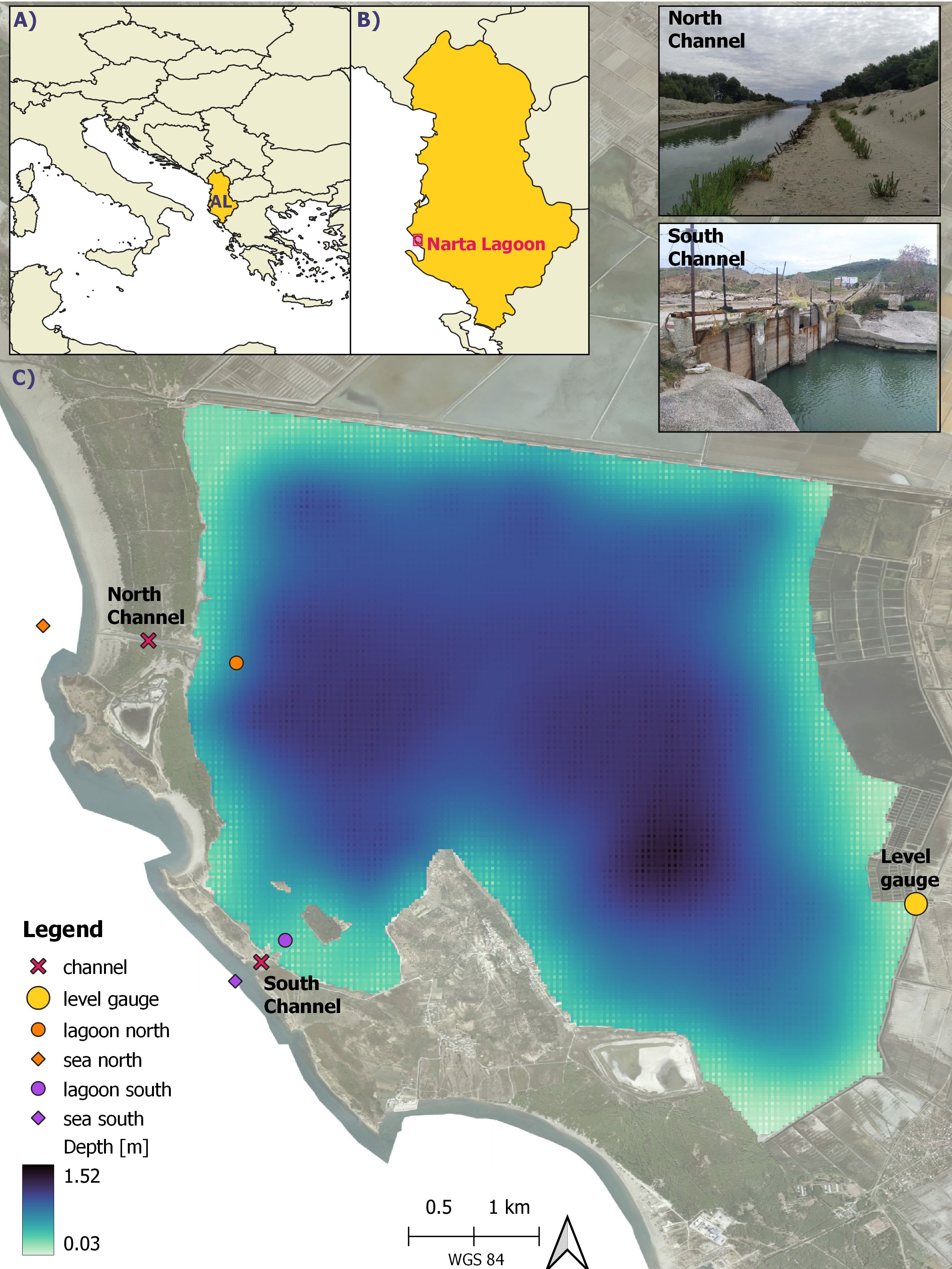
Figure 1. (A, B) Localization of Albania and Narta Lagoon; (C) Narta Lagoon bathymetry, localization of MeteOcean level gauge (yellow point) the north and south channels (red crosses) linking the lagoon with the Adriatic sea. In orange and purple, numerical monitoring station are reported where levels are monitored, while water discharge is monitored at crosses. The basemap is 2015 Ortophoto of Albania, available in the Albanian National Geoportal. On the upper side of the figure, pictures of the north and south channels are reported.
Despite its ecological and cultural significance, the Narta Lagoon is increasingly threatened by various anthropogenic pressures. These include the nearby municipal landfill serving Vlorë and surrounding towns, industrial activities such as salt production and leather tanning (see e.g., Kane et al., 2015; Çako et al., 2014; Beqaj, 2023; Vaso et al., 1996), illegal fishing practices (Topi et al., 2013), and the recent construction of a regional airport. Many of these activities are located in close proximity to the lagoon, and their associated wastewater is not always properly treated, raising concerns about contamination through surface runoff and groundwater leaching.
Previous water quality assessments have identified strong seasonal variability in salinity, hypersaline conditions in summer and salinity levels closer to those of the Adriatic Sea in winter, alongside a general tendency toward oligotrophic conditions and overall acceptable physico-chemical parameters (see e.g., Çomo et al., 2018; Topi et al., 2013; Kane et al., 2015).
At present, the exchange of water between the lagoon and the Adriatic Sea is primarily controlled by two main inlets, which differ significantly in geometry and operational management, as shown in Figure 1C. The southern channel (lon/lat: 19.395647/40.514683, WGS84) is approximately 200 meters long and has a minimum width of 10 meters. It is equipped with manually operated sluice gates located at its narrowest point. The northern channel (lon/lat: 19.379781/40.545369), in contrast, is longer (about 800 meters) and slightly wider (just over 10 meters), but it is subject to seasonal closure due to sediment accumulation from littoral transport. Local sources report that it is manually reopened by fishermen approximately twice a year (Topi et al., 2013).
The operation of these channels is largely unregulated and managed informally by local stakeholders, primarily fishermen. No consistent or scheduled procedures are in place for the opening and maintenance of the inlets. In addition, sediment deposition at the seaward ends of the channels, driven by wave-induced transport, further limits water exchange, often leading to stagnation and associated ecological stress.
2.2 Methodology framework
Studies on lagoon–sea connectivity range from simple water sampling campaigns (Newton and Mudge, 2005) to analytical approximations (Chubarenko and Zakirov, 2021) and the use of comprehensive numerical models (Bellafiore et al., 2008). In this study, we adopt a combined approach involving both field measurements and numerical modeling to assess the hydrodynamics of the Narta Lagoon. Field campaigns conducted between 2021 and 2022 provided key data on bathymetry and water level variability to support and validate the modeling effort.
Our approach is based on a selection of N representative met-ocean forcing conditions that capture the main drivers of the lagoon’s circulation while ensuring computational feasibility. This strategy aligns with similar methodologies adopted in previous studies focusing on coastal and estuarine systems (see e.g., Bárcena et al., 2016; He et al., 2024; Daliri et al., 2025).
These scenarios are used to force a three-dimensional hydrodynamic model to simulate the corresponding velocity fields and water level variability under different environmental conditions.
Following the hydrodynamic simulations, we analyze key physical metrics to characterize the lagoon’s response to external forcing. These include: (i) an energetic analysis of current fields, (ii) the temporal evolution of water levels at both ends of the inlet channels, (iii) the net water discharge between the lagoon and the sea, and
To further assess the lagoon’s capacity to retain or exchange water masses, a Lagrangian particle tracking model is implemented. Surface velocity fields from the hydrodynamic model are interpolated onto a high-resolution regular grid, and virtual particles are released throughout the lagoon to simulate passive tracer dispersion. The fate of these particles is tracked to identify their trajectories and quantify the proportion exiting the lagoon through the inlets.
The combination of Eulerian and Lagrangian diagnostics offers an integrated perspective on flushing dynamics, water retention, and the physical vulnerability of the system under different environmental scenarios.
Details on the data sources, selection of met-ocean scenarios, and model setup are provided in Section 2. Results are presented and discussed in Section 3 and 4, while the conclusions are outlined in Section 5.
All the activities were carried out within the framework of the project BLUE coAL-ITion: Eco-sustainable Development for Albanian coast-sea natural capita, funded by AICS Tirana.
2.3 Bathymetric surveys and water level measures
A bathymetric survey of the Narta Lagoon was conducted in October 2021 using a low-cost, portable sonar system (Deeper Smart Sonar CHIRP+; v1.deepersonar.com) in combination with high-precision GNSS-RTK positioning (as recently applied in Casella et al., 2024). The sonar device was mounted on a small fishing vessel, which followed pre-defined transects across the lagoon designed to maximize spatial coverage. Survey results revealed that the lagoon bathymetry is relatively homogeneous, with minimal bottom elevation variability. Over the majority of the lagoon, depths range between 1.0 and 1.5 meters, gradually decreasing toward the edges, and no significant morphological irregularities were observed (Figure 1C).
Next, in order to derive reliable measurements of the fluctuations in the lagoon’s water levels, we developed and installed a system made of a probe connected to a computer for data storage and transmission to a target webserver (www.hydrovjosa.eu). The probe was made by a mic+340/D/TC device (www.microsonic.de), an ultrasonic sensor that measures distances between 350 mm and 5 meters; depending on the sensing range, the resolution internal for distance measurement spans the 0.025 mm to 0.18 mm interval.
The system sampled the distance between the probe and the lagoon every half an hour during two minutes at 10 Hz frequency. The probe was connected to a Raspberry PI B+ that transferred the data to remote servers at the University of Genoa every day at 23:45 UTC and to the hydrovjosa project repository.
Measures were referred to the Geodetic Datum AL1986Gauss-Kruger Zone 4 by taking advantage of the GNSS-rtk satellite position tracking. The referenced water level was then computed by means of the following relation-ship by means of Equation 1:
where ηi and zi are the local water level with respect to the bottom and the distance sampled by the probe at the ith time, respectively; the subscript ic indicates the measures collected at the time when the probe was geo-referenced.
2.4 Selection of scenarios
To realistically force the hydrodynamic model of the Narta Lagoon, we selected representative wind and tidal scenarios based on a clustering analysis applied to long-term atmospheric data. Specifically, we employed a 40-year hindcast dataset of wind fields produced by the MeteoOcean research group at the University of Genoa (forecast.meteocean.science) (Cassola et al., 2015, 2016; Ferrari et al., 2020; Cavaleri et al., 2022). This hindcast provides hourly meteorological data at an approximate spatial resolution of 10 km, covering the entire Mediterranean basin.
After identifying the spatial node closest to the study area, we applied the Maximum Dissimilarity Algorithm (MDA) (Camus et al., 2011) to extract a subset of significant one-week-long wind scenarios. The goal of this procedure was to maximize the diversity of selected events by ensuring high dissimilarity among clusters, thereby capturing the full range of wind conditions that influence the lagoon’s hydrodynamics. Details on data pre-processing and clustering methodology can be found in Cremonini et al. (2021).
To determine the optimal number of scenarios, we performed a sensitivity analysis by evaluating the mean inter-centroid distance across a range of cluster numbers. This metric quantifies the average distance in feature space between the centroids of different clusters. As expected, the mean intercentroid distance decreases as the number of clusters increases, indicating diminished distinctiveness between groups. The ideal number of scenarios was identified at the “elbow” point of this curve, where further increases in cluster number resulted in marginal improvements, striking a balance between variability representation and computational feasibility.
Given the relatively low variability in the regional wind field, the objective selection was refined through expert judgment to ensure coverage of the most hydrodynamically relevant conditions. Ultimately, six one-week scenarios were selected to represent the most divergent and representative wind conditions within the dataset.
For each selected scenario, we further derived tidal forcing at the lagoon’s marine boundary using the TPXO Global Tidal Model version 7.2 (Egbert and Erofeeva, 2002). This model offers global coverage of tidal constituents and is widely used in hydrodynamic simulations of coastal and estuarine systems due to its reliability and resolution. The combined wind and tidal scenarios were thus used to drive the numerical model, providing a comprehensive representation of the main external forcings acting on the Narta Lagoon.
2.5 Numerical modeling of local hydrodynamic
The hydrodynamic simulations for this study were carried out using Delft3D (Lesser et al., 2004; Delft-Hydraulics, 2007), a process-based numerical model widely employed for simulating flow, sediment transport, and water quality in coastal and estuarine environments. The model was implemented in its fully three-dimensional (3D) configuration, with the vertical domain discretized using a sigma-layer approach. A total of seven vertical layers were defined, scaled proportionally to the local bathymetry to ensure accurate representation of vertical flow gradients throughout the computational domain.
The horizontal grid employed in the simulations featured a variable spatial resolution, ranging from 30 meters in the central lagoon to 10 meters in the narrower channel areas, allowing for a refined description of the hydrodynamic processes in regions of complex geometry and flow patterns.
Model forcing was based on the set of representative met-ocean scenarios described in Section 2.4, designed to capture the variability of local wind regimes and tidal dynamics. For each selected scenario, wind fields were applied uniformly across the domain, while tidal oscillations were imposed along the western open boundary, representing the connection with the Adriatic Sea.
To simulate turbulence, the standard k–ϵ closure scheme was adopted, which is commonly used in coastal applications due to its robustness and efficiency. A time step of 2.4 seconds was selected to maintain numerical stability across the simulations. Additionally, a 12-hour spin-up period was included at the beginning of each model run to allow for the stabilization of the initial flow and to minimize the influence of transient initialization effects.
2.6 Dispersion modeling
To complement the hydrodynamic analysis, an additional set of simulations was conducted to investigate particle dispersion within the Narta Lagoon using a Lagrangian Particle Tracking Model implemented with the OceanParcels framework (Lange and van Sebille, 2023). This model allows for the simulation of passive tracer trajectories driven by time-evolving velocity fields derived from hydrodynamic models.
The velocity outputs from the Delft3D simulations were interpolated onto a regular grid with 4-meter resolution, providing enhanced spatial detail in critical areas such as the lagoon’s narrow channels. This downscaling ensured that small-scale transport processes, particularly in the inlet regions, were better resolved in the particle tracking phase.
To account for sub-grid scale turbulence, which is not explicitly resolved in the Eulerian velocity fields, the Smagorinsky parameterization was applied within the advection-diffusion equation. A Smagorinsky constant of 0.3 was used, providing a realistic representation of turbulent diffusion without allowing particles to artificially jump across distant grid cells.
The integration time step for the particle tracking was set to 20 seconds, representing a compromise between computational efficiency and numerical stability. A no-slip condition was imposed at the model boundaries, such that particles reaching the coastline remained stationary, thereby mimicking realistic shoreline retention effects.
This modeling approach allowed us to assess the spatial and temporal evolution of tracer dispersion under the influence of different hydrodynamic scenarios, offering valuable insights into water renewal, stagnation zones, and the connectivity of various subregions within the lagoon.
3 Results
In this section, we present the results obtained from the hydrodynamic simulations and field observations, focusing on the circulation patterns inside the Narta Lagoon under varying met-ocean forcing and inlet configurations. The goal is to assess the lagoon’s capacity for water renewal and exchange with the sea, thereby gaining insight into the physical processes controlling the transport and dispersion of potential pollutants and nutrients within the system.
3.1 Hydrometric analysis
Water levels within the lagoon were continuously monitored from October 2021 to July 2022 (Figure 2a). The measurement system was eventually decommissioned due to persistent technical issues related to energy supply at the hosting station.

Figure 2. (a) Time series of observed water levels in the Narta Lagoon. (b) High-pass filtered signal isolating short-term variability. The highlighted segment was selected for autocorrelation analysis.
To isolate possible oscillations associated with tidal forcing, the raw signal was first cleaned by removing spurious spikes and then subjected to a two day low-pass filter, following recommendations from Ray and Foster (2016). The filtered series, shown in Figure 2b, highlights key trends in lagoon levels over the observation period. A pronounced rise occurred in December 2021, with water levels increasing by nearly 40 cm (from 1.15 m to 1.55 m) due to intense regional precipitation. This was followed by a gradual return to baseline conditions by February 2022. Conversely, a sharp decline in water levels occurred starting in March 2022, attributed to the temporary opening of the lagoon inlets, with a recorded minimum in April. After the inlets were closed again, levels rose to approximately 1.0 m, with subsequent fluctuations likely driven by seasonal evaporation and sporadic rainfall during the transition to warmer months.
To explore the potential influence of tidal signals on the water level dynamics, we conducted an autocorrelation analysis (ACF) on the residual high-frequency signal (Figure 2b). The ACF quantifies the degree of similarity between the time series and lagged versions of itself and is commonly employed to detect cyclic patterns, such as those arising from tidal forcing (e.g., Ze-Guo Zhang and Liu, 2018; Kareem et al., 2022).
Given the mixed semi-diurnal tidal regime of the Adriatic Sea (Guarnieri et al., 2013), significant autocorrelation at 12-hour intervals (or multiples thereof) would be expected if tidal influence were effectively transmitted into the lagoon. However, as illustrated in Figure 3 (right panel), no such periodic signal was identified within any uninterrupted subset of the lagoon’s water level data. For comparison, the autocorrelation of the open-sea tide (left panel) shows a clear semi-diurnal signature.
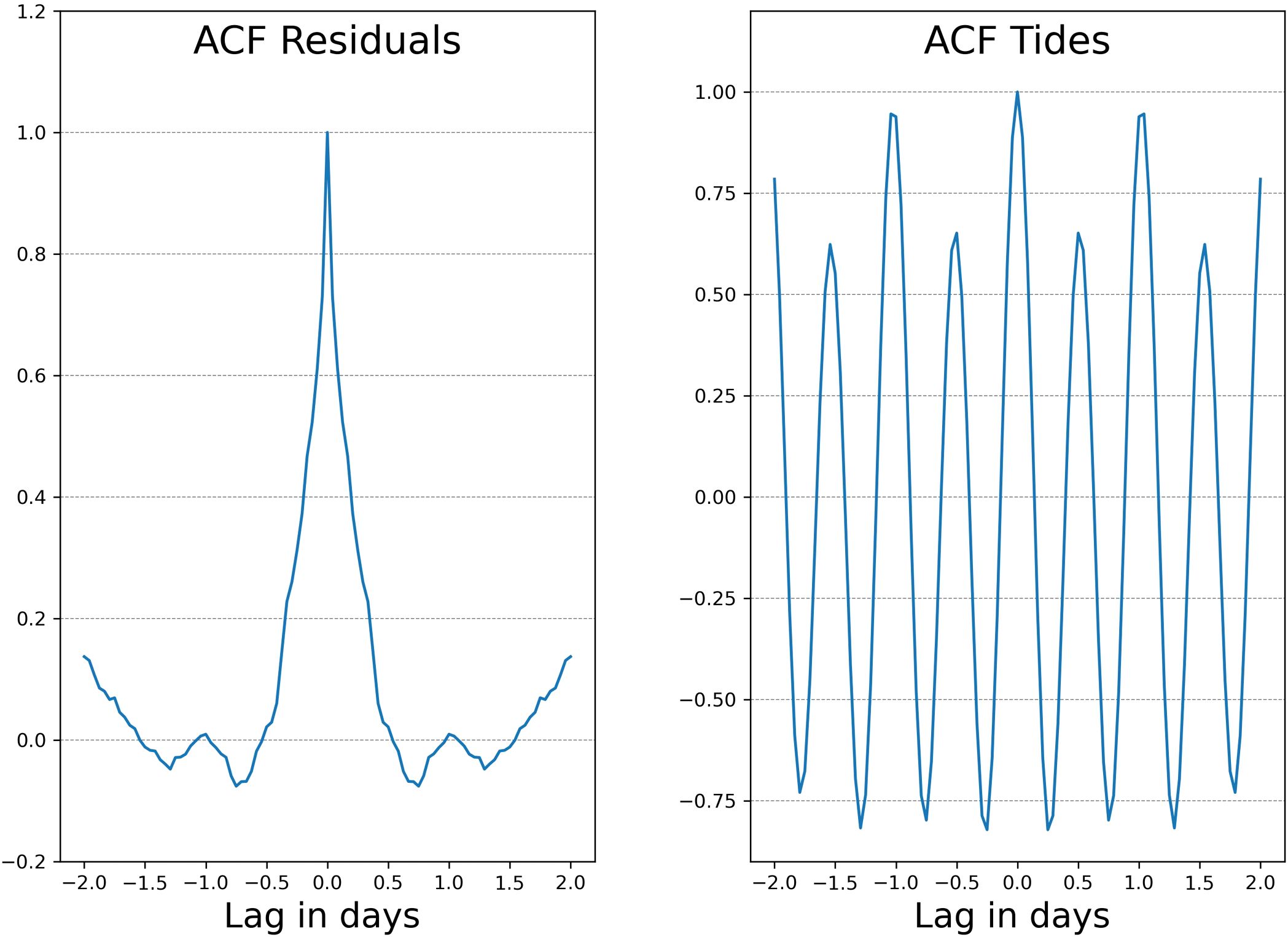
Figure 3. Autocorrelation functions (ACFs) for (left) sea-level data along the Vlorë coast, and (right) residual water levels inside the Narta Lagoon. The absence of periodicity in the lagoon signal suggests weak tidal influence.
This lack of detectable tidal periodicity suggests two possible scenarios: (i) tidal energy is not transmitted into the lagoon due to the closure or restriction of the connecting channels, or (ii) the strong bottom friction and shallow depths within the lagoon attenuate the tidal signal before it can propagate inward. Given the relatively small mean tidal range (30 cm), characteristic of a microtidal system, and the known channel configurations (Section 2.1), the results point toward limited hydrological exchange between the lagoon and the Adriatic Sea. These observations provide a strong rationale for the numerical modeling approach discussed in subsequent sections.
3.2 Selection of scenarios
The selected wind and tidal forcing conditions used to drive the hydrodynamic model are illustrated in Figures 4, 5, which show wind rose diagrams and time series of tidal elevation, respectively, for each of the six representative scenarios.
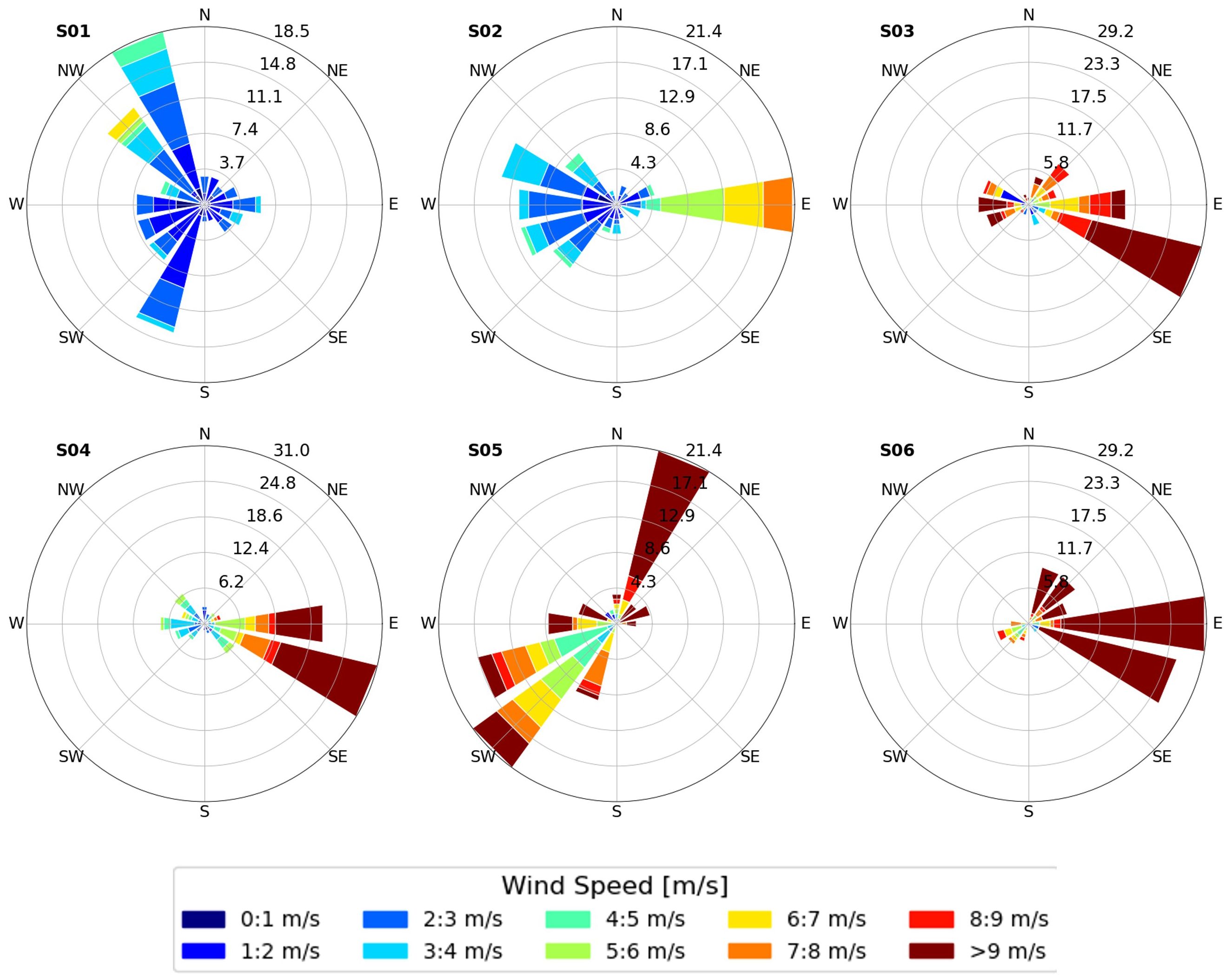
Figure 4. Rose plot for the wind used as forcing, for the six scenarios analyzed.
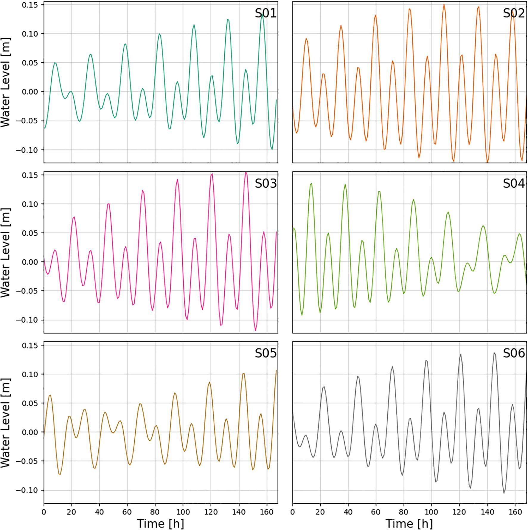
Figure 5. Tidal forcing signal at the seaside boundary of the model for the selected meteocean scenarios.
Scenarios 02, 03, 04, and 06 are characterized by easterly to southeasterly winds, while scenarios 01 and 05 display prevailing northwesterly to southwesterly winds. Given the geographic orientation of the Narta Lagoon, where both inlets are located on the western shoreline, winds from the east-southeast are expected to enhance outflows from the lagoon toward the Adriatic Sea. Conversely, winds from the west and northwest are likely to promote inflows into the lagoon, pushing marine water inward through the channels.
The tidal forcing, reconstructed using the TPXO global tide model, exhibits a mixed semi-diurnal regime, consistent with regional oceanographic conditions along the Albanian coast. The typical tidal range does not exceed 30 cm, placing the system within the microtidal classification. As such, the tidal contribution to lagoon flushing is relatively weak. This further highlights the dominant role of wind stress in driving circulation, water renewal, and dispersion dynamics within the lagoon.
These insights provide essential context for interpreting the model results and analyzing the relative impacts of wind and tidal forces on hydrodynamic behavior and pollutant transport.
3.3 Numerical simulation of Narta Lagoon hydrodynamics
The hydrodynamic response of the Narta Lagoon was evaluated by analyzing the time-averaged velocity fields at the surface and bottom layers over the duration of each one-week scenario. These simulations represent the combined effects of wind and tidal forcing on the lagoon circulation. The objective was to characterize prevailing flow patterns and assess the system’s capacity for water renewal and transport processes under different environmental conditions (Figures 6, 7).
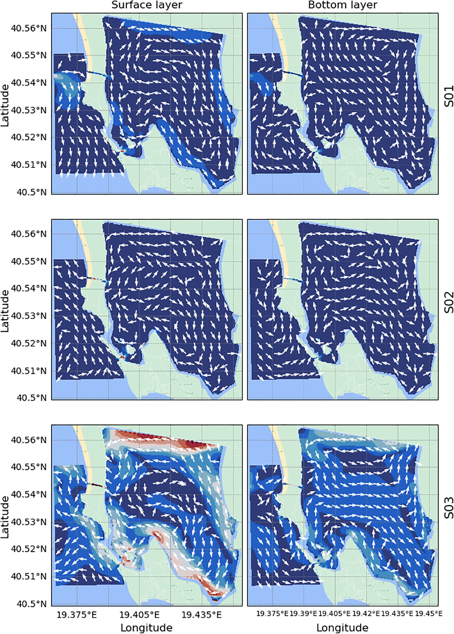
Figure 6. Weekly-averaged velocity fields in the Narta Lagoon: surface layer (left) and bottom layer (right) for scenarios 01, 02, and 03.
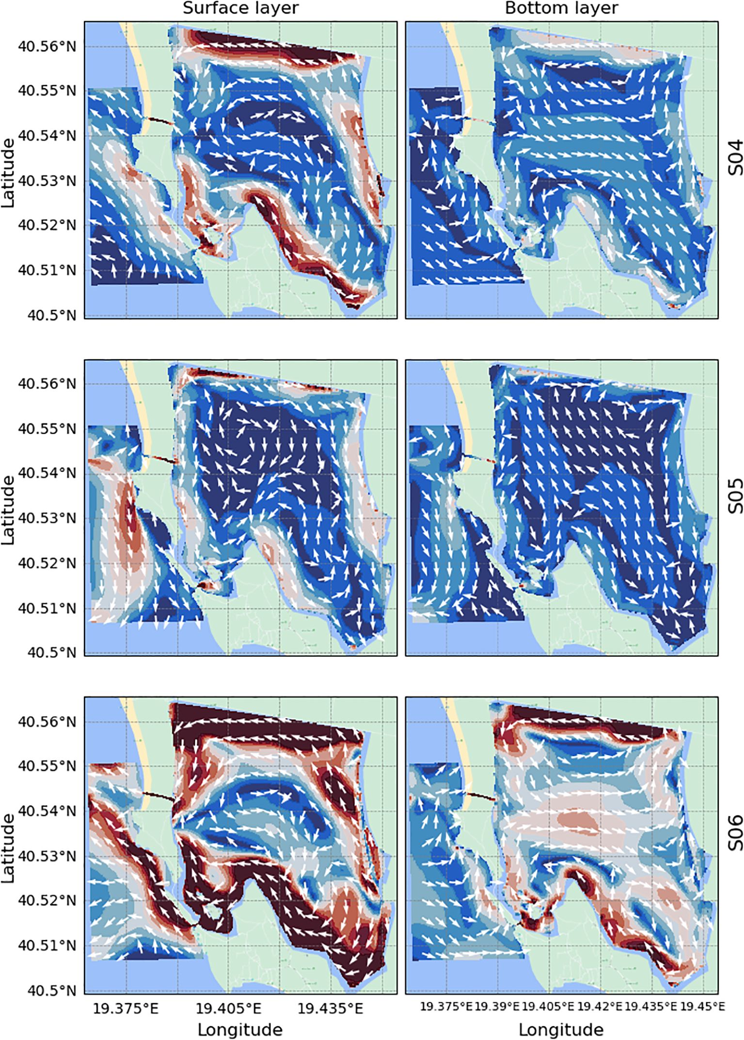
Figure 7. Weekly-averaged velocity fields in the Narta Lagoon: surface layer (left) and bottom layer (right) for scenarios 04, 05, and 06.
Analysis of the surface velocities (left panels) reveals that circulation patterns are strongly influenced by wind direction and intensity. Enhanced velocities are typically observed along the northern boundary of the lagoon, although circulation within the interior does not show persistent large-scale flow structures. Instead, currents generally align with the lagoon boundaries, but no coherent or recurring directional pattern is observed, likely due to the variability in the wind forcing across the scenarios.
At the bottom layer (right panels), no clear counter-rotating structures relative to the surface flow are observed. However, this does not imply the absence of vertical shear in the system. Instead, the result is likely influenced by the weekly averaging applied to the velocity fields, which tends to smooth out transient features. Therefore, the largely homogeneous patterns shown in the averaged fields likely reflect the dominant directionality over the week, rather than the full complexity of the flow dynamics.
In the central lagoon, several simulations suggest the formation of eddies—localized rotating structures that may contribute to water retention and mixing. To quantify these features, the Okubo-Weiss parameter (W) was calculated, following the methodology of Chang and Oey (2014). Regions where W< 0 were identified as vortical zones, where vorticity dominates over strain deformation. From this, two eddy characteristics were derived: the vortex energy (Equation 2) and eddy occupation (Equation 3).
The vortex energy, defined as:
measures the intensity of circulation within the vortical area, where Aeddyis the area of the grid cells (M) which satisfies the W< 0 condition. The corresponding eddy occupation quantifies the fraction of the lagoon covered by such vortical structures:
where Atotalis the full surface area of the computational domain.
As shown in Figure 8, vortex energy increases progressively from scenario 01 to scenario 06, consistent with the velocity field results, which display more energetic flow under stronger or more coherent wind conditions in the latter scenarios. In addition, each scenario exhibits substantial temporal variability, with alternating phases of high and low vortex energy. This indicates that the eddies are short-lived, typically forming and dissipating within time scales of approximately 24 hours. This transient behavior highlights the dynamic nature of the lagoon’s hydrodynamics and the influence of wind variability on eddy development.
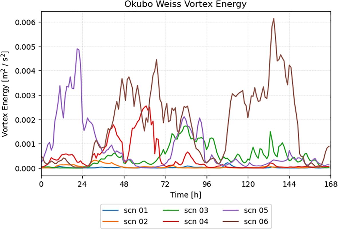
Figure 8. Time evolution of the Okubo-Weiss vortex energy.
Interestingly, the spatial coverage of eddies (Figure 9) shows no clear correlation with the vortex energy. In fact, scenarios with high vortex energy do not necessarily correspond to larger eddy-covered areas, suggesting that stronger eddies may be more compact, while weaker but spatially extensive structures may appear under calmer conditions. This decoupling between eddy energy and spatial occupation underscores the complexity of the flow patterns and further supports the need for localized and time-resolved analysis of lagoon dynamics.

Figure 9. Okubo-Weiss occupation factor in time for scenario 01, 02, 03 (top panel) and scenario 04, 05, 06 (bottom panel).
3.4 Water exchange between the lagoon and the sea
To evaluate the capacity of the Narta Lagoon to renew its waters and maintain acceptable water quality, we conducted two complementary analyses. The first assesses the influence of tidal forcing on lagoon hydrodynamics by analyzing water level variations, while the second quantifies the water exchange through the inlets, thereby evaluating the degree of connectivity with the Adriatic Sea and the relative importance of wind-driven dynamics.
Water level outputs from the hydrodynamic model were extracted at both ends of the lagoon’s inlets—that is, from locations within the lagoon and at their seaward boundaries (Figure 1C). The resulting time series, shown in Figure 10, reveal a marked lack of correlation between internal and external water level fluctuations. Tidal oscillations are barely discernible during scenarios characterized by mild wind conditions, and they completely vanish in the most energetic scenarios (05 and 06). This pattern confirms that tidal signals from the open sea are not effectively transmitted into the lagoon, further supporting the hypothesis of poor hydraulic connectivity through the existing inlets.
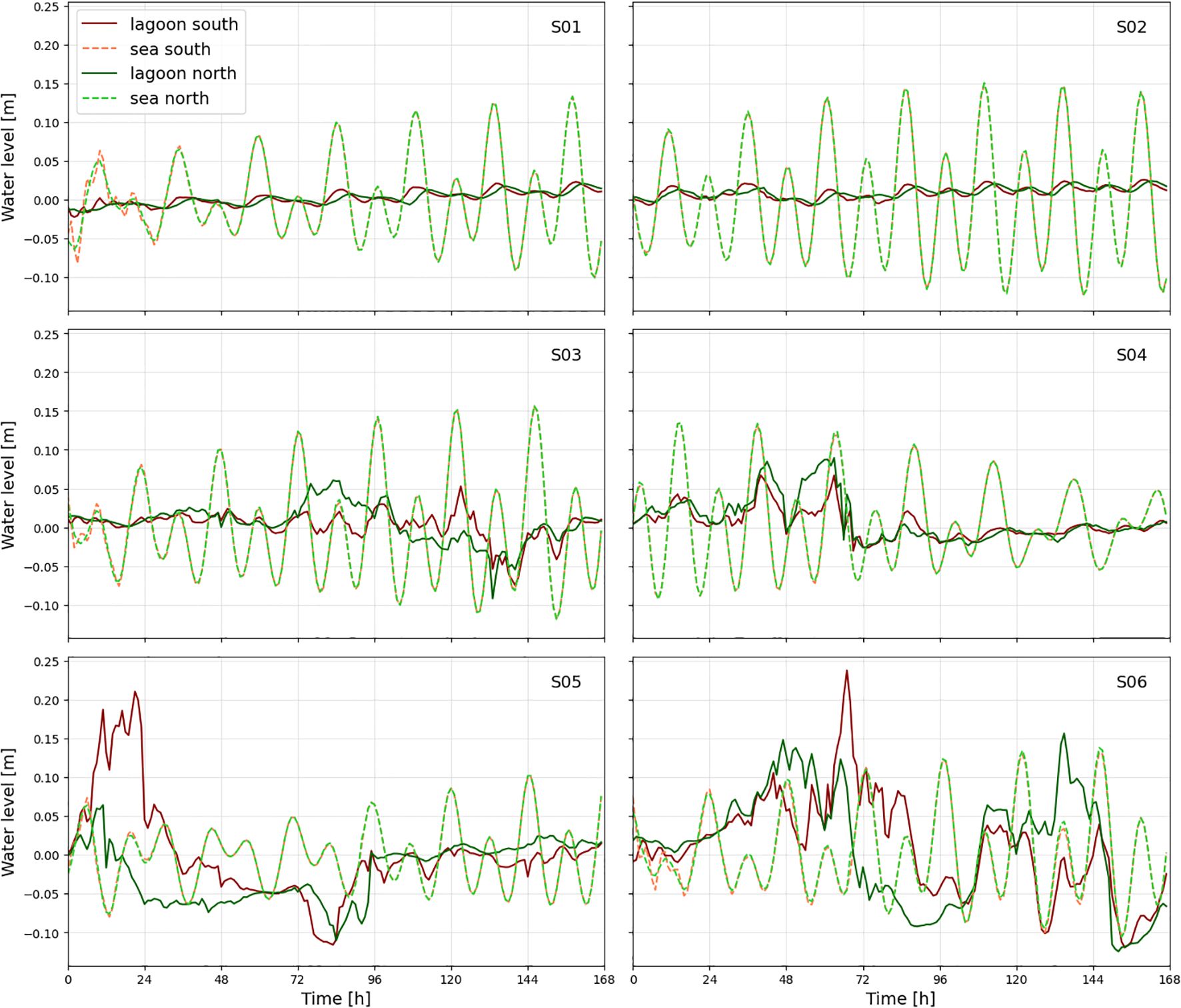
Figure 10. Simulated water level time series at the sea-lagoon interface for different scenarios. Dashed line: open-sea side; continuous line: inner-lagoon side. Green lines: north channel; red lines: south channel.
The analysis of water discharge through the inlets (Figure 11) provides quantitative confirmation of these findings. The net water exchange across all scenarios remains limited, ranging from -2% (net outflow from the lagoon) to +0.6% (net inflow). These values are summarized in Table 1. Negative exchange rates are predominantly associated with scenarios featuring easterly winds, which promote lagoon outflow, whereas positive exchange is occasionally observed under opposing wind conditions. Importantly, the tidal signal, detectable in low-energy scenarios, disappears entirely under strong wind forcing, suggesting that wind stress dominates the exchange dynamics in such conditions.
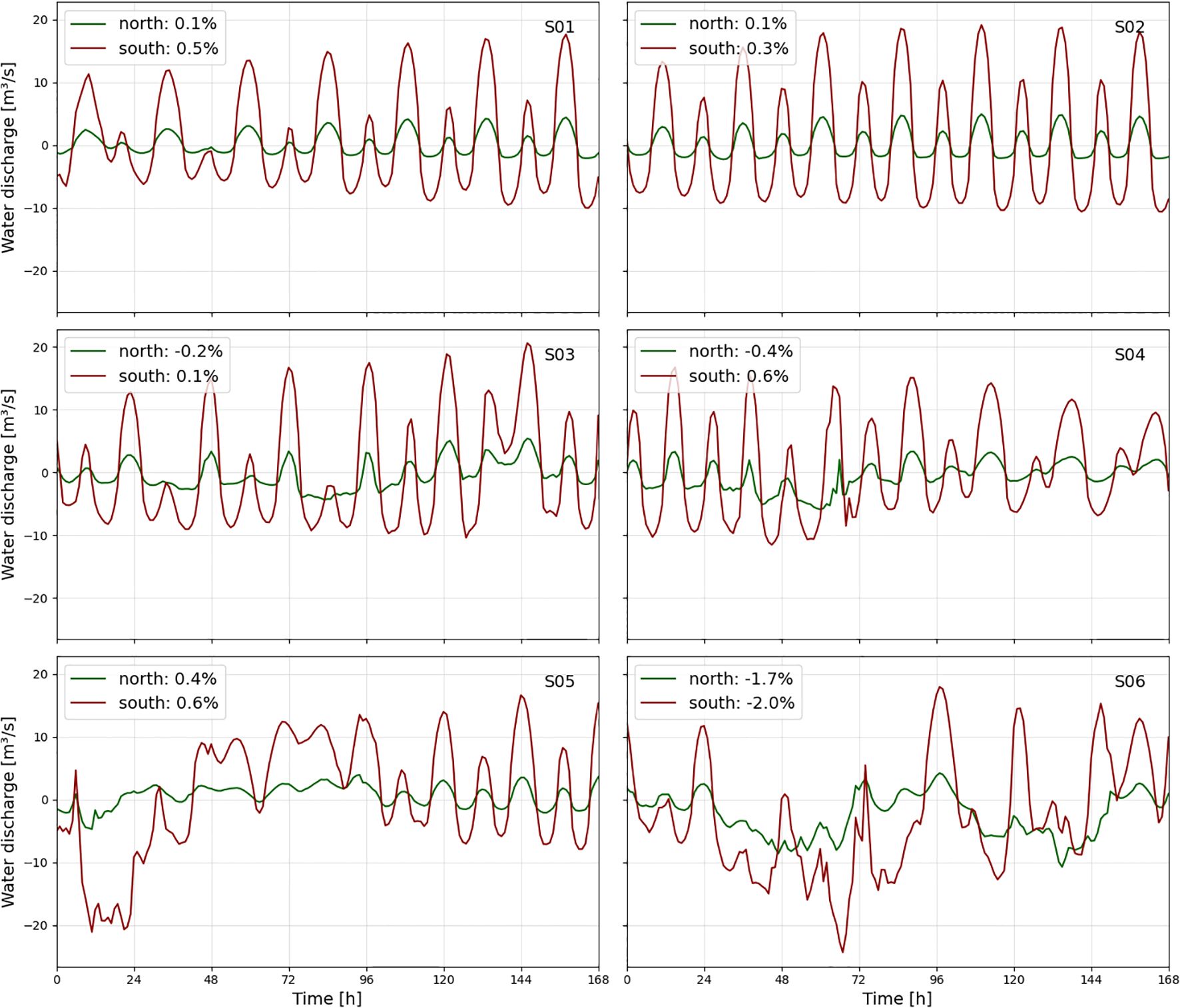
Figure 11. Net water discharge through the lagoon inlets for each scenario.
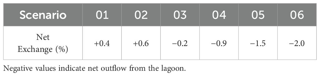
Table 1. Summary of net water exchange for each metocean scenario.
These findings reinforce the conclusions drawn from both field observations and modeling: the hydraulic isolation of the lagoon, exacerbated by sedimentation and artificial closure of the inlets, results in limited water renewal and poses a risk to water quality and ecosystem health. Moreover, they highlight the dominant role of wind over tides in driving hydrodynamic processes in this shallow and microtidal environment.
3.5 The dynamics of dispersion in the Narta Lagoon
To investigate the capacity of the Narta Lagoon to exchange water and transport substances such as nutrients or contaminants, a series of particle tracking simulations was performed. Approximately 26,000 virtual particles were uniformly seeded throughout the lagoon, following a regular spatial grid with 30-meter spacing. The particle trajectories were computed using the velocity fields from the hydrodynamic model under each of the six metocean scenarios, and the number of particles exiting the lagoon through the northern and southern inlets was recorded.
Particles’ trajectories are shown in Figure 12, along with the exit rates which range from 0.2% to 1.5% (see also Table 2). Interestingly, most particles exited the lagoon through the northern channel, despite its being longer and narrower than the southern one. This counterintuitive result is primarily attributed to the presence of islands sheltering the southern channel, which act as physical barriers, redirecting and obstructing particle pathways. For those scenarios where particles do exit through the southern inlet (e.g., scenarios 01, 02, 03, and 05), their origins are predominantly confined to the area between the islands and the coastal barrier separating the lagoon from the open sea. Only in scenario 03 do a small number of particles originate from the eastern side of the islands. This indicates that the islands significantly limit connectivity with the southern channel, reducing the effective exchange through that outlet.
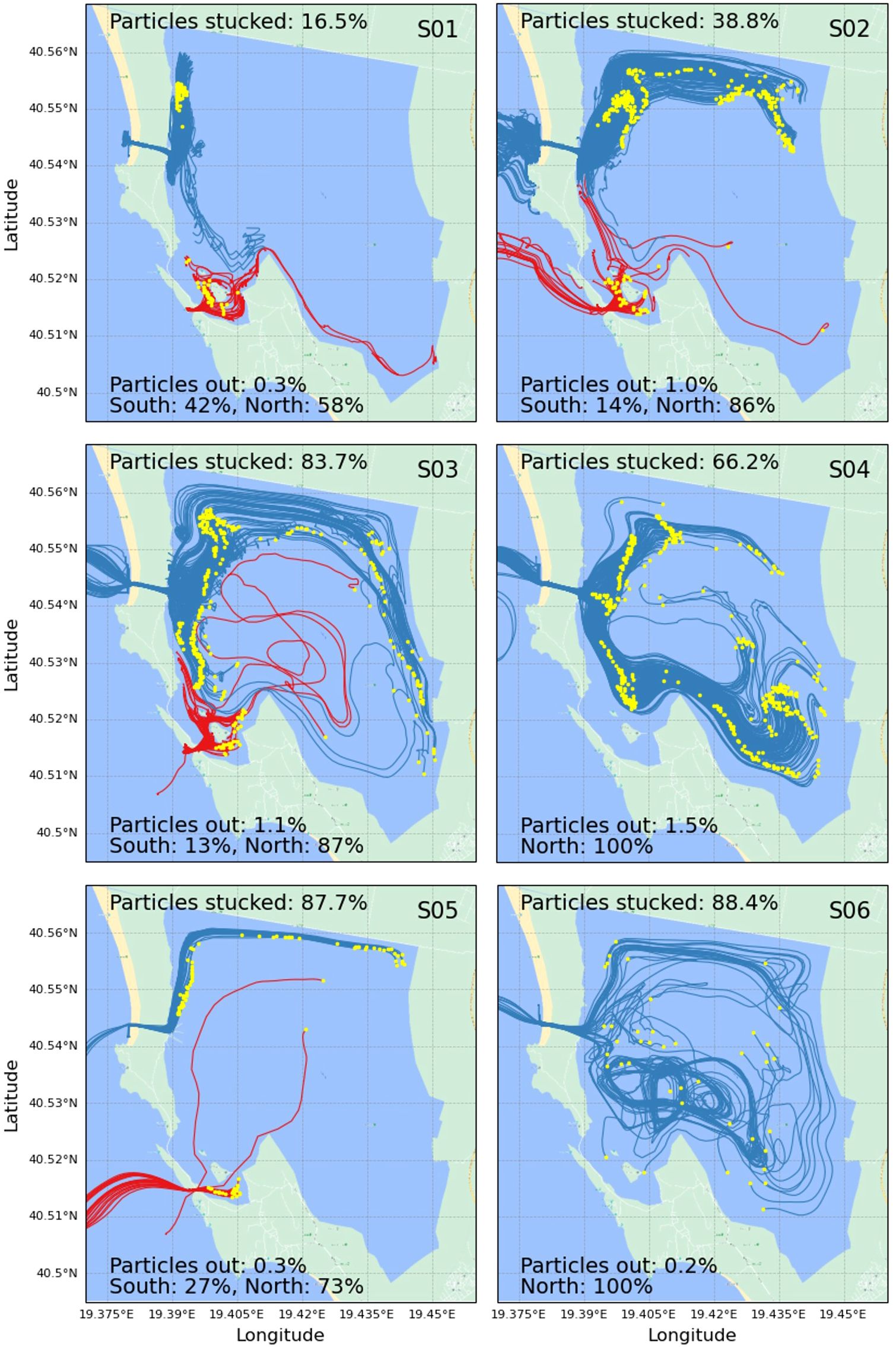
Figure 12. Trajectories of particles leaving the lagoon through North (blue) and South channels (red). Yellow dots indicate releasing positions.
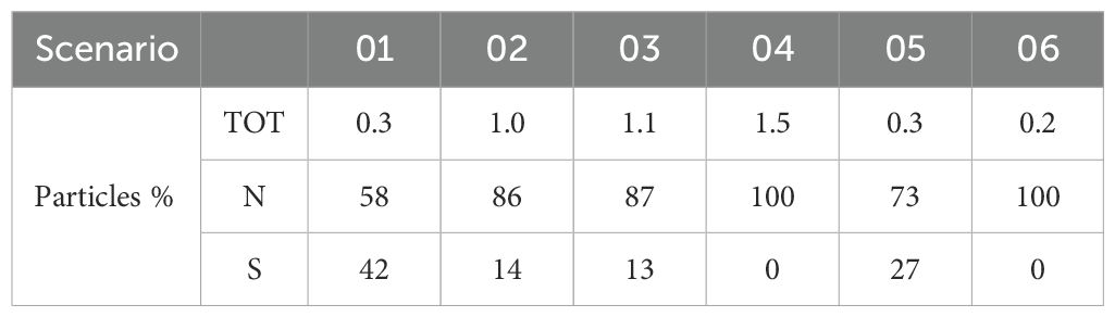
Table 2. Percentage of particle’s exchange between the sea and the lagoon (TOT) and through the two channels (N and S) for the different metocean scenarios.
Additionally, in several scenarios (e.g., 02, 03, 04, and 05), the particles that eventually left the lagoon tended to be released near the boundaries, rather than from the central basin. This pattern appears to result from a “conveyor belt” effect, where higher current velocities and peripheral circulation patterns—often in the form of clockwise or counterclockwise eddies—transport particles along the margins of the lagoon toward the inlets.
In lower-energy scenarios (e.g., 01, 02), particles that successfully exit the lagoon typically originate close to the inlets, due to reduced overall circulation and weaker mixing. Conversely, in more energetic scenarios (e.g., 06), particles may exit from more interior locations, indicating enhanced dispersion and connectivity due to stronger circulation. However, this trend is not linear: in scenario 06, despite high average velocities and easterly wind forcing (favorable for outflow), the exit rate drops to just 0.2%. This deviation may be explained by increased recirculation, stronger eddy activity, or localized flow patterns near the channels that inhibit particle escape under such conditions.
Finally, the proportion of stuck particles, those that remain indefinitely within the lagoon, tends to increase with scenario energy. This is clearly visible in Figure 12, where more energetic wind scenarios are associated with higher numbers of retained particles. These results emphasize the nonlinear relationship between wind forcing and flushing efficiency, and highlight how local morphology and small-scale circulation features critically shape the lagoon’s dispersive behavior.
4 Discussion
Understanding the water exchange between the Narta Lagoon and the Adriatic Sea is fundamental to evaluating the lagoon’s hydrodynamics and, by extension, the health of its ecosystem. Water exchange is a key driver of water quality, facilitating the removal of excess nutrients, pollutants, and suspended matter. These processes are critical for maintaining the ecological balance that supports the lagoon’s diverse bird, fish, and aquatic communities.
In this study, both field observations and numerical simulations were used to assess the lagoon’s renewal capacity. The analysis of water level correlations between the inner lagoon and the open sea showed that tidal signals are barely transmitted into the lagoon (Section 3.4), suggesting that tidal forcing plays a minor role in the lagoon’s internal circulation. This decoupling from the sea is further complicated by the presence of manually operated sluice gates, which lack a defined opening schedule and act as a barrier to regular exchange.
Numerical simulations considering the channels to be fully open revealed that water exchange remains limited even under idealized connectivity conditions. Both the low discharge rates and the restricted particle export observed across multiple scenarios (Section 3.5) point to a highly retentive system. This raises significant concerns about the vulnerability of the lagoon to water quality degradation, particularly in the event of contaminant or nutrient inputs.
These hydrodynamic features have clear ecological implications, which align with observations in other Mediterranean lagoon systems. The limited water exchange observed in the Narta Lagoon implies long residence times for nutrients and contaminants, which can promote eutrophic conditions. In such systems, elevated nutrient concentrations, particularly nitrogen and phosphorus, can trigger excessive primary production, often resulting in harmful algal blooms. These blooms deplete oxygen in the water column during decomposition phases, leading to hypoxic or anoxic conditions detrimental to fish and benthic fauna (e.g., Kane et al., 2015; Jones et al., 2024). Moreover, limited flushing reduces the system’s capacity to recover from pollution events, increasing its ecological sensitivity to seasonal runoff or sewage inputs. These processes may result in habitat degradation, biodiversity loss, and the disruption of migratory bird routes and spawning grounds.
The patterns observed in Narta are consistent with findings in other Mediterranean lagoons exhibiting low tidal ranges and restricted inlets. For instance, the Mar Menor in Spain has experienced severe eutrophication due to nutrient accumulation from agricultural runoff and limited water renewal, leading to substantial ecological degradation (García-Pintado et al., 2007). Similarly, the Venice Lagoon in Italy, despite its larger size and multiple inlets, faces challenges with water quality and habitat loss, exacerbated by anthropogenic pressures (Sarretta et al., 2010). In contrast, lagoons like the Étang de Thau in France and the Orbetello Lagoon in Italy, which benefit from more effective water exchange mechanisms, have demonstrated greater resilience to nutrient loading and better maintenance of ecological balance (Zannella et al., 2007; Derolez et al., 2020). These comparisons emphasize the importance of hydrodynamic connectivity in sustaining lagoon health and resilience.
The findings of this study emphasize the fragile equilibrium that characterizes the Narta Lagoon. Without sufficient flushing and with irregular channel management, the lagoon is especially sensitive to external pressures. This underscores the urgent need for improved monitoring, consistent management practices, and protective policies aimed at preserving the ecological function and services of the lagoon.
While this study provides new insights into the hydrodynamic functioning of the Narta Lagoon, some limitations must be acknowledged. First, the wind forcing used to drive the model was extracted from a hindcast node located offshore in the Adriatic Sea (2.4). As such, it may not fully capture the fine-scale variability induced by local orographic features, such as the small islands within the lagoon and the coastal dunes separating it from the sea. However, given the limited size and elevation of these features, their influence on the overall wind field is expected to be minor, and the offshore data likely provide a reasonable approximation of the dominant wind patterns affecting the lagoon. Moreover, the present modeling effort has not yet undergone validation against in situ velocity or flow measurements, which would be essential to fully assess the accuracy of the simulated circulation fields and particle trajectories. Another limitation is the absence of salinity-driven density gradients in the model. This barotropic approximation neglects baroclinic effects, which can play a significant role in vertical stratification and water exchange, especially under high evaporation conditions (Kankara and Panda, 2020; Huang et al., 2020). Additionally, the inlet configurations in the simulations assume idealized open channels, whereas in reality, the sluice gates and sedimentation processes cause partial or intermittent closure, which likely reduces the actual water exchange. Despite these limitations, the modeling framework presented here offers a robust baseline for understanding key hydrodynamic processes and sets the stage for more detailed and validated future studies.
5 Conclusions
This study assessed the hydrodynamic behavior and water exchange capacity of the Narta Lagoon, a vulnerable coastal system in southern Albania. Through a combination of field measurements and three-dimensional numerical modeling, we found that the lagoon exhibits extremely limited connectivity with the Adriatic Sea. Tidal signals were barely transmitted into the lagoon, and water renewal appeared to be primarily driven by wind stress. Simulations revealed very low flushing rates, with the majority of particles remaining trapped within the lagoon, particularly under high-energy wind scenarios.
These findings indicate a system highly prone to pollutant retention and water quality degradation, especially in light of current anthropogenic pressures such as irregular sluice gate operations and untreated urban discharges. The lagoon’s ecological balance, and with it, the sustainability of local livelihoods, depends critically on its ability to renew and exchange water with the sea.
To support the conservation of this delicate ecosystem, we recommend not only improved inlet management, including scheduled and ecologically informed operation of sluice gates, but also the restoration or optimization of channel morphology to enhance natural water exchange. Establishing a long-term monitoring network for water levels, salinity, and nutrient concentrations would enable better detection of critical trends and events, especially during dry seasons or high tourist activity. Regulation of pollutant inputs, particularly from untreated urban wastewater, should be prioritized through enhanced wastewater treatment and runoff management strategies.
From a research perspective, future modeling efforts should incorporate baroclinic processes, including salinity gradients and seasonal stratification, as well as biogeochemical modules to simulate nutrient cycling and oxygen dynamics. Additionally, model validation with targeted field measurements of currents, salinity, and pollutant concentrations is essential to reduce uncertainty and improve predictive capacity. Expanding the temporal scale of simulations to capture seasonal and interannual variability would further enhance understanding of the lagoon’s resilience and support adaptive management under changing climatic and anthropogenic conditions.
Data availability statement
The raw data supporting the conclusions of this article will be made available by the authors, without undue reservation.
Author contributions
MS: Writing – original draft, Software, Visualization, Validation, Investigation. FD: Investigation, Writing – review & editing, Visualization, Formal Analysis. LM: Data curation, Writing – review & editing, Investigation. MC: Data curation, Investigation, Writing – review & editing. GB: Writing – review & editing, Funding acquisition, Resources, Conceptualization.
Funding
The author(s) declare that financial support was received for the research and/or publication of this article. This research has been funded by CELIM (Centro Laici Italiani per le Missioni ONLUS) within “BLUE coAL-ITion: Eco-sustainable Development for Albanian coast-sea natural capital” project (Lot2: CIG 8136669FA8). Authors would like to thanks AICS Tirana (Agenzia Italiana per la Cooperazione allo Sviluppo) for the support during the field campaign.
Conflict of interest
Author LM was employed by Geoscape Cooperative Company.
The remaining authors declare that the research was conducted in the absence of any commercial or financial relationships that could be construed as a potential conflict of interest.
Generative AI statement
The author(s) declare that no Generative AI was used in the creation of this manuscript.
Publisher’s note
All claims expressed in this article are solely those of the authors and do not necessarily represent those of their affiliated organizations, or those of the publisher, the editors and the reviewers. Any product that may be evaluated in this article, or claim that may be made by its manufacturer, is not guaranteed or endorsed by the publisher.
References
Alba J. G., Gómez A. G., del Barrio Fernández P., Gómez A. G., and Álvarez Díaz C. (2014). Hydrodynamic modelling of a regulated Mediterranean coastal lagoon, the Albufera of Valencia (Spain). J. Hydroinformatics 16, 1062–1076. doi: 10.2166/hydro.2014.071
Bárcena J. F., García-Alba J., García A., and Álvarez C. (2016). Analysis of stratification patterns in river-influenced mesotidal and macrotidal estuaries using 3d hydrodynamic modelling and k-means clustering. Estuarine Coastal Shelf Sci. 181, 1–13. doi: 10.1016/j.ecss.2016.08.005
Bellafiore D., Umgiesser G., and Cucco A. (2008). Modeling the water exchanges between the venice lagoon and the adriatic sea. Ocean Dynamics 58, 397–413. doi: 10.1007/s10236-008-0152-7
Beqaj B. (2023). Evaluation of water quality parameters for narta lagoon. Eur. J. Eng. Technol. Res. 8, 41–45. doi: 10.24018/ejeng.2023.8.1.2945
Çako V., Zhuri E., Babani F., and Karaja T. (2014). Water transparency as one as of trophic state indices in narta lagoon. J. Eng. 04. doi: 10.9790/3021-04471522
Camus P., Mendez F. J., Medina R., and Cofiño A. S. (2011). Analysis of clustering and selection algorithms for the study of multivariate wave climate. Coastal Eng. 58, 453–462. doi: 10.1016/j.coastaleng.2011.02.003
Casella E., Scicchitano G., and Rovere A. (2024). Accuracy and precision of shallow-water photogrammetry from the sea surface. Remote Sens. 16. doi: 10.3390/rs16224321
Cassola F., Ferrari F., and Mazzino A. (2015). Numerical simulations of Mediterranean heavy precipitation events with the WRF model: analysis of the sensitivity to resolution and microphysics parameterization schemes. Atmospheric Res. 164-165, 210–225. doi: 10.1016/j.atmosres.2015.05.010
Cassola F., Ferrari F., Mazzino A., and Miglietta M. (2016). The role of the sea on the flash floods events over Liguria (northwestern Italy). Geophysical Res. Lett. 43, 3534–3542. doi: 10.1002/2016GL068265
Cavaleri L., Barbariol F., Bertotti L., Besio G., and Ferrari F. (2022). The 29 october 2018 storm in northern Italy: Its multiple actions in the ligurian sea. Prog. Oceanography 201, 102715. doi: 10.1016/j.pocean.2021.102715
Chang Y. L. and Oey L. Y. (2014). Analysis of stcc eddies using the okubo–weiss parameter on model and satellite data. Ocean Dynamics 64, 259–271. doi: 10.1007/s10236-013-0680-7
Chubarenko B. and Zakirov R. (2021). Water exchange of nontidal estuarine coastal vistula lagoon with the baltic sea. J. waterway port coastal ocean Eng. 147, 05021005. doi: 10.1061/(ASCE)WW.1943-5460.0000633
Çomo E., Hasimi A., Myrtaj B., and Mal Lushaj B. (2018). Evaluation of phisic-chemical features of the main coastal lagoons of narta and karavasta, in alabania. Online Int. Interdiscip. Res. J. 08.
Cremonini G., De Leo F., Stocchino A., and Besio G. (2021). On the selection of time-varying scenarios of wind and ocean waves: Methodologies and applications in the north tyrrhenian sea. Ocean Modelling 163, 101819. doi: 10.1016/j.ocemod.2021.101819
Cullaj A., Hasko A., Miho A., Schanz F., Brandl H., and Bachofen R. (2005). The quality of Albanian natural waters and the human impact. Environ. Int. 31, 133–146. doi: 10.1016/j.envint.2004.06.008
D’Alpaos C. and D’Alpaos A. (2021). The valuation of ecosystem services in the venice lagoon: A multicriteria approach. Sustainability 13. doi: 10.3390/su13179485
Daliri M., De Leo F., Lira Loarca A., Scovenna M., Stocchino A., Capello M., et al. (2025). From hindcast to forecast: A statistical framework for real-time coastal circulation bulletins in the gulf of genoa. Appl. Ocean Res. 154. doi: 10.1016/j.apor.2024.104337
Derolez V., Malet N., Fiandrino A., Lagarde F., Richard M., Ouisse V., et al. (2020). Fifty years of ecological changes: Regime shifts and drivers in a coastal mediterranean lagoon during oligotrophication. Sci. Total Environ. 73, 934–949. doi: 10.1016/j.csr.2009.07.002
Egbert G. D. and Erofeeva S. Y. (2002). Efficient inverse modeling of barotropic ocean tides. J. Atmospheric Oceanic Technol. 19, 183–204. doi: 10.1175/1520-0426(2002)019<0183:EIMOBO>2.0.CO;2
El Mahrad B., Newton A., and Murray N. (2022). Coastal lagoons: important ecosystems. Front. Young Minds 10, 637578. doi: 10.3389/frym.2022.637578
Elmazi L. and Bazini E. (2011). “Biodiversity and actual status of narta and dukati lagoons in Albania,” in Environmental Earth Sciences, 51–60. doi: 10.1007/978-3-540-95991-5-5
Ferrari F., Cassola F., Tuju P. E., Stocchino A., Brotto P., and Mazzino A. (2020). Impact of model resolution and initial/boundary conditions in forecasting flood-causing precipitations. Atmosphere 11. doi: 10.3390/atmos11060592
Fiandrino A., Ouisse V., Dumas F., Lagarde F., Pete R., Malet N., et al. (2017). Spatial patterns in coastal lagoons related to the hydrodynamics of seawater intrusion. Marine Pollution Bull. 119, 132–144. doi: 10.1016/j.marpolbul.2017.03.006
Fraschetti S., Terlizzi A., Guarnieri G., Pizzolante F., D’Ambrosio P., Maiorano P., et al. (2011). Effects of unplanned development on marine biodiversity: A lesson from Albania (Central mediterranean sea). J. Coastal Res., 106–115. doi: 10.2112/SI_58_10
García-Pintado J., Martínez-Mena M., Barberá G., Albaladejo J., and Castillo V. (2007). Anthropogenic nutrient sources and loads from a mediterranean catchment into a coastal lagoon: Mar menor, Spain. Sci. Total Environ. 373, 220–239. doi: 10.1016/j.scitotenv.2006.10.046
Guarnieri A., Pinardi N., Oddo P., Bortoluzzi G., and Ravaioli M. (2013). Impact of tides in a baroclinic circulation model of the adriatic sea. J. Geophysical Research: Oceans 118, 166–183. doi: 10.1029/2012JC007921
He C., De Leo F., Stocchino A., Yin Z. Y., Abascal A. J., and Jin Y. F. (2024). Environmental risk assessment of coastal dredging based on clustering of meteocean forcing. Coastal Eng. 192, 104555. doi: 10.1016/j.coastaleng.2024.104555
Huang P., Hennig K., Kala J., Andrys J., and Hipsey M. (2020). Climate change overtakes coastal engineering as the dominant driver of hydrological change in a large shallow lagoon. Hydrology Earth System Sci. 24, 5673–5697. doi: 10.5194/hess-24-5673-2020
Jones A., Schaal G., Boyé A., Creemers M., Derolez V., Desroy N., et al. (2024). Disentangling the effects of eutrophication and natural variability on macrobenthic communities across french coastal lagoons. Peer Community J. 4. doi: 10.24072/pcjournal.499
Kane S., Lazo P., Qarri F., and Marku E. (2015). Assessment of environmental situation of narta and orikumi lagoon, Albania. Fres. Environ. Bull. 24, 2975–2984.
Kankara R. and Panda U. (2020). “Modelling of hydrodynamics and salinity characteristics in chilika lagoon,” in Wetlands: Ecology, Conservation and Management. doi: 10.1007/978-3-030-33424-6-6
Kareem K. Y., Seong Y., Kim K., and Jung Y. (2022). A case study of tidal analysis using theory-based artificial intelligence techniques for disaster management in taehwa river, South Korea. Water 14. doi: 10.3390/w14142172
Kjerfve B. and Magill K. (1989). Geographic and hydrodynamic characteristics of shallow coastal lagoons. Marine Geology 88, 187–199. doi: 10.1016/0025-3227(89)90097-2
Lambert M. and Solari S. (2022). “Hydrodynamic modelling of an intermittently closed and open lagoon,” in Proceedings of the IAHR World Congress, 5517–5525. doi: 10.3850/IAHR-39WC2521716X2022342
Lange M. and van Sebille E. (2023). Parcels v0.9: prototyping a lagrangian ocean analysis framework for the petascale age. Geosientific Model Dev. 46, 4175–4186. doi: 10.1007/s12237-023-01182-1
Lesser G., Roelvink J., van Kester J., and Stelling G. (2004). Development and validation of a three-dimensional morphological model. Coastal Eng. 51, 883–915. doi: 10.1016/j.coastaleng.2004
Ligorini V., Crayol E., Huneau F., Garel E., Malet N., Garrido M., et al. (2021). Small mediterranean coastal lagoons under threat: Hydro-ecological disturbances and local anthropogenic pressures (size matters). Estuaries Coasts 13. doi: 10.3390/su13179485
Martín M., Hernández-Crespo C., Andrés-Doménech I., and Benedito-Durá V. (2020). Fifty years of eutrophication in the albufera lake (valencia, Spain): Causes, evolution and remediation strategies. Water Resour. Res. 155. doi: 10.1016/j.ecoleng.2020.105932
Mladenov V., Georgieva R., Iliev M., Barzova Y., Djulgerova S., Topi M., et al. (2017). Breeding birds in the narta lagoon (sw Albania) in 2016. Acrocephalus 39, 7–25. doi: 10.1515/acro-2018-0001
Newton A., Brito A. C., Icely J. D., Derolez V., Clara I., Angus S., et al. (2018). Assessing, quantifying and valuing the ecosystem services of coastal lagoons. J. Nat. Conserv. 44, 50–65. doi: 10.1016/j.jnc.2018.02.009
Newton A. and Mudge S. M. (2005). Lagoon-sea exchanges, nutrient dynamics and water quality management of the ria formosa (Portugal). Estuarine coastal shelf Sci. 62, 405–414. doi: 10.1016/j.ecss.2004.09.005
Pérez-Ruzafa A. and Concepción M. (2012). Fisheries in coastal lagoons: An assumed but poorly researched aspect of the ecology and functioning of coastal lagoons. Estuarine Coastal Shelf Sci. 110, 253–276. doi: 10.1016/j.ecss.2012.05.025
Pérez-Ruzafa A., Pérez-Ruzafa I. M., Newton A., and Marcos C. (2019). “Coastal lagoons: Environmental variability, ecosystem complexity, and goods and services uniformity,” in Coasts and Estuaries. Eds. Wolanski E., Day J. W., Elliott M., and Ramachandran R. (Elsevier), 253–276. doi: 10.1016/B978-0-12-814003-1.00015-0
Ray R. D. and Foster G. (2016). Future nuisance flooding at boston caused by astronomical tides alone. Earth’s Future 4, 578–587. doi: 10.1002/2016EF000423
Rinaldo A., Nicótin L., Alessi Celegron E., Beraldin F., Botter G., Carniello L., et al. (2008). Sea level rise, hydrologic runoff, and the flooding of venice. Water Resour. Res. 44. doi: 10.1029/2008WR007195
Sarretta A., Pillon S., Molinaroli E., Guerzoni S., and Fontolan G. (2010). Sediment budget in the lagoon of venice, Italy. Continental Shelf Res. 30, 934–949. doi: 10.1016/j.csr.2009.07.002
Tsujio D., Asano K., and Hoxha S. (2024). “Mechanisms of sediment transport and seawater exchange in the karavasta lagoon, Albania,” in Proceedings of 38th Conference on Coastal Engineering. 14.2.
Umgiesser G., Ferrarin C., Cucco A., De Pascalis F., Bellafiore D., Ghezzo M., et al. (2014). Comparative hydrodynamics of 10 mediterranean lagoons by means of numerical modeling. J. Geophysical Research: Oceans 119, 2212–2226. doi: 10.1002/2013JC009512
Vaso A., Miho A., and Alain C. (1996). Characteristics of Albanian lagoons and their fisheris. Fisheries Res. 27, 215–225. doi: 10.1016/0165-7836(95)00467-X
Zannella A., Simonetti I., Lubello C., and Cappietti L. (2007). Hydrodynamics, transport time scales and water temperature dynamics in heavily anthropized eutrophic coastal lagoon. Estuarine Coastal Shelf Sci. 314. doi: 10.1016/j.ecss.2025.109146
Keywords: coastal lagoon, Narta Lagoon, particle tracking, water exchange, numerical modeling, hydrodynamics, Adriatic sea
Citation: Scovenna M, De Leo F, Mucerino L, Crivellaro M and Besio G (2025) Hydrodynamics and water exchange in the Narta Lagoon, Albania. Front. Mar. Sci. 12:1593167. doi: 10.3389/fmars.2025.1593167
Received: 13 March 2025; Accepted: 29 April 2025;
Published: 23 May 2025.
Edited by:
Wen-Cheng Wang, National Taiwan Normal University, TaiwanReviewed by:
Andrew M. Fischer, University of Tasmania, AustraliaOskars Purmalis, University of Latvia, Latvia
Copyright © 2025 Scovenna, De Leo, Mucerino, Crivellaro and Besio. This is an open-access article distributed under the terms of the Creative Commons Attribution License (CC BY). The use, distribution or reproduction in other forums is permitted, provided the original author(s) and the copyright owner(s) are credited and that the original publication in this journal is cited, in accordance with accepted academic practice. No use, distribution or reproduction is permitted which does not comply with these terms.
*Correspondence: Mattia Scovenna, bWF0dGlhLnNjb3Zlbm5hQGVkdS51bmlnZS5pdA==