 Virginie Thierry1*
 Hervé Claustre2
 Orens Pasqueron de Fommervault3
 Nathalie Zilberman4
 Kenneth S. Johnson5
 Brian A. King6
 Susan E. Wijffels7
 Udaya T. V. S. Bhaskar8
 Magdalena Alonso Balmaseda9
 Mathieu Belbeoch10
 Marine Bollard11Jacqueline Boutin12
 Phillip Boyd13Romain Cancouët11Fei Chai14
 Stefano Ciavatta15
 Rich Crane16
 Sophie Cravatte17,18
 Giorgio Dall’Olmo19
 Damien Desbruyères1
 Paul J. Durack20
 Andrea J. Fassbender21
 Katja Fennel22
 Yosuke Fujii23
 Florent Gasparin17
 Alberto González-Santana24
 Claire Gourcuff11Alison Gray25
 Helene T. Hewitt26
 Steven R. Jayne7
 Gregory C. Johnson21
 Nicolas Kolodziejczyk1
 Arnaud Le Boyer4
 Pierre-Yves Le Traon15,27
 William Llovel1M. Susan Lozier28
 John M. Lyman21,29Elaine L. McDonagh30,6
 Adrian P. Martin6Benoit Meyssignac17
 Kristian S. Mogensen9
 Tamaryn Morris31
 Peter R. Oke32
 Walker O. Smith Jr33
 Breck Owens7
 Noé Poffa27Joanna Post34
 Dean Roemmich4
 Ryan R. Rykaczewski35
 Shubha Sathyendranath36
 Megan Scanderbeg4
 Carolyn Scheurle37
 Oscar Schofield38Karina von Schuckmann15James Scourse39
 Janet Sprintall4
 Toshio Suga40,41Marina Tonani15
 Esmee van Wijk31,42
 Xiaogang Xing43
 Hao Zuo9
- 1Univ Brest, CNRS, Ifremer, IRD, Laboratoire d’Océanographie Physique et Spatiale (LOPS), IUEM, F29280, Plouzané, France
- 2Sorbonne University, CNRS, Laboratoire d’Océanographie de Villefranche (LOV), Villefranche-sur-Mer, France
- 3OceanOPS, World Meteorological Organization/Intergovernmental Oceanographic Commission (IOC) of UNESCO, Monaco, Monaco
- 4Scripps Institution of Oceanography, University of California, San Diego, San Diego, CA, United States
- 5Monterey Bay Aquarium Research Institute, Moss Landing, CA, United States
- 6National Oceanography Centre, Southampton, United Kingdom
- 7Physical Oceanography Department, Woods Hole Oceanographic Institution, Woods Hole, MA, United States
- 8Indian National Centre for Ocean Information Services (INCOIS), Ministry of Earth Sciences (MoES), Hyderabad, India
- 9Research Department, European Centre for Medium-Range Weather Forecasts, Reading, United Kingdom
- 10OceanOps, Plouzané, France
- 11Euro-Argo ERIC (European Research Infrastructure Consortium), Plouzané, France
- 12Sorbonne University, CNRS, IRD, MNHM, LOCEAN-IPSL Laboratory, Paris, France
- 13Institute for Marine and Antarctic Studies, University of Tasmania, Hobart, TAS, Australia
- 14State Key Laboratory of Marine Environmental Science, College of Ocean and Earth Sciences, Xiamen University, Xiamen, China
- 15Mercator Ocean International, Toulouse, France
- 16Camborne School of Mines, Department of Earth and Environmental Sciences, University of Exeter, Penryn, Cornwall, United Kingdom
- 17Université de Toulouse, Laboratoire d’Etudes en Géophysique et Océanographie Spatiales (LEGOS) (IRD/UT3/CNES/CNRS), Toulouse, France
- 18IRD Center, Nouméa, New Caledonia
- 19Instituto Nazionale di Oceanografia e di Geofisica Sperimentale - OGS, Sezione di Oceanografia, Trieste, Italy
- 20Program for Climate Model Diagnosis and Intercomparison (PCMDI), Lawrence Livermore National Laboratory, Livermore, CA, United States
- 21Pacific Marine Environmental Laboratory, National Oceanic and Atmospheric Administration, Seattle, WA, United States
- 22Department of Oceanography, Dalhousie University, Halifax, NS, Canada
- 23Meteorological Research Institute, Japan Meteorological Agency, Tsukuba, Japan
- 24Centro Oceanográfico de Canarias, Instituto Español de Oceanografia (IEO), CSIC, Santa Cruz de Tenerife, Spain
- 25School of Oceanography, University of Washington, Seattle, WA, United States
- 26Met Office, Exeter, United Kingdom
- 27Ifremer, Plouzané, France
- 28Earth and Atmospheric Sciences, Georgia Institute of Technology, Atlanta, GA, United States
- 29Cooperative Institute for Marine and Atmospheric Research, University of Hawaii at Manoa, Honolulu, HI, United States
- 30NORCE Norwegian Research Centre, Bergen, Norway
- 31Egagasini Node, South African Environmental Observation Network, Cape Town, South Africa
- 32Commonwealth Scientific and Industrial Research Organisation (CSIRO) Environment, Hobart, TAS, Australia
- 33School of Oceanography, Shanghai Jiao Tong University, Shanghai, China
- 34Intergovernmental Oceanographic Commission of UNESCO, Paris, France
- 35Ecosystem Sciences Division, National Oceanic and Atmospheric Administration (NOAA) Pacific Islands Fisheries Science Center, Honolulu, HI, United States
- 36National Centre for Earth Observations, Plymouth Marine Laboratory, Plymouth, Devon, United Kingdom
- 37Sorbonne University, CNRS, Institut de la Mer de Villefranche (IMEV), Villefranche-sur-Mer, France
- 38Center for Ocean Observing Leadership, Rutgers University, New Brunswick, NJ, United States
- 39Centre for Geography and Environmental Science, Department of Earth and Environmental Sciences, University of Exeter, Penryn, Cornwall, United Kingdom
- 40Advanced Institute for Marine Ecosystem Change (WPI-AIMEC), Tohoku University, Sendai, Japan
- 41Research Institute for Global Change, Japan Agency for Marine-Earth Science and Technology (JAMSTEC), Yokosuka, Japan
- 42Australian Antarctic Program Partnership, Hobart, TAS, Australia
- 43State Key Laboratory of Satellite Ocean Environment Dynamics, Second Institute of Oceanography, Ministry of Natural Resources, Hangzhou, China
The ocean plays an essential role in regulating Earth’s climate, influencing weather conditions, providing sustenance for large populations, moderating anthropogenic climate change, encompassing massive biodiversity, and sustaining the global economy. Human activities are changing the oceans, stressing ocean health, threatening the critical services the ocean provides to society, with significant consequences for human well-being and safety, and economic prosperity. Effective and sustainable monitoring of the physical, biogeochemical state and ecosystem structure of the ocean, to enable climate adaptation, carbon management and sustainable marine resource management is urgently needed. The Argo program, a cornerstone of the Global Ocean Observing System (GOOS), has revolutionized ocean observation by providing real-time, freely accessible global temperature and salinity data of the upper 2,000m of the ocean (Core Argo) using cost-effective simple robotics. For the past 25 years, Argo data have underpinned many ocean, climate and weather forecasting services, playing a fundamental role in safeguarding goods and lives. Argo data have enabled clearer assessments of ocean warming, sea level change and underlying driving processes, as well as scientific breakthroughs while supporting public awareness and education. Building on Argo’s success, OneArgo aims to greatly expand Argo’s capabilities by 2030, expanding to full-ocean depth, collecting biogeochemical parameters, and observing the rapidly changing polar regions. Providing a synergistic subsurface and global extension to several key space-based Earth Observation missions and GOOS components, OneArgo will enable biogeochemical and ecosystem forecasting and new long-term climate predictions for which the deep ocean is a key component. Driving forward a revolution in our understanding of marine ecosystems and the poorly-measured polar and deep oceans, OneArgo will be instrumental to assess sea level change, ocean carbon fluxes, acidification and deoxygenation. Emerging OneArgo applications include new views of ocean mixing, ocean bathymetry and sediment transport, and ecosystem resilience assessment. Implementing OneArgo requires about $100 million annually, a significant increase compared to present Argo funding. OneArgo is a strategic and cost-effective investment which will provide decision-makers, in both government and industry, with the critical knowledge needed to navigate the present and future environmental challenges, and safeguard both the ocean and human wellbeing for generations to come.
1 Introduction
The ocean is at the heart of human life on Earth. It plays an essential role in regulating Earth’s climate, influencing weather conditions and controlling the natural variability of climate patterns affecting weather worldwide (e.g. El Niño-Southern Oscillation). The ocean slows the rate of surface warming driven by anthropogenic greenhouse gas emissions: it has absorbed 26% of global CO2 emissions (Friedlingstein et al., 2024) and about 90% of the excess heat received by Earth as a result of human activities (von Schuckmann et al., 2023), moderating impacts on human societies. As the basis of countless ecosystems, the ocean preserves biodiversity and human livelihoods. Beyond its climate and ecological significance, it is also vital to the global economy, supporting industries such as offshore oil and natural gas, marine renewable energies, fisheries, aquaculture, maritime transportation and tourism. In 2010, the global ocean economy contributed an estimated 1.5 trillion USD and provided around 31 million full-time jobs (OECD, 2016). Projections indicate that, under a “business-as-usual” scenario, this contribution could more than double by 2030. With 38% of the global population living within 100 km of the coast (Cosby et al., 2024)—a figure expected to rise in the future—human activities, population well-being, economic prosperity, and ocean health are deeply interconnected. In addition, through globally connected weather and climate processes, changes in the ocean have major impacts far inland and impact communities that, superficially, do not appear ocean anchored.
Yet, the unprecedented stress on the ocean from human activities threatens to disrupt the essential services it provides to society. Monitoring the physical and biogeochemical state of the ocean, as well as the health of its ecosystems, is needed more than ever to understand and predict these services, and their evolution in response to human activities. This is essential for managing economic activities and marine resources, forecasting weather and climate conditions, informing public policies to mitigate risks, ensuring population wellbeing and livelihoods, and adapting society to the emerging oceanic and climatic conditions.
To address this need, the Global Ocean Observing System (GOOS), created in March 1991 by the Intergovernmental Oceanographic Commission (IOC) of UNESCO and co-sponsored by the World Meteorological Organization (WMO), UN Environment Programme (UNEP) and the International Science Council, leads and coordinates the ocean observing community and networks, and builds engagement and partnerships to grow an integrated, responsive, sustained and effective observing system (IOC, 2018). By 2030, GOOS aims to establish a truly global ocean observing system serving sustainable development, safety, wellbeing and prosperity of humankind (Fischer et al., 2019). Although substantial progress has been made in developing observational platforms and sensor technologies, data access and forecasting capabilities, ocean sampling still lacks the homogeneous full-depth coverage needed to deliver effective actionable information to end users. While approximately 70% of atmospheric observations benefit from core institutional support, only about 30% of in-situ ocean observations receive sustained funding, and the mechanisms available to access medium (3–5 years) or long–term (6–10 years) funding are limited (European Marine Board, 2021). A joint strategy between funding organizations and ocean observing network operators is needed to ensure sustainable funding for in situ ocean observation, and to establish ocean observing as an essential infrastructure for understanding and forecasting ocean impacts on weather and climate variability, improving the assessment and prediction of ocean-related risks, and safeguarding ocean resources and the vital services they provide.
The Argo program, a global network of about 4,000 autonomous profiling floats (Figure 1), is a component of the GOOS, as well as a major ocean component of the Global Climate Observing System (GCOS). Argo floats typically operate on a nominal 10-day cycle (Figure 2). They drift for 9 days at 1,000 meters, following ocean currents, descend to 2,000-m depth and slowly rise, collecting pressure, temperature and salinity data. Upon reaching the surface, Argo floats communicate with satellites to transmit data and obtain a GPS position, and, if necessary, receive mission updates. This cycle repeats until the float’s batteries are exhausted, typically after 5 to 7 years, and can be adapted for specific environments or marginal seas. About 15,700 floats have reached the end of their service life to date. Argo provides invaluable near-real-time temperature and salinity data from the surface to 2,000 m depth spaced at 3° of latitude and longitude (Core Argo mission) for ocean and atmospheric services, as well as climate research (Roemmich et al., 2019; Wong et al., 2020). Having accumulated more than 3 million global profiles since its launch in 2000 (Argo, 2025), Argo has revolutionized ocean observation, expanding the total number of temperature profiles in many regions from under 10 per 1° square to more than 50 in nearly all areas (Roemmich et al., 2022; Figure 3). The success of the Argo program, monitored by the number of Argo-based publications (about 6,800 from 1998 to 2025) and their use in Intergovernmental Panel on Climate Change (IPCC) reports (at least 320 in the Sixth Report; IPCC, 2021), stems from a combination of factors: revolutionary low-power autonomous technology; communication via satellite networks enabling fast data delivery; a multinational partnership with currently 23 countries contributing to Argo float purchase (Figure 1A) and over 50 helping deploy them; international governance within a legal framework with Intergovernmental Oceanographic Commission (IOC) resolutions that facilitate data acquisition and deployments, particularly within Exclusive Economic Zones (EEZs); and a transparent and innovative data management system (Roemmich et al., 2022). Free and open real-time data access following FAIR (Findable, Accessible, Interoperable, Reusable) principles further play an instrumental role in the success and sustainability of the Argo program (Wong et al., 2020). All Argo data are made available to end users in near-real time (RT) feeding operational centers with a delay of less than 12 hours from collection. A research-quality delayed mode (DM) data set, formed by careful examination by experts, is available within a year to the community. The RT and DM procedures are regularly updated, and well documented (Argo Data Management, 2022; http://www.argodatamgt.org/Documentation) to maintain uniformity among all national Argo programs. The accuracies of the Core Argo data, assessed by comparison with high-quality shipboard measurements, are 0.002°C for temperature, 2.4 dbar for pressure, and 0.01 PSS-78 for salinity, after delayed-mode adjustments (Wong et al., 2020).
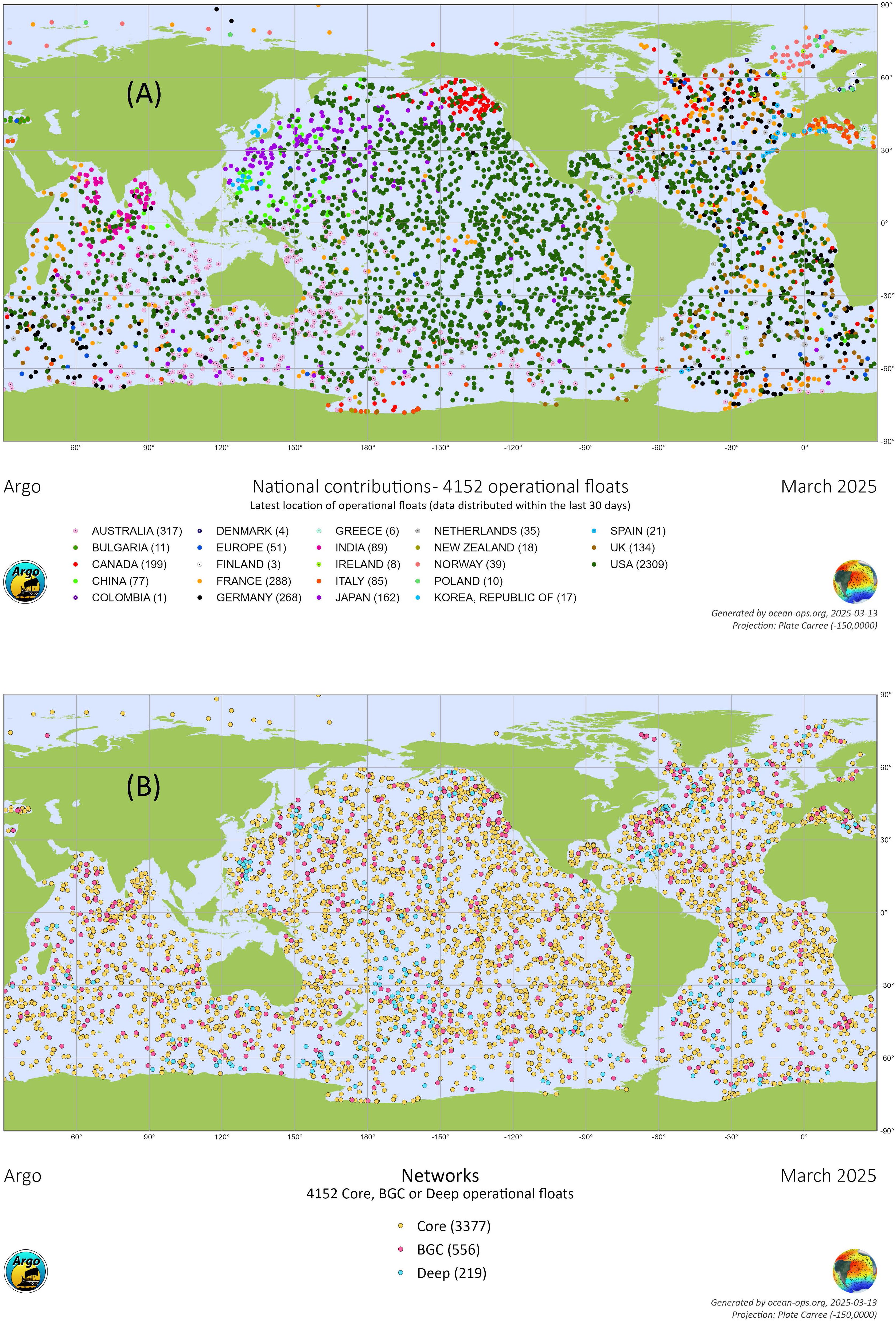
Figure 1. Status of the OneArgo network by contribution countries (A) or by float type (B). Among the 4,152 active floats, 556 floats (56% of the BGC Argo target) are equipped with two or more BGC sensors and 219 floats (18% of the Deep Argo target) are capable of sampling to 4,000 or 6,000 m. https://www.ocean-ops.org/share/Argo/Maps/networks.pdf.
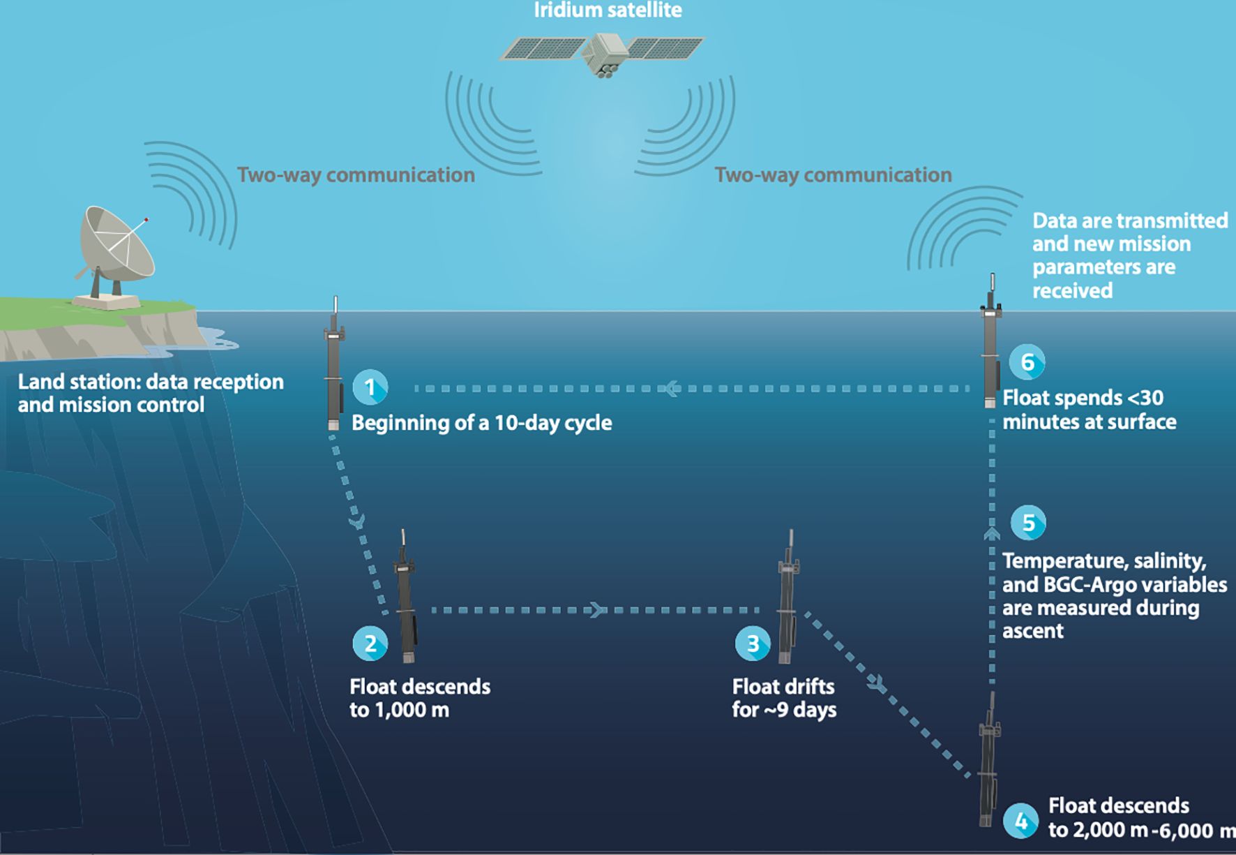
Figure 2. Schematic of a typical 10-day cycle of an Argo float. Updated from Claustre et al. (2020).
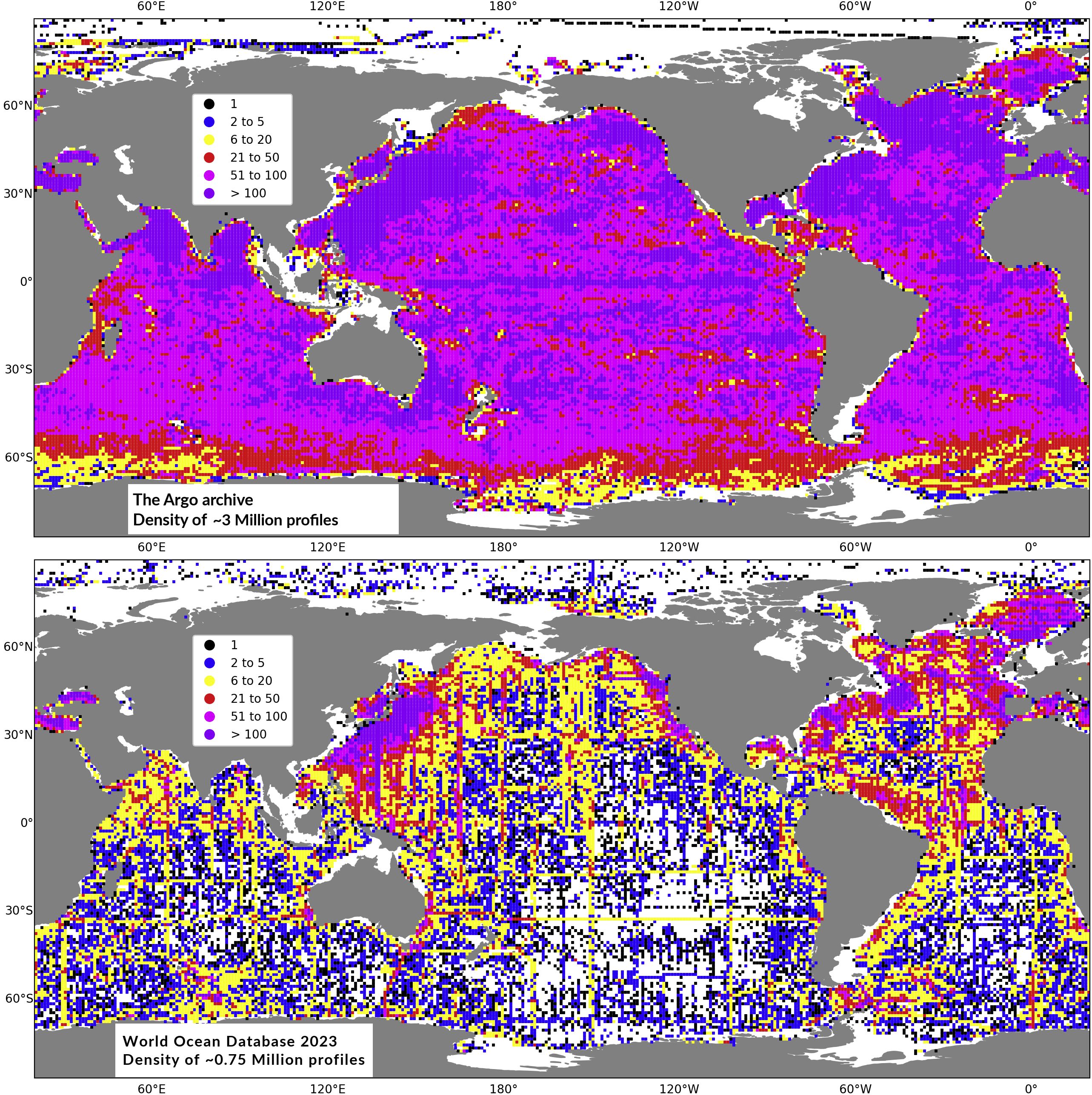
Figure 3. Spatial density per 1°x1° square of all about 3,062,060 Argo profiles (upper panel, 1999–2025) and all 751,197 non-Argo temperature-salinity-pressure profiles to depths greater than 1,000 m from the World Ocean Database 2023 (lower panel, all years through end of 2023). Updated from Roemmich et al., 2022.
Building on this legacy of success, OneArgo aims to radically expand and enhance Argo’s capabilities by 2030 (Roemmich et al., 2019). The targeted 4,700-float OneArgo will provide a more comprehensive and responsive global-ocean observing system. The Core Argo mission will cover the ocean interior (0-2,000 m) and marginal seas, with double density in western boundary currents and tropical regions, and stretch Argo coverage to ice-covered regions at high latitudes with the Polar Argo mission. The Deep Argo mission will extend profiling depth beyond 2,000 m to the ocean bottom (Zilberman et al., 2023a). The biogeochemical (BGC) Argo mission will integrate biogeochemical sensors in the upper 2,000-m (Claustre et al., 2020). Argo floats equipped with an ice-avoidance algorithm (based on Klatt et al., 2007) enable broadscale sampling in ice-covered seas. Deep Argo floats have increased pressure capability to profile to 4,000 m or 6,000 m depending on the float model, and increased CTD accuracy to resolve the deep-ocean signal (Thierry et al., 2025). BGC Argo floats are equipped with advanced sensors that measure a range of biogeochemical parameters (Bittig et al., 2019), including dissolved oxygen (for understanding ocean hypoxia, deoxygenation, and biological activity), pH (to track ocean acidification and assess the ocean carbonate system), nitrate (a key nutrient for phytoplankton growth), chlorophyll-a (a proxy for phytoplankton biomass and ocean productivity), suspended particles (for tracking particulate organic carbon and understanding biological carbon export) and downwelling irradiance (for measuring light penetration, which affects photosynthesis). Among the 4,700 profiling floats targeted in the OneArgo array, 1,000 will be equipped with BGC sensors and 1,200 will have deep-ocean measurement capabilities (> 2,000 m) (Roemmich et al., 2019).
OneArgo will expand global measurements from 3 to 14 Essential Ocean Variables (EOVs) defined by GOOS (Lindstrom et al., 2012) and volumetric coverage from ~45% of the ocean volume to more than 90% (Le Reste et al., 2016). The Argo program, and its extension OneArgo, are strongly grounded in the principles of the Framework for Ocean Observing. By building on this framework, OneArgo implicitly serves as a cornerstone of the broader GOOS system, particularly through its emphasis on clearly defined requirements, robust data management, and open, interoperable data access. As proof of its expected benefits, OneArgo contributes to two of the 17 Sustainable Development Goals (SDGs) adopted by all United Nations Member States in 2015: SDG 13 “Take urgent action to combat climate change and its impacts” and SDG 14 “Conserve and sustainably use the oceans, seas and marine resources for sustainable development”. It sits as well at the base of the value chain for many other SDG targeted during the UN Decade of Action, including Quality Education, Innovation and Infrastructure, Climate Action, and Life Below Water (Roemmich et al., 2022). Developing Argo and its extensions is one of the top priorities of the G7 Future of the Seas and Oceans Initiative (G7 FSOI, 2025).
Based on real-world large-scale pilots, the Argo Steering Team estimated in 2024 that the projected cost of OneArgo’s implementation, including float purchase and deployment, transmission costs, data management, and associated human resources, is approximately 100 million euros annually. Among the 4,152 presently-active floats of the Argo array (Figure 1B), 556 contribute to the BGC Argo mission (56% of the target) and 219 to the Deep Argo mission (18% of the target). Increased Core Argo float sampling in the marginal seas, western boundary current, tropical regions, and seasonally covered ice zones is emerging (Figure 3). The remaining gaps at high latitude highlight the need for enhancement of polar observations as part of OneArgo.
Over the past decade, the global Argo community has demonstrated, through research-based projects, the ability to build, deploy, operate and manage data for each of the new major missions in OneArgo (e.g., Bittig et al., 2019; Talley et al., 2019; Le Traon et al., 2020; Zilberman et al., 2023a). This capability has been developed in close collaboration with float and sensor manufacturers, who have played a central role in the success of the Argo program and the development of OneArgo through technological advances in the lifetime and capacity of the platforms (e.g., under-ice or bottom measurements, integration of new sensors), and in the improvement and development of sensors (e.g., Johnson, 2017; Bittig et al., 2018; Dever et al., 2022; Thierry et al., 2025). This capability was also based on a clear framework defined by the Argo community for integrating data from new sensors into the Argo data stream, and ensuring that the network provides its users with high-quality, unbiased and interoperable data of known accuracy (https://argo.ucsd.edu/expansion/framework-for-entering-argo/). This framework includes well-defined real-time and delayed-mode QC procedures based on peer-reviewed publications (e.g., Maurer et al., 2021 and Dall’Olmo et al., 2022), and a three-stage implementation phase: experimental deployments, global pilot deployment and global implementation. This capacity building internal to Argo has seen a shift of some resources from Core Argo to the new missions in some national programs. This has been compensated for in other national programs that have maintained core funding and found additional short term support for the new missions. Neither approach is sustainable in the long term. To realize the full OneArgo array, national programs have to be supported at three times the Core Argo cost, otherwise we will realize a badly degraded core array and only partially implement new mission arrays. At present, Argo operators are facing an opportunity window of around 5 years for the new funding to emerge before the array becomes sub-optimal across all missions. This underscores the urgency, from a logistical and community capacity view point (both on the government and commercial supplier sides), to secure the support to build on the existing momentum and drive toward global implementation of OneArgo. If full funding was rapidly ramped up over a period of 2–3 years in the near term, the community could deliver much of the OneArgo design by 2030.
In the face of rapid ocean and climate changes, and the need for environmental intelligence to manage and adapt to these, the urgency to expand Argo to OneArgo by 2030 is only increasing. This review paper highlights how Argo data form the backbone of many essential societal services, enabling applications that span climate monitoring (Section 2), ocean circulation monitoring and oceanic processes research (Section 3), ocean and weather forecasting (Section 4), ocean management (Section 6), and education (Section 7), aligning with the GOOS mission and framework. The present paper also addresses synergies between OneArgo and other major components of the global ocean observing system strengthening overall GOOS integration and impact (Section 5). This synthesis not only underscores the breadth of these services and their societal value but also describes the innovative capabilities that OneArgo can develop to meet emerging needs in both science and the ocean economy. In this sense, while drawing on the solid scientific foundations of Argo’s legacy and vision, the approach taken here is intentionally different from traditional review articles of this nature aimed at a technical audience. This paper is designed for a broader audience, including decision-makers and ocean managers, to illustrate how OneArgo is uniquely poised to address a wide range of societal needs in a time of urgency. By highlighting the diverse applications of OneArgo and its critical role in securing a sustainable future for humanity, this paper emphasizes the fundamental necessity of ensuring OneArgo’s full implementation and long-term sustainability.
2 Ocean and climate change
2.1 Heat content, Earth energy imbalance and hydrological cycle
Due to its high heat capacity, the ocean has absorbed about 90% of the excess heat received by the Earth System (von Schuckmann et al., 2023), as a result of increased atmospheric greenhouse gases (Loeb et al., 2021), delaying atmospheric warming but intensifying the Earth’s water cycle (IPCC, 2021). Argo, through its unprecedented spatial coverage, has revolutionized investigation of ocean heat content (e.g., von Schuckmann et al., 2023) and salinity changes (e.g., Durack et al., 2012) with reduced uncertainties (Desbruyères et al., 2016), central to understanding past climate and predicting future changes to Earth’s energy and water cycles.
Annual rate of change of the global integral of ocean heat content (Figure 4a) and multidecadal global-average temperature trends in the 0–2,000 dbar layer (Figures 4b, c) reveal an increase in ocean heat content throughout the water column, with warming of ~0.22 ± 0.07°C decade-1 near the surface diminishing to ~0.04 ± 0.02°C decade-1 by 400 dbar and then ~0.01 ± 0.002°C decade-1 at the 2,000-dbar maximum pressure of Core Argo (Figure 4c). This warming contributes to sea level rise through thermal expansion (e.g., Cazenave and Moreira, 2022; Sections 2.2 and 5.1); increases the frequency of extreme weather events like severe tropical cyclones, heavy precipitation, and agricultural and ecological droughts due to an intensifying global water cycle (IPCC, 2021); impacts ocean circulation (Section 3.1), oxygen levels in the ocean (Section 2.3) and more generally ecosystem functioning through more frequent marine heatwaves and increased ocean stratification (e.g., Li et al., 2020); and alters anthropogenic carbon uptake and storage (Bindoff et al., 2019; Sections 2.4 and 2.5).
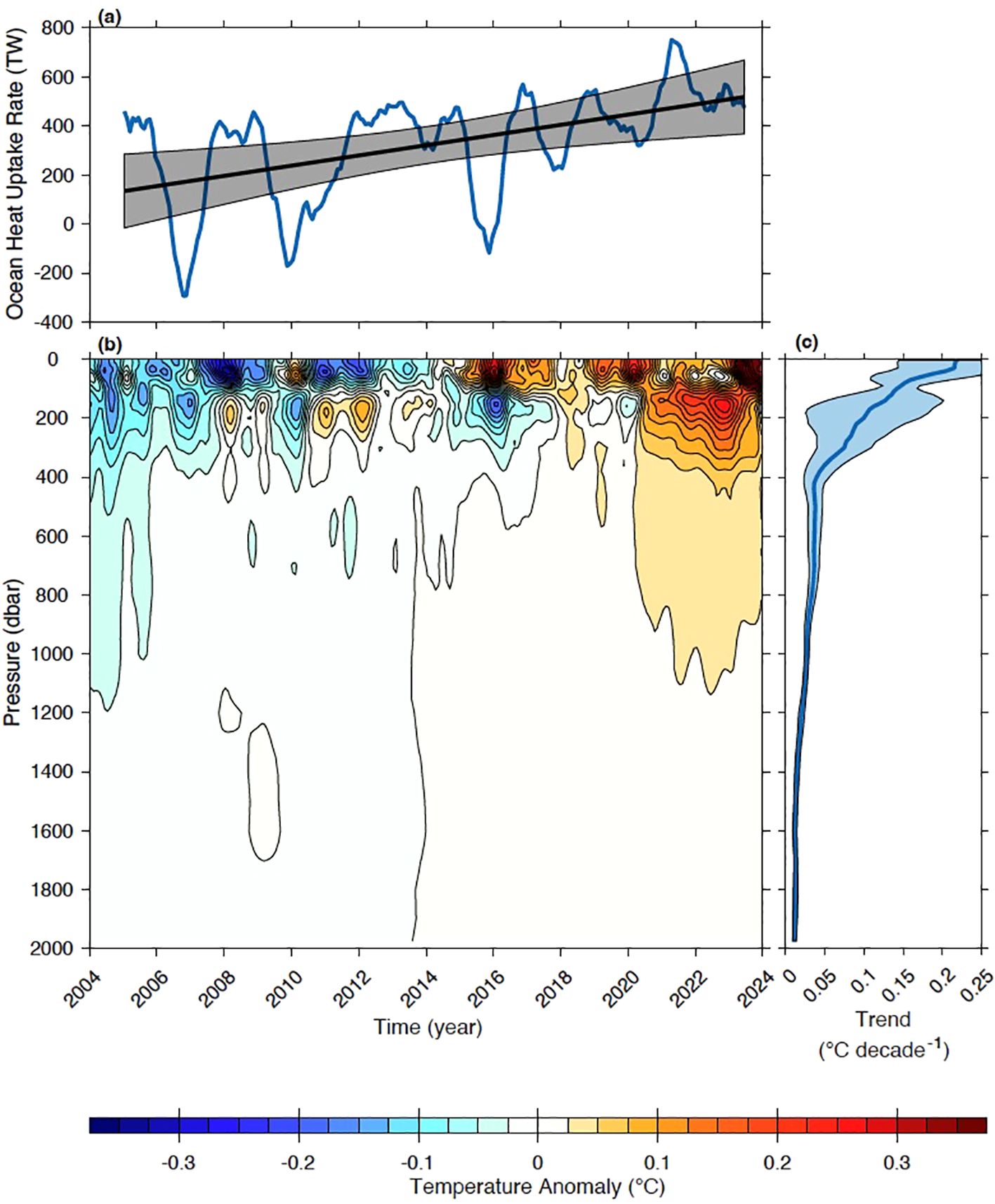
Figure 4. Analyses of ocean temperature and heat content maps using Argo data as training data in a machine learning algorithm (Lyman and Johnson, 2023). (a) 0–2,000 dbar ocean heat uptake rates (blue line) in TW calculated as one-year differences of one-year averages (e.g., the first value at 2006 is the difference of ocean heat content for calendar year 2006 minus that for calendar year 2005). A linear fit to the time-series (black line) with 5–95% confidence intervals (gray shading) highlights the acceleration of ocean heat uptake rates. (b) Global temperature anomalies in °C vs. time and pressure with a seasonal cycle and record-length mean removed, then low-pass filtered with a 5-month (3-month half-width) Hanning window. (c) Ocean warming trends in °C decade-1 (blue lines) with 5–95% confidence intervals (blue shading) calculated over the 20-year record length from the de-seasoned data prior to smoothing.
Global temperature anomalies over the past 20 years (Figure 4b) reveal a recurring interannual pattern of vertical heat distribution. During El Niño, warm anomalies appear at the surface while cooler anomalies are concentrated around 160 dbar, whereas the opposite occurs during La Niña (e.g., Roemmich and Gilson, 2011). This variability is overlaid on a broader multi-decadal warming trend. Deeper than 400 dbar, the warming trend dominates. Due to the ocean’s huge thermal inertia, the annual rate of change of the global integral of ocean heat content (Figure 4a, blue line) reflects 90% of Earth’s Energy Imbalance (EEI; e.g., von Schuckmann et al., 2023). The trend over the Argo record (black line) shows a doubling of the EEI, in remarkable agreement with nearly independent top-of-the-atmosphere satellite estimates (e.g., Loeb et al., 2021; Minière et al., 2023). The interannual variability in the EEI is associated with El Niño, with ocean heating rates dipping during surface warm phases and peaking during surface cold phases (Figure 4a).
Historical shipboard and Deep Argo data show that ocean warming intensifies again towards the bottom (not shown). Warming deeper than 2,000 m in recent decades accounts for about 10% of ocean heat uptake (e.g., Johnson and Purkey, 2024). This bottom-intensified warming is a signature of a reduction in the Antarctic Bottom Water formation rate, predicted by models to continue diminishing in coming decades (e.g., Li et al., 2023). A major motivation for the global implementation of Deep Argo is to monitor these momentous changes globally in real time as Core Argo is doing for the upper 2,000 m (vastly augmenting data collection beyond sparse revisits by ships at decadal intervals; Section 5.4), and to provide a deep-ocean constraint for global climate models still plagued with unphysical deep-ocean drifts which reduce their utility for future prediction (e.g., Durack et al., 2018).
A warming lower atmosphere, consistent with a warming surface ocean (Figure 4), stores and transports more water vapor (IPCC, 2021) across Earth’s surface. The ocean salinity field is changing in response, increasing inter-basin salinity contrasts and strengthening regional salinity extrema both at the surface and at depth (e.g., Curry et al., 2003; Boyer et al., 2005; Hosoda et al., 2009; Durack et al., 2012; Cheng et al., 2020). The ocean acts as an integrator over time and space scales, accumulating freshwater changes across noisy precipitation and evaporative events. The changes are expressed with enhanced positive salinity anomalies in regions dominated by an evaporative regime and negative salinity anomalies or freshening in regions dominated by precipitation-dominant regimes (Figure 5). These changes align with a 7% intensification of the global water cycle, consistent with the theoretical Clausius-Clapeyron relationship for ~1°C of surface warming. High-quality salinity data from Argo combined with sparser historical data have enabled the detection of an intensification of ocean salinity change patterns, one of the first clear lines of evidence of an intensifying hydrological cycle (Pierce et al., 2012; Bindoff et al., 2013). These salinity changes have been used to compare theoretical predictions and numerical climate results (e.g., Durack et al., 2012; Cheng et al., 2020; Eyring et al., 2021).
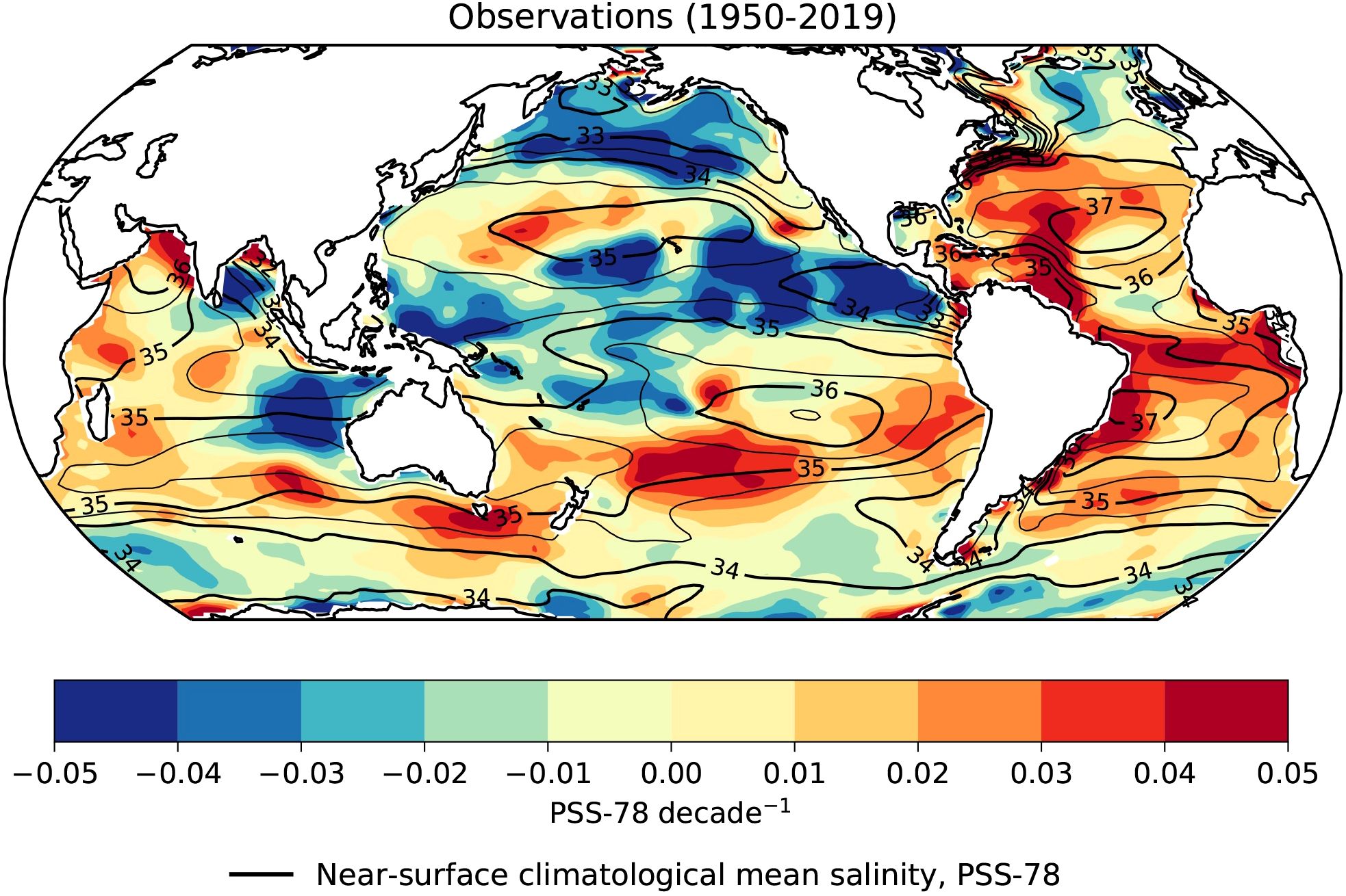
Figure 5. Map of observed near-surface ocean salinity linear trends over the period 1950–2019 (after Durack et al., 2010, updated). The analysis leverages all salinity profile data available from ship-based CTD casts and, in the more recent period, from the Argo array. Regions of blue show freshening, primarily located in precipitation-dominant regions, such as the Pacific Inter-Tropical Convergence Zone, the Maritime Continent, and subpolar regions in both hemispheres. Regions of red show enhanced salinification, which is co-located with evaporation-dominant regimes such as the subtropical gyres whose distribution is similar to that of climatological salinity maxima zones. Reproduced from Eyring et al. (2021) with permission.
OneArgo’s ability to support tracking Earth’s warming rate accurately and the associated hydrological cycle intensification in real time is an essential tool for monitoring the efficacy of future climate mitigation, supporting adaptation management and climate resilient pathways, and otherwise informing policy decisions.
2.2 Sea level rise
Global mean sea level rise, one of the most prominent indicators of climate change, is driven by changes in ocean volume due to ocean warming and salinity changes (known as steric sea level), and by increases in global ocean mass (known as barystatic sea level; Gregory et al., 2019) due to the influx of freshwater from ice sheet mass loss (Greenland and Antarctica) and mountain glacier melting. Understanding and predicting global mean sea level rise is of vital importance to many nations (e.g., Hinkel et al., 2018) facing the risk of coastal flooding and erosion. Sea levels are projected to rise 30–60 cm by 2100 if we sharply reduce our greenhouse gas emissions, or 60–100 cm under a very-high-emissions scenario. In 2020, 267 million people (3.4% of the world’s population) lived within 2 m above sea level. It is anticipated that 410 million people will be impacted by a 1-meter sea level rise and zero population growth (Hooijer and Vernimmen, 2021). Without adaptation, flood damage for sea level rise between 0.3 to 1.3 m, depending on the socio-economic and climate scenarios, is estimated to cost between 10 and 50 trillion USD per year (OECD, 2019).
Argo has revolutionized our understanding of global mean sea level rise and regional sea level trends historically observed by satellite altimetry (Section 5.1). Argo temperature profiles were instrumental for assessing that the contribution of global ocean warming to global mean sea level rise accounted for 35% of the net linear trend of 4.1 mm/yr over the period 2005–2022 (Figure 6). This latter estimate appears to be greater than the linear trend of 3.2 ± 0.4 mm/yr computed over 1993–2023, denoting an acceleration of this global mean rise. In addition, Argo salinity data have provided strong constraints on the geophysical corrections needed for the space gravity missions (i.e., GRACE and GRACE-FO) that have remotely monitored the barystatic component of sea level due to freshwater exchange with the continent (Llovel et al., 2019), which corresponds to a ~10 cm increase over the period 1993–2022. Argo floats have also revealed warm water inflow near ice shelves, driving basal melt, reducing buttressing and increasing Antarctica’s contribution to sea level (Hirano et al., 2023; van Wijk et al., 2022a).
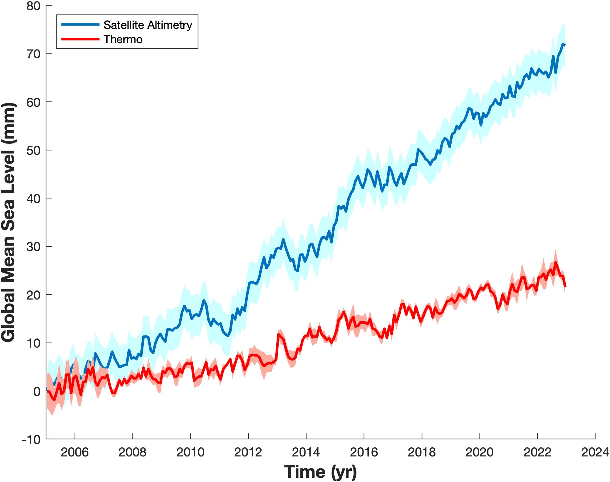
Figure 6. Global mean sea level observed by satellite altimetry representing the sum of barystatic and thermosteric components (blue curve; C3S data, Legeais et al., 2021), and global mean thermosteric sea level inferred from Argo floats (red curve). Envelops represent the uncertainty at 1 standard deviation (updated from Llovel et al., 2023).
Sea level is not rising uniformly and is subject to large regional variability. Steric sea level trends inferred from Argo data over 2005–2015 show spatial patterns coherent with altimetry-based sea level trend patterns over the same period (Figures 7A, B), revealing that the latter are driven by density changes induced by temperature and salinity. Steric sea level trends driven by temperature variations only (known as thermosteric sea level, Figure 7C) display patterns similar to overall steric sea level trends, suggesting that temperature plays a significant role in these changes. However, salinity’s contributions (known as halosteric sea level, Figure 7D) show large trends in the North Atlantic and Indian Oceans, suggesting that salinity can enhance or compensate for the contribution of temperature. These findings highlight the importance of continued monitoring of regional density changes (needing simultaneous temperature and salinity observations), as they can regionally amplify or offset long-term global sea level rise. Monitoring and understanding regional sea levels is also crucial for assessing the realism of climate models used by policymakers to anticipate and mitigate sea level rise impacts. OneArgo’s ability to better document the contribution of the deep ocean (> 2,000 m) and ice-covered regions to steric sea level rise will also be a major step forward in reducing uncertainties in steric sea level estimates from in-situ observations.
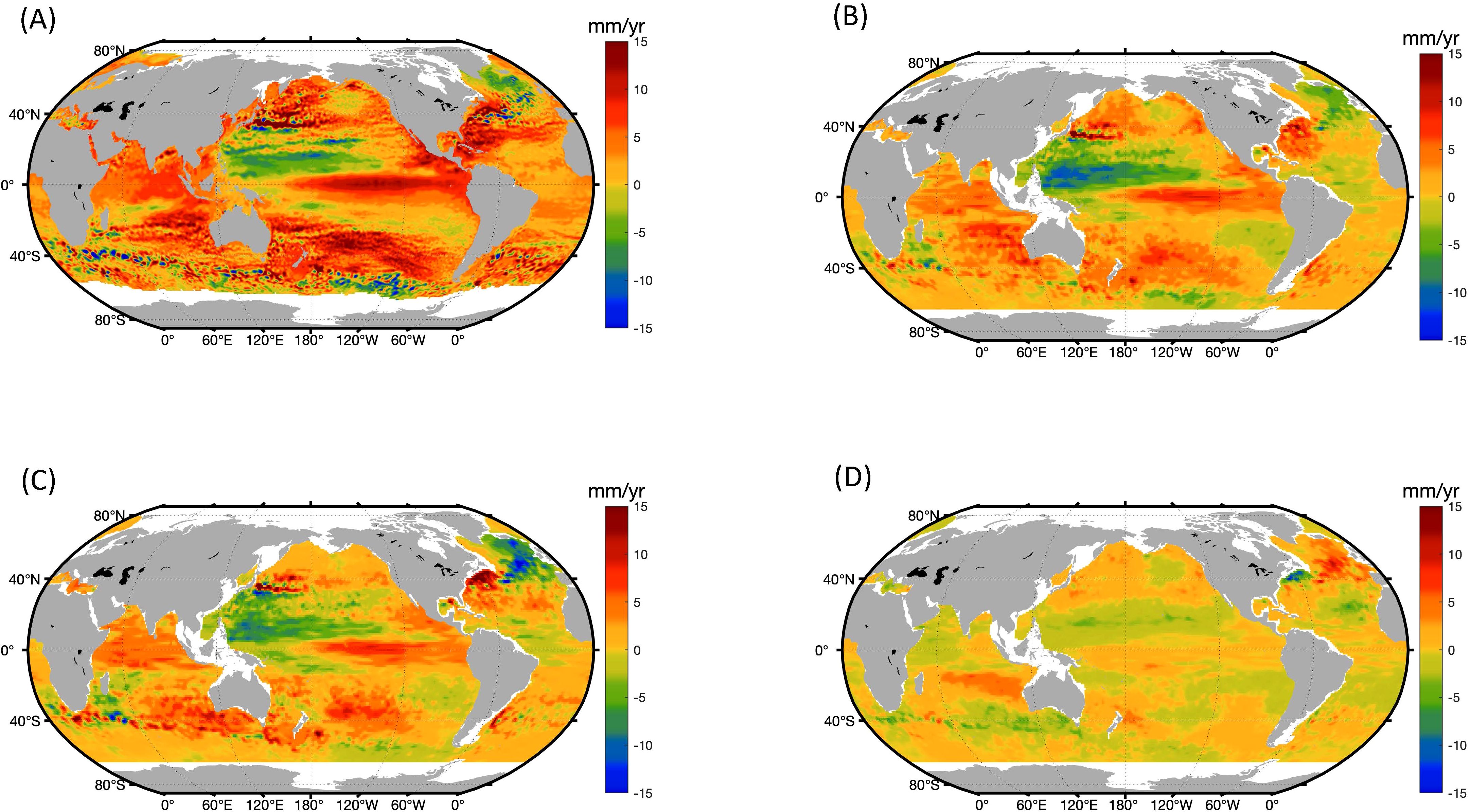
Figure 7. (A) Regional sea level trends observed by satellite altimetry over 2005-2015. (B) Regional steric sea level trends computed over 2005–2015 from Argo data (Roemmich and Gilson, 2009) for the 0-2,000 m depth. (updated from Llovel and Lee, 2015). (C) Same as (B) but for the temperature-driven steric component (thermosteric component). (D) Same as (B) but for the salinity-driven steric component (halosteric component).
2.3 Deoxygenation and denitrification
While oxygen in the ocean is important for the survival of the plants and animals that live there, its concentration in the ocean interior has been decreasing (Stramma et al., 2008; Keeling et al., 2010; Breitburg et al., 2018). Human activities are the primary cause of ocean deoxygenation in both coastal environments and the open ocean (IPCC, 2021). Globally, the ocean has lost about 2% of its oxygen content since the 1960s (Schmidtko et al., 2017), and this is projected to decline further (Bindoff et al., 2019). Such loss in the open-ocean interior may have important effects on marine life, ocean productivity, ecosystem structure, and the biogeochemical cycle of nitrogen, impacting the health of marine ecosystems, a sustainable ocean economy, and communities dependent on the ocean (e.g., tourism, fisheries, aquaculture, ecosystem services, and marine protected areas). Even very small declines of oxygen can affect biodiversity, especially in locations that may be close to physiological thresholds, such as oxygen deficient zones (ODZ). Expansion of ODZs, where nitrate is converted to nitrogen (N2) by bacterial metabolism (denitrification), is particularly concerning as this has the potential to reduce ocean stocks of nitrate, an essential plankton nutrient.
Deoxygenation is controlled by three interacting processes: increasing ocean temperatures (Section 2.1), changing ocean circulation and ventilation of the ocean interior (Section 3.1), and changing export of organic carbon into mid-waters of the ocean (Resplandy et al., 2018). Increasing upper ocean temperatures lead to a decrease in surface oxygen concentrations due to reduced oxygen solubility and the accompanying increase in thermal stratification of the ocean, which limits mixing of oxygen-rich surface waters into the interior. However, the future trajectories of ocean ventilation and organic carbon export are less clear (e.g., Fu et al., 2018). Recent work indicates that the extent of denitrification in the ODZ of the Eastern Tropical North Pacific can oscillate on decadal time scales, suggesting a system that is easily influenced by environmental change (Duprey et al., 2024). Understanding the future trajectory of ocean oxygen and the processes that control it will require an observing system that links ocean physics, upper ocean carbon cycling, and in situ oxygen measurements throughout the open ocean (Grégoire et al., 2021).
Despite the need to observe oxygen and the processes that control it, the shipboard observations that have formed the basis for understanding its distribution are decreasing (Figure 8). Fortunately, Argo floats now return 20 times more oxygen profiles per year than ships in the upper 2,000 m. The growing usage of DO sensors on Deep Argo floats is a new contributor to filling major observational gaps below 2,000 m (Zilberman et al., 2023a). OneArgo is revolutionizing our ability to observe spatial and temporal variability in ocean oxygen (e.g., Sharp et al., 2023; Kolodziejczyk et al., 2024). When coupled with nitrate, pH, and bio-optical sensors (e.g. chlorophyll-a (Chla) and particle backscattering (bbp)) on BGC Argo floats, our ability to observe the influence of carbon export on oxygen (e.g., Su et al., 2022) and the influence of ODZs on the nitrogen cycle (Johnson et al., 2019) will transform our ability to observe and predict the trajectory and influence of ocean deoxygenation.
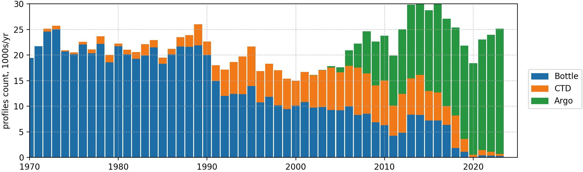
Figure 8. Oxygen profiles per year in the NOAA World Ocean Database that have been collected from bottle casts and typically analyzed by Winkler titration, and oxygen sensor data from shipboard CTD casts, and by Argo profiling floats. Updated from Ito et al. (2024).
2.4 Acidification
The ocean provides an important service by absorbing 25–30% of annual anthropogenic CO2 emissions (Friedlingstein et al., 2024). However, this absorption has profound consequences as dissolved CO2 reacts with seawater to form carbonic acid, leading to ocean acidification. The resulting decline in surface ocean pH, currently occurring at a rate of approximately -0.002 per year, has serious implications for marine ecosystems, particularly for organisms that rely on calcium carbonate structures, such as pteropods, corals, and shellfish (Bednaršek et al., 2019; Doney et al., 2020).
While long-term ocean acidification trends have been identified through sustained pH measurements at ocean time-series stations (Dore et al., 2009), these records are geographically sparse (e.g., Bates et al., 2014). The much denser set of surface ocean pCO2 observations have been used to create detailed maps of acidification rates at the global scale (Iida et al., 2021; Ma et al., 2023). However, these observations do not extend into subsurface waters or sample the huge Southern Hemisphere oceans regularly. Subsurface pH measurements at the global scale have been primarily limited to the decadal repeat hydrography program now conducted by GO-SHIP (Section 5.4). These observations have been essential to identify where decreasing pH and the associated change in CaCO3 mineral saturation may drive critical ecological tipping points in the coming decades (McNeil and Matear, 2008; Bednaršek et al., 2019). They have also helped clarify that the largest impacts of ocean acidification for many carbonate system parameters, including pH, are occurring well below the ocean surface (Arroyo et al., 2022; Fassbender et al., 2023). Increasing the spatial and temporal coverage of these interior ocean measurements is vital to better understand both processes and impacts.
BGC Argo profiling floats equipped with pH sensors are now generating data records that can be combined with shipboard measurements to map acidification rates throughout the ocean (Section 5.4). For example, by using float and ship measurements to map pH throughout the Southern Ocean, Mazloff et al. (2023) found that the zonal mean pattern of acidification rates throughout the upper 1,500 m of the Southern Ocean was strongly influenced by the large-scale overturning circulation. Lower rates of acidification occur in regions of strongest upwelling of deep waters that have had less exposure to atmospheric CO2. Expanding BGC Argo coverage and sustaining long-term observations will be essential for tracking how acidification propagates through the ocean interior. These insights will improve climate projections, refine marine ecosystem impact assessments, and support policymakers in developing strategies to mitigate and adapt to ocean acidification.
2.5 Towards ecosystem monitoring
Marine ecosystems, spanning from microscopic phytoplankton to higher trophic levels such as fish, are fundamental to oceanic biodiversity and the overall health of the planet. These ecosystems are increasingly affected by physical (see Sections 2.1 and 3.1), chemical (Sections 2.3 and 2.4), and biological changes, driven by climate variability and human activities. Historically, studying these impacts for the open ocean has been challenging due to observational limitations. The nascent OneArgo fleet, in combination with the other components of the ocean observing system (e.g. ocean color satellites; Section 5.3), now provides scientists with a comprehensive suite of ecosystem observations enabling new understanding of ocean ecosystems, their evolution, and feedbacks related to climate change. This is vital for scientific and societal needs, such as fisheries management (Section 6.1), carbon sequestration measurement (Section 3.4), and assessing the impact of human interventions (Section 6.2). The OneArgo fleet thus offers significant advancement in the characterization of the various components of marine ecosystems and their impact on the biogeochemical processes essential for sustaining life on Earth.
The composition of phytoplankton forms the foundation of marine ecosystems. BGC Argo optical measurements, such as chlorophyll-a (Chla) and particle backscattering (bbp), provide valuable insights into phytoplankton biomass and growth (e.g., Arteaga et al., 2022), as well as composition at the base of oceanic food webs (Cetinić et al., 2015; Terrats et al., 2020; Stoer and Fennel, 2024). Recently, the ability to characterize phytoplankton composition has expanded with the launch of the near-synoptic PACE (Plankton, Aerosol, Cloud, ocean Ecosystem) satellite mission based on an ocean-color satellite with a hyperspectral sensor capturing light across continuous visible wavelengths for detailed climate and ecosystem studies, coupled with the first operational deployments of floats also equipped with hyperspectral sensors (Jemai et al., 2021) (Section 5.3). These advancements represent a potential breakthrough, as they support the development of BGC Argo-based 3D products for phytoplankton and Chla. These new products will build upon the useful data (Chla, bbp) already provided by the Copernicus Marine Service (Sauzède et al., 2016; Figure 9).
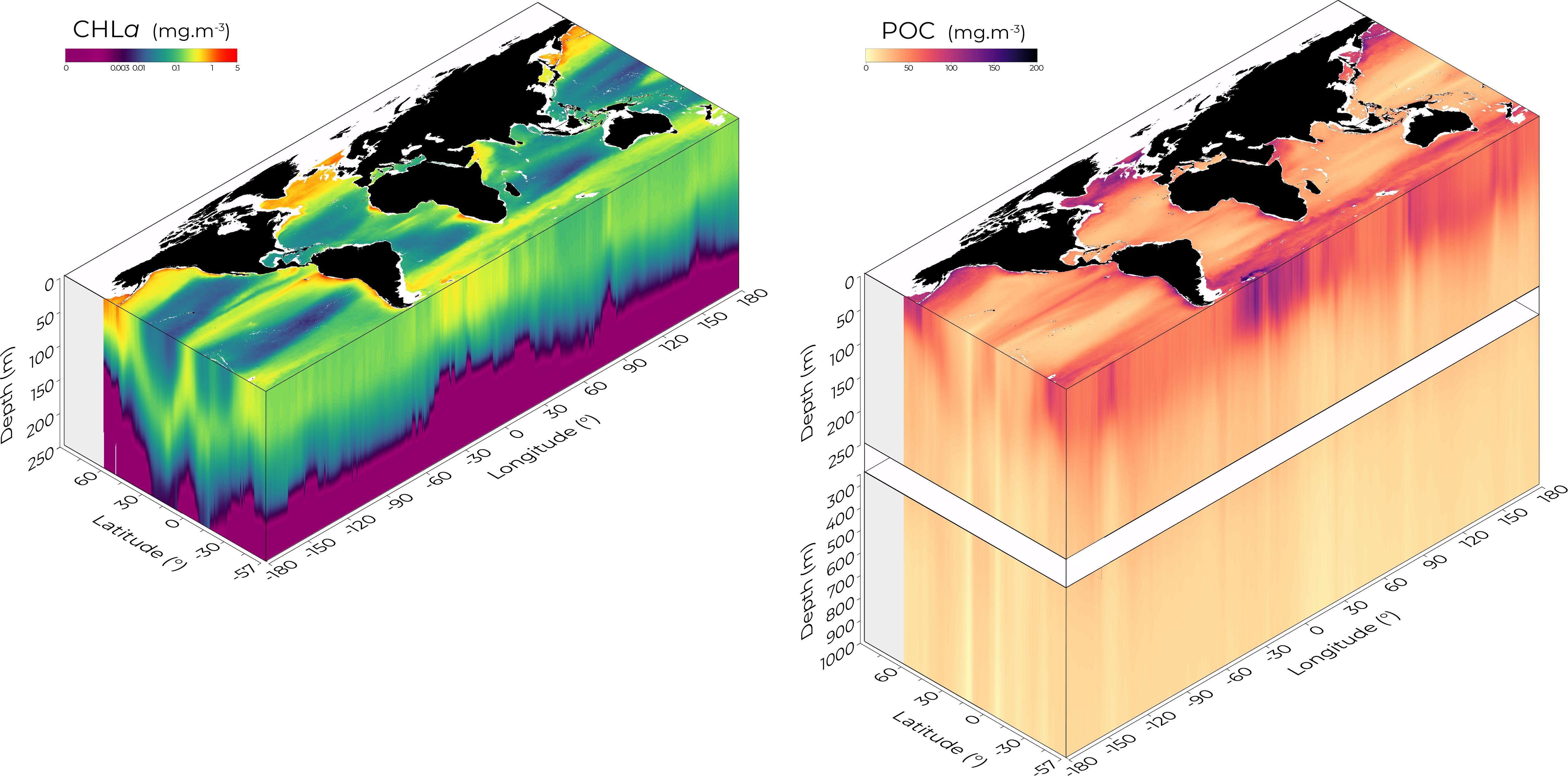
Figure 9. Three-dimensional climatology of Chlorophyll-a concentration (Chla; right panel) and Particulate Organic Carbon (POC; left panel), averaged over all months from a 25-year time series. POC is derived from the particulate backscattering coefficient (bbp) and retrieved down to 1,000 m depth, as shown in the right panel where it extends deeper than Chl, which is retrieved within the productive layer. This visualization results from estimates produced by the neural network developed by Sauzède et al. (2016), which combines remote-sensing satellite data with Argo-based hydrological profiles to retrieve depth-resolved bio-optical vertical profiles. The neural network is trained using BGC Argo data as a reference, based on ~60,000 Biogeochemical-Argo vertical profiles available for this version. This climatology is derived from a product that is operationally released by the European Copernicus Marine Service and updated annually (Sauzède et al., 2024). Its resolution and accuracy continue to improve, thanks to the increasing availability of BGC Argo data.
Zooplankton data acquisition with Argo floats (not yet an official OneArgo parameter endorsed by IOC/UNESCO) is in an initial experimental phase, yet advancements in technology hint at a promising future. While there has been progress in studying the photosynthetic base of the ocean food web, understanding the flow of carbon to zooplankton remains challenging. The Underwater Vision Profiler (UVP6), incorporating AI-driven zooplankton recognition (Picheral et al., 2022), shows potential, especially in high-latitude regions where it reveals critical zooplankton migration and possible carbon transport to deeper waters (Section 3.4). Additionally, experimental miniature echosounders on floats could help quantify macroplankton, positioning OneArgo for global meso- and macro-plankton monitoring.
Finally, although OneArgo cannot directly access higher predators (fishes), it enables the realization of four-dimensional global or regional maps of environmental drivers (e.g., temperature, pH, light, O2, Chla) essential for characterizing the ecological niches of important species (e.g., Roemmich and Gilson, 2009; Sharp et al., 2023). Monitoring changes in the volumes of these niches over the long term (e.g., expanding Oxygen Deficient Zones) or as a result of extreme events will become essential and offers the potential to better support protection and management of these resources (Section 6.1), such as Marine Protected Areas.
2.6 Climate modeling and climate projection
Climate projections are simulations of Earth’s climate for future decades (typically until 2100) based on assumed “scenarios” for the concentrations of greenhouse gases, aerosols, and other atmospheric constituents that affect the planet’s radiative balance. Climate projections rely on the use of comprehensive climate and Earth System models (Eyring et al., 2016) that have been evaluated against observations by modelers and analysts long before the Argo program was conceived (Durack et al., 2025). However, the availability of Argo data has had an impact on the reliability of climate projections by enabling improved initialization of climate models, better representation of climate processes in models, reduction of large-scale biases, assessment of recent climate changes and climate variability in models, and enabling future climate projections to be constrained.
Climate models need to be initialized either with a mean state of the ocean temperature and salinity field which is run to quasi-equilibrium (typically for multi-century projections) or via data assimilation to produce an initialized state (typically for multi-annual–decadal predictions). Argo data have been particularly valuable for the latter application (e.g., Decadal Climate Prediction Project; Boer et al., 2016), and in a similar way, for operational ocean forecasting and seasonal forecasting (e.g. Balmaseda et al., 2015; Shi et al., 2017; see Section 4).
Argo has played an important role in the development of ocean model parameterizations to reduce biases, as new measurements have provided insights into observed ocean processes and operation (e.g., Griffies et al., 2015). This has included tuning of the ocean mixed layer schemes and vertical diffusivity (e.g., Acreman and Jeffery, 2007; Zhu et al., 2018; Sane et al., 2023). Model biases are generally large, even compared to the Northern Hemisphere dominant CTD and XBT data from the pre-Argo period (e.g., Gordon et al., 2000). However, the pre-Argo lack of Southern Ocean data has now been addressed by Argo and has enabled model deficiencies to be identified there (e.g., Hyder et al., 2018).
The ability of climate models to simulate observed change is typically assessed over a historical period (roughly 1850 to the present; see for example IPCC AR6 WGI Chapter 3; Eyring et al., 2021). Such assessment involves many of the quantities discussed in previous sections – ocean heat content, salinity, water mass changes. In particular, the improved temporal and spatial resolution of available data from Argo and the understanding this enables has improved our ability to evaluate the representation of ocean heat uptake and ocean salinity in climate models (e.g., Lyman et al., 2014; Durack et al., 2010; Hosoda et al., 2009; Helm et al., 2010). There has also been a productive synergy between climate models and observations. Gregory et al. (2004) identified issues with the ocean heat content timeseries during the XBT period which was quantified by Gouretski et al. (2007). Corrections to the XBT measurements (e.g., Wijffels et al., 2008) then enabled evaluation of decadal variability in the ocean in climate models (Domingues et al., 2008). Looking to the future, the ocean heat content time-series provided by Argo has the potential to constrain future projections of climate (Lyu et al., 2021).
As large-scale biases in climate models are reduced, Argo will become increasingly valuable for evaluating both variability and long-term trends. The OneArgo vision to sample the deep ocean and the biogeochemical fields will be especially important as we advance full Earth System models representing the carbon cycle with observed fields (Turner et al., 2023). OneArgo will contribute to the improvement of global ocean biogeochemistry models. To date, these models have had limited validation data, particularly to constrain variability on seasonal to multi-annual scales (Fu et al., 2022; Séférian et al., 2020). Accurate representation of marine biological and physical processes, and their interactions, will be required to produce accurate reconstructions and projections of the ocean carbon sink (e.g., Rodgers et al., 2023; Terhaar et al., 2024).
From a climate modelling perspective, there is an anticipated need to augment Argo sampling to capture mesoscale processes and under-ice shelf cavities. Climate models are moving towards increasing temporal and spatial resolutions (e.g., Griffies et al., 2015) and there is a need for supplemental observations to validate model predictions at smaller scales. In particular, monitoring the temperature of water flow into ice shelves cavities and melt rate magnitude is critical for predicting the evolution of the Antarctic ice sheet (Fox-Kemper et al., 2021). Polar Argo floats are a cost-effective tool to monitor exchange with ice shelf cavities (e.g. Girton et al., 2019; Falco et al., 2024; Sallée et al., 2024).
3 Investigating leading physical and biogeochemical oceanic processes
3.1 Ocean circulation and meridional overturning cell
Argo data are now an ubiquitous tool for fundamental research of the oceanic large-scale circulation and its role in transporting physical or biogeochemical properties. Advances include mapping of the time-mean circulation at the 1,000-meter nominal parking depth using Argo float displacement during their park phase (e.g. Ollitrault and Rannou, 2013; Colin de Verdière et al., 2019; Zilberman et al., 2023b), reconstructions of basin-scale horizontal balanced flows (Wijffels et al., 2024) and associated property transport (Desbruyères et al., 2019; Mercier et al., 2024; Zilberman et al., 2020; Asselot et al., 2024; Chandler et al., 2024), and the discovery of abyssal water pathways (Racapé et al., 2019). Argo data have proven particularly useful for improving our understanding of the Meridional Overturning Circulation (MOC). This integrated view of large-scale ocean circulation, which distributes heat, freshwater, and biogeochemical properties (e.g. carbon, oxygen) around the globe (Ganachaud and Wunsch, 2002, 2003), establishes the mean climate state and its variability on interannual to longer time scales (Buckley and Marshall, 2016; Jackson et al., 2015), regulates the exchange of CO2 with the atmosphere (Sigman et al., 2010), and influences marine ecosystems (Schmittner, 2005). The MOC exerts a strong influence over regional ocean and air temperatures, rainfall, the frequency of hurricanes and storms, or even the global carbon cycle (Lozier et al., 2017). In the Atlantic, the MOC (AMOC) transports warm water north in the upper layer and cold water south at depth. The warm-to-cold conversion and sinking of water in the North Atlantic are associated with intense exchanges of heat, oxygen, carbon and other nutrients, which are vital for the viability of ocean ecosystems and play an instrumental role in ocean heat storage and carbon sink (Pérez et al., 2013). The Southern Ocean overturning circulation completes the global-scale MOC by converting cold water of North Atlantic origin to warmer deep and intermediate waters that return to the Atlantic to close the global circulation (Marshall and Speer, 2012). The vigorous overturning in the Southern Ocean accounts for 70% of global ocean storage of anthropogenic heat (Frölicher et al., 2015; Armour et al., 2016) and 40% of anthropogenic carbon uptake (Khatiwala et al., 2009) and returns nutrients to the surface ocean to support marine productivity (Sarmiento et al., 2004). Argo data in the Southern Ocean have been critical to quantify global ocean heat storage (von Schuckmann et al., 2023), to identify the key processes that link the upper and lower limbs of the MOC (Sallée et al., 2012), and to track changes in the water masses that contribute to the MOC (Gao et al., 2018; Meijers et al., 2019; Portela et al., 2020), including rapid warming and contraction of deep waters (Foppert et al., 2021).
The MOC in the Atlantic and Southern Ocean is expected to weaken during the 21st century (IPCC, 2021), and could even collapse (Ditlevsen and Ditlevsen, 2023; van Westen et al., 2024; Li et al., 2023) in response to increased freshwater input from melting ice sheets and changes in ocean temperature and salinity due to global warming, leading to substantial climate change. Understanding the response of the MOC to future climate changes is of critical societal importance given the influence of ocean circulation on regional and global climate (Lozier et al., 2017). Such understanding relies heavily on observations of the ocean’s velocity and property fields because climate models vary widely in their simulation and prediction of MOC variability (IPCC, 2023). As such, over the past two decades, the international community has implemented several trans-basin observing systems for estimating MOC variability (Volkov et al., 2024). Central to these observing systems are boundary current mooring arrays measuring velocity and property fields. In the Atlantic for example, OSNAP (Overturning in the Subpolar North Atlantic Program; Figure 10 and Lozier et al., 2017) has a number of boundary arrays from the Labrador coast to the Scottish shelf. However, boundary arrays alone are insufficient to estimate trans-basin fluxes of volume, heat and freshwater, and the continuous measurement of the vast ocean interior with these fixed arrays is prohibitively expensive. Instead, these observing systems rely on temperature and salinity data from Argo (Section 5.7), combined with climatological property data, to calculate monthly trans-Atlantic heat and freshwater fluxes.
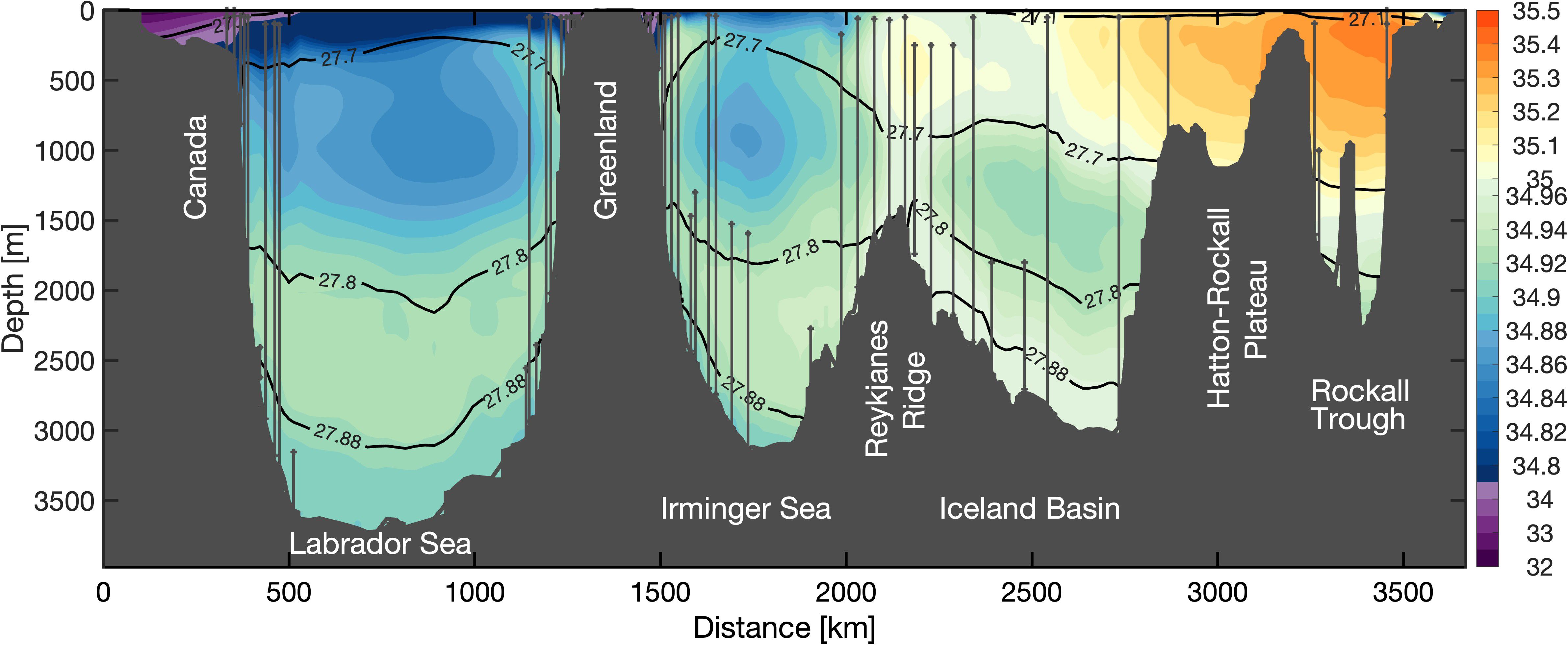
Figure 10. The 6-year mean salinity section (colored shading) with moorings marked by the vertical black lines. The horizontal black lines represent the isopycnals of 27.10, 27.70, 27.80, and 27.88 kg m−3. The interior salinity field (and likewise for temperature) is largely based on Argo data and allows the estimation of cross-section fluxes of mass, heat and freshwater in between the mooring lines. From Fu et al. (2024).
Critically, Argo data have enabled us to estimate ocean heat storage between AMOC observing arrays in the North Atlantic (Li et al., 2021). The combination of trans-basin lines with Argo float data has produced new estimates for the time-mean surface heat and freshwater divergences over a wide domain of the Arctic-North Atlantic region. Furthermore, these data collectively allow us to calculate the total heat and freshwater exchanges across the surface area of the extratropical North Atlantic between the OSNAP and RAPID-MOCHA (RAPID Meridional Overturning Circulation and Heat-flux Array) arrays. With longer time series from OSNAP, time-varying estimates will soon be possible.
While Argo data are indispensable to the AMOC metrics, these calculations still rely on relatively sparse sampling below 2,000 m in the ocean interior, mainly provided by GO-SHIP cruises (Section 5.4). Even if the property fields below this depth are less variable than those above it, having time-varying estimates of the temperature and salinity below 2,000 m would reduce our uncertainty of AMOC variability, particularly in the subpolar North Atlantic where overflow waters from the Nordic Seas are found below this depth. Because the properties of the overflow waters are expected to drastically change in the years and decades to come, an increase in the number of Deep Argo floats in this area is critically needed.
3.2 Mesoscale eddies
Motions at the oceanic mesoscale, one of the most dominant sources of variability in the ocean, typically occur at horizontal scales of tens to hundreds of kilometers and time scales of weeks to months. Accounting for nearly 90% of the global ocean kinetic energy (Ferrari and Wunsch, 2009), mesoscale variability plays a central role in the dynamics of the ocean and significantly impacts the distribution of heat, fresh water, carbon, oxygen, and other water properties, thereby influencing global climate and marine ecosystems. Motions at these scales are frequently equated with long-lived vortices, called mesoscale eddies, that can be identified via satellite observations of sea level (Chelton et al., 2011). Although not originally designed to capture motions at these scales, the Argo array has nonetheless revolutionized our understanding of mesoscale variability and its impacts. While observations from small numbers of targeted floats have been used for this purpose, the most significant insights have resulted from the existence of a truly global, publicly available dataset, free from seasonal and spatial biases.
The majority of investigations of mesoscale variability using Argo data rely on combining subsurface profiles of temperature and salinity—and increasingly, biogeochemical properties, with concurrent satellite-based surface observations. This composite approach, whose synergy is fully developed in Section 5, has provided key insights into the vertical structure of oceanic eddies, regionally (e.g., Chaigneau et al., 2011; Yang et al., 2015; Laxenaire et al., 2019; Rykova and Oke, 2022; Ma et al., 2024) as well as globally (Zhang et al., 2013; Ni et al., 2020). Based on this method, several studies have found substantial transport of mass, heat, and salt by mesoscale eddies, comparable in magnitude to the transport induced by large-scale wind- and thermohaline-driven circulation (Qiu and Chen, 2005; Dong et al., 2014; Zhang et al., 2014; Sun et al., 2019). The strength of this transport has recently been questioned, however, as it has been shown to depend significantly on the method used to detect mesoscale eddies in satellite altimetry-based observations (e.g. Beron-Vera et al., 2018; Barabinot et al., 2024). The magnitude of eddy-induced transport thus remains an area of active research, one in which Argo data will undoubtedly continue to serve a central role.
Argo data have also provided observational evidence of mesoscale oceanic dynamics, in ways that were never imagined at the onset of the program more than two decades ago. Composite analysis with satellite data has advanced our knowledge of the growth and decay of mesoscale eddies (e.g. Zhang et al., 2015; Rykova and Oke, 2015). Mixing and stirring induced by mesoscale eddies have been quantified in independent analyses that rely on Argo salinity profiles (Cole et al., 2015) and trajectory data (Roach et al., 2018). Eddy available potential energy and eddy kinetic energy have been quantified globally using the data provided by the Argo array (Roullet et al., 2014; Ni et al., 2023). Additionally, measurements taken during the drift of the floats at depth have recently been used to estimate mesoscale vertical velocities near 1,000 m (Christensen et al., 2024).
The subsurface observations collected by the Argo array have enabled analysis of the influence of mesoscale eddies on key oceanic features, providing critical benchmarks for numerical models typically used for climate projection (Section 2.7), or ocean and weather forecasts (Section 4). For example, Gaube et al. (2019) characterized the role of mesoscale eddies in modulating mixed layer depth, finding large geographic and seasonal variability across the globe and differing effects due to anticyclonic and cyclonic features. More recently, the addition of new sensors to the Argo array has allowed investigation of the impacts of eddies on biological and biogeochemical quantities (e.g., Llort et al., 2018; Su et al., 2021; Strutton et al., 2023; Keppler et al., 2024). Deep Argo profiles will illuminate how deep mesoscale eddies reach and how they are affected by the nature of the sea floor.
By providing a subsurface multiparameter dataset with widespread spatial and temporal coverage, OneArgo gives us the ability to examine the role of mesoscale eddies for shaping the distribution of climate-relevant quantities (e.g., heat, freshwater and carbon), and also to better understand, monitor and manage marine ecosystems (Sections 2, 4 and 6).
3.3 Oceanic turbulence and mixing
Oceanic turbulence refers to chaotic and irregular water motion, characterized by rapid fluctuations in velocity, temperature, salinity, and other properties. It is driven by a combination of physical processes (e.g. winds, tides, surface heat fluxes, topography) that introduce energy into the ocean system. Ocean mixing generated by turbulent instabilities is a critical forcing mechanism affecting the distributions of heat, dissolved gases, nutrients, and pollutants, and impacting the Earth’s climate system, global carbon cycle (Ellison et al., 2023), and productivity of ecosystems (Bindoff et al., 2019; Melet et al., 2022) (see Section 2). Ocean mixing constitutes an important mechanism impacting physical properties of water masses and controlling the global overturning circulation (Munk, 1966; Wunsch and Ferrari, 2004; Section 3.1). The densest water masses at the bottom of the ocean gain buoyancy by mixing with lighter water above, providing a pathway by which water can return to the ocean surface after sinking at high-latitudes. Turbulent fluxes, the transport of properties due to turbulent mixing, play an important role in emerging ocean industries such as deep-sea mining and marine Carbon Dioxide Removal (mCDR), expanding the need for observations as advocated in Sections 6.2 and 6.3. For example, deep-ocean turbulence controls the scale of the environmental impact of sediment plume deposition in the wake of deep-sea mining (Peacock and Ouillon, 2023), as well as the rate and permanence of carbon sequestration (National Academies of Sciences, Engineering, and Medicine, 2021). Turbulent mixing is usually quantified locally from microstructure data obtained from specific instruments with O(1 cm) resolution (e.g. Vertical Microstructure Profiler, VMP; www.rocklandscientific.com) or from the finestructure data obtained with high resolution conductivity–temperature–depth (CTD) profiles and lowered acoustic Doppler current profilers (LADCP) (e.g. Ferron et al., 2014).
Direct turbulence measurements from Argo floats are now feasible, owing to recent advances in turbulence sensing technology (Shroyer et al., 2016; Moum et al., 2023; Le Boyer et al., 2023). Measuring turbulence from Argo floats would offer needed insights into the impact at global scale of ocean mixing (Naveira-Garabato and Meredith, 2022; Le Boyer et al., 2023) on processes relevant to the climate, the ocean economy, and any mitigation relative to ocean-driven climate variability. For example, in the equatorial Pacific, increasing mixing measurement of the upper ocean turbulence is necessary to understand El Niño-Southern Oscillation variability (Moum et al., 2013). Similarly, turbulence in deep bottom boundary layers is poorly sampled despite its anticipated importance in the slowdown of the global ocean circulation (Rahmstorf et al., 2015; Wynne-Cattanach et al., 2024; Section 3.1). Some of these dynamically important regions are accessible to the Argo float array. They will even be sampled more densely and their variability better captured with the implementation of OneArgo.
The oceanographic community has identified ocean mixing measurements as an EOV (Le Boyer et al., 2023) and an achievable scientific goal of the Argo mission (Roemmich et al., 2019). However, turbulence is still not included as an official parameter recognized and validated by the IOC/UNESCO. To create this new “ArgoMix” branch, the mixing community advocating the integration of turbulence sensors is committed to follow the OneArgo framework, which facilitates collaboration between research groups by defining common standards, and collaborate with the Argo community to advance through chronological experimental, pilot, and global implementation stages. This development is key to Argo’s resilience by contributing to the implementation of new applications in the program.
3.4 Biological carbon pump
The biological carbon pump (BCP) is the process whereby phytoplankton produce organic matter from dissolved carbon dioxide, which is subsequently transported out of the near surface euphotic zone, creating a net flux of carbon from the atmosphere into the deep ocean. This mechanism helps reduce atmospheric carbon dioxide by some 200 ppm (Watson and Orr, 2003), an effect comparable to the shift observed between glacial to interglacial cycles. Despite its critical role in regulating Earth’s carbon cycle and climate, the BCP remains poorly understood, requiring further research to better predict its response to climate change and its potential for mitigating CO2 emissions.
The BGC Argo mission within OneArgo represents a transformative opportunity to advance our understanding of this key process (Claustre et al., 2021). By filling spatial and temporal gaps in the sparse ship-based and time-series observations (Section 5.4), BGC Argo enables the construction of a global high-resolution picture of the variations in carbon fluxes from the ocean surface to its depths.
Through measurements of seasonal fluctuations in oxygen, inorganic carbon, Chla, and nitrate in the upper ocean, BGC Argo floats quantify net community production and organic matter export (Plant et al., 2016; Su et al., 2022), placing crucial constraints on the maximum organic carbon exportable from surface waters (Henson et al., 2019). These observations reveal the multiple pathways by which organic carbon is transported to depth—not only via gravitational sinking of particulate matter, but also through transport mediated physically (subduction, mixed layer) or biologically (zooplankton migration at diel or seasonal scale) (Boyd et al., 2019). By integrating multidisciplinary observations, from physics to chemistry and biology, OneArgo provides a comprehensive framework for understanding how surface ocean processes drive these carbon fluxes (Terrats et al., 2023). The vertically resolved measurements enable quantification of the flux attenuation with depth as organic carbon is remineralized back into CO2, a critical piece of information for estimating how long carbon from these biologically produced particles will remain sequestered in the deep ocean. As a result, the BGC Argo mission will enable meeting one of the main aims of the UN Ocean Decade’s Joint Exploration of the Twilight Zone Ocean Network (JETZON; http://jetzon.org) program, which seeks to understand the role of the ocean’s Twilight Zone (from 200m to 1000m depth) in helping the ocean store carbon.
The impact of not implementing the BGC Argo mission as a component of OneArgo is simple and stark: we have no hope of quantifying and tracking the BCP. There is no feasible alternative, especially at a time when we are seeking ways to mitigate climate change through marine Carbon Dioxide Removal (mCDR) experimentation (Section 6.2). While satellites can give comparable coverage in space and time, they only observe the top few meters of the ocean and for fewer variables. In the presence of a full BGC Argo array, combined strength of satellite surface measurements and subsurface Argo data is powerful, and is already being synergistically used to develop AI-based products for quantifying global interior ocean carbon fluxes (Section 5.3).
Looking to the future, there are two areas that need to be addressed. First, sustainable funding of the operational fleet of 1,000 BGC Argo floats is urgently needed for capturing seasonality of the global carbon cycle, establishing unbiased flux estimates and establishing a benchmark to inform discussions around the efficacy of mCDR (see section 6.2). Second, it is necessary to continue to explore which sensors might be developed and added in the future, with priority on those that can improve air-ocean CO2 flux estimates, analysis of organic carbon composition, and the characterization of higher trophic levels/animals (imagers, acoustic sensors; see Section 2.6 on ecosystem monitoring).
4 Digital twins of the ocean, weather and ocean forecasting
4.1 Digital twins of the ocean
Digital Twins of the Ocean (DTOs) are virtual representations of the ocean integrating diverse data sources, models and simulations. As such, they provide access to vast amounts of data, models, artificial intelligence, and other tools, enabling the replication of marine systems’ properties and behaviors and their interactions. DTOs allow users to explore complex “what-if” scenarios, facilitating data-driven decision-making to address critical ocean challenges such as climate change adaptation, biodiversity preservation, ecosystem management, ocean economy and sustainable development. By leveraging advanced computing, artificial intelligence and global data-sharing networks, DTOs empower users—including researchers and policymakers—to create tailored digital twins suited to their specific needs. DTOs bridge the gap between observational data and actionable information for various marine sectors by linking real-time observations with predictive capabilities, representing a transformative leap in operational oceanography.
Observations are the cornerstone of DTOs, serving key functions such as calibrating, optimizing (e.g., parameter estimation) and initializing models, training machine learning tools, or assessing and evaluating information provided by DTOs. By measuring near-real-time physical and biogeochemical properties of the ocean throughout the water column, Argo provides unique observation data for the development, validation, and ongoing improvement of DTOs. The continuous flow of Argo data refines ocean physical and biogeochemical state estimates (see Section 4.5 on DTOs for marine ecosystems) and improves the predictive reliability of DTOs. This ensures that DTOs remain robust tools for monitoring and predicting ocean processes, ultimately aiding management of marine resources and optimizing actions to mitigate and adapt to climate change.
The Digital Twins of the Ocean (DITTO) Program is a global initiative endorsed by the UN Decade of Ocean Science for Sustainable Development (2021-2030) (Bahurel et al., 2023). It aims to establish a framework for developing DTOs, and envisions a future where DTOs play a transformative role in ocean understanding and management. OneArgo is recognized as a key component needed for the success of the DITTO program which, by fostering collaboration, sharing best practices, and ensuring sustainable ocean stewardship, will help support ocean protection, ocean governance and a sustainable ocean economy.
4.2 Operational oceanography
Operational oceanography has revolutionized information services available to the marine user community, delivering increasingly precise estimates of ocean conditions to support both day-to-day decision-making and long-term strategic planning (Bell et al., 2015; Le Traon et al., 2019; Johnson et al., 2022). Many nations now operate sophisticated ocean analysis and forecasting systems that provide reanalyses, analyses and short-term predictions of ocean states (Schiller et al., 2018; Qin et al., 2023; Le Traon et al., 2021). These systems serve a wide range of applications dealing with maritime safety, sustainable use of marine resources, healthy waters, informing coastal and marine hazard services, ocean climate services, and protecting marine biodiversity.
Operational systems rely heavily on real-time observations to initialize their forecasts (e.g., Lea et al., 2014; Davidson et al., 2019; Le Traon et al., 2019). Foundational observing platforms are satellite altimetry, satellite sea surface temperature, and Argo (Le Traon, 2013; Legler et al., 2015; see Section 5). Among these operational systems, Argo stands out as the only GOOS network that delivers near-real-time sub-surface data at the scales needed. Observing system experiments that systematically withhold components of the integrated observing system to assess impact demonstrate that Argo plays a prominent and mandatory role in operational oceanography (e.g., Oke et al., 2015; Turpin et al., 2016).
Marine sectors that regularly use operational ocean forecasts encompass fisheries (Schwing, 2023), offshore industries (e.g., Pan et al., 2021), shipping (González-Santana et al., 2023), defense (Schiller et al., 2020), and civilian authorities such as the US Coast Guard and the Australian Maritime Safety Authority, which oversee search and rescue operations (Barker et al., 2020). For offshore industries, operational ocean services are essential for enhancing efficiency, ensuring safety, and minimizing the environmental impacts of marine activities.
Operational oceanography also plays a crucial role in achieving the United Nations’ SDG 14: “Conserve and sustainably use the oceans, seas and marine resources for sustainable development.” By providing the information needed for informed decisions, these services support efforts in marine conservation, sustainable fisheries, and pollution mitigation. The evolution of the global Argo float array into OneArgo shows promising results for the improvement of ocean analyses and prediction systems (Gasparin et al., 2020; Cossarini et al., 2019; Wang et al., 2021). The full implementation and maintenance of the OneArgo program are critical for the future of operational oceanography (Roemmich et al., 2019; Owens et al., 2022).
4.3 Coupled weather forecasts and storm prediction
Medium-range weather forecasts provide information about the evolution of weather up to 15 days ahead and are now an integral part of people’s lives. Several operational weather forecasting centers have recently introduced an interactive ocean model in their coupled (atmosphere/ocean-waves/ocean/sea-ice) numerical weather prediction (NWP) systems (Wedi et al., 2015; Smith, 2018; Vellinga et al., 2020) to obtain a more accurate description of the surface ocean, which serves as the lower boundary condition for the atmospheric model. With such systems it is possible to take into account changes in the surface ocean in response to atmospheric/ocean interactions.
NWP is an initial value problem, meaning that the reliability of weather forecasts depends on the realism of the initial conditions for all components of the NWP systems. The introduction of an interactive ocean model in these systems thus requires realistic ocean initial conditions (Chen et al., 2017; King et al., 2020; Polichtchouk et al., 2024). The most significant forecast enhancements found by multiple NWP centers are an improved fidelity of the tropical circulation (seen in global models) and better intensity prediction of tropical cyclones (seen in both global and regional models). These advances are directly related to a more realistic description of ocean processes, for example upwelling and mixing causing cold wakes to be seen after the passage of the storms. Mogensen et al. (2017) demonstrated that for some tropical cyclones, ocean stratification can lead to very strong cooling in the ocean even for very warm sea surface temperatures. This necessitates an accurate initialization of the subsurface ocean to get the dynamics correct.
Argo has been the main observational contributor to the constraint of ocean stratification in modern ocean data assimilation systems in recent years. The impact of removing Argo data from a prototype of the European Centre for Medium-Range Weather Forecasts (ECMWF) ocean data assimilation on operational-like deterministic forecasts was investigated by Mogensen et al. (2025) (Figure 11). The impact is estimated by an indicator of the difference between the forecasted fields and in situ observations referred to as the root mean square error (RMSE). When considering sea surface temperature verified against drifting buoys (not shown) and at 50 m depth on forecast day 10 verified against Argo data (Figure 11), the degrading of the RMSE shows that assimilation of Argo data improves the ocean state in the forecast, with the largest improvements being found in the tropics.
Figure 11. Over the period from 1 June 2021 to 1 June 2022, the ECMWF forecast system was run to provide a 10-day forecast every day with (CNTL-run) or without assimilation (NOARGO-run) of Argo data. For each run, the RMSE represents the typical difference over the entire year between the forecasted field and the Argo data. The map represents a difference for temperature RMSE at around 50 m depth for the NOARGO versus CNTL coupled forecasts. Yellow to red colors mean larger errors without Argo data.
Given the growing intensity and frequency of extreme weather events, and their ever-increasing human and financial costs, long-term investment in in situ observation systems such as OneArgo, which contribute to the reliability of weather forecasting models, is now more important than ever.
4.4 Seasonal and subseasonal forecasts
Seasonal forecasts provide important insights into expected climate conditions over the coming months, helping governments and industries anticipate and mitigate climate-related risks. They are essential for safeguarding human health (e.g. heat extremes) and safety (e.g. fire or flooding risk), optimizing the management of energy, water, and agricultural resources, and minimizing economic losses associated with climatic disruptions (e.g., Boucharel et al., 2024).
Seasonal forecasts are produced using numerical coupled atmosphere-ocean models. Ocean fields are initialized by blending prior forecast model outputs with ocean observations, including Argo data. The impact of assimilating ocean observations in seasonal forecasts of El Niño Southern Oscillation (ENSO) is illustrated in Figure 12, showing the evolution of forecast lead time with correlations exceeding 0.9 by ECMWF seasonal forecasting systems developed between 1997-2017 (shown in blue), and the equivalent value if ocean observations were not assimilated in their latest version (indicated in red). This metric quantifies the forecast lead time of “accurate” forecasts. The contribution of ocean observations to seasonal forecast performance is equivalent to approximately 15 years of research and development in ENSO prediction, and is thus a major impact.
Figure 12. Progress in ENSO prediction in the ECMWF seasonal forecasting systems from 1997 to 2017, as measured by the forecast lead time (months) with correlation coefficients above 0.9 in SST averaged in the Nino3.4 region (5°N-5°S in latitude and 170°W-120°W in longitude). Withdrawing ocean observations in the latest seasonal forecast system S5 (i.e., S5-NoOobs) decreases this lead time to the level of forecasting systems dating back 15 years. Adapted from McPhaden et al., 2020.
The impact of in situ observations on the Japan Meteorological Agency’s (JMA) forecasts is assessed by comparing forecasts initialized with both in situ temperature and salinity, as well as satellite-derived sea surface height (SSH) and sea surface temperature (SST), against those initialized using only satellite SST observations. Forecast accuracy is evaluated using the Root Mean Square Error (RMSE), estimated from the difference between model predictions and observations, with lower RMSE values indicating improved forecast skill.
A substantial reduction in RMSE highlights the positive influence of in situ temperature and salinity, along with satellite SSH observations, on JMA’s seasonal forecasts for August, initialized at the end of April (Figure 13). Notably, SST RMSE reductions are particularly pronounced in the tropical Pacific (TP) and generally lower across the Southern Hemisphere. The assimilation of in situ observations also markedly improves ocean heat content (OHC) predictions, with strong impacts in the TP and other key regions. These improvements in skill reduce the uncertainty of information provided to decision-makers, allowing them to make informed decisions across many industries that are important to society.
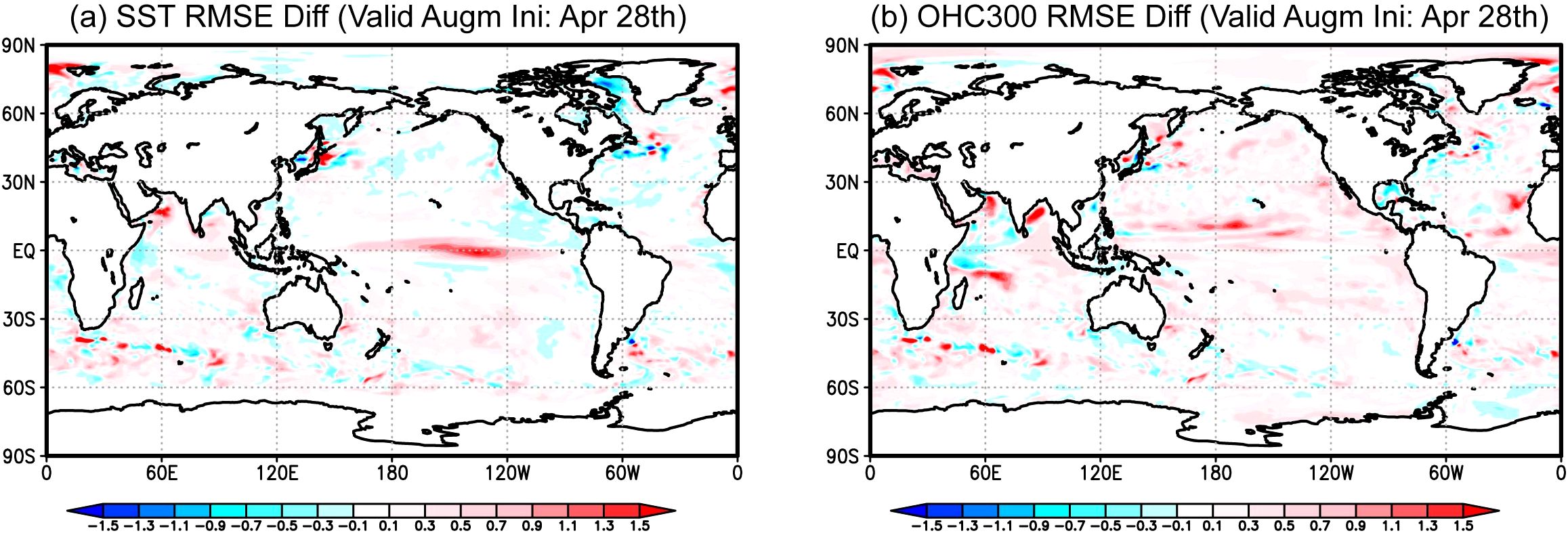
Figure 13. Reductions in the RMSEs of the (a) SST and (b) ocean heat content at 0–300 m depth (OHC300) in August in forecasts from 28 April, 2001–2016, using regular ocean reanalysis assimilating in situ temperature and salinity, and SSH and SST observations compared to the RMSEs in forecasts using ocean reanalysis assimilating only the satellite SST observations. Positive values (red colors) indicate positive impacts of in situ and satellite SSH observations. Units in °C. The lower-resolution version of the current JMA coupled prediction system was used for the forecasts.
The findings summarized above are consistent with other studies that demonstrate the value of ocean observations to seasonal forecasting. Balmaseda et al. (2024) showed that ocean observations influence the mean state, variability, and trends of ocean and atmospheric variables in ECMWF’s seasonal forecasting system. Several studies (e.g., Balmaseda and Anderson, 2009; Fujii et al., 2011; Xue et al., 2017) have highlighted the impact of Argo data on seasonal forecasts. Balan-Sarojini et al. (2024) reported unprecedented improvements in subseasonal forecasts due to Argo data, showing that removing these observations from ocean initialization systematically increases biases in oceanic and atmospheric variables during the first four weeks of forecasts. The benefits of assimilating Argo data into seasonal and subseasonal forecasts are further reinforced by coordinated Observing System Experiments (OSEs) conducted as part of the UN Ocean Decade Project Synergistic Observing Network for Ocean Prediction (SynObs) (Fujii et al., 2024; Oke et al., 2025).
Owing to their high-quality and nearly global coverage, Argo data play a fundamental role in reducing biases in coupled models and advance performance of model’s predictions through improved representation of salinity-related processes impacting climate modes such as ENSO (e.g., Zhang et al., 2021; Hackert et al., 2023; Jauregui and Chen, 2024). The reduced availability of in situ data in the tropical Pacific Ocean due to a significant reduction in tropical Pacific moorings in 2012–2014 and since 2024 has led to the degradation of the ocean reanalysis temperature fields (Fujii et al., 2015; NOAA/CPC, 2024), possibly reducing ENSO forecasts skill. Increased deployment of Argo floats in the tropical band, as planned in the OneArgo design, would therefore be highly beneficial for improving seasonal forecast accuracy in this highly dynamic and critical region (Section 5.5).
4.5 Forecasting marine ecosystems
The functioning and biodiversity of marine ecosystems, the green component of the ocean, are being severely threatened by human pressures and climate change, which are altering biogeochemical cycles and the suitability of habitats for marine species, and ultimately the livelihoods of over three billion people (UNESCO-IOC, 2021). To monitor these changes and guide efforts to mitigate and counteract them, operational centers need to develop effective forecasting systems (Link et al., 2023) and interdisciplinary Digital Twins of the Ocean (DTOs; Tzachor et al., 2023; Section 4.1). Both these approaches should be underpinned by skillful models, which can use, alternatively or in combination, ecosystem processes equations (Cossarini et al., 2024; Fennel et al., 2022) and machine learning algorithms (Skákala et al., 2023).
Marine ecosystem models, however, need multivariate ocean observations to formulate the model processes or train the algorithms, to validate the model outputs, and to initialize their forecasts via assimilation. So far, these tasks have been accomplished mainly by exploiting the abundance of satellite ocean color observations of phytoplankton Chla (IOCCG, 2020) (Section 5.3). Nevertheless systematic sensitivity experiments with research models (Wang et al., 2020) and state-of-the-art operational models (Ciavatta et al., 2025) have shown that surface Chla measurements do not help constrain ocean interior biogeochemistry. Furthermore, analysis of bio-optical data from BGC Argo shows that surface Chla measurements from ocean color satellites systematically misrepresent the phenology of plankton blooms in most of the ocean when compared to plankton biomass estimates for the euphotic zone (Stoer and Fennel, 2024). As has been pointed out previously, the sparsity of biogeochemical and biological ocean observations is hampering current forecast and simulation capabilities of state-of-the-art operational systems (Fennel et al., 2019). Marine ecosystems digital twins and forecasting tools critically depend on multi-property biogeochemical profiles that are delivered by BGC Argo for the open ocean and complemented by gliders for coastal and shelf-seas. BGC Argo data have already been shown to improve, through assimilation, state estimates of Southern Ocean biogeochemistry (Verdy and Mazloff, 2017) and, through optimized model parameterization, the simulation of carbon export in the ocean interior of the Gulf of Mexico (Wang et al., 2020).
BGC-Argo data have now reached a maturity level enabling their routine use in operational services and Digital Twin Ocean developments, demonstrating sustained performance and reliability. Mixed layer (ML)-based biogeochemical products computed by integrating worldwide BGC floats and ocean color (3D fields of particulate organic carbon, particulate backscattering coefficient and Chla concentration at depth), directly feed the European DTO’s data lake (my-ocean.dive.edito.eu; Sauzède et al., 2016, 2021), and a similar product for phytoplankton carbon biomass is feasible (Stoer and Fennel, 2024). Oxygen and Chla are already routinely assimilated or used for validation by several operational centers (https://oceanpredict.org/observations-use/#section-argo-profiling-floats). Nitrate is beginning to be assimilated into 10-day operational forecasts at the Mediterranean Sea Operational Center (Lecci et al., 2023), enabling the prediction of vertical nutrient structures that are otherwise poorly simulated and cannot be observed by satellites (Cossarini et al., 2019; Teruzzi et al., 2021).
BGC Argo floats are advancing the ocean forecasting value chain by providing fundamental data for assessing operational model accuracy and skill in representing emergent properties of marine ecosystems, such as deep Chla maxima and oxygen minimum zones (Mignot et al., 2023). In such applications, they have become an invaluable component of most Monitoring and Forecasting Centers (MFCs) of the Copernicus Marine Service, where the performance of operational models is evaluated with respect to BGC Argo observations (Lamouroux et al., 2023).
We foresee that the use of an expanding BGC Argo network will allow improvements in operational ecosystem forecasts and DTOs, also through the systematic optimization and ML-based representation of space-time variable parameters of marine processes as a function of the variability of the ocean conditions, trophic regimes and biodiversity (Skákala et al., 2024). We maintain that such an evolution will increase the capacity of models to respond to changes in ecosystem conditions and climate forcings, i.e., increase their portability across DTOs’ what-if scenarios and “self-calibrate” to strengthen the skill of forecasts by future operational centers.
5 Synergies with satellite and in situ observations
Through strong scientific synergies, the value derived from the millions of dollars invested in space-based observations of the ocean and other in situ networks, is greatly enhanced by Argo’s complementary subsurface and large-scale reach. Below we provide several examples.
5.1 Sea level budget closure
Assessing sea level budget consists of comparing total sea level change measured from altimetry satellites to the sum of all known contributions to sea level change, that are thermal expansion (thermosteric sea level) and ocean mass variations (barystatic sea level) due to ice melt from glaciers, Greenland and Antarctica, ice mass loss, terrestrial water storage, and atmospheric water vapor content (Figure 14; Section 2.2). The sea level budget is closed when the two estimates match, meaning that our understanding of sea level change is complete and consistent. Disagreement between the two estimates is indicative of missing known driving processes (due for instance to inadequate ocean observations), data inaccuracies (e.g., satellite or in situ sensor bias), or gaps in scientific understanding (Meyssignac et al., 2023).
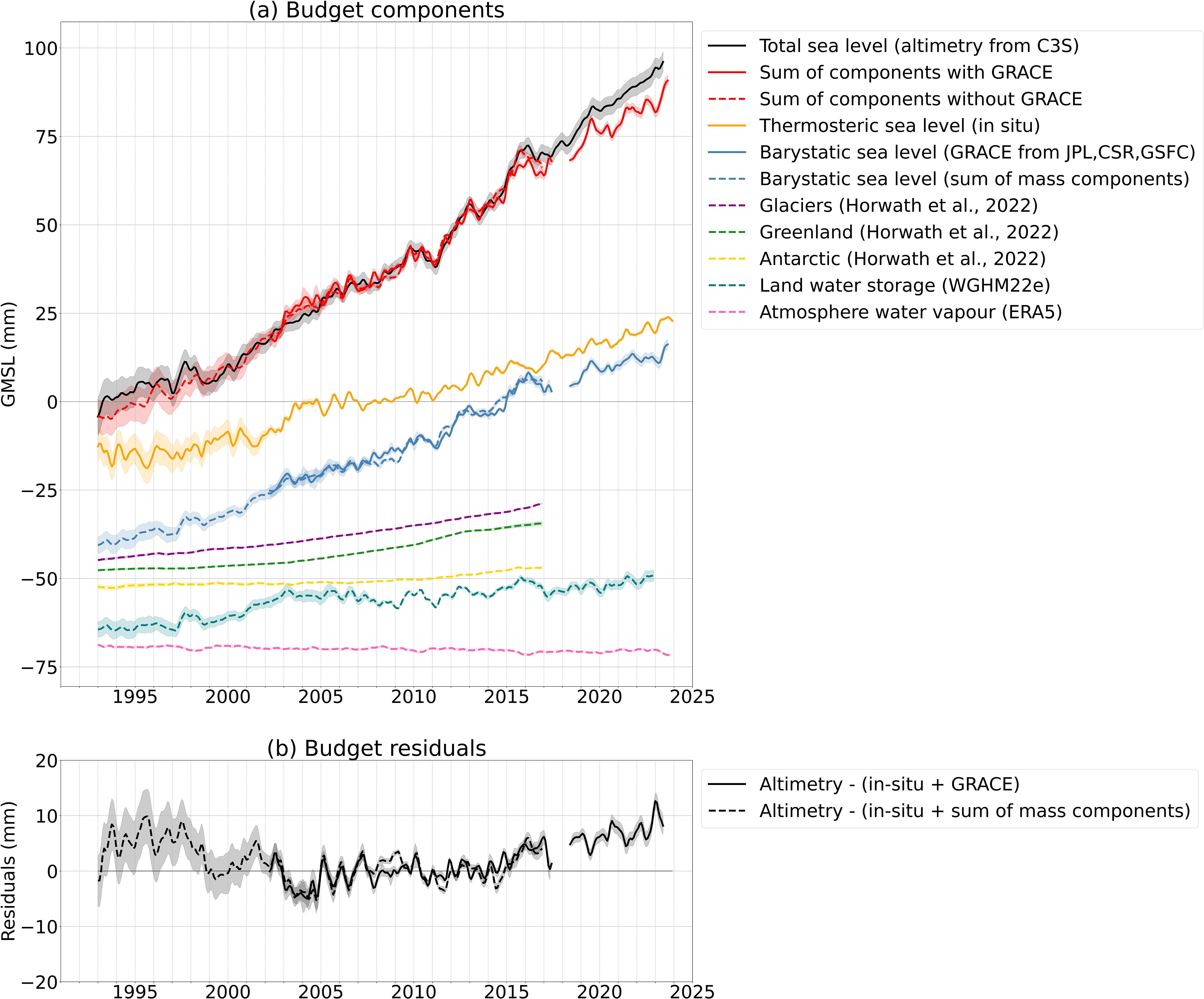
Figure 14. Sea level budget (a) from 1993 to 2023 and (b) associated residual. Total sea level (plain black line) is estimated from satellite altimetry. Barystatic sea level is estimated from GRACE and GRACE-FO (plain blue line) or from the continental water budget (dashed blue line) including glacier ice melt (dashed magenta line), Greenland (dashed green line) and Antarctica (dashed yellow line), ice mass loss and terrestrial water storage (dashed cyan line), and atmospheric water vapor content (dashed pink line). Thermal expansion (orange plain line) is estimated from in situ data including XBT, CTD and Argo profiles. The sum of the contribution to sea level and the residual are estimated using barystatic sea level from either GRACE and GRACE-FO [plain red line in panel (a) and plain black line in panel (b) or from the continental water budget (dashed red line in panel (a) and dashed black line in panel (b)].
Synergies between OneArgo and satellite observations are critical for helping close the sea level budget for several reasons. First, they ensure that all key contributors to sea level changes are accurately identified and that their combined effects match observed changes in sea level (Figure 14). This provides a thorough understanding of the mechanisms behind sea level rise (e.g. Cazenave and Moreira, 2022). Second, they serve as a validation tool for global observation systems, including the Argo network, the GRACE/GRACE-FO gravimetry missions, and satellite altimetry. By allowing sea level to be measured through multiple independent methods, synergies between OneArgo and satellite measurements help detect and correct errors and drifts in these systems (e.g. Barnoud et al., 2021). Third, closing the sea level budget helps verify the consistency of various climate measurements—such as sea level, ocean temperature, and mass—against conservation laws, ensuring that observations align with physical theories and support accurate climate modeling (e.g. Blazquez et al., 2018).
Several challenges for closing the sea level budget remain that are related to a need for more in-situ observations. The current level of precision is compatible with identifying the main contributors to sea level rise but not pinpointing contributions from deep-ocean warming below 2,000 m and from changes in land water storage (Meyssignac et al., 2023). Yet these factors are important for understanding global trends in freshwater stocks and the ocean’s ability to absorb heat and delay global warming effects. At regional scales, achieving a closed sea level budget is a challenging objective due to large uncertainties in local variations in steric sea level (see Section 2.2), particularly in the deep ocean, at high latitudes, and under ice-covered regions, as well as uncertainties in ocean heat uptake (OHU) (Cazenave et al., 2018).
The shift to the OneArgo network will address these limitations. While the current Argo float array provides valuable data for the upper half of the ocean, the OneArgo Polar mission will stretch this coverage to high-latitude and seasonally-covered ice regions, and the OneArgo Deep Argo mission will expand Argo profiling to the deep ocean, offering a better understanding of the role of the polar and deep oceans in climate dynamics.
5.2 Monitoring sea surface salinity and sea surface temperature
Sea surface salinity (SSS) and temperature (SST) are essential indicators of climate change (Section 2.1). They are key factors in the ocean’s capacity to exchange heat, water and gases with the atmosphere and thereby influence the solubility of CO2 and oxygen in seawater and the ocean’s role in the global carbon cycle (see Section 5.6). While SST influences atmospheric conditions, affecting weather patterns (Section 4.3 and 4.4), SSS provides insights into the global water cycle (Section 2.1), including evaporation, precipitation, riverine discharges and sea ice melting/freezing patterns.
Satellites and Argo measure global ocean temperature and salinity with complementary sampling characteristics. Satellite radiometers observe SSS and SST in the first centimeters or millimeters of the upper ocean, with a revisit time of 2–3 days, for observations horizontally integrated over typically 40 x 40 km2 and sampled every ~25 km (e.g., Boutin et al., 2023). Argo platforms record salinity and temperature through the water column from a few meters depth below the sea surface to thousands of meters depth, with typical vertical resolution of 2–10 m and about one vertical ocean profile per ~300 km x 300 km sampled every 10 days.
By providing the most synoptic and regular in situ observations of sub surface temperature around the globe, Argo data are a cornerstone for the validation and calibration of satellite temperature (Bhaskar et al., 2009; Gille, 2012; Alerskans et al., 2020). Similarly, Argo data are key for the validation of satellite salinity (Meissner et al., 2018) and for calibration of satellite signals with Argo-based large-scale means (e.g., basin averages or latitudinal profiles) (e.g., Boutin et al., 2021).
While Argo data do not resolve eddies directly, their colocalization with satellite observations has allowed for the resolution and interpretation of the subsurface thermohaline structure of energetic western boundary currents (Section 5.7) and eddies (Section 3.2). This has, for instance, provided a better assessment of the heat and freshwater content associated with synoptic eddies transport of the Agulhas rings (Laxenaire et al., 2019) and revealed the evolution of mesoscale structures at the ocean surface, such as Gulf Stream meanders and eddies, with unprecedented resolution (Reul et al., 2014).
The synergy between Argo data and satellite-derived SSS and SST enables significant scientific advances, such as the understanding of diurnal variability of upper ocean temperatures (Gille, 2012) and the monitoring of the marine branch of the global freshwater cycle. In this latter case, satellites and Argo were jointly used to estimate the horizontal extent of sea surface freshwater originating from river discharges, the freshwater transport integrated over the fresh surface layer and its penetration into the subsurface ocean (Olivier et al., 2024). The combination of satellite SSS and Argo data has also revealed the surface and subsurface fingerprints of major climate modes such as El Niño-Southern Oscillation (Qu and Yu, 2014) and the Indian Ocean Dipole (Du and Zhang, 2015). These phenomena have significant global impacts and affect climate patterns, precipitation, temperatures, and ocean current. Identifying their signatures at various scales (from meso- to large-scale) is instrumental for improving climate forecasts and essential for defining risk management and climate policy adaptation.
Finally, the powerful synergy between Argo and satellite-derived SSS and SST data, has enabled a better understanding of extreme events, such as heat exchanges at the air-sea interface during the passage of a cyclone, and insights into how cyclones can intensify when passing over river plumes (Reul et al., 2021), significantly improving the reliability of cyclonic forecasts.
As the effects of climate change intensify, the sustainability of the Core Argo mission and the implementation of the OneArgo extension, with enhanced sampling in western boundary currents, tropical and ice-covered Polar regions, are vital to improve SSS and SST monitoring, allowing a comprehensive understanding of ocean-atmosphere interactions and the global water cycle, as well advanced forecast of major climate modes, weather conditions and extreme events.
5.3 Synergies with satellite ocean color
Ocean color radiometry (OCR) observations from satellites have revolutionized our ability to observe marine ecosystems by providing global long-term datasets on phytoplankton dynamics, primary production, and ocean biogeochemistry (Groom et al., 2019). Since the launch of the Coastal Zone Color Scanner (CZCS) in 1978, successive missions such as SeaWiFS, MODIS, and Sentinel-3 OLCI have enhanced spectral resolution, data continuity, and accuracy. These observations are critical for monitoring climate-driven ocean changes, harmful algal blooms (HAB), or carbon fluxes.
The OneArgo BGC Argo mission, though still a young in situ observation network, has quickly demonstrated synergies with OCR. Indeed, the two types of observations complement each other in many ways: satellites offer global surface coverage at high horizontal resolution (~1 km) and near-daily temporal frequency; BGC-Argo floats provide measurements down to 2,000 meters, with a vertical resolution typically ranging from a few meters near the surface to several tens of meters at greater depth, independent of cloud cover. BGC Argo data are valuable for validating ocean color products such as chlorophyll-a (Chla), particle backscattering coefficient (bbp), and the diffuse attenuation coefficient (Haentjens et al., 2017; Xing et al., 2020; Bisson et al., 2021; Begouen Demeaux and Boss, 2022). Any discrepancies between satellite and in situ data also help identify areas that require closer inspection. New 3D or 4D products that combine satellite and float data (Sauzède et al., 2016; Figure 9) provide improved views of ocean ecosystems, helping users to track changes in productivity and carbon export crucial for understanding the global carbon cycle.
The synergy between BGC Argo and ocean color is already very strong and well demonstrated. One important mutually-beneficial development is the dawn of the era of hyperspectral observations (i.e., measurement of light across a wide range of wavelengths) of the sea, which both communities have embraced, through hyperspectral satellite missions (e.g., PACE-OCI) and BGC Argo floats equipped with light sensors that perform hyperspectral measurements (Organelli et al., 2022). These developments open up the possibility for the BGC Argo community to develop absorption-based algorithms for chlorophyll detection, and conversely, for the ocean color community to strengthen their fluorescence products. The opportunity to use hyperspectral data to investigate phytoplankton community structure is now available to both communities.
Looking ahead, the progressive deployment of a fleet of hyperspectral BGC Argo floats equipped with downwelling irradiance and upwelling radiance sensors also presents new opportunities to enhance synergy between satellite and in situ measurements. These BGC Argo floats are envisioned as versatile platforms for satellite remote sensing reflectance (Rrs) validation (Gerbi et al., 2016), complementing traditional fixed moorings. This dedicated fleet could provide a scalable, cost-effective solution for validating satellite data across diverse open-ocean conditions, improving sensor performance assessment and ensuring long-term data stability.
With the two communities working together, using both types of data to strengthen interpretation of data, the delivery of better products can be ensured. The integration of high-density, high-quality in situ datasets with synoptic satellite observations will enhance both the accuracy and applicability of global ocean monitoring effort, required for effective decision making on ocean health and risks such as HAB.
5.4 GO-SHIP
The Global Ocean Ship-Based Hydrographic Investigations Program (GO-SHIP; http://www.go-ship.org) is, like Argo, a network of the GOOS. Its design comprises 55 coast-to-coast or coast-to-ice sections (Figure 15A) on which physical, biogeochemical and ecosystem-relevant observations are made through the full depth of the water column, with each section occupied once a decade since the 1990s. The focus of the program is on the highest-quality measurements, achieved by making laboratory analyses of water samples that can be traced to internationally-agreed reference materials and best practices (Hood et al., 2010 and updates). The gathering of water samples also allows GO-SHIP to be early adopters of new parameters, such as in the nascent BioGO-SHIP program. GO-SHIP’s high-quality observations of individual parameters document the global ocean’s water mass properties and their multi-decadal evolution.
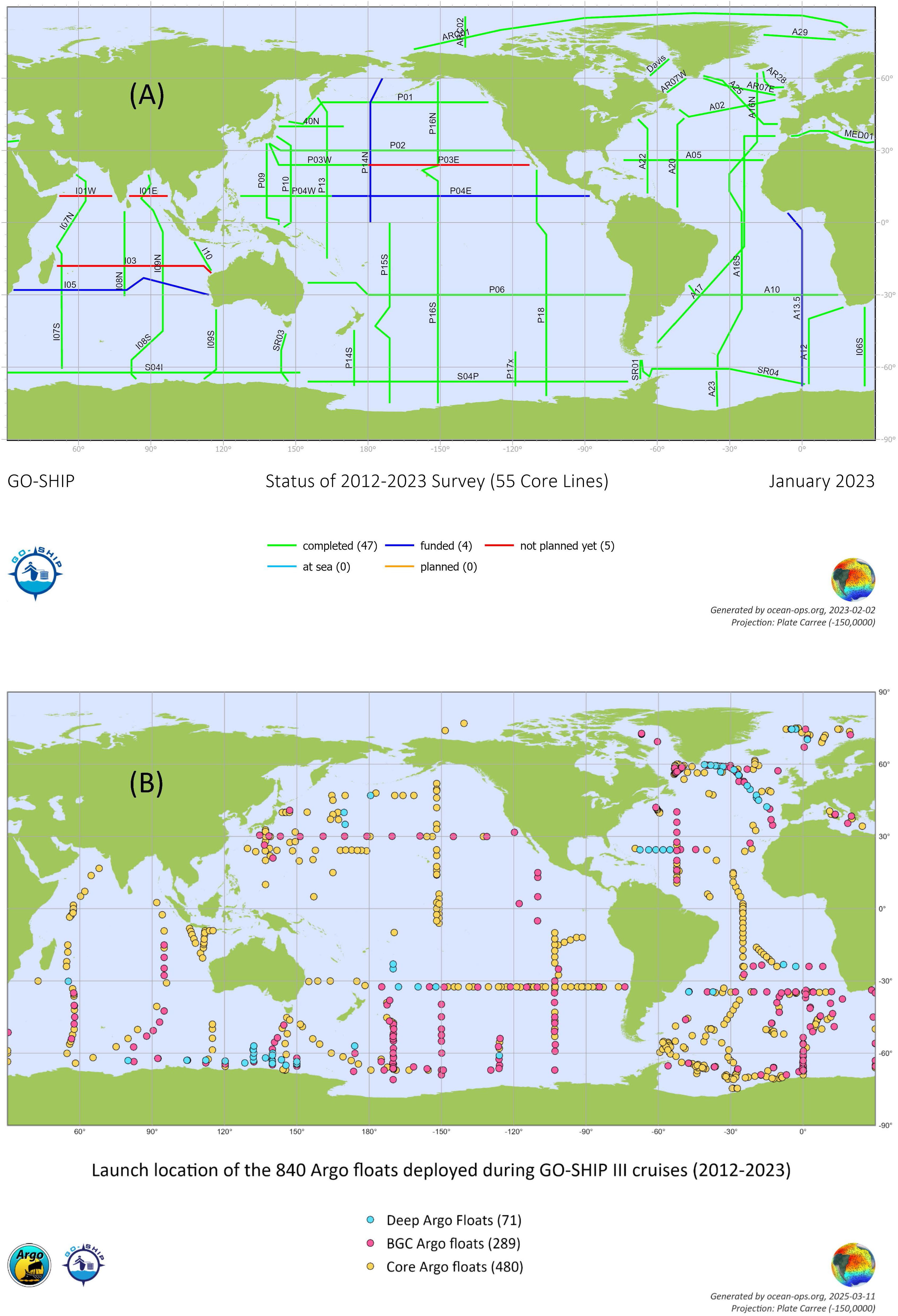
Figure 15. (A) Status of the GO-SHIP cruises of the 3rd decadal GO-SHIP survey (01/2012–01/2023). (B) Launch location of 840 Argo floats deployed from GO-SHIP cruises during this 3rd decadal GO-SHIP survey, representing ~9% of the 9,707 floats deployed during that period.
There have long been collaborations and overlaps between GO-SHIP and Argo scientists. Indeed, Argo is dependent on GO-SHIP for several aspects of its implementation. First, GO-SHIP has provided a deployment platform for Argo floats on a global scale, including in the Arctic Ocean (Figure 15B). During the 3rd GO-SHIP decade (January 2012 to January 2023), about 9% of Argo floats were deployed from GO-SHIP cruises. This number increased to about 20% when considering Deep and BGC Argo floats. Second, GO-SHIP collects high-quality measurements that are the reference data for the evaluation of Argo data quality (Wong et al., 2020). Early in Argo, these measurements were physical measurements: continuous well-calibrated vertical profiles of temperature and salinity. More recently, GO-SHIP has provided data from laboratory analysis of discrete water samples for a wide range of BioGeoChemical parameters that are also measured on floats with bio-optical and electronic sensors (e.g., Racapé et al., 2019; Maurer et al., 2021). Without these reference data, the quality of the global Argo dataset could not be assured. For the evaluation of data from Deep Argo floats, GO-SHIP provides the overwhelming majority of traceable full-depth CTD data.
The synergy between Argo and GO-SHIP is scientific as well as practical. While Argo is dependent on the logistics and data provided by GO-SHIP, Argo observes the ocean with time and space resolution that could never be achieved with ships (at least for the parameters that Argo can measure). For upper ocean temperature or salinity, the number of float profiles recorded each year is approximately 100,000, compared to around 1,000 profiles from GO-SHIP. In particular, Argo measures year-round, whereas higher-latitude ship data sampling is strongly biased towards local summer when ship operations are most feasible. GO-SHIP monitors the properties of water masses and Argo their distributions; both contribute to monitoring their evolution. The synergy between these two networks has recently been strengthened through the use of machine learning techniques such as neural networks trained on GO-SHIP data to estimate concentrations of nutrients and carbonate system parameters from temperature, salinity, and dissolved oxygen measurements (Sauzède et al., 2017). By applying neural networks to Argo data, it becomes possible to interpolate ship-based data in space and time, providing higher-resolution estimates of key oceanic variables. However, to adapt to a changing ocean, these neural networks must be regularly updated with new training data. Therefore, maintaining the availability of high-quality ship-based observations is essential to ensure the accuracy and reliability of these models over time. As discussed elsewhere, the BGC and Deep extension missions in OneArgo have not yet reached the level of activity required by the design of those missions. While Deep and BGC Argo develop, GO-SHIP remains the primary network providing climate observations for the global deep ocean, as well as the most comprehensive global source of biogeochemical data. The importance of those ship profiles for OneArgo data quality cannot be overemphasized. Whether for Core, Deep or BGC missions, Argo could not provide a climate-quality dataset without reference data from GO-SHIP. Conversely, Argo provides subsurface global, year-round, monthly coverage which cannot be achieved with measurements from ships or any other platform. Through these scientific and logistical synergies, the value of GO-SHIP and OneArgo is greatly multiplied via simultaneous and sustained implementation.
5.5 Tropical ocean moorings
Tropical oceans are home to key climate variability modes, including the El Niño-Southern Oscillation (ENSO) in the Pacific, the Indian Ocean Dipole in the Indian Ocean, and zonal and meridional modes in the Atlantic (e.g., Foltz et al., 2025). These climate modes drive lateral shifts in warm tropical waters and atmospheric convection, playing a central role in influencing global weather patterns. In the Pacific Ocean, the TAO-TRITON moored array—comprising 70 tropical moorings—was established in the 1990s, prior to the implementation of the global Argo array (McPhaden et al., 1998), with the aim to provide supplemental real-time atmospheric and oceanic measurements needed to improve understanding and forecasting of oceanic and atmospheric states, and air-sea interactions, particularly those associated with ENSO. It was followed by the deployment of the PIRATA array in the Atlantic and the RAMA array in the Indian Ocean, expanding our capacity to monitor and predict climate variability (Bourlès et al., 2019; McPhaden et al., 2009). Recent reviews of the design of the tropical moored arrays included expansion of the tropical OneArgo array, highlighting the complementary nature between the two observing systems (Smith et al., 2019; Foltz et al., 2019; Hermes et al., 2019). The doubling of Argo float coverage, and maintenance of moorings in tropical ocean basins has been recommended in these reviews (Foltz et al., 2025) to adequately measure the subsurface temperature and salinity, allowing redundancy in case of platform failure, and preserving long-term climate records. The tropical moored arrays along with the Argo observations remain a key input into seasonal climate forecasting systems (see Section 4.4), and play a critical role to challenge models and help improve their physics.
Enhancing the vertical, horizontal and temporal scales is a key objective that has strengthened the complementarity between the Argo float array and tropical ocean moorings (Cravatte et al., 2016). The Argo array provides broad global observations of temperature and salinity down to 2000 m with high vertical resolution (2 m). However, with 10-day sampling, Argo floats are not able to capture high-frequency processes. In contrast, tropical moorings are rather widely spaced, and their vertical sampling is typically 10 to 20 m (up to 5 m at the surface). Although their spatial spacing (about 15° in longitude, 2-3° in latitude) does not resolve small-scale structures such as frontal zones at the edges of the warm waters, tropical ocean moorings are uniquely able to capture high-frequency signals with hourly or better sampling, and provide collocated subsurface and meteorological observations.
At the heart of climate variability, air-sea fluxes of momentum, heat and freshwater in the near-surface layer require high resolution vertical sampling in the oceanic surface layer with co-located ocean-atmosphere measurements. For example, in tropical warm and rainy regions, mixed layer depths are often influenced by shallow salinity stratification and associated ‘barrier layers’ (Mignot et al., 2007), which affect the sea surface temperature response to wind events and may influence the onset and intensity of ENSO (Zhao et al., 2013; Zhu et al., 2014). Although barrier layers are localized and short-lived, they can impede heat transfer if they persist sufficiently for a long time over a large area (Mignot et al., 2007). Argo floats provide broad-scale information on the spatial extent of barrier layers and also offer high vertical resolution. Argo profiles also can track the displacement of the barrier layer within the eastern edge of the warm pool on intraseasonal timescales (Bosc et al., 2009), a key precursor to El Niño events. Moorings that capture high-frequency variability in barrier layer thickness, in conjunction with atmospheric measurements (e.g., wind, precipitation), provide complementary and invaluable data on these phenomena, particularly capturing short rain/convection events and diurnal cycles.
To accurately infer heat content variations at intraseasonal to interannual timescales, a mix of both Argo and moored platforms is necessary (Smith et al., 2019). The vertical spacing of mooring temperature sensors is generally adequate to follow thermocline displacements at the equator, from intraseasonal waves to interannual changes (Kessler et al., 1995; Cravatte et al., 2003). Argo floats provide additional information between the moorings at a finer meridional scale and away from the equator where zonal scales shorten. One limitation of Argo floats, however, is their inability to fully capture equatorial upwelling which is narrowly confined to the equator, whereas close fixed mooring arrays are capable of resolving this phenomena. Nonetheless, doubling Argo along the equator resolves 70–80% of the temperature variance at intraseasonal timescales at some mooring sites and more than 90% of the variance of seasonal to longer-term variability (Gasparin et al., 2015). However, for periods shorter than 20 days, the moorings continue to provide critical unique information.
5.6 Developing synergies for an integrated carbon observing system
As the ocean absorbs approximately 25% of anthropogenic CO2 emissions, a better understanding of its role as a carbon sink is critical. However, significant uncertainties persist regarding the spatial and temporal variability of this uptake. The uncertainties are largely created by gaps in traditional ship-based observational methods that are limited by weather conditions, surface coverage, and temporal resolution, while satellite-based systems see only the sea surface.
In many cases, BGC Argo observations can mitigate the observational gaps as floats can provide observations year round, in all weather conditions, in the subsurface, and in ocean regions that are infrequently visited by ships. However, the traditional observing systems provide capabilities not achievable with floats, such as traceable calibrations for each observation, measurements of many quantities that are not observable from floats, or the exceptionally high resolution of space-based observations. An optimized observing system would utilize the capabilities of each method of observation to produce products that were more detailed and capable than can be obtained from any one system of observing. Developing synergies between BGC Argo and other major observing systems would enable a vastly improved and more skillful integrated carbon observing system. It would result in enhancing our ability to monitor and understand carbon dynamics across the ocean, improving data consistency, and providing more comprehensive insights into the global carbon cycle.
By synergistically combining OneArgo, traditional ship-based approaches, and satellite remote sensing, there is thus an immense potential to significantly improve quantification of ocean carbon sources and sinks, supporting model improvements and uncovering new dynamics in carbon cycling processes. By combining the temporal and spatial coverage of autonomous floats with the precision of shipboard measurements and the high spatial resolution of satellites, OneArgo could become an indispensable component of global ocean carbon monitoring, enabling a more comprehensive understanding of the ocean’s response to growing anthropogenic pressures. While efforts should continue to foster synergies within the various components of the observation system, the essential role of OneArgo in capturing high-resolution, continuous, and multidimensional data is now indisputable. Indeed, several studies have highlighted phenomena that would have been impossible to detect using traditional methods. For instance, Carranza et al. (2024) demonstrated that extratropical cyclones in the Southern Ocean significantly enhance air-sea CO2 fluxes, while Chen et al. (2022) revealed that vertical coupling between mesopelagic waters and the surface creates basin-scale variations in CO2 exchange. Furthermore, Huang et al. (2022) highlighted the influence of biological productivity on air-sea CO2 fluxes by leveraging sensors for oxygen, pH, chlorophyll, and particle backscatter. BGC Argo observations of dissolved oxygen enable global maps of biological carbon cycling (Yamaguchi et al., 2024), the driver of the biological carbon pump that produces a large reduction in atmospheric carbon dioxide levels.
5.7 The role of Argo in developing synergies for western boundary current monitoring
Western boundary currents (WBCs) are swift and narrow jets flowing along the western boundaries of ocean basins in both hemispheres. They are a key component of the global ocean circulation system (Section 3.1) and play an influential role in ocean heat transport, influencing climate patterns, affecting fishing stocks, biodiversity, coastal sea level, rainfall, and storm activity. Nonetheless, the direct observation of WBCs is challenging due to the difficulty of maintaining, within these energetic current regimes, observing platforms that successfully capture the wide range of temporal and spatial scales of variability. WBC monitoring cannot be achieved by a single ocean observing platform but instead, requires a combination of complementary long-term platforms, such as moorings, glider and high-resolution XBT transects, high-frequency radar and drifters (Todd et al., 2019; Ayoub et al., 2024). Argo floats provide broad coverage in WBCs but to date the year-to-year sampling density has been heterogeneous as the floats tend to get caught in fast-flowing jets. Yet Argo data assimilation has been shown to strengthen WBCs in ocean models, even though Argo data is sparse at the boundaries (Oke et al., 2019). This is likely because of the better temperature and salinity representation on the interior side of the boundaries. OneArgo plans to double the density of float deployments within WBCs over the next decade (Roemmich et al., 2019). Through this intentional decision, the Argo community has the opportunity to step forward and take a lead in the design and implementation of a sustained boundary current monitoring scheme. In addition, OneArgo has previously dealt with the geopolitical challenges of requesting permission to deploy and sample within the EEZs of multiple countries, and hence could provide insight into this issue also faced in boundary current monitoring (GOOS, 2021). Similarly, the global Argo network has prior experience useful for guiding the securing of resources and funding, as well as fostering a framework for the international and regional cooperation that is vital for sustained WBC observations. Some good examples of what the sustainably-funded infrastructure for WBC observing might look like are already described in Ayoub et al. (2024). Continued integration of WBC monitoring observations that will be of benefit to society, cost-effective for investors, and guide the evolution of the observing system through end-user engagement, is pivotal to advance our ability to improve climate monitoring and model evaluation.
5.8 Bathymetry
Accurate charting of ocean bathymetry is fundamental to understanding and predicting large-scale ocean circulation (Rahman and Rahaman, 2024), tidal propagation and dissipation (Arbic, 2022), ocean mixing (Mashayek et al., 2024), and tsunami and storm surge impacts on coastal regions (Latifah et al., 2024; Zhang et al., 2024). Detailed maps of shape and depth fluctuations of the ocean floor are essential for navigation safety (Mavraeidopoulos et al., 2017), simulation of high-seas fishery catch (Guiet et al., 2024), and assessment of offshore energy platform vulnerability (Alizadeh et al., 2024).
To date, the gold standard method for measuring ocean bathymetry uses the time of propagation of a sounding signal sent from a shipboard echosounder to the seafloor (Wölfl et al., 2019). Yet basin-scale echosounding surveys remain limited and only 26.1% of the ocean floor is currently sampled using this technique (GEBCO Bathymetric Compilation Group, 2024). An alternative method utilizes the slope of the ocean surface from satellites to estimate ocean bathymetry, but has a lower spatial resolution than echosounding measurements (Tozer et al., 2019).
Ocean bathymetry is a new application of the OneArgo mission. The seafloor is detected by a float when the pressure sent by the CTD sensor to the float controller shows no increase despite attempts from the buoyancy system to descend to greater pressure depth. Core Argo floats may reach the bottom in shallow (< 2,000 m) regions near the coastline. Early validation of 2,000-meter capable Argo data shows good consistency with multibeam echosounders in the Antarctic continental shelf (van Wijk et al., 2022b), a region where accurate knowledge of bathymetry is of critical importance to assessing the present and future contribution of Antarctica to sea level rise. About 2/3 of historical Deep Argo profiles reveal detection of the seafloor in the deepest (3,000–6,000 m) regions of the ocean interior. The proportion of Deep Argo profiles detecting the ocean floor can be increased by setting the maximum profiling pressure to exceed the expected depth. Deep Argo floats can collect higher-resolution bathymetric data than satellites over widespread and remote regions of the Atlantic, Pacific, and Southern Oceans (Zilberman et al., 2023a; Yu et al., 2024), where ship-based acquisition of bathymetric sounding is typically lacking. Core Argo and Deep Argo data have been already assimilated in the Bathymetric Chart of the Oceans since 2024 (GEBCO Bathymetric Compilation Group, 2024; Jakobsson et al., 2024), and are attributed a Type Identifier (TID) code of 47 in GEBCO grids starting in 2025 and going forward. With each float sampling remote ocean areas every 10 days over a lifetime of 5–8 years, OneArgo has the capacity to rapidly densify ocean bathymetry sampling in all ocean basins and play an important role in the advancement of Seabed 2030, a program of the UN Decade of Ocean Science for Sustainable Development (2021–2030) dedicated to increasing the spatial resolution of the ocean floor by way of collating supplemental observations and developing new platforms (Mayer et al., 2018).
6 Ocean observation to support ocean management
6.1 Fisheries
Global fisheries and aquaculture production was estimated as 223.2 million tons in 2022, corresponding to 195 billion USD for the international trade of aquatic products and supporting the employment of 61.8 million people (FAO, 2024). Global capture fisheries production has remained stable since the late 1980s, but the sustainability of fishery resources is a cause for concern, while global demand for aquatic foods is projected to increase further (FAO, 2024).
The population models applied in fishery management approaches typically assume that fluctuations in the vital rates of a fish population are centered on a stationary mean, derived from the system’s past behavior. Assessments of stocks also include assumptions about the spatial distribution of fish and their habitats. This style of fishery management originated when reliable, low-latency observations of upper ocean conditions were desired but unavailable at the necessary space and time scales. Thus, most fish population models exclude consideration of environmental context (Skern-Mauritzen et al., 2016). Even with such information, more research is needed to mechanistically link environmental conditions to fish population dynamics in a way that is useful for living marine resource management (Cowan et al., 2012). Still, it has long been recognized that climate change is impacting the structure and functioning of marine ecosystems, and that management approaches based on assumptions of stationarity are not ideal.
The first step toward environmentally-informed, dynamic fishery management is comprehensive ocean monitoring, with low-latency data dissemination. This will enable the foundational research required to connect transient environmental conditions to ecosystem and population modeling (Schmidt et al., 2019). Such advances could be achieved with the envisioned OneArgo array that would provide globally-distributed observations of ocean physical (pressure, temperature, and conductivity), chemical (oxygen, nitrate, and pH), and biological (particle backscatter, chlorophyll fluorescence, and light) conditions throughout the upper ocean in near-real time (Roemmich et al., 2019). Global Argo data synthesis products provided on regular time and space grids (e.g., Roemmich and Gilson, 2009) that are routinely updated (i.e., ≥ monthly frequency) will be the most valuable to end users in fishery science and management who do not have the time or expertise to wrangle inconsistent and complex datasets from outside their discipline. For example, satellite ocean color data with unprecedented spatial coverage have been used widely in fisheries research; however, their utility for operational needs has been limited by seasonal gaps in spatial coverage and the restriction of observations to the sea surface. By combining ocean color and Argo data (Section 5.3), many global-scale observing challenges can be overcome, yielding low-latency marine environmental information throughout the upper 2,000 m of the global ocean (e.g., Sauzède et al., 2016; Sharp et al., 2023).
Operational four-dimensional global ocean data products will enable low-latency mapping of habitat ranges associated with the life stages of fish, mammals, and turtles based on their preferred environmental conditions. This in turn will improve the collection of biological data for stock assessments and the efficiency of commercial fisheries by facilitating distribution estimates of target fish and species of concern. Environmentally-informed and proactive decision-making will expedite closure warnings so that adaptive measures can be taken to mitigate the impacts to fishing community livelihoods. While many fisheries are centered on the continental shelves where Argo floats typically do not profile and optically complex waters cause satellite algorithms to break down, important lifecycle stages of many migratory species that are fished nearshore take place in the open ocean. Integrating coastal observing system data into the nascent global Argo-based data products currently under development will help connect large-scale oceanographic conditions to local social-ecological system dynamics, extending the value of Argo into coastal and estuarine domains.
6.2 Marine carbon dioxide removal approaches
Carbon dioxide removal refers to a set of technologies or methods used to remove CO2 from the atmosphere and store it in various forms to mitigate climate change. Notably, the deployment of marine CO2 removal techniques (mCDR; e.g. alkalinization, fertilization) for the open ocean is increasingly considered as a promising strategy to enhance the natural carbon sequestration capacity of the oceans (NASEM, 2022). OneArgo has the unique potential to become the cornerstone of an ocean observation system required for the evaluation of such mCDR manipulations in offshore waters, particularly through its BGC Argo mission (Boyd et al., 2023a). The float platform has the versatility required to observe different open ocean mCDR methods, through key variables that are already routinely measured (pH, oxygen, bio-optical variables), and it can accommodate additional sensors (e.g., for the carbonate system; Bushinsky et al., 2019) as soon as they reach technological maturity. The OneArgo program, by already meeting most of the desirable characteristics for monitoring, verification and reporting (MRV) for the deployment of ocean-based mCDR, makes it unnecessary to develop a costly ad hoc system for MRV. However, and despite its huge potential, the OneArgo system is not yet ready—only half of the network has been implemented and additional sensors must be developed or optimized. In advance of any ocean-based mCDR deployments at a scale that will influence atmospheric concentrations, it is therefore essential and urgent to complete, through sustained funding, the full implementation of OneArgo and its BGC component (Boyd et al., 2023b). Such full implementation is the prerequisite to establish a robust benchmark of the ocean biogeochemical state. Benchmarks would also drive improved understanding of natural variability, such as seasonal or interannual changes, and consequently more confident attribution of observed changes resulting from ocean-based mCDR deployments, while accounting for other natural processes affecting the carbon cycle. Furthermore, the cost, scalability and interoperability of OneArgo make it a candidate to accommodate a range of scales from local (pilot and research project) to regional (mCDR trials and scaled-up deployments) to global (dispersal of mCDR from repeated deployments).
In summary, a long-term OneArgo array having the capability to accommodate new measurements is a fundamental pillar for ensuring that ocean-based climate mitigation efforts can be rigorously evaluated, thus safeguarding the scientific credibility of ocean mCDR projects.
6.3 Deep-sea mining
Deep-sea mining (DSM) refers to the extraction of mineral resources from the ocean floor at depths exceeding 200 meters. While it offers access to valuable deposits of critical metals such as lithium, nickel, copper, and cobalt, it remains highly controversial due to the environmental risk it poses to this pristine and largely unexplored region (Boetius and Haeckel, 2018; Vonnahme et al., 2020; Macheriotou et al., 2020). Given the complexity of understanding and mitigating its environmental impact, scientific consensus on the feasibility of large-scale DSM is unlikely (Amon et al., 2022). Beyond these unpredictable risks, there is a broader argument to permanently preserve the deep seabed environment, given there are abundant metal resources on land (Crane et al., 2024).
Despite these concerns, DSM tests are already underway. Consequently, there is a pressing need for further independent study of the natural properties of the deep ocean to provide more evidence of how they would be disrupted by DSM, to uphold precaution surrounding DSM and raise public awareness regarding the unique and fragile nature of the deep-ocean environment.
BGC Argo floats and their associated sensors are invaluable to understand the natural variability of the mesopelagic zone (100–2,000 m) and its susceptibility to perturbation by DSM (Drazen et al., 2020). At greater depths, the natural properties of the water column near the deep-ocean floor could be monitored by Deep Argo floats (down to ~6,000 m) equipped with biogeochemical sensors, in order to widen essential understanding about the natural processes that sustain these unique ecosystems.
Given the largely unexplored nature of the deep ocean, deploying Argo floats in proposed DSM areas is a vital step toward documenting natural processes and assessing their susceptibility to DSM. Such efforts can help maintain a precautionary approach by grounding decisions in robust, independent science. By using OneArgo data to further understand the deep ocean’s intricate biogeochemical processes, its ecological fragility, and its potential for biotechnological and medical discoveries (Boetius and Haeckel, 2018), researchers can strengthen the case for protecting this unique environment.
6.4 High seas marine protected areas and biodiversity beyond national jurisdiction treaty
Efforts to conserve Biodiversity Beyond National Jurisdictions (BBNJ) have gained momentum, culminating in a United Nations treaty to safeguard the world’s oceans (Tessnow-von Wysocki and Vadrot, 2020), the BBNJ Agreement. This treaty aims to protect marine ecosystems, conserve biodiversity, and establish Marine Protected Areas (MPAs) in the high seas. The development of science-informed guidance for managing such Areas Beyond National Jurisdiction (ABNJ) relies on advanced observation systems like the Argo program, which can provide critical data for governance and conservation.
One prominent example is the Ross Sea MPA, the world’s largest high-seas MPA (2.09 million km²). Its objectives include conserving biodiversity, protecting key species and ecosystems, and serving as a reference for studying environmental changes and human impacts (Brooks et al., 2021). Although BGC Argo deployments in the Ross Sea have been limited, they have successfully captured carbon and nutrient fluxes throughout a full annual cycle in ice-covered areas—data unattainable via traditional methods (Cao et al., 2025). Expanded deployment of floats within the MPA could provide critical insights into nutrient and carbon cycles, krill biomass, and the broader food web, on time and spatial scales that are appropriate. Emerging technologies, such as the Underwater Vision Profiler (Picheral et al., 2022) or miniature echosounders (see Section 2.6), could further enhance observations, especially for macroplankton and species like Antarctic silverfish, supporting science-based governance of this complex and variable ecosystem.
Similarly, the Central American Thermal Dome, located in the eastern Tropical Pacific, is recognized by UNESCO as a high-seas site of exceptional heritage value. This biodiversity hotspot and socio-economic hub supports migratory marine predators, rich fishery resources, and commercial shipping routes. It is poised to become one of the first ABNJ to be protected. The Argo-Dome project (https://argo-dome.org) has begun prototyping an ocean observation system using next-generation BGC Argo floats to generate multidisciplinary data (physical, biological, biogeochemical, acoustic, and optical). This system aims to provide the foundational knowledge required to guide future conservation measures and governance for the Dome’s protection.
Both examples illustrate the critical role of BGC Argo floats within the OneArgo program in bridging observational gaps, providing essential data on oceanic processes, and enabling evidence-based governance of ABNJs. As these technologies advance, they will play a central role in informing and supporting effective global ocean governance, ensuring the protection of biodiversity and the sustainable use of marine resources in the high seas.
7 OneArgo related to societal concerns and needs
7.1 Environmental footprint of Argo
Argo floats are quiet and robust autonomous platforms designed to be as energy-efficient as possible (Davis et al., 2001; Le Reste et al., 2016; Riser et al., 2018). In light of these assets, there is presently no method for observing the global subsurface ocean that is more cost-effective and less environmentally damaging than Argo (Argo Program Office et al., 2020). Floats are primarily deployed from research vessels during scientific cruises, commercial ships or, occasionally, through partnerships with civil society initiatives (such as Vendée Globe, 2024). By leveraging existing maritime routes, this approach minimizes the need for dedicated ship time and its associated fuel consumption. Standard floats operate at sea for 5 to 8 years, and continuous efforts by the scientific community and manufacturers focus on extending their lifespan, improving energy efficiency and enhancing sensor reliability (Gordon et al., 2016; Dever et al., 2022). The design and implementation of OneArgo further optimizes (Johnson et al., 2015; Chamberlain et al., 2023) the required deployment rate of new floats while ensuring adequate ocean sampling coverage for all Argo-measured ocean variables across different regions.
Although Argo floats have very minimal environmental impact (Argo Program Office et al., 2020), their loss at sea at the end of their lifespan remains a concern for the Argo community. Building on successful initiatives, primarily in European seas (D’Ortenzio et al., 2020; Walczowski et al., 2020), efforts to recover Argo floats have significantly increased. Currently, around 10% of European floats are routinely retrieved during scientific cruises or through opportunistic ship transits. Another potential approach involves chartering dedicated float recovery cruises when economically and environmentally viable. For instance, a proof-of-concept cruise using a low-carbon footprint vessel (Euro-Argo ERIC and Ifremer, 2024) demonstrated that collaborations with civil society could effectively support float recovery operations. Recent studies (González-Santana et al., 2023) reveal the potential to extend recovery efforts to other regions and involve different stakeholders, such as fishing vessels. Current priorities include developing best practices for float recovery, reconditioning floats for redeployments, and determining recycling pathways for components when reconditioning is not feasible. Additionally, assessing the human resources required to coordinate recovery and reconditioning activities is a key focus. The European implementers aim to recover 25% of their annual deployments by 2030, while simultaneously developing a global strategy for OneArgo that considers the unique characteristics of each ocean basin. Particular attention is being given to ensuring access to low-carbon footprint vessels, factoring in distance from the coast, infrastructure availability, and oceanic and weather conditions.
Expanding Argo to OneArgo involves increased costs as well as greater scientific and technical complexities. Recovery of floats stands to not only further drive our efforts to lower Argo impact on the environment, but also generate economic (e.g., through refurbishment), scientific (e.g., post-calibration of sensors) and technical (e.g., expertise on floats) value to the program. In addition, the Argo community will work towards adopting more environmentally benign batteries as they become available.
7.2 OneArgo and its societal benefit through ocean literacy and education
At present, we can state countless examples for strong bonds in the science to society domains such as technological innovation and knowledge transfer, and governance. Other examples, however, show a skepticism regarding science, its approaches and results or a lack in people’s scientific understanding (e.g. IFOP, 2023). Current studies show for example a staggering 59% of respondents between the age of 16 and 25 are climate-anxious and are extremely worried about climate change and how this will impact their futures (Hickman et al., 2021). It is thus more important than ever to foster a science-literate society that can engage in meaningful discussions, make informed and responsible decisions and help prepare a vibrant future for the next generations. Consequently, and regarding the Ocean and its critical role in sustaining life on Earth, the Ocean literacy movement is very crucial.
Ocean literacy is rooted in sciences and yet it is so much more than a transfer or exchange of knowledge (McKinley et al., 2023); it is about developing the skills, values and culture needed to engage with Ocean issues at every socially relevant level. A strong Ocean education component encourages lifelong learning, both formal and informal, and helps to connect people with the Ocean and its resources.
The OneArgo community subscribes to the ambition to enhance Ocean literacy and education. They contribute with targeted actions, all well-founded on the combination of cutting-edge research and innovative technology to monitor and explore the Ocean. Such actions mostly combine science communication and mediation techniques and address a mainly non-scientific audience. Actions of the international OneArgo network have a local to global reach and several are truly collaborative engagements (e.g. Greenan et al., 2023; article translations in more than a dozen languages available online).
For almost two decades now, OneArgo community members have been designing, developing and putting in place actions that bridge between science and society. In their approach, a strong focus is given to guarantee interactions with a young public. For example, through hands-on experiences and educational resources, school children around the world benefit from the pluridisciplinary and multifaceted program and the freely accessible data provided in real time. For students and early career scientists, professional development initiatives are ongoing to expand expertise within the fields of physical and biogeochemical oceanography as well as science communication and mediation.
On top of such educational initiatives, the One Argo community extends actions outside of schools and academia to reach out to emerging small and medium enterprises keen to develop sensor technologies that can be integrated onto Argo floats, policy and decision-makers responsible for high-level decisions, but also importantly, society at large. These interactions are intended to promote and cultivate science-to-society links, to give the (present and upcoming) generation in charge of big and small decisions access to actual science-based information and foster their awareness of today’s challenges.
7.3 Capacity building
Capacity building is needed at all levels of OneArgo. Developing and sharing technical expertise on Argo floats and sensors are required both for new instrument development and diversification, and for the monitoring of floats (Cancouët et al., 2020) and sensor behavior at sea, to avoid potential failures in the network and associated datasets. Building capacity through new partnerships is essential to maintain regular deployments of floats across the global ocean, including in high-latitude regions and undersampled areas, and to increase the number of recovered floats (González-Santana et al., 2023). Data centers also need to scale up their infrastructure and expertise in order to manage the larger amount and variety of data to be processed, qualified and distributed.
The Argo community, comprising all individuals involved in the network implementation, from instrument development through to the provision of qualified data to users, has been growing since the early 2000s. International efforts to establish and share best practices for collecting and analyzing Argo data have culminated in two recent publications: Bittig et al. (2019) and Morris et al. (2024).
Efforts devoted to community training have contributed to the success of Argo and its development towards OneArgo (Roemmich et al., 2019). There is a large base of scientific and technical experts in the international Argo community willing to share their expertise and help new countries and individuals to contribute, operate floats, manage and access Argo data. Events such as workshops, training sessions and summer schools are occasionally organized, targeting individuals entering the Argo community within existing Argo teams, scientists outside Argo national programs, or students in oceanography or related fields. Recent examples include a BGC Argo training course organized by POGO (Partnership for Observation of the Global Ocean) in China and the EuroFleet+ floating University in Italy. The deployment of Argo floats during the 2024 Vendée Globe sailing race and the NAARCO sailing cruise devoted to float recoveries (Section 7.1) are other examples, which highlight capabilities transfer towards civil society. In addition, several “float donor programs” have been implemented in the last two decades to kick off new contributions in Asia, South America and Africa. In Europe, countries involved in Argo are organized within the Euro-Argo European Research Infrastructure Consortium (ERIC), which provides a remarkable framework for capacity building, through collaboration between the ERIC members, and activities led at regional level (Kassis et al., 2021; Walczowski et al., 2021). Actions are also undertaken at international level to upgrade the skills and knowledge of part of the existing Argo community in the domains required by the OneArgo extension (Deep Argo, BGC Argo and Polar Argo missions). Technical workshops where Argo’s industrial partners work with expert and non-expert float deploying teams to exchange practices and issues have been invaluable. The Argo Data Management Team has been particularly active since the start of the Argo program, sharing documents, tools and codes (https://github.com/euroargodev/Argo-data-management-documents; https://argo.ucsd.edu/data/argo-software-tools/), and continues its efforts within the OneArgo framework.
The Argo community has proved its ability to set up some internal mechanisms for capacity building development. Argo is also active in capacity building activities outside the Argo community itself through: (i) knowledge exchange with other observing networks, occurring in various contexts (e.g. GOOS Observations Coordination Group, Data Buoy Cooperation Panel, EuroGOOS and EU-funded projects in Europe) and (ii) outreach about Argo data access, format and flow, aimed at the external user community (e.g. González-Santana and Velez-Belchi, 2024), which is key for the program to achieve a high societal impact (Section 7.2).
Argo capacity building initiatives have been made regularly but in an ad hoc and opportunistic way. They deserve a more organized and routine approach, supported by resources dedicated to transferring floats and expertise to new partners and gradually augmenting the already large base of Argo implementers and users.
8 Summary and future crucial needs
The ocean provides functions essential to society. It influences weather conditions, moderates climate change, hosts massive biodiversity and supports human livelihoods, and is vital to the global economy, through industries such as offshore oil and gas, marine renewable energies, fisheries, aquaculture, maritime transportation, and tourism. Changes in the ocean state therefore have profound impacts on human health, well-being and safety. Scientific reports and numerical predictions are unsettling, indicating clear signs of deterioration of the ocean’s health. Ocean warming alters weather and climate, exacerbating the magnitude and frequency of extreme events such as heatwaves, wildfires and storm surges. These changes amplify risks of riverine and coastal flooding, intensify coastal erosion, and impact water access, agricultural productivity, infrastructure development, housing markets, and property insurance. Additionally, ocean warming combined with ocean deoxygenation and ocean acidification along with fishing pressure is impacting marine ecosystems, endangering fish stocks, biodiversity, and aquaculture. While diagnosing symptoms of ocean health decline is essential, identifying their causes and predicting future changes are critical to developing effective solutions and mitigation options.
OneArgo represents a transformative step toward improving our ability to understand and predict ocean variability by integrating physical, chemical, and biological observations. Core Argo and the emergence of the Deep, BGC, and Polar missions have already enabled scientific breakthroughs in our understanding of sea level change, ocean warming, circulation, deoxygenation, acidification, and the interplay of these phenomena. Emerging applications are being explored to advance knowledge on ocean mixing, ocean bathymetry and sediment transport, define ecosystem resilience, and assess the impact of ocean-based climate mitigation efforts such as marine carbon dioxide removal experimentations. By enabling continuous ocean state assessment, OneArgo enhances ocean and weather forecasts, improves extreme weather and ocean event predictions, and refines climate change projections. OneArgo also provides critical insights into sea level rise, coastal flooding, and oceanic ecosystem changes, reinforcing the safety of the populations and the prosperity of the ocean economy.
As the ocean economy continues to grow, its full potential can only be unlocked through a stable and sustained ocean observation system supporting key information services. Without a comprehensive baseline of the physical and biogeochemical state of the open ocean, ocean-based industries cannot effectively achieve long-term prospects for global economic growth. Investing in a robust ocean observing infrastructure is not just a scientific necessity, but an economic imperative. The ocean economy must recognize that upstream investment in sustained ocean monitoring will generate downstream direct economic returns and innovations.
However, despite its immense societal value and recognition within the scientific community, OneArgo remains only partially funded and on a short term basis. The full realization of OneArgo requires sustained and much increased investment over the original core mission. This means transitioning from a project-based funding model to a more institutionalized, long-term approach, comparable to meteorological observation systems, which have benefited from sustained public and private investment. To reach this objective, it is essential to strengthen top-down governance, highlight the societal and economic benefits of ocean observation, and foster greater political commitment to secure long-term funding of ocean observation, as advocated, coordinated by, and supported through the Global Ocean Observing System (GOOS).
Due to the hard-won underpinning work done to date, with the right scale up in resources the Argo community can achieve the global implementation of the OneArgo float array within the next five years. This effort will include ramping up float production, optimizing sensor performance and float longevity, diversifying suppliers to support sustainability, and expanding deployment and recovery opportunities via high-seas research, commercial and sailing vessels to maximize cost-effectiveness and reduce environmental footprint. Facilitating marine science research clearance in EEZs will be instrumental to advance homogeneous sampling. Strengthening synergies with ocean in-situ and satellite observing networks will be prioritized to increase OneArgo’s scientific value. Additionally, enhancing data accessibility and developing new user-oriented products will be crucial for maximizing economic and societal benefits, supporting key industries such as fisheries, aquaculture, maritime operations, and developing climate adaptation strategies.
Without strong and sustained support to implement OneArgo by 2030 while maintaining the Core Argo mission, past successes come under threat, and the transformative opportunities ahead cannot be fully realized. In the event that supplemental funding would not be provided, the target date for the implementation of OneArgo would be delayed. The number of Core Argo floats would be reduced but the number of 0-2,000 meter temperature and salinity profiles, including those provided by Deep and BGC, would be maintained. Argo has consistently positioned scientists and stakeholders at the forefront of ocean science and technology. Securing OneArgo’s future will not only extend this leadership, but also provide decision-makers with the critical knowledge needed to navigate unprecedented environmental challenges. Beyond its scientific necessity, investing in OneArgo is a strategic and cost-effective imperative to safeguard ocean health, economy and human wellbeing for generations to come.
Author contributions
VT: Writing – original draft, Conceptualization, Writing – review & editing, Supervision, Investigation. HC: Writing – review & editing, Writing – original draft, Conceptualization, Investigation. OP: Writing – original draft, Investigation, Writing – review & editing. NZ: Investigation, Writing – review & editing, Writing – original draft. KJ: Writing – review & editing, Writing – original draft. BK: Writing – review & editing. SW: Writing – review & editing, Writing – original draft. UB: Writing – review & editing. MBa: Writing – original draft. MBe: Writing – original draft. MBo: Writing – original draft. JB: Writing – original draft. PB: Writing – original draft. RCa: Writing – original draft. FC: Writing – review & editing. SCi: Writing – original draft. RCr: Writing – original draft. SCr: Writing – original draft. GD’O: Writing – original draft, Writing – review & editing. DD: Writing – original draft. PD: Writing – original draft. AF: Writing – review & editing, Writing – original draft. KF: Writing – original draft. YF: Writing – original draft. FG: Writing – original draft. AG-S: Writing – original draft. CG: Writing – original draft. AG: Writing – original draft. HH: Writing – original draft. SJ: Writing – original draft. GJ: Writing – review & editing, Writing – original draft. NK: Writing – original draft, Writing – review & editing. AL: Writing – original draft. P-YL: Writing – original draft. WL: Writing – original draft. ML: Writing – original draft. JL: Writing – original draft. EM: Writing – original draft. AM: Writing – original draft. BM: Writing – original draft. KM: Writing – original draft. TM: Writing – original draft. PO: Writing – original draft, Writing – review & editing. WS: Writing – original draft. BO: Writing – review & editing. NP: Writing – original draft. JP: Writing – review & editing. RR: Writing – original draft. DR: Writing – review & editing. SS: Writing – original draft. MS: Writing – review & editing. CS: Writing – original draft. OS: Writing – original draft. KV: Writing – original draft. JSc: Writing – original draft. JSp: Writing – original draft. TS: Writing – original draft. MT: Writing – original draft. EV: Writing – review & editing, Writing – original draft. XX: Writing – review & editing. HZ: Writing – original draft.
Funding
The author(s) declare that financial support was received for the research and/or publication of this article. VT gratefully acknowledges financial support from the following projects and grants: the Equipex+ Argo-2030 project supported by the French government under the “Investissements d’avenir” program within France 2030 and managed by the Agence Nationale de la Recherche (ANR) under grant agreement no. ANR-21-ESRE-0019; the CPER Obsocean, co-funded by the European Union, Région Bretagne, Département du Finistère, Brest Métropole, and Ifremer; and the Euro-Argo ONE project funded by the European Union's Horizon Europe research and innovation programme under grant agreement no. 101188133. HC acknowledges financial support from the European Research Council (ERC) for the “REFINE—Robots Explore Plankton-drive Fluxes in the Marine Twilight Zone” project (grant agreement 834177) and from the Centre National d’Étude Spatiale (CNES) for the BGC-Argo TOSCA project. NZ acknowledges support from the NOAA Global Ocean Monitoring and Observing Program through Award NA20OAR4320278, and additional support from NSF (OCE-2242742) and Seabed2030 (UNH2042102). MS acknowledges support from the NOAA Global Ocean Monitoring and Observing Program (NA20OAR4320278) and Seabed2030 (UNH2042102). SRJ, WBO, and SEW were supported by the NOAA Global Ocean Monitoring and Observing Program through CINAR Award grant #NA19OAR4320074. KJ acknowledges support from US National Science Foundation projects Southern Ocean Carbon and Climate Observations and Modeling (NSF PLR-1425989, OPP-1936222, and OPP-2332379) and the Global Ocean Biogeochemical Array (NSF OCE-1946578), and support from the David and Lucile Packard Foundation. NK was supported by the Service National d'Observation (SNO) Argo France (INSU/CNRS/UBO). XX is supported by Laoshan Laboratory (LSKJ202201500). SS was supported National Centre for Earth Observation (UK). DR, JS, and MS acknowledge support from the NOAA Global Ocean Monitoring and Observing Program (NA20OAR4320278), with MS also receiving support from Seabed2030 (UNH2042102). GCJ and JML were funded by the NOAA Global Ocean Monitoring and Observation Program and NOAA Research. AJF was supported by the NOAA Pacific Marine Environmental Laboratory, and both AJF and RRR received support from the NOAA National Marine Fisheries Service Essential Data Acquisition Strategic Initiative on Remote Sensing through the Inflation Reduction Act. MSL acknowledges support from the Physical Oceanography Program of the U.S. National Science Foundation through grant OCE-1948335. The work of P.J.D. from Lawrence Livermore National Laboratory (LLNL) is supported by the Regional and Global Model Analysis (RGMA) program area under the Earth and Environmental System Modeling (EESM) program within the Earth and Environmental Systems Sciences Division (EESSD) of the U.S. Department of Energy’s (DOE) Office of Science (OSTI). This work was performed under the auspices of the U.S. DOE by LLNL under contract DE-AC52-07NA27344 (LLNL IM Release#: LLNL-JRNL-2003708). RC and NP received support from the GEORGE project funded by the European Union’s Horizon Europe programme (grant agreement no. 101094716) and from the Euro-Argo ONE project (grant agreement no. 101188133). PMEL Contribution Number 5699. ELM was supported by the European Union under grant agreement no. 101094690 (EuroGO-SHIP). EVW was supported by the Australian Antarctic Program Partnership (funded by the Australian Government Department of Climate Change, Energy, the Environment and Water through the Antarctic Science Collaboration Initiative) and Australia’s Integrated Marine Observing System (IMOS), enabled by the National Collaborative Research Infrastructure Strategy (NCRIS). HH received support from the Met Office Hadley Centre Climate Programme funded by DSIT. AGS acknowledges support from the Spanish National Research Council (CSIC) infrastructure call (INFRA24017). WL acknowledges support from the GREAT project funded by CNES through the Ocean Surface Topography Science Team (OSTST) and from the ESA Sea Level Budget Closure project under the Climate Change Initiative phase 2. OS was supported by NASA award S0-RRNES20-0051 and 80NSSC20K1518. APM received support from the NERC Atlantis project (NE/Y005589/1). D.D. was supported by the French ANR project no. ANR-21-CE01-0011-01—CROSSROAD and the Horizon Europe project 101059547—EPOC. MAB, KM, and HZ received funding from the European Union's Horizon 2020 research and innovation programme (grant agreement no. 862626, EuroSea) and from Horizon Europe (grant agreement no. 101081460, ASPECT Project).
Acknowledgments
HC acknowledges Raphaëlle Sauzède and Thomas Jessin for providing Figure 9. VT acknowledges Kevin Balem for providing Figures 3 and 8. VT acknowledges OceanOPS team for providing Figures 1 and 15. The authors would like to thank all the persons who have contributed in any way to the success of Argo over the past 25 years, as well as those who one day imagined that such a project could become reality. The Argo data are collected and made freely available by the International Argo Program and the national programs that contribute to it (https://argo.ucsd.edu, https://www.ocean-ops.org). RFROM temperature and ocean heat content maps used in section 2.2 are available at https://www.pmel.noaa.gov/rfrom/.
Conflict of interest
The authors declare that the research was conducted in the absence of any commercial or financial relationships that could be construed as a potential conflict of interest.
The author(s) declared that they were an editorial board member of Frontiers, at the time of submission. This had no impact on the peer review process and the final decision.
Generative AI statement
The author(s) declare that no Generative AI was used in the creation of this manuscript.
Publisher’s note
All claims expressed in this article are solely those of the authors and do not necessarily represent those of their affiliated organizations, or those of the publisher, the editors and the reviewers. Any product that may be evaluated in this article, or claim that may be made by its manufacturer, is not guaranteed or endorsed by the publisher.
References
Acreman D. M. and Jeffery C. D. (2007). The use of Argo for validation and tuning of mixed layer models. Ocean Modell. 19, 53–69. doi: 10.1016/j.ocemod.2007.06.005
Alerskans E., Høyer J. L., Gentemann C. L., Pedersen L. T., Nielsen-Englyst P., and Donlon C. (2020). Construction of a climate data record of sea surface temperature from passive microwave measurements. Remote Sens. Environ. 236, 111485. doi: 10.1016/j.rse.2019.111485
Alizadeh A., Daghigh M., Bali M., Golpour H., and Kazeminezhad M. H. (2024). A framework for implementing structural integrity management of an aging fixed offshore platform using wave modeling for risk-based underwater inspection provision. Ocean Eng. 309, 118368. doi: 10.1016/j.oceaneng.2024.118368
Amon D. J., Gollner S., Morato T., Smith C. R., Chen C., Christiansen S., et al. (2022). Assessment of scientific gaps related to the effective environmental management of deep-seabed mining. Marine Policy 138, 105006. doi: 10.1016/j.marpol.2022.105006
Arbic B. K. (2022). Incorporating tides and internal gravity waves within global ocean general circulation models: A review. Prog. Oceanography 1, 102824. doi: 10.1016/j.pocean.2022.102824
Argo (2025). Argo float data and metadata from Global Data Assembly Centre (Argo GDAC) (SEANOE). doi: 10.17882/42182
Argo Program Office, Riser S., and Wijffels S. (2020). Argo’s environmental impact (Argo and the environment). Available at: https://argo.ucsd.edu/about/argos-environmental-impact/.
Armour K. C., Marshall J., Scott J. R., Donohoe A., and Newsom E. R. (2016). Southern Ocean warming delayed by circumpolar upwelling and equatorward transport. Nat. Geosci. 9, 549–554. doi: 10.1038/ngeo2731
Arroyo M. C., Fassbender A. J., Carter B. R., Edwards C. A., Fiechter J., Norgaard A., et al. (2022). Dissimilar sensitivities of ocean acidification metrics to anthropogenic carbon accumulation in the central north pacific ocean and california current large marine ecosystem. Geophysical Res. Lett. 49, e2022GL097835. doi: 10.1029/2022GL097835
Arteaga L. A., Behrenfeld M. J., Boss E., and Westberry T. K. (2022). Vertical structure in phytoplankton growth and productivity inferred from Biogeochemical-Argo floats and the carbon-based productivity model. Global Biogeochem. Cycles 36, e2022GB007389. doi: 10.1029/2022GB007389
Asselot R., Carracedo L., Thierry V., Mercier H., Bajon R., and Pérez F. F. (2024). Anthropogenic carbon pathways towards the North Atlantic interior revealed by Argo-O2, neural networks, and back-calculations. Nat. Commun. 15, 1630. doi: 10.1038/s41467-024-46074-5
Ayoub N. K., Chidichimo M. P., Dever E., Guo X., Kim S. Y., Krug M., et al. (2024). Observing ocean boundary currents: Lessons learned from six regions with mature observational and modeling systems. Oceanography 37 (4), 82–91. doi: 10.5670/oceanog.2024.504
Bahurel P., Brönner U., Buttigieg P.-L., Chai F., Chassignet E., Devey C., et al. (2023). DITTO programme white paper. Available online at: https://ditto-oceandecade.org/news/ditto-whitepaper/ (Accessed March 6, 2025).
Balan-Sarojini B., Balmaseda M. A., Vitart F., Roberts C., Zuo H., Tietsche S., et al. (2024). Impact of ocean in-situ observations in subseasonal forecasts. Front. Marine Sci. 11. doi: 10.3389/fmars.2024.1396491
Balmaseda M. and Anderson D. (2009). Impact of initialization strategies and observations on seasonal forecast skill. Geophysical Res. Lett. 36, L01701. doi: 10.1029/2008GL035561
Balmaseda M. A., Hernandez F., Storto A., Palmer M. D., Alves O., Shi L., et al. (2015). The ocean reanalyses intercomparison project (ORA-IP). J. Oper. Oceanogr. 8, s80–s97. doi: 10.1080/1755876X.2015.1022329
Balmaseda M. A., Sarojini B. B., Mayer M., Tietsche S., Zuo H., Vitart F., et al. (2024). Impact of the ocean in-situ observations on the ECMWF seasonal forecasting system. Front. Marine Sci. 11. doi: 10.3389/fmars.2024.1456013
Barabinot Y., Speich S., and Carton X. (2024). Defining mesoscale eddies boundaries from in-situ data and a theoretical framework. J. Geophys. Res. Oceans 129, e2023JC020422. doi: 10.1029/2023JC020422
Barker C. H., Kourafalou V. H., Beegle-Krause C. J., Boufadel M., Bourassa M. A., Buschang S. G., et al. (2020). Progress in operational modeling in support of oil spill response. J. Marine Sci. Eng. 8, 668. doi: 10.3390/jmse8090668
Barnoud A., Pfeffer J., Guérou A., Frery M.-L., Siméon M., Cazenave A., et al. (2021). Contributions of altimetry and Argo to non-closure of the global mean sea level budget since 2016. Geophysical Res. Lett. 48 (14), e2021GL092824. doi: 10.1029/2021GL092824
Bates N. R., Astor Y. M., Church M. J., Currie K., Dore J. E., González-Dávila M., et al. (2014). A time-series view of changing ocean chemistry due to ocean uptake of anthropogenic CO2 and ocean acidification. Oceanography 27, 126–141. doi: 10.5670/oceanog.2014.16
Bednaršek N., Feely R. A., Howes E. L., Hunt B. P. V., Kessouri F., León P., et al. (2019). Systematic review and meta-analysis toward synthesis of thresholds of ocean acidification impacts on calcifying pteropods and interactions with warming. Front. Mar. Sci. 6. doi: 10.3389/fmars.2019.00227
Begouen Demeaux C. and Boss E. (2022). Validation of remote-sensing algorithms for diffuse attenuation of downward irradiance using BGC-argo floats. Remote Sens. 14, 4500. doi: 10.3390/rs14184500
Bell M. J., Le Traon P.-Y., Smith N. R., Dombrowsky E., and Wilmer-Becker K. (2015). An introduction to GODAE oceanview. J. Operational Oceanography 8, 2–11. doi: 10.1080/1755876X.2015.1022041
Beron-Vera F. J., Hadjighasem A., Xia Q., Olascoaga M. J., and Haller G. (2018). Coherent Lagrangian swirls among submesoscale motions. Proc. Natl. Acad. Sci. U.S.A. 116, 18251–18256. doi: 10.1073/pnas.1701392115
Bhaskar T. V. S. R., Rahman S. H., Pavan I. D., Ravichandran M., and Nayak S. (2009). Comparison of AMSR-E and TMI sea surface temperature with Argo near-surface temperature over the Indian Ocean. Int. J. Remote Sens. 30, 2669–2684. doi: 10.1080/01431160802555796
Bindoff N. L., Cheung W. W. L., Kairo J. G.., Arístegui J., Guinder V. A., Hallberg R., et al. (2019). “Chapter 5: Changing ocean, marine ecosystems, and dependent communities,” in IPCC Special Report on the Ocean and Cryosphere in a Changing Climate. Ed. Pörtner H.-O., Roberts D. C., Masson-Delmotte V., Zhai P., Tignor M., Poloczanska E., et al, et al (Cambridge, UK and New York, NY, USA: Cambridge University Press), 477–587. doi: 10.1017/9781009157964.007
Bindoff N. L., Stott P., AchutaRao K. M., Allen M., Gillett N., Gutzler D., et al. (2013). Climate change 2013: the physical science basis. Contribution of working group I to the fifth assessment report of the intergovernmental panel on climate change (Cambridge, United Kingdom, and New York, NY, USA: Cambridge University Press), 867–952. doi: 10.1017/CBO9781107415324.022
Bisson K. M., Boss E., Werdell P. J., Ibrahim A., Frouin R., and Behrenfeld M. J. (2021). Seasonal bias in global ocean color observations. Appl. Optics 60, 6978–6988. doi: 10.1364/AO.426137
Bittig H. C., Körtzinger A., Neill C., van Ooijen E., Plant J. N., Hahn J., et al. (2018). Oxygen optode sensors: principle, characterization, calibration, and application in the ocean. Front. Mar. Sci. 4. doi: 10.3389/fmars.2017.00429
Bittig H. C., Maurer T. L., Plant J. N., Schmechtig C., Wong A. P. S., Claustre H., et al. (2019). A BGC-Argo guide: Planning, deployment, data handling and usage. Front. Mar. Sci. 6. doi: 10.3389/fmars.2019.00502
Blazquez A., Meyssignac B., Lemoine J. M., Berthier E., Ribes A., and Cazenave A. (2018). Exploring the uncertainty in GRACE estimates of the mass redistributions at the Earth surface: implications for the global water and sea level budgets. Geophysical J. Int. 215, 415–430. doi: 10.1093/gji/ggy293
Boer G. J., Smith D. M., Cassou C., Doblas-Reyes F., Danabasoglu G., Kirtman B., et al. (2016). The decadal climate prediction project (DCPP) contribution to CMIP6. Geosci. Model Dev. 9, 3751–3777. doi: 10.5194/gmd-9-3751-2016
Boetius A. and Haeckel M. (2018). Mind the seafloor. Science 359, 34–36. doi: 10.1126/science.aap730
Bosc C., Delcroix T., and Maes C. (2009). Barrier layer variability in the western Pacific warm pool from 2000 to 2007. J. Geophysical Research: Oceans 114, C06023. doi: 10.1029/2008JC005187
Boucharel J., Almar R., and Dewitte B. (2024). Seasonal forecasts of the world’s coastal waterline: what to expect from the coming El Niño? Climate Atmospheric Sci. 7, 37. doi: 10.1038/s41612-024-00570-z
Bourlès B., Araujo M., McPhaden M. J., Brandt P., Foltz G. R., Lumpkin R., et al. (2019). PIRATA: A sustained observing system for tropical Atlantic climate research and forecasting. Earth Syst. Sci. 6, 577–616. doi: 10.1029/2018EA000428
Boutin J., Reul N., Koehler J., Martin A., Catany R., Guimbard S., et al. (2021). Satellite-based sea surface salinity designed for ocean and climate studies. J. Geophysical Research: Oceans 126, e2021JC017676. doi: 10.1029/2021JC017676
Boutin J., Yueh S., Bindlish R., Chan S., Entekhabi D., Kerr Y., et al. (2023). Soil moisture and sea surface salinity derived from satellite-borne sensors. Surveys Geophysics 44, 1449–1487. doi: 10.1007/s10712-023-09798-5
Boyd P. W., Bach L., Holden R., and Turney C. (2023b). Redesign carbon-removal offsets to help the planet. Nature 620, 947–949. doi: 10.1038/d41586-023-02649-8
Boyd P. W., Claustre H., Legendre L., Gattuso J.-P., and Le Traon P.-Y. (2023a). Operational monitoring of open-ocean carbon dioxide removal deployments: Detection, attribution, and determination of side effects. Oceanography 36, 2–10. doi: 10.5670/oceanog.2023.s1.2
Boyd P. W., Claustre H., Levy M., Siegel D. A., and Weber T. (2019). Multi-faceted particle pumps drive carbon sequestration in the ocean. Nature 568, 327–335. doi: 10.1038/s41586-019-1098-2
Boyer T. P., Levitus S., Antonov J. I., Locarnini R. A., and Garcia H. E. (2005). Linear trends in salinity for the World Ocean 1955-1998. Geophys. Res. Lett. 32, L01604. doi: 10.1029/2004GL021791
Breitburg D., Levin L. A., Oschlies A., Grégoire M., Chavez F. P., Conley D. J., et al. (2018). Declining oxygen in the global ocean and coastal waters. Science 359, eaam7240. doi: 10.1126/science.aam7240
Brooks C. M., Bloom E., Kavanagh A., Nocito E. S., Watters G. M., and Weller J. (2021). The Ross Sea, Antarctica: A highly protected MPA in international waters. Marine Policy 134, 104795. doi: 10.1016/j.marpol.2021.104795
Buckley M. and Marshall J. (2016). Observations, inferences, and mechanisms of the Atlantic Meridional Overturning Circulation: A review. Rev. Geophys. 54, 5–63. doi: 10.1002/2015RG000493
Bushinsky S. M., Takeshita Y., and Williams N. L. (2019). Observing changes in ocean carbonate chemistry: our autonomous future. Curr. Climate Change Rep. 5, 207–220. doi: 10.1007/s40641-019-00129-8
Cancouët R., Arduini Plaisant L., Garcia Juan A., Belbéoch M., and Siiriä S.-M. (2020). D2.1: Enrichments of monitoring tools to track and compare float configurations and estimate life expectancies (Brest, France): Euro-Argo Rise project). doi: 10.5281/zenodo.7101519
Cao R., Smith W. O., Zhong Y., Riser S., Johnson K. S., and Talley L. (2025). The seasonal patterns of hydrographic and biogeochemical variables in the Ross Sea: A BGC-Argo analysis. Deep Sea Res. Part II: Topical Stud. Oceanography 219, 105436. doi: 10.1016/j.dsr2.2024.105436
Carranza M. M., Long M. C., Di Luca A., Fassbender A. J., Johnson K. S., Takeshita Y., et al. (2024). Extratropical storms induce carbon outgassing over the southern ocean. NPJ Clim Atmos Sci. 7, 106. doi: 10.1038/s41612-024-00657-7
Cazenave A. and Moreira L. (2022). Contemporary sea-level changes from global to local scales: a review. Proc. R. Soc. A: Mathematical Phys. Eng. Sci. 478, 20220049. doi: 10.1098/rspa.2022.0049
Cazenave A., Palanisamy H., and Ablain M. (2018). Contemporary sea level changes from satellite altimetry: What have we learned? What are the new challenges? Adv. Space Res. 62, 1639–1653. doi: 10.1016/j.asr.2018.07.017
Cetinić I., Perry M. J., D’Asaro E., Briggs N., Poulton N., Sieracki M. E., et al. (2015). A simple optical index shows spatial and temporal heterogeneity in phytoplankton community composition during the 2008 North Atlantic Bloom Experiment. Biogeosciences 12, 2179–2194. doi: 10.5194/bg-12-2179-2015
Chaigneau A., Le Texier M., Eldin G., Grados C., and Pizarro O. (2011). Vertical structure of mesoscale eddies in the eastern South Pacific Ocean: A composite analysis from altimetry and Argo profiling floats. J. Geophys. Res. Oceans 116, C11. doi: 10.1029/2011JC007134
Chamberlain P., Talley L. D., Cornuelle B., Mazloff M., and Gille S. T. (2023). Optimizing the biogeochemical argo float distribution. J. Atmospheric Oceanic Technol. 40, 1355–1379. doi: 10.1175/JTECH-D-22-0093.1
Chandler M., Zilberman N. V., and Sprintall J. (2024). The deep western boundary current of the Southwest Pacific Basin: Insights from Deep Argo. J. Geophys. Res. Oceans 129, e2024JC021098. doi: 10.1029/2024JC021098
Chelton D. B., Schlax M. G., and Samelson R. M. (2011). Global observations of nonlinear mesoscale eddies. Prog. Oceanogr. 91, 167–216. doi: 10.1016/j.pocean.2011.01.002
Chen S., Cummings J. A., Schmidt J. M., Sanabia E. R., and Jayne S. R. (2017). Targeted ocean sampling guidance for tropical cyclones. J. Geophysical Research: Oceans 122, 3505–3518. doi: 10.1002/2017JC012727
Chen H. D., Haumann F. A., Talley L. D., Johnson K. S., and Sarmiento J. L. (2022). The deep ocean’s carbon exhaust. Global Biogeochemical Cycles 36 (7), e2021GB007156. doi: 10.1029/2021GB007156
Cheng L., Trenberth K. E., Gruber N., Abraham J. P., Fasullo J. T., and Liet G. (2020). Improved estimates of changes in upper ocean salinity and the hydrological cycle. J. Clim. 33, 10357–10381. doi: 10.1175/JCLI-D-20-0366.1
Christensen K. M., Gray A. R., and Riser S. C. (2024). Global estimates of mesoscale vertical velocity near 1,000 m from Argo observations. J. Geophys. Res. Oceans 129, e2023JC020003. doi: 10.1029/2023JC020003
Ciavatta S., Lazzari P., Alvarez E., Bertino L., Bolding K., Bruggeman J., et al. (2025). Control of simulated ocean ecosystem indicators by biogeochemical observations. Prog. Oceanography. 231, 103384. doi: 10.1016/j.pocean.2024.103384
Claustre H., Johnson K. S., and Takeshita Y. (2020). Observing the global ocean with Biogeochemical-Argo. Annu. Rev. Marine Sci. 12, 23–48. doi: 10.1146/annurev-marine-010419-010956
Claustre H., Legendre L., Boyd P. W., and Levy M. (2021). The oceans’ Biological carbon pumps: framework for a research observational community approach. Front. Marine Sci. 8. doi: 10.3389/fmars.2021.780052
Cole S. T., Wortham C., Kunze E., and Owens W. B. (2015). Eddy stirring and horizontal diffusivity from Argo float observations: Geographic and depth variability. Geophys. Res. Lett. 42, 3989–3997. doi: 10.1002/2015GL063609
Colin de Verdière A., Meunier T., and Ollitrault M. (2019). Meridional overturning and heat transport from Argo floats displacements and the Planetary Geostrophic Method (PGM): Application to the subpolar North Atlantic. J. Geophys. Res. Oceans 124, 6270–6285. doi: 10.1029/2018JC014565
Cosby A. G., Lebakula V., Smith C. N., Wanik D. W., Bergene K., Rose A. N., et al. (2024). Accelerating growth of human coastal populations at the global and continent levels: 2000–2018. Sci. Rep. 14, 22489. doi: 10.1038/s41598-024-73287-x
Cossarini G., Mariotti L., Feudale L., Mignot A., Salon S., Taillandier V., et al. (2019). Towards operational 3D-Var assimilation of chlorophyll Biogeochemical-Argo float data into a biogeochemical model of the Mediterranean Sea. Ocean Modelling 133, 112–128. doi: 10.1016/j.ocemod.2018.11.005
Cossarini G., Moore A., Ciavatta S., and Fennel K. (2024). Numerical Models for Monitoring and Forecasting Ocean Biogeochemistry: a short description of present status. State Planet Discuss. 2024, 1–13. doi: 10.5194/sp-2024-8
Cowan J. H. Jr., Rice J. C., Walters C. J., Hilborn R., Essington T. E., Day J. W. Jr., et al. (2012). Challenges for implementing an ecosystem approach to fisheries management. Marine Coastal Fisheries 4, 496–510. doi: 10.1080/19425120.2012.690825
Crane R., Laing C., Littler K., Moore K., Roberts C., Thompson K., et al. (2024). Deep-sea mining poses an unjustifiable environmental risk. Nat. Sustainability 7 (7), 836–838. doi: 10.1038/s41893-024-01326-6
Cravatte S., Kessler W. S., Smith N., Wijffels S. E., Yu L., and Ando K. (2016). First report of TPOS 2020. GOOS-215, 200 pp. Available online at http://tpos2020.org/first-report/ (Accessed May, 18 2025).
Cravatte S., Kessler W. S., Smith N., Wijffels S. E., and Contributing Authors (2016). First Report of TPOS 2020. GOOS-215, 200 pp. Available online at http://tpos2020.org/first-report/.
Curry R., Dickson B., and Yashayaev I. (2003). A change in the freshwater balance of the Atlantic Ocean over the past four decades. Nature 426, 826–829. doi: 10.1038/nature02206
D’Ortenzio F., Taillandier V., Claustre H., Prieur L., Leymarie E., Mignot A., et al. (2020). Biogeochemical argo: the test case of the NAOS mediterranean array. Front. Marine Sci. 7. doi: 10.3389/fmars.2020.00120
Dall’Olmo G., Bhaskar U. T. V. S., Bittig H. C., Boss E., Brewster J., Claustre H., et al. (2022). Real-time quality control of optical backscattering data from Biogeochemical-Argo floats. Open Res. Eur. 2, 15047. doi: 10.12688/openreseurope.15047.2
Davidson F., Alvera-Azcarate A., Barth A., Brassington G. B., Chassignet E. P., Clementi E., et al. (2019). Synergies in operational oceanography: the intrinsic need for sustained ocean observations. Front. Marine Sci. 6. doi: 10.3389/fmars.2019.00450
Davis R. E., Sherman J. T., and Dufour J. (2001). Profiling ALACEs and other advances in autonomous subsurface floats. J. Atmospheric Oceanic Technol. 18, 982–993. doi: 10.1175/1520-0426(2001)018<0982:PAAOAI>2.0.CO;2
Desbruyères D., McDonagh E. L., and King B. A. (2016). Observational advances in estimates of oceanic heating. Curr. Clim. Change Rep. 2, 127–134. doi: 10.1007/s40641-016-0037-7
Desbruyères D. G., Mercier H., Maze G., and Daniault N. (2019). Surface predictor of overturning circulation and heat content change in the subpolar North Atlantic. Ocean Sci. 15, 809–817. doi: 10.5194/os-15-809-2019
Dever M., Owens B., Richards C., Wijffels S., Wong A., Shkvorets I., et al. (2022). Static and dynamic performance of the RBRargo3 CTD. J. Atmospheric Oceanic Technol. 39, 1525–1539. doi: 10.1175/JTECH-D-21-0186.1
Ditlevsen P. and Ditlevsen S. (2023). Warning of a forthcoming collapse of the Atlantic meridional overturning circulation. Nat. Commun. 14, 4254. doi: 10.1038/s41467-023-39810-w
Domingues C. M., Church J. A., White N. J., Gleckler P. J., Wijffels S. E., Barker P. M., et al. (2008). Improved estimates of upper-ocean warming and multi-decadal sea-level rise. Nature 453, 1090–1093. doi: 10.1038/nature07080
Doney S. C., Busch D. S., Cooley S. R., and Kroeker K. J. (2020). The impacts of ocean acidification on marine ecosystems and reliant human communities. Annu. Rev. Environ. Resour. 45, 83–112. doi: 10.1146/annurev-environ-012320-0830191
Dong C., McWilliams J. C., Liu Y., and Chen D. (2014). Global heat and salt transports by eddy movement. Nat. Commun. 5, 3294. doi: 10.1038/ncomms4294
Dore J. E., Lukas R., Sadler D. W., Church M. J., and Karl D. M. (2009). Physical and biogeochemical modulation of ocean acidification in the central North Pacific. Proc. Natl. Acad. Sci. U.S.A. 106, 12235–12240. doi: 10.1073/pnas.0906044106
Drazen J. C., Smith C. R., Gjerde K. M., Haddock S. H., Carter G. S., Choy C. A., et al. (2020). Midwater ecosystems must be considered when evaluating environmental risks of deep-sea mining. Proc. Natl. Acad. Sci. 117, 17455–17460. doi: 10.1073/pnas.2011914117
Du Y. and Zhang Y. (2015). Satellite and Argo observed surface salinity variations in the tropical Indian Ocean and their association with the Indian Ocean Dipole Mode. J. Climate 28, 695–713. doi: 10.1175/JCLI-D-14-00435.1
Duprey N. N., Foreman A. D., Carriquiry J. D., Charles C. D., Sanchez S. C., Vonhof H., et al. (2024). Decadal oscillations in the ocean’s largest oxygen-deficient zone. Science 386, 1019–1024. doi: 10.1126/science.adk4965
Durack P. J., Gleckler P. J., Purkey S. G., Johnson G. C., Lyman J. M., and Boyer T. P. (2018). Ocean warming: from the surface to the deep in observations and models. Oceanography 31, 41–51. doi: 10.5670/oceanog.2018.227
Durack P. J., Taylor K. E., Gleckler P. J., Meehl G. A., Lawrence B. N., Covey C., et al. (2025). The Coupled Model Intercomparison Project (CMIP): Reviewing project history, evolution, infrastructure and implementation. EGUsphere 2025, 1–74. doi: 10.5194/egusphere-2024-3729
Durack P. J., Wijffels S. E., Church J. A., Sözgü M., and Bindoff N. L. (2010). Fifty-year trends in global ocean salinities and their relationship to broad-scale warming. J. Climate 23, 4342–4362. doi: 10.1175/2010JCLI3377.1
Durack P. J., Wijffels S. E., and Matear R. J. (2012). Ocean salinities reveal strong global water cycle intensification during 1950 to 2000. Science 336, 455–458. doi: 10.1126/science.121222
Ellison E., Mashayek A., and Mazloff M. (2023). The sensitivity of Southern Ocean air-sea carbon fluxes to background turbulent diapycnal mixing variability. J. Geophysical Research: Oceans 128, e2023JC019756. doi: 10.1029/2023JC019756
Euro-Argo ERIC and Ifremer (2024). The sailing campaign NAARCO recovered 10 Argo floats in the North Atlantic. Available online at: https://www.euro-argo.eu/News-Meetings/News/Latest-News/The-sailing-campaign-NAARCO-recovered-10-Argo-floats-in-the-North-Atlantic (Accessed March, 12 2025).
European Marine Board. (2021). Sustaining in situ ocean observations in the age of the digital ocean. EMB Policy Brief No. 9. Zenodo. doi: 10.5281/zenodo.4836060
Eyring V., Bony S., Meehl G. A., Senior C. A., Stevens B., Stouffer R. J., et al. (2016). Overview of the Coupled Model Intercomparison Project Phase 6 (CMIP6) experimental design and organization. Geosci. Model Dev. 9, 1937–1958. doi: 10.5194/gmd-9-1937-2016
Eyring V., Gillett N. P., Achuta Rao K. M., Barimalala R., Barreiro Parrillo M., Bellouin N., et al. (2021). “Human influence on the climate system,” in Climate change 2021: the physical science basis. Contribution of working group I to the sixth assessment report of the intergovernmental panel on climate change. Eds. Masson-Delmotte V., Zhai P., Pirani A., Connors S. L., Péan C., Berger S., Caud N., Chen Y., Goldfarb L., Gomis M. I., Huang M., Leitzell K., Lonnoy E., Matthews J. B. R., Maycock T. K., Waterfield T., Yelekçi O., Yu R., and Zhou B. (Cambridge, United Kingdom and New York, NY, USA: Cambridge University Press), 423–552. doi: 10.1017/9781009157896.005
Falco P., Krauzig N., Castagno P., Garzia A., Martellucci R., Cotroneo Y., et al. (2024). Winter thermohaline evolution along and below the Ross Ice Shelf. Nat. Commun. 15, 10581. doi: 10.1038/s41467-024-54751-8
FAO (2024). The state of world fisheries and aquaculture 2024 – blue transformation in action (Rome: FAO). Ed. FAO. 264p. doi: 10.4060/cd0683en
Fassbender A. J., Carter B. R., Sharp J. D., Huang Y., Arroyo M. C., and Frenzel H. (2023). Amplified subsurface signals of ocean acidification. Global Biogeochemical Cycles 37, e2023GB007843. doi: 10.1029/2023GB007843
Fennel K., Gehlen M., Brasseur P., Brown C. W., Ciavatta S., Cossarini G., et al. (2019). Advancing marine biogeochemical and ecosystem reanalyses and forecasts as tools for monitoring and managing ecosystem health. Front. Marine Sci. 6, 89. doi: 10.3389/fmars.2019.00089
Fennel K., Mattern J. P., Doney S. C., Bopp L., Moore A. M., Wang B., et al. (2022). Ocean biogeochemical modelling. Nat. Rev. Methods Primers 2, 76. doi: 10.1038/s43586-022-00154-2
Ferrari R. and Wunsch C. (2009). Ocean circulation kinetic energy: Reservoirs, sources, and sinks. Annu. Rev. Fluid Mech. 41, 253–282. doi: 10.1146/annurev.fluid.010908.165238
Ferron B., Kokoszka F., Mercier H., and Lherminier P. (2014). Dissipation rate estimates from microstructure and finescale internal wave observations along the A25 Greenland–Portugal OVIDE line. J. Atmos. Oceanic Technol. 31, 2530–2543. doi: 10.1175/JTECH-D-14-00036.1
Fischer A., Gunn J., Heslop E., and Tanhua T. (2019). The global ocean observing system 2030 strategy (Paris: IOC). Available at: https://goosocean.org/document/24590.
Foltz G. R., Brandt P., Richter I., Rodríguez-Fonseca B., Hernandez F., Dengler M., et al. (2019). The tropical Atlantic observing system. Front. Marine Sci. 6. doi: 10.3389/fmars.2019.00206
Foltz G. R., Eddebbar Y. A., Sprintall J., Capotondi A., Cravatte S., Brandt P., et al. (2025). Toward an integrated pantropical ocean observing system. Front. Mar. Sci. 12. doi: 10.3389/fmars.2025.1539183
Foppert A., Rintoul S. R., Purkey S. G., Zilberman N., Kobayashi T., Sallèe J.-B., et al. (2021). Deep Argo reveals bottom water properties and pathways in the Australian-Antarctic Basin. J. Geophysical Research: Oceans 126, e2021JC017935. doi: 10.1029/2021JC017935
Fox-Kemper B., Hewitt H. T., Xiao C., Aðalgeirsdóttir G., Drijfhout S. S., Edwards T. L., et al. (2021). “Ocean, cryosphere and sea level change,” in Climate change 2021: the physical science basis. Contribution of working group I to the sixth assessment report of the intergovernmental panel on climate change. Eds. Masson-Delmotte V., Zhai P., Pirani A., Connors S. L., Péan C., Berger S., Caud N., Chen Y., Goldfarb L., Gomis M. I., Huang M., Leitzell K., Lonnoy E., Matthews J. B. R., Maycock T. K., Waterfield T., Yelekçi O., Yu R., and Zhou B. (Cambridge University Press, Cambridge, United Kingdom and New York, NY, USA), 1211–1362. doi: 10.1017/9781009157896.011
Friedlingstein P., O’Sullivan M., Jones M. W., Andrew R. M., Hauck J., Landschützer P., et al. (2024). Global carbon budget 2024. Earth Syst. Sci. Data 17 (3), 965–1039. doi: 10.5194/essd-2024-519
Frölicher T. L., Sarmiento J. L., Paynter D. J., Dunne J. P., Krasting J. P., and Winton M. (2015). Dominance of the Southern Ocean in anthropogenic carbon and heat uptake in CMIP5 models. J. Clim. 28, 862–886. doi: 10.1175/JCLI-D-14-00117.1
Fu Y., Lozier M. S., Biló T. C., Bower A. M., Cunningham S. A., Cyr F., et al. (2023). Seasonality of the meridional overturning circulation in the subpolar North Atlantic. Commun. Earth Environ. 4 (1), 181. doi: 10.1038/s43247-023-00848-9
Fu W., Moore J. K., Primeau F., Collier N., Ogunro O. O., Hoffman F. M., et al. (2022). Evaluation of ocean biogeochemistry and carbon cycling in CMIP earth system models with the International Ocean Model Benchmarking (IOMB) software system. J. Geophys. Res.: Oceans 127, e2022JC018965. doi: 10.1029/2022JC018965
Fu W., Primeau F., Moore J. K., Lindsay K., and Randerson J. T. (2018). Reversal of increasing tropical ocean hypoxia trends with sustained climate warming. Global Biogeochem. Cycles 32, 551–564. doi: 10.1002/2017GB005788
Fujii Y., Cummings J., Xue Y., Schiller A., Lee T., Balmaseda M. A., et al. (2015). Evaluation of the tropical pacific observing system from the ocean data assimilation perspective. Q. J. R. Meteorological Soc. 141, 2481–2496. doi: 10.1002/qj.2579
Fujii Y., Kamachi M., Nakaegawa T., Yasuda T., Yamanaka G., Toyoda T., et al. (2011). “Assimilating ocean observation data for ENSO monitoring and forecasting,” in Climate variability - some aspects, challenges and prospects. Ed. Hannachi A. (InTech Open, Rijeka, Croatia), 75–98. doi: 10.5772/30330
Fujii Y., Remy E., Balmaseda M. A., Kido S., Waters J., Peterson K. A., et al. (2024). The international multi-system OSEs/OSSEs by the UN Ocean Decade Project SynObs and its early results. Front. Marine Sci. 11. doi: 10.3389/fmars.2024.1476131
G7 FSOI (2025). G7 FSOI releases its priority topics for 2025. Available online at: https://www.g7fsoi.org/g7-fsoi-releases-its-priority-topics-for-2025/ (Accessed February 26, 2025).
Ganachaud A. and Wunsch C. (2002). Oceanic nutrient and oxygen transports and bounds on export production during the World Ocean Circulation Experiment. Global Biogeochem. Cycles 16, 1057. doi: 10.1029/2000GB001333
Ganachaud A. and Wunsch C. (2003). Large-scale ocean heat and freshwater transports during the World Ocean Circulation Experiment. J. Clim. 16, 696–705. doi: 10.1175/1520-0442(2003)016<0696:LSOHAF>2.0.CO;2
Gao L., Rintoul S. R., and Yu W. (2018). Recent wind-driven change in Subantarctic Mode Water and its impact on ocean heat storage. Nat. Clim. Change 8, 58–63. doi: 10.1038/s41558-017-0022-8
Gasparin F., Hamon M., Rémy E., and Le Traon P. Y. (2020). How deep argo will improve the deep ocean in an ocean reanalysis. J. Climate 33, 77–94. doi: 10.1175/JCLI-D-19-0208.1
Gasparin F., Roemmich D., Gilson J., and Cornuelle B. (2015). Assessment of the upper-ocean observing system in the equatorial Pacific: The role of Argo in resolving intraseasonal to interannual variability. J. Atmospheric Oceanic Technol. 32, 1668–1688. doi: 10.1175/JTECH-D-14-00218.1
Gaube P., McGillicuddy D. J. Jr., and Moulin A. J. (2019). Mesoscale eddies modulate mixed layer depth globally. Geophys. Res. Lett. 46, 1505–1512. doi: 10.1029/2018GL081257
GEBCO Bathymetric Compilation Group (2024). The GEBCO_2024 Grid - a continuous terrain model of the global oceans and land (NERC EDS Br. Oceanographic Data Centre NOC). doi: 10.5285/1c44ce99-0a0d-5f4f-e063-7086abc0ea0f
Gerbi G. P., Boss E., Werdell P. J., Proctor C. W., Haentjens N., Lewis M. R., et al. (2016). Validation of ocean color remote sensing reflectance using autonomous floats. J. Atmospheric Oceanic Technol. 33, 2331–2352. doi: 10.1175/jtech-d-16-0067.1
Gille S. T. (2012). Diurnal variability of upper ocean temperatures from microwave satellite measurements and Argo profiles. J. Geophysical Res. 117, C11027. doi: 10.1029/2012JC007883
Girton J. B., Christianson K., Dunlap J., Dutrieux P., Gobat J., Lee C., et al. (2019). “Buoyancy-adjusting profiling floats for exploration of heat transport, melt rates, and mixing in the ocean cavities under floating ice shelves,” in OCEANS 2019 MTS/IEEE SEATTLE (Seattle, WA, USA: IEEE), 1–6. doi: 10.23919/OCEANS40490.2019.8962744
González-Santana A., Oosterbaan M., Clavelle T., Maze G., Notarstefano G., Poffa N., et al. (2023). Analysis of the global shipping traffic for the feasibility of a structural recovery program of Argo floats. Front. Marine Sci. 10. doi: 10.3389/fmars.2023.1161580
González-Santana A. and Velez-Belchi P. (2024). The argo online school: An e-learning tool to get started with argo. J. Open Source Educ. 7 (80), 193. doi: 10.21105/jose.00193
GOOS (2021). Ocean observations in areas under national jurisdiction workshop (Paris: IOC/UNESCO). Available at: https://goosocean.org/document/26607.
Gordon C., Cooper C., Senior C. A., Banks H., Gregory J. M., Johns T. C., et al. (2000). The simulation of SST, sea ice extents and ocean heat transports in a version of the Hadley Centre coupled model without flux adjustments. Clim. Dyn. 16, 147–168. doi: 10.1007/s003820050010
Gordon L., McClune M., and Dufour J. (2016). “Tadiran HLCs extend battery life for oceanographic deployments,” in OCEANS 2016 MTS/IEEE monterey (IEEE), 1–4. doi: 10.1109/OCEANS.2016.7761265
Gouretski V., Koltermann K. P., Volkov D., Adok C., Reseghetti F., and Bersch M. (2007). How much is the ocean really warming? Geophys. Res. Lett. 34, L01610. doi: 10.1029/2006GL027834
Greenan B. J. W., Wong A. P. S., Morris T., Smith E. A., and Bollard M. (2023). Keeping an eye on earth’s oceans with argo robots. Front. Young Minds 11. doi: 10.3389/frym.2023.943491
Grégoire M., Garçon V., Garcia H., Breitburg D., Isensee K., Oschlies A., et al. (2021). A global ocean oxygen database and atlas for assessing and predicting deoxygenation and ocean health in the open and coastal ocean. Front. Mar. Sci. 8. doi: 10.3389/fmars.2021.724913
Gregory J. M., Banks H. T., Stott P. A., Lowe J. A., Palmer M. D., Johns T. C., et al. (2004). Simulated and observed decadal variability in ocean heat content. Geophys. Res. Lett. 31, L15312. doi: 10.1029/2004GL020258
Gregory J. M., Griffies S. M., Hughes C. W., Lowe J. A., Church J. A., Fukimori I., et al. (2019). Concepts and terminology for sea level: Mean, variability and change, both local and global. Surv. Geophys. 40, 1251–1289. doi: 10.1007/s10712-019-09525-z
Griffies S. M., Winton M., Anderson W. G., Benson R., Delworth T., Dufour C. O., et al. (2015). Impacts on ocean heat from transient mesoscale eddies in a hierarchy of climate models. J. Climate 28, 952–977. doi: 10.1175/JCLI-D-14-00353.1
Groom S., Sathyendranath S., Ban Y., Bernard S., Brewin R. J. W., Brotas V., et al. (2019). Satellite ocean colour: current status and future perspective. Front. Marine Sci. 6. doi: 10.3389/fmars.2019.00485
Guiet J., Bianchi D., Scherrer K. J. N., Heneghan R. F., and Galbraith E. D. (2024). BOATSv2: new ecological and economic features improve simulations of high seas catch and effort. Geoscientific Model Dev. 17, 8421–8454. doi: 10.5194/gmd-17-8421-2024
Hackert E., Akella S., Ren L., Nakada K., Carton J. A., and Molod A. (2023). Impact of the TAO/TRITON array on reanalyses and predictions of the 2015 el niño. J. Geophysical Res. 128, e2023JC020039. doi: 10.1029/2023JC020039
Haentjens N., Boss E., and Talley L. D. (2017). Revisiting Ocean Color algorithms for chlorophyll a and particulate organic carbon in the Southern Ocean using biogeochemical floats. J. Geophysical Research-Oceans 122, 6583–6593. doi: 10.1002/2017jc012844
Helm K. P., Bindoff N. L., Church J. A., Good S. A., Gouretski V., Lyman J. M., et al. (2010). Changes in the global hydrological-cycle inferred from ocean salinity. Geophys. Res. Lett. 37, L18701. doi: 10.1029/2010GL044222
Henson S., Le Moigne F., and Giering S. (2019). Drivers of carbon export efficiency in the global ocean. Global Biogeochemical Cycles 33, 891–903. doi: 10.1029/2018GB006158
Hermes J. C., Masumoto Y., Beal L. M., Roxy M. K., Vialard J., Andres M., et al. (2019). A sustained ocean observing system in the Indian Ocean for climate related scientific knowledge and societal needs. Front. Marine Sci. 6. doi: 10.3389/fmars.2019.00355
Hickman C., Marks E., Pihkala P., Clayton S., Lewandowski R. E., Mayall E. E., et al. (2021). Climate anxiety in children and young people and their beliefs about government responses to climate change: a global survey. Lancet Planetary Health 5, e863–e873. doi: 10.1016/S2542-5196(21)00278-3
Hinkel J., Aerts J. C. J. H., Brown S., Jiménez J. A., Lincke D., Nicholss R. J., et al. (2018). The ability of societies to adapt to twenty-first-century sea-level rise. Nat. Clim. Change 8, 570–578. doi: 10.1038/s41558-018-0176-z
Hirano D., Tamura T., Kusahara K., Fujii M., Yamazaki K., Nakayama Y., et al. (2023). On-shelf circulation of warm water toward the Totten Ice Shelf in East Antarctica. Nat. Commun. 14, 4955. doi: 10.1038/s41467-023-39764-z
Hood E. M., Sabine C. L., and Sloyan B. M. (Eds.) (2010). The GO-SHIP repeat hydrography manual: a collection of expert reports and guidelines (ICPO Publication Series). Available at: http://www.go-ship.org/HydroMan.html (Accessed May, 18, 2025).
Hooijer A. and Vernimmen R. (2021). Global LiDAR land elevation data reveal greatest sea-level rise vulnerability in the tropics. Nat. Commun. 12, 3592. doi: 10.1038/s41467-021-23810-9
Hosoda S., Suga T., Shikama N., Toyoda T., Mitsudera H., Kitamura Y., et al. (2009). Global surface layer salinity change detected by Argo and its implication for hydrological cycle intensification. J. Oceanogr. 65, 579–586. doi: 10.1007/s10872-009-0049-1
Huang Y., Fassbender A. J., Long J. S., Johannessen S. C., and Bernardi Bif M. (2022). Partitioning the export of distinct biogenic carbon pools in the northeast pacific ocean using a biogeochemical profiling float. Global Biogeochemical Cycles 36, e2021GB007178. doi: 10.1029/2021GB007178
Hyder P., Edwards J., Allan R. P., Bodas-Salcedo A., Brooks M., He T., et al. (2018). Critical Southern Ocean climate model biases traced to atmospheric model cloud errors. Nat. Commun. 9, 3625. doi: 10.1038/s41467-018-05634-2
IFOP (2023). Enquête sur la mésinformation des jeunes et leur rapport à la science et au paranormal à l’heure des réseaux sociaux (Étude IFOP pour la Fondation Reboot et la Fondation Jean Jaurès). Available at: https://www.ifop.com/wp-content/uploads/2023/01/Presentation_119379_Reboot-FJJ-Volet-A_11.01.23-1.pdf (Accessed May 18, 2025).
Iida Y., Takatani Y., Kojima A., and Ishii M. (2021). Global trends of ocean CO2 sink and ocean acidification: an observation-based reconstruction of surface ocean inorganic carbon variables. J. Oceanogr 77, 323–358. doi: 10.1007/s10872-020-00571-5
IOC (2018). History of development of GOOS. Document code: IOC/INF-1361. Available online at: https://unesdoc.unesco.org/ark:/48223/pf0000264651 (Accessed May 18, 2025).
IOCCG (2020). Synergy between ocean colour and biogeochemical/ecosystem models. Ed. Dutkiewicz S. (Dartmouth, NS, Canada: International Ocean-Colour Coordinating Group (IOCCG), 184. doi: 10.25607/OBP-711
IPCC (2021). Climate Change 2021: The Physical Science Basis. Contribution of Working Group I to the Sixth Assessment Report of the Intergovernmental Panel on Climate Change (Cambridge, UK and New York, NY, USA: Cambridge University Press), 2391 pp. doi: 10.1017/9781009157896
IPCC (2023). Sixth assessment report (Geneva, Switzerland: IPCC), 35–115. Available at: https://www.ipcc.ch/assessment-report/ar6/ (Accessed May 18, 2025).
Ito T., Cervania A., Cross K., Ainchwar S., and Delawalla S. (2024). Mapping dissolved oxygen concentrations by combining shipboard and argo observations using machine learning algorithms. J. Geophys. Res. Mach. Learn. Comput. 1, e2024JH000272. doi: 10.1029/2024JH000272
Jackson L., Kahana R., Graham T., Ringer M., Woollings T., Mecking J., et al. (2015). Global and European climate impacts of a slowdown of the AMOC in a high-resolution GCM. Clim. Dyn. 45, 3299–3316. doi: 10.1007/s00382-015-2540-2
Jakobsson M., Mohammad R., Karlsson M., Salas-Romero S., Vacek F., Heinze F., et al. (2024). The international bathymetric chart of the arctic ocean version 5.0. Sci. Data 11, 1420. doi: 10.1038/s41597-024-04278-w
Jauregui Y. R. and Chen S. S. (2024). Ocean density currents induced by MJO precipitation: A key player in warm pool eastward extension during onset of El Niño. J. Geophysical Res. 129, e2023JC020424. doi: 10.1029/2023JC020424
Jemai A., Wollschlager J., Voss D., and Zielinski O. (2021). Radiometry on argo floats: from the multispectral state-of-the-art on the step to hyperspectral technology. Front. Mar. Sci. 8. doi: 10.3389/fmars.2021.676537
Johnson K. S. (2017). Developing chemical sensors to observe the health of the global ocean. IEEE Transducers 2017, 10–15. doi: 10.1109/TRANSDUCERS.2017.7993975
Johnson G. C., Hosoda S., Jayne S. R., Oke P. R., Riser S. C., Roemmich D., et al. (2022). Argo—Two decades: Global oceanography, revolutionized. Annu. Rev. Marine Sci. 14, 379–403. doi: 10.1146/annurev-marine-022521-102008
Johnson G. C., Lyman J. M., and Purkey S. G. (2015). Informing deep argo array design using argo and full-depth hydrographic section data. J. Atmospheric Oceanic Technol. 32, 2187–2198. doi: 10.1175/JTECH-D-15-0139.1
Johnson G. C. and Purkey S. G. (2024). Refined estimates of global ocean deep and abyssal decadal warming trends. Geophys. Res. Lett. 51, e2024GL111229. doi: 10.1029/2024GL111229
Johnson K. S., Riser S. C., and Ravichandran M. (2019). Oxygen variability controls denitrification in the bay of bengal oxygen minimum zone. Geophys. Res. Lett. 46, 804–811. doi: 10.1029/2018GL079881
Kassis D., Notarstefano G., Palazov A., Evrard E., Pouliquen S., and Slabakova V. (2021). D6.5: Mediterranean and Black Sea workshop report. Zenodo. doi: 10.5281/zenodo.7369158
Keeling R. F., Körtzinger A., and Gruber N. (2010). Ocean deoxygenation in a warming world. Annu. Rev. Mar. Sci. 2, 199–229. doi: 10.1146/annurev.marine.010908.163855
Keppler L., Eddebbar Y. A., Gille S. T., Guisewhite N., Mazloff M. R., Tamsitt V., et al. (2024). Effects of mesoscale eddies on Southern Ocean biogeochemistry. AGU Adv. 5, e2024AV001355. doi: 10.1029/2024AV001355
Kessler W. S., McPhaden M. J., and Weickmann K. M. (1995). Forcing of intraseasonal Kelvin waves in the equatorial Pacific. J. Geophysical Research: Oceans 100, 10613–10631. doi: 10.1029/95JC00382
Khatiwala S., Primeau F., and Hall T. (2009). Reconstruction of the history of anthropogenic CO2 concentrations in the ocean. Nature 462, 346–349. doi: 10.1038/nature08526
King R. R., Lea D. J., Martin M. J., Mirouze I., and Heming J. (2020). The impact of Argo observations in a global weakly coupled ocean-atmosphere data assimilation and short-range prediction system. Q. J. R. Meteorological Soc. 146, 401–414. doi: 10.1002/qj.3682
Klatt O., Boebel O., and Fahrbach E. (2007). A profiling float’s sense of ice. J. Atmos. Oceanic Technol. 24, 1301–1308. doi: 10.1175/JTECH2026.1
Kolodziejczyk N., Portela Rodriguez E., Thierry V., and Prigent A. (2024). ISASO2: Recent trends and regional patterns of Ocean Dissolved Oxygen change. Earth Syst. Sci. Data 16, 5191–5206. doi: 10.5194/essd-16-5191-2024
Lamouroux C., Perruche A. M., Mignot J., and Szczypta C. (2023). Global biogeochemical analysis and forecast product GLOBAL_ANALYSISFORECAST_BGC_001_028. Available online at: https://catalogue.marine.copernicus.eu/documents/QUID/CMEMS-GLO-QUID-001-028.pdf (Accessed May 18, 2025).
Latifah A. L., Hariyanto H. L., and Ismanto R. D. (2024). Effect of bathymetry data on tsunami wave ray tracing in the western Banten sea. Continental Shelf Res. 277, 105247. doi: 10.1016/j.csr.2024.105247
Laxenaire R., Speich S., and Alexandre S. (2019). Evolution of the thermohaline structure of one Agulhas Ring reconstructed from satellite altimetry and Argo floats. J. Geophysical Research: Oceans 124, 8969–9003. doi: 10.1029/2019JC015210
Lea D. J., Martin M. J., and Oke P. R. (2014). Demonstrating the complementarity of observations in an operational ocean forecasting system. Q. J. R. Meteorological Soc. 140, 2037–2049. doi: 10.1002/qj.2014.140.issue-683
Le Boyer A., Couto N., Alford M. H., Drake H. F., Bluteau C. E., Hughes K. G., et al. (2023). Turbulent diapycnal fluxes as a pilot Essential Ocean Variable. Front. Marine Sci. 10, 1241023. doi: 10.3389/fmars.2023.1241023
Lecci R., Salon S., Bolzon G., and Cossarini G. (2023). Product user manual for mediterranean sea biogeochemical analysis and forecasting product MEDSEA_ANALYSISFORECAST_BGC_006_014 issue: 2.3. Available online at: https://catalogue.marine.copernicus.eu/documents/PUM/CMEMS-MED-PUM-006-014.pdf (Accessed May 18 2025).
Legeais J.-F., Meyssignac B., Faugère Y., Guerou A., Ablain M., Pujol M.-I., et al. (2021). Copernicus sea level space observations: A basis for assessing mitigation and developing adaptation strategies to sea level rise. Front. Mar. Sci. 8. doi: 10.3389/fmars.2021.704721
Legler D. M., Freeland H. J., Lumpkin R., Ball G., McPhaden M. J., North S., et al. (2015). The current status of the real-time in situ Global Ocean Observing System for operational oceanography. J. Operational Oceanography 8, s189–s200. doi: 10.1080/1755876X.2015.1049883
Le Reste S., Dutreuil V., André X., Thierry V., Renaut C., Le Traon P.-Y., et al. (2016). Deep-arvor”: A new profiling float to extend the argo observations down to 4000-m depth. J. Atmospheric Oceanic Technol. 33, 1039–1055. doi: 10.1175/JTECH-D-15-0214.1
Le Traon P. Y. (2013). From satellite altimetry to Argo and operational oceanography: three revolutions in oceanography. Ocean Sci. 9, 901–915. doi: 10.5194/os-9-901-2013
Le Traon P.-Y., D’Ortenzio F., Babin M., Leymarie E., Marec C., Pouliquen S., et al. (2020). Preparing the new phase of Argo: scientific achievements of the NAOS project. Front. Mar. Sci. 7. doi: 10.3389/fmars.2020.577408
Le Traon P. Y., Abadie V., Ali A., Aouf L., Artioli Y., Ascione I., et al. (2021). The Copernicus Marine Service from 2015 to 2021: six years of achievements. Mercator Océan J. 57. doi: 10.48670/moi-cafr-n813
Le Traon P. Y., Reppucci A., Alvarez Fanjul E., Aouf L., Behrens A., Belmonte M., et al. (2019). From observation to information and users: The Copernicus Marine Service perspective. Front. Marine Sci. 6, 234. doi: 10.3389/fmars.2019.00234
Li G., Cheng L., Zhu J., Trenberth K. E., Mann M. E., and Abraham J. P. (2020). Increasing ocean stratification over the past half-century. Nat. Clim. Change 10, 1116–1123. doi: 10.1038/s41558-020-00918-2
Li Q., England M. H., Hogg A. M., Rintoul S. R., and Morrison A. K. (2023). Abyssal ocean overturning slowdown and warming driven by Antarctic meltwater. Nature 615, 841–850. doi: 10.1038/s41586-023-05762-w
Li F., Lozier M. S., Holliday N. P., Johns W. E., Le Bras I. A., Moat B. I., et al. (2021). Observation-based estimates of heat and freshwater exchanges from the subtropical North Atlantic to the Arctic. Prog. Oceanogr. 197, 102640. doi: 10.1016/j.pocean.2021.102640
Lindstrom E., Gunn J., Fischer A., McCurdy A., and Glover L. K. (2012). A framework for ocean observing (UNESCO, IOC/INF-1284). Available online at https://www.jodc.go.jp/jodcweb/info/ioc_doc/INF/211260e.pdf (Accessed May 18, 2025).
Link J. S., Thur S., Matlock G., and Grasso M. (2023). Why we need weather forecast analogues for marine ecosystems. ICES J. Marine Sci. 80, 2087–2098. doi: 10.1093/icesjms/fsad143
Llort J., Langlais C., Matear R., Moreau S., Lenton A., and Strutton P. G. (2018). Evaluating Southern Ocean carbon eddy-pump from biogeochemical-Argo floats. J. Geophys. Res. Oceans 123, 971–984. doi: 10.1029/2017JC013391
Llovel W., Balem K., Tajouri S., and Hochet A. (2023). Cause of substantial global mean sea level rise over 2014–2016. Geophys. Res. Lett. 50, e2023GL104709. doi: 10.1029/2023GL104709
Llovel W. and Lee T. (2015). Importance and origin of halosteric contribution to sea level change in the southeast Indian Ocean during 2005–2013. Geophys. Res. Lett. 42, 1148–1157. doi: 10.1002/2014GL062611
Llovel W., Purkey S., Meyssignac B., Blazquez A., Kolodziejczyk N., and Bamber J. (2019). Global ocean freshening, ocean mass increase and global mean sea level rise over 2005–2015. Sci. Rep. 9, 17717. doi: 10.1038/s41598-019-54239-2
Loeb N. G., Johnson G. C., Thorsen T. J., Lyman J. M., Rose F. G., and Kato S. (2021). Satellite and ocean data reveal marked increase in Earth’s heating rate. Geophys. Res. Lett. 48, e2021GL093047. doi: 10.1029/2021GL093047
Lozier M. S., Bacon S., Bower A. S., Cunningham S. A., de Jong M. F., de Steur L., et al. (2017). Overturning in the Subpolar North Atlantic Program: A new international ocean observing system. Bull. Am. Meteorol. Soc 98, 737–752. doi: 10.1175/BAMS-D-16-0057.1
Lyman J. M. and Johnson G. C. (2023). Global high-resolution random forest regression maps of ocean heat content anomalies using in situ and satellite data. J. Atmos. Oceanic Technol. 40, 575–586. doi: 10.1175/JTECH-D-22-0058.1
Lyman J. M., Johnson G. C., Willis J. K., Gouretski V., Boyer T. P., Antonov J. I., et al. (2014). Estimating Global Ocean Heat Content Changes in the Upper 1800 m since 1950 and the Influence of Climatology Choice. J. Climate 27, 1945–1957. doi: 10.1175/JCLI-D-12-00752.1
Lyu K., Zhang X., Church J. A., Gregory J. M., Stouffer R. J., and Dommenget D. (2021). Projected ocean warming constrained by the ocean observational record. Nat. Clim. Change 11, 834–839. doi: 10.1038/s41558-021-01151-1
Ma D., Gregor L., and Gruber N. (2023). Four decades of trends and drivers of global surface ocean acidification. Global Biogeochem. Cycles 37, e2023GB007765. doi: 10.1029/2023GB007765
Ma Y., Li Q., Wang H., Yu X., and Li S. (2024). Composite vertical structures and spatiotemporal characteristics of abnormal eddies in the Japan/East Sea: a synergistic investigation using satellite altimetry and Argo profiles. Front. Mar. Sci. 10. doi: 10.3389/fmars.2023.1309513
Macheriotou L., Rigaux A., Derycke S., and Vanreusel A. (2020). Phylogenetic clustering and rarity imply risk of local species extinction in prospective deep-sea mining areas of the Clarion–Clipperton Fracture Zone. Proc. R. Soc. B 287, 20192666. doi: 10.1098/rspb.2019.2666
Marshall J. and Speer K. (2012). Closure of the meridional overturning circulation through Southern Ocean upwelling. Nat. Geosci. 5, 171–180. doi: 10.1038/ngeo1391
Mashayek A., Gula J., Baker L. E., Naveira Garabato A. C., Cimoli L., Riley J. J., et al. (2024). On the role of seamounts in upwelling deep-ocean waters through turbulent mixing. Proc. Natl. Acad. Sci. 121, e2322163121. doi: 10.1073/pnas.2322163121
Maurer T. L., Plant J. N., and Johnson K. S. (2021). Delayed-mode quality control of oxygen, nitrate, and pH data on SOCCOM biogeochemical profiling floats. Front. Marine Sci. 8. doi: 10.3389/fmars.2021.683207
Mavraeidopoulos A. K., Pallikaris A., and Oikonomou E. (2017). Satellite-derived bathymetry (SDB) and safety of navigation. Int. Hydrographic Rev. 17. Available online at https://journals.lib.unb.ca/index.php/ihr/article/view/26290 (Accessed May 18, 2025).
Mayer L., Jakobsson M., Allen G., Dorschel B., Falconer R., Ferrini V., et al. (2018). The Nippon Foundation—GEBCO seabed 2030 project: The quest to see the world’s oceans completely mapped by 2030. Geosciences 8, 63. doi: 10.3390/geosciences8020063
Mazloff M. R., Verdy A., Gille S. T., Johnson K. S., Cornuelle B. D., and Sarmiento J. (2023). Southern ocean acidification revealed by biogeochemical-argo floats. J. Geophys. Res.: Oceans 128, e2022JC019530. doi: 10.1029/2022JC019530
McKinley E., Burdon D., and Shellock R. J. (2023). The evolution of ocean literacy: A new framework for the United Nations Ocean Decade and beyond. Marine Pollution Bull. 186, 114467. doi: 10.1016/j.marpolbul.2022.114467
McNeil B. I. and Matear R. J. (2008). Southern Ocean acidification: A tipping point at 450-ppm atmospheric CO2. Proc. Natl. Acad. Sci. U.S.A. 105, 18860–18864. doi: 10.1073/pnas.0806318105
McPhaden M. J., Busalacchi A. J., Cheney R., Donguy J. R., Gage K. S., Halpern D., et al. (1998). The Tropical Ocean-Global Atmosphere observing system: A decade of progress. J. Geophysical Research: Oceans 103, 14169–14240. doi: 10.1029/97JC02906
McPhaden M. J., Meyers G., Ando K., Masumoto Y., Murty V. S. N., Ravichandran M., et al. (2009). RAMA: the research moored array for african-asian- Australian monsoon analysis and prediction. Bull. Am. Meteorol. Soc 90, 459–480. doi: 10.1175/2008BAMS2608.1
McPhaden M. J., Santoso A., and Cai W. (Eds.) (2020). El niño southern oscillation in a changing climate (Hoboken, NJ: American Geophysical Union Geophysical Monograph Series) 253, 119–151. doi: 10.1002/9781119548164
Meijers A. J. S., Cerovečki I., King B. A., and Tamsitt V. (2019). A see-saw in Pacific Subantarctic Mode Water formation driven by atmospheric modes. Geophysical Res. Lett. 46, 13152–13160. doi: 10.1029/2019GL085280
Meissner T., Wentz F. J., and Le Vine D. M. (2018). The salinity retrieval algorithms for the NASA Aquarius Version 5 and SMAP Version 3 releases. Remote Sens. 10, 1121. doi: 10.3390/rs10071121
Melet A. V., Hallberg R., and Marshall D. P. (2022). “Chapter 2 - The role of ocean mixing in the climate system,” In Meredith M. and Garabato Naveira A. (Eds.) Ocean mixing (Elsevier), 5–34. doi: 10.1016/B978-0-12-821512-8.00009-8
Mercier H., Desbruyères D., Lherminier P., Velo A., Carracedo L., Fontela M., et al. (2024). New insights into the eastern Subpolar North Atlantic meridional overturning circulation from OVIDE. Ocean Sci. 20, 779–797. doi: 10.5194/os-20-779-2024
Meyssignac B., Ablain M., Guérou A., Prandi P., Barnoud A., Blazquez A., et al. (2023). How accurate is accurate enough for measuring sea-level rise and variability. Nat. Climate Change 13, 796–803. doi: 10.1038/s41558-023-01735-z
Mignot A., Claustre H., Cossarini G., D’Ortenzio F., Gutknecht E., Lamouroux J., et al. (2023). Using machine learning and Biogeochemical-Argo (BGC-Argo) floats to assess biogeochemical models and optimize observing system design. Biogeosciences 20, 1405–1422. doi: 10.5194/bg-20-1405-2023
Mignot J., de Boyer Montégut C., Lazar A., and Cravatte S. (2007). Control of salinity on the mixed layer depth in the world ocean: 2. Tropical areas. J. Geophysical Research: Oceans 112 (C10). doi: 10.1029/2006JC003954
Minière A., von Schuckmann K., Sallée J. B., and Vogt L. (2023). Robust acceleration of Earth system heating observed over the past six decades. Sci. Rep. 13, 22975. doi: 10.1038/s41598-023-49353-1
Mogensen K. S., Magnusson L., and Bidlot J.-R. (2017). Tropical cyclone sensitivity to ocean coupling in the ECMWF coupled model. J. Geophysical Research: Oceans 122, 4392–4412. doi: 10.1002/2017JC012753
Mogensen K., Zuo H., de Boisseson E., Balmaseda M. A., Chrust M., et al. (2025). “Effects of ocean observations on medium-range weather forecasting for the ECMWF coupled system,” in Ocean Predict Symposium (OP’24) “Advancing Ocean Prediction science for societal benefits” (Paris, France). Available at: https://www.oceanpredict24.org/content/improvements-of-operational-systems (Accessed May 18, 2025).
Morris T., Scanderbeg M., West-Mack D., Gourcuff C., Poffa N., Udaya Bhaskar T. V. S., et al. (2024). Best practices for Core Argo floats - Part 2: physical handling, deployment and metadata considerations. Front. Marine Sci. 11. doi: 10.3389/fmars.2024.1358048
Moum J. N., Perlin A., Nash J. D., and McPhaden M. J. (2013). Seasonal sea surface cooling in the equatorial Pacific cold tongue controlled by ocean mixing. Nature 500, 64–67. doi: 10.1038/nature12363
Moum J. N., Rudnick D. L., Shroyer E. L., Hughes K. G., Reineman B. D., Grindley K., et al. (2023). Flippin’ χsolo, an upper ocean autonomous turbulence profiling float. J. Atmos. Oceanic. Tech. 40, 629–644. doi: 10.1175/JTECH-D-22-0067.1
Munk W. H. (1966). Abyssal recipes. Deep sea Res. oceanographic abstracts 13, 707–730. doi: 10.1016/0011-7471(66)90602-4
NASEM (2022). A research strategy for ocean-based carbon dioxide removal and sequestration (Washington, DC: The National Academies Press). doi: 10.17226/26278
National Academies of Sciences, Engineering, and Medicine (2021). A research strategy for ocean-based carbon dioxide removal and sequestration (Washington, DC: The National Academies Press). doi: 10.17226/26278
Naveira-Garabato A. and Meredith M. (2022). “Chapter 1 - Ocean mixing: oceanography at a watershed,” In Meredith M. and Garabato Naveira A. (Eds.) Ocean mixing (Elsevier), 1–4. doi: 10.1016/B978-0-12-821512-8.00008-6
Ni Q., Zhai X., LaCasce J. H., Chen D., and Marshall D. P. (2023). Full-depth eddy kinetic energy in the global ocean estimated from altimeter and Argo observations. Geophys. Res. Lett. 50, e2023GL103114. doi: 10.1029/2023GL103114
Ni Q., Zhai X., Wang G., and Hughes C. W. (2020). Widespread mesoscale dipoles in the global ocean. J. Geophys. Res. Oceans 125, e2020JC016479. doi: 10.1029/2020JC016479
NOAA/CPC (2024). Global ocean monitoring: recent evolution, current status, and predictions, the issue of 10 Sep. 2024. Available online at: http://www.cpc.ncep.noaa.gov/products/GODAS/ (Accessed May 18, 2025).
OECD (2019). Responding to rising seas: OECD country approaches to tackling coastal risks (Paris: OECD Publishing). doi: 10.1787/9789264312487-en
Oke P. R., Fujii Y., and Remy E. (2025). Editorial: Demonstrating observation impacts for the ocean and coupled prediction. Front. Marine Sci. 12, 1588067. doi: 10.3389/fmars.2025.1588067
Oke P. R., Larnicol G., Fujii Y., Smith G. C., Lea D. J., Guinehut S., et al. (2015). Assessing the impact of observations on ocean forecasts and reanalyses: Part 1, Global studies. J. Operational Oceanography 8, s49–s62. doi: 10.1080/1755876X.2015.1022067
Oke P. R., Roughan M., Cetina-Heredia P., Pilo G. S., Ridgway K. R., Rykova T., et al. (2019). Revisiting the circulation of the East Australian Current: Its path, separation, and eddy field. Prog. Oceanography 176, 102139. doi: 10.1016/j.pocean.2019.102139
Olivier L., Reverdin G., Boutin J., Laxenaire R., Iudicone D., Pesant S., et al. (2024). Late summer northwestward Amazon plume pathway under the action of the North Brazil Current rings. Remote Sens. Environ. 307, 114165. doi: 10.1016/j.rse.2024.114165
Ollitrault M. and Rannou J. P. (2013). ANDRO: An Argo-based deep displacement dataset. J. Atmos. Oceanic Technol. 30, 759–788. doi: 10.1175/JTECH-D-12-00073.1
Organelli E., Leymarie E., Zielinski O., Uitz J., D’Ortenzio F., and Claustre H. (2022). Hyperspectral radiometry on biogeochemical-argo floats: A bright perspective for phytoplankton diversity. Oceanography 34, 90–91. doi: 10.5670/oceanog.2021.supplement.02-33
Owens W. B., Zilberman N., Johnson K. S., Claustre H., Scanderbeg M., Wijffels S., et al. (2022). OneArgo: a new paradigm for observing the global ocean. Marine Technol. Soc. J. 56, 84–90. doi: 10.4031/MTSJ.56.3.8
Pan Q., Zhu X., Wan L., Li Y., Kuang X., Liu J., et al. (2021). Operational forecasting for Sanchi oil spill. Appl. Ocean Res. 108, 102548. doi: 10.1016/j.apor.2021.102548
Peacock T. and Ouillon R. (2023). The fluid mechanics of deep-sea mining. Annu. Rev. Fluid Mechanics 55, 403–430. doi: 10.1146/annurev-fluid-031822-010257
Pérez F. F., Mercier H., Vázquez-Rodríguez M., Lherminier P., Velo A., Pardo P., et al. (2013). Atlantic Ocean CO2 uptake reduced by weakening of the meridional overturning circulation. Nat. Geosci. 6, 146–152. doi: 10.1038/ngeo1680
Picheral M., Catalano C., Brousseau D., Claustre H., Coppola L., Leymarie E., et al. (2022). The Underwater Vision Profiler 6: an imaging sensor of particle size spectra and plankton, for autonomous and cabled platforms. Limnol. Oceanogr. Methods 20 (2), 115–129. doi: 10.1002/lom3.10475
Pierce D. W., Gleckler P. J., Barnett T. P., Santer B. D., and Durack P. J. (2012). The fingerprint of human-induced changes in the ocean’s salinity and temperature fields. Geophys. Res. Lett. 39, GL053389. doi: 10.1029/2012GL053389
Plant J. N., Johnson K. S., Sakamoto C. M., Jannasch H. W., Coletti L. J., Riser S. C., et al. (2016). Net community production at Ocean Station Papa observed with nitrate and oxygen sensors on profiling floats. Global Biogeochemical Cycles 30, 859–879. doi: 10.1002/2015gb005349
Polichtchouk I., Mogensen K. S., Sanabia E. R., Jayne S. R., Magnusson L., Densmore C. R., et al. (2025). Effects of atmosphere and ocean horizontal model resolution on tropical cyclone and upper ocean response forecasts in four major hurricanes. Monthly Weather Rev. doi: 10.1175/MWR-D-24-0104.1
Portela E., Kolodziejczyk N., Maes C., and Thierry V. (2020). Interior water-mass variability in the Southern Hemisphere oceans during the last decade. J. Phys. Oceanogr. 50, 361–381. doi: 10.1175/JPO-D-19-0128.1
Qin Y., Yu Q., Wan L., Liu Y., Mo H., Wang Y., et al. (2023). A Global-Ocean-Data assimilation for operational oceanography. J. Marine Sci. Eng. 11, 2255. doi: 10.3390/jmse11122255
Qiu B. and Chen S. M. (2005). Eddy-induced heat transport in the subtropical North Pacific from Argo, TMI, and altimetry measurements. J. Phys. Oceanogr. 35, 458–473. doi: 10.1175/JPO2693.1
Qu T. and Yu J. Y. (2014). ENSO indices from sea surface salinity observed by Aquarius and Argo. J. Oceanography 70, 367–375. doi: 10.1007/s10872-014-0238-4
Racapé V., Thierry V., Mercier H., and Cabanes C. (2019). ISOW spreading and mixing as revealed by Deep-Argo floats launched in the Charlie Gibbs Fracture Zone. J. Geophys. Res. Oceans 124, 6787–6808. doi: 10.1029/2019JC015040
Rahman R. and Rahaman H. (2024). Impact of bathymetry on Indian Ocean circulation in a nested regional ocean model. Sci. Rep. 14, 8008. doi: 10.1038/s41598-024-58464-2
Rahmstorf S., Box J. E., Feulner G., Mann M. E., Robinson A., Rutherford S., et al. (2015). Exceptional twentieth-century slowdown in Atlantic Ocean overturning circulation. Nat. Climate Change 5, 475–480. doi: 10.1038/nclimate2554
Resplandy L., Keeling R. F., Eddebbar Y., Brooks M. K., Wang R., Bopp L., et al. (2018). Quantification of ocean heat uptake from changes in atmospheric O2 and CO2 composition. Nature 563, 105–108. doi: 10.1038/s41586-018-0651-8
Reul N., Chapron B., Grodsky S. A., Guimbard S., Kudryavtsev V., Foltz G. R., et al. (2021). Satellite observations of the sea surface salinity response to tropical cyclones. Geophysical Res. Lett. 48, e2020GL091478. doi: 10.1029/2020GL091478
Reul N., Chapron B., Lee T., Donlon C., Boutin J., and Alory G. (2014). Sea surface salinity structure of the meandering Gulf Stream revealed by SMOS sensor. Geophysical Res. Lett. 41, 3141–3148. doi: 10.1002/2014GL059215
Riser S. C., Swift D., and Drucker R. (2018). Profiling floats in SOCCOM: technical capabilities for studying the southern ocean. J. Geophysical Research-Oceans 123 (6), 4055–4073. doi: 10.1002/2017JC013419
Roach C. J., Balwada D., and Speer K. (2018). Global observations of horizontal mixing from Argo float and surface drifter trajectories. J. Geophys. Res. Oceans 123, 4560–4575. doi: 10.1029/2017JC013668
Rodgers K. B., Schwinger J., Fassbender A. J., Landschützer P., Yamaguchi R., Frenzel H., et al. (2023). Seasonal variability of the surface ocean carbon cycle: A synthesis. Global Biogeochemical Cycles 37, e2023GB007798. doi: 10.1029/2023GB007798
Roemmich D., Alford M. H., Claustre H., Johnson K., King B., Moum J., et al. (2019). On the future of Argo: A global, full-depth, multi-disciplinary array. Front. Mar. Sci. 6. doi: 10.3389/fmars.2019.00439
Roemmich D. and Gilson J. (2009). The 2004–2008 mean and annual cycle of temperature, salinity, and steric height in the global ocean from the Argo Program. Prog. Oceanography 82, 81–100. doi: 10.1016/j.pocean.2009.03.004
Roemmich D. and Gilson J. (2011). The global ocean imprint of ENSO. Geophys. Res. Lett. 38, L13606. doi: 10.1029/2011GL047992
Roemmich D., Talley L., Zilberman N., Osborne E., Johnson K. S., Barbero L., et al. (2021). The technological, scientific, and sociological revolution of global subsurface ocean observing. Oceanography 34 (4), 2–8. JSTOR, Available online at https://www.jstor.org/stable/27217322 (Accessed May 18, 2025).
Roullet G., Capet X., and Maze G. (2014). Global interior eddy available potential energy diagnosed from Argo floats. Geophys. Res. Lett. 41, 1651–1656. doi: 10.1002/2013GL058974
Rykova T. and Oke P. R. (2015). Recent freshening of the East Australian Current and its eddies. Geophys. Res. Lett. 42, 9369–9378. doi: 10.1002/2015GL066467
Rykova T. and Oke P. R. (2022). Stacking of EAC eddies observed from Argo. J. Geophys. Res. Oceans 127, e2022JC018679. doi: 10.1029/2022JC018679
Sallée J.-B., Matear R. J., Rintoul S. R., and Lenton A. (2012). Localized subduction of anthropogenic carbon dioxide in the Southern Hemisphere oceans. Nat. Geosci. 5, 579–584. doi: 10.1038/ngeo1523
Sallée J.-B., Vignes L., Minière A., Steiger N., Pauthenet E., Lourenco A., et al. (2024). Subsurface floats in the Filchner Trough provide the first direct under-ice tracks of the circulation on shelf. Ocean Sci. 20, 1267–1280. doi: 10.5194/os-20-1267-2024
Sane A., Reichl B. G., Adcroft A., Zanna L., Hallberg R. W., Dunne J. P., et al. (2023). Parameterizing vertical mixing coefficients in the ocean surface boundary layer using neural networks. J. Adv. Model. Earth Syst. 15, e2023MS003890. doi: 10.1029/2023MS003890
Sarmiento J., Gruber N., Brzezinski M., and Dunne J. (2004). High-latitude controls of thermocline nutrients and low latitude biological productivity. Nature 427, 56–60. doi: 10.1038/nature02127
Sauzède R., Bittig H. C., Claustre H., de Fommervault O. P., Gattuso J. P., Legendre L., et al. (2017). Estimates of water-column nutrient concentrations and carbonate system parameters in the global ocean: A novel approach based on neural networks. Front. Marine Sci. 4. doi: 10.3389/fmars.2017.00128
Sauzède R., Claustre H., Uitz J., Jamet C., Dall’Olmo G., D’Ortenzio F., et al. (2016). A neural network-based method for merging ocean color and Argo data to extend surface bio-optical properties to depth: Retrieval of the particulate backscattering coefficient. J. Geophys. Res.: Oceans 121, 2552–2571. doi: 10.1002/2015JC011408
Sauzède P. R., Renosh H., and Claustre H. (2021). Product User Manual for Global Ocean 3D Particulate Organic Carbon and Chlorophyll-a concentration Product MULTIOBS_GLO_BIO_BGC_3D_REP_015_010. Available online at: https://catalogue.marine.copernicus.eu/documents/PUM/CMEMS-MOB-PUM-015-010.pdf (Accessed May 18, 2025).
Sauzède R., Renosh P. R., Schmechtig C., Uitz J., and Claustre H. (2024). Quality information document. Global ocean 3D particulate organic carbon and chlorophyll-a concentration product MULTIOBS_GLO_BIO_BGC_3D_REP_015_010. doi: 10.48670/moi-00046
Schiller A., Brassington G. B., Oke P., Cahill M., Divakaran P., Entel M., et al. (2020). Bluelink ocean forecasting Australia: 15 years of operational ocean service delivery with societal, economic and environmental benefits. J. Operational Oceanography 13, 1–18. doi: 10.1080/1755876X.2019.1685834
Schiller A., Mourre B., Drillet Y., and Brassington G. (2018). “Overview of operational oceanography,” in New frontiers in operational oceanography. GODAE OceanView, 1–26. doi: 10.17125/gov2018.ch01
Schmidt J. O., Bograd S. J., Arrizabalaga H., Azevedo J. L., Barbeaux S. J., Barth J. A., et al. (2019). Future ocean observations to connect climate, fisheries and marine ecosystems. Front. Marine Sci. 6. doi: 10.3389/fmars.2019.00550
Schmidtko S., Stramma L., and Visbeck M. (2017). Decline in global oceanic oxygen content during the past five decades. Nature 542, 335–339. doi: 10.1038/nature21399
Schmittner K. (2005). Decline of the marine ecosystem caused by a reduction in the Atlantic overturning circulation. Nature 434, 628–632. doi: 10.1038/nature03476
Schwing F. B. (2023). Modern technologies and integrated observing systems are “instrumental” to fisheries oceanography: A brief history of ocean data collection. Fisheries Oceanography 32, 28–69. doi: 10.1111/fog.12619
Séférian R., Berthet S., Yool A., Palmiéri J., Bopp L., Tagliabue A., et al. (2020). Tracking improvement in simulated marine biogeochemistry between CMIP5 and CMIP6. Curr. Clim Change Rep. 6, 95–119. doi: 10.1007/s40641-020-00160-0
Sharp J. D., Fassbender A. J., Carter B. R., Johnson G. C., Schultz C., and Dunne J. P. (2023). GOBAI-O2: temporally and spatially resolved fields of ocean interior dissolved oxygen over nearly 2 decades. Earth Syst. Sci. Data 15, 4481–4518. doi: 10.5194/essd-15-4481-2023
Shi L., Alves O., Wedd R., Palmer M. D., Balmaseda M. A., Hernandez F., et al. (2017). An assessment of upper ocean salinity content from the Ocean Reanalyses Inter-comparison Project (ORA-IP). Clim. Dyn. 49, 1009–1029. doi: 10.1007/s00382-015-2868-7
Shroyer E. L., Rudnick D. L., Farrar J. T., Lim B., Venayagamoorthy S. K., St. Laurent L. C., et al. (2016). Modification of upper-ocean temperature structure by subsurface mixing in the presence of strong salinity stratification. Oceanography 29, 62–71. doi: 10.5670/oceanog.2016.39
Sigman D. M., Hain M. P., and Haug G. H. (2010). The polar ocean and glacial cycles in atmospheric CO2 concentration. Nature 466, 47–55. doi: 10.1038/nature09149
Skákala J., Awty-Carroll K., Menon P. P., Wang K., and Lessin G. (2023). Future digital twins: emulating a highly complex marine biogeochemical model with machine learning to predict hypoxia. Front. Marine Sci. 10, 1058837. doi: 10.3389/fmars.2023.1058837
Skákala J., Wakamatsu T., Bertino L., Teruzzi A., Lazzari P., Alvarez E., et al. (2024). SEAMLESS Target indicator quality in CMEMS MFCs (D6.1). doi: 10.5281/zenodo.10522305
Skern-Mauritzen M., Ottersen G., Handegard N. O., Huse G., Dingsør G. E., Stenseth N. C., et al. (2016). Ecosystem processes are rarely included in tactical fisheries management. Fish Fisheries 17, 165–175. doi: 10.1111/faf.12111
Smith G. C. (2018). Impact of coupling with an ice–ocean model on global medium-range NWP forecast skill. Monthly Weather Rev. 146, 1157–1180. doi: 10.1175/MWR-D-17-0157.1
Smith N., Kessler W. S., Cravatte S., Sprintall J., Wijffels S., Cronin M. F., et al. (2019). Tropical pacific observing system. Front. Marine Sci. 6. doi: 10.3389/fmars.2019.00031
Stoer A. C. and Fennel K. (2024). Carbon-centric dynamics of Earth’s marine phytoplankton. Proc. Natl. Acad. Sci. U.S.A. 121, e2405354121. doi: 10.1073/pnas.2405354121
Stramma L., Brandt P., Schafstall J., Schott F., Fischer J., and Körtzinger A. (2008). Oxygen minimum zone in the North Atlantic south and east of the Cape Verde Islands. J. Geophys. Res.: Oceans 113, 1–15. doi: 10.1029/2007JC004369
Strutton P. G., Trull T. W., Phillips H. E., Duran E. R., and Pump S. (2023). Biogeochemical Argo floats reveal the evolution of subsurface chlorophyll and particulate organic carbon in southeast Indian Ocean eddies. J. Geophys. Res. Oceans 128, e2022JC018984. doi: 10.1029/2022JC018984
Su J., Schallenberg C., Rohr T., Strutton P. G., and Phillips H. E. (2022). New estimates of Southern Ocean Annual Net Community Production revealed by BGC-Argo floats. Geophys. Res. Lett. 49, e2021GL097372. doi: 10.1029/2021GL097372
Su J., Strutton P. G., and Schallenberg C. (2021). The subsurface biological structure of Southern Ocean eddies revealed by BGC-Argo floats. J. Mar. Syst. 220, 103569. doi: 10.1016/j.jmarsys.2021.103569
Sun B., Liu C., and Wang F. (2019). Global meridional eddy heat transport inferred from Argo and altimetry observations. Sci. Rep. 9, 1345. doi: 10.1038/s41598-018-38032-3
Talley L. D., Rosso I., Kamenkovich I., Mazloff M. R., Wang J., Boss E., et al. (2019). Southern Ocean biogeochemical float deployment strategy, with example from the Greenwich Meridian Line (GO-SHIP A12). J. Geophys. Res. Oceans 124, 403–431. doi: 10.1029/2018JC014059
Terhaar J., Goris N., Müller J. D., DeVries T., Gruber N., Hauck J., et al. (2024). Assessment of global ocean biogeochemistry models for ocean carbon sink estimates in RECCAP2 and recommendations for future studies. J. Adv. Modeling Earth Syst. 16, e2023MS003840. doi: 10.1029/2023MS003840
Terrats L., Claustre H., Cornec M., Mangin A., and Neukermans G. (2020). Detection of coccolithophore blooms with biogeochemical-argo floats. Geophys. Res. Lett. 47, e2020GL090559. doi: 10.1029/2020GL090559
Terrats L., Claustre H., Briggs N., Poteau A., Briat B., Lacour L., et al. (2023). BioGeoChemical-argo floats reveal stark latitudinal gradient in the southern ocean deep carbon flux driven by phytoplankton community composition. Global Biogeochemical Cycles 37 (11), e2022GB007624. doi: 10.1029/2022GB007624
Teruzzi A., Bolzon G., Feudale L., and Cossarini G. (2021). Deep chlorophyll maximum and nutricline in the Mediterranean Sea: emerging properties from a multi-platform assimilated biogeochemical model experiment. Biogeosciences 18, 6147–6166. doi: 10.5194/bg-18-6147-2021
Tessnow-von Wysocki I. and Vadrot A. B. M. (2020). The voice of science on marine biodiversity negotiations: A systematic literature review. Front. Marine Sci. 7. doi: 10.3389/fmars.2020.614282
Thierry V., Cabanes C., André X., Desbruyères D., Dever M., Gonzalez A., et al. (2025). Intercomparison of extended-depth SBE41CP, SBE61 and RBRargo|deep6k CTDs for Deep-Argo application using three and two-headed Deep-Arvor floats. J. Atmos. Oceanic Technol. 42, 401–424. doi: 10.1175/JTECH-D-24-0051.1
Todd R. E., Chavez F. P., Clayton S., Cravatte S., Goes M., Greco M., et al. (2019). Global perspectives on observing ocean boundary current systems. Front. Marine Sci. 6. doi: 10.3389/fmars.2019.00423
Tozer B., Sandwell D. T., Smith W. H. F., Olson C., Beale J. R., and Wessel P. (2019). Global bathymetry and topography at 15 arc sec: SRTM15+. Earth Space Sci. 6, 1847–1864. doi: 10.1029/2019EA000658
Turner K. E., Smith D. M., Katavouta A., Williams R. G., Orr J. C., Plattner G.-K., et al. (2023). Reconstructing ocean carbon storage with CMIP6 Earth system models and synthetic Argo observations. Biogeosciences 20, 1671–1690. doi: 10.5194/bg-20-1671-2023
Turpin V., Remy E., and Le Traon P. Y. (2016). How essential are Argo observations to constrain a global ocean data assimilation system? Ocean Sci. 12, 257–274. doi: 10.5194/os-12-257-2016
Tzachor A., Hendel O., and Richards C. E. (2023). Digital twins: a stepping stone to achieve ocean sustainability? Ocean Sustainability 2, 16. doi: 10.1038/s44183-023-00023-9
UNESCO-IOC (2021). The united nations decade of ocean science for sustainable development, (2021-2030) implementation plan – summary (Paris: UNESCO).
van Westen R. M., Kliphuis M., and Dijkstra H. A. (2024). Physics-based early warning signal shows that AMOC is on tipping course. Sci. Adv. 10, eadk1189. doi: 10.1126/sciadv.adk1189
van Wijk E. M., Hally B., Wallace L. O., Zilberman N., and Scanderbeg M. (2022b). Can Argo floats help improve bathymetry? Int. Hydrographic Rev. 28, 226–230. doi: 10.58440/ihr-28-n08
van Wijk E. M., Rintoul S. R., Wallace L. O., Ribeiro N., and Herraiz-Borreguero L. (2022a). Vulnerability of Denman Glacier to ocean heat flux revealed by profiling float observations. Geophys. Res. Lett. 49, e2022GL100460. doi: 10.1029/2022GL100460
Vellinga M., Copsey D., Graham T., Milton S., and Johns T. (2020). Evaluating benefits of two-way ocean–atmosphere coupling for global NWP forecasts. Weather Forecasting 35, 2127–2144. doi: 10.1175/WAF-D-20-0035.1
Vendée Globe (2024). The Vendée Globe skippers will take scientific measuring equipment with them. Available online at: https://www.vendeeglobe.org/en/article/vendee-globe-skippers-will-take-scientific-measuring-equipment-them (Accessed May 18, 2025).
Verdy A. and Mazloff M. R. (2017). A data assimilating model for estimating Southern Ocean biogeochemistry. J. Geophysical Research: Oceans 122, 6968–6988. doi: 10.1002/2016JC012650
Volkov D. L., Willis J. K., Hobbs W., Fu Y., Lozier M. S., Johns W. E., et al. (2024). Meridional overturning circulation and heat transport in the Atlantic Ocean [in “State of the Climate in 2023”. Bull. Am. Meteorol. Soc 105, S191–S193. doi: 10.1175/BAMS-D-24-0100.1
Vonnahme T. R., Molari M., Janssen F., Wenzhöfer F., Haeckel M., Titschack J., et al. (2020). Effects of a deep-sea mining experiment on seafloor microbial communities and functions after 26 years. Sci. Adv. 6, eaaz5922. doi: 10.1126/sciadv.aaz5922
von Schuckmann K., Minière A., Gues F., Cuesta-Valero F. J., Kirchengast G., Adusumilli S., et al. (2023). Heat stored in the Earth system 1960–2020: Where does the energy go? Earth Syst. Sci. Data 15, 1675–1709. doi: 10.5194/essd-15-1675-2023
Walczowski W., Merchel M., Rak D., Wieczorek P., and Goszczko I. (2020). Argo floats in the southern Baltic Sea. Oceanologia 62, 478–488. doi: 10.1016/j.oceano.2020.07.001
Walczowski W., Tuomi L., Klein B., Mork K.-A., and Evrard E. (2021). D5.2: Progress made on engagement with countries surrounding the Arctic Ocean. (Euro-Argo Rise project).Ed Zenodo. doi: 10.5281/zenodo.7369012
Wang B., Fennel K., and Yu L. (2021). Can assimilation of satellite observations improve subsurface biological properties in a numerical model? A case study for the Gulf of Mexico. Ocean Sci. 17, 1141–1156. doi: 10.5194/os-17-1141-2021
Wang B., Fennel K., Yu L., and Gordon C. (2020). Assessing the value of biogeochemical Argo profiles versus ocean color observations for biogeochemical model optimization in the Gulf of Mexico. Biogeosciences 17, 4059–4074. doi: 10.5194/bg-17-4059-2020
Watson A. J. and Orr J. C. (2003). “Carbon dioxide fluxes in the global ocean,” in Ocean biogeochemistry: The role of the ocean carbon cycle in global change. Springer, Berlin, Heidelberg, 123–143. doi: 10.1007/978-3-642-55844-3_6
Wedi N. P., Bauer P., Denoninck W., Diamantakis M., Hamrud M., Kuhnlein , et al. (2015). The modeling infrastructure of the Integrated Forecasting System: Recent advances and future. ECMWF Tech. Memorandum 760, 48. doi: 10.21957/thtpwp67e.941
Wijffels S. E., Gebbie G., and Robbins P. E. (2024). Resolving the ubiquitous small-scale semipermanent features of the general ocean circulation: A multiplatform observational approach. J. Phys. Oceanogr. 54, 2503–2521. doi: 10.1175/JPO-D-23-0225.1
Wijffels S. E., Willis J., Domingues C. M., Barker P., White N. J., Gronell A., et al. (2008). Changing expendable bathythermograph fall rates and their impact on estimates of thermosteric sea level rise. J. Climate 21, 5657–5672. doi: 10.1175/2008JCLI2290.1
Wölfl A.-C., Snaith H., Amirebrahimi S., Devey C. W., Dorschel B., Ferrini V., et al. (2019). Seafloor mapping – The challenge of a truly global ocean bathymetry. Front. Marine Sci. 6. doi: 10.3389/fmars.2019.00283
Wong A. P. S., Wijffels S. E., Riser S. C., Pouliquen S., Hosoda S., Roemmich D., et al. (2020). Argo data 1999–2019: Two million temperature-salinity profiles and subsurface velocity observations from a global array of profiling floats. Front. Mar. Sci. 7. doi: 10.3389/fmars.2020.00700
Wunsch C. and Ferrari R. (2004). Vertical mixing, energy, and the general circulation of the oceans. Annu. Rev. Fluid Mechanics 36, 281–314. doi: 10.1146/annurev.fluid.36.050802.122121
Wynne-Cattanach B. L., Couto N., Drake H. F., Ferrari R., Le Boyer A., Mercier H., et al. (2024). Observations of diapycnal upwelling within a sloping submarine canyon. Nature 630, 884–890. doi: 10.1038/s41586-024-07411-2
Xing X., Boss E., Zhang J., and Chai F. (2020). Evaluation of ocean color remote sensing algorithms for diffuse attenuation coefficients and optical depths with data collected on BGC-argo floats. Remote Sens. 12, 2367. doi: 10.3390/rs12152367
Xue Y., Wen C., Yang X., Behringer D., Kumar A., Vecchi G., et al. (2017). Evaluation of tropical Pacific observing system using NCEP and GFDL ocean data assimilation systems. Climate Dynamics 49, 843–868. doi: 10.1007/s00382-015-2743-6
Yamaguchi R., Kouketsu S., Kosugi N., and Ishii M. (2024). Global upper ocean dissolved oxygen budget for constraining the biological carbon pump. Commun. Earth Environ. 5, 732. doi: 10.1038/s43247-024-01886-7
Yang G., Yu W., Yuan Y., Zhao X., Wang F., Chen G., et al. (2015). Characteristics, vertical structures, and heat/salt transports of mesoscale eddies in the southeastern tropical Indian Ocean. J. Geophys. Res. Oceans 120, 6733–6750. doi: 10.1002/2015JC011130
Yu Y., Sandwell D. T., and Dibarboure G. (2024). Abyssal marine tectonics from the SWOT mission. Science 386, 1251–1256. doi: 10.1126/science.ads4472
Zhang R., Shen J., Li L., Wang Y., Huang J., Zeng M., et al. (2024). Asymmetry response of storm surges along the eastern coast of the Taiwan Strait. Front. Marine Sci. 11. doi: 10.3389/fmars.2024.1368181
Zhang X., Sprintall J., and Zeng L. (2021). What role does the barrier layer play during extreme El Niño events? J. Geophysical Res. 126, e2020JC017001. doi: 10.1029/2020JC017001
Zhang Z., Wang W., and Qiu B. (2014). Oceanic mass transport by mesoscale eddies. Science 345, 322–324. doi: 10.1126/science.1252418
Zhang W. Z., Xue H., Chai F., and Ni Q. (2015). Dynamical processes within an anticyclonic eddy revealed from Argo floats. Geophys. Res. Lett. 42, 2342–2350. doi: 10.1002/2015GL063375
Zhang Z., Zhang Y., Wang W., and Huang R. X. (2013). Universal structure of mesoscale eddies in the ocean. Geophys. Res. Lett. 40, 3677–3681. doi: 10.1002/grl.50734
Zhao M., Hendon H. H., Alves O., Yin Y., and Anderson D. (2013). Impact of salinity constraints on the simulated mean state and variability in a coupled seasonal forecast model. Monthly Weather Rev. 141, 388–402. doi: 10.1175/MWR-D-11-00341.1
Zhu J., Huang B., Zhang R. H., Hu Z. Z., Kumar A., Balmaseda M. A., et al. (2014). Salinity anomaly as a trigger for ENSO events. Sci. Rep. 4, 6821. doi: 10.1038/srep06821
Zhu Y., Zhang R.-H., Liu C., Sarmiento J. L., Wang B., and Li B. (2018). An Argo-derived background diffusivity parameterization for improved ocean simulations in the tropical Pacific. Geophys. Res. Lett. 45, 1509–1517. doi: 10.1002/2017GL076269
Zilberman N. V., Roemmich D. H., and Gilson J. (2020). Deep-ocean circulation in the Southwest Pacific Ocean interior: Estimates of the mean flow and variability using Deep Argo data. Geophys. Res. Lett. 47, e2020GL088342. doi: 10.1029/2020GL088342
Zilberman N. V., Scanderbeg M., Gray A. R., and Oke P. R. (2023b). Scripps argo trajectory-based velocity product: global estimates of absolute velocity derived from core, biogeochemical, and deep argo float trajectories at parking depth. J. Atmos. Oceanic Technol. 40, 555–574. doi: 10.1175/JTECH-D-22-0065.1
Keywords: ARGO, ocean observation, climate change, weather forecast, ocean prediction, climate projection, ocean governance, ocean economy
Citation: Thierry V, Claustre H, Pasqueron de Fommervault O, Zilberman N, Johnson KS, King BA, Wijffels SE, Bhaskar UTVS, Balmaseda MA, Belbeoch M, Bollard M, Boutin J, Boyd P, Cancouët R, Chai F, Ciavatta S, Crane R, Cravatte S, Dall’Olmo G, Desbruyères D, Durack PJ, Fassbender AJ, Fennel K, Fujii Y, Gasparin F, González-Santana A, Gourcuff C, Gray A, Hewitt HT, Jayne SR, Johnson GC, Kolodziejczyk N, Le Boyer A, Le Traon P-Y, Llovel W, Lozier MS, Lyman JM, McDonagh EL, Martin AP, Meyssignac B, Mogensen KS, Morris T, Oke PR, Smith WO Jr, Owens B, Poffa N, Post J, Roemmich D, Rykaczewski RR, Sathyendranath S, Scanderbeg M, Scheurle C, Schofield O, von Schuckmann K, Scourse J, Sprintall J, Suga T, Tonani M, van Wijk E, Xing X and Zuo H (2025) Advancing ocean monitoring and knowledge for societal benefit: the urgency to expand Argo to OneArgo by 2030. Front. Mar. Sci. 12:1593904. doi: 10.3389/fmars.2025.1593904
Received: 14 March 2025; Accepted: 02 May 2025;
Published: 02 June 2025.
Edited by:
Ananda Pascual, Spanish National Research Council (CSIC), SpainReviewed by:
Christoph Waldmann, University of Bremen, GermanyEurico D’Sa, Louisiana State University, United States
Copyright © 2025 Thierry, Claustre, Pasqueron de Fommervault, Zilberman, Johnson, King, Wijffels, Bhaskar, Balmaseda, Belbeoch, Bollard, Boutin, Boyd, Cancouët, Chai, Ciavatta, Crane, Cravatte, Dall’Olmo, Desbruyères, Durack, Fassbender, Fennel, Fujii, Gasparin, González-Santana, Gourcuff, Gray, Hewitt, Jayne, Johnson, Kolodziejczyk, Le Boyer, Le Traon, Llovel, Lozier, Lyman, McDonagh, Martin, Meyssignac, Mogensen, Morris, Oke, Smith, Owens, Poffa, Post, Roemmich, Rykaczewski, Sathyendranath, Scanderbeg, Scheurle, Schofield, von Schuckmann, Scourse, Sprintall, Suga, Tonani, van Wijk, Xing and Zuo. This is an open-access article distributed under the terms of the Creative Commons Attribution License (CC BY). The use, distribution or reproduction in other forums is permitted, provided the original author(s) and the copyright owner(s) are credited and that the original publication in this journal is cited, in accordance with accepted academic practice. No use, distribution or reproduction is permitted which does not comply with these terms.
*Correspondence: Virginie Thierry, dnRoaWVycnlAaWZyZW1lci5mcg==