Abstract
Integrated Sea-land management is an important feature of ecosystem-based management, and it is also the trend of marine spatial planning. China is one of the first countries worldwide to implement marine spatial planning which is mainly expressed as marine functional zoning (MFZ), and it has established a coastline management system for the connection between marine management and land management. In this paper, 18 national and local coastline management policies in China are analyzed. It is concluded that coastline management ensures the formulation, implementation, evaluation, and revision of MFZ, promotes the extension of MFZ to land, gradually evolves into coastal zone planning based on coordinated land and marine development, and promotes sea-land integration management in China. Taking Tangshan City in Hebei Province as an example, it is further proven that at the local level, coastline management accelerates the progress of sea-land integration.
1 Introduction
The coastline is the demarcation line between sea and land, and it provides important ecological functions and resources. It is the fundamental means of production for certain coastal industries, providing resources and space for development of the marine economy. The coastline supplies abundant environmental information, and its changes directly affect the amount of intertidal mudflat resources and the coastal environment, which cause changes in various resources and ecological processes in the coastal zone, thus affecting the survival and development of people living in coastal areas. In addition, with the rapid development of the coastal economy and society, the coastline, especially natural coastlines, is becoming an increasingly scarce resource. In China, in different fields, the coastline is defined according to their own characteristics and working features (Table 1) (Yang, 2014; Liu et al., 2020). Although there are slight differences in such expressions, the core meaning is the same, i.e., the coastline refers to the mean high water spring tides. This is the definition of a coastline in the geographic sense, and it varies with the interaction between sea and land. However, in the management sense, the coastline is the demarcation line for marine and land management. It is endowed with social attributes by legal and administrative forces. Therefore, the locations of coastlines for management should be relatively fixed for a period of time.
Table 1
| Fields | Regulations | Definitions |
|---|---|---|
| Map standards | Symbols, Abbreviations, and Terms Used on Chinese Charts (GB/T12319-1998) | The coastline refers to the trace line dividing the water and land at the time of the mean high water spring tide. |
| Marine geology | Oceanological Terminology - Marine Geology (GB/T18190-2000) | The coastline is the demarcation line between sea and land. In China, it refers to the land-sea delimitation line at the time of the multi-year mean high water spring tide. |
| Surveying and mapping | Specifications for Cartographic Symbols (CH5003-94) | The coastline is subject to the land-water delimitation line formed based on the trace of the mean high water spring tide. |
| Water conservancy | Code for Waterway Survey (SL257-2000) | Coastline mapping should be carried out according to the actual trace formed at the time of the mean high water spring tide. |
Definitions of coastline.
The coastline is the boundary used to manage marine and land areas in China. In fact, the coastline should be a set of numerous land-sea demarcation lines between the high and low tides. Therefore, it should be a belt-shaped spatial distribution, not a geographically fixed line. However, In China, one of the main reasons why the term coastline management is used is the long-standing separate spatial regulation of land and sea. Until 2018, China had been implementing a sea-land binary management system, that is, a split management system for the sea and land, where the administration authorities of the sea and land were the marine and land administrative departments, respectively. Therefore, as the natural boundary between the sea and land, the coastline was also used as the administrative boundary for carrying out marine and land management.
Based on the important ecological and economic values of the coastline, as well as its important role in administration, in China, coastline protection, development, and utilization have been given different meanings, and they have been an important part of marine management and can be clarified in the important objectives of marine functional zoning (MFZ). The Marine Environment Protection Law of the People’s Republic of China, which was revised in 1999, legally clarified for the first time at the legal level that MFZ is the basis for marine resource development and use. The Law of the People’s Republic of China on Administration of the Use of Sea Areas, released in 2001, further clarifies that the state shall implement an MFZ system and the use of sea areas shall conform to the MFZ. The principles of the national MFZ include strict protection of the coastline, proposing strict regulation of development and use activities that occupy the coastline, setting the national objectives (Teng et al., 2021) of reserving no less than 35% of natural mainland coastline, and completing the improvement and restoration of a coastline length of no less than 2,000 km in view of coastline management. MFZ is the legal basis for China’s sea area management, and the coastline objectives it sets have given rise to coastline management.
In 2012, the construction of ecological civilization was incorporated into the overall layout of national development in China, which represents a social status based on the coexistence, sustainability, common development, and long-term prosperity between humans, nature, and society. The subsequent Opinions of the CPC Central Committee and the State Council on Accelerating Ecological Civilization Construction (CPC Central Committee and State Council, 2015a) emphasize the necessity to strictly implement a total sea reclamation control system and a natural coastline control system and reiterate the objective that the reservation rate of the natural mainland coastline should be no less than 35% at the top level. The subsequent General Plan for the Reform of the Ecological Civilization System (CPC Central Committee and State Council, 2015b) proposes the implementation of an obligatory target management for the sea reclamation area and establishment of a control system for the reservation rate of the natural mainland coastline. In 2018, China carried out an institutional reform, i.e., merging the responsibilities of the Ministry of Land and Resources and the State Oceanic Administration to establish the Ministry of Natural Resources, thus unifying the responsibilities for territorial spatial use regulation. China’s sea-land binary management system is gradually moving towards integrated management.
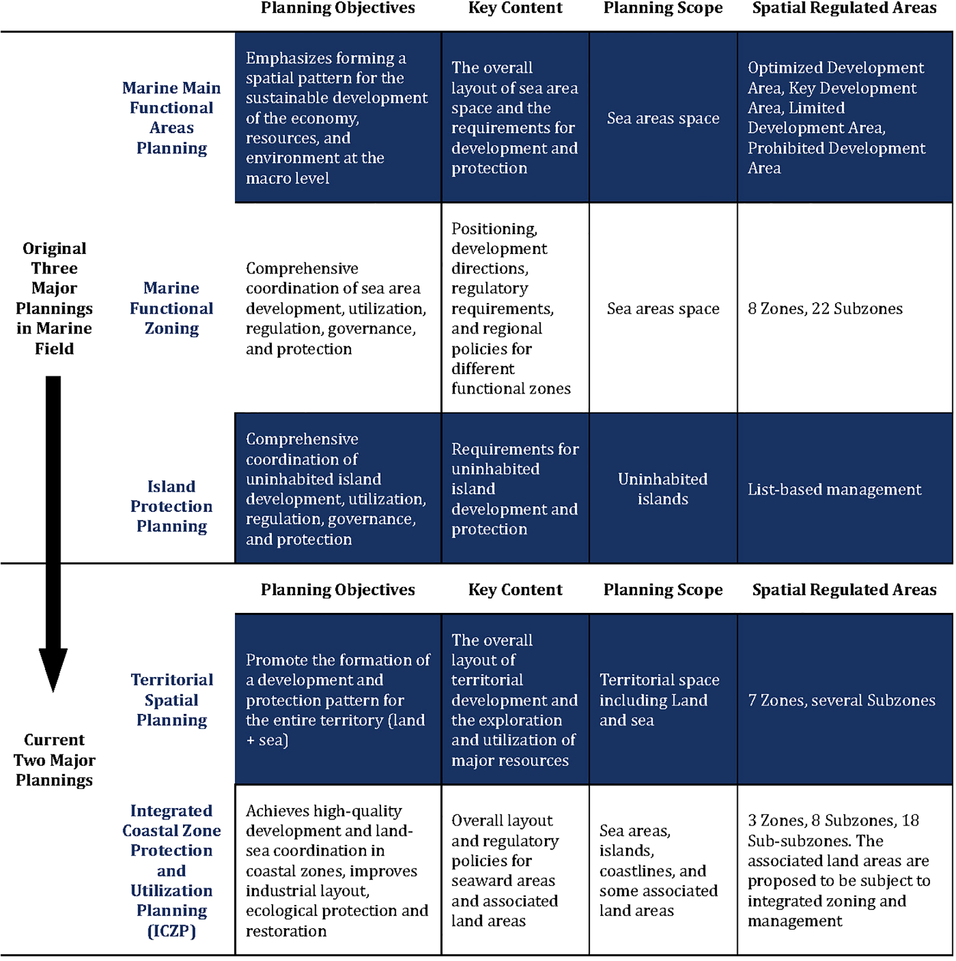
In 2019, the Opinions of the CPC Central Committee and the State Council on Establishing a Territorial Spatial Planning System and Supervising its Implementation (CPC Central Committee and State Council, 2019) proposed to merge various types of national plans, including MFZ and land use planning, into a unified territorial spatial planning to integrate the different plans into a single master plan, plan the territorial spatial development and protection pattern as a whole, establish a territorial spatial planning system consisting of five levels and three types (Table 2), formulate special planning for the coastal zone, strengthen the coastal zone management, and incorporate the core idea of coastline management into coastal zone management.
Table 2
| Territorial Spatial Planning System | Five Levels | National level |
| Provincial level | ||
| Municipal level | ||
| County level | ||
| Township level | ||
| Three Types | Overall planning | |
| Detailed planning | ||
| Special planning |
Territorial spatial planning system.
Coastal zone planning is an important approach and tool for carrying out integrated coastal zone management and for realizing sea-land integration in China, thus achieving overall planning for coastal zone space protection, developing a development and use pattern, scientifically arranging the ecological space, production space, and living space in coastal zones, implementing coordinated land and marine development, and integrating several individual plans into a single master plan. Coastal zone planning, based on the integrity of land and marine ecosystems and the relevance of development and use, needs to identify the integrated land-sea protection and use space. It achieves overall planning for protection, restoration, rehabilitation of the ecological environment, development, and use activities in certain areas, and it provides clear development guidelines and coordinated regulation requirements (Ministry of Natural Resources, PRC, 2021).
By studying China’s practice of transitioning from coastline management to coastal zone management, this paper reveals the laws and features by which China will gradually transition from a sea-land binary management system to integrated management. Based on specific practices at the national and local levels and from the perspectives of policies and regulations, planning and zoning, targets and indicators, and management measures, we investigate how coastline management can ensure the implementation of MFZ and how coastline management can gradually promote formulation of coastal zone planning based on coordinated land and marine development and transition to integrated sea-land management. Taking Tangshan, Hebei, China as an example, we show that the local authorities have formulated coastline management policies to guarantee the implementation of MFZ from the perspectives of hierarchical and categorized coastline protection and use, objectives setting, and zoning and management measures. In addition, they have made up for the deficiency of MFZ in coordinated land and marine development. On this basis, under the guidance of integrated sea-land space management in China, the city is formulating planning for coastal zones and is gradually transitioning to integrated sea-land management.
2 Coastline management promotes the sea-land integration progress
China’s coastlines are divided into three categories, namely, natural, artificial, and other coastlines (Ministry of Natural Resources, PRC, 2019). Natural coastlines include bedrock, sandy, muddy, and biological coastlines. Artificial coastlines are those formed by three types of engineering, namely, land reclamation, sea reclamation, and structures. Other coastlines include ecological restoration and estuary coastlines. Notably, ecological restoration coastlines refer to coastlines with natural coastal morphological characteristics and ecological functions after restoration and rehabilitation.
China’s coastline management has developed a guarantee system from top to bottom, including policies and regulations, allocation to authorities, planning and zoning, and standards and norms (Tables 3, 4). Coastline surveys and statistics are the basic work of coastline management. A revised coastline survey is the key to timely identification of coastline changes and adjusting management strategies. Therefore, planning to implement categorized coastline protection and use enhances the high efficiency and scientificity of coastline management. National coastline dynamic monitoring and local on-site inspection for coastline protection and use guarantee the effective implementation of coastline management policies (Figure 1).
Table 3
| Levels | Policies and Regulations | Planning & Zoning | Authorities | Standards |
|---|---|---|---|---|
| National level | Marine Environment Protection Law of the People’s Republic of China; Law of the People’s Republic of China on Administration of the Use of Sea Areas; Opinions of the CPC Central Committee and the State Council on Accelerating Ecological Civilization Construction; General Plan for the Reform of the Ecological Civilization System; Regulations for Coastline Protection and Use, etc. | National Marine Functional Zoning, National Marine Main Functional Areas Planning | State Council, State Oceanic Administration, etc. | Technical Regulations on Coastline Resource Survey, Technical Regulations on National Coastline Revision Survey, etc. |
| Provincial level | Notice of the General Office of the Zhejiang Provincial People’s Government on Strengthening Coordinated Coastline Management; Implementation Measures for Natural Coastline Control of the Guangxi Oceanic Administration, etc. | Provincial Marine Functional Zoning, Provincial Coastline Protection and Utilization Planning (e.g., Zhejiang) | Provincial people’s governments and provincial marine administrative departments | Technical Specifications for Coastline Survey of Shandong Province, Technical Specifications for Coastline Survey and Statistics and Technical Regulations on Coastline Remediation and Restoration Assessment of Zhejiang Province, etc. |
| Municipal level | Qinhuangdao Coastline Protection Regulations, Dalian Coastline Protection and Restoration Implementation Plan, Opinions of the Nantong Municipal Government on Further Improving Riverband and Coastline Use Management, etc. | Municipal Marine Functional Zoning, Municipal Coastline Protection and Utilization Planning (e.g., Tangshan) | Municipal people’s governments and municipal marine administrative departments |
Coastline management system.
Table 4
| Levels | Policy documents | Specific Contents |
|---|---|---|
| National | National Marine Functional Zoning (2011–2020) | Proposes to strictly control development and use activities occupying coastlines; by 2020, reserve no less than 35% of the natural mainland coastlines and complete the improvement and restoration of a coastline length of no less than 2,000 km (State Council, PRC, 2012) |
| Opinions of the CPC Central Committee and the State Council on Accelerating Ecological Civilization Construction | Reiterates the objective that the reservation rate of the natural mainland coastline shall be no less than 35%, proposes to strictly implement a total sea reclamation control system and a natural coastline control system, and establishes a regionally linked marine ecological environment protection and restoration mechanism based on coordinated land and marine development (CPC Central Committee and State Council, 2015a) | |
| General Plan for the Reform of the Ecological Civilization System | Proposes to implement a total sea reclamation control system, carry out obligatory target management for sea reclamation area, and establish a system to control the reservation rate of the natural mainland coastline (CPC Central Committee and State Council, 2015b) | |
| Regulations for Coastline Protection and Utilization | Puts forward definite requirements for categorized coastline protection, economical use, remediation and restoration, and supervision and management, etc (Ministry of Natural Resources, PRC, 2017) | |
| Local | Notice of the General Office of the Zhejiang Provincial People’s Government on Strengthening Coordinated Coastline Management | Puts forward requirements to establish a sound coordinated coastline operation mechanism, enhance coastline protection, use, planning, and management, and strengthen dynamic coastline resource supervision, etc (General Office of the People’s Government of Zhejiang Province, 2015) |
| Opinions of the Zhejiang Provincial Bureau of Ocean and Fishery on Strengthening the Management of Coastline Protection and Use | Puts forward requirements to strictly control coastline use, practically enhance natural coastline protection, comprehensively promote coastline remediation and restoration, and strengthen coastline supervision and inspection, etc (Department of Natural Resources of Zhejiang Province, 2018) | |
| Zhejiang Coastline Protection and Utilization Planning (2016–2020) | With the dual indicators of protection levels and sea reclamation control, it defines the coastline protection requirements, regulates the development extents and use modes, and formulates control requirements for different types of coastline sections to improve the ability to control coastline use (Department of Natural Resources of Zhejiang Province, 2020). | |
| Implementation Measures for Coastline Occupation and Replenishment in Guangdong (Trial) | Proposes to establish a coastline occupation and replenishment system to achieve a balance between coastline occupation and restoration compensation, standardizes the implementation process of coastline occupation and replenishment, strengthens the supervision of shoreline remediation and restoration, and clarifies the responsibilities of coastline occupation and replenishment (Department of Natural Resources of Guangdong Province, 2021) | |
| Implementation Measures for Natural Coastline Control of the Guangxi Oceanic Administration (Trial) | Formulates regulations for categorized mainland coastline protection, use, remediation and restoration, demonstration and review of projects occupying natural coastlines, coastline surveys, surveillance monitoring, shoreline information reporting, and supervision and inspection, etc (Oceanic Administration of Guangxi Zhuang Autonomous Region, 2016) | |
| Jiangsu’s “Fourteenth Five-Year Plan” for the Protection, Utilization, and Planning of Natural Resources | Proposes to strengthen coastline use control and carry out categorized coastline control as per the requirements of strict protection, limited development, and optimized use (Department of Natural Resources of Jiangsu Province, 2021) | |
| Hebei Coastline Protection and Utilization Planning (2013–2020) | Proposes to carry out categorized coastline protection; puts forward the management requirements for coastline protection and use at all levels; and defines the coastline function types regarding the function use and development direction of coastlines (Ministry of Natural Resources, PRC, 2013) | |
| Qinhuangdao Coastline Protection Regulations | Proposes to implement a construction retreat line system and a categorized protection system for coastline protection; defines the requirements for organizational leadership, coordinated planning, supervision, and management of coastline protection; regulates coastline remediation and restoration, as well as pollution and disaster prevention and control; presents relevant regulations on the water quality criteria for upstream rivers that empty into the sea (The People’s Government of Qinhuangdao Municipality, 2021) | |
| Dalian Coastline Protection and Restoration Implementation Plan | Presents the requirements to carry out categorized coastline management, strengthen natural coastline protection, establish an accountability system for coastline remediation and restoration, conduct coastline monitoring and evaluation, and strictly implement supervision of coastline use, etc (The People’s Government of Dalian Municipality, 2021) | |
| Opinions on the implementation of the system of paid use of the Shantou harbour coastline | Stipulates the scope, rates, length approval, payment procedure, and use period, etc. in view of the charges in port coastline use (Department of Natural Resources of Guangdong Province, 2019) | |
| Opinions of the Nantong Municipal Government on Further Improving Riverband and Coastline Use Management | Categorizes coastline resources, defines the access criteria for coastline-related projects, and puts forward the requirements for the management, use, and approval, etc. of coastline resource development (Department of Natural Resources of Nantong Municipality, 2021) | |
| Interim Measures for the Management of Coastal Zone Protection and Development in Huludao | Stipulates the management, supervision, and planning, etc. of shoreline protection and use (The People’s Government of Huludao Municipality, 2015) | |
| Tianjin Blue Bay Remediation and Restoration Planning (Coastline Protection and Utilization Planning) (2019–2035) | Proposes the objectives for coastline remediation and restoration and natural coastline reservation; puts forward relevant work plans, taking tourist resources into full consideration, and builds a sea-enjoyable leisure and entertainment coastline landscape and coastline eco-parks in harmony between humanity and nature (Department of Natural Resources of Tianjin Province, 2019) | |
| The 14th Five-Year Plan for the Use and Protection of Natural Resources in Shanghai | Proposes to configure coastline resources in an optimized manner and implement a categorized coastline protection system and states that the reservation rate of the natural mainland coastline shall be no less than 12% (Department of Natural Resources of Shanghai Province, 2021) |
Policy documents related to coastline management.
Figure 1
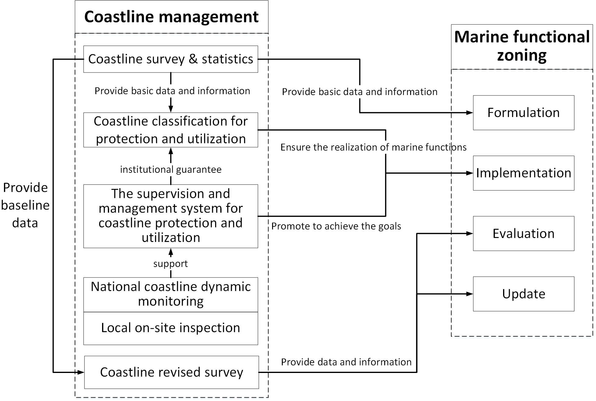
Schematic diagram of the guarantee effect of coastline management on marine functional zoning (MFZ).
China’s marine economy is developing rapidly, with a relatively large proportion of coastline occupied, causing varying degrees of damage to natural coastline. To coordinate the relationship between marine economic growth and natural ecological protection, it is necessary to optimize the development and utilization of coastline based on existing development activities, and implement a strict protection system for coastline with important ecological value.
China’s coastline management adopts a classified regulation approach, dividing the coastline into fishery coastline, industry coastline, transportation coastline, tourism and entertainment coastline, land reclamation coastline, special coastline, other use coastline and unused coastline. When determining the coastline use types, the marine use categories should be given priority. By implementing classified management of the coastline and formulating clear policy orientations, the development and protection activities in coastal areas can be guided. Different types of coastlines have different resource endowments and development potentials. Through classification, different protection and development and utilization requirements are formulated for them, the priorities of protection and utilization are determined, conflicts among stakeholders could be reduced, and a balance could be found between economic development and ecological protection. Meanwhile, classified supervision provides basic data for scientific planning and decision-making. Through detailed classification and assessment of different types of coastlines, more precise policies and management measures could be formulated, which also provides support for long-term planning and adaptive management.
2.1 Coastline management guarantee of the formulation and implementation of MFZ
2.1.1 Coastline surveys provide data and information
Coastline surveys provide baseline data and basic information for the formulation of MFZ (Figure 1). The location, length, type, status quo of development and use, and other basic information can be obtained through surveys and can be used to clarify the scope and boundaries of MFZ and can improve the scientificity of setting coastline objectives, including the reservation rate of the natural mainland coastline and the length of the restored coastline.
Based on the natural attribute of coastline changes and the social attributes of coastline management, China has organized revised coastline surveys from the top downward to ascertain coastline changes and evaluate the achievement of regulation objectives, including the reservation rate of the natural mainland coastline and the length of the restored coastline, thus providing a reference and basis for evaluating the implementation effect of MFZ and adaptive updates (Figure 1).
2.1.2 Division of coastline use types reflect the requirements of marine functions
The status quo of coastline development and use is comprehensively determined based on the status quo of coastal zones on the seaward side and landward side, which further defines the coastline use types. From a physical geography perspective, as a two-dimensional line, the coastline use type should be consistent with the surrounding space. From an ecological protection perspective, the coastline use type should be based on the ecosystem protection requirements, development demands, and the status quo of the development and use of intertidal areas (i.e., coastal zones between the mean highest tide level and the mean lowest tide level). From an administrative perspective, the responsibility of coastline management is undertaken by marine administrative departments. Therefore, due to the convenience and unity of management, the coastline use types express the status quo of protection and development on the seaward side, which generally corresponds to the eight zones of MFZ (Table 5), and reflect the requirements of marine functions.
Table 5
| Coastline use types | Definitions of coastline use types | Marine functional zones |
|---|---|---|
| Fishery coastline | Refers to coastlines occupied by fishery production activities such as fishing harbors, fishery infrastructure, and sea farming. | Agriculture and fishery zone |
| Industry coastline | Refers to coastlines occupied for industrial production activities | Industry and urban use zone, minerals and energy zone |
| Transportation coastline | Refers to coastlines occupied by transportation activities | Port and navigation zone |
| Tourism and entertainment coastline | Refers to coastlines occupied by coastal tourism development activities | Tourism and entertainment zone |
| Land reclamation coastline | Refers to coastlines occupied by urban construction such as land reclamation, roads, and squares | Industry and urban use zone |
| Special coastline | Refers to coastlines occupied for scientific research, teaching, and military use of sea, etc. | Special purpose zone |
| Other use coastline | Refers to coastlines used for purposes other than those mentioned above | Special purpose zone, marine protection zone |
| Unused coastline | Refers to coastlines not used yet | Marine protection zone, reservation zone |
Correspondence between coastline use types and MFZ.
2.1.3 Coastline protection promotes the achievement of MFZ objectives
The objective of reserving no less than 35% of the natural mainland coastline set by the national MFZ is decomposed progressively into MFZ at the provincial, municipal, and county levels and is further defined in the Regulations for Coastline Protection and Utilization (Ministry of Natural Resources, PRC, 2017). The annual plans for natural coastline protection and regulation should be formulated at the provincial level and should then be decomposed and implemented. This includes local practices carried out to promote the achievement of MFZ objectives.
The work conducted to achieve coastline protection takes the reservation rate of the natural mainland coastline as the core objective, defines the authorities responsible for coastline management, and releases relevant policy documents. The State Oceanic Administration is responsible for the guidance, coordination, supervision, and management of coastline protection and use. The coastal provincial people’s governments are responsible for supervising and managing coastline protection and use in their administrative regions. The work conducted to achieve natural coastline protection is included in the government performance examination on coastal municipal people’s governments, thus strengthening the significance of coastline protection in view of local practices and guaranteeing the achievement of this MFZ objective (reservation rate of natural mainland coastline) decomposed to that region. The State Oceanic Administration organizes the supervision of the management of coastline protection and use by costal people’s governments at all levels. For sea reclamation projects that fail to meet the regulated objectives and requirements of the reservation rate of natural mainland coastline, sea use should not be approved.
2.2 Coastline management promotes the extension of MFZ to the land
Coastline management practices take both sea and land spaces into consideration and are an initial practice in management based on coordinated land and marine development under the sea-land binary management system in China. Coastline management also promotes the extension of MFZ to land in the process of guaranteeing the implementation of MFZ, laying a foundation for coastal zone planning formulation and thus playing a bridging role during the transition from MFZ to coastal zone planning (Figure 2). The institutional framework formed through the transition from MFZ to coastal zone management are shown in Figure 3.
Figure 2
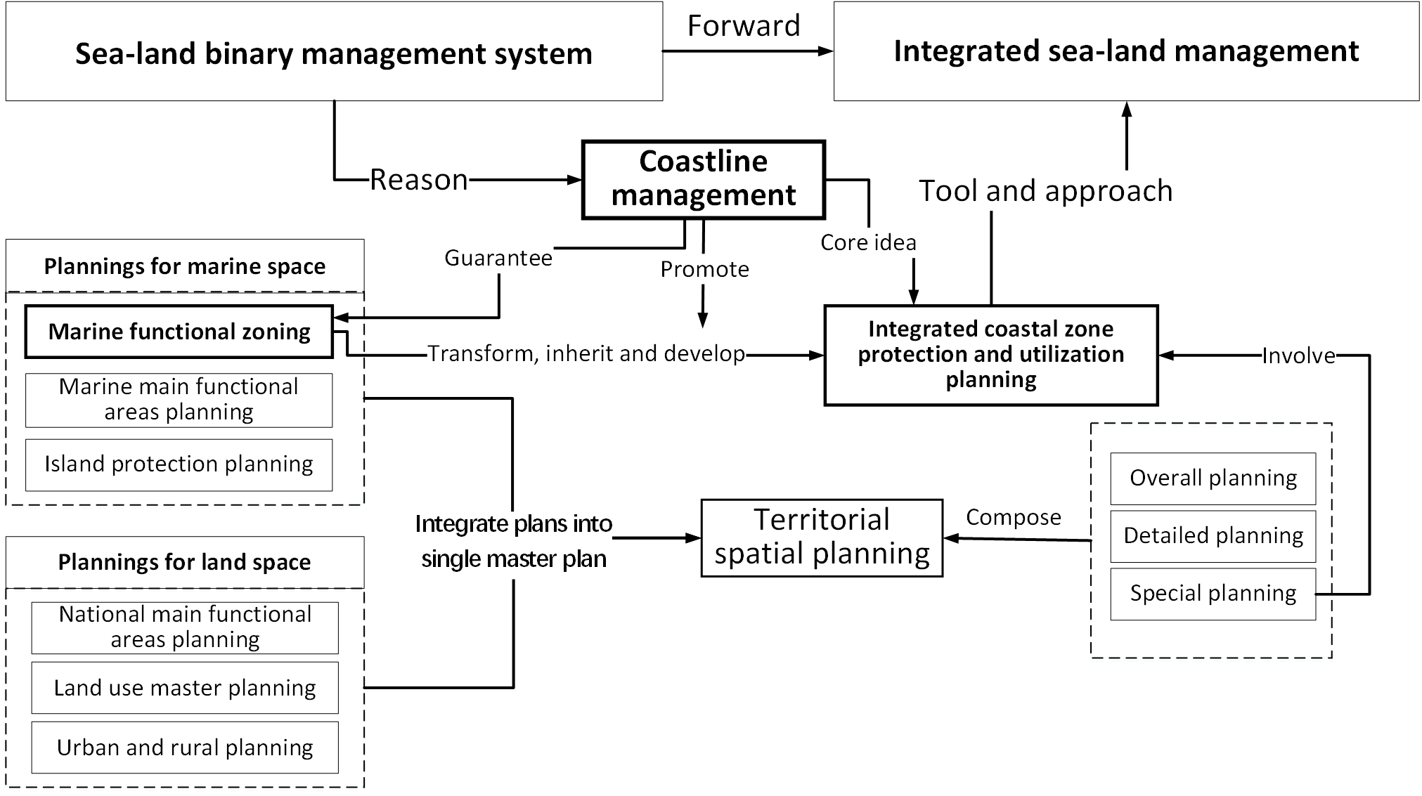
Schematic diagram showing how coastline management promotes the sea-land integration process.
Figure 3
The institutional framework toward coastal zone management (Teng et al., 2021; Ministry of Natural Resources, PRC, 2020; Ministry of Natural Resources, PRC, 2021).
2.3 Transition from MFZ to coastal zone planning
Based on China’s new territorial spatial planning system, special planning should be formulated for coastal zones, which is named the Integrated Coastal Zone Protection and Utilization Planning. The Integrated Coastal Zone Protection and Utilization Planning actually includes all of the responsibilities of the original spatial planning in the marine field which is shown in Figure 3 (including MFZ, marine main functional areas planning, and island protection planning). It tries to retain and incorporate the beneficial practices of the original spatial planning in the marine field, combines with the latest requirements of territorial spatial planning and marine space management, integrates the core concepts of coastline management. It is the inheritance and development of the marine functional zoning, and it provides necessary guidance and constraints for part of the associated land space (Figure 2).
The Integrated Coastal Zone Protection and Utilization Planning inherits the natural coastline protection objectives of MFZ, puts forward coastline management requirements, and gradually develops into a key tool for refined coastline regulation. According to the condition of the natural resources and the extent of development, coastlines are divided into three categories, namely, strict protection, limited development, and optimized use. Coastlines are divided into segments consisting of a combination of physical geographical units, and then, they are protected and used in a categorized and segmented manner. The implementation of the coastal construction retreat line system is recommended, with coastlines as the baseline, based on full consideration of the natural attribute of coastlines, the status quo of the development and use on both sides, and the planned functions to determine the coastal construction retreat distance in a categorized manner and to formulate an access list for construction activities within the retreat areas and the regulation requirements.
The Integrated Coastal Zone Protection and Utilization Planning inherits the core idea of zoning from MFZ. The zoning is based on the industrial sea use requirements, defines the space on the seaward side of the coastline with the functions of development and utilization as the marine development zone, and sets up six subzones and 18 sub-subzones based on the purposes and functions of the marine space (Ministry of Natural Resources, PRC, 2021; Zhao et al., 2022) (Table 6).
Table 6
| Objectives | Code | Zones | Code | Subzones | Code | Sub-subzones |
|---|---|---|---|---|---|---|
| Protection and reservation | 1 | Ecological protection zone | 1-1 | Ecological protection zone | — | — |
| 2 | Ecological control zone | 2-1 | Ecological control zone | — | — | |
| Development and utilization | 3 | Marine development zone | 3-1 | Marine fishery zone | 3-1-1 | Fishery infrastructure zone |
| 3-1-2 | Nursery and mariculture zone | |||||
| 3-1-3 | Capture zone | |||||
| 3-2 | Marine transportation zone | 3-2-1 | Port zone | |||
| 3-2-2 | Navigation zone | |||||
| 3-2-3 | Road, bridge, and tunnel zone | |||||
| 3-3 | Marine industry mining and communication zone | 3-3-1 | Industrial zone | |||
| 3-3-2 | Salt pan zone | |||||
| 3-3-3 | Solid mineral zone | |||||
| 3-3-4 | Oil and gas zone | |||||
| 3-3-5 | Renewable energy zone | |||||
| 3-3-6 | Submarine cable and pipeline zone | |||||
| 3-4 | Marine tourism and recreation zone | 3-4-1 | Tourism zone | |||
| 3-4-2 | Recreation zone | |||||
| 3-5 | Marine special purpose zone | 3-5-1 | Military zone | |||
| 3-5-2 | Culture and heritage preservation zone | |||||
| 3-5-3 | Other special purpose zones | |||||
| 3-6 | Marine reservation zone | 3-6-1 | Marine reservation zone |
Zones of the integrated coastal zone protection and utilization planning.
2.4 China coastline management need improvement
The limitation of separate sea-land planning and management is mainly reflected in the following three aspects. First, the ecosystem is fragmented, which is not conducive to protection. Simply taking the coastline as the boundary for planning and management usually fragments certain natural geomorphic units in coastal zones, affects the integrity of their ecological functions, and/or causes artificial fragmentation of coastal zone areas with research and conservation values, such as mangroves and estuary ecosystems (Hou et al., 2022). Second, the purposes of the land and sea are not well coordinated, which is not conducive to development. Land and marine spatial plans are formulated by land management authorities and marine management authorities. They have different spatial delimitation standards and development and protection strategies. Therefore, unmatched spatial purpose planning may exist in neighbouring land and marine spaces. For example, an industrial zone is next to a protection or tourism zone, with no buffer zone in between. Third, the linkage of plannings is difficult, which is not conducive to management. Regarding planning scales, due to the differences in the physical geographic attributes and social development attributes between land and marine spaces, land spatial planning is usually smaller in scale and more detailed. Regarding spatial purposes, the differences between land and marine industries lead to the fact that land and marine spatial purposes cannot be categorized and zoned in complete conformity. Regarding institutional systems, independent law systems, institutional systems, and planning formulation and approval processes are available for sea and land, which become a barrier for integrating sea and land planning.
The promulgation and implementation of China’s coastline protection and management policies have made outstanding contributions in maintaining the integrity and diversity of marine ecosystems, building a national marine ecological security barrier, promoting the green development of marine economy, and enhancing the well-being of people in coastal areas. However, several problems that need to be solved urgently have still been exposed in management practice (Zhang et al., 2019). Through empirical analysis and systematic attribution of typical cases, the problems and key directions for optimizing China’s coastline management have been sorted out. First, there is a lack of scientificity. In actual situations, coastlines usually exhibit significant dynamic evolution characteristics due to the superimposed influence of human factors, natural factors, etc (Liu and Li, 2024; Wang et al., 2024). However, the current coastline management system, which focuses on administrative management attributes and adopts a static and fixed boundary delimitation method, resulting in a significant deviation between the legal coastline location and the actual geographical boundary. The second issue is that it has excessive rigidity but insufficient elasticity. According to the coastline management policy, the target of reservation rate of the natural mainland coastline has been allocated to each province, city and county for specific implementation. However, in the actual management process, due to factors such as the differences in regional coastal zone resource endowments and the differentiation of economic development strategies, the constraints of a single rigid indicator are difficult to meet the actual needs of local areas. There is an urgent need for a dynamic management mechanism that takes into account both the rigidity of ecological protection and the flexibility of local development. It is suggested to explore the establishment of a cross-regional compensation and replacement system for the indicator of reservation rate of the natural mainland coastline, and optimize the spatial allocation for the protection and utilization of coastline resources.
2.5 Coastal zone planning is the tool and approach for sea-land integration
As a transition zone between the sea and land, the coastal zone is an important area for breaking through the limitations of separate sea and land management systems and achieving coordinated land and marine development. In the early 1950s, western countries began to study coastal zones and basically formulated a mature management system. The United States released the milestone Coastal Zone Management Act in 1972, which was the first in the world to present integrated coastal zone management in the form of legislation (Li et al., 2021b). Since then, many coastal countries have carried out integrated management in coastal zone areas.
The UK attaches importance to coordinated marine and land planning, with specific requirements for institutional design and formulation practices. Regarding development, it focuses on the leading role of marine development and utilization in socioeconomic development in coastal zones. In land planning, it safeguards the construction of supporting facilities for marine development activities. Regarding protection, it focuses on protecting the ecosystem and landscape in sea-land transition zones, prevents the sea from being disturbed by land development and utilization activities, and prevents and controls land-sourced pollution and marine disasters (Li et al., 2021a).
China’s Integrated Coastal Zone Protection and Utilization Planning focuses on land-sea interaction areas and is a key tool and approach for realizing sea-land integration (Figure 2). The Integrated Coastal Zone Protection and Utilization Planning is based on two types of objectives, namely, protection and utilization, takes coordinated land and marine development and harmony between humans and the sea as the main principles, identifies the spaces for sea-land integration protection and utilization, and puts forward coordinated regulation requirements. Regarding protection, in order to guarantee the health and integrity of ecosystems, sea-land integration protection spaces are delimited based on the boundaries of natural ecosystems that are continuously disturbed in both the sea and land so as to establish unified ecological protection and control requirements. Moreover, in both neighbouring sea and land areas, development activities that have a significant impact on the marine ecology are prohibited, such as industries with high energy consumption, high pollution, and low technology. Regarding utilization, based on industries that cross sea and land, sea-land integration utilization spaces are delimited according to the spatial boundary of industrial development, such as fisheries, ports, sea-side industries, and coastal tourism. The spatial layout of industries and the construction of infrastructure are coordinated to achieve coordination of sea-land functions and complementarity resources (CPC Central Committee and State Council, 2015b).
In addition to the regulation of sea-land integration protection and utilization spaces, the layout optimization and adjustment of the land spaces also considers the development and protection direction, the resources and environmental carrying capacity, the risks posed by marine disasters, and other factors in associated sea areas (CPC Central Committee and State Council, 2015b).
2.6 Case study
Located in the western part of the Bohai Sea, Tangshan, China, has a total managed coastline length of 229.27 km. There are two major water systems along the coastline that enter the sea, the Luan River and the Hai River. A wide range of mudflats and numerous tidal creeks are present, which could be used for land reclamation and port construction. The chain of outer sand islands has a protective effect on the lagoons and mainland coastline, which is an important basis for achieving overall stability of the coastline (The People’s Government of Tangshan Municipality, 2016). The degree of coastline development and utilization is relatively high, the intensity and scope of the development are expanding based on port and port-centred industrial development, and development hotspots are emerging. Therefore, scientifically dividing and rationally determining coastline functions are of great significance for achieving the objectives of MFZ and promoting the formation of a marine spatial development pattern that is coordinated in terms of the population, economy, and environment. The Tangshan Coastline Protection and Utilization Planning (2016–2020) implements MFZ and promotes the formulation of coastal zone planning.
The coastline planning objectives set reflect the Tangshan MFZ requirements. The qualitative objectives set by the Tangshan Coastline Protection and Utilization Planning (2016–2020) reflect the MFZ requirements for the construction of sea use demands for economic development, the basic sea use demands for fishery production, and the protection sea use demands of ecosystems. The four quantitative objectives separately set the length of ports and industrial coastlines, the proportion of ecological and living coastlines, the length of natural coastlines, and the length of restored coastlines (The People’s Government of Tangshan Municipality, 2016). These four objectives implement the National MFZ (2011–2020) (Ministry of Natural Resources, PRC, 2021) and link with Tangshan MFZ (2013–2020) (The People’s Government of Tangshan Municipality, 2013). They conform to the guiding ideology and basic principles of developing the marine economy, guarantee sea use for production, living, and ecology, optimize the spatial layout of marine development as proposed in MFZ, and reflect the quantitative requirements of MFZ for the reservation rate of natural mainland coastlines and the length of restored coastlines.
The function division of coastlines guarantees the utilization functions of the Tangshan sea areas. Based on the function division of sea areas in MFZ, the status quo of coastal development and use, and the key sea use requirements, coastlines in Tangshan are divided into three types with different functions, namely, production coastline, living coastline, and ecology coastline, which generally correspond to the positions of the development and protection functions in MFZ and reflect the development and protection requirements of MFZ. Notably, production coastlines refer to those used for coastal agricultural, ports, and industrial production. Their neighbouring sea areas are usually agriculture and fishery, industry and urban use, minerals and energy, and port and navigation zones in MFZ. Living coastlines refer to those used for constructing coastal living space. Their neighbouring sea areas are usually industry and urban use zone and tourism and entertainment zone in MFZ. Ecology coastlines refer to those used for coastline protection, coastal zone restoration, marine ecological environment reservation, and maintenance. Their neighbouring sea areas are usually marine protection zone and reservation zone in MFZ. Among all of the functional coastlines, ecology coastlines most directly reflect the reservation rate of natural mainland coastlines in MFZ (The People’s Government of Tangshan Municipality, 2016).
Hierarchical regulation of coastline protection guarantees the achievement of the objectives of the Tangshan MFZ. By dividing the basic functions of coastlines, the coastlines in Tangshan are divided into four levels for development and protection, namely, the key development coastline segment, optimized development coastline segment, limited development coastline segment, and prohibited development coastline segment (The People’s Government of Tangshan Municipality, 2016). Notably, for optimized development coastline segments, it is required that we guide industries to develop towards land in both scope and depth, use offshore sea spaces in an economic and intensive manner, reserve coastal and offshore sea spaces for future development, and guarantee the achievement of the objectives of MFZ, that is, to reserve space resources in sea areas and leave certain offshore sea areas for future development. Limited development coastline segments mainly include fishery coastlines. It is required that we guarantee sea use for fisheries, carry out coastline restoration, and strengthen pollution governance, thus helping to achieve the objective of MFZ, that is, to generally maintain stable sea use for fisheries and restore coastlines. Prohibited development coastline segments mainly aim to protect typical marine ecosystems, including marine protection zone, key estuaries, and wetlands. These segments play an important role in achieving the objectives of MFZ, including the reservation rate of natural mainland coastlines, the area of the marine protection zone, and the length of restored coastlines.
Coastline management promotes the formulation of Tangshan coastal zone planning. The scope of the Tangshan Coastline Protection and Utilization Planning (2016–2020) not only includes coastlines but also covers offshore sea areas that affect coastline development and utilization activities. In academic discussions, a unified definition of the coastal zone has not yet been attained. In general, coastal zones refer to areas formed when coastlines extend towards both the sea and land sides for a certain distance (Wen and Liu, 2019). Therefore, the extension of Tangshan’s coastline planning to the sea actually covers the coastal zone space on the sea side, which enabled the coordinated management of the land-sea interaction space in coastline management. The main reason that it does not extend towards the land is that the coastline management authority belongs to marine administrative departments. The merging of marine and land administrations in 2018 provided an opportunity to evolve coastline management to integrated coastal zone management. Inheriting the core ideas of MFZ and the Coastline Protection and Utilization Planning, Tangshan City is formulating an integrated coastal zone protection and utilization planning to promote the realization of integrated management of the sea-land interaction space.
In recent years, Tangshan City has carried out systematic practices around the protection and utilization of its coastline, making coordinated efforts in multiple dimensions including policy formulation, ecological protection, and monitoring and supervision, and has achieved remarkable results. In terms of policy formulation, the port planning and management system is improved, issued the “Regulations on Ports of Tangshan City” (The Standing Committee of the People's Congress of Tangshan City, Hebei Province, 2019), to strengthen the management of coastline resources, including enhancing the joint review of port coastline development projects, strengthening the management of sea and land areas in the port planning area, and regulating the allocation and utilization of port coastline resources. In terms of ecological protection and restoration, Tangshan City, relying on major ecological restoration projects, has formed a relatively mature technical system in the transformation of beaches, islands, bays and embankments. In the 2022 marine ecological protection and restoration project (The People's Government of Tangshan City, 2024), the total area of restoration and governance reached 10.05 square kilometers, including the ecological governance of 10 kilometers of shoreline along the seawall, the construction of 6 inshore ecological submerged reefs, and the establishment of 1 set of seagrass bed intelligent monitoring system. At the same time, Tangshan City continues to enhance its marine environmental monitoring capabilities, conducting surveillance on the water quality, sediment quality, and marine biological quality in inshore waters. It dynamically grasps the trends of ecological and environmental changes around the coastline, providing scientific data support for policy formulation and project implementation, and promoting the development of refined and intelligent coastline management.
In the Hebei Province region where Tangshan City is located, a total of 17.32 kilometers of coastline had been restored by the end of 2020. By 2023, the total length of restored coastline reached 48.073 kilometers. Nationally, China annually selects typical cases of marine ecological protection and restoration to set excellent demonstration examples, with more than half of these cases involving coastline protection and restoration (see Table 7).
Table 7
| Case name | Length of restored coastline | Key principle |
|---|---|---|
| Marine Ecological Protection and Restoration in Beidaihe, Qinhuangdao City, Hebei Province | 14.5km | Legislative guarantee, land-sea coordination, source pollution control, targeted measures for eroded sandy coastline, and construction of a biodiversity “ecological corridor” in the coastal zone. |
| Ecological Protection and Restoration of Sunshine Coastal Greenway in Rizhao City, Shandong Province | 6.8km | Following the principle of combining protection with development, restoring the coastline while constructing the Sunshine Coastal Greenway and developing cultural tourism industry. |
| Marine Ecological Protection and Restoration in Taizhou City (Yuhuan), Zhejiang Province | 14km | Mangrove saltmarsh wetland restoration, gravelly coastline restoration, and ecological improvement of artificial coastline. |
| Marine Ecological Protection and Restoration of Kongque Bay in Qinzhou City, Guangxi Province | 5.3km | Systematic restoration, innovative mangrove cultivation technology, wetland restoration, and improvement of mangrove habitats. |
| Ecological Protection and Restoration of Meishan Bay in Ningbo City, Zhejiang Province | 2.252km | Taking ecological value enhancement as the core, establishing a “1+N” comprehensive governance system including coastal beach regulation and ecological restoration. |
Part of national typical cases of marine ecological protection and restoration.
3 Discussion
Coastline management is a system that has gradually developed in China under the condition of long-standing separate land and sea space management and is the administrative boundary for carrying out land and marine management. In this context, corresponding policies and regulations, allocation to authorities, planning and zoning, and standards and norms have been developed to guarantee the coordination, supervision, and management of coastline protection and utilization.
In China, coastlines are an important means of production. Numerous sea use activities, including port construction, marine transportation, coastal tourism, and submarine pipelines, need to utilize coastline resources. For a long time, as a key management tool, coastline management has focused more on the functions of development and protection on the seaward side and represents the objectives of MFZ and guarantees the regulation requirements of MFZ by giving full consideration to the resource endowment, utilization status, and development requirements of the neighbouring land and marine spaces of the coastline. However, the limitations of independent land and marine spatial regulation are also relatively obvious in view of guaranteeing ecosystem continuity, economic development connectivity, and consistency in the implementation of plannings.
A coastline management system is established from the national level to the local level, defining both the use types and functions of coastlines. At the local level, characteristic coastline management measures suitable for local development are developed according to the local conditions. The coastline is the transition line and connection line linking sea and land management, so the division of the coastline functions determines the functions of most parts of the seaward side spaces and landward side spaces. This results in the most preliminary and original coordination between the sea and land, which involves not only the coordination of development and utilization but also environmental protection.
With the continuous improvement of China’s territorial spatial planning system and the constant development of the territorial spatial management mode, it has been increasingly realized that implementing coastal zone planning and management based only on coordinated land and marine development can achieve scientific protection and rational use of coastline resources. It is proposed to integrate plans into a single master plan, establish a Territorial Spatial Planning system covering entire land and marine spaces, carry out integrated coastal zone management based on coordinated land and marine development, and formulate special plans for coastal zones. As an important tool for coastal zone management, coastal zone planning continues to undertake the responsibility of MFZ in the protection and utilization of coastal zone areas, inherits and develops the coastline management ideas, and formulates measures and requirements to regulate coastline protection, development, utilization, and restoration so as to manage coastline resources in a refined manner. Coastal zone planning defines the indicator of the reservation rate of natural mainland coastlines, carries out categorized coastline protection and utilization according to the natural resource conditions and the development extent, carries out coastline rehabilitation and restoration according to the ecological damage caused to coastal zones, and develops indicators for coastline occupation and investment intensity to enhance the resource utilization ratio of coastal zones. It also expands public sea-enjoyable space, opens qualified coastlines to the public, determines the retreat distance to land, and delimits the coastal construction retreat line by taking coastlines as the benchmark.
The Tangshan Coastline Protection and Utilization Planning reflects the MFZ requirements from three perspectives, namely, an objective set, function division, and hierarchical regulation, thus guaranteeing that the functions of development and protection are achieved in the neighbouring marine space. It practices coastline management locally, implements national regulations for coastline protection and use, and fulfills the objectives for higher level MFZ. Moreover, the Tangshan Coastline Protection and Utilization Planning extends the line planning to zone space on the seaward side, which can also be regarded as the embryonic form of coastal zone planning, which is gradually being developed in the practice of coastline management. As China is gradually transitioning to integrated sea-land management, Tangshan is responding to the policy requirements. Tangshan has developed its Coastal Zone Protection and Utilization Planning based on the local resource conditions, status quo, and development requirements in order to promote the achievement of integrated coastal zone management based on coordinated land and marine development.
China has established a territorial spatial planning system, and it is formulating coastal zone planning from top to down. However, how to organically integrate land planning and marine planning and truly realize integrated sea-land management still requires continuous exploration and innovation in terms of the system, technology, and administration.
4 Conclusions
China’s transition from coastline management to coastal zone planning is an important practice for transitioning from sea-land binary management to integrated sea-land management. Coastline management is the basis for sea-land integration. It guarantees the formulation and implementation of MFZ, promotes the extension of MFZ to land areas, and serves as a bridge and link for the transition from MFZ to coastal zone planning. China’s national institutional reform and integration of individual plans into a single master plan provide an opportunity for transition of coastline management towards integrated sea-land management. Coastal zone planning is a tool and approach for integrated sea-land management. The idea of coastline management is preserved and developed in coastal zone planning. The refined coastline management requirements are incorporated and reflected in coastal zone planning. The experience of coastline management promotes the formulation of coastal zone planning, guarantees the achievement of coastal zone planning objectives, and facilitates the implementation of integrated sea-land management.
Coastline management ensures the implementation of MFZ at the beginning, in the middle, and at the end. Coastline surveys provide data and information for MFZ. Coastline use types reflect the sea space protection, development, and use requirements of MFZ. To the greatest extent, the coastline protection system at the national and local levels guarantees the achievement of the objectives of MFZ in terms of achieving the reservation rate of natural mainland coastlines. Revised coastline surveys provide data and references for evaluating the implementation of MFZ.
In the process of transitioning from MFZ to coastal zone planning, coastline management plays a connecting and linking role. As the demarcation line between sea and land, coastlines occupy an important position in the sea-land integration process. The core idea of coastline management is preserved in coastal zone planning so as to support integrated coastal zone management and provide safeguards for overall sea-land ecosystem protection, sea-land industrial connectivity, and integrated sea-land management.
Statements
Author contributions
QZ: Formal analysis, Software, Visualization, Data curation, Writing – original draft, Conceptualization, Writing – review & editing, Supervision, Methodology, Investigation. XT: Writing – review & editing, Conceptualization, Funding acquisition, Supervision, Resources, Project administration. XM: Writing – review & editing, Project administration. ZD: Writing – review & editing. PZ: Writing – review & editing. WK: Writing – review & editing.
Funding
The author(s) declare that financial support was received for the research and/or publication of this article. This research was funded by the Asian Cooperation Fund through ‘Building the Blue Partnership between China and ASEAN Countries’ (C3250DM02, C3240DM02, C3230DM02); ‘Research on Marine Related Detailed Planning and Use Regulation Technology’ (KF-2022-104) funded by the Key Laboratory of Marine Spatial Resources Management Technology of Ministry of Natural Resources, China; ‘Technical Path and Practice of International Cooperation on Marine Spatial Planning under Blue Partnership’ (C3220C004) funded by the China Oceanic Development Foundation; the project for ‘Belt and Road Construction’ named ‘Boosting the Blue Economic Development through Marine Spatial Planning’ including ‘Research on Cambodia Coastal Zone Protection and Utilization Planning Formulation (Y2200C002)’ and ‘Research on Antigua Coastal and Marine Spatial Planning Formulation’ (C3210C001).
Conflict of interest
The authors declare that the research was conducted in the absence of any commercial or financial relationships that could be construed as a potential conflict of interest.
Generative AI statement
The author(s) declare that no Generative AI was used in the creation of this manuscript.
Publisher’s note
All claims expressed in this article are solely those of the authors and do not necessarily represent those of their affiliated organizations, or those of the publisher, the editors and the reviewers. Any product that may be evaluated in this article, or claim that may be made by its manufacturer, is not guaranteed or endorsed by the publisher.
References
1
CPC Central Committee and State Council (2015a). Opinions of the CPC Central Committee and the State Council on accelerating ecological civilization construction. Available online at: https://www.gov.cn/guowuyuan/2015-05/05/content_2857363.htm (Accessed May 5, 2023).
2
CPC Central Committee and State Council (2015b). General plan for the reform of the ecological civilization system. Available online at: https://www.gov.cn/guowuyuan/2015-09/21/content_2936327.htm (Accessed May 5, 2023).
3
CPC Central Committee and State Council (2019). Several opinions of the CPC Central Committee and the State Council on the establishment of a national territorial spatial planning system and supervision of its implementation. Available online at: https://www.gov.cn/zhengce/2019-05/23/content_5394187.htm (Accessed April 9, 2023).
4
Department of Natural Resources of Guangdong Province (2019). Opinions on the implementation of the system of paid use of the Shantou harbor coastline. Available online at: http://www.gd.gov.cn/zwgk/wjk/zcfgk/content/post_2725117.html (Accessed June 5, 2023).
5
Department of Natural Resources of Guangdong Province (2021). Implementation Measures for Coastline Occupation and Replenishment in Guangdong (Trial). Available online at: http://www.gd.gov.cn/zwgk/gongbao/2021/20/content/post_3369495.html?jump=false (Accessed May 12, 2023).
6
Department of Natural Resources of Jiangsu Province (2021). Jiangsu "Fourteenth Five-Year Plan" for the Protection, Utilization and Planning of Natural Resources. Available online at: http://zrzy.Jiangsu.gov.cn/gtxxgk/nrglIndex.action?type=2&messageID=2c9082547b9e3a4e017ba094c2ef0040 (Accessed May 15, 2023).
7
Department of Natural Resources of Nantong Municipality (2021). Opinions of Nantong Municipal Government on Further Improving Riverband and Coastline Use Management. Available online at: https://www.nantong.gov.cn/ntsrmzf/szfwj/content/7616ba3e-0ec3-4c36-8f5e-22fa3a5620fd.html (Accessed May 12, 2023).
8
Department of Natural Resources of Shanghai Province (2021). The 14th Five-Year Plan for the Use and Protection of Natural Resources in Shanghai. Available online at: https://www.shanghai.gov.cn/202120bgtwj/20211022/51b70984663342a78ed285346f67cbb7.html (Accessed June 9, 2023).
9
Department of Natural Resources of Tianjin Province (2019). Tianjin "Blue Bay" Remediation and Restoration Planning (Coastline Protection and Utilization Planning) (2019-2035). Available online at: https://ghhzrzy.tj.gov.cn/zwgk_143/tzgg/202012/t20201206_4497183.html (Accessed June 7, 2023).
10
Department of Natural Resources of Zhejiang Province (2018). Opinions of Zhejiang Provincial Bureau of Ocean and Fishery on Strengthening the Management of Coastline Protection and Use. Available online at: https://zrzyt.zj.gov.cn/art/2018/7/22/art_1229098242_2322309.html (Accessed May 12, 2023).
11
Department of Natural Resources of Zhejiang Province (2020). Zhejiang Coastline Protection and Utilization Planning (2016-2020). Available online at: https://zrzyt.zj.gov.cn/art/2020/1/6/art_1660178_41455337.html (Accessed May 12, 2023).
12
General Office of the People’s Government of Zhejiang Province (2015). Notice of the General Office of Zhejiang Provincial People's Government on Strengthening Coordinated Coastline Management. Available online at: https://www.lawlawing.com/community/189872 (Accessed April 10, 2023).
13
Hou B. Yue W. Ma R. Wang T. Jia Y. (2022). Research on the challenges and realization path of sea-land coordination in territorial spatial planning. J. Natural Resources.37, 880–894. doi: 10.31497/zrzyxb.20220404
14
Li Y. Cao C. Wang P. Xiang H. Liu D. (2021a). Experience and reference of land-sea coordination in british marine space planning for China. Planners.37, 84–90.
15
Li Y. Hu Y. Guo Z. (2021b). China's coastal zone management conflicts and foreign experience. Dev. Res.5, 112–117. doi: 10.13483/j.cnki.kfyj.2021.05.015
16
Liu Y. Li T. (2024). Analysis of spatial and temporal changes of coastline morphology in Xiamen City under urbanization process. Remote Sens. Natural Resour.36, 267–274. doi: 10.6046/zrzyyg.2022386
17
Liu L. Wang H. Yue Q. (2020). Current situation and management countermeasures of coastline protection and utilization in China. Mar. Environ. Science.39, 723–731. doi: 10.13634/j.cnki.mes.2020.05.010
18
Ministry of Natural Resources, PRC (2013). Hebei has issued Coastline Protection and Utilization Planning. Available online at: https://www.mnr.gov.cn/dt/hy/201312/t20131202_2331673.html (Accessed May 12, 2023).
19
Ministry of Natural Resources, PRC (2017). Regulations for the Coastline Protection and Utilization. Available online at: http://gc.mnr.gov.cn/201806/t20180614_1795724.html (Accessed April 25, 2023).
20
Ministry of Natural Resources, PRC (2019). Regulation for national coastline revision survey. Available online at: https://www.fio.org.cn/news/tzgg-detail-8761.htm (Accessed May 2, 2023).
21
Ministry of Natural Resources, PRC (2020). Guidelines for municipal Territorial Spatial Planning (Trial). Available online at: https://www.cgs.gov.cn/tzgg/tzgg/202009/t20200925_655566.html (Accessed May 05, 2025).
22
Ministry of Natural Resources, PRC (2021). Guidelines for provincial Integrated Coastal Zone Protection and Utilization Planning (Trial). Available online at: http://gi.mnr.gov.cn/202109/t20210913_2680305.html (Accessed May 2, 2023).
23
Oceanic Administration of Guangxi Zhuang Autonomous Region (2016). Implementation Measures for Natural Coastline Control of Guangxi Oceanic Administration (Trial). Available online at: http://hyj.gxzf.gov.cn/zwgk_66846/tzgg/t4064609.shtml (Accessed May 12, 2023).
24
State Council, PRC (2012). National Marine Functional Zoning (2011-2020). Available online at: http://f.mnr.gov.cn/201806/t20180621_1830454.html (Accessed May 5, 2023).
25
Teng X. Zhao Q. Zhang P. Liu L. Dong Y. Hu H. et al . (2021). Implementing marine functional zoning in China. Mar. Policy132, 103484. doi: 10.1016/j.marpol.2019.02.055
26
The People's Government of Tangshan City (2024). The marine ecological protection and restoration project of Tangshan City has been successfully declared, being the only one in the province. Available online at: https://www.tangshan.gov.cn/zhuzhan/bsxw/20241021/1617538.html (Accessed May 06, 2025).
27
The People’s Government of Dalian Municipality (2021). Dalian Coastline Protection and Restoration Implementation Plan. Available online at: https://www.dl.gov.cn/art/2018/5/9/art_854_367864.html (Accessed June 1, 2023).
28
The People’s Government of Huludao Municipality (2015). Interim Measures for the Management of Coastal Zone Protection and Development in Huludao. Available online at: http://www.pkulaw.cn/fulltext_form.aspx?Db=lar&Gid=dfa23794dda9bfd2bedfea3157593ec2bdfb&isFromV6=1 (Accessed June 7, 2023).
29
The People’s Government of Qinhuangdao Municipality (2021). Qinhuangdao Coastline Protection Regulations. Available online at: http://mail.qhd.gov.cn/front_pcthi.do?uuid=174EB7C2231439ED7150EE65F79AD5DF (Accessed May 12, 2023).
30
The People’s Government of Tangshan Municipality (2013). Tangshan Marine Functional Zoning. Available online at: https://max.book118.com/html/2017/0625/118009928.shtm (Accessed May 8, 2023).
31
The People’s Government of Tangshan Municipality (2016). Tangshan Coastline Protection and Utilization Planning (2016-2020). Available online at: http://new.tangshan.gov.cn//u/cms/zhengwu/202112/11131335kibo.pdf (Accessed June 9, 2023).
32
The Standing Committee of the People's Congress of Tangshan City, Hebei Province (2019). Regulations on Ports of Tangshan City. Available online at: http://www.law-lib.com/law/law_view.asp?id=676250 (Accessed May 8, 2025).
33
Wang T. Zhang G. Zhang K. Fu Q. (2024). Dynamic changes of the Huizhou Coastline in nearly 50 years based on Landsat images and DSAS. Natl. Remote Sens. Bulletin.28, 689–703. doi: 10.11834/jrs.20231475
34
Wen C. Liu J. (2019). Review and prospect of coastal zone planning based on land and sea integration. Planners.35, 5–11.
35
Yang L. (2014). Study on Shoreline Management Based on Land/Sea Integration. Xiamen University, Xiamen.
36
Zhang Z. Zhou P. Huo S. (2019). Coastal line protection and utilization management based on land and sea coordination. Ocean Dev. Management.4, 3–8. doi: 10.20016/j.cnki.hykfygl.2019.04.001
37
Zhao Q. Teng X. Zhang P. Kang W. Meng X. Wang S. (2022). Research on the delimitation of marine spatial pattern based on the goal of “Carbon peaking and carbon neutrality. J. Mar. Sci. Eng.10, 1566. doi: 10.3390/jmse10101566
Summary
Keywords
coastline management, sea-land integration, marine functional zoning (MFZ), territorial spatial planning, coastal zone planning
Citation
Zhao Q, Teng X, Meng X, Du Z, Zhang P and Kang W (2025) China’s practice from coastline management towards sea-land integration. Front. Mar. Sci. 12:1603839. doi: 10.3389/fmars.2025.1603839
Received
01 April 2025
Accepted
09 June 2025
Published
09 July 2025
Volume
12 - 2025
Edited by
Dahai Liu, Renmin University of China, China
Reviewed by
Jing Yu, Ocean University of China, China
Shuo Wang, Ministry of Natural Resources, China
Updates
Copyright
© 2025 Zhao, Teng, Meng, Du, Zhang and Kang.
This is an open-access article distributed under the terms of the Creative Commons Attribution License (CC BY). The use, distribution or reproduction in other forums is permitted, provided the original author(s) and the copyright owner(s) are credited and that the original publication in this journal is cited, in accordance with accepted academic practice. No use, distribution or reproduction is permitted which does not comply with these terms.
*Correspondence: Xin Teng, notctengxin@163.com
Disclaimer
All claims expressed in this article are solely those of the authors and do not necessarily represent those of their affiliated organizations, or those of the publisher, the editors and the reviewers. Any product that may be evaluated in this article or claim that may be made by its manufacturer is not guaranteed or endorsed by the publisher.