Abstract
This study investigates the implications of spatial management strategies on fish populations and fisheries across EU waters, particularly focusing on establishing potential areas for fishing closures to protect nurseries, benthic communities, and biodiversity hotspots in the Northeast Atlantic and Mediterranean Sea. The research addresses the effectiveness of prohibiting certain fishing practices in the context of the EU Common Fisheries Policy (CFP). We investigate spatial- and effort-based fisheries management strategies based on spatial ecosystem modelling, which provides insights into species interactions and distribution shifts, and bioeconomic fisheries models which incorporate finely defined fishing fleets and economic dynamics. Our findings emphasize that redistributing fishing effort without reducing overall effort and catches may negate intended decreases in mortality rates of sensitive marine species or restoration of vulnerable marine habitats to the status targeted by the European marine legislation (EU Marine Strategy Framework Directive MSFD). We highlight the complex interplay of social, economic, ecological, and institutional factors influencing fishers’ decision-making in effort displacement. As the proportion of closed regions increases, potential effects on marine ecosystems can even be damaging in the short term to some sensitive species (such as the endangered, threatened and protected species ETP) and vulnerable habitats (with currently high relative benthic status RBS). This emphasizes the importance of the placement of closed areas and of combining area-based management with other fishery management measures. Findings from case studies in the North Sea, Mediterranean Sea, and Bay of Biscay indicate that prohibiting certain fishing practices in designated areas will likely induce short-term economic losses on specific fishing fleets. Where the prohibitions contribute to improved selectivity or productivity of the fish stocks, these losses may be regained in the long term. Finally, the long-term benefits for marine life that are expected through the spatial protection of vulnerable life stages and habitats will rely on the extent to which climate change affects ocean productivity and distribution of species and habitats.
Highlights
-
Prohibiting specific fishing techniques in all currently designated MPAs has only minor economic and ecological benefits for most fisheries and fish populations.
-
Prohibiting certain fishing practices in newly designated fit-for-purpose areas—intended to reduce the risk of incidental catches and benthic degradation—may significantly impact the fisheries economy and fish populations in the short term, but proves more effective for the long-term protection of species and habitats.
-
Effects of warming waters and changes in ocean ecology may outweigh the potential benefits of area closures as a management strategy, raising the need for climate adaptation strategies.
-
Area-based management should be used in combination with other technical measures to avoid negative impacts of effort displacement outside the managed area.
1 Introduction
The comprehensive Marine Action Plan Fisheries and Ocean package (European Commission, 2023) outlined several key actions to maintain sustainable levels of fish stocks and reduce the fishing impact on the seabed and on sensitive species (such as the endangered, threatened and protected species - ETP). These key actions include, among other things, the phasing out of mobile bottom fishing in MPAs by 2030. In 2024, this plan was accompanied by the Nature Restoration regulation (Regulation (EU) 2024/1991), which itself is a key element of the EU Biodiversity Strategy (EC, 2021). The Regulation sets quantified and time-bound restoration targets for habitats included in Annexe I of the Habitats Directive. Also, it establishes targets for protected species under the Habitats and Birds Directives and restoration targets for essential marine habitats covered by the directives and the Marine Strategy Framework Directive. Improving marine habitats listed in Annex II is aiming to ensure that they reach and stay in good condition. The Convention on Biological Diversity (CBD) recognizes that other spatial management measures, in addition to the fully closed MPAs, can help in the direction of preserving biodiversity and ecosystems. Fisheries restricted areas (FRAs), established by the General Fisheries Commission for the Mediterranean (GFCM) (Target 1 of the GFCM 2030 Strategy) have the twofold aim of improving fisheries productivity by regulating fishing activities in essential fish habitats (EFH, i.e. nurseries and spawning grounds of key commercial species), and protecting vulnerable marine ecosystems (VMEs) that could be negatively impacted by bottom-contact fishing gears. However, protecting at least 30% of the EU´s sea areas by 2030 through MPAs or even FRAs will impact ongoing fishing activities, affecting and redistributing fleet capacity and fishing efforts among operators.
Numerous marine areas have already been designated in EU waters to protect specific features of the marine ecosystems. However, half of the current MPAs have no fisheries restrictions, and 80% have a minimal to light level of protection (Feary et al., 2025; Hogg et al., 2024). A 2022 study shows that the large majority of EU MPAs (62.2%) and MPA coverage (85.7%) are under low protection regimes (lightly, minimally protected, or incompatible with biodiversity conservation) across all member states, regions, and MPA features (Aminian-Biquet et al., 2024). The recent vision of the European Commission (EC) is to move forward implementing management plans in the MPAs where there are none; for example, less than 40% of the marine Natura 2000, both SCIs (sites of community importance) and SACs (special areas of conservation) sites declared to have management plans (Hogg et al., 2024). One of the most critical elements of the EC Marine Action plan (COM (2023) 102 final) is to regulate the activity of mobile bottom-contacting fishing gears in EU waters, to reduce impacts on the seafloor. Reducing incidental catch by more selective fishing is also on the agenda. Such plans require innovation and research studies to analyze short-term trade-offs with the exploitation and risks affecting ocean productivity; for example, to measure the effects of closed areas and of displacing the existing fishing effort on surrounding habitats. Furthermore, it is imperative to evaluate the long-term ecological impacts of implementing these measures, considering the dynamic nature of marine systems, which could lead to shifts in their functioning.
Closing off specific regions for certain gear types will reduce the impact on the seabed or on sensitive marine species and non-targeted species in the closed area. However, the resulting displacement of fishing effort can increase benthic impact and bycatch risk in other areas. Alternatively, these impacts could be reduced if currently high-impact gears that would still be permitted outside the closed area were made more efficient (i.e. improving avoidance of unwanted species, reducing adverse effects on the seafloor, improving selectivity for the target species). Moreover, closed areas can potentially impact the ecosystem elsewhere through food web interactions and migrations (e.g., Marcos et al., 2021), further affecting fishers´ decisions (e.g. Fulton et al., 2011), making the net effect difficult to anticipate. Simulation tools are essential to evaluating these direct and indirect effects, providing a dynamic approach for ecological variability and human activity in EU waters. These tools forecast outcomes under different management strategies by integrating data on species distributions, fishing efforts, and environmental conditions (including a changing climate) as reviewed by, e.g. Nielsen et al. (2017).
In this study, we apply simulation models to the Mediterranean, North Sea and Bay of Biscay ecosystems to study the impact of different management measures and fishing restrictions inside and outside closed areas and across the entire ecosystem. The intention is to provide policymakers with the necessary tools to promote informed, adaptive management that embraces the complexity of marine systems. This is a prerequisite for transitioning to an Ecosystem Approach to fisheries management (EAFM) by demonstrating its practical application in busy, contested spaces like the EU waters. Key steps include engaging stakeholders to identify their areas of concern and developing science-based recommendations for sustainable fisheries practices, accounting for these concerns. The benefits of the Ecosystem Approach are illustrated by embedding ecosystems in real-world management scenarios, for which we aim to build confidence and capacity for its broader adoption across Europe. The suite of models used in our research typically offers valuable insights into the socioecological dynamics of marine ecosystems. In this study, we compile the outcomes of these models, focusing specifically on how spatial fisheries restrictions impact fish stocks, the seafloor, and bycatch risk. The spatial restrictions investigated were: i) complete implementation of restrictions in existing conservation areas, or ii) new suggestions for restrictions to reduce the risk of bycatch or lower the impact on the seafloor. Scenario-based testing examined the interrelated effects of management options and stock productivity.
2 Methods
To support case-by-case investigation, various spatial management options were investigated to provide early insights into how spatial plans that exclude certain fishing activities (from conservation areas, or because of other uses such as offshore renewable installations, e.g. Stelzenmüller et al., 2022) may affect fisheries distribution, yield, profitability, species and size selectivity and ecosystem good environmental status. The performance of spatial management measures was assessed through scenario-based testing, as multiple spatial restriction scenarios were modelled compared to a baseline scenario for a suite of spatial bioeconomic fisheries models. Expressing changes against a baseline enabled comparisons of outcomes from different models. Accurate geospatial data was identified and compiled from public sources. By overlaying them, it is possible to assess the effect of redirecting the fishing effort toward the adjacent or other areas on the likely change induced by the socioeconomics of the impacted fleets. Here, bioeconomic fisheries models were coupled with fine spatial modelling of underlying environmental conditions, fish population dynamics or food webs to ensure that the benefits and costs arising from area restrictions are accurately captured and reported.
Previously published spatially explicit models were used to assess the performance of spatial management measures alongside scenarios of underlying stock productivities and distributions. To identify fisheries restrictions in existing conservation areas, information on specific zones was gathered and organized from several sources. The UK-designated areas included offshore Marine Protected Areas, Special Areas of Conservation (SACs) and Spatial Protection Areas (SPAs) with marine components retrieved from the Joint Nature Conservation Committee (JNCC, reported prior to 14 June 2023), as well as three highly protected areas and Scottish Nature Conservation MPAs. The EU designated sites were retrieved from the European Environmental Agency for Natura 2000 (covering reporting in 2021 (1)) and for sites in the Common Database on Designated Areas (CDDA(2), covering reporting until March 2022, version 20). Most of the EU zones presently have a minimal or light level of protection with no fisheries restrictions in place (Feary et al., 2025). Fisheries restrictions were based on the MAPAFISH database, which was filled by national experts and classified as spatial, spatial and temporal, effort, catch and no specified restrictions for commercial fisheries (see Feary et al., 2025 for details). The MAPAFISH restrictions were simplified into sites open for commercial fisheries, and sites partially or fully closed for all fisheries, or, when information was available, for bottom trawl, gill net or longline fisheries specifically (see details in Bastardie et al., 2023, Figure 1). The approach allowed examination of how these restrictions are likely to affect specific fish and fisheries. The sister project of MAPAFISH, i.e. MAPAFISH-MED (Hogg et al., 2024), specifically focused on the spatial restrictions that could occur in the Mediterranean Sea. Yet, the area most likely to exclude specific fishing techniques has not been identified, as this aspect has not been collected, even though all relevant authorities (both at national and at MPA level) at each MS were contacted (Hogg et al., 2024). Hence, the models active in the Mediterranean assumed exclusion based on their specific expert knowledge of the area.
Figure 1
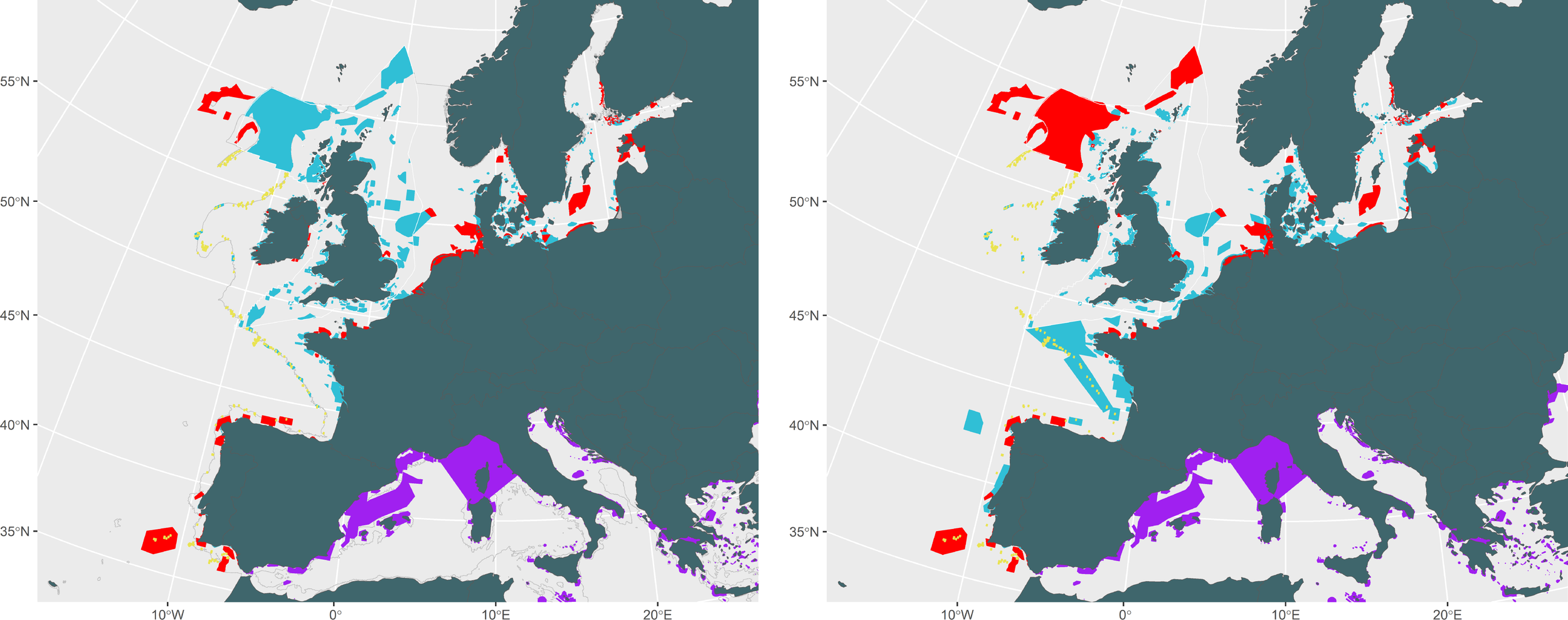
Natura 2000 sites and other MPAs in Northeast Atlantic region (blue: no restriction implemented yet, red and yellow: restrictions in place, source adapted from Bastardie et al., 2024a) for (left) all of those sites deemed vulnerable to bottom trawling, and (right) all of those sites deemed vulnerable to passive gears. In purple, regional Natura 2000 sites and nationally designated protected sites in the EU Mediterranean Sea (source: Hogg et al., 2024 – MAPAFISH-MED project).
For the North Sea, we compiled publicly accessible data sources for offshore wind farms (OWFs), starting with OSPAR and Emodnet databases (see Supplementary Materials for references to the used databases). Both Emodnet and OSPAR offer OWF polygons for the entire North Sea region, but certain areas, especially regarding future OWFs, were lacking and therefore added from national marine spatial plans. For the OWF-future scenario, data sources for planned OWFs and development sites between 2030 and 2040 were gathered (see Supplementary Materials).
We selected case studies from different EU sea basins, given the specificities of the different fisheries in these areas, as well as the parameterized models available. We used multiple modelling tools to predict and evaluate trade-offs between different uses of each case study. For example, models simulated the impacts of various fisheries management scenarios on fish stocks, biodiversity, and economic outcomes. This allowed us to assess the consequences of prioritizing one sector and identify solutions that align with the principles of EAFM. A good example was to examine how spatial planning for wind farms was likely to affect fishery access and ecosystem health.
The overview of model evaluations (Tables 1-4) shows the dynamic spatial fishery models (Figure 2) used to assess fishing efforts under new regulations for spatial restrictions and ecological conditions as designed by fisheries experts, to examine the i) the impact of management on fish stocks and fisheries, ii) benthic states and bycatch dynamics, and iii) influence of a climate change trajectories. The common feature of these models is that they are all designed to simulate the internal dynamics of fisheries and/or marine ecosystems using a process-based approach instead of a statistical approach. This allows for the application of various scenarios. However, the downside of these models is that they are computationally demanding to parameterize, run, and have slightly different scopes (e.g. the time horizon between tactical short to medium term effect evaluation) and capabilities (e.g. constant fishing effort vs effort dynamics). Additionally, if a sensitivity analysis is feasible, it is time-consuming to explore the entire range of parameters due to their large numbers. To address uncertainty in the predicted effects, we present results of several models for comparison. However, addressing uncertainties within each model was left to individual model-related publications and only average outcomes are presented here for simplification. The Supplementary Materials describe the different model methodologies. Closure scenarios were contrasted against a baseline, for which all implemented closure areas apply, including Natura 2000, FRAs, MPAs, and areas of biological conservation. These areas add up to the existing legislation. Hence, in the Mediterranean Sea, based on the EU legislation, trawling is prohibited within 1.5 nm nautical miles at any depth off the coast, or within the 3 nm for all locations less than 50 m deep (EU Regulation 1967/2006). Additional restrictions (in the Mediterranean Sea) particularly for trawlers are based on national legislation or FRAs established by the GFCM (e.g. trawl ban > 1000m depth).
Table 1
| Modelling approach | Scenarios | Outcomes |
|---|---|---|
| Dynamic with DISPLACE bioeconomic fisheries dynamics model (Maina et al., 2021) | Status quo. Modelling Otter Bottom Trawl (OTB), Purse Seine (PS), Gillnet (GNS), Trammel net (GTR), Set longline (LLS) fleet segments | |
| Restricting bottom trawl in the Natura2000 areas proposed during the 9th Our Ocean Conference (OOC-9: https://www.ourocean2024.gov.gr). | Natura 2000 restrictions – Minimal impact on catches, economic performance, and minor stock benefits. | |
| Restricting bottom trawling in all MPAs. | All MPA ban– effort displacement effect occurs for bottom trawlers, bycatch is increased, profits are reduced for bottom trawlers and small-scale vessels, minor stock benefits. | |
| Restricting bottom trawling in areas that are sensitive to benthos. | Sensitive benthic area restrictions – Limited effects; actual benefits for benthos need further investigation. | |
| Restricting bottom trawl from hake nurseries (space-time closure) | Spatiotemporal closures for hake – Increase SSB for hake with low economic impacts but fewer benefits for other species, the fishing effort displacement effect occurs for bottom trawl vessels. | |
| Restricting bottom trawl from hake nurseries (space-time closure) and overall fishing effort reduction of 15% for all fishing gears. | Closures for hake and concomitant effort Reduction slightly reduce fishing mortality, increase SSB, and reduce bycatch with moderate economic impacts for bottom trawl and small-scale fishing. A fishing effort displacement effect occurs for bottom trawl vessels. | |
| Restricting bottom trawl from hake nurseries and performing an overall fishing effort reduction for 15% (of all fishing gears) considering the effects of climate change (RCP 8.5) | Natura 2000 restrictions – Minimal impact on catches, economic performance, and minor stock benefits. | |
| Dynamic with ECOSPACE (Bastardie et al., 2024b) | Status quo. Modelling all fishing activities (otter trawls, purse seines, beach seines, longlines & trolling lines, nets, traps, and recreational fishery). | |
| Restricting bottom trawl (OTB) on the Natura 2000 areas proposed by the 9th Our Ocean conference for the Eastern Ionian Sea (OOC-9: https://www.ourocean2024.gov.gr). | Closures to bottom trawls in Natura 2000 areas - highest total and fish catches and a slight decline in biomass, suggesting that it can enhance fishing productivity without severely compromising the long-term sustainability of the stocks. | |
| Spatiotemporal closure for bottom trawl (OTB) in hake nursery areas. | Closures to bottom trawl in hake nursery areas - slight increases in catch indicators, apart from total catch. | |
| Restricting bottom trawl (OTB) in All MPAs. | Closures to bottom trawl across all MPAs - subtle positive effect on biomass indicators and negative impact on catch indicators. | |
| Spatiotemporal closure for bottom trawl (OTB) in hake nursery areas, RCP8.5 and a 15% Fishing Effort (FE) reduction for all gears. | The combined scenario - most advantageous for stock biomass and IUCN species biomass with a detrimental effect on catch indicators and catches of commercial species. |
Main outcomes of scenario exploration in the Ionian Sea using the suite of fisheries-centered models to predict how changes in ‘fishable’ areas affect fisheries and ecosystems in this region and fisheries.
Figure 2
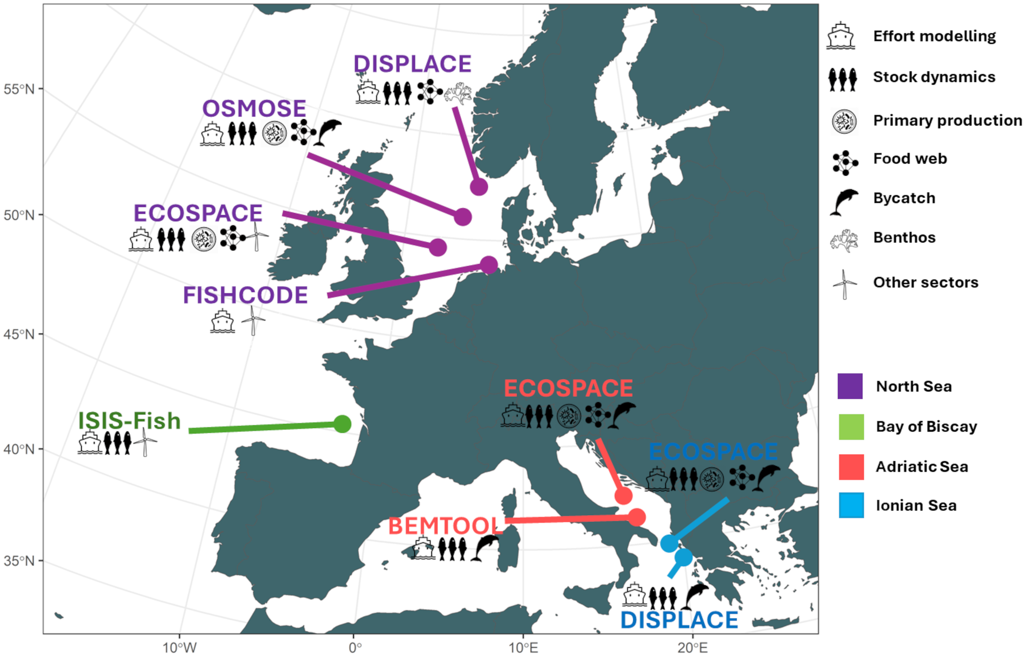
Different models and case studies across EU waters. See the description of the used models in Supplementary Materials. These models were ECOSPACE (Walters et al., 1999), OSMOSE (Shin and Cury, 2001), ISIS-Fish (Mahévas and Pelletier, 2003), DISPLACE (Bastardie et al., 2014), BEMTOOL (Rossetto et al., 2015), and FISHCODE (Letschert et al., 2025).
The suite of tested closure scenarios for spatial conservation areas that are anticipated to be efficient (fit-for-purpose, hereafter) in achieving the ecosystem-based conservation goals (Table 1) was designated within the SEAwise project (Astarloa et al., 2023; Bastardie et al., 2024a) and, in some EU regions, was partly based on stakeholder input about best placement. Fishers usually have a minimal involvement in the designation process of MPAs (Feary et al., 2025). Since MPAs, contrary to fisheries-specific closures, are established primarily to preserve hotspots of biodiversity, the focus is mainly on conservation rather than on incorporating the perspectives of fishers. Hence, we designed spatial restrictions scenarios i) to limit the bycatch risk or ii) to reduce the risk of impairing the seafloor integrity, respectively based on accurate observations or predictions (such as the one provided by species distribution models SDMs) of where the marine ecosystem components distribute, i.e. fish (ICES WKFISHDIS2), benthos (ICES WGFBIT), and cetaceans or other animals (Virgili et al., 2024; Astarloa et al., 2024). Hence, the bycatch and the seafloor impact are assessed in two different ways; on one hand, the areas are tested to be restricted to reduce bycatch of certain species or seafloor impact, and on the other hand, bycatch or seafloor have been assessed as output indicators.
The spatial restriction scenarios we tested are detailed in Tables 1-4 for each region and case study, aligning with the outcomes of the simulations. To create the summaries presented in Figures 3, 4, we aggregated scenarios to simplify the analysis and enhance generality. Specifically, the “existing MPAs” group combined current MPAs with concessions for offshore wind farms, focusing solely on those specific to the North Sea (given data availability and expertise involved). In this case, the wind farms are assumed to act as passive protection without allowing fishing. Meanwhile, the “fit-for-purpose” group (FTP) scenario included all other tested combinations. Ultimately, the climate change effect (CC) emerged as a significant factor. Detailed information on the pooling process can be found in the Supplementary Materials, which provides comprehensive figures supporting the more general summaries in Figures 3, 4.
Figure 3
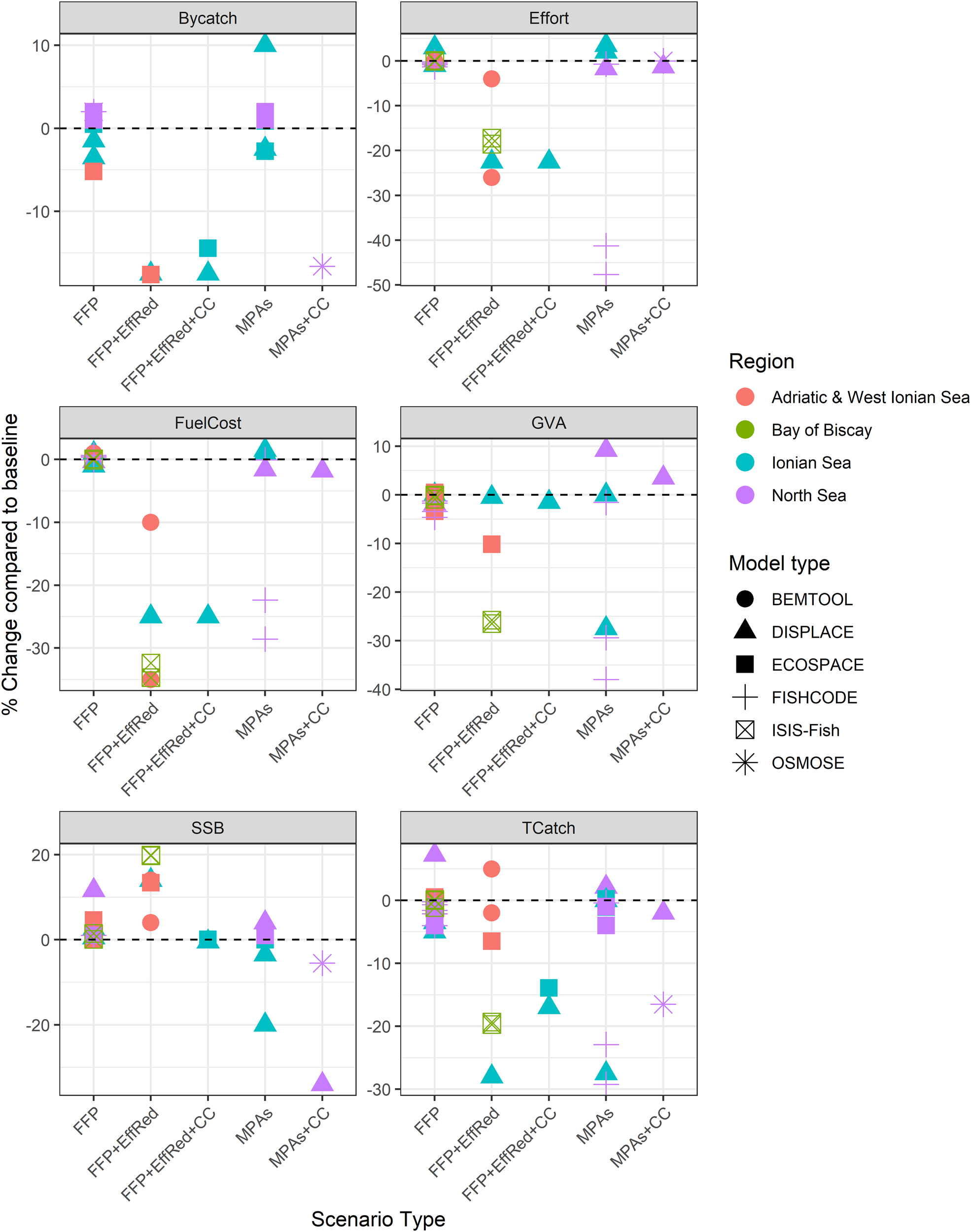
Percent change relative to the baseline run for each model type and case study, with FFP is the fit-for-purpose proposals for protection, contrasted against implementing restrictions in existing MPAs network, and EffRed an effort reduction implemented aside, and CC marking the climate change effect included. Fit for purpose were proposals aimed at protecting the Benthic community and habitats (delineating 30% around the higher Relative Benthic Status RBS areas), and delineating areas that are anticipated to reduce the risk of bycatch of sensitive species. Scenarios have been grouped by scenario type. Indicators are: Total effort, Total catch across all species, gross value added GVA, Fuel cost, spawning stock biomass SSB all species pooled, and bycatch weight caught. The impact is to some extent dependent on the closed surface area and the overlap with the ongoing fishing activities, which vary across scenarios, making variable the proportion of total effort that will be displaced. Note that not all model types have had time to run each scenario.
Figure 4
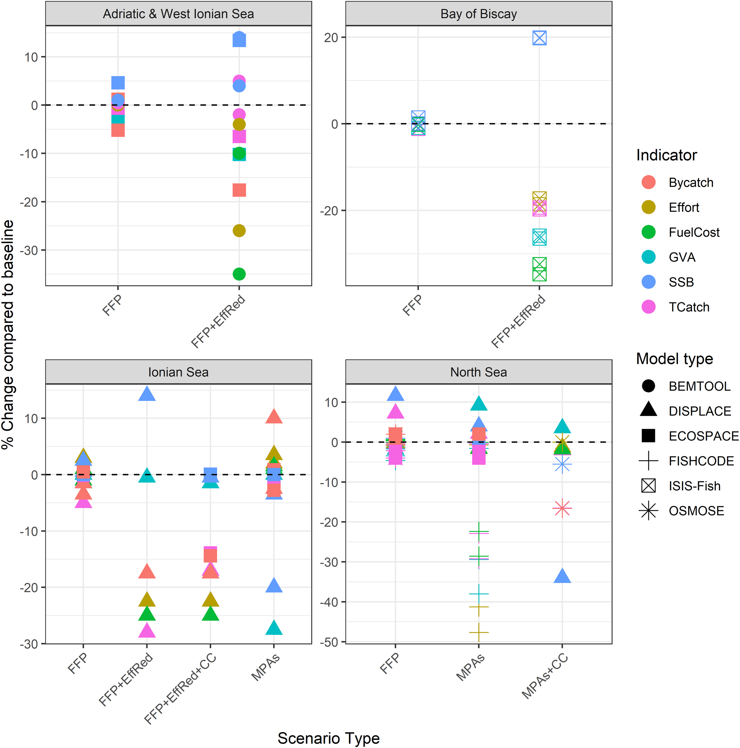
Same outcomes plotted as Figure 3 by enabling cross-comparison of models for a given ecoregion.
3 Results
3.1 Cross-model outcomes and case studies comparison
We calculated the percentage change relative to the baseline run for each model type and case study (Figures 3, 4). The cross-model comparison of output indicators reveals that the effectiveness of current MPAs in reducing bycatch risk varies depending on the specific case study. While some MPAs may adequately address this issue, others do not; MPAs designed with a purpose (FFP) may mitigate the risk associated with bycatch but also necessitate effort reductions linked to spatial restrictions.
In the short term, fishing effort tended to decrease when displacement of fishing effort or redirection toward other fishing activities is not an option (as in FISHCODE, used for the German fleet in the southern North Sea, see further below). However, if displacement is possible, there was a tendency for increased effort in the short term due to lower catch rates (DISPLACE Ionian Sea) or decreased effort when focusing on more productive areas and/or protecting stocks (DISPLACE North Sea). Implementing an effort reduction scheme could have significantly aided rebuilding spawning stock biomass by drastically cutting catches in the near term (DISPLACE, ECOSPACE, ISIS-Fish). Nonetheless, we lack sufficient data and evidence to ascertain whether these stocks will recover long term. Long-term forecasts are bound by large uncertainty given other factors such as food web dynamics (ECOSPACE), but also especially considering the potential reduction in future fishing opportunities caused by climate change (OSMOSE). ECOSPACE and OSMOSE are tools to investigate the long-term effects on stock recovery.
3.2 Fisheries in the Eastern Ionian Sea
In the Eastern Ionian Sea, findings with two modelling approaches (DISPLACE and ECOSPACE) regarding fishery management highlight several key points. The DISPLACE model indicates that combining the closure of hake nursery grounds with a reduction in fishing effort has proven to be the most effective strategy for conservation (Table 1). However, there are potential downsides to restricting otter trawl gear within MPAs. This restriction may lead to adverse effects, particularly when exposure and risk scores rise in non-protected areas (Table 1). Hence, reducing the effort is still needed; however, how such a reduction would impact the socio-economy of small-scale fishers remains uncertain, warranting further investigation to balance conservation efforts with the livelihoods of local communities.
The DISPLACE model indicates that annual bottom trawl restrictions in certain MPAs proposed in the 9th Our Ocean conference have minimal effects on total catches and fisheries economics and demonstrate limited to counterproductive outcomes of the spatial restrictions for the modelled stocks (Table 1; Supplementary Materials). On the other hand, the broader ban tested of bottom trawling across all MPAs leads to an effort displacement into the second most productive fishing grounds and areas in the vicinity of the MPAs, decreasing SSB and increasing bycatch, and reducing economic performance by -25% to -30% depending on fishing gear and indicator (Table 1). Restricting bottom trawling in sensitive benthic areas (communities with median longevity > 10 years, Smith et al., 2023; Bastardie et al., 2024a), showed minimal impact on catches, bycatch, stock status, or fisheries economics, with potential effects on deep-water species and benthos requiring further investigation. Among the management options tested, combining hake nursery closures while simultaneously reducing overall fishing effort was the most beneficial for conservation of targeted and bycatch species. This approach reduces fishing mortality (~-3% for hake, -2% for red mullet, and -25% for deep-water rose shrimp), increases hake SSB (+13%), and decreases bycatch (-25% in total) (See Supplementary Materials). This option causes various economic impacts (from low to high, depending on gear type and indicator). The spatiotemporal closure of hake nursery areas increased hake SSB and had various economic consequences, but fewer benefits for other species.
Climate change effects on species distribution, abundance and stock status may affect the effectiveness of management measures, as indicated in our simulations (Table 1).
The ECOSPACE model applied to the Eastern Ionian Sea confirmed that excluding bottom trawling from MPAs led to increased fishing effort outside the MPA, especially in locations with the highest fishing effort. However, climate warming significantly affected the outcomes (Figure 3). Hence, the ECOSPACE and DISPLACE approaches agree that closures cause fisheries redistribution (for most scenarios tested), while climate change may alter the effects of the closures (Table 1). Therefore, the simulation findings suggested that the closure of bottom trawling should be accompanied by effort reduction, particularly a reduction of effort for small-scale fishing to allow the hake stock to recover in the area. A recovered hake stock (+12% in biomass) and mullet (+6% in biomass) would, however, affect other fisheries in the area as, for example, it is anticipated that the increased predation of hake on deep water rose shrimp will reduce fishing opportunities (- 17% catch) on this stock of commercial interest (Table 1), emphasizing the importance of including such trophodynamics effects in simulation models.
3.3 Adriatic & Western Ionian Sea (GSAs 17-19) marine ecosystems
In the Adriatic and western Ionian Sea, two modelling approaches (ECOSPACE and BEMTOOL) were used to simulate the effects of fisheries management. The ECOSPACE simulations predicted that implementing novel spatial management measures (Table 2), including essential fish habitats, would increase juvenile biomass, especially for red shrimps. When these closures were combined with reductions in fishing efforts to reach FMSY (fishing mortality at Maximum Sustainable Yield), there was a notable increase in overall species biomass and a decrease in juvenile bycatch of 34% for European hake in GSA 17-18. However, the contribution of the closure was minor compared to the effort reduction that achieving FMSY would induce. Closing fishing areas without effort reduction increased the bycatch of juveniles. The effort reduction (EffRed) scenario (here corresponding to a Pretty Good Yield, PGY, see e.g. Rindorf et al., 2017) also reduced juvenile catches of hake and red shrimps, further supporting the benefits of combined closures and management strategies. The simulations suggest that closures without effort reduction have negligible effects on ecosystem indicators across guilds and elasmobranchs. Conversely, when closure areas are combined with effort reduction (FMSY), apex fish predators and, to a lesser extent subapex demersal predators, benthic feeding invertebrates and demersal sharks show an increase in biomass (See Supplementary Materials).
Table 2
| Modelling approach | Scenarios | Outcomes |
|---|---|---|
| Dynamic with ECOSPACE (Bastardie et al., 2024b) |
Modelling 37 fleet segments for historical spatial restrictions (MPAs, FRAs) & status quo i.e. fishing effort limits to achieve FMSY based on Adriatic MAP(GSA 17 and 18; Recommendation GFCM/43/2019/5); for the Western Ionian Sea (GSA 19), aligned to the GFCM MAP (FMSY of European hake) combined with a fishing ban in deep-waters to replicate a catch limit (Recommendation GFCM/45/2022/6). In combination with Pretty Good Yield (PGY) fishing effort reduction, as defined in Bastardie et al., 2024b (European hake and deep-water rose shrimp included). |
|
| Implementation of a new FRA moving the current fishing ban from 1000 to 800 meters depth; the bamboo coral Vulnerable Marine Ecosystems (VME) (Resolution GFCM/43/2019/6) in the southern Adriatic Sea; EFH where the juveniles are particularly concentrated for three important commercial species: deep-water rose shrimp, European hake, and giant red shrimp (Bastardie et al., 2024b); the hotspot for the longnose spurdog (Bastardie et al., 2024b); Areas where the relative benthic state (RBS) is < 0.8 (Bastardie et al., 2024b). | Increase in biomass of juveniles of target stocks, but also in an increase in bycatch due to effort redistribution; an increase in adult red shrimp biomass, and an increase in catch of all commercial fish stocks; no substantial effect on ecosystem protection. Substantial increase in biomass and reduction of juvenile bycatch for all the target stocks; reduction of catch and value for all the fleets; increase of Apex fish predators; This scenario resulted in a lower loss in adult catches compared to Fmsy_closure, but was less effective than this in reducing juvenile bycatch and increasing Apex fish predator biomass. |
|
| Dynamic with BEMTOOL (Rossetto et al., 2015; Russo et al., 2017) |
Modelling 28 fleet segments for historical spatial restrictions (MPAs, FRAs) & status quo, i.e. in combination with fishing effort limits to achieve FMSY based on Adriatic Multi-annual plan (MAP); for the Western Ionian Sea (GSA 19), and aligned to the GFCM MAP combined with a fishing ban in deep waters to replicate a catch limit. All proposed closures in combination with Pretty Good Yield (PGY) fishing effort reduction (European hake and deep-water rose shrimp included). |
|
| A scenario combining all proposed closures, namely: the implementation of a new FRA moving the current fishing ban from 1000 to 800 meters depth; the bamboo coral VME; Essential Fish Habitat (EFH) where the juveniles of three important commercial species are particularly concentrated i.e.deep-water rose shrimp, European hake, and giant red shrimp; the hotspot for the longnose spurdog; areas where the relative benthic state (RBS) is < 0.8. | Exploratory outcomes only at this stage though: Fleet fuel consumption varies with increased costs for fleets having to steam longer to reach out to the fishing grounds; Mean length of catches of giant red shrimp (GSA19) and, to a lesser extent, of European hake in GSA17-18 remarkably improved Implementing FMSY significantly reduces fleet-wide fuel usage. |
Main outcomes of scenario exploration in the Adriatic Sea and western Ionian Sea using the suite of fisheries-centered models to predict how changes in ‘fishable’ areas affect fisheries and ecosystems in this region and fisheries.
The BEMTOOL model reveals that fleet fuel consumption varies by location, particularly for the fleets exploiting fishing grounds where the nursery areas of European hake, deep-water rose shrimp and giant red shrimp are located. Some increased costs are shown for specific fleets having to steam longer to reach out to the fishing grounds and savings on expenses for others when fishing is conducted closer to ports. However, implementing FMSY significantly reduces fleet-wide fuel usage, which is driven by an overall decrease in effort. This indicates that fishing closures effectively shift fleet distributions and influence fuel consumption. The simulations confirmed that reduced fishing pressure, especially on nursery areas, facilitates stock recovery while improving the exploitation pattern for giant red shrimp juveniles in the western Ionian Sea. Indeed, the mean body length of caught giant red shrimp in FAO GSA 19 and, to a lesser extent, of European hake in GSAs 17-18, remarkably improved in the closure scenario because the historically high fishing effort inside and around the nursery areas of the target species in the different regions was displaced. Overall, the results of the two models confirm that the closure areas alone would not be sufficient to revert the stock and ecosystem indicators towards management objectives of sustainability, and a reduction of fishing pressure is needed. The closure areas alone and in combination with effort reduction can contribute to improving the exploitation pattern of the target stocks, when the closure is tailored to the protection of nursery areas.
3.4 International fisheries in the North Sea
The DISPLACE model suggests that excluding bottom fishing from MPAs can significantly improve benthic health in protected areas. It also indicates that protecting 30% of areas with currently high RBS (Relative Benthic Status) can benefit long-lived benthic groups while incurring low costs for fisheries (Table 3).
Table 3
| Modelling approach | Scenarios | Outcomes |
|---|---|---|
| Dynamic with FISHCODE (Letschert et al., 2025) | Status quo modelling German fleets in the southern North Sea (Beam trawl, Otter bottom trawl fleet segments). | |
| Fit-for-purpose MPAs based on vulnerable benthic communities excluding all fishing inside. | Fishing effort of beam trawlers catching shrimp and otter trawlers decreased in all scenarios, whereas it increased for beam trawlers targeting flatfish. Profits decreased in all scenarios for all fleets, showing that adaptations (switching fishing areas and métiers) could not mitigate economic losses by closed fishing areas. The strongest economic loss occurred in the scenario of closing designated MPA areas to shrimp fishers (up to 50% loss). |
|
| Fit-for-purpose MPAs to reduce bycatch of elasmobranchs excluding all fishing inside. | Fishing effort of beam trawlers catching shrimp and otter trawlers decreased in all scenarios, whereas it increased for beam trawlers | |
| Fit-for-purpose MPAs excluding all fishing inside and based on potential MPAs given future OWFs combined | Fishing effort of beam trawlers catching shrimp and otter trawlers decreased in all scenarios, whereas it increased for beam trawlers. Scenarios with large area closures resulted in a systematic increase in fishing effort in the remaining open areas. |
|
| Dynamic with OSMOSE (Binch et al., in review) | Status quo. Modelling the activity of 14 fleet segments (11 bottom trawl and 3 pelagic trawl gears) FMSY (no MPAs or OWFs). | |
| Climate scenario RCP8.5 2060 (FMSY effort). | Relative change in the typical length of the food web shows a reduction under the climate scenario Total biomass decreased under climate and climate plus effort redistribution scenarios relative to baseline. Catch above legal landing sizes increased, due to the increase in the proportion of mature fish in the food web. |
|
| Climate scenario RCP8.5 2060 + No effort in MPAs (Bottom Trawl BT restriction) and OWFs (BT + Pelagic Trawl PEL restrictions) (FMSY total effort redistributed). | Relative change in the typical length of the food web shows a reduction (but less pronounced compared to no MPA) under the climate scenario Total biomass decreased under climate and climate plus effort redistribution scenarios relative to baseline. Landings of all species are reduced under both scenarios, with spatial closures in combination with climate leading to lower yields. Sandeel (Ammodytes tobianus) shows the only positive response to spatial closures under the future climate scenario due to fishing restrictions implemented over the large Dogger Bank MPA. |
|
| Dynamic with DISPLACE (Bastardie et al., 2020) | Modelling “status quo” for international fleet segments with FMSY as a target for each stock, under “min” scenario i.e. the fleets/métiers stop when the first quota is exhausted | · · |
| All bottom trawling phase out from current MPAs by 2030 (EC, 2023). | Displacing fishing activity outside the restricted zones resulted in higher simulated catches, while declining stock biomasses were only marginally positively affected. | |
| Fit-for-purpose MPAs for protection of sensitive habitats (30% of high relative benthos status RBS habitats as in ICES WGFBIT 2023). | No large change in Relative Benthic Status (RBS) after implementing restricted areas at the regional scale, but large gain within the closed areas. | |
| All bottom trawling phase out from current MPAs by 2030 (EC, 2023) assuming climate change effects on life history traits (i.e. growth). | The long-term profitability decline induced by climate change productivity loss (declining SSB) will be less severe if closures are implemented. | |
| Dynamic with ECOSPACE (Püts et al., 2020) | Status quo modelling 12 fleet segments in the Southern North Sea, including beam trawling and passive gears. | |
| Fit-for-purpose MPAs based on vulnerable benthic communities excluding all fishing inside. | Fish biomass increased by ca. 9% inside the closure; however, this increase was not enough to outweigh the reduction of biomass outside the MPA. The closure of the MPAs led to an overall decrease in catches. While catch volume losses among all fleets were up to 42% inside the closures, we saw an increase of up to 10% in catches outside the closures. However, this increase did not outweigh the losses caused by the closures. | |
| Fit-for-purpose MPAs to reduce bycatch of elasmobranchs excluding all fishing inside. | The outcomes showed gain in biomass of the sensitive species inside the MPAs, but the spatial restrictions came with increased risk of bycatch sensitive species outside the closed areas. | |
| Fit-for-purpose MPAs excluding all fishing inside and based on potential MPAs given future OWFs combined | Scenarios with larger and more closures (i.e. including habitat protection) displayed the strongest effect. |
Main outcomes of scenario exploration in the North Sea using the suite of fisheries-centered models used to predict how changes in ‘fishable’ areas affect fisheries and ecosystems in this region and fisheries.
Table 4
| Modelling approach | Scenarios | Outcomes |
|---|---|---|
| Dynamic with ISIS-Fish (Mahevas et al., 2024; Vajas et al., 2024; Ricouard, 2024) |
Modelling French, Spanish, UK and Belgium demersal fleets, 41 demersal fleets, 431 métiers (combination of a gear, location and mix of target species) status quo i.e. all seasonal closures were tested with (i) A status quo scenario, sq, representing the average historical conditions (constant effort) and used as a reference, and (ii) a min scenario consisting in the adoption of the ICES FMSY harvest control rule and the full implementation of the landing obligation | |
| Reducing common dolphin’s bycatch: Closing in Bay of Biscay area during Autumn and winter for gillnets, bottom trawling and pelagic trawling. | Negatively affects the economy of larger vessels by restricting their offshore fishing grounds on the continental slope. Coastal fleets practicing both active and passive gears may benefit and are anticipated to improve their economic return. |
|
| Reducing Balearic shearwater’s bycatch: closing high abundance of Balearic shearwater area from June to November for liners (LL); closing medium-high abundance of Balearic shearwater area from June to November for liners (LL) | Balearic shearwater closures effect is negligible. |
Main outcomes of scenario exploration in the Bay of Biscay using a fisheries-centered model to predict how changes in ‘fishable’ areas affect fisheries and ecosystems in this region and fisheries.
The ECOSPACE model tested the effect of designating no-take zones and offshore wind farms (OWFs) in the North Sea marine ecosystem. Overall, the simulated impact on fish stocks and other marine species of no-take zones (in FFP MPAs that were designed based on relative benthic state and to reduce bycatch) was stronger than for existing MPAs and OWF concessions, as they closed larger coherent areas (Table 3). The simulations showed biomass gains inside closed areas, both on fish biomass (9%) and the deemed vulnerable species under examination (8%). Fish catches increased around closed areas in all cases, suggesting strong edge effects. This was particularly visible when closing regions to protect sensitive benthic areas in combination with OWFs. In this scenario, a great proportion of the southern part of the North Sea is closed for fisheries and the remaining fishable areas are fished increasingly, with fishers “fishing the line” (as in Kellner et al., 2007) (see Supplementary Materials).
The FISHCODE model, an agent-based model emphasizing fishers’ decision-making, explored the effect of no-take zones and OWFs on fishing effort and profits of three German fleets in the southern North Sea. Closing potential (but currently not enforced) MPAs had the strongest negative effect on profits, catches, effort, and fuel costs, while other tested scenarios (suggested fit-for-purpose MPAs to reduce bycatch and protect benthic habitats, and OWFs) had weak or moderate effects on profits (Table 3). All scenarios reduced fishing effort for the fleets catching common shrimp and demersal species using bottom trawls, whereas the effort of the fleet targeting plaice and sole increased. Profits decreased for all three fleets, and this was most pronounced for the brown shrimp fleet in scenarios closing potential MPAs, because they heavily overlap with coastal shrimp fishing grounds, and affected agents (fishers) had to travel further, which increased their fuel costs and lowered their fishing time. Potential MPA scenarios also partially closed fishing grounds of trawlers targeting plaice; however, they maintained their level of fishing effort through switching to an alternative métier targeting more Nephrops than plaice (Supplementary Materials). Due to all tested fishing closures, fishing effort in the remaining open areas increased. In the scenario with closed areas induced by future OWF and protection of the benthos, which represents the largest closed fishing area, fishing increased by at least 50% in 25% of all fishable grid cells. The impact of fisheries on the ecosystem is not explicitly simulated in FISHCODE; however, more fishing effort is expected to add extra pressure on the still-open-to-fishing seafloor since all simulated fisheries used bottom-contacting gears.
The North Sea OSMOSE model was used to investigate the effects of climate change under a future Representative Concentration Pathways (RCP) 8.5W/m2 until 2060 scenario and climate effects in combination with spatial management. Restrictions of bottom trawling in MPA and OWF areas, and pelagic trawling restrictions in OWFs were tested with a proportional redistribution of fishing effort to still-open-to-fishing areas where the respective fishing technique was active (Table 3). An overall reduction in higher trophic level biomass by ~7.5% was simulated for both climate and climate and spatial effort redistribution scenarios (Supplementary Materials). This implies that despite spatial effort changes in fishing activity, bottom-up control, governed by climate effects, is likely to drive observed changes at current effort levels. Other biological indicators, including typical length (TyL) and proportion of mature biomass (PropM), show less severe changes, relative to baseline conditions, when spatial closures are implemented, across most species’ groups. In parallel, the vulnerable species (Endangered, Threatened and Protected, ETP, classified species (by the IUCN) were adversely affected when spatial effort is redistributed outside of closed areas. However, a large (>10%) biomass increase of the low trophic level group (benthic planktivorous) was observed inside the closed area (Supplementary Materials, baseline 2018). This can be explained by the high density of sandeel over the Dogger Bank area, which overlaps with a large MPA designation. By contrast, an overall reduction in catch of higher trophic level fish species by ~7.5% was also simulated for the climate scenario, but more than double the reduction, >15% was simulated for the climate and spatial effort redistribution scenario (Supplementary Materials).
3.5 French fisheries in the Bay of Biscay
The impact of fisheries measures in the Bay of Biscay varied among the combinations of fit-for-purpose closures and scenarios on the overarching management in place. The overarching management was determinant in the contribution of the spatial restrictions to achieve conservation goals (Figures 3, 4, FFP vs FFP+EffRed). Hence, whatever the spatial restriction, the scenario assuming full compliance with the MSY-based management and landing obligation led to a strong reduction in fishing effort. This decrease in fishing pressure benefited the exploited populations with an increase in SSB (Figure 3), along with the decline in catch and profit. In the long term, however, the benefits of stocks rebuilding would partly compensate for the loss of profit induced by effort limitations (see Supplementary Materials).
The ISIS-Fish simulations showed that the effects of offshore restrictions aiming to reduce bycatch of common dolphin (Delphinus delphis) in the French area of the Bay of Biscay would affect the profit of larger (>15m) vessels, narrowing their fishing grounds to the continental shelf, while coastal fleets using a mixture of gears may benefit economically. Most positive or negative economic impacts of closures on fleets are within -/+ 15% of the gross value added in the short/medium term (10-year horizon, see Supplementary Materials), mainly reflecting changes in the accessibility of target species to fisheries. If the landing obligation (LO) did not apply, closing the area would have almost no effect on the total fishing effort of individual fleets, meaning they successfully compensate for the loss of effort by increasing activity in the portion of their fishing zone that remains open, whereas, if the LO applied, fisheries are closed early in the year. On the contrary, the spatial restriction under the LO led to an overall increase in the fishing days deployed at sea by making the vessels less efficient (meaning lower catch rates) in the short run (between 0 and +8%, see Supplementary Materials). All the offshore closures tested had indirect consequences for commercial fish stocks. These closures enhanced the biomass of megrim (Lepidorhombus whiffiagonis) and anglerfish (Lophius piscatorius), typically distributed further offshore, as the displacement of fishing effort away leads to lower mortality in the closed area.
Effects of coastal restrictions aiming to reduce the bycatch of Balearic shearwaters (Puffinus mauretanicus) were much more limited, and no significant consequences for commercial fish stocks were observed, which is a positive outcome. Despite some coastal fleets and especially longliners having a substantial proportion of their fishing zone covered by the MPAs, all fleets directly affected by the MPAs can reallocate their effort outside, but with interactions between them (Supplementary Materials). Notably, the longliners under 10 m, with the highest overlap between fishing zone and the MPAs, are also the most negatively impacted by the MPAs. No substantial differences were observed between short/medium and long-term projections. The overall low impact of the coastal MPAs in comparison with offshore restrictions is consistent with the smaller proportion fleets concerned. However, the fishing grounds for small, coastal vessels were possibly assumed in the model to be larger thanthey are, which may overestimate vessel displacement opportunities. In summary, closures have low impacts compared to effort reduction but provide interesting synergies, notably to mitigate long-term economic losses.
4 Discussion
4.1 Strengths and weaknesses of the spatial fisheries dynamics modelling approach
EU fisheries face serious challenges threatening the marine space available to fishing. Besides capture activities themselves threatening future fishing opportunities whenever degrading supportive habitats, human factors like habitat degradation (Patti et al., 2022), marine pollution (Vagi et al., 2021), eutrophication (Solidoro et al., 2009), acidification and warming waters (Bahri et al., 2021), invasive species (Galanidi et al., 2023), and fishing practices jeopardize future exploitation (e.g., a review in Bastardie et al., 2021). This multitude of pressures necessitates an adapted governance of EU fisheries (Drouineau et al., 2023; Bastardie et al., 2024a). Effective area closures would ideally translate into enhanced fish stocks, reduced bycatch and less seafloor damage and thereby may help preserve marine biodiversity and vulnerable species. Such an ideal situation would also mean safeguarding sensitive habitats essential for breeding and growth of many marine organisms (Kraufvelin et al., 2018). Protecting these areas would contribute to more resilient marine ecosystems. Closed or restricted areas would improve spatial selectivity beyond the usual gear selectivity, which would enhance the efficiency of fishing practices in ensuring long-term yield on commercial species while minimizing the impact on non-target species (Dunn et al., 2011). However, conservation measures limiting specific fishing techniques might come with reducing opportunities in some areas while pushing fishing efforts to nearby locations. This redirection would alter catch composition and selectivity, potentially increasing operating expenses or, conversely, requiring less effort to maintain profit.
The last reform of the Common Fisheries Policy (CFP 2013, Art. 11) introduced the possibility of aligning fisheries management in Europe with its environmental protection objectives as defined in the Marine Strategy Framework Directive (MSFD), EU Habitats Directive, EU Birds Directive, and other directives, which are inherently implemented at the national level. To implement cross-border protection, the European Commission (EC) can propose new legislation that follows joint recommendations issued from a colloquium of EU Member States in the CFP regionalization process (CFP Art. 18). While the responsibility of implementing the ecosystem approach ultimately lies with Member States, a growing number of delegated acts are being adopted to include recommendations for more selective gears, less impactful gears, or closed areas to maintain seafloor integrity and monitor trophic guilds to ensure the functioning of marine food webs (see EC COM (2023/520)). This represents a well-intended opportunity to establish case-by-case restrictions on fishing in existing and future MPAs that are purposeful and well-agreed upon by the Member States, after consultation with various stakeholders, including the EU Advisory Councils (Art. 3 of the CFP about principles of good governance).
When comparing ecosystem structures and functions between non-fished areas (like MPAs or offshore windmill farms) and fished waters, it is important to determine whether any benefits remain limited to the local area or spread and extend to a broader region, potentially creating new fishing opportunities. In this endeavor, when assessing the effects and potentials of spatial restrictions achieving conservation targets or purpose, several shortcomings and pitfalls can be identified (see Table 5 for a non-exhaustive list of them we identified alongside our findings). Hence, area-based management options require scientific documentation of their performance ahead of the implementation to be effective. Usually those evidence-based insights are not issued from field observations and experiments, given the difficulty in finding and analyzing real-life fishing effort displacement and in collecting relevant data. Hence, in the field, there is limited possibility for applying rigorous approaches and appropriate metrics, as some indicators may not respond to fishing impacts. This raises concerns about how protected areas are assessed, habitat and biodiversity preservation are proven, and subsequent fisheries benefits are supported (Table 5 #4). Capturing the closure effects suggests using B(efore) A(fter) C(ontrol) I(mpact) designs in studies to evaluate management measure impacts more effectively. Often, the BACI scheme is ignored, and the adopted methods confound pre-existing differences with the impact (e.g., see the meta-analysis in Sciberras et al., 2018 on macrobenthos or evidence for spillover effects in Van Hoey et al., 2024). Also, closed areas should not be compared solely to adjacent open areas, which can have fishing effort displaced into them (Table 5 #4). Lack of empirical evidence highlights the necessity of using spatial modelling to advise on the performance of spatial fishing restrictions.
Table 5
| Confounding points | Explanations | References |
|---|---|---|
| #1 The effect of the protection of MPAs is minor because low-quality habitats are protected first | No tremendous gain arises from protection whenever the protected areas are of poor quality and have low potential to host diverse ecological communities because they are shaped by factors unrelated to fishing, which limit the potential (e.g., eutrophication). Designating relatively low-value, low-effort areas further reduces the risk of stakeholder conflicts. | This study; Fraschetti et al., 2018; Gavriel et al., 2025 |
|
#2 Some habitats, and the associated benthic biotopes are naturally prone to disturbance and have adapted to such perturbations |
A chronic fishing added to natural disturbance shapes the benthic communities in place (“shifting baseline”) toward the dominance of fast-growing, short-lived species. Hence, given the historical fishing patterns and intensity, some seafloors may have already adapted to high levels of trawl disturbance and benthic impact and would not recover to previous communities. | van Denderen et al., 2015; Nielsen et al., 2022; Hiddink et al., 2023 |
| #3 Some designation of restricted areas will never contribute to protect certain species whenever area size effect and spatial connectivity features are being ignored | Mismatches between spatial features and species characteristics such as “home range,” migratory patterns, and mobility or ability to disperse and subsequent spillover scales compromises the effectiveness of the protection measures. Also, larger fish could play a disproportionate role in driving the dynamics of fish populations. An ecologically coherent network of smaller areas would maintain those. | This study; Lester et al., 2009; Sciberras et al., 2015; Marshall et al., 2019; Giakoumi et al., 2025 |
| #4 Effort displacement and subsequent effort concentration makes spotting the MPA effect challenging | Demonstrating the effects of MPAs using a rigorous BACI design (Underwood, 1992) can be challenging, as displaced fishing effort may shift to surrounding areas, potentially impacting control sites and confounding the comparison Such an effort concentration (“crowding effect”) and other “fishing the line” effects will affect surrounding habitats and catch ratio in a twofold way: i) productivity on the affected areas whenever more effort occur locally, ii) Mutually exclusive fishing activities among different gears can reduce the attractiveness of certain fishing grounds, especially when informal agreements or ‘tactic rules’ exist among fishers for sharing marine space | e.g. Osenberg and Shima, 2011; Caveen et al., 2013; Quirijns et al., 2007; Gavriel et al., 2025 |
| #5 Higher yield alongside more effort deployed may mask degraded ocean productivity | Fisheries yields and ocean productivity are expected to increase concomitantly. Unfortunately, the reverse pattern is currently observed in the Mediterranean, with the higher yield not being sustained by underlying higher ocean productivity but by more effective fishing effort deployed instead, as a symptom of ongoing non-sustainable exploitation of the exploited species and the marine ecosystem in this area. | Druon et al., 2021; Hidalgo et al., 2022 |
| #6 Certain practices will likely be allowed to continue fishing within MPAs deemed vulnerable to mobile bottom fishing, with a further attraction effect to the protected areas | For now, alternative fishing methods, like pots or bottom-set nets, are often not economically viable in the present state under degraded productivity, or it may also not be possible to catch the same species for which the company has a quota unless quotas are exchanged. Protected MPAs might change this and attract fishing that overestimates the gain in stock abundance or spawning stock biomass within the closed area. | Renn et al., 2024 |
| #7 Implementing marine reserves should not be considered a sufficient measure to manage the fisheries and reach biodiversity conservation goals | In some cases, MPAs may do more harm than good when effort is displaced. Therefore, complementary fisheries management measures would be required, for example, reducing fishing effort. MPA designations that do not align with other environmental management (EU MSFD, MSPD) pose risks arising from factors unrelated to fishing, including human impacts affecting the protected and unprotected areas. | This study; Vaughan, 2017; Dimarchopoulou et al., 2023; Maina et al., 2021 |
| #8 Large fishing companies may misleadingly claim that MPAs harm local communities. | MPAs can harm local fishers who might not benefit from the conservation if the locals are excluded from the traditional fishing grounds. However, by maintaining access to low-impact gears, MPAs are often designed to protect the interests of local fishers, fairness and equity, especially against large corporations that are typically disconnected from these communities and take less care of local effects. | Jones et al., 2013; Bennett et al., 2015; Dinesen et al., 2018 |
Some confounding factors or shortcomings to examine whenever assessing spatial management effects and performance.
Describing fisheries’ effort allocation in response to factors influencing decision-making (social, economic, ecological, institutional) is also challenging. Both environmental and economic effects depend on the mobility of the fishing fleet itself, which requires modelling of how fleets would be affected by changing the fishable areas. The effect may differ among small-scale fishing that are often more polyvalent on their catch portfolio but less mobile, and large-scale fishing vessels that can steam longer distances but are often more specialized in the species they target (Salas & Gaertner, 2004). Moreover, fishing behavior may differ depending on cultural background and company structure (Schadeberg et al., 2021). On the ecological side, the effect may vary if the closure is seasonal or only spatial. For example, if vessels are very mobile, seasonal closures, where presumably all areas are closed in a season, could increase the homogeneity of overall disturbance by redistributing the effort on other seasons of the year. On the contrary, spatial closures could intensify the pressure on the remaining areas, making the pressure on habitats uneven. Both spatial and seasonal closures could lead to the redistribution of fishing activity to environmentally sensitive or previously unfished or relatively preserved areas. Bioeconomic models with more flexibility in simulating human behavior and fishers’ decision-making, both in space and time, are a way to evaluate the potential effects of including fisher behavior in model simulations. Models deployed in this study have captured some of these dynamics with more realism in describing and anticipating change in fisheries, such as changes in catchability per species (Bastardie et al., 2020; Maina et al., 2021), spatially and seasonally (Bastardie et al., 2020; Maina et al., 2021), and feedback from population dynamics (Bastardie et al., 2014; Maina et al., 2021) or foodweb dynamics (Romagnoni et al., 2015; Püts et al., 2023), a possible change in background economic landscape and fish market dynamics (Russo et al., 2017), complex fisher behavior beyond profit maximization and allows for the adaptation of métier choices (Letschert et al., 2025), etc. (See Supplementary Materials).
The crucial aspect of evaluating MPAs is determining spatial modelling approaches, like the ones we presented in this work, to provide complementary guidance for management decisions that includes such indirect effects of closures. Using several different models increases our confidence in the estimated effects, where these align and highlight areas where further investigation is needed where they differ. However, if the same models were applied in different regions (DISPLACE and ECOSPACE) they yielded various outcomes depending on the area, which makes it likely that the main differences do not arise from the models used, but rather because of inherent differences between fisheries and local circumstances. Comparisons across models within a region have been possible in two of the four regions investigated here, strengthening the results but highlighting the difficulty in developing and deploying appropriate models.
4.2 Performance in displacing fishing effort from MPAs
4.2.1 Performance of the protection and socioeconomic effects
On average, prohibiting specific fishing techniques in currently designated MPAs has minor impacts on the fisheries’ economy, fish populations, and ecosystem indicators. This is primarily because these areas are chosen due to their significance as hotspots of EU marine biodiversity rather than selected for a high abundance or productivity of fish species with a commercial value, high bycatch or high benthic sensitivity, and are often small, shallow or coastal, and with seabed features that make it difficult to fish effectively. These areas are only marginally used by fishers (and were often designed not to be). Hence, considering the surface area of the closure, the actual spatial overlap between the MPA and the areas where fishing occurs is a factor in the magnitude of the expected effort displacement. For instance, in the Bay of Biscay, the MPA includes very deep regions that remain unfished in the model. In addition, the areas actually are mainly visited by the largest vessels given their distance from the coast. Therefore, evaluating efficiency based solely on the entire MPA’s surface area may yield a biased perspective, while the positioning of the protection is also important (Table 5 #1). However, in a few instances, the impact of spatial restrictions can be substantial in the short term, as we showed particularly for the German fleet in the North Sea. This is mainly because the designated MPAs added to the possible site for OWFs settlement encompass the entire Wadden Sea as well as additional coastal regions, which significantly overlap with the heavily fished areas of German shrimpers, that contribute most fishing effort in the southern North Sea. Results from the respective model used for this scenario (FISHCODE) showed that adaptation of the shrimp fleet would be challenging, because fishing grounds further offshore required longer steaming times which, in turn, decreased fishing time and increased fuel costs. Even though closing all of the coastal waters of the southern North Sea would have a significant effect, it is in line with the EU Marine Action Plan (European Commission, 2023).
In some cases, the potential benefits of these restrictions can be significant, as the capacity for benthos recovery is greater when there is still something to preserve. For sensitive species, previous findings (Bastardie et al., 2024a) of a bycatch risk assessment performed in the same study areas showed that many species did not respond to the closure of existing MPAs, possibly because redistribution of fishing without a reduction of total effort is not efficient for reducing their mortality. In the present study, the scenarios investigated suggest that the prohibition of certain fishing practices, in fit-for-purpose (FFP) areas to limit the risk of incidental bycatch mortality and the degradation of the benthic state, may significantly adversely impact the overall fisheries economy and fish populations in the short-term. In the regions where both types of closures (current MPAs and FFP) could be tested (i.e. all but the Bay of Biscay), these targeted closures were more effective in protecting habitats and bycatch species than restrictions in the currently designated MPAs. This result was observed across models and systems, hinting at a generalized pattern rather than a model or case-specific result (see Figure 3). Based on dynamic fleet modelling and previous species distribution modelling (e.g. Püts et al., 2023), our findings also confirm that the effort displacement induced by fit-for-purpose closures would require a parallel reduction of effort to fully attain the desired effect (i.e. reduction of the seafloor and bycatch risk). In this study, we show that effective area closures can play a vital role in fisheries management by protecting juvenile fish stocks, thereby enhancing the survival of younger fish and a non-degraded habitat where animals can grow.
Conservation measures significantly affected the socioeconomic benefits derived from fishing, leading to reduced short-term catches, higher operational costs (e.g. higher fuel usage whenever fishers may have to travel farther to find fish) and lower profit. This was due to shifting fishing efforts to surrounding areas, which may further harm biodiversity (seafloor, bycatch species). Such effects must be considered as they place a financial strain on local fishing communities that rely on a steady income from their catches and, therefore, can induce resistance to change and impair the compliance of the fishing sector with the rules, with adverse long-term effects. Such spatial restrictions could also add to repeated fuel crises that lead fishers to modify their effort allocation by, for example, reducing the number of trips, the trip duration, going closer to the port, targeting fish with higher market value, or ultimately switching to a less fuel-consuming gear. As observed in the Bay of Biscay, the effects may also be fleet-dependent, where closures induced winners and losers. In this case, the MPA unexpectedly extended the fishing season by lowering the catch efficiency for certain species, as the quotas were being taken more slowly. On the other side, closing deeper areas along the slope, such as in the South Adriatic and Ionian Seas, forcing fisheries to redistribute on the upper slope and shelf, closer to shore in areas already exposed to high fishing pressure. Effort displacement can also occur when fishing activities are shifted to open areas, which may inadvertently cause harm to biodiversity in those previously unfished or lightly fished regions (Roberts et al., 2025). The potential effectiveness of spatio-temporal management measures also depends on the ability to monitor and control fishing activity on potential environmental/climate effects. The impact of effort reduction on small-scale fisheries remains uncertain due to the absence of vessel positioning systems (but see Regulation (EU) 2023/2842), necessitating further data and research, also creating uncertainty about how the small-scale sector will respond to such changes.
4.2.2 The need to combine spatial management with effort reduction and other management
Accordingly, implementing gear and time restrictions in MPAs should be combined with non-spatial management measures like effort limits and quotas to achieve desired outcomes, as shown by this study, along with proper governance to mitigate resistance to change. This should come with the right governance so that the fishers reducing their effort will also be the ones benefiting from the protection in the long run (Burgess et al., 2018, Bastardie et al., 2024a).
Indeed, the CFP enables fishing effort reduction, as in the ongoing West Med multi-annual plan (Regulation (EU) 2019/1022), which limits the days at sea allowance per vessel for the exploited stock to be reduced year after year to achieve the MSY. This reduction will likely continue in the West Med as the management targets remain to be met (e.g. STECF-20-13) but implementing spatial measures is also proposed as a complement to effort reduction. In the Central Mediterranean, where an improved status of key commercial stocks was recently reported (FAO, 2023; GFCM, 2024), in some cases, the exploitation level is still above reference points, and thus requires effort and/or catch limits, in continuity with ongoing subregional management plans (e.g. Recommendation GFCM/43/2019/5; Recommendation GFCM/45/2022/6). Nonetheless, combining such limits with spatial management in well-designed hotspots may improve the exploitation pattern, a critical issue for Mediterranean fisheries, making the local mixed fisheries more sustainable. In addition, in such fisheries effort-based management measures (e.g. fishing days) may not entirely reflect the actual fishing pressures on different stocks (STECF, 2020; Sun et al., 2023, see also Table 5 #5).
As an alternative to effort reduction, it would also be possible to change the approach by defining zones of authorization instead of zones of prohibition. Fisheries managers could restrict the spatial footprint of bottom fishing gear to focus on the main areas of the fishing grounds. This approach would help avoid the occasional bottom trawling events in less frequently visited areas (see, for example, Bastardie et al., 2020). This approach has been followed to protect vulnerable marine ecosystems (VMEs) within the 400–800-meter depth range in EU waters of the northeast Atlantic (European Union, 2016). Complementary to top-down management, market instruments such as implementing clear, transparent, fair and adaptable scoring systems of fisheries relative to their impacts can enhance societal awareness and steer the market towards more sustainable seafood products, whenever fishers would adapt fishing techniques and practices to limit their impact on the marine ecosystems (Grati et al., 2025).
4.3 Limitations of spatial measures to fisheries management
As the percentage of closed regions increases (to reach the 30% commitment of the EC Marine Action plan), the effort displacement effects will likely change. Therefore, area-based management should only be used in combination with other technical measures such as non-spatial gear selectivity improvement and continuation of effort control, including effort reduction and the transition toward alternative fishing techniques and implementing catch limits (Table 5 #7). Our findings are significant in the current debate about excluding specific fishing techniques from marine protected areas in EU waters to attain the aims of the Habitat Directive, MSFD and the recently adopted nature restoration regulation. In such an endeavor, several factors should be accounted for:
4.3.1 Sensitivity to spillover effects
In most cases, displaced effort may increase the risk of impacting vulnerable habitats and sensitive species when fishers concentrate their activity around closed areas in an attempt to offset lost fishing opportunities spatially. However, the effects of effort reduction may depend on spillover, particularly when fishers benefit from increased catchable biomass spreading from the MPA to surrounding areas. Spillover has been detected in a meta-analysis in Lorenzo et al. (2020) comparing biomass inside vs. outside within a strip of 200m from the limit of the MPAs, or captured in the field in e.g. Kerwath et al. (2013); Lynham and Villaseñor-Derbez (2024) or Franceschini et al. (2024). Some of our models accounting for spillover effects (diffusion in ECOSPACE, redistribution in DISPLACE) anticipate that the fisheries can benefit from stock enhancement induced by the spatial protection (see ECOSPACE outcome for the West Ionian and Adriatic Seas, for example).
Dynamic modelling also offers lessons that are not evident only by looking at historical closures. Assumptions in weighing factors influencing effort re-allocation are found to be key, as well as life-history traits (such as the ability to disperse depending on species). For example, in ECOSPACE models, two parameters, the dispersal rate and fleet effective power, influence the spatial distribution of species and fishing fleets (Romagnoni et al., 2015; de Mutsert et al., 2023). These remain key factors in capturing net spatial effort redistributions and spillover effects and are a key asset of dynamic spatial models. Such benefits will depend on the difference in mobility between species and life stages (e.g. the Mediterranean Sea CS has modelled separately juveniles and adults in both Italian and Greek waters), where some species are relatively sedentary while others are migratory. On less mobile species, such as the ones constituting the benthic communities on the seafloor, the use of spatio-temporal fisheries management measures is an effective tool to decrease physical disturbance and mortality of benthos. Benefits in the different scenarios are often minimal for the more mobile species. Because of these differences in temporal and spatial scales, our analysis underscores the necessity for both tactical short- to medium-term approaches, employing models such as DISPLACE, FISHCODE, BEMTOOL, and ISIS-Fish, and strategic long-term solutions at equilibrium, as demonstrated by models like ECOSPACE and OSMOSE.
4.3.2 MPA placement was historically driven by other purposes than limiting bycatch risk or fishing impact on the seabed
The placement of MPAs is also a determinant of achieving environmental conservation goals, such as those outlined in the Marine Strategy Framework Directive (MSFD COM/2017/03 final) or the Biodiversity 2030 objectives. It is often assumed that MPAs are established to protect biodiversity hotspots. However, there were likely cases of designating areas to minimize impact on existing activities, which reflects a different conservation objective; this information cannot be retrieved easily, given the designation process initiated three decades ago (see MAPAFISH). It is also important to differentiate between the actual and potential benefits of protection, as, for example, some benthic communities are inherently more diverse and have a greater potential to recover to high levels of biomass (ICES, 2025 WGFBIT). For example, the North Sea demonstrates higher diversity compared to the less saline Baltic Sea, with implications for the potential recovery gain of protecting such different communities (e.g. Bastardie et al., 2020). In the long term, however, repeated bottom trawling can alter the structure of benthic communities, leading to a shift from sensitive, slow-growing, and slow-reproducing species to opportunistic, fast-growing, and fast-reproducing species (Fonteyne and Polet, 2002), which shifts the gain from protection toward a more disturbed state (Table 5 #2).
4.3.3 Fit-for-purpose conservation requires restricting certain fishing techniques
Effective MPA management requires a holistic approach that combines ecological dynamics, interdependence in marine ecosystems, and the socioeconomic factors of stakeholders (e.g. Bastardie and Brown, 2021). It calls for a shift from a species or habitat-focused strategy to a comprehensive ecosystem-based management framework. However, such an ecosystem approach to fisheries should adapt to different fishing techniques and climate change, as seen in our modelling across case studies. In such a context, there are three different input-control approaches (e.g. Bellido et al., 2020) to reduce the impact of fishing: spatial closure, effort reduction or impact mitigation per unit of effort. Hence, mobile bottom contacting gear effects may be mitigated as an alternative to the full exclusion from the designated MPAs deemed vulnerable to bottom fishing. Allowing innovative gears might minimize the impact when substituting current gears (Sala et al., 2023 and references therein). However, at the regional scale, the net effect in mitigating the seabed’s impact with innovations will likely not suffice to reach the conservation objectives (see a review in STOA, 2024). Given the lack of voluntary uptake, the most promising innovations would have to be made mandatory. So far, innovations for lighter-impacting gears or solutions not affecting catch rates are lacking (STOA, 2024). This induces a net increase in impact at the regional scale when bottom trawlers increase effort to compensate for the loss in catch efficiency (STOA, 2024). For passive gears, a total prohibition measure will efficiently eliminate the risk of, e.g., the bycatch of marine mammals and seabirds within the regulated area. However, at the overall scale, it is likely that the fishing activity will not reduce but instead displace toward surrounding areas, increasing the density of nets in those new areas. In addition, passive gears like pots and traps could be used close to OWFs (Stelzenmüller et al., 2021), where bottom trawls are not feasible. Such a shift to passive gears would mitigate the short-term adverse effect on the fishing sector of shrinking spatial fishing opportunities for beam trawling found with FISHCODE due to expanding OWFs in the North Sea. Depending on the accuracy of the information on where the sensitive species are distributed, it is uncertain whether the net effect will reduce the risk or, counterproductively, increase the risk of affecting other ecosystem components than the targeted species.
Some fishing techniques and practices may be maintained within protected areas as long as the ecosystem components would not be deemed vulnerable to such techniques (Table 5 #6). However, in some occurrences a full prohibition of fishing may be more efficient than a partial closure to protect the natural food web (e.g. Sciberras et al., 2015). The ecological theory assumes that the ecosystem function in the area is anticipated to increase as predatory fish controlling the food chain (e.g., see the ECOSPACE outcomes) will be protected from fishing mortality in these areas, ensuring specific stability of fluxes in the food web as pioneered in the first ECOSPACE (Walters et al., 1999). Such effect may occur unless: i) the possible effort displacement induced by the closure is large enough so that it can cancel out the ecological benefit of the protection effect expected at the population level (Table 5 #4), ii) the size of the area protected is too small to cover a significant part of the total extent of the species distribution or species assemblage to be protected (Table 5 #3), iii) High levels of fish discarding outside the protected area can render spatial protection ineffective in contributing to overall stock biomass increases at the population level (Table 5 #7). Again, such side effects would be limited by a reduction in fishing effort implemented alongside spatial restriction.
4.3.4 Climate change will prevail in the long term
Climate change may drastically alter fish species occurrences, productivity and ecosystems, changing the effectiveness of current protected areas in attaining their goals (Giakoumi et al., 2025), and requiring new marine protected areas to cope with its unexpected consequences (Santora et al., 2020). Hence, fishing closures’ ecological and socioeconomic impacts should include long-term concerns and immediate challenges that must be considered (e.g. Champion et al., 2024). The overwhelming impact of climate change on marine ecosystems and fish productivity presents a daunting challenge. As ocean temperatures rise and acidification progresses, many species may face habitat loss or altered feeding patterns (e.g. Pinsky et al., 2013; Free et al., 2019; Baudron et al., 2020), which can disrupt ecosystems and the EU fisheries that exploit them. Our modelling shows that the effects of warming waters and changes in ocean ecology outweigh the potential benefits of area closures as a management strategy. This calls for an integrated approach that combines spatial management with climate adaptation strategies to safeguard marine resources effectively (Holsman et al., 2019). Our contribution highlights the need to buffer against adverse climate change effects to fully future-proof the implementation of the CFP, including spatial as well as catch or effort-based management measures (Bellido et al., 2020; Bastardie et al., 2024a). In a balanced system, the fisheries’ yields and ocean productivity are expected to increase concomitantly. Unfortunately, the reverse pattern is currently observed (Druon et al., 2021; Hidalgo et al., 2022), with the higher yield not being sustained by underlying higher ocean productivity as a symptom of ongoing non-sustainable exploitation of the marine ecosystem in some areas (Table 5 #5). This calls for an urgent need for climate adaptation strategies and near-term actions for achieving climate-ready fisheries by first considering ecosystem productivity changes in stock assessment and management (e.g. Trenkel et al., 2023; Drexler et al., 2025) and whether spatial management is suited to future fish distribution and is climate-proof and climate-adaptive. Hence, management measures, including area-based restrictions, should be periodically evaluated and revised to ensure that benefits are sustained over time.
4.3.5 Different model approaches and their ability to anticipate effects
In modelling, other factors like fishing fleet coverage, spatial geographical grid differences, and choke species predictions become important factors. Also, not all models are yet equipped to cover the same ecosystem components or with the same accuracy. A unified model, while potentially appealing for simplifying scenario comparisons and aiding managers’ understanding, risks overlooking the range of assumptions that need to be explored and may become overly dependent on the expertise of a single ‘lead’ modeler (STECF-24-01). Still, current spatial bioeconomic fisheries models focus on management costs rather than the benefits of ecosystem services and spatial connectivity from marine protected areas (Table 5 #3). Furthermore, the representation of fishers’ decision-making is dominated by economically oriented theories, while a growing body of literature suggests more diverse cultural, social and economic drivers (among business structure, working rhythm, polyvalence, etc.) and various “fishing styles” (Bastardie et al., 2014; Boonstra and Hentati-Sundberg, 2016; Kraak and Hart, 2019; Andrews et al., 2020; Wijermans et al., 2020; Haase et al., 2023). Conversely, more intricate ecosystem (end-to-end) models struggle with spatial fishing dynamics and were, until recently, not yet accurately representing fish and fleet movements or the long-term effects of protections (Steenbeek et al., 2021). The development of existing and new spatial models, such as the ones used here, aims to integrate accurate fish movement and connectivity data with environmental conditions, spillover effects from protected areas, and the importance of other impacts (age and size of the area protection, governance attached, etc.). This calls for a new generation of fisheries-centered models ensuring a comprehensive understanding of the benefits and costs associated with area restrictions on fisheries and biodiversity. Suites of models accounting for various components or assumptions could broaden the elements considered while evaluating the robustness of the simulated MPA effects to the modelling assumptions. Such models simulate computer-based counterfactuals using biological, ecological and economic data (Burgess et al., 2018).
These models would also explore whether and to what extent connected and well-managed marine protected areas impact the resilience of ecosystems, serving as a basis for stable, sustainable and profitable fisheries, with further integration into the other EU environmental directives (Raicevich et al., 2017). One dimension that needs to be improved is accounting for more differential impacts induced by different fishing practices, for example, by accounting for seafloor type. Muddy sediments can be more sensitive to trawling than sand (Sciberras et al., 2018), and in European shelf waters, muddy sediments are the most heavily fished substrate type (Eigaard et al., 2017). Describing actual benthic communities is also needed (Bolam et al., 2017), as muddy seafloors may have already adapted to high levels of trawl disturbance and benthic impact, given the historical fishing patterns and intensity (Table 5 #2). The presented bioeconomic models work toward capturing those differential effects and implications whenever displacing effort because of management actions.
In any modelling approach, reconciling diverse stakeholders’ priorities is a challenge. The priorities may include, for example, increasing or maintaining fisheries yields, increasing or maintaining fish biomass, minimizing unwanted catches, and minimizing impact on benthic communities and supportive habitats. On the fishers ‘ side, although sustainability is in the long-term interest of fishers, the regulations are usually not in the short-term interest of the individual fisher because they restrict the fisher’s economic activity (Kraak and Hart, 2019, also Table 5 #8). On the management side, efficiency or resource extraction might also be the priority, while potentially conflicting with other goals (safety standards, cultural habits, etc.). To address this, we work to widen the set of model indicators so that we can document trade-offs and document the possibility for co-benefits more widely and objectively. With such modelling approaches, we also work for transparent communication and co-creation of solutions while demonstrating their co-benefits (see https://seawiseproject.org/). Additionally, the complexity of ecological systems may require innovative approaches to handle large datasets and provide actionable insights through modelling. These methods are constantly being developed to enhance the robustness and usability of our recommendations (e.g. Rynne et al., 2025). Again, a major uncertainty in implementing fisheries management is also to anticipate how individual fishers will react to the management, which is very much linked to their individual possibilities and preferences (“fishing styles”, Andrews et al., 2020; Wijermans et al., 2020) and even individual company structures (Schadeberg et al., 2021) and regional governance shaping the outcome at larger scales (Österblom et al., 2011).
5 Conclusion
Our research findings indicate that prohibiting certain fishing practices in newly suggested fit-for-purpose areas, aimed at limiting the risk of incidental species bycatch and the degradation of the benthos status, will significantly impact the overall fisheries economy and fish populations in the short-term. Despite these lost fishing opportunities, spatial restrictions are an effective and relevant strategy to protect species and habitats. However, the spatial restrictions alone have proven insufficient to meet ecosystem-based conservation objectives (conserve fish stocks, minimize seafloor impact, reduce risk of bycatch) especially the current MPA network in EU. If fit-for-purpose closed areas are to perform better, fishing effort must also be reduced to avoid increasing fishing impacts in surrounding areas. Achieving fisheries impact reduction with spatial restrictions would then require more ambitious scenarios, adapted to areas, fisheries and species concerned, including reducing overall effort and replacing existing fishing techniques with less damaging alternatives. Besides, the effects of warming waters and changes in marine ecology may outweigh the potential benefits of area closures as a management strategy, underscoring the urgent need for dynamic climate adaptation strategies. Area-based management, when used in combination with other technical measures, can help avoid the negative impacts of displacement outside the managed area.
The suite of fisheries bioeconomic modelling tools we deployed here is poised to provide a robust benchmark whenever EAFM is implemented in complex marine spaces. Expected outcomes include strengthened cross-sector collaboration, improved sustainability of fish stocks and marine ecosystems, and increased buy-in from policymakers and industry stakeholders for the Ecosystem Approach principles. Such a suite of tools should serve as an agile model for integrating scientific, economic, and social dimensions in marine governance, paving the way for broader fisheries management adoption across Europe.
Statements
Data availability statement
The original contributions presented in the study are included in the article/Supplementary Material. Further inquiries can be directed to the corresponding author/s.
Ethics statement
The manuscript presents research on animals that do not require ethical approval for their study.
Author contributions
FB: Conceptualization, Data curation, Formal analysis, Funding acquisition, Investigation, Methodology, Project administration, Resources, Software, Supervision, Validation, Visualization, Writing – original draft, Writing – review & editing. AA: Data curation, Methodology, Writing – review & editing. LB: Formal analysis, Methodology, Validation, Visualization, Writing – original draft, Writing – review & editing. IB: Data curation, Formal analysis, Methodology, Validation, Visualization, Writing – original draft, Writing – review & editing. DD: Conceptualization, Writing – original draft, Writing – review & editing. JD: Conceptualization, Methodology, Writing – original draft, Writing – review & editing. PH: Data curation, Formal analysis, Validation, Writing – original draft, Writing – review & editing, Visualization. SL: Data curation, Formal analysis, Validation, Writing – original draft, Writing – review & editing, Visualization. JL: Data curation, Formal analysis, Validation, Writing – original draft, Writing – review & editing, Visualization. IM: Writing – original draft, Writing – review & editing, Data curation, Formal analysis, Validation, Visualization. SM: Data curation, Formal analysis, Validation, Visualization, Writing – original draft, Writing – review & editing. GP: Data curation, Formal analysis, Validation, Visualization, Writing – original draft, Writing – review & editing. MP: Data curation, Formal analysis, Validation, Visualization, Writing – original draft, Writing – review & editing. GR: Data curation, Formal analysis, Validation, Visualization, Writing – original draft, Writing – review & editing. MS: Data curation, Formal analysis, Validation, Visualization, Writing – original draft, Writing – review & editing. KS: Writing – review & editing, Data curation. IT: Data curation, Writing – review & editing. GV: Conceptualization, Writing – review & editing. WZ: Data curation, Formal analysis, Validation, Visualization, Writing – review & editing. AR: Conceptualization, Funding acquisition, Writing – review & editing.
Funding
The authors declare that financial support was received for the research, authorship, and/or publication of this article. This study has been funded by the SEAwise project, funded by the European Union’s Horizon 2020 research and innovation programme under grant agreement No 101000318. IT was supported by the GES4SEAS project (Horizon Europe 101059877). The ISIS-Fish database supporting the simulations of this study was developed as part of the MACCO Project (Co-Construction of Spatialized Scenarios for Mixed Fisheries, France Filière Pêche). The information and views set out in this publication are those of the authors and do not necessarily reflect the official opinion of their home institutions.
Conflict of interest
The authors declare that the research was conducted in the absence of any commercial or financial relationships that could be construed as a potential conflict of interest.
The author(s) declared that they were an editorial board member of Frontiers, at the time of submission. This had no impact on the peer review process and the final decision.
Generative AI statement
The author(s) declare that no Generative AI was used in the creation of this manuscript.
Publisher’s note
All claims expressed in this article are solely those of the authors and do not necessarily represent those of their affiliated organizations, or those of the publisher, the editors and the reviewers. Any product that may be evaluated in this article, or claim that may be made by its manufacturer, is not guaranteed or endorsed by the publisher.
Supplementary material
The Supplementary Material for this article can be found online at: https://www.frontiersin.org/articles/10.3389/fmars.2025.1629180/full#supplementary-material
Footnotes
1.^ https://www.eea.europa.eu/data-and-maps/data/natura-14
2.^ https://www.eea.europa.eu/data-and-maps/data/nationally-designated-areas-national-cdda-17
References
1
Aminian-Biquet J. Gorjanc S. Sletten J. Vincent T. Laznya A. Vaidianu N. et al . (2024). Over 80% of the European Union’s marine protected area only marginally regulates human activities. One Earth7, 1614–1629. doi: 10.1016/j.oneear.2024.07.010
2
Andrews E. J. Pittman J. Armitage D. R. (2020). Fisher behavior in coastal and marine fisheries. Fish Fish, 1–14. doi: 10.1111/faf.12529
3
Astarloa A. Louzao M. García-Baron I. M. Bluemel J. Couce E. Carbonara P. et al . (2023). SEAwise Report on the bycatch mortality risk of potentially endangered and threatened species of fish, seabirds, reptiles and mammals (Technical University of Denmark).
4
Astarloa A. Louzao M. García-Barón I. Bluemel J. K. Couce E. Carbonara P. et al (2024). SEAwise report on the bycatch mortality risk of potentially endangered and threatened species of fish, seabirds, reptiles and mammals. Tech. Univ. Denmark. doi: 10.11583/DTU.25041257.v1
5
Bahri T. Vasconcellos M. Welch D. J. Johnson J. Perry R. I. Ma X. Sharma R. (Eds.) (2021). Adaptive management of fisheries in response to climate change. FAO Fisheries and Aquaculture Technical Paper No. 667 (FAO: Rome). doi: 10.4060/cb3095en
6
Bastardie F. Danto J. Rufener M. C. van Denderen P. D. Eigaard O. R. Dinesen G. E. et al . (2020). Reducing fisheries impacts on the seafloor: a bio-economic evaluation of policy strategies for improving sustainability in the Baltic Sea. Fisheries Research, 230, 105681. doi: 10.1016/j.fishres.2020.105681
7
Bastardie F. Brown E. J. (2021). Reverse the declining course: A risk assessment for marine and fisheries policy strategies in Europe from current knowledge synthesis. Mar. Policy126, Article 104409. doi: 10.1016/j.marpol.2021.104409
8
Bastardie F. Brown E. J. Andonegi E. Arthur R. Beukhof E. Depestele J. et al . (2021). A review characterizing 25 ecosystem challenges to be addressed by an ecosystem approach to fisheries management in Europe. Front. Mar. Sci.7. doi: 10.3389/fmars.2020.629186
9
Bastardie F. Nielsen J. R. Miethe T. (2014). DISPLACE: a dynamic, individual-based model for spatial fishing planning and effort displacement - integrating underlying fish population models. Can. J. Fish. Aquat. Sci.71, 366–386. doi: 10.1139/cjfas-2013-0126
10
Bastardie F. Rindorf A. Batts L. Binch L. Bitetto I. Bluemel J. K. et al . (2024b). SEAwise report on effects of spatial management measures suggested in SEAwise to safeguard species, habitats and choke species on fisheries selectivity and fuel cost (Technical University of Denmark). doi: 10.11583/DTU.28079429
11
Bastardie F. Salvany L. Cooper A. M. Carvalho N. (2024a). A roadmap to reduce the risk of overexploiting EU marine living resources in a changing ocean. Front. Mar. Sci.11. doi: 10.3389/fmars.2024.1352500
12
Bastardie F. Spedicato M.-T. Bitetto I. Romagnoni G. Zupa W. Letschert J. et al . (2023). SEAwise report on predicting effect of changes in ‘fishable’ areas on fish and fisheries, September 2023 (Technical University of Denmark). doi: 10.11583/DTU.24331198
13
Baudron A. R. Brunel T. Blanchet A. Hidalgo M. Chust G. Brown E. J. et al . (2020). Changing fish distributions challenge the effective management of European fisheries. Ecography43, 494–505. doi: 10.1111/ecog.04864
14
Bellido J. M. Sumaila U. R. Sánchez-Lizaso J. L. Palomares M. L. Pauly D. (2020). Input versus output controls as instruments for fisheries management with a focus on Mediterranean fisheries. Mar. Policy118, 103786. doi: 10.1016/j.marpol.2019.103786
15
Bennett N. J. Govan H. Satterfield T. (2015). Ocean grabbing. Mar. Policy57, 61–68. doi: 10.1016/j.marpol.2015.03.026
16
Binch L. Poos J. J. Wolfshaar K. Effort shifts to ecosystem impacts: Marine protected areas influence fish populations and food webs. Ecol. Model. in review.
17
Bolam S. G. Garcia C. Eggleton J. Kenny A. J. Buhl-Mortensen L. Gonzalez-Mirelis G. et al . (2017). Differences in biological traits composition of benthic assemblages between unimpacted habitats. Mar. Environ. Res.126, 1–13. doi: 10.1016/j.marenvres.2017.01.004
18
Boonstra W. J. Hentati-Sundberg J. (2016). Classifying fishers’ behavior. An invitation to fishing styles. Fish Fish.17, 78–100. doi: 10.1111/faf.12092
19
Burgess M. G. Clemence M. McDermott G. R. Costello C. Gaines S. D. (2018). Five rules for pragmatic blue growth. Mar. Policy87, 331–339. doi: 10.1016/j.marpol.2016.12.005
20
Caveen A. J. Gray T. S. Stead S. M. Polunin N. V. C . (2013). MPA policy: What lies behind the science? Marine Policy, 37 (1), 3–10. doi: 10.1016/j.marpol.2012.04.005
21
Champion C. Lawson J. R. Whiteway T. Coleman M. A. (2024). Exposure of marine protected areas to future ocean warming: Indices to guide climate adaptation planning. Ocean Coast. Manage.254, 107143. doi: 10.1016/j.ocecoaman.2024.107143
22
Dimarchopoulou D. Keramidas I. Tsagarakis K. Markantonatou V. Halouani G. Tsikliras A. C. (2023). Spatiotemporal fishing effort simulations and restriction scenarios in Thermaikos Gulf, Greece (northeastern Mediterranean Sea). Ocean Coast. Manage.247, 106914. doi: 10.1016/j.ocecoaman.2023.106914
23
Dinesen G. E. Rathje I. W. Højrup M. Bastardie F. Larsen F. Sørensen T. K. et al . (2018). Individual transferable quotas, does one size fit all? Sustainability analysis of an alternative model for quota allocation in a small-scale coastal fishery. Mar. Policy88, 23–31. doi: 10.1016/j.marpol.2017.10.038
24
Drexler M. B. E. Peterson Williams M. J. Moore M. Ridings C. (2025). Harnessing the value of near-term actions for achieving climate-ready fishery management. Front. Mar. Sci.12. doi: 10.3389/fmars.2025.1558251
25
Drouineau H. Moullec F. Gascuel D. Laloë F. Lucas S. Bez N. et al . (2023). Food for thought from French scientists for a revised EU Common Fisheries Policy to protect marine ecosystems and enhance fisheries performance. Mar. Policy148, 105460. doi: 10.1016/j.marpol.2022.105460
26
Druon J.-N. Gascuel D. Gibin M. Zanzi A. Fromentin J.-M. Colloca F. et al . (2021). Mesoscale productivity fronts and local fishing opportunities in the European Seas. Fish Fish.22, 1227–1247. doi: 10.1111/faf.12585
27
Druon N. Gascuel D. Gibin M. Zanzi A. Fromentin M. Colloca F. et al . (2021). Mesoscale productivity fronts and local fishing opportunities in the European Seas. Fish and Fisheries, 22(6), 1227–1247. doi: 10.1111/faf.12585
28
De Mutsert K. Coll M. Steenbeek J. Ainsworth C. Buszowski J. Chagaris D. et al . (2023). Advances in spatial‐temporal coastal and marine ecosystem modeling using Ecospace., in: Reference Module in Earth Systems and Environmental Sciences. Elsevier. doi: 10.1016/B978-0-323-90798-9.00035-4
29
Dunn D. C. Boustany A. M. Halpin P. N. (2011). Spatio-temporal management of fisheries to reduce by-catch and increase fishing selectivity. Fish Fish.12, 110–119. doi: 10.1111/j.1467-2979.2010.00388.x
30
Eigaard O. R. Bastardie F. Hinzen N. T. Buhl-Mortensen L. Mortensen P. B. Catarino R. et al . (2017). The footprint of bottom trawling in European waters: distribution, intensity, and seabed integrity. ICES J. Mar. Sci.74, 847–865. doi: 10.1093/icesjms/fsw194
31
EU Commission (2023). COMMUNICATION FROM THE COMMISSION TO THE EUROPEAN PARLIAMENT AND THE COUNCIL. he common fisheries policy today and tomorrow: a Fisheries and Oceans Pact towards sustainable, science-based, innovative and inclusive fisheries management (SWD). 103 final.
32
European Commission: Directorate-General for Environment (2021). EU biodiversity strategy for 2030 – Bringing nature back into our lives (Publications Office of the European Union). doi: 10.2779/677548
33
European Union (2016). Regulation (EU) 2016/2336 of the European Parliament and of the Council of 14 December 2016 establishing specific conditions for fishing for deep-sea stocks in the north-east Atlantic and provisions for fishing in international waters of the north-east Atlantic and repealing Council Regulation (EC) No 2347/2002.
34
European Union (2019). EU Regulation 2019/1241 of the European Parliament and of the Council of 20 June 2019 on the conservation of fisheries resources and the protection of marine ecosystems through technical measures.
35
FAO (2023). The State of Mediterranean and Black Sea Fisheries 2023 – Special edition (Rome: General Fisheries Commission for the Mediterranean).
36
Feary D. A. van Hoey G. Aranda M. Brown E. J. Metz S. Reid D. et al . (2025). Mapping of marine protected areas and their associated fishing activities: Baltic and North Seas, Atlantic EU Western Waters and Outermost Regions (MAPAFISH), Final Report (Publications Office of the European Union). doi: 10.2926/9703241
37
Fonteyne R. Polet H. (2002). Reducing the benthos by-catch in flatfish beam trawling by means of technical modifications. Fish. Res.55, 219–230. doi: 10.1016/S0165-7836(01)00287-9
38
Franceschini S. Lynham J. Madin E. M. P . (2024). A global test of MPA spillover benefits to recreational fisheries. Sci. Adv.10, eado9783. doi: 10.1126/sciadv.ado9783
39
Fraschetti S. Pipitone C. Mazaris A. D. Rilov G. Badalamenti F. Bevilacqua S. et al . (2018). Light and shade in marine conservation across European and contiguous seas. Front. Mar. Sci.5. doi: 10.3389/fmars.2018.00420
40
Free C. M. Thorson J. T. Pinsky M. L. Oken K. L. Wiedenmann J. Jensen O. P. (2019). Impacts of historical warming on marine fisheries production. Science363, 979–983. doi: 10.1126/science.aau1758
41
Fulton E. A. Smith A. D. M. Smith D. C. (2011). Human behaviour: The key source of uncertainty in fisheries management. Fish Fish.12, 2–17. doi: 10.1111/j.1467-2979.2010.00371.x
42
Galanidi M. Aissi M. Ali M. Bakalem A. Bariche M. Bartolo A. G. et al . (2023). Validated inventories of non-indigenous species (NIS) for the Mediterranean Sea as tools for regional policy and patterns of NIS spread. Diversity15, 962. doi: 10.3390/d15090962
43
Gavriel T. Azzurro E. Benedetti-Cecchi L. Bertocci I. Cai L. L. Claudet J. et al . (2025). Using dark diversity to disentangle the effects of protection and habitat quality on species diversity. Biol. Conserv.305, 111096. doi: 10.1016/j.biocon.2025.111096
44
GFCM (2024). Report of the Working Group on Stock Assessment of Demersal Species (WGSAD), December 2024, Rome. Available online at: https://www.fao.org/gfcm/technical-meetings/detail/en/c/1736606/.
45
Giakoumi S. Richardson A. J. Doxa A. Moro S. Andrello M. Hanson J. O. et al . (2025). Advances in systematic conservation planning to meet global biodiversity goals. Trends Ecol. Evol.40, 395–410. doi: 10.1016/j.tree.2024.12.002
46
Grati F. Druon J.-N. Gascuel D. Absil C. Bastardie F. Bonanomi S. et al . (2025). Fisheries performance indicators for assessing the ecological sustainability of wild-caught seafood products in Europe. Environ. Sustain. Indic.26, Article 100632. doi: 10.1016/j.indic.2025.100632
47
Haase K. Reinhardt O. Lewin W. Weltersbach M. S. Strehlow H. V. Uhrmacher A. M. (2023). Agent-based simulation models in fisheries science. Rev. Fish. Sci. Aquac.0, 1–24. doi: 10.1080/23308249.2023.2201635
48
Hidalgo M., E, A. Tsikliras A. C. Tirasin E. M. Fortibuoni T. Ronchi F. Lauria V. et al . (2022). Risks and adaptation options for the Mediterranean fisheries in the face of multiple climate change drivers and impacts. ICES J. Mar. Sci.79, 2473–2488. doi: 10.1093/icesjms/fsac185
49
Hiddink J. G. Valanko S. Delargy A. J. van Denderen P. D. (2023). Setting thresholds for good ecosystem state in marine seabed systems and beyond. ICES J. Mar. Sci.80, 698–709. Article fsad035. doi: 10.1093/icesjms/fsad035
50
Hogg K. Buzzi A. Claudet J. Compain N. Damalas D. Di Lorenzo M. et al . (2024). Mapping of MPAs and their associated fishing activities in the Mediterranean and Black Seas Final Report, (MAPAFISH–MED) (Publications Office of the European Union). Available online at: https://op.europa.eu/en/publication-detail/-/publication/8f3171d9-edaa-11ef-b5e9-01aa75ed71a1/language-en. doi: 10.2926/2662518
51
Holsman K. K. Hazen E. L. Haynie A. Gourguet S. Hollowed A. Bograd S. J. et al . (2019). Towards climate resiliency in fisheries management. ICES J. Mar. Sci.76, 1368–1378. doi: 10.1093/icesjms/fsz031
52
ICES (2025). Working Group on Fisheries Benthic Impact and Trade-offs (WGFBIT; outputs from 2024 meeting) Vol. 7 (ICES Scientific Reports), 90 pp. doi: 10.17895/ices.pub.28351412
53
Jones P. Qiu W. De Santo E. (2013). Governing marine protected areas: Social–ecological resilience through institutional diversity. Mar. Policy41, 5–13. doi: 10.1016/j.marpol.2012.12.026
54
Kellner J. B. Tetreault I. Gaines S. D. Nisbet R. M. (2007). Fishing the line near marine reserves in single and multispecies fisheries. Ecol. Appl.17, 1039–1054. doi: 10.1890/05-1845
55
Kerwath S. E. Winker H. Götz A. Attwood C. G. (2013). Marine protected area improves yield without disadvantaging fishers. Nat. Commun.4, 1–6. doi: 10.1038/ncomms3347
56
Kraak S. B. M. Hart P. J. B. (2019). “Creating a breeding ground for compliance and honest reporting under the landing obligation: insights from behavioural science,” in The European Landing Obligation. Eds. UhlmannS.UlrichC.KennellyS. (Springer, Cham). doi: 10.1007/978-3-030-03308-8_11
57
Kraufvelin P. Pekcan-Hekim Z. Bergström U. Florin A. Lehikoinen A. Mattila J. et al . (2018). Essential coastal habitats for fish in the Baltic Sea. Estuar. Coast. Shelf Sci.204, 14–30. doi: 10.1016/j.ecss.2018.02.014
58
Lester S. E. Halpern B. S. Grorud-Colvert K. Lubchenco J. et al . (2009). Biological effects within no-take marine reserves: a global synthesis. Mar. Ecol. Prog. Ser.384, 33–46. doi: 10.3354/meps08029
59
Letschert J. Müller B. Dressler G. Möllmann C. Stelzenmüller V. (2025). Simulating fishery dynamics by combining empirical data and behavioral theory. Ecol. Model.501, 111036. doi: 10.1016/j.ecolmodel.2025.111036
60
Lorenzo M. D. Guidetti P. Franco A. D. Calò A. Claudet J. (2020). Assessing spillover from marine protected areas and its drivers: A meta-analytical approach. Fish Fish.21, 906–915. doi: 10.1111/faf.12469
61
Lynham J. Villaseñor-Derbez J. C. (2024). Evidence of spillover benefits from large-scale marine protected areas to purse seine fisheries. Science386, 1276–1281. doi: 10.1126/science.adn1146
62
Mahévas S. Pelletier D. (2003). ISIS-Fish, a generic and spatially explicit simulation tool for evaluating the impact of management measures on fisheries dynamics. Ecol. Model.171, 65–84. doi: 10.1016/j.ecolmodel.2003.04.001
63
Mahevas S. Ricouard A. Serval A. Vajas P .Lecomte Jean Baptiste (2024). The ISIS-Fish datase of Bay of Biscay mixed demersal fisheries (ISIS-GdG-demersal): Deliverable R2.3 MACCO project. SEANOE. doi: 10.17882/102725
64
Maina I. Kavadas S. Vassilopoulou V. Bastardie F. (2021). Fishery spatial plans and effort displacement in the eastern Ionian Sea: A bioeconomic modeling. Ocean Coast. Manage.203, 105456. doi: 10.1016/j.ocecoaman.2020.105456
65
Marcos C. Díaz D. Fietz K. Forcada A. Ford A. Antonio J. et al . (2021). Reviewing the ecosystem services, societal goods, and benefits of marine protected areas. Front. Mar. Sci.8. doi: 10.3389/fmars.2021.613819
66
Marshall D. J. Gaines S. Warner R. Barneche D. R. Bode M. (2019). Underestimating the benefits of marine protected areas for the replenishment of fished populations. Front. Ecol. Environ.17, 407–413. doi: 10.1002/fee.2075
67
Nielsen J. R. Thunberg E. Holland D. S. Schmidt J. O. Fulton E. A. Bastardie F. et al . (2017). Integrated ecological–economic fisheries models—Evaluation, review and challenges for implementation. Fish Fish.19, 1–29. doi: 10.1111/faf.12232
68
Nielsen J. Vastenhoud B. M. Bossier S. Møhlenberg F. Christensen A. Diekman R. et al . (2022). Impacts of habitat-specific benthic fishing compared to those of short-term induced variability by environmental drivers in a turbulent Baltic Sea environment. Fish. Res.257, 106514. doi: 10.1016/j.fishres.2022.106514
69
Nielsen J. R. Vastenhoud B. M. Bossier S. Møhlenberg F. Christensen A. Diekman R. et al . (2022). Impacts of habitat-specific benthic fishing compared to those of short-term induced variability by environmental drivers in a turbulent Baltic Sea environment. Fisheries Research, 257, 106514. doi: 10.1016/j.fishres.2022.106514
70
Osenberg C. W. Shima J. S. (2011).
71
Österblom H. Sissenwine M. Symes D. Kadin M. Daw T. Folke C. (2011). Incentives, social–ecological feedbacks and European fisheries. Mar. Policy35, 568–574. doi: 10.1016/j.marpol.2011.01.018
72
Patti B. Fiorentino F. Fortibuoni T. Somarakis S. García-Lafuente J. (2022). Editorial: Impacts of environmental variability related to climate change on biological resources in the Mediterranean. Front. Mar. Sci.9. doi: 10.3389/fmars.2022.1059424
73
Pinsky M. L. Worm B. Fogarty M. J. Sarmiento J. L. Levin S. A. (2013). Marine taxa track local climate velocities. Science341, 1239–1242. doi: 10.1126/science.1239352
74
Püts M. Kempf A. Möllmann C. Taylor M. (2023). Trade-offs between fisheries, offshore wind farms and marine protected areas in the southern North Sea – Winners, losers and effective spatial management. Mar. Policy152, 105574. doi: 10.1016/j.marpol.2023.105574
75
Püts M. Taylor M. Núñez-Riboni I. Steenbeek J. Stäbler M. Möllmann C. et al . (2020). Insights on integrating habitat preferences in process-oriented ecological models – a case study of the southern North Sea. Ecol. Modell.431, Article 109189. doi: 10.1016/j.ecolmodel.2020.109189
76
Quirijns F. Poos J. Rijnsdorp A. (2007). Standardizing commercial CPUE data in monitoring stock dynamics: Accounting for targeting behaviour in mixed fisheries. Fish. Res.89, 1–8. doi: 10.1016/j.fishres.2007.08.016
77
Raicevich S. Battaglia P. Fortibuoni T. Romeo T. Giovanardi O. Andaloro F. (2017). Critical inconsistencies in early implementations of the marine strategy framework directive and common fisheries policy objectives hamper policy synergies in fostering the sustainable exploitation of Mediterranean fisheries resources. Front. Mar. Sci.4. doi: 10.3389/fmars.2017.00316
78
Renn C. Rees S. Rees A. Davies B. F. Cartwright A. Y. Fanshawe S. et al . (2024). Lessons from Lyme Bay (UK) to inform policy, management, and monitoring of Marine Protected Areas. ICES J. Mar. Sci.81, 276–292. doi: 10.1093/icesjms/fsad204
79
Rindorf A. Cardinale M. Shephard S. De Oliveira J. A. Hjorleifsson E. Kempf A. et al . (2017). Fishing for MSY: Using “pretty good yield” ranges without impairing recruitment. ICES J. Mar. Sci.74, 525–534. doi: 10.1093/icesjms/fsw111
80
Ricouard A . (2024) Sustainable management reference points challenged by the complexity of fisheries : an application to the Bay of Biscay demersal mixed fishery. Sciences agricoles. Institut national d'enseignement supérieur pour l'agriculture, l'alimentation et l'environnement, Français. Available at: https://www.theses.fr/2024AGROH123
81
Roberts C. M. Dyer E. Earle S. A. Forrest A. Hawkins J. P. Meeuwig J. J. et al . (2025). Why we should protect the high seas from all extraction, forever. Nature642, 34–37. doi: 10.1038/d41586-025-01665-0
82
Romagnoni G. Mackinson S. Hong J. Eikeset A. M. (2015). The Ecospace model applied to the North Sea: Evaluating spatial predictions with fish biomass and fishing effort data. Ecol. Model.300, 50–60. doi: 10.1016/j.ecolmodel.2014.12.016
83
Rossetto M. Bitetto L. Spedicato M. T. Lembo G. Gambino M. Accadia P. et al . (2015). Multi-criteria decision-making for fisheries management: A case study of Mediterranean demersal fisheries. Mar. Policy53, 83–93. doi: 10.1016/j.marpol.2014.11.006
84
Russo T. Bitetto I. Carbonara P. Cariucci R. D’Andrea L. Facchini M. T. et al . (2017). A holistic approach to fishery management: evidence and insights from a central Mediterranean case study (Western Ionian Sea). Front. Mar. Sci.4. doi: 10.3389/fmars.2017.00193
85
Rynne N. Novaglio C. Blanchard J. Bianchi D. Christensen V. Coll M. et al . (2025). A skill assessment framework for the Fisheries and Marine Ecosystem Model Intercomparison Project. Earth’s Future13, e2024EF004868. doi: 10.1029/2024EF004868
86
Sala A. Depestele J. Gümüş A. Laffargue P. Nielsen J. R. Polet H. et al . (2023). Technological innovations to reduce the impact of bottom gears on the seabed. Mar. Policy157, 105861. doi: 10.1016/j.marpol.2023.105861
87
Salas S. Gaertner D . (2004). The behavioural dynamics of fishers: Management implications. Fish and Fisheries, 5(2), 153–167. doi: 10.1111/j.1467-2979.2004.00146.x
88
Santora J. A. Mantua N. J. Schroeder I. D. Field J. C. Hazen E. L. Bograd S. J. et al . (2020). Habitat compression and ecosystem shifts as potential links between marine heatwave and record whale entanglements. Nat. Commun.11, 536. doi: 10.1038/s41467-019-14215-w
89
Schadeberg A. Kraan M. Hamon K. G. (2021). Beyond métiers: social factors influence fisher behaviour. ICES J. Mar. Sci. 78(4). doi: 10.1093/icesjms/fsab050
90
Sciberras M. Hiddink J. G. Jennings S. Szostek C. L. Hughes K. M. Kneafsey B. et al . (2018). Response of benthic fauna to experimental bottom fishing: A global meta-analysis. Fish Fish.19, 698–715. doi: 10.1111/faf.12283
91
Sciberras M. Jenkins S. R. Mant R. Kaiser M. J. Hawkins S. J. Pullin A. S. (2015). Evaluating the relative conservation value of fully and partially protected marine areas. Fish Fish.16, 58–77. doi: 10.1111/faf.12044
92
Scientific, Technical and Economic Committee for Fisheries (STECF) (2020). Evaluation of fishing effort regime in the Western Mediterranean – part V (STEC-20-13). EUR 28359 EN (Luxembourg: Publications Office of the European Union), ISBN: ISBN 978-92-76-27701-9. doi: 10.2760/143313
93
Shin Y. Cury P. (2001). Exploring fish community dynamics through size-dependent trophic interactions using a spatialized individual-based model. Aquat. Living Resour.14, 65–80. doi: 10.1016/S0990-7440(01)01106-8
94
Smith C. J. Papadopoulou N.-K. Maina I. Kavadas S. van Denderen P. D. Katsiaras N. et al . (2023). Relating benthic sensitivity and status to spatial distribution and intensity of trawling in the Eastern Mediterranean. Ecol. Indic.150, 110286. doi: 10.1016/j.ecolind.2023.110286
95
Solidoro C. Bastianini M. Bandelj V. Codermatz R. Cossarini G. Canu D. M. et al . (2009). Current state, scales of variability, and trends of biogeochemical properties in the northern Adriatic Sea. J. Geophys. Res.: Oceans114, 1–21. doi: 10.1029/2008JC004838
96
Steenbeek J. Buszowski J. Chagaris D. Christensen V. Coll M. Fulton E. A. et al . (2021). Making spatial-temporal marine ecosystem modelling better – A perspective. Environ. Model. Softw.145, 105209. doi: 10.1016/j.envsoft.2021.105209
97
Stelzenmüller V. Gimpel A. Haslob H. Letschert J. Berkenhagen J. Brüning S. (2021). Sustainable co-location solutions for offshore wind farms and fisheries need to account for socio-ecological trade-offs. Sci. Total Environ.776, 145918. doi: 10.1016/j.scitotenv.2021.145918
98
Stelzenmüller V. Letschert J. Gimpel A. Kraan C. Probst W. Degraer S. et al . (2022). From plate to plug: The impact of offshore renewables on European fisheries and the role of marine spatial planning. Renewable Sustain. Energy Rev.158, 112108. doi: 10.1016/j.rser.2022.112108
99
STOA (2024). Exploring the viability of innovative fishing technologies as an alternative to bottom trawling in European marine protected areas: An environmental and socioeconomic analysis 2024. Author: Bastardie F. for STOA Panel for the Future of Science and Technology (Brussels: The European Parliament).
100
Sun M. Li Y. Suatoni L. Kempf A. Taylor M. Fulton E. et al . (2023). Status and management of mixed fisheries: A global synthesis. Rev. Fish. Sci. Aquac.31, 458–482. doi: 10.1080/23308249.2023.2213769
101
Trenkel V. M. Ojaveer H. Miller D. C. M. Dickey-Collas M. (2023). The rationale for heterogeneous inclusion of ecosystem trends and variability in ICES fishing opportunities advice. Mar. Ecol. Prog. Ser.704, 81–97. doi: 10.3354/meps14227
102
Underwood A. (1992). Beyond BACI: The detection of environmental impacts on populations in the real, but variable, world. J. Exp. Mar. Biol. Ecol.161, 145–178. doi: 10.1016/0022-0981(92)90094-Q
103
Vagi M. C. Petsas A. S. Kostopoulou M. N. (2021). Potential effects of persistent organic contaminants on marine biota: A review on recent research. Water13, 2488. doi: 10.3390/w13182488
104
van Denderen P. D. Bolam S. G. Hiddink J. G. Jennings S. Kenny A. Rijnsdorp A. D. et al . (2015). Similar effects of bottom trawling and natural disturbance on composition and function of benthic communities across habitats. Mar. Ecol. Prog. Ser.541, 31–34. doi: 10.3354/meps11550
105
Van Hoey G. Feary D. A. Brown E. J. Buyse J. Mangi S. C. Vallina T. et al . (2024). Assessing spillover from marine protected areas to adjacent fisheries. Baltic and North Seas, Atlantic EU Western Waters and Outermost Regions (SPILLOVER), Final Report (Publication Office of the European Union). doi: 10.2926/35237
106
Vaughan D. (2017). Fishing effort displacement and the consequences of implementing Marine Protected Area management – An English perspective. Mar. Policy84, 228–234. doi: 10.1016/j.marpol.2017.07.007
107
Virgili A. Araújo H. Astarloa Diaz A. Dorémus G. Eira C. Louzao Arsuaga M. et al . (2024). Seasonal distribution of cetaceans in the European Atlantic and Mediterranean waters. Front. Mar. Sci.11. doi: 10.3389/fmars.2024.1319791
108
Vajas P. Ricouard A. Lecomte J. B. Brind'Amour A. Laffargue P. Mahevas S. et al . (2024). ISIS-Fish Database: Life History and Spatial Distribution of Sole, Megrim, Anglerfish, Thornback Skate, and Cuckoo Skate Populations in the Bay of Biscay. SEANOE. doi: 10.17882/102675
109
Walters C. Pauly D. Christensen V. (1999). Ecospace: prediction of mesoscale spatial patterns in trophic relationships of exploited ecosystems, with emphasis on the impacts of marine protected areas. Ecosystems2, 539–554. doi: 10.1007/s100219900101
110
Wijermans N. Boonstra W. J. Orach K. Hentati-Sundberg J. Schlüter M. (2020). Behavioural diversity in fishing—Towards a next generation of fishery models. Fish Fish.21, 872–890. doi: 10.1111/faf.12466
Summary
Keywords
fisheries, spatial management, fuel costs, bioeconomic modelling, biodiversity conservation, marine habitats, bycatch of birds and marine mammals, fleet dynamics
Citation
Bastardie F, Astarloa A, Binch L, Bitetto I, Damalas D, Depestele J, Hernvann P-Y, Lehuta S, Letschert J, Maina I, Mahévas S, Papantoniou G, Püts M, Romagnoni G, Spedicato MT, Sys K, Tsikopoulou I, Van Hoey G, Zupa W and Rindorf A (2025) Anticipating how spatial fishing restrictions in EU waters perform to protect marine species, habitats, and dependent fisheries. Front. Mar. Sci. 12:1629180. doi: 10.3389/fmars.2025.1629180
Received
15 May 2025
Accepted
01 July 2025
Published
28 July 2025
Volume
12 - 2025
Edited by
Tomaso Fortibuoni, Istituto Superiore per la Protezione e la Ricerca Ambientale (ISPRA), Italy
Reviewed by
Donna Dimarchopoulou, Aristotle University of Thessaloniki, Greece
Samuli Korpinen, Finnish Environment Institute (SYKE), Finland
Updates
Copyright
© 2025 Bastardie, Astarloa, Binch, Bitetto, Damalas, Depestele, Hernvann, Lehuta, Letschert, Maina, Mahévas, Papantoniou, Püts, Romagnoni, Spedicato, Sys, Tsikopoulou, Van Hoey, Zupa and Rindorf.
This is an open-access article distributed under the terms of the Creative Commons Attribution License (CC BY). The use, distribution or reproduction in other forums is permitted, provided the original author(s) and the copyright owner(s) are credited and that the original publication in this journal is cited, in accordance with accepted academic practice. No use, distribution or reproduction is permitted which does not comply with these terms.
*Correspondence: François Bastardie, fba@aqua.dtu.dk
Disclaimer
All claims expressed in this article are solely those of the authors and do not necessarily represent those of their affiliated organizations, or those of the publisher, the editors and the reviewers. Any product that may be evaluated in this article or claim that may be made by its manufacturer is not guaranteed or endorsed by the publisher.