Abstract
The Rakhine Offshore Basin is located within an accretionary wedge in the trench setting of an active continental margin, exhibiting complex and dynamic characteristics. Its structure is notably segmented from north to south and zoned from east to west. The basin is divided into two segments along the north-south axis: the northern segment features a compressional fold belt, while the southern segment is characterized by a strike-slip belt. Along the east-west axis, the basin is divided into two zones: the eastern zone represents the early-stage, steeply folded belt, where the shallow part is disrupted by thrust faults, while the western zone is marked by later, gentle sedimentary structure. Despite these detailed structural observations, current research on the structural and evolutionary characteristics of the Rakhine Offshore Basin is still limited, and the underlying causes of its north-south segmentation and east-west zonation remain unclear. Using seismic and drilling data, we provide a comprehensive examination of the structural and evolutionary characteristics of the basin. The results indicate that the Rakhine Offshore Basin formed at the end of the Upper Cretaceous, experiencing significant deformation from the end of the Upper Miocene to the Quaternary. The structural formation progressed from east to west, occurring earlier and more intensely in the east, and later and more gently in the west. After Miocene sedimentation, the regional structure underwent inversion, with the depocenter migrating from east to west. The segmentation from north to south and zonation from east to west in the Rakhine Offshore Basin are attributed to the oblique subduction and collision of the Indian Ocean plate with the Eurasian plate. The subduction angle is gentler in the south and steeper in the north, reflecting varying stress field mechanisms across these regions.
1 Introduction
The Rakhine Basin is a prominent tectonic unit, characteristic of an accretionary wedge, situated in the Rakhine sea area of Myanmar’s western coastline (Figure 1), and the eastern boundary of the Bay of Bengal. It merges with the eastern extension of the Bengal Basin and spans an area of about 165,000 square kilometers, with the marine-covered region accounting for 142,000 square kilometers (Aitchison et al., 2019; Curray, 1994). Situated at the forefront of the subduction and collision zone between the Indian Ocean and Burmese plates (Figure 1a), the Rakhine Basin primarily evolves within a convergent plate boundary, characterized by an accretionary wedge. It has been continuously affected by northeastward compressive stress, resulting in a highly intricate geological structure and significant tectonic activity (Cai et al., 2011).
Figure 1
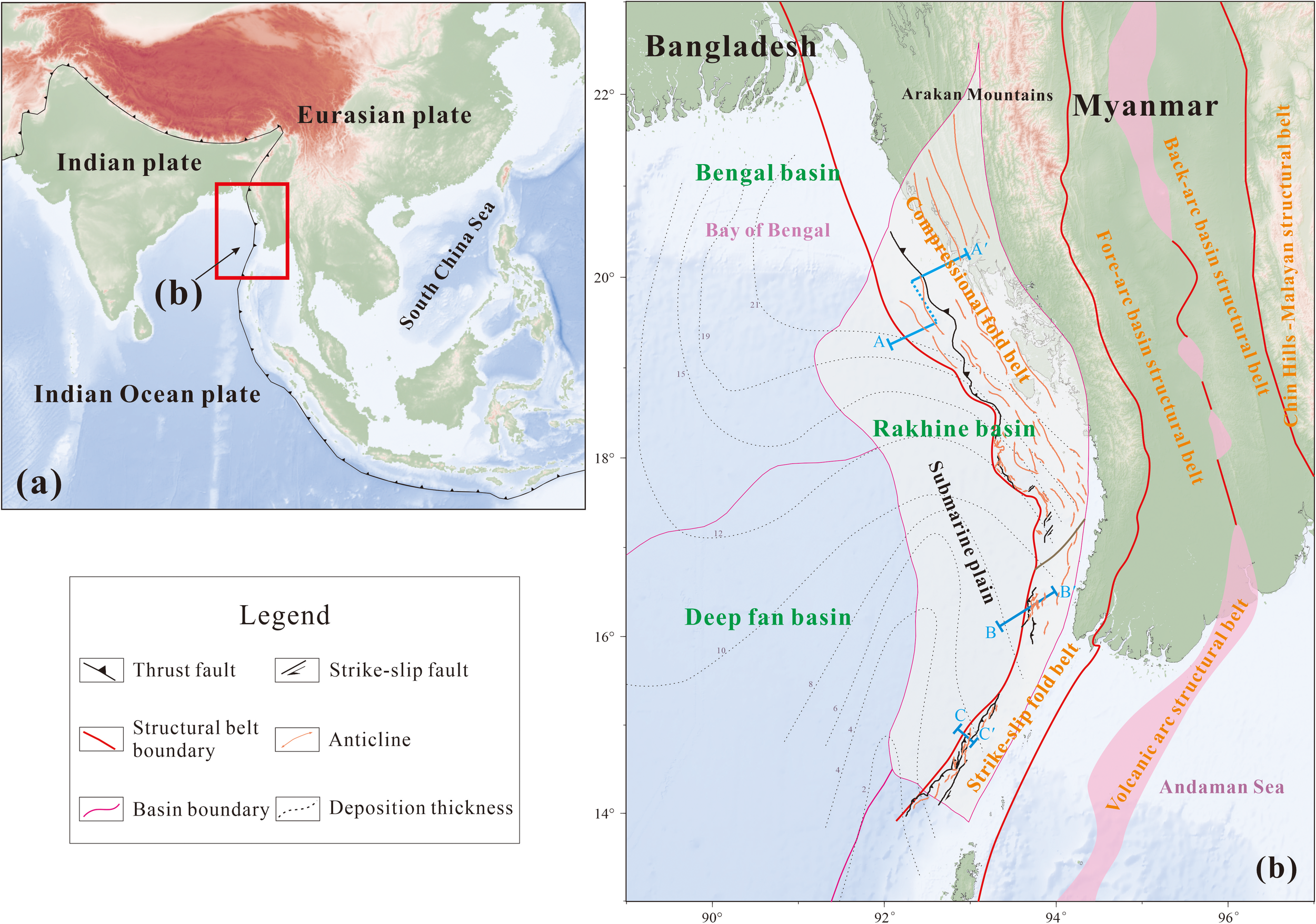
Tectonic characteristics of Rakhine Basin, Bay of Bengal, the structural belt boundaries are modified after Li et al., 2018a.
The Rakhine Basin is classified as an active continental margin basin. To the west, it borders the subduction system of the Indo-Myanmar trench, while its eastern edge is linked to the central forearc basin of Myanmar (Cai et al., 2011; Zhang et al., 2014). Recent researches on the Rakhine Basin have primarily concentrated on investigating tectonic zonation and sedimentary filling sequences, which reveal that the basement of the basin consists of fragmented, coiled ancient oceanic crust, trench deposits, and pieces of continental crust (Dasgupta and Nandy, 1995; Sikder and Alam, 2003; Steckler et al., 2008). The basin’s tectonic evolution is primarily affected by the northeastward subduction of the Indian Ocean plate. The basin has experienced several phases of tectonic compression and thrusting, leading to the development of characteristic imbricate thrust tectonic systems. The basin contains multiple sets of interactive marine and terrestrial sedimentary systems, spanning from the Eocene to the Quaternary. Notably, the Miocene deep-water turbidite exhibits considerable reservoir potential (Cai et al., 2011; Zhang et al., 2014). However, due to tectonic modifications, the depocenter have undergone regular migration. It has been observed that numerous tectonic traps are associated with thrust faults, although the reservoir’s physical properties have been significantly altered by later tectonic activities (Khin et al., 2022). A unified understanding of the Cenozoic tectonic evolution of the Rakhine basin has not yet been reached, particularly regarding the unverified transformation mechanism of the tectonic stress field since the Miocene.
Using high-precision three-dimensional seismic data and drilling data, we systematically reconstruct the Cenozoic tectonic evolution of the Rakhine basin, focusing on identifying critical tectonic modification periods and their effects on sedimentary filling. By quantifying tectonic shortening using the balanced cross-section technique and combining it with an analysis of the ancient stress field, the dynamic relationship between the variation in the subduction angle of the Indian Ocean plate and the evolution of the basin’s tectonic style is revealed. The results can offer new theoretical geological basis for petroleum exploration in foreland thrust belts.
2 Geologic setting
The active continental margin of Burma is affected by the northeastward oblique subduction of the Indian Ocean plate beneath the Burmese plate, along with the Sagaing Fault, an active strike-slip fault that exhibits a significant strike-slip displacement of 450km (He et al., 2011; Xie et al., 2010). A vast trench-arc system has developed, encompassing fore-arc basins, back-arc basins, and accretionary wedge basins (Bannert and Helmcke, 1981; Xing and Qiu, 2020). Based on its structural features, this region can be categorized into five structural units: the Rakhine fold belt including the northern compressional fold belt and the southern strike-slip fold belt, the fore-arc basin structural belt, the volcanic arc structural belt, the back-arc basin structural belt, and the Chin Hills -Malayan structural belt (Figure 1b and Figure 2e). To the east of the Rakhine fold belt lies the Arakan Mountains, while to the west is the Bay of Bengal, which represents a remnant ocean basin (Alam et al., 2003; Zhang et al., 2011), as well as a Cenozoic oceanic basin, the Andaman Sea (Kamesh and Varghese, 2004; Curray, 2005). The Rakhine fold belt spans a width of up to 230km.
Figure 2
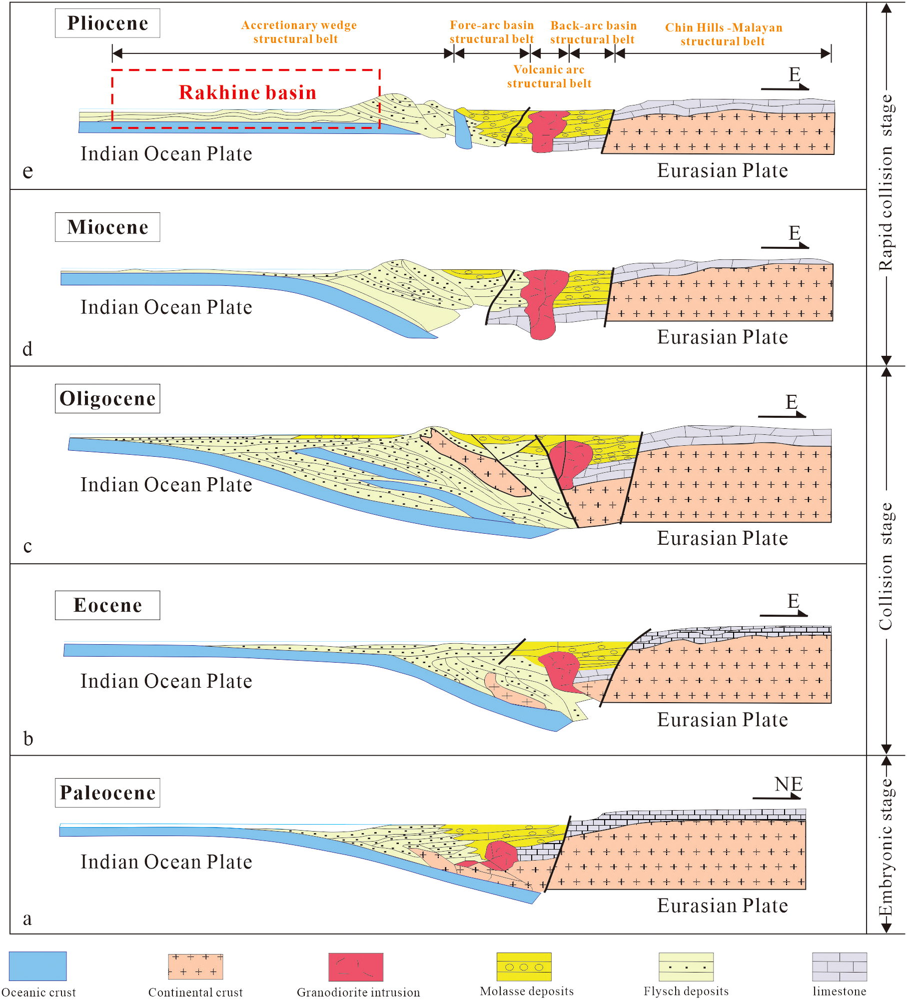
Sketch of the cross-section A-A′ through the central and western Myanmar near 20° N (modified after Bannert and Helmcke, 1981).
The interaction between the Rakhine Basin, the Bengal Basin, and the Andaman Sea constitutes a coupled system, affected by the Indo-Eurasian plate collision. The Rakhine Basin, which acts as a compressional belt within the Myanmar fore-arc, has developed a complex thrust and strike-slip structure resulting from the oblique subduction of the Indian Ocean plate (Khin et al., 2020). Meanwhile, the Bengal Basin has seen substantial sediment accumulation due to the foreland deflection. Since the Eocene, the depocenter of the basin has progressively migrated southward, driven by the subduction of the 90°E ridge. The Andaman Sea undergoes back-arc spreading as a result of the subduction retreat, with mantle upwelling playing a role in regulating the oblique angle of the subduction (Bertrand and Rangin, 2003).
The Sagaing strike-slip fault plays a crucial role in regulating the interaction between the Indian and Eurasian plates, forming a dynamic coupling with the Andaman Sea subduction zone. GPS data show that the fault exhibits dextral strike-slip movement at a rate of 18–24 mm/year (Socquet et al., 2006). The strike-slip component helps absorb the shear stress that parallels the plate boundary, a result of the oblique subduction of the Indian Ocean plate. This leads to a rotation of the stress field within the Rakhine Basin and simultaneously reduces the eastward transmission of compressive stress along the eastern margin of the Bengal Basin (Khin et al., 2021). This creates a strain gradient zone between the Irrawaddy Basin and the Arakan Mountains. Additionally, the strike-slip activity of the Sagaing fault not only mitigates strain accumulation at the frontal subduction zone but also facilitates the formation of structural traps in the Rakhine Basin through compression at the end of the fault.
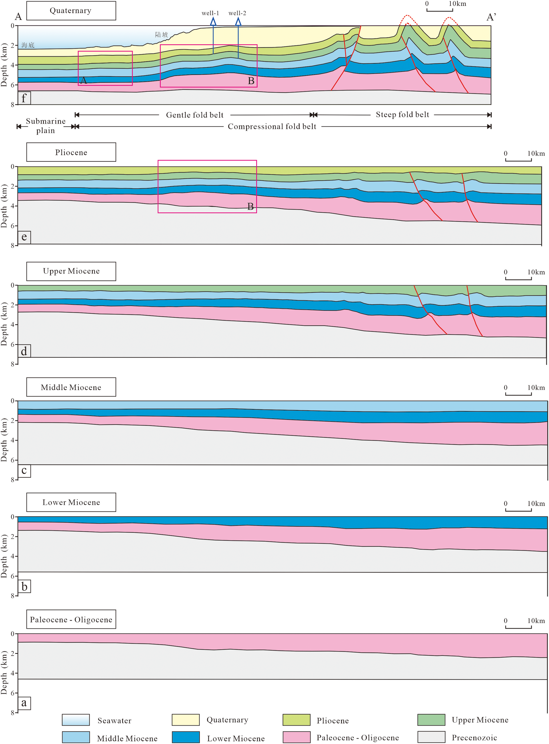
The evolution of the Rakhine Basin is intricately linked to the oblique convergence between the Indian Ocean and Burmese plates, initiating in the Paleocene, and the subsequent westward migration of the accretionary wedge (He et al., 2011; James, 1990; Ashraf and Lunberg, 2004; Cai et al., 2011). Over time, this process led to the formation of the current coastal, continental shelf, slope, and ocean floor regions of western Myanmar, located on the eastern edge of the Bay of Bengal. The present basin configuration is thought to have been established by the middle Pleistocene. Its evolution can be divided into three stages: the embryonic stage, the collision stage, and the rapid collision stage (Figure 2).
During the late Cretaceous, as the Indian Ocean plate drifted northward, the region experienced an open marine environment (Cai et al., 2011), where it received distal sediments from the Indian hinterland, and flyschoid sedimentation was dominant. A notable unconformity, which spans much of the Early Paleocene, is commonly observed throughout the region. This could mark the initiating of the active oblique subduction of the Indian Ocean plate beneath the Burmese plate, followed by the thrusting of sediments at the plate’s leading edge. By the end of the Early Paleocene, the thrusting process split the sea into two regions: the Central Myanmar Tertiary Belt to the east and a foredeep basin system to the west, both of which progressively younger from north to south (Khin et al., 2021). From this point onward, the Rakhine Basin evolved independently from the Central Burma Basin (Figure 2a). As the accretionary wedge gradually uplifted, the sea shallowed along the wedge, and the depocenter migrated westward throughout the Eocene (Khin et al., 2014), where rapid subsidence occurred (Figure 2b). By the Early Oligocene, the accretionary wedge began to emerge as the proto-Indo-Myanmar Range, initially at its northernmost tips and progressively extending southward. Towards the end of the Oligocene, the region experienced a marine regression (Khin et al., 2020; Yang et al., 2022), with parts of the region likely undergoing sub-aerial exposure and erosion (Figure 2c). This period may have marked the initiation of a high-tectonic phase, during which a transpressional regime became active in the basin (Kapp and DeCelles, 2019). With the Early Miocene transgression, flyschoid sedimentation was gradually reestablished in the central part of the basin. A significant structural phase was initiated at the end of the late Miocene, triggered by the opening of the Andaman Sea to the southeast and the activation of a major right-lateral transform fault system across the entire region (Kent and Dasgupta, 2004; Li et al., 2018a). This led to the emergence of the Arakan-Yoma Range, causing the depocenter to migrate further westward from the Arakan coastal area into the Bay of Bengal. In the Early Pliocene, a slope-floor depositional system was established immediately west of the accretionary wedge front, migrating progressively westward into the Bay of Bengal (Figure 2d). By the Early Pleistocene, much of the Arakan coastal area had emerged, and the present configuration, where the Rakhine Offshore Basin forms the eastern boundary of the Bengal Basin system, was established (Figure 2e) (Li et al., 2018b).
Wells data and outcrop observations show that the sediment gradually thins from the northeast to the southwest along the active continental margin of Burma (Curray, 1994, Curray, 2005). In the Rakhine Basin, the sediment thickness ranges up to 21km from the end of the Cretaceous to the Holocene (Figure 1). The sedimentary sequence, from the Cretaceous base to the present, can be divided into five formations: Upper Cretaceous-Paleocene, Eocene, Oligocene, Miocene, and Pliocene formations (Gani and Alam, 2003; Nielsen et al., 2004) (Figure 3). At the end of the Cretaceous, the Rakhine Basin was characterized by an open-ocean depositional environment, with marine shale being the dominant sediment type, along with some carbonates and deep-ocean fan sands. From the Paleocene to middle Miocene, deposition occurred in deep-ocean to bathyal conditions, where marine shale predominated. However, slumped deposits are present in the Paleocene formation, and deep-sea fan deposits, driven by an abundant supply of material, became common in the Upper Miocene-Pliocene formations. Slumped shale is also found in the Pliocene, and in the Quaternary, delta-shallow sea deposits were deposited due to the transition to a shallower marine environment (Banerjee et al., 2019).
Figure 3
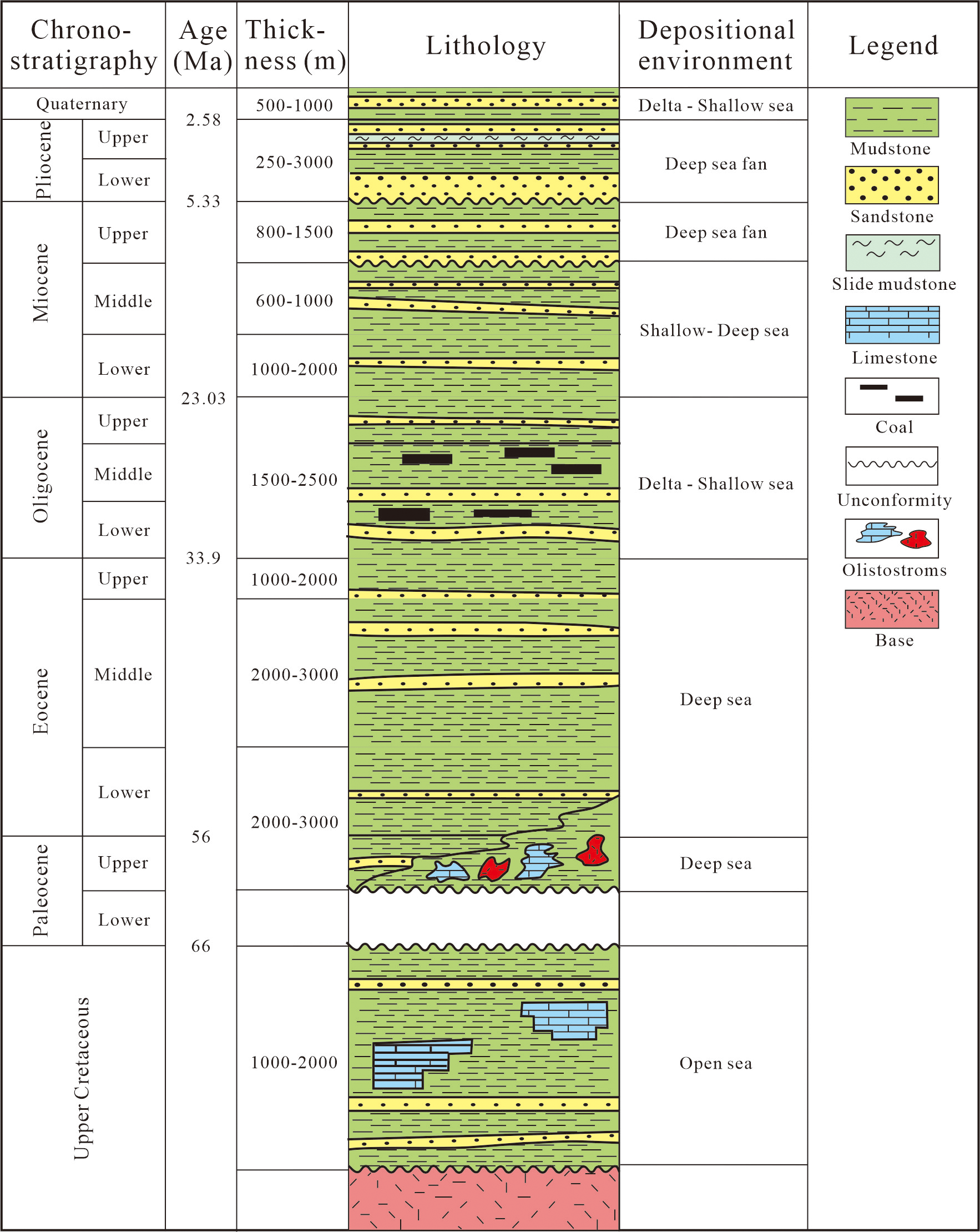
Stratigraphic column of Rakhine Basin, data are from the Information Handling Services (IHS) database.
3 Data and methods
3.1 Main data sources
The terrain data used in this study are from a marine terrain database (https://lpdaac.usgs.gov/products/srtmgl3v003/) with a precision of 1’×1’. The earthquake events are from the International Seismological Centre (http://www.isc.ac.uk/). The Stratigraphic data and drilling data are from the Information Handling Services (IHS) database (https://energyportal.ci.spglobal.com/). The 2D seismic sections A-A′ and B-B′ presented in this study are sourced from the deepwater exploration project in Myanmar of Petrochina Hangzhou Research Institute of Geology, while the section C-C′ is derived from Nielsen et al. (2004). The seismic data used is Pre-Stack Depth Migration (PSDM) data, gathered in 2008, covering depths from 0 to 14km, with exceptional quality observed in deeper layers. These data were interpreted using the seismic interpretation software GeoEast. Calibration of the seismic horizons was performed based on drilling stratigraphy.
3.2 Improved balanced cross-section method
The fault and fold structures in the Rakhine Basin, affected by multi-phase extension and strike-slip deformation, present challenges in restoring the balanced section (Westerweel et al., 2020). In response to these challenges, an improved method is utilized for restoring structural deformation in the Rakhine Basin (He and Li, 2019; Li et al., 2019). The proposed method takes into account the effects of deformation, erosion, and compaction on the restoration process, focusing on two primary aspects.
Stratum Restoration. If the deformation in the shallow structures has little effect on the deeper layers, the restoration should be performed layer by layer, maintaining the unchanged thickness of the strata. In cases where regional tectonic compression occurs in the later stages, an overall structural inversion and fold formation will occur within the basin. During the removal of each shallow stratum, the superimposed effects on the deeper layers generated during this period will be correspondingly eliminated (Yan et al., 2003; He and Li, 2019). In such cases, it is essential to follow the principle of leveling the curved strata.
Fault Restoration. For growth faults, fault restoration is to eliminate the gravity effect of the overloading. In the case of deep early growth faults, the shallow strata experience only compaction without altering their orientation (Ren et al., 2002). The restoration should follow the principle of treating the deep and shallow parts separately and independently. The method of restoring the balanced section is based on the structural positions, active stages, and genetic relationships between the strata and faults (Li et al., 2019). It aligns with geological logic and offers a more accurate inversion of the structural deformation process in the Rakhine Basin.
Decompaction Restoration. The burial history, including the stratigraphic column with age and depth data, along with lithological parameters such as sand-to-shale ratios and porosity-depth relationships, as well as paleo-water depth, were obtained from wells drilled by Petrochina. The algorithm implementation (Equation 1) utilizes an exponential porosity-depth function as follows:
where is the porosity while is the surface porosity. c is the compaction coefficient and z is the depth. The procedure for restoring the balanced section is carried out using Move software. It aligns with geological logic and offers a more accurate inversion of the structural deformation process in the Rakhine Basin.
4 Results
The Rakhine Basin can be classified into two primary sections based on whether the layers have been deformed: the eastern Rakhine fold belt and the western deep marine plain (Figure 1). In the western region, the sediment layers remain undisturbed and stable. The demarcation between the two units is marked by the deformation front, as shown by the red solid line in Figure 1 that distinguishes the deep marine plain from the fold belts (Pivnik et al., 1998).
The Rakhine fold belt exhibits an arcuate structure, extending eastward across the plane. Due to the approximately 45° angle at which the Indian Ocean plate subducts beneath the Eurasian plate in the horizontal plane, it can be further divided into the northern compressing fold belt and the southern strike-slip belt (Haproff et al., 2019). The northern compressing fold belt is characterized by numerous NNW-trending linear folds, formed by compressional stress. In contrast, the southern strike-slip belt, with its narrower NS-trending folds, results from shear stress (Maurin and Rangin, 2009).
4.1 Northern compressing fold belt of Rakhine Basin
To illustrate the deformation characteristics and zoning within the northern compressing fold belt, a regional seismic section (A-A’) was constructed using high-quality seismic profiles and well data (Figure 4a). This seismic section, spanning approximately 200km in length, is oriented perpendicular to the regional tectonic trend and combines two parallel seismic profiles separated by 60km, with its location indicated in Figure 1. The A-A’ section reveals that the base and Cretaceous formations are undeformed, while the upper Cenozoic layers are affected by deformation in the Rakhine fold belt. This suggests that the Rakhine fold belt exhibits thick-skinned deformation (Animesh et al., 2022). Furthermore, the Rakhine fold belt can be divided into two sub-structural belts based on their characteristics and locations (Maurin et al., 2010). These belts are characterized by steep, high-amplitude folds in the east and gentler, low-amplitude folds in the west, resulting from intense tectonic deformation.
Figure 4
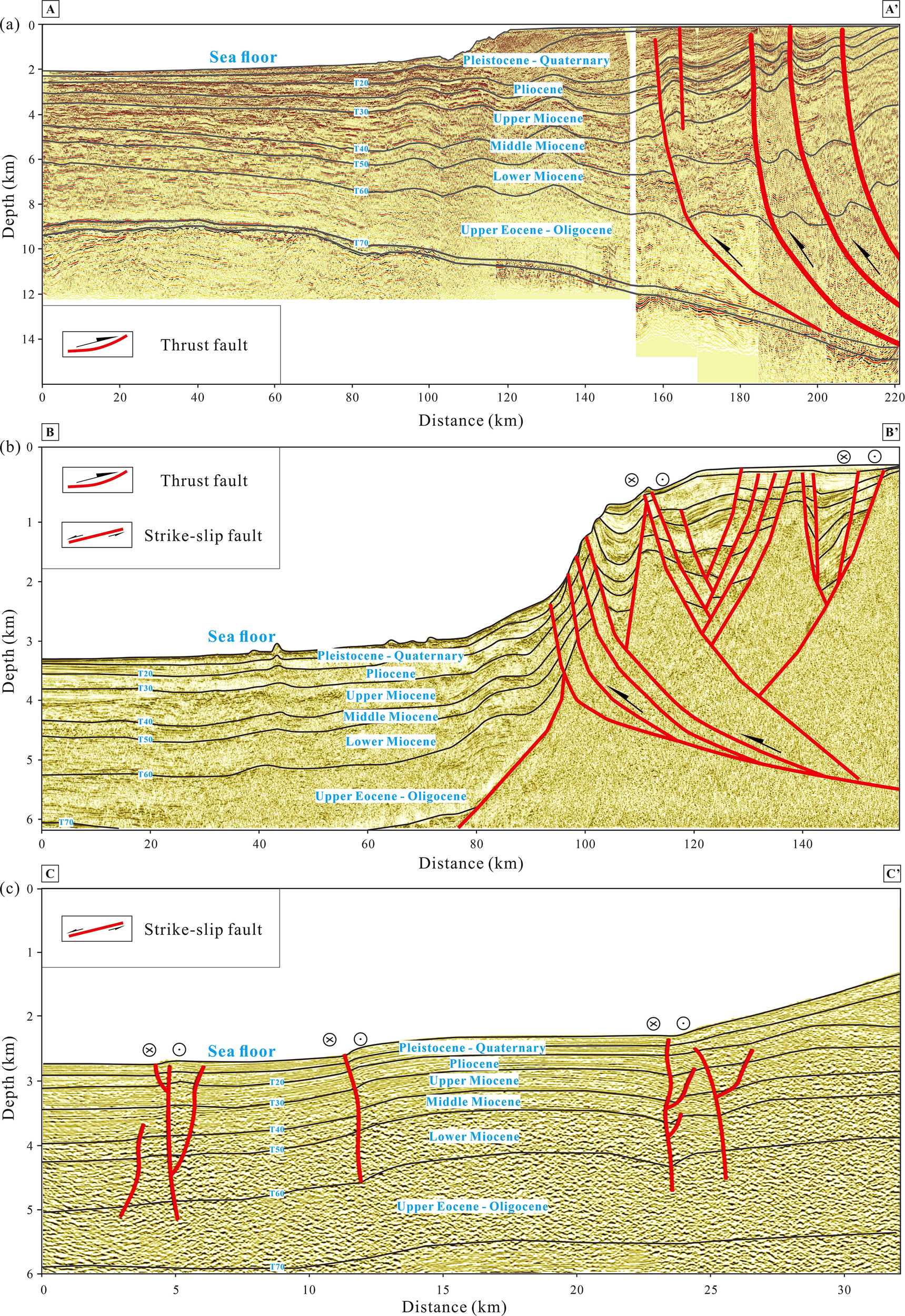
Seismic profiles across the Rakhine Basin, (a–c) are the Seismic profiles at positions A-A′, B-B′, and C-C′ from north to south.
The steep onshore folds, which formed in earlier times, consist of numerous large-scale anticlines with NNW-trending axes and significant westward amplitude. Due to intense tectonic deformation and weathering processes, Neogene formations are exposed at the cores of these anticlines (Morley, 2012). Large breakthrough faults, dipping to the east, developed in the western flanks of the anticlines, while only a few west-dipping thrust faults were observed, in response to the regional compression direction from east to west. This suggests the presence of a weak detachment layer beneath these anticlines (Replumaz, 2003). The offshore gentle, low-amplitude folds consist of two gentle, low-detachment folds (Ridd et al., 2019). The anticline in the west has a width of approximately 15km and exhibits lower amplitude compared to the anticline in the east. These folds represent the front of the deformation (Figure 4a).
4.2 Southern strike slip fold belt of Rakhine Basin
The tectonic structure of the strike-slip fold zone in the southern part of Rakhine Basin in Myanmar exhibits notable characteristics of both strike-slip and compressional coupling. The folding axis aligns closely with the regional principal stress field, and the overall orientation of the zone matches the dynamic context of the northeastward subduction of Indian Ocean plate (Ridd et al., 2019). The seismic profile reveals that the strike-slip faults in the region typically extend almost vertically, with the inclination in seismic section generally exceeding 70° (Figure 4c). Additionally, the cumulative fault amplitude can reach up to several kilometers. There is a noticeable variation in the thickness of the strata on either side of the faults. The strata of the hanging wall are generally thickened by 15%-30%, creating a broad, gentle, and low-amplitude anticline structure (Maurin and Rangin, 2009). In contrast, the thickness of the strata of the footwall remains normal, reflecting a typical differential depositional response controlled by the strike-slip fault.
The development of folds in the region is controlled by the compression and twisting effects of the right-lateral strike-slip fault. As shown in Figure 4b, it can be divided from east to west into a compressional thrust deformation belt and a gentle sedimentary belt, with the thrust faults serving as the boundary. Due to the oblique subduction, which is characterized by compressional and torsional stresses, the high and steep thrust deformation belt not only exhibits characteristics of compressional thrust structures but also displays flower structure features resulting from strike-slip stresses (Khin et al., 2021; Nielsen et al., 2004). The strike-slip faults are predominantly right-lateral. These flower-structured faults converge toward the primary faults and merge downward into the thrust faults. In the gentle sedimentary belt to the west, the strata are generally stable, presenting gently anticlines.
Compared to typical strike-slip tectonic belts, the distinct low amplitude fold-steep fault combination in the southern section of the Rakhine Basin may be affected by the blocking of the rigid base. The vertical shortening of the upper cover is restricted by the rigid base, which causes the strain to be released primarily through the strike-slip component.
5 Discussion
The primary driving force behind the tectonic zonation and varying evolution of the Rakhine Basin is the oblique subduction collision between the Indian Ocean plate and the Eurasian plate (Jagoutz et al., 2015). This interaction not only affected the development of the basin’s north-south subdivision and east-west zonation but also contributed to the early formation of the eastern fold belt with a steep structure (Haproff et al., 2019). In contrast, tectonic activity in the western fold belt persisted longer, resulting in a broader form. The mechanism for this process is intricately linked to the geometry of the subduction boundary between the plates, variations in the stress field, and the imbrication of the accretionary wedge.
5.1 Tectonic evolution of Rakhine Basin
The regional section A-A′ evolution (Figure 5) indicates that deformation initiated in the late Miocene and intensified from the late Pliocene to the Quaternary. The structures in the eastern region are both older and more deformed than those in the western area, as the regional contraction occurred from east to west, with deformation propagating in a westward direction (Royden et al., 2008). Following the deposition of Miocene formations, the center of deposition migrated from east to west (Figure 5). The sediment layers spanning from the Paleocene to the middle Miocene (Figure 5a), which show no signs of deformation, suggest that prior to the end of the middle Miocene (Figures 5b, c), subduction tectonics were located far to the east and did not affect the Rakhine Basin (Westerweel et al., 2020).
Figure 5
Tectonic evolution of cross-section A-A’ in compressive folded belt, Northern Rakhine Basin.
After the deposition of the late Miocene formations, the eastern part of the Rakhine Basin experienced slight deformation, with two east-dipping thrust faults exhibiting minimal displacement. Additionally, several low-amplitude anticlines were folded in the eastern region, while the layers to the west remained stable (Figure 5d). This suggests that the subduction began to affect the Rakhine Basin (Yao et al., 2017; Zhang et al., 2017a). During the deposition of the Pliocene formations, tectonic activity significantly affected the Rakhine Basin. The anticlines in the eastern part steepened, and new anticlines formed in the central region of the basin, with Cenozoic strata acting as a detachment layer (Figure 5e). The Pliocene formation displayed characteristics of growth strata, with the thickness becoming progressively thinner towards the tops of the eastern anticlines and anticline B.
Following the deposition of the Pliocene formation, the research area experienced the most intense compression. The eastern anticlines became significantly steeper with higher amplitudes, eventually being exposed above the water and undergoing weathering (Zhang et al., 2017b). Deformation of the anticlines in the central part of the Rakhine Basin intensified. For instance, the amplitude of anticline B increased by as much as 0.7 s, and a new, gentle, low-amplitude fold developed in the west (Figure 5f).
Additionally, regional tectonic activity from subduction caused the sediment center to migrate from east to west. During the Paleocene to Midde Miocene, the sediment center remained in the eastern part of the Rakhine Basin, as the subduction trench represented the deepest area, and the regional seafloor sloped eastward or was bent by the effects of subduction. The thickness of the Pliocene deposition remained relatively consistent, except in areas affected by folding. This indicates that the Pliocene represented a period of stability in the migration of the depocenter. By the Holocene, the depocenter had fully migrated to the west (Li et al., 2018b).
5.2 The north-south tectonic segmentation affected by subduction boundary geometry
A prominent arc-shaped boundary along Myanmar and its periphery has been developed due to the location of the Rakhine Basin at the forefront of the oblique subduction zone where the Indian Ocean plate converges with the Eurasian plate (Li et al., 2018c). In the southern section of the subduction zone, the boundary is nearly aligned north-south, with the Indian Ocean plate converging obliquely towards the Eurasian plate in a NNE direction. The subduction is almost parallel to the strike of the fault with an angle of less than 30° (Figure6, C-C’ section). This geometric configuration results in the formation of significant deep strike-slip faults along the plate boundaries, affecting by compressional and torsional stress fields (Rao and Kumar, 1999). Shear stress causes sediment layers to experience cross slip and vertical uplift, creating a wide and gently inclined anticline structure. The fold axis primarily follows a NW-SE trend, with the fault system exhibiting both strike-slip and thrust components, resulting in a representative southern strike-slip fold belt (Zhang et al., 2017b). Nicholas et al. (2016) indicated that the fold belt in the southern Arakan Mountains can reach a width of 80–100 km, with fold flanks typically having an inclination of less than 30°, reflecting progressive deformation under the shear stress.
As a result of the northward deviation of the plate boundary in the northern subduction zone, the angle between the subduction direction and the trend of the Indian Ocean plate boundary increases considerably, exceeding 60° (Figure 6, A-A’ section). At this stage, the vertical component of plate convergence becomes more pronounced, and the stress field shifts from a combination of compression and torsion to a state of pure compression (McCaffrey, 1992). The crustal materials undergo shortening along the direction of least resistance, resulting in significant NE-SW compressive deformation of the sedimentary layers, which leads to the formation of tightly packed thrust faults and a high-angle fold belt (McClay et al, 2004) ; Bertrand and Rangin (2003) demonstrated that in the fore-arc basin structural belt (Figure 1), the fold axis predominantly trends NE, with the dip angle of the anticlinal flanks reaching 40-50°. Additionally, a locally developed imbricated thrust structure contributes to the formation of the northern compressive fold belt. The contrasting tectonic patterns between the northern and southern regions are primarily affected by the spatial and temporal variations in the subduction directions and the subduction boundary angles.
Figure 6
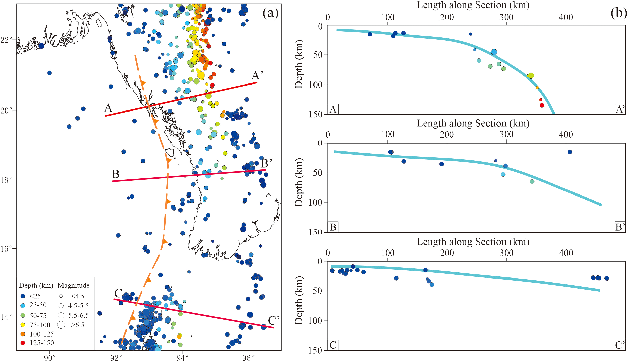
(a) Distribution of earthquake events (2000.1.1–2025.12.31); The red solid lines in part a are the cross sections of the vertical profiles of epicenters shown in part b (b) Vertical profiles of epicenters sliced at positions A-A′, B-B′, and C-C′; the green dashed lines are the sketched position of the subduction zone in the Rakhine Basin.
5.3 Variant tectonic evolution of east-west zonation affected by accretionary wedge
As an accretionary wedge basin in an oceanic-continental subduction zone, the tectonic evolution of the Rakhine Basin is marked by a pattern of “earlier in the east and later in the west.” As an early subduction front, the eastern region has experienced compression from the Indian Ocean plate since the Miocene. The fold structures formed in the early stages have been reworked by subsequent superimposed stresses (Nielsen et al., 2004; Sikder and Alam, 2003). Several tectonic events contributed to the progressive deformation of the strata. The early NW-SE folding was later reversed by NE-SW compressive forces, causing the fold axis to tilt westward. As a result of continuous uplift, the eastern fold flank developed a steep shape with a high dip angle (Raju et al., 2004). Seismic profiles reveal the development of a duplex in the deeper part of the eastern fold belt, while shallow layers are cut by thrust faults, indicating the cumulative effects of multi-stage extrusion (Figure 7). The tectonic evolutionary feature is very similar to that of the nearby Chittagong-Tripura fold belt. Previous studies (Animesh et al., 2022; Nandy et al., 1983) have shown that the Chittagong-Tripura fold belt has evolved within a compressive stress field generated by the eastward drift of the Indian Ocean plate during late Tertiary. The style of folding and outcrop pattern in the region, show that there was minor rotation of the stress axes which in turn corroborates rotation of the Indian Ocean plate during late Tertiary while it drifted eastward. The deformation of the sedimentary units was first initiated by tangential E-W compressive stress resulting in shortening, principally by folding and strike faulting and adjustment along conjugate shear fractures with strike slip movements.
Figure 7
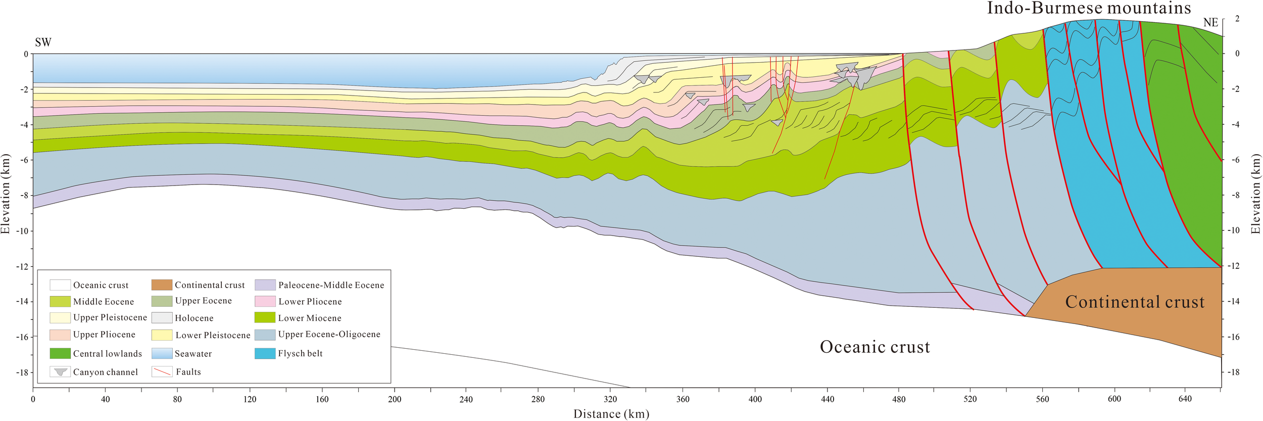
Schematic profile of east-west structural zonation affected by accretionary wedge (the location is at the at position A-A′).
The western region lies in the late accretionary stage of the accretionary wedge, with tectonic activity beginning relatively later (from the Pliocene to the present). Due to the westward migration of the subduction zone front, broad and gently sloping anticlines are primarily developed in this area (Ashraf and Lunberg, 2004). The dip angle of the fold axis is generally less than 25°, and the shortening of the strata is approximately 40% lower than that in the eastern part (Figure 7). Additionally, the broad and gentle structures in the western region are more favorable for the preservation of oil and gas traps (James, 1990).
5.4 Dynamic effect of oblique subduction
The nature of oblique subduction is that the plate convergence vector is not orthogonal to the trend of the subduction zone, resulting in the strain field being resolved into a strike-slip component along the parallel boundary and a compressional component along the vertical boundary (Vanek et al., 1990). In the Rakhine Basin, this decomposition occurs through bookshelf faulting. The Sagaing faults serve as the primary strike-slip boundary to accommodate lateral displacement, while secondary thrust faults mediate vertical shortening (Figure 8). GPS data indicate that the dextral strike-slip rate along the Sagaing faults is 18–23 mm/yr, while the vertical uplift rate of the Arakan Mountains is approximately 5 mm/yr, thereby confirming the spatial distribution of strain components (Socquet et al., 2006). The numerical simulation results (Vigny et al., 2003; Zahid and Uddin, 2005) indicate that when the angle between the convergence direction and the subduction boundary is less than 45°, the strike-slip component accounts for over 70% (Figure 8), which closely aligns with the deformation characteristics of the southern tectonic belt.
Figure 8
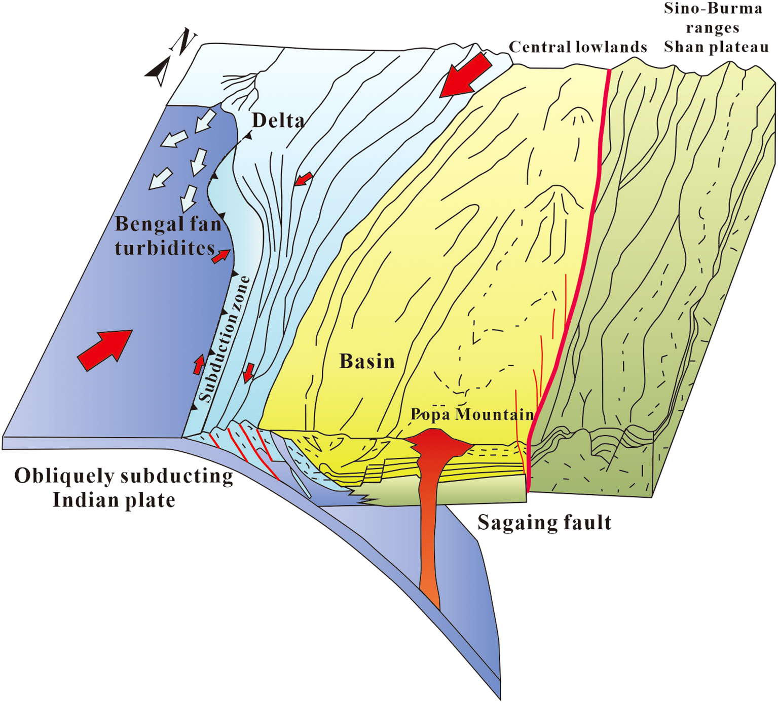
Regional tectonic model of the eastern Bay of Bengal (modified after Pivnik et al., 1998).
The tectonic model plays a crucial role in controlling oil and gas accumulation. Although the eastern high-steep tectonic belt formed earlier, its trap integrity is poor due to later intense compression. In contrast, the western broad-mild anticline is more favorable for the development of large structural traps due to its weaker deformation (Rabi et al., 2010). Additionally, the coupling effect of strike-slip and compression forms a complex fault-fold transport system within the basin, which governs the vertical migration and lateral distribution of oil and gas. This understanding provides a crucial geological basis for petroleum exploration in the Rakhine basin.
6 Conclusions
The Rakhine basin is situated in an accretionary wedge within the trench setting of an active continental margin. The basin can be divided into two main regions: the marine plain and the Rakhine fold belt. The Rakhine fold belt itself consists of the northern compressing fold belt and the southern strike-slip belt. The northern compressing fold belt is characterized by numerous NNW-trending linear folds, which can be further subdivided into steep, high-amplitude folds resulting from intense tectonic deformation from east to west. The southern strike-slip belt, on the other hand, features anticlines along strike-slip faults and distinct flower structures.
The deformation of Rakhine basin initiated in the late Miocene and intensified from the late Pliocene to the Quaternary. Structures in the eastern part are older and more intense than those in the western part, as regional contraction occurred from east to west, with deformation propagating westward. The depocenter also migrated from east to west following the deposition of Miocene formations.
The tectonic characteristics of the Rakhine Basin are marked by north-south segmentation and east-west zonation, with the warped plate of the depocenter rotating counterclockwise to the west. This is primarily caused by the oblique subduction collision between the Indian Ocean plate and the Eurasian plate, the bends in the subduction contact zone within the Rakhine Basin, the differing subduction angles between the north and south, and the contrasting stress field mechanisms between the two sections.
Statements
Data availability statement
The original contributions presented in the study are included in the article/supplementary material. Further inquiries can be directed to the corresponding author/s.
Author contributions
XW: Writing – original draft, Formal Analysis, Writing – review & editing, Conceptualization. GF: Writing – original draft, Conceptualization, Writing – review & editing. HW: Writing – review & editing, Supervision. GZF: Writing – review & editing, Validation. GZ: Writing – review & editing, Methodology. XX: Writing – review & editing, Investigation. ZY: Writing – review & editing, Investigation.
Funding
The author(s) declare financial support was received for the research and/or publication of this article. This research was funded by the National Science and Technology Major Project of China (No. 2024ZD1402705), the Petrochina Basic and Frontier Science and Technology Project (No. 2024ZZ5601) the National Natural Science Foundation of China (Grant Nos. 42276072). Petrochina was not involved in the study design, collection, analysis, interpretation of data, the writing of this article, or the decision to submit it for publication.
Conflict of interest
All authors were employed by Petrochina Hangzhou Research Institute of Geology.
Generative AI statement
The author(s) declare that no Generative AI was used in the creation of this manuscript.
Any alternative text (alt text) provided alongside figures in this article has been generated by Frontiers with the support of artificial intelligence and reasonable efforts have been made to ensure accuracy, including review by the authors wherever possible. If you identify any issues, please contact us.
Publisher’s note
All claims expressed in this article are solely those of the authors and do not necessarily represent those of their affiliated organizations, or those of the publisher, the editors and the reviewers. Any product that may be evaluated in this article, or claim that may be made by its manufacturer, is not guaranteed or endorsed by the publisher.
References
1
Aitchison J. C. Ao A. Bhowmik S. Clarke G. L. Ireland T. R. Kachovich S. et al . (2019). Tectonic evolution of the western margin of the Burma microplate based on new fossil and radiometric age constraints. Tectonics38, 1718–1741. doi: 10.1029/2018TC005049
2
Alam M. Alam M. M. Curray J. R. Chowdhury M. L.R. Gani M. R. (2003). An overview of the sedimentary geology of the Bengal Basin in relation to the regional tectonic framework and basin-fill history. Sedimentary Geol.155, 179–208.
3
Animesh D. Santanu B. Sujit D. Sreetama R. Basab M . (2022). Post-Oligocene evolution of Indo-Burma wedge: Insights from deformation structures of Tripura Mizoram fold belt. J. Struct. Geology154, 104497. doi: 10.1016/j.jsg.2021.104497
4
Ashraf U. Lunberg N. (2004). Miocene sedimentation and subsidence during continent-continent collision, Bengal basin, Bangladesh. Sedimentary Geology164, 131–135. doi: 10.1016/j.sedgeo.2003.09.004
5
Barnita B. Ahmad S. M. Babu E. V. S. S. K. Padmakumari V. M. Beja S. K. Satyanarayanan M. et al . (2019). Geochemistry and isotopic study of southern Bay of Bengal sediments: Implications for provenance and paleoenvironment during the middle Miocene. Palaeogeography Palaeoclimatology Palaeoecol.514, 156–167. doi: 10.1016/j.palaeo.2018.10.022
6
Bannert D. Helmcke D. (1981). The evolution of the Asian plate in Burma. Geologische Rundsehau70, 448–458. doi: 10.1007/BF01822125
7
Bertrand G. Rangin C. (2003). Tectonics of the western margin of the Shan plateau (central Burma): Implication for the India-IndoChina oblique convergence since Oligocene. J. Asian Earth Sci.10, 1139–1157. doi: 10.1016/S1367-9120(02)00183-9
8
Cai W. J. Zhu G. H. Jiang Y. Yang S. L. Li A. S. Xie N. et al . (2011). Structural features and exploration prospect of subduction accretionary belt in Myanmar. Natural Gas Geosci.4670–673. doi: 10.11764/j.issn.1672-1926.2011.04.670
9
Curray J. R. (1994). Sediment volume and mass beneath the Bay of Bengal. Earth Planetary Sci. Lett.125, 371–383. doi: 10.1016/0012-821X(94)90227-5
10
Curray J. R. (2005). Tectonics and history of the Andaman sea region. J. Asian Earth Sci.25, 187–232. doi: 10.1016/j.jseaes.2004.09.001
11
Dasgupta S. Nandy D. R. (1995). Geological framework of the Indo-Burmese convergent margin with special reference to ophiolite emplacement. Indian J. Geology67, 110–125.
12
Gani M. R. Alam M. M. (2003). Sedimentation and basin-fill history of the Neogene clastic succession exposed in the southeastern fold belt of the Bengal Basin, Bangladesh: a high-resolution sequence stratigraphic approach. . Sedimentary Geology155, 227–270. doi: 10.1016/S0037-0738(02)00182-3
13
Haproff P. Zuza A. Yin A. Harrison T. Manning C. Dubey C. et al . (2019). Geologic framework of the northern Indo-Burma Ranges and lateral correlation of Himalayan-Tibetan lithologic units across the eastern Himalayan syntaxis. Geosphere15, 856–881. doi: 10.1130/GES02054.1
14
He W. G. Mei L. F. Zhu G. H. Ynag S. L. Hu Z. W. Xiao S. G. et al . (2011). Study on tectonic and evolution characteristics of basins in Andaman Sea. Fault-Block Oil Gas Field18, 178–182.
15
He X. Y. Li L. (2019). Method for restoring balanced evolution profile in complex extensional basin area. Chin. J. Geology54, 1210–1222. doi: 10.12017/dzkx.2019.068
16
Jagoutz O. Royden L. Holt A. F. et al . (2015). Anomalously fast convergence of India and Eurasia caused by double subduction. Nat. Geosci.8, 475–478. doi: 10.1038/ngeo2418
17
James R.C. (1990). Himalayan uplift, sea level and the record of Bengal fan sedimentation at the ODP Leg 116 sitesroceeding ocean drilling program Sci. Results116, 397–414.
18
Kamesh K. A. Varghese J. (2004). New insight into the tectonic evolution of the Andaman Basin, northeast Indian Ocean. Earth Planetary Sci. Lett.221, 145–162. doi: 10.1016/S0012-821X(04)00075-5
19
Kapp P. DeCelles P. G. (2019). Mesozoic-Cenozoic geological evolution of the Himalayan-Tibetan orogen and working tectonic hypotheses. Am. J. Sci.319, 159–254. doi: 10.2475/03.2019.01
20
Kent N. W. Dasgupta U. (2004). Structural evolution in response to fold and thrust belt tectonics in northern Assam: A key to hydrocarbon exploration in the Jaipur anticline area. Mar. Petroleum Geology21, 785–803. doi: 10.1016/j.marpetgeo.2003.12.006
21
Khin K. Moe A. Kyi P. (2022). Tectono-structural framework of the Indo-Myanmar Ranges: Implications for the structural development on the geology of the Rakhine coastal Region, Myanmar. Geosystems Geoenvironment3, 100079. doi: 10.1016/j.geogeo.2022.100079
22
Khin K. Moe A. Myint M. (2020). Geology, structure and lithostratigraphic framework of the Rakhine Coastal Ranges in western Myanmar: Implications for the collision of the India Plate and West Myanmar Block. J. Asian Earth Sci.196, 104332. doi: 10.1016/j.jseaes.2020.104332
23
Khin K. Moe A. Myint M. et al . (2021). Dextral transpressional shearing and strike-slip partitioning developments in the Central Myanmar Basin during the collision between the India Plate and West Myanmar Block. J. Asian Earth Sci.5, 100055. doi: 10.1016/j.jaesx.2021.100055
24
Khin K. Sakai T. Zaw K. (2014). Neogene syn-tectonic sedimentation in the eastern margin of Arakan-Bengal basins, and its implications on for the Indian-Asian collision in western Myanmar. Gondwana Res.26, 89–111. doi: 10.1016/j.gr.2013.04.012
25
Li W. Guo T. T. Wu Z. P. Xu C. G. Wu K. Chen X. P. et al . (2019). Application of balanced cross-section method in extension, strike-slip superposition and ratio analysis: A case study of Liaodong Bay depression, Bohai Bay Basin. Geological Rev.65, 1501–1514. doi: 10.16509/j.georeview.2019.06.015
26
Li R. Y. Mei L. F. Hu X. L. et al . (2018b). Fission track thermochronological evidence for cenozoic uplift of northern central Myanmar basin. Earth. Science43, 1931–1940. doi: 10.3799/dqkx.2018.510
27
Li R. Y. Mei L. F. Hu X. L. et al . (2018c). Reconstructions of the Cenozoic paleogeomorphology of the north of Central Myanmar Basin. Bull. Geological Sci. Technol.27, 126–133. doi: 10.19509/j.cnki.dzkq.2018.0317
28
Li J. X. Zhang L. Y. Fan W. M. Ding L. Sun Y. L. Peng T. P. et al . (2018a). Mesozoic-Cenozoic tectonic evolution and metallogeny in Myanmar: Evidence from zircon/cassiterite U-Pb and molybdenite Re-Os geochronology. Ore Geology Rev.102, 829–842. doi: 10.1016/j.oregeorev.2018.10.009
29
Maurin T. Masson F. Rangin C. (2010). et al, First global positioning system results in northern Myanmar: Constant and localized slip rate along the Sagaing fault. Geology38, 591–594. doi: 10.1130/G30872.1
30
Maurin T. Rangin C. (2009). Structure and kinematics of the Indo-Burmese wedge: recent and fast growth of the outer wedge. Tectonics28. doi: 10.1029/2008TC002276
31
McCaffrey R. (1992). Oblique plate convergence, slip vectors, and forearc deformation. J. Geophysical Res.97, 8905–8915. doi: 10.1029/92JB00483
32
McClay K. R. Whitehouse P. S. Dooley T. et al . (2004). 3D evolution of fold and thrust belts formed by oblique convergence. Mar. Petroleum Geology21, 857–877. doi: 10.1016/j.marpetgeo.2004.03.009
33
Morley C. K. (2012). Late Cretaceous-Early Palaeogene tectonic development of SE Asia. Earth-Science Rev.115, 37–75. doi: 10.1016/j.earscirev.2012.08.002
34
Nandy D. R. Dasgupta S. Kalyan S. Ganguly A . (1983). Tectonic evolution of Tripura-Mizoram fold belt, Surma basin, northeast India. J. Geological Soc. India55, 186–194.
35
Nicholas J. G. Laurence J. R. Christopher K. M. Michael P. S. Peter A. C. Martin J. W. et al . (2016). The tectonic and metallogenic framework of Myanmar: A Tethyan mineral system. Ore Geology Rev.79, 26–45. doi: 10.1016/j.oregeorev.2016.04.024
36
Nielsen C. Chamot-Rooke N. Rangin C. the ANDAMAN Cruise Team 2 . (2004). From partial to full strain partitioning along the Indo-Burmese hyper-oblique subduction. Mar. Geology209, 303–327. doi: 10.1016/j.margeo.2004.05.001
37
Pivnik D. A. Nahm J. Tucker R. S. (1998). Polyphase deformation in a fore-arc/back-arc basin, Salin Subbasin, Myanmar (Burma). AAPG Bull.82, 1837–1856.
38
Rabi B. Suman D. Radhakrishna M. (2010). Pre- and post-collisional depositional history in the upper and middle Bengal fan and evaluation of deepwater reservoir potential along the northeast Continental Margin of India. Mar. Petroleum Geology27, 2051–2061. doi: 10.1016/j.marpetgeo.2010.04.007
39
Raju K. A. K. Ramprasad T. Rao P. S. et al . (2004). NE-W insights into the tectonic evolution of the Andaman basin, northeast Indian Ocean. Earth Planetary Sci. Lett.221, 145–162. doi: 10.1016/S0012-821X(04)00075-5
40
Rao N. P. Kumar (1999). Evidences for cessation of India Plate subduction in the Burmese arc region. Geophysical Res. Lett.26, 3149–3152. doi: 10.1029/1999GL005396
41
Ren J. Tamaki K. Li S. et al . (2002). Late Mesozoic and Cenozoic rifting and its dynamic setting in eastern China and adjacent areas. Tectonophysics344, 175–205. doi: 10.1016/S0040-1951(01)00271-2
42
Replumaz A. (2003). Tapponnier, Reconstruction of the deformed collision zone Between India and Asia by backward motion of lithospheric blocks. J. Geophysical Research: Solid Earth108, 62285. doi: 10.1029/2001JB000661
43
Ridd M. F. Crow M. J. Morley C. K. (2019). The role of strike-slip faulting in the history of the Hukawng Block and the Jade Mines Uplift. Proc. Geologists Assoc.130, 126–141. doi: 10.1016/j.pgeola.2019.01.002
44
Royden L. H. Burchfiel B. C. van der Hilst R. D. (2008). The geological evolution of the Tibetan Plateau. Science321, 1054–1058. doi: 10.1126/science.1155371
45
Sikder A. M. Alam M. M. (2003). 2-D modelling of the anticlinal structures and structural development of the eastern fold belt of the Bengal Basin, Bangladesh. Sedimentary Geology155, 209–226. doi: 10.1016/S0037-0738(02)00181-1
46
Socquet A. Vigny C. Chamot-Rooke N. Simons W. Rangin C. Ambrosius B. et al . (2006). India and Sunda plates motion and deformation along their boundary in Burma determined by GPS. J. Geophysical Res.111, B05406. doi: 10.1029/2005JB003877
47
Steckler M. S. Akhter S. H. Seeber L. (2008). Collision of the Ganges-Brahmaputra Delta with the Burma Arc: Implications for earthquake hazard. Earth Planetary Sci. Lett.273, 367–378. doi: 10.1016/j.epsl.2008.07.009
48
Vanek J. Hanus V. Sitaram M. V. D. (1990). Seismicity and deep structure of the Indo-Burman plate margin. J. Southeast Asian Earth Sci.4, 147–157. doi: 10.1016/0743-9547(90)90014-5
49
Vigny C. Socquet A. Rangin C. Chamot-Rooke N. Pubellier M. Bouin M. N. et al . (2003). Present-day crustal deformation around Sagaing fault, Myanmar. J. Geophysical Res108. doi: 10.1029/2002JB001999
50
Westerweel J. Licht A. Cogné N. Roperch P. Dupont-Nivet G. Thi M. K. et al . (2020). Burma terrane collision and northward indentation in the eastern himalayas recorded in the eocene miocene chindwin basin (Myanmar). Tectonics39, e2020TC006413. doi: 10.1029/2020TC006413
51
Xie N. Jiang Y. Shu G. H. Yang S. L. Li A. S. (2010). Evolution of the sagaing strike-slip fault and its control of Shwebo Basin structural evolution, Myanmar. Geoscience24, 288–272.
52
Xing L. D. Qiu L. (2020). Zircon U-Pb age constraints on the mid-Cretaceous Hkamti amber biota in northern Myanmar. Palaeogeography Palaeoclimatology Palaeoecol.558, 109960. doi: 10.1016/j.palaeo.2020.109960
53
Yan D. P. Tian C. L. Meng L. B. et al . (2003). Balanced geological section for extensional tectonic basin and its implication: an example from southern Songliao Basin. Earth Sci.3, 275–280.
54
Yang Z. Y. Bi X. W. Zhu J. J. Hu R. Z. Zhong H. Sein K. et al . (2022). Mid-Cretaceous intra-oceanic arc-continent collision recorded by the igneous complex in central Myanmar. Lithos414, 106637. doi: 10.1016/j.lithos.2022.106637
55
Yao W. Ding L. Cai F. L. Wang H. Q. Qiang X. Than Z. et al . (2017). Origin and tectonic evolution of upper Triassic Turbidites in the Indo-Burman ranges, West Myanmar. Tectonophysics721, 90–105. doi: 10.1016/j.tecto.2017.09.016
56
Zahid K. M. Uddin A. (2005). Influence of overpressure on formation velocity evaluation of Neogene strata from the eastern Bengal Basin. Bangladesh J. Asian Earth Sci.25, 419–429. doi: 10.1016/j.jseaes.2004.04.003
57
Zhang S. Y. Ma L. X. Mei L. F. et al . (2011). Cenozoic sediment provenance analysis and sedimentary system distribution in Myanmar and its bordering areas. Geological Sci. Technol. Inf.30, 29–35.
58
Zhang P. Mei L. F. Hu X. L. Li R. Y. Wu L. L. Zhou Z. C. et al . (2017b). Structures, uplift, and magmatism of the Western Myanmar Arc: Constraints to mid Cretaceous–Paleogene tectonic evolution of the western Myanmar continental margin. Gondwana Res.52, 18–38. doi: 10.1016/j.gr.2017.09.002
59
Zhang P. Mei L. F. Ma Y. et al . (2014). Tectonic features and dynamic evolution of Bay of Bengal Basin: new insights into satellite-gravity and seismic data. Earth Sci.39, 1307–1321. doi: 10.3799/dqkx.2014.123
60
Zhang J. E. Xiao W. J. Windley B. F. Cai F. L. Sein K. Naing S. et al . (2017a). Early Cretaceous wedge extrusion in the Indo-Burma Range accretionary complex: Implications for the Mesozoic subduction of Neotethys in SE Asia. Int. J. Earth Sci.106, 1391–1408. doi: 10.1007/s00531-017-1468-7
Summary
Keywords
Rakhine Offshore Basin, compressional fold belt, strike-slip fold belt, stress field, oblique subduction
Citation
Wang X, Fang G, Wang H, Fan G, Zuo G, Xu X and Yang Z (2025) The dynamic mechanism of north-south tectonic disparities in the Rakhine Offshore Basin of Myanmar. Front. Mar. Sci. 12:1633707. doi: 10.3389/fmars.2025.1633707
Received
23 May 2025
Accepted
18 August 2025
Published
02 September 2025
Volume
12 - 2025
Edited by
Liang Qiu, China University of Geosciences, China
Reviewed by
Xiwu Luan, Shandong University of Science and Technology, China
Rumana Yeasmin, Jahangirnagar University, Bangladesh
Updates
Copyright
© 2025 Wang, Fang, Wang, Fan, Zuo, Xu and Yang.
This is an open-access article distributed under the terms of the Creative Commons Attribution License (CC BY). The use, distribution or reproduction in other forums is permitted, provided the original author(s) and the copyright owner(s) are credited and that the original publication in this journal is cited, in accordance with accepted academic practice. No use, distribution or reproduction is permitted which does not comply with these terms.
*Correspondence: Gui Fang, fangg_hz@petrochina.com.cn
Disclaimer
All claims expressed in this article are solely those of the authors and do not necessarily represent those of their affiliated organizations, or those of the publisher, the editors and the reviewers. Any product that may be evaluated in this article or claim that may be made by its manufacturer is not guaranteed or endorsed by the publisher.