 Taner Yildiz1*
 Nurdan Cömert1
 Carmen Ferrà2,3,4
 Uygar Şaşmaz5
 Alessandro Galdelli3,6
 Anna Nora Tassetti2,3
- 1Department of Fisheries Technology and Management, Faculty of Aquatic Sciences, Istanbul University, Istanbul, Türkiye
- 2National Research Council, Institute for Biological Resources and Marine Biotechnologies, Ancona, Italy
- 3National Biodiversity Future Center, Palermo, Italy
- 4Department of Biological, Geological and Environmental Sciences (BiGeA), University of Bologna, Bologna, Italy
- 5Department of Computer Engineering, Faculty of Engineering and Natural Sciences, Biruni University, İstanbul, Türkiye
- 6Department of Information Engineering, Università Politecnica delle Marche, Ancona, Italy
This study investigates the spatial, temporal, environmental, and behavioral drivers of Automatic Identification System (AIS) signal gaps in trawl fishing vessels operating in the Black Sea. AIS deliberate or accidental signal gaps, which may cause vessels to become temporarily invisible to AIS-based surveillance systems, hinder maritime monitoring, compliance enforcement, and fisheries management — even though such vessels may still be detectable via alternative systems such as VMS. The analysis focused on two primary trawl types; bottom and pelagic trawl. Using a comprehensive dataset of AIS signals, environmental variables and vessel activity, the study integrated spatial and temporal analyses with XGBoost machine learning technique to identify key predictors of AIS gaps. The results reveal distinct seasonal and spatial patterns in AIS gap behavior, with significant variation between trawl types. For bottom trawls, AIS gaps were concentrated near the northern entrance of the Istanbul Strait, while pelagic trawls exhibited broader distributions along the Black Sea coast, particularly near Zonguldak and Samsun. Machine learning model demonstrated strong predictive performance, with an accuracy of 80.26%, AUC of 0.8855, TSS of 0.6052, MAE of 1336.74 minutes, and RMSE of 3205.54 minutes for bottom trawls. For pelagic trawls, the model achieved 61.68% accuracy, an AUC of 0.6663, TSS of 0.2336, MAE of 2011.05 minutes, and RMSE of 4400.40 minutes, indicating moderate predictive capabilities. Key predictors included environmental factors such as chlorophyll concentration and sea surface temperature, alongside spatial metrics like depth and proximity to shore and port. Partial dependence plots highlighted the non-linear effects of these variables, with chlorophyll concentration showing a critical threshold around 3.5 mg/m³ and sea surface temperature influencing gaps most significantly at approximately 15°C. This study provides the first systematic analysis of AIS gaps in Black Sea fisheries, contributing valuable insights into their drivers and implications for fisheries management. By identifying high-risk zones and temporal patterns, the findings could support improved monitoring strategies, regulatory enforcement, and sustainable resource use in this ecologically significant region.
Introduction
Marine ecosystems play a vital role in global biodiversity and food security (Jefferson et al., 2022), yet they face increasing pressures from overfishing and illegal activities (Agnew et al., 2009; Sumaila and Tai, 2020). Effective monitoring and management of fishing activities are therefore essential to ensure the sustainability of these ecosystems. Automatic Identification Systems (AIS), which are mandated under the International Convention for the Safety of Life at Sea (SOLAS) for larger fishing vessels over 300 gross tonnage (IMO, 2002), are essential for ensuring maritime safety, facilitating vessel tracking, and enhancing fisheries management worldwide (Kerbiriou et al., 2017). By transmitting key information such as vessel identification, position, course, and speed, AIS enables real-time monitoring of fishing activity, contributing to the prevention of collisions, illegal fishing practices, and unreported activities (Dunn et al., 2018; Coro et al., 2023; Cappa et al., 2024).
Given Turkey’s significant role in Mediterranean fisheries (Ulman et al., 2013), particularly as a major fishing nation in the region, improved data accessibility could enhance cross-border fisheries governance, support sustainable management efforts, and facilitate regional cooperation. In Türkiye, fisheries monitoring and enforcement are coordinated by the Ministry of Agriculture and Forestry, with operational support from the Turkish Coast Guard. National-level measures include seasonal closures, gear-specific bans, mesh size regulations, and spatial restrictions on trawling in sensitive areas. A mandatory vessel monitoring system (BAGiS) has been in place since 2016 for all fishing vessels over 12 meters, transmitting real-time data every 10 minutes via GSM or satellite. However, this data is not publicly accessible, limiting its utility for broader scientific or transboundary management purposes (Official Gazette, 2016; Ünal et al., 2019). Regionally, Turkey is a member of the General Fisheries Commission for the Mediterranean (GFCM), which provides a cooperative platform for spatial planning and monitoring, though it does not mandate real-time tracking transparency. Within this context, open-access AIS data emerges as a valuable tool to complement existing systems by enabling independent monitoring, enhancing transparency, and supporting enforcement efforts in both national and regional fisheries governance. In regulated fisheries, such as those in Turkey’s Black Sea region, systems like AIS can play a critical role in supporting compliance with maritime laws, enforcing spatial fishing restrictions, and monitoring vessel behavior.
Despite its utility, AIS usage presents challenges, particularly concerning deliberate or accidental signal interruptions, often referred to as AIS signal gaps (Iphar et al., 2019; Emmens et al., 2021). These gaps occur when vessels stop transmitting AIS signals, rendering them temporarily untraceable (Litts, 2021). Such interruptions can result from deliberate actions by operators to conceal their activities (Mazzarella et al., 2017) or technical factors, including signal interference in congested waters, spatial variability in terrestrial reception, fluctuations in satellite coverage, and transmission dropouts when vessels move between terrestrial and satellite reception zones (Welch et al., 2022). The implications of AIS gaps are significant: they can obscure fleet monitoring, hinder enforcement of fishing regulations, and potentially contribute to Illegal, Unreported, and Unregulated (IUU) fishing activities (UNODC, 2011). Globally, AIS gaps have been studied in several fisheries to understand their drivers, including environmental factors, vessel activity patterns, and economic incentives (Silva et al., 2022; Orofino et al., 2023; Welch et al., 2022). However, these dynamics remain unexplored in the context of the Black Sea, despite the region’s ecological importance and its reliance on regulated fisheries such as bottom and pair midwater trawling.
The integration of AIS with advanced machine learning techniques offers transformative potential for the management and sustainability of marine resources (Yang et al., 2024; Spadon et al., 2024). AIS provides a continuous stream of high-resolution spatiotemporal data, enabling the precise tracking of vessel activities across global oceans (Taconet et al., 2019; Spadon et al., 2024). However, the sheer volume and complexity of AIS data necessitate sophisticated analytical approaches to extract actionable insights (Durlik et al., 2023; Yang et al., 2024). Machine learning models, such as gradient boosting, excel in handling large, multidimensional datasets, uncovering hidden patterns, and making accurate predictions about vessel behavior, compliance, and environmental interactions (Petrovic et al., 2023). Deep learning methods, including neural networks, further enhance these capabilities by modeling complex, non-linear relationships within the data (Liu et al., 2020). These models not only enhance our understanding of maritime dynamics but also empower regulatory bodies to identify IUU fishing activities, optimize fleet monitoring, and enforce spatial fishing restrictions more effectively (Widjaja et al., 2023; Welch et al., 2024; Shedrawi et al., 2024).
The growing accessibility of machine learning tools and computational resources has catalyzed their adoption in fisheries management and maritime research (Wing and Woodward, 2024). As the importance of data-driven decision-making gains recognition, the widespread application of AIS and machine learning has the potential to revolutionize how marine ecosystems are monitored and managed (Malde et al., 2020). Increased collaboration between researchers, policymakers, and industry stakeholders is crucial to further develop and implement these technologies. Encouragingly, global initiatives and open-access AIS databases are fostering the democratization of these tools, ensuring that even regions with limited resources can benefit from cutting-edge analytics to promote sustainable fishing practices and maritime safety. The continued expansion of these technologies holds promise for addressing critical challenges in ocean governance and ensuring the resilience of marine ecosystems in the face of growing anthropogenic pressures. While these advancements have significantly improved fisheries monitoring in various regions, their application to the Black Sea remains limited, despite the region’s ongoing challenges with overfishing and IUU fishing.
The Black Sea is a unique marine ecosystem with relatively low biodiversity (Zaitsev and Mamaev, 1997), also it is also highly vulnerable to overfishing and environmental changes (Oğuz et al., 2012). In the Black Sea, the high reliance on trawling—both bottom trawling targeting species like whiting (Merlangius merlangus) and red mullet (Mullus barbatus), and pair midwater trawling targeting pelagic species such as anchovy (Engraulis encrasicolus), horse mackerel (Trachurus trachurus), and bluefish (Pomatomus saltatrix) necessitates detailed monitoring to ensure sustainability. The Black Sea faces significant challenges in fisheries management, with 15 stocks (93.8%) subject to ongoing overfishing and nine of them (55%) fished beyond their safe biological limits (Demirel et al., 2020). This alarming situation underscores the urgent need for effective monitoring and enforcement mechanisms to prevent further depletion of marine resources. IUU fishing is one of the serious threats for sustainable fishing in the Black Sea. Due to IUU fishing, ghost fishing, by-catch, destruction of the benthic ecosystem has been reported (Öztürk, 2013). Given the Black Sea’s high fishing pressure and limited enforcement capacity, analyzing the spatial and temporal patterns of AIS gaps provides a valuable tool for assessing vessel behavior, detecting potential compliance issues, and identifying areas where monitoring efforts should be prioritized. Unlike open ocean fisheries, where fishing activities typically take place across vast waters, the concentration of fishing efforts in forbidden zones along the narrow continental shelf of the Black Sea suggests that vessel monitoring interruptions may have a more immediate impact on resource management and regulatory enforcement.
Recent applications of machine learning (ML) and deep learning have advanced the analysis of AIS data for detecting signal gaps and vessel anomalies. Prior studies have identified AIS disabling behavior (Mazzarella et al., 2017; Welch et al., 2022), unreported fishing (Coro et al., 2023), and reviewed anomaly detection methods (Wolsing et al., 2022). Our study differs by targeting nearshore trawl fisheries in the understudied Black Sea and by applying a dual-model XGBoost framework to separately predict both the occurrence and duration of AIS gaps, highlighting environmental and spatial drivers of these interruptions. This study provides a comprehensive investigation into AIS signal gaps in Black Sea trawl vessels, marking the first systematic analysis in this region. By integrating spatial coordinates, vessel activity, and environmental factors such as depth, sea surface temperature, and chlorophyll concentration, this study applies the XGBoost machine learning technique to identify factors contributing to AIS interruptions. Furthermore, the study highlights the importance of addressing AIS gaps for improving fisheries management, ensuring regulatory compliance, and safeguarding the ecological health of the Black Sea ecosystem.
Materials and method
AIS data
Terrestrial AIS data for Turkish fishing vessels operating in the Black Sea (Geographical Sub-Area 29) during 2022 was collected at a 5-minute time resolution, sourced from the authoritative Astra Paging provider. The dataset comprised records from 86 bottom trawlers and 50 pelagic trawlers, with vessel types classified according to the Ministry of Agriculture and Forestry. Key information in the dataset included MMSI (Maritime Mobile Service Identity), a unique nine-digit number assigned to each vessel for identification in AIS transmissions, as well as speed, latitude, longitude, and date-time. Each AIS message—often referred to as a ping—represents a single position report transmitted by a vessel.
AIS gap identification
Data cleaning and preprocessing
All statistical analyses and spatial operations were conducted using R version 4.3.2 (Posit R Core Team, 2024), with relevant packages including data.table, geosphere, raster, ncdf4, and rerddap. The AIS dataset was first cleaned, omitting repeated points, points located on land or distant locations with same time value and records with implausible speeds exceeding 20 knots.
AIS gap detection and threshold definition
AIS message gaps were identified using the data.table package (Dowle and Srinivasan, 2021). The time difference between consecutive AIS signals for each vessel was calculated, and gaps exceeding 30 minutes were identified. The 30-minute threshold was selected to identify meaningful gaps in AIS signals while preventing minor disruptions, such as temporary transmission loss, speed changes, or course adjustments, from significantly impacting the analysis. This threshold helps maintain the accuracy of vessel activity tracking. Even though very long gaps (>24 h) are likely due to AIS transponder issues rather than actual vessel behavior, an upper limit was not imposed to retain multi-day fishing trips. Indeed, our observations indicate that many vessels turn off AIS when approaching fishing grounds and reactivate it only upon returning to port, leading to long gaps that do not reflect actual vessel movements.
Gap localization and distance calculations
Average positions (between the start and end of each gap) and timestamps were used to locate these gaps, with each gap represented as a single point. Port locations (i.e., 406 ports around the Black Sea) were digitized and stored in a database and the The Haversine formula from the geosphere package (Hijmans, 2023) was applied to calculate the distance from the average position of each AIS gap to the nearest port.
Port proximity filtering
Gaps occurring within 1.5 nautical miles (~2.778 km) of a port were filtered out to minimize potential biases related to port-associated AIS transmission behaviors. Fishing ports often host coast guard stations with fishing control authority, which may influence vessel AIS activation patterns. Additionally, fishing vessels commonly follow a distinct AIS transmission pattern, wherein devices are deactivated upon approaching fishing grounds and reactivated when departing from or returning to port. As a result, retaining these points could lead to misinterpretations of AIS gap occurrences. Excluding these areas ensures a more accurate assessment of AIS transmission patterns in active fishing zones.
Gap classification
The nearest port and distance to shore were calculated dynamically for each AIS gap, using the average position of the gap (midpoint between the start and end points). Gaps were classified based on their duration (t) into four distinct categories: 30 min ≤ t ≤ 1 h, 1 < t ≤ 2 h, 2 < t ≤ 24 h), and >24 h. Additionally, AIS gaps were grouped by their distance from the nearest harbor into four ranges: 1.5–3 km, 3–5 km, and beyond 5 km. Since each gap is represented by its average position, it falls into only one distance range. The relative frequency of each category was then calculated as a percentage.
Connecting AIS gaps to fishing ports
This analysis aims to quantify the number of AIS gaps linked to ports by identifying gaps in AIS transmissions and assigning them to departure (origin) and arrival (destination) ports. The process begins by assigning the origin and destination port to each recorded AIS gap, determining where vessels were last detected before a gap occurred (origin port) and where they reappeared after the gap (destination port). This step ensures that each AIS gap is linked to specific port activity, allowing for a spatial understanding of where transmission interruptions commonly occur. Once origin and destination ports are assigned, the number of times each port appears as an origin and destination is counted. This provides two key metrics: gaps_as_origin (the number of gaps where a port is the last recorded position before an AIS signal loss) and gaps_as_destination (the number of gaps where a port is the first recorded position after the signal is restored). These values are then combined to compute the total number of AIS gaps linked to each port, accounting for both departing and arriving vessels. To ensure a balanced representation of port-related gaps, the analysis then calculates the average number of gaps per port by taking the mean of the total gaps counted as origin and destination. This prevents the results from being skewed by ports that naturally experience higher vessel traffic and ensures that comparisons across ports are meaningful. Finally, a port-level summary is generated, aggregating total and average AIS gaps for each port. This final step provides a clear comparison of which ports exhibit the highest AIS transmission interruptions. This approach ensures that the analysis avoids double counting gaps.
Feature integration
The following environmental and AIS-based features were additionally integrated:
1. Depth, from the General Bathymetric Chart of the Oceans (GEBCO) NetCDF dataset (GEBCO Compilation Group, 2023). The ncdf4 package (Pierce, 2019) was used to extract depth values by matching AIS gap coordinates with the closest spatial indices.
2. Chlorophyll-a Concentration, from satellite-based NetCDF datasets (Grégoire et al., 2020). Using the raster package (Hijmans, 2018), chlorophyll values were interpolated for spatial and temporal matches based on AIS gap coordinates and timestamps. Chlorophyll concentration was selected as a proxy for biological productivity, under the assumption that high chlorophyll areas correspond to fertile fishing grounds where vessels might disable AIS to avoid disclosing profitable locations (Welch et al., 2022).
3. Sea Surface Temperature (SST) data from the NOAA OISST dataset (Richard et al., 2008) were accessed via the ERDDAP API using the rerddap package (Chamberlain et al., 2019). SST values were matched to each AIS gap based on the gap’s average position (latitude, longitude) and timestamp. The rerddap package (Chamberlain et al., 2019) enabled programmatic access to the data, with spatial and temporal matches identified for each AIS gap.
4. Nearby vessel activity was computed by aggregating AIS messages from other fishing vessels within a 2 km radius and a ±1-hour time window around the average position of each AIS gap. This calculation was performed using the data.table (Dowle and Srinivasan, 2021) and geosphere packages (Hijmans, 2023). Distances between vessels were calculated using the Haversine formula, and the total number of AIS messages within the specified spatiotemporal window was computed as an indicator of surrounding vessel density.
Modeling approach
Data preprocessing and variable selection
Variance calculations and correlation checks were performed on the numerical predictors, including and predictors were retained only if their variances were computationally larger than zero and bivariate correlations with other predictors were smaller than 0.6. These criteria ensured that all retained predictors contributed independent and meaningful information to the modeling process (Joo et al., 2023). To assess potential multicollinearity among the selected explanatory variables, Variance Inflation Factor (VIF) analysis was conducted using the car package (Fox and Weisberg, 2019). A multiple linear regression model was then fitted using one variable as the dependent variable, with the remaining variables as predictors. Feature engineering steps included converting categorical variables into numerical format, removing missing values, filtering low-variance predictors, and normalizing continuous variables when appropriate.
Model design and training
A gradient boosting model (XGBoost) was applied to identify key predictors of AIS gaps based on the selected features, and implemented using the xgboost package (Chen et al., 2023). XGBoost was chosen for this analysis due to its efficiency with large datasets, robustness against overfitting through regularization, and strong predictive performance in classification and regression. Additionally, its ability to capture complex feature-target relationships while maintaining computational efficiency, makes it well-suited for identifying AIS gaps based on environmental and vessel-related predictors (Chen and Guestrin, 2016). The dataset underwent extensive preprocessing and feature engineering to ensure compatibility with the machine learning model and optimize performance. Missing values were excluded using the tidyr package (Wickham and Girlich, 2023) to maintain data integrity. Categorical and numerical features were converted into a matrix format compatible with XGBoost. Hyperparameter tuning was performed to optimize model performance using randomized grid search. over the following ranges: learning rate (0.01 - 0.3), maximum tree depth (3 - 10), subsample ratio (0.5 - 1.0), and boosting iterations (100 - 2000). To address both the occurrence and duration of AIS gaps, we trained two distinct XGBoost models tailored to different predictive tasks. The first model was a binary classification model, developed to predict whether an AIS gap occurred (gap vs. no gap). The second model was a regression model, applied only to records where a gap was present, aiming to estimate the duration of the gap in minutes. These two models were trained independently using the same feature set and cross-validation strategy but optimized for their respective output types. Accordingly, classification metrics (Accuracy, AUC, TSS, Cohen’s Kappa) were used to evaluate the classification model, while regression metrics (MAE, RMSE, R², Explained Variance) were applied to the regression model. This dual-model approach enabled us to capture both the likelihood of AIS gap occurrence and the expected duration of such events, offering a more comprehensive understanding of vessel behavior and monitoring reliability.
Model evaluation
We applied 5-fold cross-validation, balancing bias and variance in error estimation (James et al., 2013). A lower k (e.g., 2 or 3) may increase bias due to insufficient training data in each fold, whereas higher k (e.g., 10) may raise variance as the training subsets become more similar to the full dataset (Hastie et al., 2009). The optimal parameters were: learning rate 0.1, maximum tree depth 6, subsample ratio 0.8, and 1000 boosting iterations. To ensure the effectiveness of the prediction, the dataset was split into training and testing sets. The dataset was divided into training, validation, and testing sets following a commonly used 70-20–10 ratio. Specifically, 70% of the data was allocated to training, 20% to validation for hyperparameter tuning using 5-fold cross-validation, and 10% to testing to assess model performance on unseen data. This approach ensured reliable model evaluation while preventing data leakage. The dataset split was carefully designed to prevent data leakage and ensure robust model validation. Additionally, hyperparameter tuning was conducted to optimize the model’s predictive performance. These steps ensured the model was both efficient and robust in capturing the complex relationships between AIS signal gaps and their influencing factors. The performance of predictive models for AIS gaps in bottom and pelagic trawl fishing activities was evaluated using multiple metrics. For classification, we used Accuracy, Area Under the Curve (AUC), True Skill Statistic (TSS), and Cohen’s Kappa. For predicting AIS gap duration, we employed error-based metrics, including Mean Absolute Error (MAE), Root Mean Squared Error (RMSE), coefficient of determination (R²), and Explained Variance, to assess the model’s ability to capture temporal patterns.
Feature interpretation and visualization
Feature importance and interpretability analyses were performed using partial dependence plots from the pdp package (Greenwell, 2017) to visualize the marginal effects of individual features on the target variable. Data visualizations were created using ggplot2 (Wickham, 2016; Wickham and Girlich, 2023) for exploratory analysis and result interpretation. Heatmaps depicted the spatiotemporal distribution of AIS gaps, while bar charts summarized seasonal and monthly variations. Calibration plots assessed prediction reliability. A 3 × 3 km grid covering the Black Sea was generated in QGIS, where AIS gaps were spatially intersected, aggregated, and summed per cell to visualize their distribution.
Results
Gap identification
The AIS dataset contains 103,082 AIS messages from bottom trawlers and 65,899 from pelagic trawlers. The procedure identified 1,897 gaps connecting 3825 pings in bottom trawl records (3.7% of bottom trawl AIS data) and 1270 gaps connecting 2140 pings in pelagic trawl records (0.5% of pelagic trawl AIS data).
For bottom trawlers, AIS signal gaps occurred most frequently beyond 5 km from the coast, where short gaps (≤1 h) accounted for 44.52%, followed by medium (2–24 h, 30.69%) and long gaps (>24 h, 12.88%). Gaps >24 h lasted ~ 8 days. In contrast, closer to shore (1.5–3 km), short gaps were more dominant (47.83%), but long-duration gaps still represented 15.22% of all events. Medium gaps were particularly prominent at distances between 3–5 km, making up 44.44% of gaps. For pelagic trawlers, the proportion of long-duration gaps (>24 h) was highest close to shore (27.45%) and decreased with distance, falling to 16.92% beyond 5 km. Short gaps (≤1 h) were most common in offshore zones (>5 km, 38.49%), while medium-duration gaps (2–24 h) were relatively stable across all distance classes, ranging from 25.49% to 32.51%. Medium gaps (2–24 h) are less frequent at 1.5–3 km but increase beyond 3 km. This gradient suggests a spatial trend where short gaps dominate offshore and long gaps are more frequent nearshore, particularly in pelagic operations (Table 1).
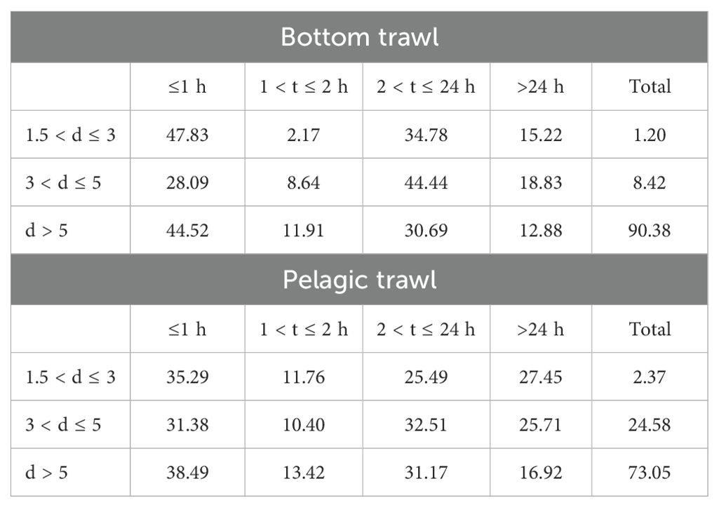
Table 1. AIS data gaps by distance from the coast (t) and duration (d), for bottom and pelagic trawlers.
To give an indication of the derived further results, we present data from a bottom trawler, showing repeated patterns of gaps starting and ending on the western border. Figure 1 compares its speed variations on two days. Figure 1 (left) shows uninterrupted AIS reporting on 28-03-2022, with speeds consistently within trawling thresholds (dashed lines, Ferrà et al., 2020). Figure 1 (right), highlights two AIS gaps (2h23m and 3h39m), where speed data was interrupted (day: 19-10-2022). Straight red lines connect positions before and after signal loss, illustrating temporal gaps. These AIS interruptions complicate trawling activity analysis, emphasizing the challenges AIS gaps pose for monitoring vessel operations.
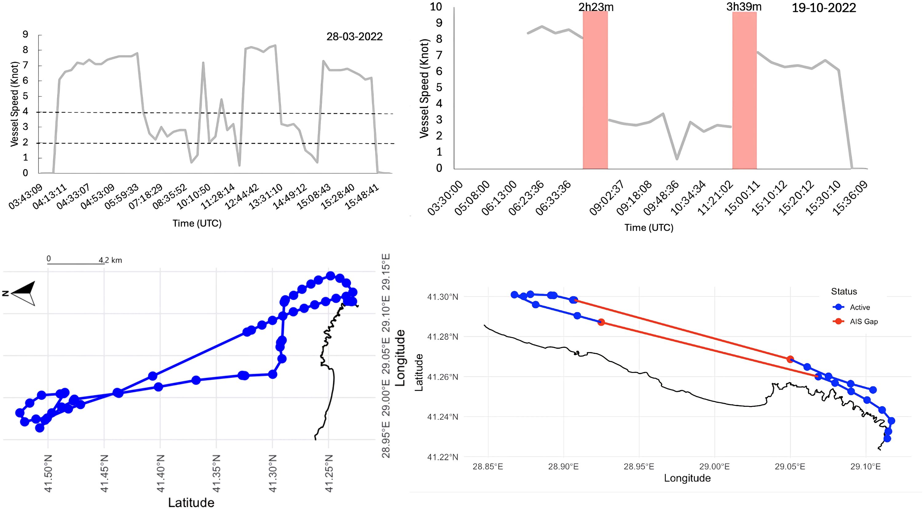
Figure 1. Vessel movement and speed profile for a trawler on 2 different days. Active AIS signals are in blue while AIS gaps in red.
Duration analysis
The analysis of AIS gap durations reveals distinct patterns between vessel types and operational zones. For bottom trawl vessels (Figure 2), the longest average gaps in forbidden zones occurred in January (290 minutes), while the shortest were observed in September (74 minutes). Overall operations showed maximum gap durations in April (214 minutes) and minimum durations in November (71 minutes). Pelagic trawl vessels (Figure 3) exhibited their most severe gaps in forbidden zones during March (486 minutes) and the briefest in November (54 minutes). For general operations, peak gaps appeared in April (312 minutes) with the lowest values recorded in November (79 minutes). Notably, forbidden zone gaps consistently exceeded general operation gaps for both vessel types throughout the monitoring period. The data also shows pelagic trawlers maintained substantially longer gap durations than bottom trawlers across all months, with particularly pronounced differences during the autumn months (September-November).
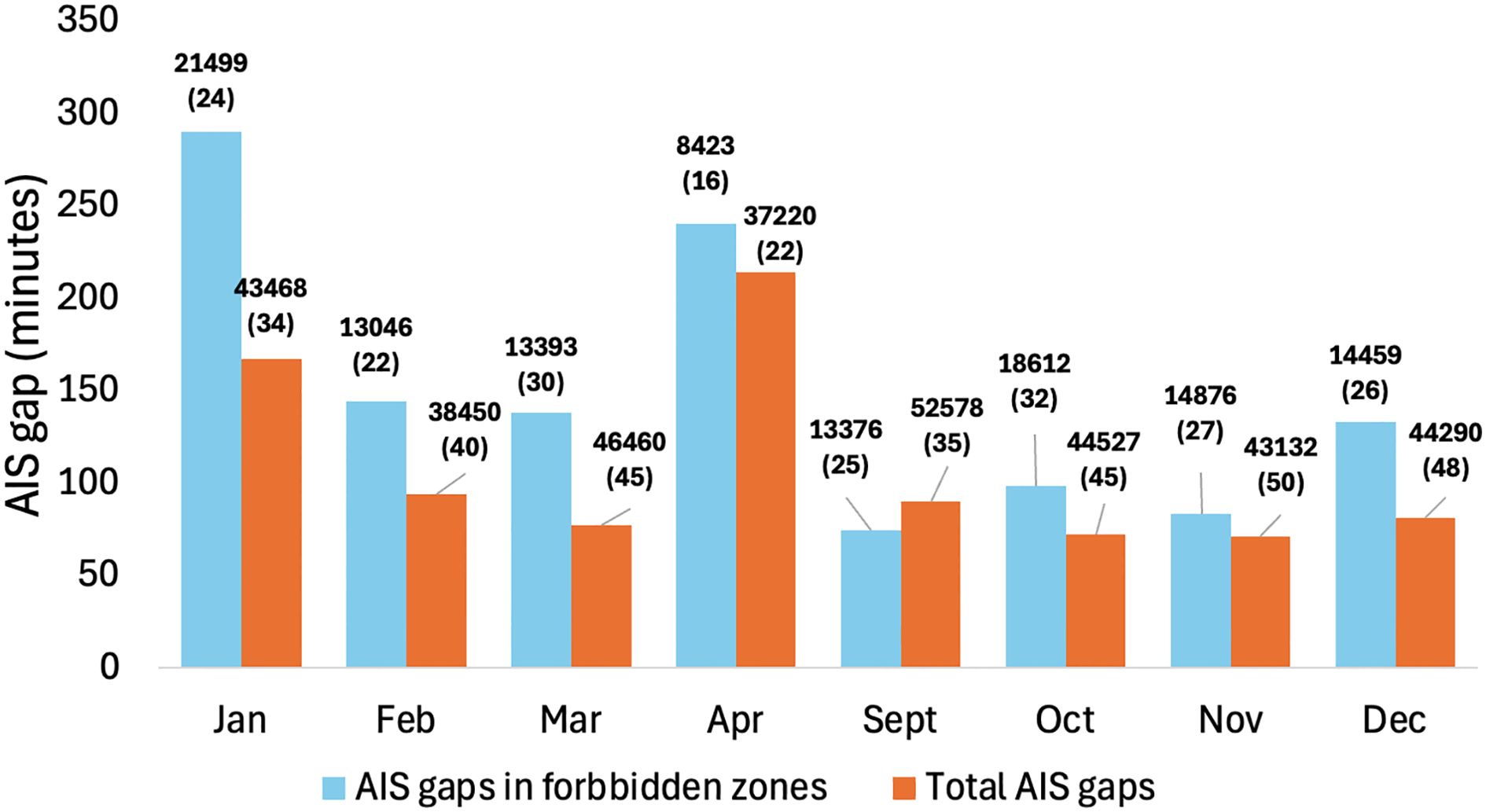
Figure 2. Distribution of mean AIS gap durations (minutes) in forbidden zones (blue) and overall (orange) by month for bottom trawl vessels. Numbers on top of bars indicate total number of gaps (number of vessels).
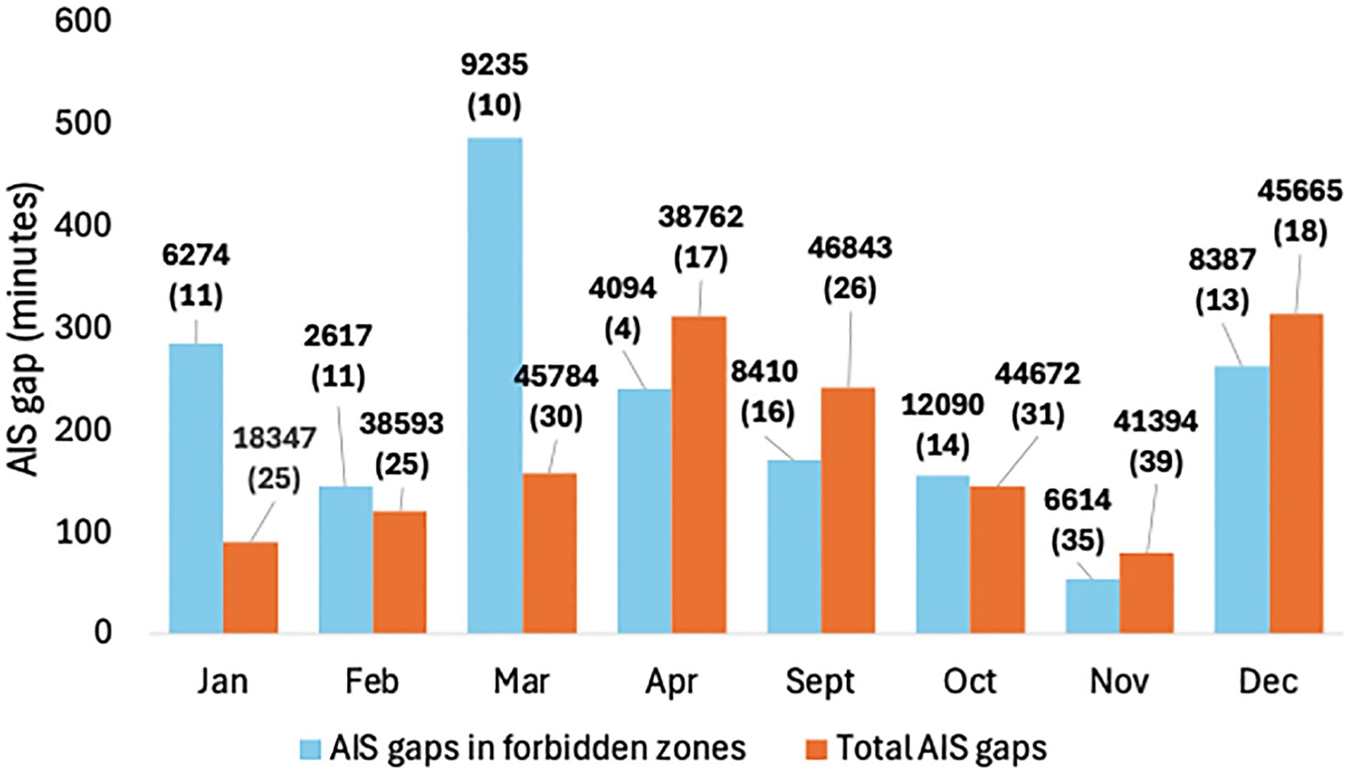
Figure 3. Distribution of mean AIS gap durations (minutes) in forbidden zones and overall by month for pelagic trawl vessels. Numbers on top of bars indicate total number of gaps (number of vessels).
The spatial distribution of AIS gaps durations is visualized on two maps along the Turkish Black Sea coastline (Figure 4). Pelagic trawl gaps are concentrated along the western and central Black Sea coast, with the highest densities near Samsun extending eastward. In contrast, bottom trawl gaps cluster near the northern entrance of the Istanbul Strait. While both trawling types overlap spatially, bottom trawl closures are more concentrated in the western and northwestern coastal regions, decreasing eastward. Pelagic trawl gaps display a more uniform spread, with higher densities in the central Black Sea compared to bottom trawl closures, which are more localized near major fishing ports. These findings highlight geographical variations in AIS gap frequencies, influenced by the trawling type and regional fishing efforts.
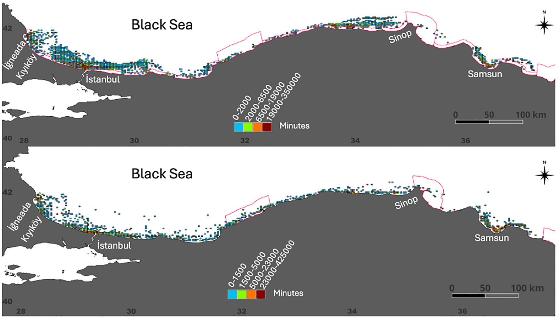
Figure 4. Geographical distribution of AIS gaps durations (minutes) along the Turkish Black Sea coastline for bottom (up) and pelagic trawl (down). Red buffer zone indicates the forbidden zones for bottom and pelagic bottom trawl fisheries.
Port-level patterns
Figure 5 presents the spatial distribution of average AIS gaps associated with ports for bottom trawl and pelagic trawl operations in the Black Sea. The size and color intensity of the circles represent the average number of AIS gaps linked to each port, providing insight into the differences in operational behavior between the two fishing methods. Overall, the patterns for bottom trawl and pelagic trawl are similar, with many ports overlapping in both fisheries. However, some distinctions emerge in terms of gap intensity and specific port utilization. For bottom trawl operations, the highest average AIS gaps are observed in ports near the Istanbul Strait and adjacent western Black Sea, including Rumelifeneri (27.4), Karaburun (28.9), Yeniköy (19.9), and Şile (22). Additionally, ports such as Riva (18.2), Kefkenadası (15.7), and Kıyıköy (12.1) also show relatively high AIS gap densities. For pelagic trawl operations, while some of the same western ports remain prominent (e.g., Kıyıköy (12.9), Rumelifeneri (9.5), Karaburun (9.9), and Şile (5.3)), the distribution extends further into the central and eastern Black Sea. The ports with the highest AIS gaps for pelagic trawl include Tekkeköy (10.2), 19 Mayıs (6.9), and Yeniköy (6.8), which are less prominent in bottom trawl operations. Although the differences in intensity are not extreme, pelagic trawl operations appear to be more dispersed along the coast, whereas bottom trawl gaps are concentrated around key western ports. Additionally, the difference in the number of active vessels (86 bottom trawlers vs. 50 pelagic trawlers) likely influences the relative intensity of AIS gaps between the two fishing methods.
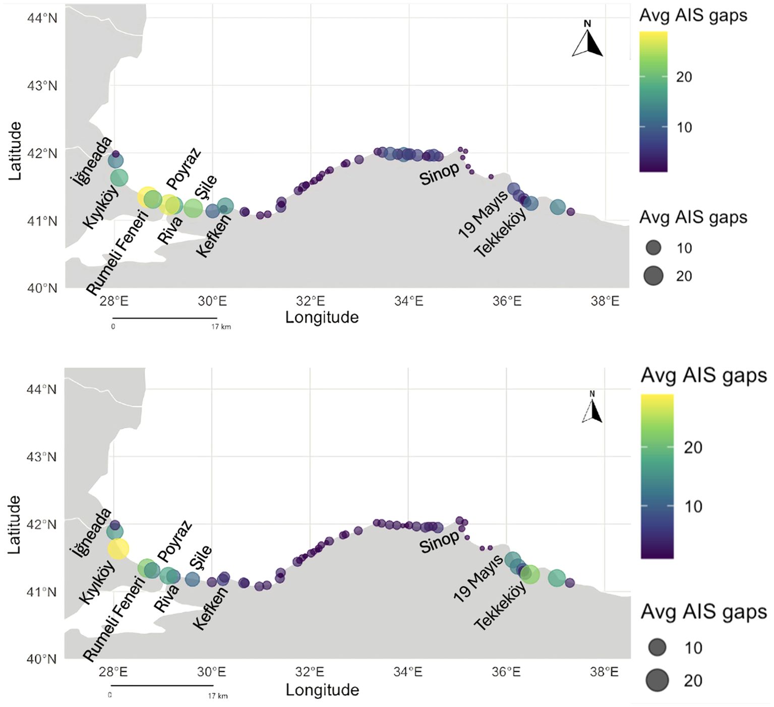
Figure 5. Port-level AIS gap distribution averaged counts for Turkish bottom (up) and pelagic trawl (down) in the Black Sea.
Variance thresholds ensured that no predictor was constant or near-constant, while the correlation threshold minimized risks of multicollinearity. The VIF values are well below the commonly accepted threshold of 5 (Kutner et al., 2004; O’Brien, 2007; James et al., 2013), indicating the absence of serious multicollinearity. These results confirm that the selected variables are not highly correlated (Figure 6) and can be reliably used in further statistical modeling without concerns regarding redundancy or instability.
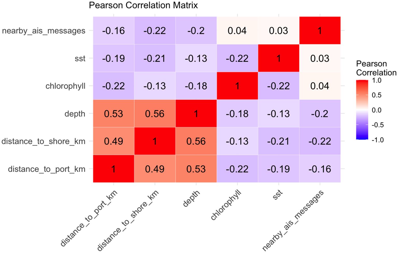
Figure 6. Pearson correlation matrix among key environmental and AIS-related predictors, including distance to port, distance to shore, depth, chlorophyll, sea surface temperature, and nearby AIS messages. Stronger correlations are highlighted in red, while weaker or negative correlations are shown in shades of blue or purple.
Model performance
For bottom trawl fishing gaps, the model demonstrated strong predictive capabilities across classification-based evaluation metrics. The model achieved an accuracy of 80.26%, an AUC of 0.8855, and a True Skill Statistic (TSS) of 0.6052, indicating a good balance between sensitivity and specificity. Additionally, Cohen’s Kappa value of 0.6053 suggests substantial agreement between predicted and observed classifications, confirming the model’s effectiveness in distinguishing AIS gaps. In contrast, when considering AIS gap duration as a continuous variable, the model’s explained variance was 92.63%, and the R² was 94.92%, suggesting that the model successfully captures the variance in gap durations. However, error metrics indicate a mean absolute error (MAE) of 1336.74 minutes (~22.3 hours) and a root mean squared error (RMSE) of 3205.54 minutes (~53.4 hours). RMSE suggests that while the model captures broad patterns, it struggles with precise predictions for long-duration gaps, potentially due to extreme outliers. Feature importance analysis identified chlorophyll concentration and distance to shore as the most influential predictors (Figure 7). Partial dependence plots indicate that AIS gap probability increases sharply at chlorophyll concentrations above ~3.5 mg/m³, while proximity to shore exhibits a decreasing effect beyond 20 km (Figure 8). Spatially, AIS gaps in bottom trawling were more prevalent near the Istanbul Strait and the western Black Sea, reflecting concentrated operational zones.
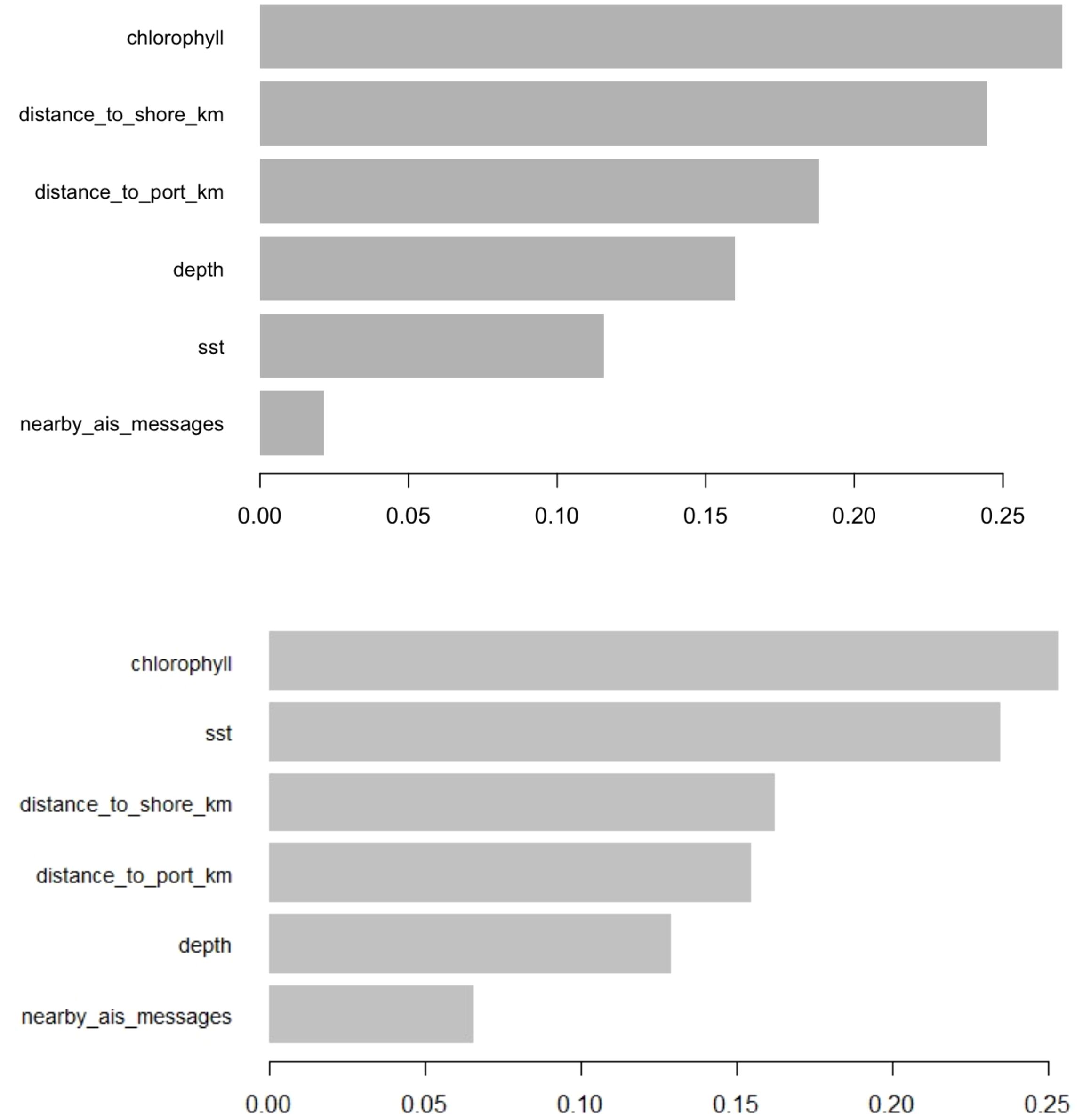
Figure 7. Relative importance of environmental and spatial variables in predicting AIS gaps for bottom trawl (upper) and pelagic trawl (Lower) activities.
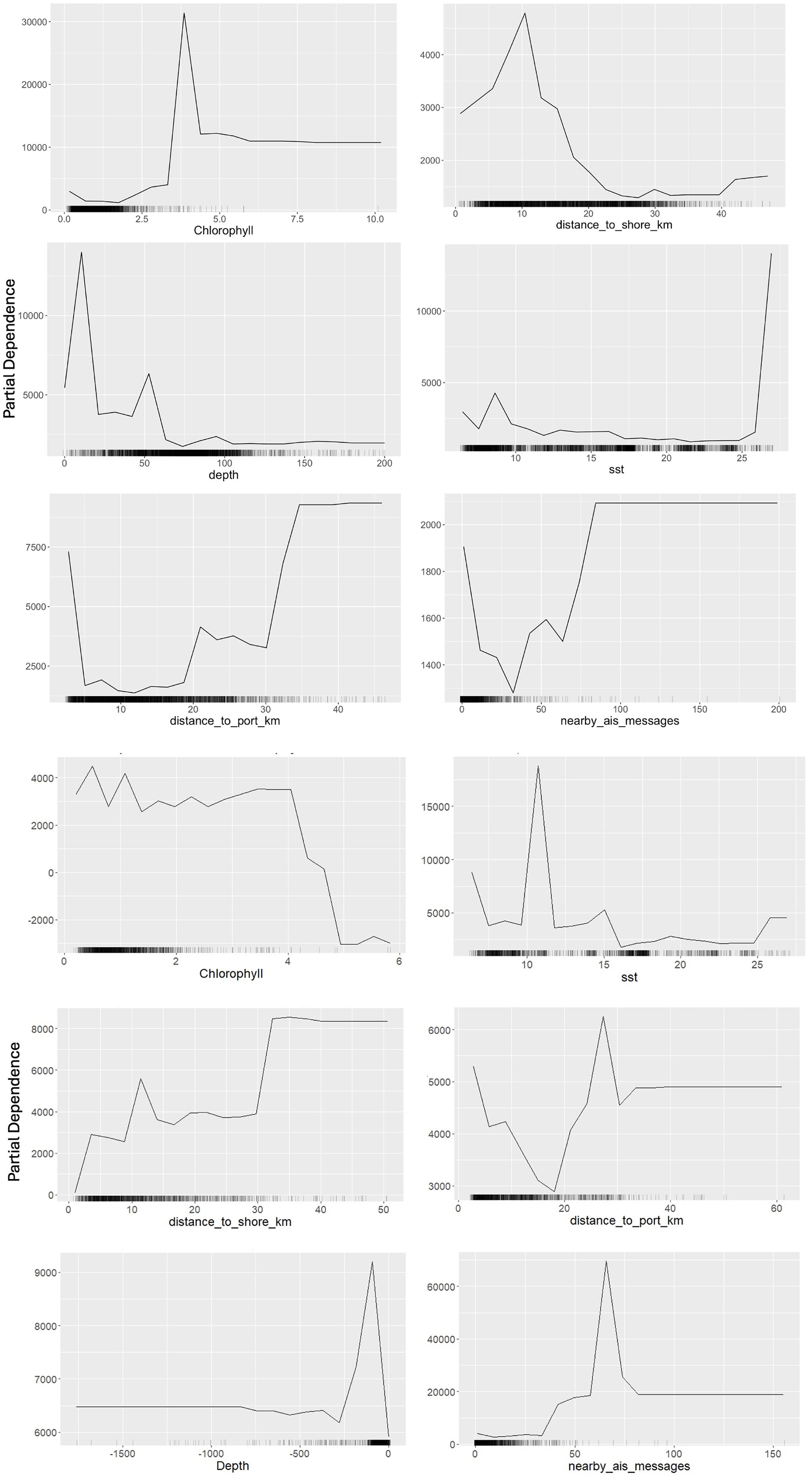
Figure 8. Partial dependence plots depict the influence of environmental variables (e.g., chlorophyll, sea surface temperature) and spatial features (e.g., distance to shore, port) on AIS gap durations for bottom trawl (upper) and pelagic trawl (Lower).
For pelagic trawl fishing gaps, the classification-based performance metrics indicated moderate predictive capabilities. The model achieved an accuracy of 61.68%, an AUC of 0.6663, and a TSS of 0.2336, reflecting limited success in differentiating true gaps from non-gaps. Similarly, Cohen’s Kappa value of 0.2336 suggests only slight agreement between predictions and observations, indicating the model struggles to accurately classify AIS gaps in pelagic trawl activities. When modeling AIS gap duration, the explained variance reached 95.73%, with an R² of 97.03%, suggesting the model captures the overall trend well. However, the MAE of 2011.05 minutes (~33.5 hours) and RMSE of 4400.40 minutes (~73.3 hours) indicate that the model exhibits high absolute error, particularly in longer-duration gaps. This suggests that while the model accounts for broad variance, it struggles with precise forecasting, especially for extreme values. Feature importance analysis identified chlorophyll concentration and sea surface temperature as key predictors. Partial dependence plots (Figure 8) indicate that AIS gaps increase significantly at SST levels around 15 °C, while chlorophyll concentration exerts the strongest influence between 2 mg/m³ and 5 mg/m³. These results underscore the significance of environmental variables like chlorophyll and SST, as well as spatial factors such as proximity to ports and the shoreline, in explaining AIS gaps for both bottom and pelagic trawl fishing. The feature ‘Nearby Vessel Activity’ showed limited explanatory power in the model, ranking among the least influential variables in predicting AIS gaps for both trawl types.
Discussion
This study provides a comprehensive analysis of AIS transmission gaps in the Turkish Black Sea trawl fleet, identifying geographic hotspots and patterns of AIS interruptions. Employing a machine learning approach, it assesses potential correlations between AIS gaps and spatial (e.g., distance to shore/port), environmental (e.g., SST, chlorophyll), and vessel activity variables. The findings align with previous research on vessel tracking and potential unreported fishing activities in other regions, such as the Adriatic Sea (Coro et al., 2023; Ferrà et al., 2020), while also exploring possible underlying causes of AIS gaps.
AIS gaps and fishing activity
A key feature of our analytical framework was the use of a dual-model design. Although the distribution patterns appear similar across the study area, the ranking of factors influencing this distribution varies between bottom and pelagic trawlers. Bottom trawlers exhibited significant concentrations of AIS gaps near the northern entrance of the Istanbul Strait and other nearshore areas. This behavior aligns with anecdotal and regulatory observations that bottom trawlers tend to operate in shallower waters. The tendency to move into shallower regions may be influenced by the presence of high-value demersal species, including red mullet (Mullus barbatus), whiting (Merlangius merlangus), and turbot (Scophthalmus maximus), which are key targets for bottom trawl fisheries. These shallower zones, although sometimes adjacent to areas with regulatory restrictions, are often associated with rich demersal habitats. While fishers may be drawn by the economic value of species like red mullet, some of these activities may inadvertently or intentionally encroach upon forbidden zones. While larger whiting are often found in deeper waters, red mullet, which is smaller but highly abundant in shallow areas, offers a more lucrative return due to its market demand and higher catch volumes (Yildiz, 2016; Yildiz and Karakulak, 2018). This economic incentive likely explains the increased occurrence of AIS gap in shallower waters, as vessels may switch off AIS to evade detection while engaging in illegal fishing. Signal gaps near exclusive economic zones suggest that some vessels deliberately conceal unauthorized border crossings to fish in forbidden zones. While not all vessels that deactivate AIS for extended periods are necessarily engaged in illicit activities, the intentional act of going ‘dark’ raises concerns (Bunwaree, 2023). The western Black Sea has historically been Türkiyey’s primary trawling ground along Black Sea coast, with ports such as İğneada-Kıyıköy and Rumelifeneri-Poyrazköy hosting a high concentration of trawlers. This long-standing significance is reflected in the elevated number of AIS gaps recorded around these ports, indicating intensified fishing activity in the region.
According to Dağtekin et al., 2021, Turkish pelagic trawl fishing is mainly located in the Middle Black Sea along a coastline of 116 km from Taşkana Cape (40°01 E, 43°39 N) to Çayağzı Cape (41°55 E, 41°52 N). Unlike bottom trawlers whose AIS gaps are concentrated near ports, in contrast, pelagic trawlers exhibited a more widespread distribution of AIS gaps, reflecting their operational strategy of targeting pelagic species such as anchovy (Engraulis encrasicolus), horse mackerel (Trachurus mediterraneus), and bluefish (Pomatomus saltatrix). Pelagic trawling was first introduced in the Western Black Sea in 2010 with a limited number of vessels. At the time, the absence of restrictions on gear changes during the fishing season led fishers to use midwater trawls primarily during the peak season. In recent years, however, the number of vessels adopting this method has increased due to the high catch potential and the resulting economic benefits. Unlike bottom trawling, which is closely tied to benthic habitats, pelagic trawlers adjust their movements more dynamically in response to the distribution and migration of their target species. This reliance on fish movement may explain why environmental factors such as sea surface temperature ranked more in predicting AIS gaps for pelagic trawl operations, as pelagic schools respond more directly to temperature variations, influencing fishing vessel behavior. The widespread adoption of pelagic trawling in the Black Sea began in the waters off Samsun (central Black Sea), primarily for sprat catching (Özdemir et al., 2006). Samsun et al. (2006) reported that anchovy is intensively caught between November and January while sprat is abundant in March and April, making pelagic trawling particularly effective for these species. This may explain why AIS gaps for pelagic trawlers increase in spring.
Previous studies (Coro et al., 2023; Ferrà et al., 2020), have demonstrated the utility of AIS and VMS data in analyzing fishing activities, including potential unreported fishing efforts. While Coro et al. (2023) developed a workflow for analyzing tracking data, their analysis primarily focuses on AIS rather than VMS. These studies indicate that gaps in AIS transmission could result from both technical issues and intentional disabling, particularly in areas with restricted access or heightened regulatory control. Coro et al. (2023) stated that such gaps might also correspond to voluntary transmission switch-offs, especially in (or around) prohibited or protected areas. While we considered all AIS gaps exceeding 30 minutes (as in Ferrà et al., 2020), Coro et al. (2023) identified potential unreported activity based on specific AIS gap duration ranges, suggesting a nuanced approach in detecting unreported fishing efforts. Coro et al. (2023) developed a workflow that prioritizes spatial overlap between fishing activity and protected zones, a principle which supports our own observation that signal gaps cluster near high-regulation areas. Welch et al. (2022) developed a model to identify AIS gaps likely caused by intentional disabling. Unlike our approach, Welch et al. (2022) primarily focused on gaps exceeding 12 hours and occurring more than 50 nautical miles from shore, incorporating additional factors such as loitering behavior, proximity to restricted areas, and piracy risks. While our findings indicate that AIS gaps in the Black Sea are concentrated in specific coastal areas rather than in offshore waters, Welch et al. (2022) identified hotspots of AIS disabling near contested Exclusive Economic Zones (EEZs) and regions of high transshipment activity. Welch et al. (2022)’s identification of gaps beyond 50 NM offers a useful contrast to our study, which finds nearshore concentration of AIS gaps—suggesting differences in enforcement strategies and vessel behavior across regions.
While AIS devices can be disabled to conceal illegal activities (Bunwaree, 2003; Galdelli et al., 2021), there is also evidence suggesting that interruptions may occur during legal fishing operations, such as during open season in designated areas. Chlorophyll emerged as a significant driver of AIS deactivation for both trawl types, indicating that fishers may intentionally switch off AIS devices to prevent competitors from identifying productive fishing grounds. However, multiple motivations are possible, including competition avoidance (as expressed by fisher), masking IUU activities (during open season in forbidden zones). Since trawl fishing activity is spatially concentrated on continental shelves, it is far more localized and dense compared to other fishing methods, making competition particularly relevant for this gear type. In the Black Sea, the narrow continental shelf further intensifies this spatial concentration (Yıldız, 2016), forcing vessels to operate within forbidden zones, which may contribute to the strategic deactivation of AIS to avoid detection by other fishers. Although these patterns do not directly indicate IUU fishing, intense fishing pressure—exacerbated by limited available fishing grounds—has contributed to overexploitation and population declines in many commercially important stocks.
The decision to disable AIS transmissions may be partly rooted in broader socio-economic challenges faced by Turkish small- and medium-scale fishers. Several studies have documented how limited fishing grounds, increasing operational costs, and shrinking profit margins have contributed to heightened economic pressure across the sector (Ünal and Ulman, 2020; Sağlam et al., 2016; Şahin, and Özekinci, 2020). These pressures are particularly acute in coastal communities where fishers rely heavily on high-value target species to sustain livelihoods (Doğan, 2010). In this context, the strategic deactivation of AIS may be perceived not only as a means to avoid detection during illegal fishing, but also as a competitive tactic to conceal productive grounds from other vessels (Ünal et al., 2009). This behavior aligns with observations from recent field interviews and surveys indicating that some fishers express mistrust in monitoring technologies and fear data-sharing may undermine their economic resilience. Moreover, studies have highlighted that despite national regulations such as BAGIS enforcement, awareness and compliance vary significantly depending on vessel size, education level, and engagement with cooperatives (Birkan and Öndes, 2020; Doğan, 2018). These findings reinforce the importance of addressing socio-economic vulnerabilities in tandem with technological and legal monitoring strategies, as fishers’ responses to regulation are shaped not only by enforcement capacity but also by livelihood imperatives and perceived fairness of governance.
Machine learning insights
To comprehensively capture both the occurrence and duration of AIS gaps, we adopted a dual-model approach using XGBoost. Specifically, we trained a classification model to predict whether an AIS gap would occur, and a separate regression model to estimate the duration of the gap in minutes. This two-model structure enabled us to disentangle different aspects of vessel behavior, allowing for more interpretable results. It also helped identify which variables were more influential in predicting the likelihood of AIS deactivation versus those affecting the length of signal silence.
The use of XGBoost regression models allowed for detailed predictions of AIS gap durations, demonstrating high explained variance and R² values for both pelagic and bottom trawl datasets. While our findings highlight the effectiveness of machine learning in capturing AIS data patterns, they should be interpreted with caution. Wolsing et al. (2022) reviewed various anomaly detection approaches in AIS data and noted that while machine learning methods are frequently used their review does not explicitly conclude that machine learning is superior for identifying patterns. Rather, it emphasizes the diversity of approaches and the need to evaluate model suitability based on specific maritime contexts. Our results contribute to this discussion by demonstrating the predictive utility of machine learning when tailored to fishing-specific variables. The high accuracy and low error metrics in our models underscore their reliability, offering actionable insights for fisheries management and regulatory bodies. Notably, the bottom trawl model outperformed the pelagic trawl model across all evaluation metrics, including accuracy, AUC, TSS, and Kappa. This suggests that environmental and operational factors, such as depth and proximity to shore, are stronger predictors for bottom trawl activities. In contrast, the weaker performance of the pelagic trawl model indicates that additional features, such as migratory patterns of pelagic species or dynamic oceanographic variables, may be necessary to enhance predictive accuracy.
Implications for ecosystem and regulatory monitoring
The concentration of AIS signal gaps in nearshore areas where trawlers frequently operate indicates potential challenges for monitoring and protecting coastal waters. Identifying and understanding the spatial distribution of these gaps can help refine compliance strategies and support sustainable fisheries in ecologically sensitive zones. Clustering of AIS gaps in shallow waters near the Istanbul Strait suggests priority areas for compliance monitoring. However, further investigation is needed to distinguish whether these gaps primarily result from transmission issues or intentional AIS disabling, as noted in previous studies. Future research should integrate external sources (e.g., Fishing Vessels Monitoring System (Balıkçı Gemilerini İzleme Sistemi - BAGIS) or independent vessel monitoring reports) to better understand the causes of these gaps and refine enforcement strategies accordingly. According to the relevant authority, the Vessel Monitoring Device installed on Turkish fishing vessels sends the position, speed and direction information of the vessel received at 10 minutes intervals to the Vessel Monitoring Centre primarily via GSM, and if the vessel is outside the GSM coverage area, via Satellite, and this frequency seems to be sufficient to reveal the mentioned analysis.
Although AIS data gaps may occur due to technical issues unrelated to deliberate disabling, ad-hoc interviews were conducted informally with fishers during field visits between 2022 and 2023. These insights, while not part of a structured survey, provided qualitative support for observed AIS deactivation patterns. To examine this hypothesis, the variable Nearby Vessel Activity was included in the model, based on the assumption that increased vessel density might influence AIS behavior. However, analysis showed this variable had the least explanatory power, indicating that fishers’ justification may not fully explain the observed AIS gaps. According to the Regulation on the Equipping and Use of AIS Devices by Marine Vessels (Official Gazette No. 28510, 2016), vessels equipped with AIS must ensure continuous operation except during dry dock, system malfunction, or extreme weather conditions. Fishing vessels with AIS Class B devices cannot view other fishing vessels’ signals, but non-fishing vessels and coastal stations can access all AIS transmissions (Official Gazzette, 2022). Non-fishing vessels can monitor all AIS messages, including those from fishing vessels, and AIS Coastal Stations and non-fishing vessels can view fishing vessel data. One key limitation of this study is its reliance solely on AIS data from fishing vessels, which restricts insights into interactions with commercial, recreational, or other non-fishing vessels. In highly trafficked areas such as the Istanbul Strait—a major international shipping corridor—these unaccounted interactions may influence AIS transmission behavior in complex ways. For a more precise assessment, additional data on the overall maritime traffic, including commercial and transport vessels, would be necessary. This is particularly relevant in high-traffic areas such as the Istanbul Strait, which serves as a major international shipping route with a high volume of cargo ships, tankers, and passenger vessels. The presence of these large vessels may influence AIS transmission patterns in ways not fully accounted for in this study. Future research would include both fishing and non-fishing vessels, and provide a more comprehensive understanding of the factors influencing AIS transmission behavior in Turkish waters. Several studies (e.g., Iphar et al., 2019; Welch et al., 2022) have shown that AIS transmission can be affected by surrounding traffic density, especially in regions with large commercial vessel flows, such as straits or transshipment zones.
Regulatory enforcement in Türkiye has identified significant trawl violations, with a 2019 study reporting that nearly 60% of these violations occurred in the Gulf of Samsun–Sinop İnceburun region and 40% in the Black Sea Ereğli-Kefken region (Karabacak and Deval, 2023). Additionally, 28% of recorded trawl violations were in Istanbul (Karabacak and Deval, 2023). In 2022, the most common fisheries violations (25% of all legal actions) were related to field and seasonal restrictions (Turkish Coast Guard Commande, 2022). These patterns, combined with enforcement reports, suggest a possible link between AIS gaps and illegal fishing practices. However, since AIS is used primarily for real-time tracking rather than retrospective monitoring, such gaps rarely lead to formal sanctions. Moreover, there is no fishing vessel actually penalized if the AIS device is closed outside the specified limits. All licensed fishing vessels over 12 meters must install and maintain BAGIS devices, which transmit real-time data on location, speed, and fishing activities to authorities. Operators must ensure continuous BAGIS operation. If a device stops transmitting for six hours, they must report the issue within 12 hours. Failure to do so results in the device being classified as inoperative, risking compliance penalties. Unlike AIS, which is not regularly audited unless integrated with national monitoring programs, BAGIS is directly managed by Turkish authorities. Article 22 of the Fisheries Regulation requires mandatory BAGIS reporting and outlines penalties for non-compliance, including suspension of fishing licenses (Resmi Gazete, 2016) (Denizhaber.net, 2017; 7Deniz.net, 2024; Denizhaber.com, 2024). Scientific analyses indicate that Vessel Monitoring Systems (VMS) provide broader fleet coverage and stronger legal enforcement capacity, while Automatic Identification Systems (AIS) offer high-resolution monitoring in coastal areas and greater public transparency. For example, the studies by Hintzen et al. (2012) and Vespe et al. (2016) demonstrated that AIS enables intensive tracking near ports, whereas VMS covers wider marine areas. Additionally, research by Guillot et al. (2017) and Watson and Haynie (2016) emphasized that combining both systems can significantly enhance monitoring accuracy. As also noted by the FAO (2007), AIS was originally developed for maritime safety, whereas VMS is a system specifically designed for fisheries monitoring, providing encrypted and regular data transmission to regulatory authorities. This distinction highlights the regulatory gap in AIS oversight, despite its broader visibility in vessel tracking systems. In conclusion, this study contributes to the broader discourse on sustainable fisheries management, emphasizing the critical role of AIS data and machine learning techniques. By addressing gaps in monitoring and providing actionable insights into fishing behaviors, it supports efforts to combat IUU fishing and promote ecosystem resilience, aligning with global conservation goals. These findings emphasize the urgent need for integrated monitoring systems and policy reforms that align national enforcement tools with international best practices in fisheries governance.
Data availability statement
The raw data supporting the conclusions of this article will be made available by the authors, without undue reservation.
Author contributions
TY: Conceptualization, Data curation, Formal analysis, Funding acquisition, Investigation, Methodology, Project administration, Resources, Software, Validation, Visualization, Writing – original draft, Writing – review & editing. NC: Data curation, Formal analysis, Investigation, Resources, Visualization, Writing – original draft, Writing – review & editing. CF: Formal analysis, Investigation, Methodology, Supervision, Validation, Writing – original draft, Writing – review & editing. US: Formal analysis, Investigation, Methodology, Validation, Visualization, Writing – original draft, Writing – review & editing. AG: Formal analysis, Investigation, Methodology, Supervision, Validation, Visualization, Writing – original draft, Writing – review & editing. AT: Data curation, Formal analysis, Investigation, Supervision, Validation, Visualization, Writing – original draft, Writing – review & editing.
Funding
The author(s) declare financial support was received for the research and/or publication of this article. This study was supported by Istanbul University BAP Scientific Research Projects Coordination Unit. Project number: FBA-2023-39669.
Acknowledgments
This work was partially funded under the National Recovery and Resilience Plan (NRRP), Mission 4 Component 2 Investment 1.4 - Call for tender No. 3138 of 16 December 2021, rectified by Decree n.3175 of 18 December 2021 of Italian Ministry of University and Research funded by the European Union – NextGenerationEU, in the framework of the NBFC - National Biodiversity Future Center (project code CN_00000033, Concession Decree No. 1034 of 17 June 2022 adopted by the Italian Ministry of University and Research, CUP B83C22002930006).
Conflict of interest
The authors declare that the research was conducted in the absence of any commercial or financial relationships that could be construed as a potential conflict of interest.
Generative AI statement
The author(s) declare that no Generative AI was used in the creation of this manuscript.
Any alternative text (alt text) provided alongside figures in this article has been generated by Frontiers with the support of artificial intelligence and reasonable efforts have been made to ensure accuracy, including review by the authors wherever possible. If you identify any issues, please contact us.
Publisher’s note
All claims expressed in this article are solely those of the authors and do not necessarily represent those of their affiliated organizations, or those of the publisher, the editors and the reviewers. Any product that may be evaluated in this article, or claim that may be made by its manufacturer, is not guaranteed or endorsed by the publisher.
References
7Deniz.net. (2024). İzleme sistemini açmadan avlanan gemiye para cezası. 7Deniz. Available online at: https://www.7deniz.net/izleme-sistemini-acmadan-avlanan-gemiye-para-cezasi (Accessed March 15, 2025).
Agnew D. J., Pearce J., Pramod G., Peatman T., Watson R., Beddington J. R., et al. (2009). Estimating the worldwide extent of illegal fishing. PloS One 4.2, e4570. doi: 10.1371/journal.pone.0004570
Birkan R. and Öndes F. (2020). Socio-economic characteristics of small-scale fisheries in the Aegean Sea, Turkey (eastern Mediterranean). Acta Ichthyologica et Piscatoria 50, 257–268. doi: 10.3750/AIEP/02840
Bunwaree P. (2023). ‘The illegality of fishing vessels going dark and methods of deterrence’ International and Comparative Law Quarterly. Available online at: https://doi.org/10.1017/S0020589322000525 (Accessed January 9, 2025).
Cappa P., Andreoli V., Krueger K., Barrie S., La C., and Zeller D. (2024). Estimating fisheries catch from space: Comparing catch estimates derived from AIS fishing effort with reported catches for Indian Ocean industrial fisheries. Regional Stud. Mar. Sci. 77, 103632. doi: 10.1016/j.rsma.2024.103632
Chamberlain S., Tupper B., and Mendelssohn R. (2019). rerddap: General purpose client for’ERDDAP’servers. R package version 0.4 2. Available online at: https://CRAN.R-project.org/package=rerddap (Accessed January 23, 2025).
Chen T., et al. (2023). xgboost: Extreme Gradient Boosting. R package version 1.6.0.1. Available online at: https://CRAN.R-project.org/package=xgboost (Accessed February 3, 2025).
Chen T. and Guestrin C. (2016). “XGBoost: A scalable tree boosting system,” in Proceedings of the 22nd ACM SIGKDD International Conference on Knowledge Discovery and Data Mining ACM, New York, NY. 785–794. doi: 10.1145/2939672.2939785
Coro G., Sana L., Ferrà C., Bove P., and Scarcella G. (2023). Estimating hidden fishing activity hotspots from vessel transmitted data. Front. Sustain. Food Syst. 7, 1152226. doi: 10.3389/fsufs.2023.1152226
Dağtekin M., Uysal O., Candemir S., and Genç Y. (2021). Productive efficiency of the pelagic trawl fisheries in the Southern Black Sea. Regional Stud. Mar. Sci. 45, 101853. doi: 10.1016/j.rsma.2021.101853
Demirel N., Zengin M., and Ulman A. (2020). First large-scale eastern mediterranean and black sea stock assessment reveals a dramatic decline. Front. Mar. Sci. 7. doi: 10.3389/fmars.2020.00103
Denizhaber.net. (2017). Balıkçı gemileri izleme sistemini kapatan tekneye ceza kesildi. Deniz Haber. Available online at: https://www.denizhaber.net/balikci-gemileri-izleme-sistemini-kapatan-tekneye-ceza-kesildi-haber-73834.htm (Accessed October 10, 2025).
Doğan K. (2010). İstanbul su ürünleri kooperatifleri ve ortaklarının sosyo-ekonomik analizi. Journal of FisheriesSciences.com, 4(4), 318. doi: 10.3153/jfscom.2010035
Doğan K. (2018). İstanbul ili su ürünleri kooperatiflerinin ticari olanakları ve sorunlarının incelenmesi. Aquat. Res. 1 (4), 180–191. doi: 10.3153/AR18020
Dowle M. and Srinivasan A. (2021). Data. table: Extension of ‘data. frame’(R package version 1.10. 4-3)[Computer software]. Available online at: https://CRAN.R-project.org/package=data.table (Accessed February 11, 2025).
Dunn D. C., et al. (2018). Empowering high seas governance with satellite vessel tracking data. Fish Fisheries 19.4, 729–739. doi: 10.1111/faf.12285
Durlik I., Miller T., Cembrowska-Lech D., Krzemińska A., Złoczowska E., and Nowak A. (2023). Navigating the sea of data: a comprehensive review on data analysis in maritime IoT applications. Appl. Sci. 13, 179742. doi: 10.3390/app13179742
Emmens T., Amrit C., Abdi A., and Ghosh M. (2021). The promises and perils of Automatic Identification System data. Expert Syst. Appl. 178, 114975. doi: 10.1016/j.eswa.2021.114975
FAO (2007). “VMS: vessel monitoring systems – policy, legal and operational guidance,” in FAO technical guidelines for responsible fisheries no. 9 (Rome: Food and Agriculture Organization of the United Nations).
Ferrà C., Tassetti A. N., Armelloni E. N., Galdelli Aa, Scarcella G., and Fabi G. (2020). Using AIS to attempt a quantitative evaluation of unobserved trawling activity in the Mediterranean Sea. Front. Mar. Sci. 7, 580612. doi: 10.3389/fmars.2020.580612
Fox J. and Weisberg S. (2019). An R companion to applied regression. 3rd ed. (Sage: Thousand Oaks CA). Available online at: https://www.john-fox.ca/Companion/ (Accessed February 19, 2025).
Galdelli A., Mancini A., Ferrà C., and Tassetti A. N. (2021). A synergic integration of AIS data and SAR imagery to monitor fisheries and detect suspicious activities. Sensors 21.8, 2756. doi: 10.3390/s21082756
GEBCO Compilation Group (2023). The GEBCO 2023 Grid - a continuous terrain model of the global oceans and land Liverpool: British Oceanographic Data Centre. doi: 10.5285/C6612CBE-50B3-0CFF-E053-6C86ABC09F8F
Greenwell B. M. (2017). pdp: an R package for constructing partial dependence plots. R J. 9, 421–436. doi: 10.32614/RJ-2017-016
Grégoire M., Vandenbulcke L., and Capet A. (2020). “Black sea biogeochemical reanalysis (CMEMS BS-biogeochemistry)(Version 1)[Data set],” in Copernicus monitoring environment marine service (CMEMS) Dordrecht: Springer. doi: 10.25423/CMCC/BLKSEA_ANALYSISFORECAST_BGC_007_010S_PHYS_006_004
Guillot G., Benoit P., Kinalis S., and Bastardie F. (2017). Enhancing and comparing methods for the detection of fishing activity from Vessel Monitoring System data. bioRxiv.
Hastie T., Tibshirani R., and Friedman J. (2009). The elements of statistical learning: data mining, inference, and prediction (Springer).
Hijmans R. J. (2018). raster: Geographic data analysis and modeling. R package version 2. Available online at: https://CRAN.R-project.org/package=raster (Accessed January 31, 2025).
Hijmans R. J. (2023). geosphere: spherical trigonometry. R package version 1.5–18. Available online at: https://CRAN.R-project.org/package=geosphere (Accessed March 4, 2025).
Hintzen N. T., Bastardie F., Beare D., Piet G. J., Ulrich C., and Vermard Y. (2012). VMStools: Open−source software for the processing, analysis and visualisation of fisheries logbook and VMS data. Fisheries Res. 115–116, 31–43. doi: 10.1016/j.fishres.2011.11.007
International Maritime Organization (IMO) (2002). SOLAS chapter V – safety of navigation, regulation 19. Available online at: https://www.imo.org/en/About/Conventions/Pages/Safety-of-Life-at-Sea-(SOLAS).aspx.
Iphar C., Cyril R., and Aldo N. (2019). “Uses and misuses of the automatic identification system,” in OCeAnS 2019-marseille. IEEE Paris: IEEE.
James G., Witten D., Hastie T., and Tibshirani R. (2013). An introduction to statistical learning: with applications in R (Springer).
Jefferson T., Palomares M. L., and Lundquist C. J. (2022). Safeguarding seafood security, marine biodiversity and threatened species: can we have our fish and eat it too? Front. Mar. Sci. 9, 826587. doi: 10.3389/fmars.2022.826587
Joo R., McDonald G., Miller N., Kroodsma D., Farthing C., Belhabib D., et al. (2023). Towards a responsible machine learning approach to identify forced labor in fisheries. arXiv preprint arXiv:2302.10987.
Karabacak G. S. and Deval M. C. (2023). Evaluation of illegal, unreported and unregulated (IUU) trawl infringements committed by turkish fishing vessels. Çanakkale Onsekiz Mart Univ. J. Mar. Sci. Fisheries 6, 124–136. doi: 10.46384/jmsf.1345396
Kerbiriou R., Lévêque L., Rajabi A., and Serry A. (2017). “The Automatic Identification System (AIS) as a data source for studying maritime traffic,” in International Maritime Science Conference University of Montenegro, Kotor, Montenegro.
Kutner M. H., Nachtsheim C. J., and Neter J. (2004). Applied linear regression models. 4th ed (McGraw-Hill).
Litts R. E. (2021). Security improvements for the automatic identification system . Master of science (MS), thesis, electrical & Computer engineering, old dominion university. doi: 10.25777/zjmc-3w82
Liu X., Tao F., and Yu W. (2020). A neural network enhanced system for learning nonlinear constitutive law and failure initiation criterion of composites using indirectly measurable data. Composite Structures 252, 112658. doi: 10.1016/j.compstruct.2020.112658
Malde K., Handegard N. O., Eikvil L., and Salberg A. B. (2020). Machine intelligence and the data-driven future of marine science. ICES J. Mar. Sci. 77.4, 1274–1285. doi: 10.1093/icesjms/fsz057
Mazzarella F., Vespe M., Alessandrini A., Tarchi D., Aulicino G., and Vollero A. S. (2017). A novel anomaly detection approach to identify intentional AIS on-off switching. Expert Syst. Appl. 78, 110–123. doi: 10.1016/j.eswa.2017.02.011
O’Brien R. M. (2007). A caution regarding rules of thumb for variance inflation factors. Qual. Quantity 41, 673–690. doi: 10.1007/s11135-006-9018-6
Oguz T., Akoglu E., and Salihoglu B. (2012). Current state of overfishing and its regional differences in the Black Sea. Ocean Coast. Manage. 58, 47–56. doi: 10.1016/j.ocecoaman.2011.12.013
Orofino S., McDonald G., Mayorga J., Costello C., and Bradley D. (2023). Opportunities and challenges for improving fisheries management through greater transparency in vessel tracking. ICES J. Mar. Sci. 80, 675–689. doi: 10.1093/icesjms/fsad008
Özdemir S., Erdem Y., Satılmış H. H., and Özdemir Z. B. (2006). Karadeniz’de ortasu trolü ile gece süresince avlanan Hamsi (Engraulis encrasicolus, L. 1758)’nin av verimi ve boy kompozisyonunun belirlenmesi.
Öztürk B. (2013). Some remarks of Illegal, Unreported and Unregulated (IUU) fishing in Turkish part of the Black Sea. J. Of Black Sea/Medıterranean Envıronment no.19, 256–267.
Petrovic A., Damaševičius R., Jovanovic L., Toskovic A., Simic V., Bacanin N., et al. (2023). Marine vessel classification and multivariate trajectories forecasting using metaheuristics-optimized extreme gradient boosting and recurrent neural networks. Appl. Sci. 13.16, 9181. doi: 10.3390/app13169181
Pierce D. (2019). ncdf4: Interface to Unidata netCDF (Version 4 or Earlier) Format Data Files, r package version 1.17, R Foundation. Available online at: https://CRAN.R-project.org/package=ncdf4 (Accessed January 14, 2025).
Posit team (2024). RStudio: integrated development environment for R. Posit software (PBC, Boston, MA: Posit Software, PBC). Available online at: http://www.posit.co/.
Resmi Gazete. (2016). Su Ürünleri Yönetmeliği. Resmi Gazete, No. 29608, 13 Ağustos 2016. Available online at: https://www.resmigazete.gov.tr/eskiler/2016/08/20160813-17.pdf (Accessed March 20, 2025).
Richard W.R., Banzon V. F., and NOAA CDR Program (2008). NOAA Optimum Interpolation 1/4 Degree Daily Sea Surface Temperature (OISST) Analysis, Version 2. [indicate subset used. NOAA Natl. Centers Environ. Inf. doi: 10.7289/V5SQ8XB5
Şahin E. and Özekinci U. (2020). Küçük ölçekli balıkçılığın sosyo-ekonomik durumu, Çanakkale (Kuzey Ege), Türkiye. Çanakkale Onsekiz Mart University Journal of Marine Sciences and Fisheries 3 (1), 19–26. doi: 10.46384/jmsf.740894
Samsun O., Kalaycı F., Samsun N., and Bilgin S. (2006). Karadeniz’de orta su trolü İle avlanan pelajik balıkların bazı Biyolojik özellikleri ve avcılık verilerinin incelenmesi. Ege J. Fisheries Aquat. Sci. 23, 487–493.
Sağlam N. E., Düzgüneş E., and Özbek G. (2016). Doğu Karadeniz Bölgesi’nde deniz balıkçılarının sosyo-ekonomik yapısı. Journal of Agricultural Faculty of Gaziosmanpaşa University 33 (3), 259–270. doi: 10.13002/jafag986
Shedrawi G., Magron F., Vigga B., Bosserelle P., Gislard S., Halford A. R., et al. (2024). Leveraging deep learning and computer vision technologies to enhance management of coastal fisheries in the Pacific region. Sci. Rep. 14, 20915. doi: 10.1038/s41598-024-71763-y
Silva J. A., Rivera-Hechem M. I., Hong C., Clawson G., Hoover B. R., Butera T., et al. (2022). Assessing the drivers of vessel tracking systems adoption for improved small-scale fisheries management. Ocean Coast. Manage. 226, 106265. doi: 10.1016/j.ocecoaman.2022.106265
Spadon G., Kumar J., Chen J., Smith M., Hilliard C., Vela S., et al. (2024). Maritime tracking data analysis and integration with AISdb. SoftwareX 28, 101952. doi: 10.1016/j.softx.2024.101952
Sumaila U. R. and Tai T. C. (2020). End overfishing and increase the resilience of the ocean to climate change.–frontiers in marine science, Vol. 7. 523.
Taconet M., Kroodsma D., and Fernandes J. A. (2019). Global Atlas of AIS-based fishing activity—Challenges and opportunities.
Turkish Coast Guard Command (2022). 2022 operational activity report. Directorate of Operations, Turkish Coast Guard Command. Available online at: https://www.sg.gov.tr (Accessed March 18, 2025).
Ulman A., Bekisoglu S., Zengin M. A., Knudsen S., Unal V., Mathews C., et al. (2013). From bonito to anchovy: a reconstruction of Turkey’s marine fisheries catches, (1950-2010). Mediterr. Mar. Sci., 309–342. doi: 10.12681/mms.414
Ünal V. and Ulman A. (2020). “The current status and challenges facing the small-scale fisheries of Turkey.” in Small-Scale Fisheries in Europe: Status, Resilience and Governance, 83–103.
Ünal V., Derya Yıldırım Z., and Mümtaz Tıraşın E. (2019). Implementation of the ecosystem approach to fisheries for the small-scale fisheries in Gökova Bay, Turkey: baseline report. FAO Fisheries and Aquaculture Technical Paper No. 646 (Rome: FAO), 68. Licence: CC BY-NC-SA 3.0 IGO.
Ünal V., Göncüoğlu H., and Franquesa R. (2009). An assessment of the impact of coastal fisheries in Turkey on fish stocks and socio-economics of fishers. Ocean Coast. Manage. 52, 467–475. doi: 10.1111/j.1439-0426.2009.01241.x
UNODC (2011). Transnational organized crime in the fishing industry. Focus on: Trafficking in persons, smuggling of migrants, illicit drugs trafficking, Vol. 144.
Vespe M., Gibin M., Natale F., Alessandrini A., Mazzarella F., and Osio G. C. (2016). Mapping EU fishing activities using ship tracking data. ICES J. Mar. Sci. doi: 10.1080/17445647.2016.1195299
Watson J. T. and Haynie A. C. (2016). Using vessel monitoring system data to identify and characterize trips made by fishing vessels in the United States north pacific. PloS One 11, e0165173. doi: 10.1371/journal.pone.0165173
Welch H., Ames R. T., Kolla N., Kroodsma D. A., Marsaglia L., Russo T., et al. (2024). Harnessing AI to map global fishing vessel activity. One Earth 7, 1685–1691. doi: 10.1016/j.oneear.2024.09.009
Welch H., Clavelle T., White T. D., Cimino M. A., Van Osdel J., Hochberg T., et al. (2022). Hot spots of unseen fishing vessels. Sci. Adv. 8, 44, eabq2109. doi: 10.1126/sciadv.abq2109
Wickham H. (2016). ggplot2: Elegant Graphics for Data Analysis. (Springer-Verlag New York). Available online at: https://ggplot2.tidyverse.org.
Wickham H. and Girlich M. (2023). tidyr: Tidy Messy Data. R package version 1.3.0. Available online at: https://CRAN.R-project.org/package=tidyr (Accessed March 28, 2025).
Widjaja S., Long T., Wirajuda H., As H. V., Bergh P. E., Brett A., et al. (2023). “Illegal, unreported and unregulated fishing and associated drivers,” in The blue compendium: from knowledge to action for a sustainable ocean economy (Springer International Publishing, Cham), 553–591.
Wing K. and Woodward B. (2024). Advancing artificial intelligence in fisheries requires novel cross-sector collaborations. ICES J. Mar. Sci. 81.10, 1912–1919. doi: 10.1093/icesjms/fsae118
Wolsing K., Roepert L., Bauer J., and Wehrle K. (2022). Anomaly detection in maritime AIS tracks: A review of recent approaches. J. Mar. Sci. Eng. 10.1, 112. doi: 10.3390/jmse10010112
Yang Y., et al. (2024). Harnessing the power of Machine learning for AIS Data-Driven maritime Research: A comprehensive review. Transportation Res. Part E: logistics transportation Rev. 183, 103426. doi: 10.1016/j.tre.2024.103426
Yildiz T. (2016). The effect of trawl fıshery on commercıal demersal fısh stocks ın the western Black Sea. PhD Thesis. Istanbul Univ. pp, 225.
Yildiz T. and Karakulak F. S. (2018). General characteristics of bottom trawl fishery and effect of haul duration and total catch on discard in the Western Black Sea. SU URUNLERI DERGISI, Vol. 35. 19–26.
Keywords: trawl, AIS gaps, hidden fishing, Black Sea, forbidden zone
Citation: Yildiz T, Cömert N, Ferrà C, Şaşmaz U, Galdelli A and Tassetti AN (2025) Environmental and behavioral drivers of Automatic Identification System gaps of Turkish trawlers in the Black Sea. Front. Mar. Sci. 12:1647930. doi: 10.3389/fmars.2025.1647930
Received: 16 June 2025; Accepted: 01 September 2025;
Published: 25 September 2025.
Edited by:
Fabio Carneiro Sterzelecki, Federal Rural University of the Amazon, BrazilReviewed by:
Fangcheng Han, Ocean University of China, ChinaJenny Suter, National Oceanic and Atmospheric Administration, United States
Copyright © 2025 Yildiz, Cömert, Ferrà, Şaşmaz, Galdelli and Tassetti. This is an open-access article distributed under the terms of the Creative Commons Attribution License (CC BY). The use, distribution or reproduction in other forums is permitted, provided the original author(s) and the copyright owner(s) are credited and that the original publication in this journal is cited, in accordance with accepted academic practice. No use, distribution or reproduction is permitted which does not comply with these terms.
*Correspondence: Taner Yildiz, eWxkenRuckBpc3RhbmJ1bC5lZHUudHI=