Abstract
Maritime transport accounts for approximately 80% of international cargo volume; however, it confronts significant threats from typhoons or hurricanes. Existing typhoon-avoidance strategies are often challenged by uncertainties in the forecast of typhoon intensity and trajectory. This study analyzes the case of a bulk carrier navigating from Australia to China during Typhoon “Doksuri” in 2023. Automatic Identification System (AIS) data and high-resolution meteorological datasets were ultilized, along with an improved Dijkstra algorithm, to construct a navigable typhoon-avoidance route map. A time-minimization objective function incorporating a penalty mechanism for violating typhoon safety distances was established. The bulk carrier adopted four sequential avoidance strategies to evade Typhoon “Doksuri”: reducing speed, front-crossing avoidance, stopping and drifting, and resuming sailing under safe conditions. As a result of these adjustments, the Distance of Closest Point of Approach (DCPA) increased from 101 nautical miles to 183 nautical miles. The maximum encountered wind force was reduced from Beaufort scale 11 to 8, and the significant wave height decreased from 9 meters to 6.5 meters. The research indicates that timely and accurate typhoon forecasts, refined weather and ocean condition forecasts, and precise shore-based meteorological routing services are critical factors for ships to avoid typhoons effectively.
1 Introduction
Maritime transportation constitutes a vital component of global trade, responsible for approximately 80% of international cargo movement by volume (2023) (United Nations Conference on Trade and Development (UNCTAD), 2023). Ships navigating on the sea are constantly exposed to threats from various natural disasters, among which typhoons rank as some of the most severe ones (Wang et al., 2023; Liu et al., 2005). The strong winds and large waves associated with typhoons can inflict structural damage on ships, leading to incidents such as loss of control, collisions, groundings, and even capsizings, thereby posing a substantial threat to property and the lives of crew members.
When ships encounter typhoons in open seas, they typically implement a series of typhoon-avoidance measures to mitigate potential disasters caused by typhoons. Scholars both domestically and internationally have conducted extensive research on the issue of ship typhoon avoidance. Methods such as the fan-shaped avoidance method, the probability forecast circle method, the multi-level decision-making method, the safety distance avoidance and resistance method based on the forecast map, and the dynamic programming method [4-9] have played significant roles in ship typhoon-avoidance operations (Wu et al., 2013; Huang et al., 2022; Zhang et al., 2010; Mannarini et al., 2019; Wu et al., 2014; Zhang et al., 2016). With the development of big data and computer technology, remarkable progress has been made in data-driven ship typhoon-avoidance strategies. Algorithms, including the improved A* algorithm (Wang et al., 2021), the greedy random adaptive search algorithm (Zhang et al., 2023), and the graph search algorithm (Huang et al., 2022), provide effective guarantees for ship route planning and typhoon avoidance under the condition of uncertain typhoon forecasts.
Ship typhoon avoidance at sea is a complex engineering problem that requires the consideration of both safety and economic efficiency. This necessitates a comprehensive consideration of factors such as the ship’s type, draft, stability, wave-resistance capacity, loading condition, and wind and wave forecast information. Typhoon-avoidance strategies include accelerating straight ahead, decelerating straight ahead, course alteration, front-crossing typhoon avoidance (acceleration strategy), rear-crossing typhoon avoidance (deceleration strategy), and parking and drifting (Huang et al., 2022; Zhang et al., 2016; Wang et al., 2021).
This paper takes Bulk Carrier A under the operational service of the Meteorological Routeing Centre of the China Meteorological Administration as a case study. From the perspective of meteorological routing institutions guiding ships to avoid and bypass severe marine weather, it analyzes the typhoon-avoidance measures taken by the ship when affected by Typhoon “Doksuri.” It also compares the changes in wind and wave forecasts and the ship–typhoon distance before and after the route modification. All the times referred to in this paper are Coordinated Universal Time (UTC). Nautical miles (n mile) are used as the unit of distance, and knots (kn) are used as the unit of speed, which are commonly adopted in the routing business.
2 Data and methods
2.1 Ship AIS data
In the field of meteorological routing, the position and navigation information of ships are continuously monitored. These data are sourced from the Automatic Identification System (AIS) installed on ships (Anggani et al., 2023). Through the AIS system, ships can transmit information such as their identity, position, course, and speed to nearby vessels and shore-based AIS stations. Meteorological routing institutions use AIS information, combined with meteorological and hydrological forecast data, to provide meteorological routing services. This approach can significantly enhance the safety and efficiency of maritime routing.
2.2 Meteorological data
In the ship navigation domain, it is essential to estimate the ship’s routing position and provide corresponding forecast information at that location. This information encompasses wind direction, wind speed, the direction and height of wind waves and swells, significant wave height, and the speed and direction of ocean currents, among others. Such forecast data are employed to assess the potential environmental impacts on the ship, and based on this assessment, decisions regarding whether to adjust the routing plan can be made. The services provided by the Meteorological Routeing Centre of the China Meteorological Administration for ships include customized marine meteorological forecasts, gridded forecast data of marine meteorological elements, and graphic and text forecast products. The positioning, intensity determination, and forecast data of typhoons are derived from the real-time typhoon forecast operations of the Central Meteorological Observatory of the China Meteorological Administration. The classification of tropical cyclone grades in the northwestern Pacific Ocean adheres to the Chinese national standard “Tropical Cyclone Grade” GB/T 19201–2006 (General Administration of Quality Supervision, Inspection and Quarantine of the People’s Republic of China and Standardization Administration of China, 2006).
The time resolution of the meteorological data used in this paper is 3h (forecasts are updated every 12h), and the spatial resolution is 0.1° × 0.1° (approximately 10 km × 10 km). The gridded forecast data covers elements such as wind speed, wind direction, significant wave height, wave direction, and ocean current. The data is sourced from the operational numerical forecasting system of the Meteorological Routeing Centre of the China Meteorological Administration.
2.3 Ship typhoon avoidance method
This paper employs the Dijkstra algorithm to address the typhoon avoidance problem by refining the search strategy and planning the shortest-time avoidance route on a discrete route graph network (Huang et al., 2022).
2.3.1 Modeling the typhoon avoidance problem
A complete ship route consists of waypoint locations (including departure and destination ports) and the speed for each leg. Certain waypoints, such as ports, straits, and oceanic routing points, are mandatory passage points. The geographical coordinates of these waypoints are determined during the initial route planning phase and remain unchanged during the weather routing optimization process. A complete ship route is composed of waypoints, denoted as , route legs, denoted as . Here, and represent the latitude and longitude of the k-th waypoint, respectively, denotes the ship’s speed through water, and represents the distance of the route leg.
2.3.2 Objective function for minimum sailing time on avoidance route
In this paper, the optimization objectives are minimizing sailing time. A single-objective optimization function is constructed as follows:
In (Equation 1):
-
represents the total sailing time.
-
is the distance of the i-th route leg.
-
is the ship’s speed through water for the i-th leg.
-
is the penalty function for the safe distance between the ship and the typhoon, designed to enforce avoidance. It is defined as Equation 3:
In (Equation 2):
-
is the distance between the ship and the typhoon center.
-
is the safe distance threshold between the typhoon and the ship.
-
is a large penalty coefficient.
1.3.3 Solving for the avoidance route
A discretized search area is constructed based on the great-circle route, which represents the shortest path between two points on the Earth’s surface and is commonly followed by ships. Fixed waypoints on the planned route are connected using great-circle arcs. A route graph is built upon these great-circle segments. The shortest arc length between waypoints A and B is given by Equation 3:
The initial course angle and the arrival course angle of the great-circle route are:
For any point on the great-circle route, its coordinates and course angle are:
Where represents the ratio of the angular distance of along the great circle. For a point located n miles from , with perpendicular to the great-circle route, the latitude and longitude of Y are:
Where indicates eastward, and indicates westward.
Based on (Equations 4–10), waypoints are calculated at intervals of n miles along the great-circle route and of n miles within a range of n miles perpendicular to the great-circle route. Each waypoint along the great-circle route thus has candidate waypoints , as indicated by the red dots in Figure 1A.
Figure 1
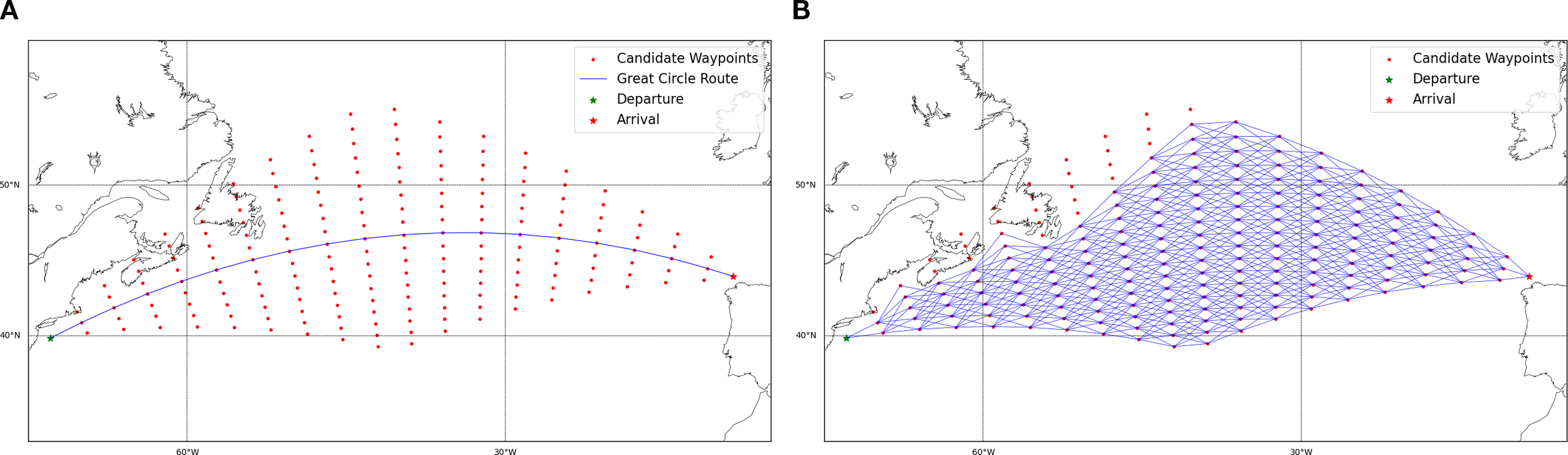
Illustration of the route graph network. (A) Great-circle route with candidate waypoints; (B) Navigable typhoon avoidance route graph network after removing non-navigable segments and isolated waypoints.
Connecting these candidate waypoints forms a complete route graph. Traditional graph connection methods, such as the eight-direction strategy, often fail to meet the requirements of route navigability. Therefore, this study utilizes a regional direction graph connection method. Based on the great-circle route, connections are made within a region aligned with the great-circle sailing direction. Non-navigable segments (e.g., those crossing land) and isolated candidate waypoints resulting from these connections are removed. This process ultimately constructs a navigable typhoon avoidance route graph network (as shown in Figure 1B). Finally, the Dijkstra algorithm is applied to solve for the optimal typhoon avoidance route.
3 Overview of typhoon “Doksuri”
The uncertainty of typhoon forecast position and intensity poses significant difficulties for ship meteorological routing services. Typhoon “Doksuri” (2305) formed over the ocean east of the Philippines at 00:00 on 21 July 2023 (as shown in Figure 2). It strengthened into a severe tropical storm at 21:00 on the 22nd, rapidly developed into a severe typhoon after 00:00 on the 24th, and was upgraded to a super typhoon at 12:00 on the 24th. From the 24th to the 28th, “Doksuri” remained at the level of a severe typhoon or a super typhoon. The forecast for “Doksuri” not only had uncertain intensity predictions, but its trajectory was also shrouded in significant uncertainty. On the 21st, when the typhoon was first numbered, it was forecast that the typhoon would move northwestward, pass by the north of Taiwan, and enter the East China Sea. On the 22nd, it was forecast that the typhoon would deflect southward and make landfall on Taiwan. The forecast on the 23rd showed that the typhoon continued to adjust southward and would travel westward through the Bashi Channel.
Figure 2
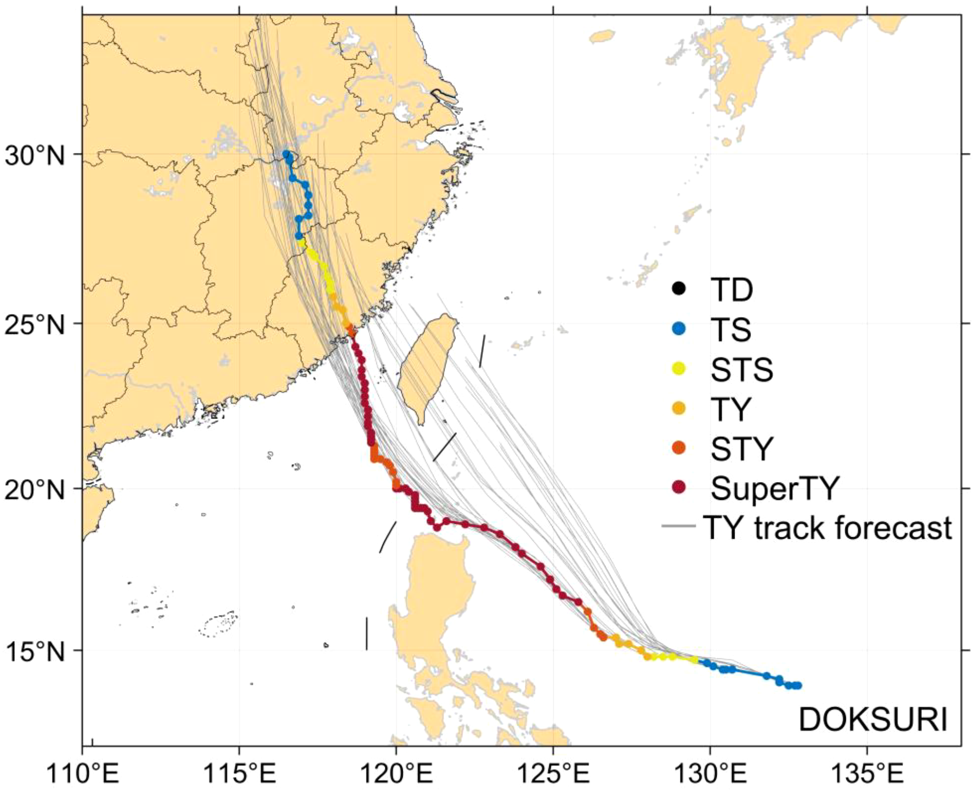
Intensity change and track forecast of Typhoon “Doksuri”.
4 Designed ship route
Ship A is a bulk carrier with a length of 230 m, a width of 38 m, and a draft of 17.8 m. It was in ballast condition for this voyage. The starting port was Gladstone in Australia, and the destination port was Putian Port in Fujian Province, China. The planned route started from Gladstone, sailed northward along the Great Barrier Reef waters, passed through the Coral Sea, the Solomon Sea, and the Bismarck Sea, then sailed northwestward, passed through the eastern waters of the Philippines, entered the Taiwan Strait after passing through the Bashi Channel, and finally arrived at Putian Port (as shown by the blue line in Figure 3). During the actual voyage, around July 23, the ship sailed to the eastern waters of the Philippines. Affected by Typhoon “Doksuri,” the route was adjusted to sail near the coast, and the ship stopped sailing. It resumed sailing after the typhoon passed. The black line in Figure 3 is the actual route.
Figure 3
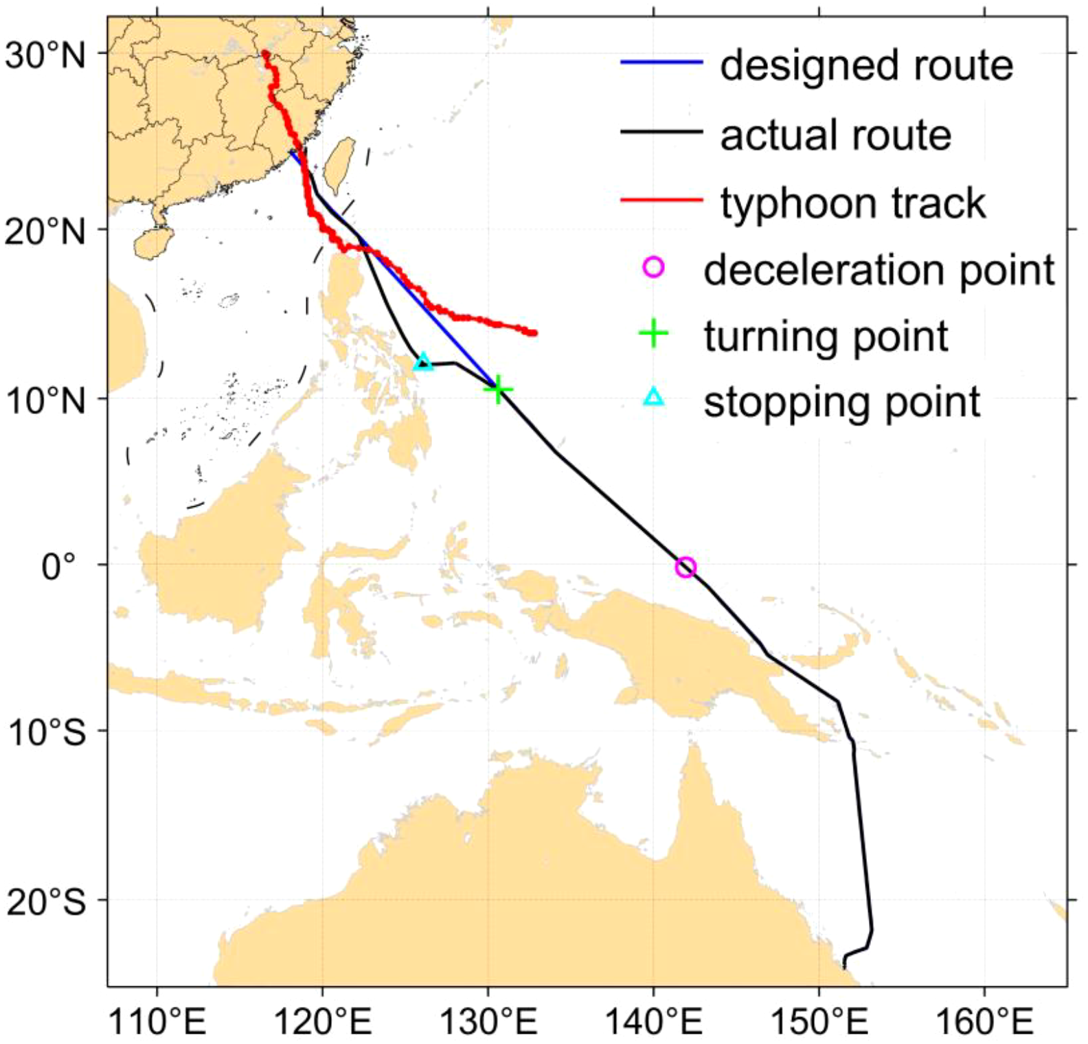
Designed route of ship A from Australia to Fujian, China.
5 Analysis of ship typhoon—avoidance strategies
5.1 Decelerated and sailed straight
Around the 17th, the ship had passed through the Great Barrier Reef and entered the Bismarck Sea. According to the 12h interval wind field forecast results starting from the 21st (Figure 4), a tropical cyclone might form in the waters ahead of the ship’s route in the later period. The route would pass through the southwestern part of the cyclonic wind field convergence area. If the ship sailed into the high-wind and high-wave range of the typhoon, it would be severely affected by crosswinds and crosswaves. Based on the prediction results and combined with the impact time of the severe weather, the Meteorological Routeing Centre of the China Meteorological Administration suggested that the ship decelerate and sail straight to reduce the possible navigation risks caused by the later typhoon formation and to obtain more time and space conditions for route adjustment. Starting from the daytime of the 18th, Ship A accepted the suggestion of the Meteorological Routeing Centre and began to decelerate, reducing the speed to about 8.5 kn.
Figure 4
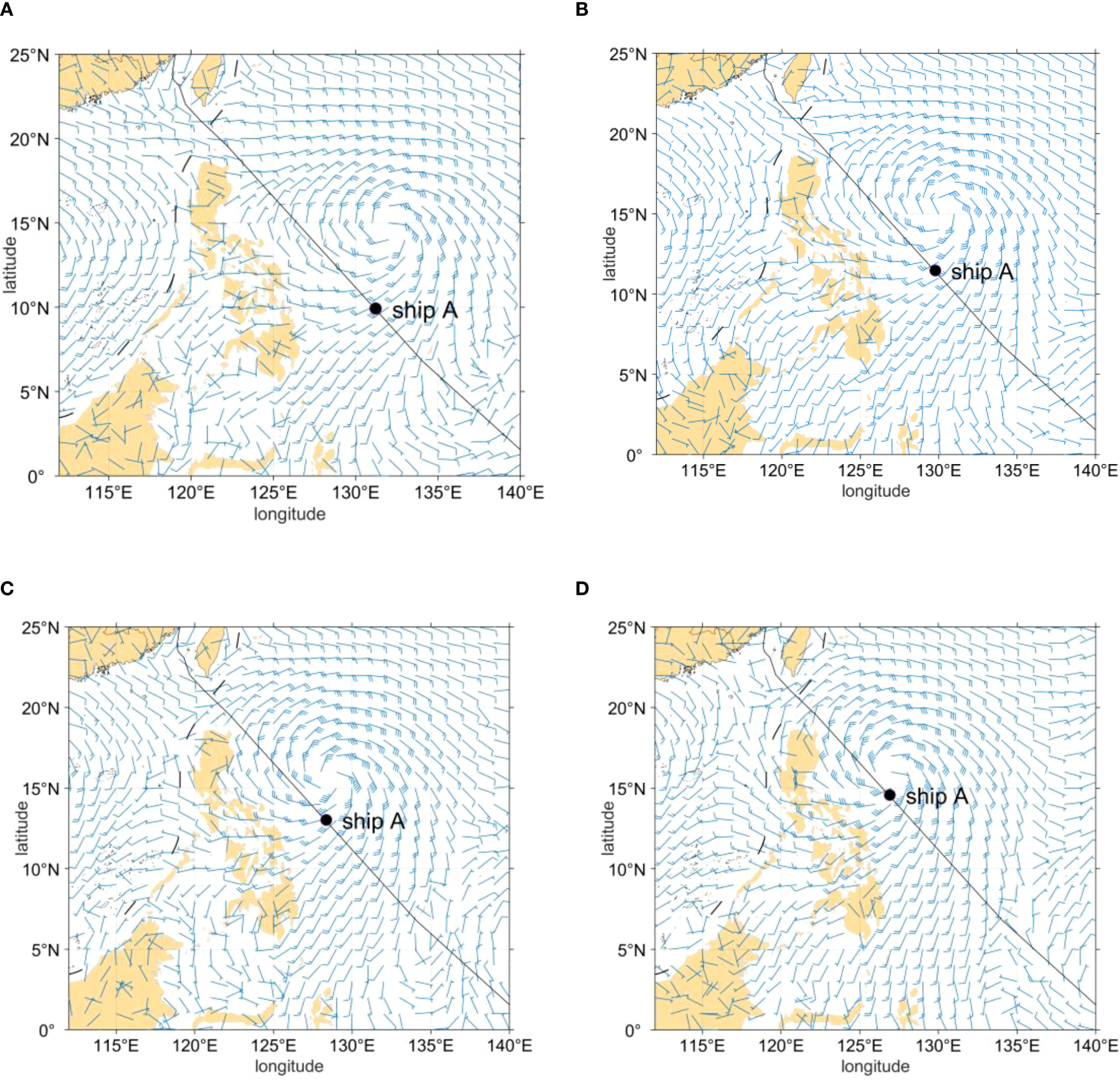
Forecast position of Ship A and wind field forecast. (A) 12UTC on 21st (B) 00UTC on 22th (C) 12UTC on 22th (D) 00UTC on 23th.
5.2 Front-crossing typhoon avoidance
On July 21, after Typhoon “Doksuri” was numbered, it was predicted that it would move northwestward in 72h and then turn northwestward and might pass by the north of Taiwan after 120h. In the forecast at 00:00 on the 22nd, the typhoon’s track was adjusted southward, and it was predicted that it would make landfall on Taiwan Island and enter the Taiwan Strait. As the ship sailed, the typhoon track forecast continued to adjust southward, and the position of the ship gradually approached the typhoon later (Figure 5).
Figure 5
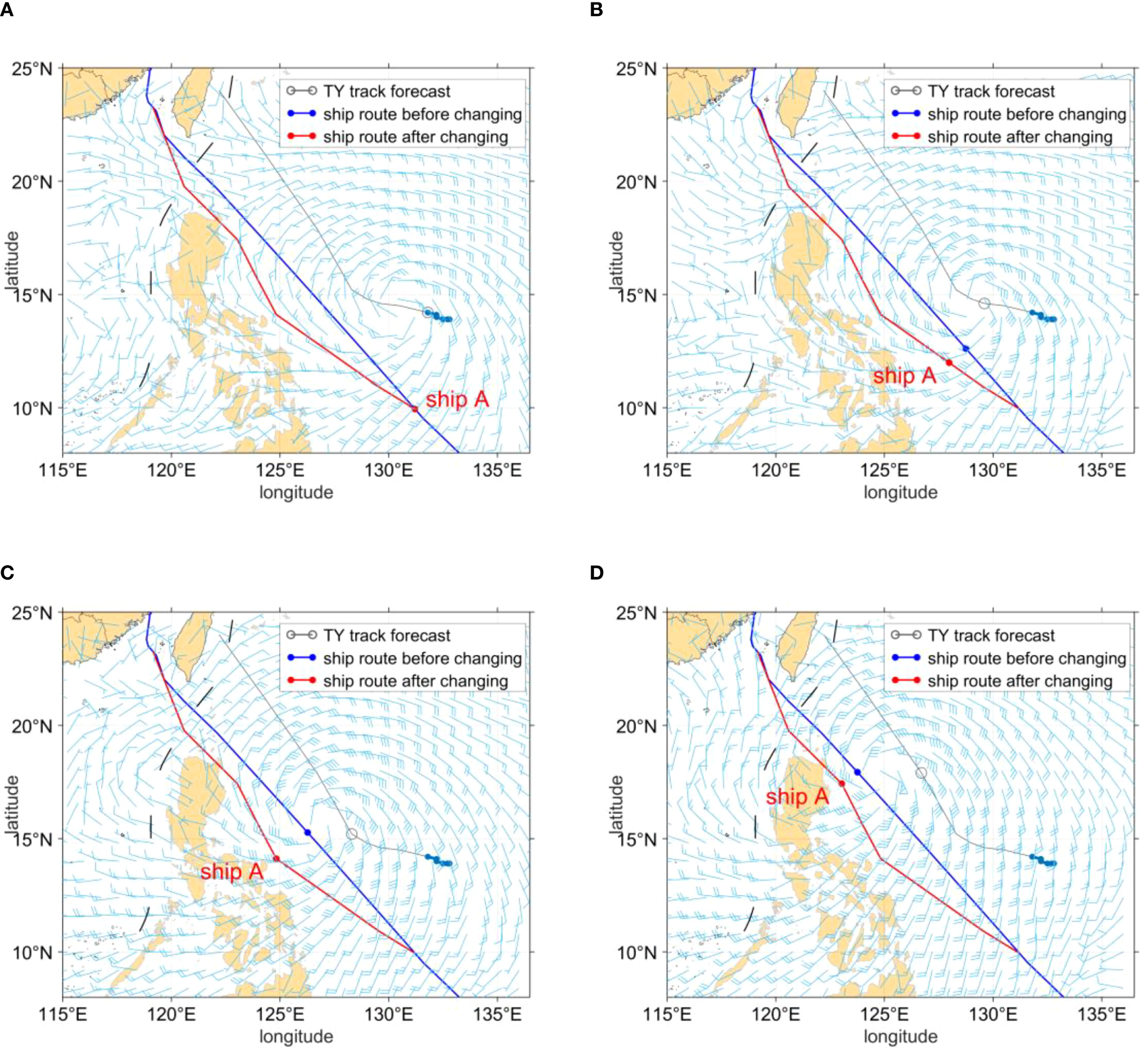
Forecast positions of the ship and typhoon track forecast before and after the route change. (A) 00UTC on 22th (B) 00UTC on 23th (C) 00UTC on 24th (D) 00UTC on 25th.
Facing the continuous changes in the typhoon track, the Meteorological Routeing Centre used the typhoon-avoidance algorithm in real-time operations, constructed a navigable route network, and combined it with the ship’s wave-resistance ability to calculate the typhoon-avoidance route. It was suggested that Ship A adopt a typhoon-avoidance strategy by departing early starting on the 22nd, adjusting its route to sail northward along the east coast of the Philippines, and then turning westward after passing through the southern part of the Balintang Channel. This adjustment significantly increased the Distance of Closest Point of Approach (DCPA) between the ship and the typhoon from 101 to 183 n mile. There were also obvious changes in the wind and waves the ship encountered before and after the route adjustment. In the original route, Ship A would encounter winds of up to level 11 and a maximum significant wave height close to 9 m from the 23rd. After the route adjustment, the maximum wind speed decreased to level 8, and the maximum wave height was about 6.5 m (Figure 6). Front-crossing typhoon avoidance reduced the impact of wind and waves on the ship and significantly improved navigating safety.
Figure 6
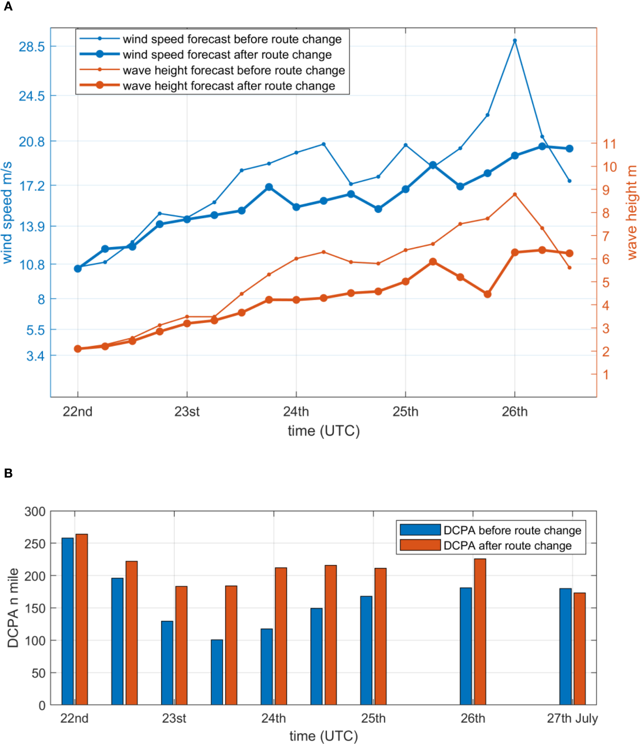
Comparison of wind and wave forecasts (A) and ship-typhoon distance before and after the ship route change (B).
5.3 Parked and drifted
As of 06:00 UTC on the 23rd, the center of Typhoon “Doksuri” was located about 460 n miles east of Manila, the Philippines, with maximum sustained winds of Beaufort Force 10 near its center. The seven-level wind radius extended 160–180 n miles. It was forecast that the typhoon would move west-northwest at a speed of about 6 knots, approach the southeast coast of Taiwan, gradually strengthen in intensity, and reach the super typhoon level (levels 15–16) at peak intensity.
The further southward adjustment of the typhoon forecast track posed greater challenges to the ship’s typhoon avoidance. At this time, Ship A was located in the seven-level wind circle in the southwest direction of “Doksuri.” According to the analysis of the ship’s movement, typhoon track, and wind and wave forecast (Figures 7A–D), it was predicted that the ship would gradually approach the typhoon. At 00:00 on the 25th, the ship would be located about 100 n miles southwest of the severe typhoon (Figure 7C), with an average wind force of level 9–10 and a wave height of 7–9 m (Figure 8). This ship–typhoon distance and wind–wave conditions would have a serious impact on the ship’s navigation and might even pose a fatal threat. The Meteorological Routeing Centre adjusted the navigation strategy of Ship A again and suggested that the ship sail westward from its current position and stop and drift at an appropriate position near the coast of the Philippines. Ship A stopped sailing at 20:00 UTC on 23 July 2023, at coordinates (12°0.4’N, 125°50.0’E) in the eastern waters of the Philippines.
Figure 7
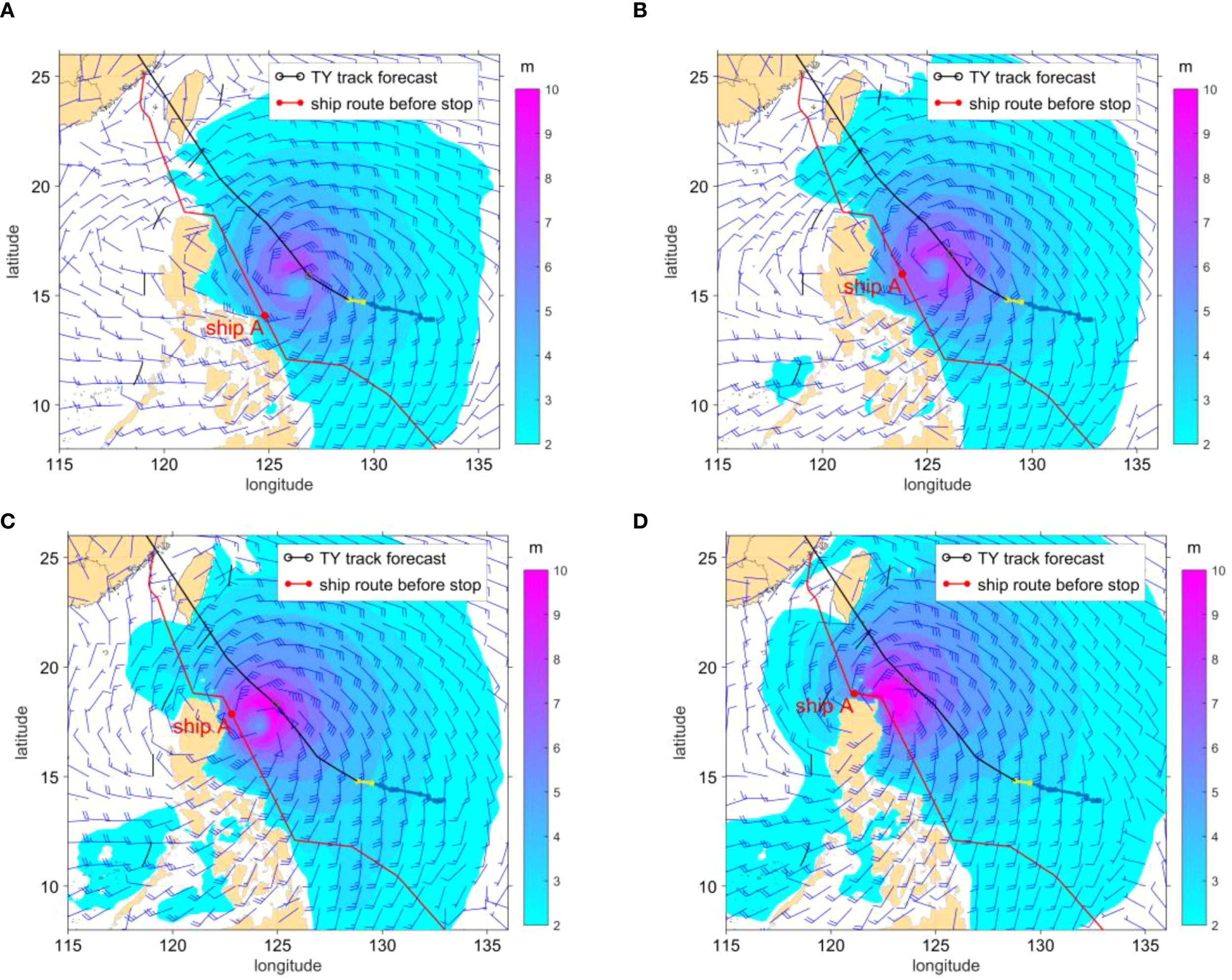
Typhoon wind and wave forecast and ship forecast position map. (A) 00UTC on 24th (B) 12UTC on 24th (C) 00UTC on 25th (D) 12UTC on 25th.
Figure 8
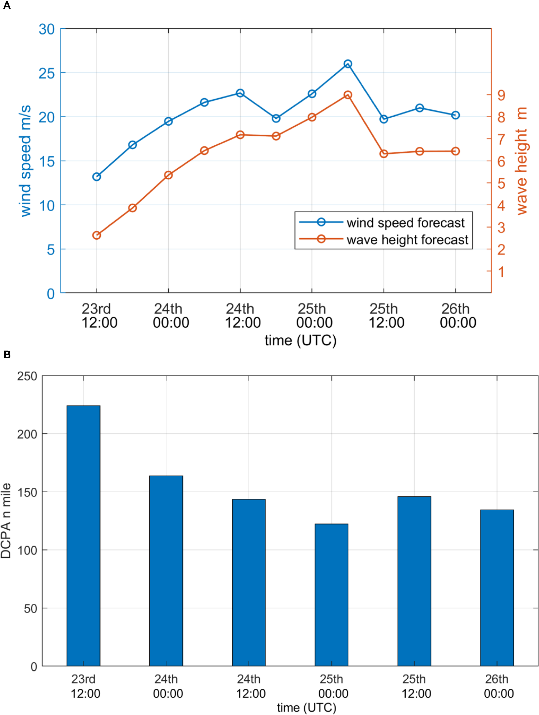
Comparison of wind and wave forecasts and ship–typhoon distance. (A) wind and wave forecasts (B) Ship - typhoon distance.
5.4 Resumed sailing
The general conditions for a ship affected by a typhoon to resume sailing are that the typhoon and the ship maintain a sufficient distance, and the impact of wind and waves has weakened to a level that the ship can bear.
On the morning of July 25, the super typhoon was located over the ocean northeast of Luzon Island in the Philippines, with a maximum wind force of level 17 near the center. The forecast showed that the typhoon would move northwestward at a speed of about 11 knots, pass through the Luzon Strait, and enter the South China Sea. At this time, Ship A was anchored on the sea about 340 n miles southeast of the typhoon center. After comprehensive calculations by the Meteorological Routeing Centre, if the ship resumed sailing at this time, the ship–typhoon distance would gradually increase to more than 400 n miles, which was a relatively safe risk distance. The wind and wave forecasts showed that the wind force on the route from the 25th to the 26th would be level 6–7, and the wave height would be 3–4 m. The wind and waves showed a gradual decreasing trend over time, which met the conditions for the ship to resume sailing. Ship A resumed sailing at 12:00 UTC on 25 July 2023, at coordinates (12°4.3’N, 126°5.6’E) after the typhoon passed.
6 Discussions and conclusions
In the case of this paper, the originally planned voyage of Ship A was about 3,800 n miles, and the estimated sailing time was 15 days. Affected by Typhoon “Doksuri” (the fifth typhoon in 2023) during the actual voyage, Ship A took typhoon-avoidance measures. The route adjustment led to an increase of about 100 n miles in the actual voyage. From 20:00 on July 23 to 12:00 on the 25th, the ship stopped sailing for nearly 40h in the waters east of the Philippines, which extended the entire sailing time to nearly 18 days. With the professional support of the Meteorological Routeing Centre of the China Meteorological Administration, Ship A adopted a series of strategies such as decelerating straight ahead, front-crossing typhoon avoidance, parking and drifting, and resuming sailing in time, which effectively reduced the potential threat of the typhoon to navigation safety and ensured the safe arrival of the ship at the port.
Ships navigating typhoon-prone regions must prioritize mitigating wind–wave hazards. Through Ship A’s typhoon-avoidance case study, this research demonstrates the effectiveness of the typhoon-avoidance strategies in ensuring vessel and cargo safety, underscoring the critical importance of meteorological routing services. While route adjustments increased voyage distance and duration, these compromises remain justifiable given the severe consequences of typhoon exposure.
Two primary limitations constrain the effectiveness of the proposed typhoon avoidance strategy. First, it has heavy reliance on the accuracy of short-term typhoon track and intensity forecasts, as path prediction errors exceeding 20% may substantially compromise route optimization outcomes. Additionally, the current model inadequately addresses dynamic operational parameters, particularly ignoring the impact of ship loading variations (e.g., draft adjustments) on wave resistance and navigational safety.
Future research should prioritize four interconnected directions: (1) Enhancing typhoon forecast accuracy through multi-model ensemble techniques and assimilation of real-time satellite/sea-surface data; (2) Integrating higher-resolution (igher- × 0.05°) meteorological-oceanographic coupled datasets to improve typhoon avoidance models’ responsiveness to mesoscale typhoon systems; (3) Developing a dual-objective optimization framework balancing safety and energy efficiency by incorporating real-time ship loading dynamics and wave resistance parameters; (4) Strengthening the cross-disciplinary cooperation to provide more comprehensive and efficient ship routing services.
Statements
Data availability statement
The original contributions presented in the study are included in the article/supplementary material. Further inquiries can be directed to the corresponding authors.
Author contributions
ZZ: Writing – original draft, Writing – review & editing, Conceptualization, Methodology. CZ: Methodology, Writing – review & editing. HZ: Writing – review & editing. YG: Writing – review & editing. YC: Writing – review & editing. GW: Writing – review & editing. YD: Writing – review & editing. TL: Writing – original draft, Writing – review & editing.
Funding
The author(s) declare financial support was received for the research and/or publication of this article. This work was supported by the National Key Research and Development Project of China (Grant No. 2023YFC3107900).
Conflict of interest
Authors GW and YD were employed by the company Beijing Global Metroute Technology Co., Ltd.
The remaining authors declare that the research was conducted in the absence of any commercial or financial relationships that could be construed as a potential conflict of interest.
Generative AI statement
The author(s) declare that no Generative AI was used in the creation of this manuscript.
Any alternative text (alt text) provided alongside figures in this article has been generated by Frontiers with the support of artificial intelligence and reasonable efforts have been made to ensure accuracy, including review by the authors wherever possible. If you identify any issues, please contact us.
Publisher’s note
All claims expressed in this article are solely those of the authors and do not necessarily represent those of their affiliated organizations, or those of the publisher, the editors and the reviewers. Any product that may be evaluated in this article, or claim that may be made by its manufacturer, is not guaranteed or endorsed by the publisher.
References
1
Anggani G. R. Arfianto A. Z. Arleiny A. Setiawan B. T. (2023). Ship collision realtime early warning system based on automatic identification system (AIS) data. Indones. J. Eng. Res.3, 18–23. doi: 10.11594/ijer.v3i1.42
2
General Administration of Quality Supervision, Inspection and Quarantine of the People’s Republic of China and Standardization Administration of China (2006). Grade of tropical cyclones: GB/T 19201 - 2006 (Beijing: China Standards Press).
3
Huang Y. X. Ding X. Y. Zhang Y. N. Yan L. M. (2022). T_GRASP: optimization algorithm of ship avoiding typhoon route. J. Quantum Computing4, 85–95. doi: 10.32604/jqc.2022.031436
4
Liu D. G. Xu D. H. Wu Z. L. (2005). Risk degree assessment model of navigating ship on heavy sea. J. Traffic Transportation Eng.5, 83–86. doi: 10.3321/j.issn:1671-1637.2005.03.018
5
Mannarini G. Coppini G. Oddo P. Pinardi N. (2019). A prototype of ship routing decision support system for an operational oceanographic service. TransNav Int. J. Mar. Navigation Saf. Sea Transportation7, 53–59. doi: 10.12716/1001.07.01.06
6
United Nations Conference on Trade and Development (UNCTAD) (2023). Review of maritime transport 2023: Towards a green and just transition (United Nations). Available online at: https://digitallibrary.un.org/record/4042151/files/UNCTAD_RMT_2023-EN.pdf.
7
Wang L. Lu Y. Zhao H. K. (2023). Analysis of temporal and spatial characteristics of typhoon disasters and construction of evaluation model. J. Catastrophology38, 187–194.
8
Wang J. Zhu S. Y. Wang G. Z. Wang M. R. (2021). Route optimization of ship avoiding typhoon under meteorological uncertainty. J. Dalian Maritime University 47(2)56-62, 70. doi: 10.16411/j.cnki.issn1006-7736.2021.02.007
9
Wu L. C. Wen Y. Q. Peng S. Q. Zhang J. F. Xiao C. S. (2013). Optimizing the routing of ship’s tropical cyclone avoidance based on the numerical forecasts. Nat. Hazards69, 781–792. doi: 10.1007/s11069-013-0729-4
10
Wu L. Wen Y. Wu D. Zhang J. Xiao C. (2014). Safe - economical route model of a ship to avoid tropical cyclones using dynamic forecast environment. Natural Hazards Earth System Sci. Discussions2, 4907–4945. doi: 10.5194/nhessd-2-4907-2014
11
Zhang H. Rao Y. K. Liu T. Zhao W. Cao Y. N. Guo Y. Y. (2023). Optimizing the routing of ship’s typhoon avoidance - a case study of Typhoon Doksuri (2305). J. Mar. Meteorology43, 32–39. doi: 10.19513/j.cnki.issn2096-3599.2023.04.004
12
Zhang J. F. Wang X. O. Liu Y. S. (2016). Dynamic optimization of ship typhoon avoidance routeing in China offshore waters. Navigation China39, 45–49. doi: 10.3969/j.issn.1000-4653.2016.02.011
13
Zhang W. J. Wei S. Y. Li Q. Liu D. G. Liu Z. J. (2010). Multilevel decision method of ship’s tropical cyclone avoidance route using multisource track forecast. J. Traffic Transportation Eng.10, 122–126. doi: 10.19818/j.cnki.1671-1637.2010.03.021
Summary
Keywords
tropical cyclone, weather routing, typhoon avoidance, Doksuri, bulk carrier
Citation
Zhang Z, Zhang C, Zhang H, Guo Y, Cao Y, Wu G, Dong Y and Liu T (2025) Analyses of Ship A avoiding the influence caused by typhoon “Doksuri”. Front. Mar. Sci. 12:1661860. doi: 10.3389/fmars.2025.1661860
Received
08 July 2025
Accepted
10 September 2025
Published
01 October 2025
Volume
12 - 2025
Edited by
Weihao Ma, Wuhan University of Technology, China
Reviewed by
Zhaoyang Ma, Zhejiang University, China; Tianfu Lu, Wuhan University of Technology, China
Updates
Copyright
© 2025 Zhang, Zhang, Zhang, Guo, Cao, Wu, Dong and Liu.
This is an open-access article distributed under the terms of the Creative Commons Attribution License (CC BY). The use, distribution or reproduction in other forums is permitted, provided the original author(s) and the copyright owner(s) are credited and that the original publication in this journal is cited, in accordance with accepted academic practice. No use, distribution or reproduction is permitted which does not comply with these terms.
*Correspondence: Chengbao Zhang, zhangcb@cma.cn; Tao Liu, liut@cma.cn
Disclaimer
All claims expressed in this article are solely those of the authors and do not necessarily represent those of their affiliated organizations, or those of the publisher, the editors and the reviewers. Any product that may be evaluated in this article or claim that may be made by its manufacturer is not guaranteed or endorsed by the publisher.