Abstract
Deep-sea mining management, scientific research, and public discourse have largely focused on polymetallic nodule extraction from abyssal plains. However, there is growing commercial interest in nodules on and around seamounts, with exploration and testing underway in the Pacific Ocean. Increasing documentation of nodules-seamount habitats and co-occurrence with cobalt-rich ferromanganese crusts refutes the misconception that nodules occur only in abyssal plains. This also challenges the conventional management framework that separates these mineral resources into distinctly different habitats. Nodule exploitation is poised to begin soon in both environments, but under the rubric developed for abyssal plains alone. Existing and developing guidance based on the simplified resource-habitat framework is likely inadequate in addressing where nodule fields are associated with seamounts. Seamounts are ecologically significant and vulnerable features, often linked to islands as part of volcanic chains, and embedded in dynamic oceanographic systems that can amplify mining impacts. Sustainable management will require an integrated and adaptive approach, including critical reassessment of Regional Environmental Management Plans in international waters and complementary frameworks in national waters, as nodule mining moves beyond abyssal plains and onto seamounts.
1 Introduction
The deep sea is the least explored environment on Earth but is increasingly being considered for mineral resource extraction. The International Seabed Authority (ISA) is an autonomous body, established under the United Nations Convention on the Law of the Sea (UNCLOS)1 and the 1994 Agreement on Implementation2, responsible for managing deep-sea mining (DSM) and protecting the seafloor as the common heritage of humankind in Areas Beyond National Jurisdiction (ABNJ). The ISA classifies DSM into three types, each a mineral resource associated with one such distinct habitat that it describes as substantially different from the others (ISA, 2006, Figure 1a):
Figure 1
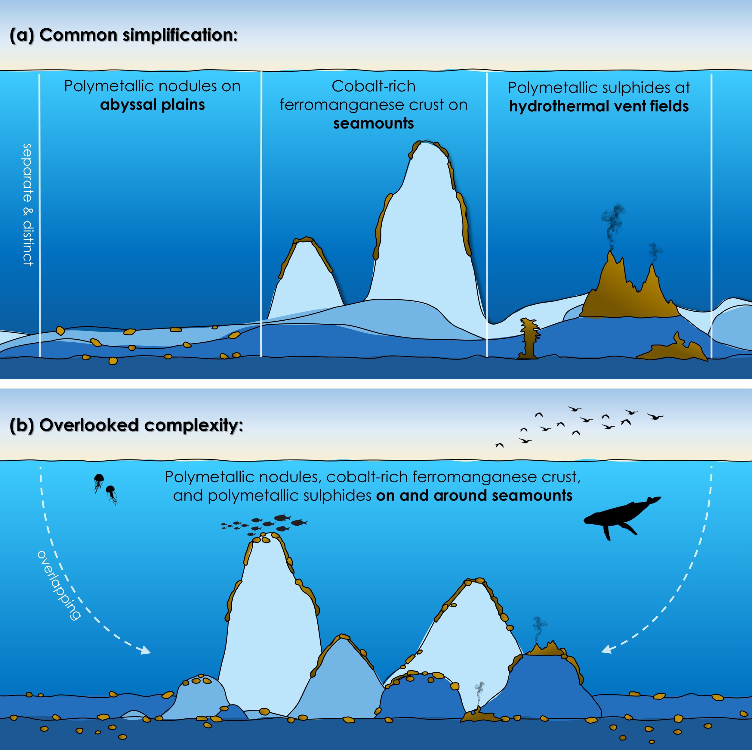
Conceptual diagram of deep-sea mining mineral resources showing (a) the three habitats commonly depicted as separate and distinct (and barren) categories, (b) along with their often-overlooked overlapping distributions (and biodiversity).
-
Polymetallic nodules on abyssal plains,
-
Cobalt-rich ferromanganese crusts on seamounts, and
-
Polymetallic sulphides at hydrothermal vent fields.
Expanding on this classification, nodules are commonly described as potato-sized mineral concretions (rocks), associated with vast, flat deep-sea areas. Crusts are thin deposits that paved exposed rocks, primarily on steep volcanic submarine mountains, and to a lesser extent, ridges and island flanks. Sulphides are deposits at tectonically active sites, forming chimney- or mound-like mineral structures along mid-ocean ridges and back-arc basins (ISA, 2006; Hein et al., 2013).
A substantial body of research has identified several general DSM impact pathways that are widely applicable across resource types and regions. Anticipated impacts are long-lasting, potentially irreversible, and include: removal of the substratum (that supports benthic organisms and assemblages) along with sessile and sedentary species—many of which are unique to the mineral resource; release of sediment plumes from mining vehicles and surface vessels, which may disperse widely and alter both adjacent and distant habitats; physical and/or chemical transformation of the seafloor, thereby inhibiting recolonization; release of toxins such as heavy metals both at the seabed and in plumes; and acoustic and light pollution from machines, pumps, and ships (Levin et al., 2020; Amon et al., 2022; Weaver et al., 2022; Williams et al., 2022; Yao et al., 2025). While plume effects are relevant to all mineral resources, nodule mining on soft sediments is expected to generate the most extensive dispersion. The island-like nature and elevated productivity of seamounts and hydrothermal vents raise additional concerns around disrupted ecological connectivity for resident and migratory populations (e.g., cetaceans and chondrichthyans) (e.g., Gollner et al., 2017; Thompson et al., 2023; Judah et al., 2025). Cumulatively, DSM impacts may interact with existing ocean stressors—including warming, acidification, deoxygenation, and overfishing—further threatening deep-sea biodiversity and ecosystem function. These anticipated general impacts notwithstanding, a clear understanding of site- and activity-specifics will be fundamental to sustainable DSM environmental management moving forward.
The simplified three-option resource-habitat framework (Figure 1a)—distinguishing seamounts, vents, and abyssal plains—underpins DSM industry development, environmental assessments, science to guide management decisions, and public understanding. However, the deep sea is a dynamic, four-dimensional environment of diverse, interconnected and overlapping habitats shaped by complex geological, oceanographic, and biological processes (Figure 1b). Here, we examine how the ISA and States frame proposed exploitation, the growing evidence of habitat overlap and misconceptions, and consider implications for environmental management.
2 The current state of DSM environmental management
ISA-led efforts remain the most extensive in terms of DSM governance and regulatory development. To date, it has issued DSM exploration contracts covering more than 1.5 million km² of ABNJ in the Pacific, Indian, and Atlantic Oceans (Smith et al., 2020). Currently, there are three sets of exploration regulations to manage activities, each specific to one mineral resource (ISA, 2010, 2012, 2013), and draft exploitation regulations (ISA, 2025a). According to the draft regulations, amongst other things, DSM cannot proceed until the relevant Regional Environmental Management Plan (REMP) is adopted (ISA, 2025a). REMPs are a key component of marine environmental sustainability, intended to equip the ISA, contractors, and sponsoring States with area-based and other management tools to support informed decisions that balance resource development with environmental protection3.
The ISA Secretariat convenes workshops to prepare draft elements for inclusion in the REMPs (ISA, 2019). These workshops follow the resource-habitat framework, which assumes that each mineral resource is confined to distinct deep-sea habitats and environmental conditions (Figure 1a). When multiple mineral resources occur in a region, participants and objectives are separated, compartmentalizing area-based management tool discussions, cumulative impact assessments, etc. (e.g., ISA, 2020; Zhou et al., 2024). To date, only one REMP is in effect, for nodule mining in the Clarion-Clipperton Zone (CCZ) (ISA, 2011), while three others are in development: the Northern Mid-Atlantic Ridge (sulphides), the Indian Ocean (nodules and sulphides), and the Northwest Pacific (nodules and crust)3. However, these REMPs preceded the ISA Council’s adoption of a standardized procedure in July 2025 for their development, establishment, and review (ISA, 2025b), and were considered unfinished in the absence of such guidance (ISA, 2024).
Within their national jurisdiction, States can proceed without regulatory approval from the ISA but are encouraged to apply at least equivalent standards, in line with Article 208(3) of UNCLOS4. However, DSM environmental management in Exclusive Economic Zones (EEZs) varies widely among jurisdictions. While some countries have imposed national moratoria or precautionary bans5 (e.g., Canada6), others are actively moving towards DSM and developing environmental management plans. For example, Japan has national goals7 and is conducting surveys and equipment testing8, the USA is developing a permitting process9 and is collecting regional environmental information10, while the Cook Islands has already issued exploration permits for nodules and is nearing completion of a REMP11. Regardless of their stage of progress, national and industry environmental management planning uses the classification of three DSM types from the outset (Figure 1a).
Of the three types, nodule exploitation from abyssal plains, especially in the central Pacific, has long been at the center of DSM (Lodge et al., 2014). The CCZ currently accounts for 90% of all ISA nodule exploration contracts12 and the Cook Islands efforts in their EEZ west of the CCZ are the most advanced national operation13. As such, abyssal plain nodules have greatly influenced the development of overall DSM standards (e.g., draft baseline data guidelines; ISA, 2022) and narratives (e.g., proponents often depict or emphasize the perceived homogeneity and barrenness of the central Pacific abyssal plains to suggest low environmental impacts; Smith et al., 2020; Tunnicliffe et al., 2025). However, DSM prospecting is broadening. In addition to the central Pacific, nodules–and mining interests–are being identified in other regions across the global ocean, in national and international waters, including habitats beyond abyssal plains.
3 Nodules on and around seamounts
3.1 Worldwide
An increasing number of studies are reporting nodule occurrences on and around seamounts and seamount-like features. Nodules have been found both on the surface and buried in sediments, from surrounding plains to peaks. Several studies indicate a positive correlation between nodule density and seamount occurrences (e.g., Mukhopadhyay and Ghosh, 2010), while others document nodules and crusts coinciding (even alongside hydrothermal vent sulphides, e.g., González et al., 2014) (Figure 1b). Examples include:
-
Indian Ocean (Sharma and Kodagali, 1993; Mukhopadhyay and Ghosh, 2010),
-
Western Atlantic (Galvez et al., 2021a, b),
-
Eastern Atlantic (González et al., 2014; Yeo et al., 2019),
-
North Pacific (Mel’nikov et al., 2016),
-
Northwest Pacific (see below),
-
Western Pacific (Machida et al., 2016; 2021a, b, Zhou et al., 2022),
-
Central Pacific (where nodules in the CCZ are most abundant in areas adjacent to seamounts; Kim et al., 2012; Kuhn et al., 2017; Kuhn and Rühlemann, 2021), and
-
South Pacific, including the Cook Islands and American Samoa (Hein et al., 2015; Browne et al., 2023).
Global distribution models of nodule and crust formation further corroborate these records, showing substantial spatial overlap (e.g., Miller et al., 2018; Dutkiewicz et al., 2020; Guo et al., 2022; Yao et al., 2025). These records and models demonstrate that mineral resources occur, and sometimes categorically co-occur14, across diverse habitats. This challenges the fundamental claim that nodule environments are distinct from those of crusts (and sulphides) (ISA, 2006).
Beyond spatial overlap, the distinction between nodules and crusts is further blurred by shared similarities in formation and composition. Seamounts provide the hard substrates required for crust formation. They also shed rock fragments, animal skeletons, and other biogenic materials that serve as abundant nuclei for nodule formation, particularly on archipelagic aprons, such as in the Northwest Pacific (Li et al., 2021; Yao et al., 2024). Some nodules are exclusively hydrogenetic, forming over long timescales similar to crusts, and co-occur with crusts on seamounts sharing similar metallic compositions and precipitation mechanisms (Hein et al., 2013; Guo et al., 2022). Further complicating categorical distinctions, crusts can form in nodule-like shapes (e.g., Yang et al., 2023), while nodules can become cemented together by a crust pavement (e.g., Hein et al., 2012), or there is no clear distinction and both are referred to as “nodules” (Guo et al., 2022).
3.2 A closer look at the Northwest Pacific ISA area
The Northwest Pacific Ocean has a high density of significant geological structures, including seamounts, islands, and the Mariana Trench (Figure 2). The seamounts and surrounding seafloor here are the oldest oceanic crust on Earth, dating back over 172 million years (Ren et al., 2022). The seamount complex is also among the deepest, tallest, largest, and densest (i.e., over 200 seamounts covering 6 vertical km, some over 200 km across) (e.g., Wessel et al., 2010; Du Preez et al., 2023). These geologically unique features shape regional ecology by influencing ocean currents, boosting biomass, and enhancing biodiversity, as well as vertical and horizontal connectivity (Leitner et al., 2020; Du Preez et al., 2023; more on this topic in the Discussion). As such, the Magellan, Marcus-Wake, and Marshall seamounts in the ABNJ (Figure 2) meet the criteria for designation as Ecologically or Biologically Significant Areas (ISA, 2020; Du Preez et al., 2023).
Figure 2
![Map of the Northwest Pacific showing seamount groups, [mining blocks,] and nodule distribution. Areas with nodule blocks are highlighted in red with stripes, crust blocks in orange, nodules in red dots, and buried nodules in red squares. Oceanic features like the Mariana Trench and various basins are labeled. An inset [photo shows the co-occurrence of crust and nodules on the plateau] of Vogt Guyot, and an inset map of the Pacific Ocean shows the International Seabed Authority area. A legend explains symbols for seamounts, [mining blocks,] and nodule records.](https://www.frontiersin.org/files/Articles/1666150/xml-images/fmars-12-1666150-g002.webp)
Map of polymetallic nodules within the Northwest Pacific seamount complex, International Seabed Authority (ISA) area. Data shown are published records of seamounts and Magellan, Marshall, and Marcus-Wake seamount groups (ISA, 2020; Du Preez et al., 2023; Wang et al., 2024), 100 km buffer around seamounts (i.e., related to seamount-associated eddies and aprons as well as ISA buffers; see text for more details), ISA exploration blocks for nodules (red polygons) and cobalt-rich ferromanganese crust (orange polygons; ISA, 2020), and nodule records (points; Dutkiewicz et al., 2020; Yang et al., 2020; Li et al., 2021; Deng et al., 2022; Ren et al., 2022). Also shown: seamounts and islands with nodules and of interest (red triangles). Photo inset shows example of crust and nodule field co-occurring on the plateau of Vogt Guyot (credit: Ocean Exploration Trust and the National Oceanic and Atmospheric Administration). Basemap from Global Multi-Resolution Topography15.
Nodules are widespread throughout the complex of seamounts (Figure 2: red symbols). They are abundant in soft sediments surrounding and between the seamounts, at depths of up to 6130 m, across the archipelagic aprons that can span over 100 km (Li et al., 2021; Yao et al., 2024). Nodules are also found on the seamount slopes and summits at depths of 1500 m and shallower (Hein et al., 2013; Mel’nikov et al., 2016; Hein et al., 2020; Joo et al., 2020; Yang et al., 2020; Li et al., 2021; Deng et al., 2022; Ren et al., 2022; Zhang et al., 2023; Deng et al., 2024; Nakamura et al., 2024; Wang et al., 2024; Xu et al., 2024; Yao et al., 2024). The unique environmental conditions within the seamount complex have also led to the formation of the thickest and most extensive crusts globally (part of the “Prime Crust Zone”; Hein et al., 2013). These crusts are abundant between 400 and 4000 m (Ren et al., 2022). The nodule and crust deposits combined make the region of high mining interest, including the area of ISA contracts and the EEZs of the USA (Guam, the Mariana Islands, Wake Island16) and Japan (Minamitori/Minamitorishima Island17) (Figure 2).
The ISA has issued four exploration contracts for crusts and one for nodules (to Japan, Russia, the Republic of Korea, and China), and has designated corresponding Reserved Areas for both mineral types (intended for future DSM by developing nations) within approximately two million square kilometers of the Northwest Pacific. Hereafter, contract and Reserved Areas are collectively referred to as “blocks” (Figure 2: orange for crust blocks, red for nodule blocks). The two types of blocks are intermixed geographically, concentrated around seamounts, and, in most cases, co-occur on the same features—spanning the summits, flanks, and bases (e.g., Figure 2: inset of Vogt Guyot). Crust blocks, which collectively cover ~15,000 km2, surround nearly all the 30 shallowest seamount summits in the region (i.e., defined here as shallower than 2,500 m depth; Hein et al., 2009; ISA, 2020). In contrast, nodule blocks total 150,000 km2—as permitted under ISA regulations (ISA, 2012, 2013). These nodule blocks are centered within the Magellan and Marcus-Wake seamount groups, where they overlap with or border seamount aprons, foothills, and lower flanks in all directions (Figure 2: seamount ecosystem boundaries based on conservative delineations by ISA, 2020; Du Preez et al., 2023; Wang et al., 2024). The nodule block areas between seamounts are well within the aprons and dynamic flow regimes of the larger seamount complex. These include the 100 km mesoscale eddies that concentrate and transport water and material between seamounts (Jiang et al., 2021; Nagai et al., 2021; Xie et al., 2022b). Notably, the Saipan, Pigafetta, and Northwest Pacific basins cover the majority of the area (ISA, 2020; Figure 2), but there are few records of nodules and no contract blocks here; nodule prospectors have shown little interest in these abyssal plains, especially in contrast to the seamounts (Figure 2).
4 Discussion: seamount environmental considerations and potential oversight gaps
4.1 Seamount mining redefined
Under the narrow resource-habitat framework, mining on and around seamounts has often been viewed as unlikely or distant due to the significant technological and environmental challenges associated with crust DSM (Xie et al., 2022a). Crust extraction requires cutting, crushing, and removing rock on steep, rugged terrain (Xie et al., 2022a). However, seamount geomorphology is highly diverse, and many features—such as aprons, slopes, terraces, cones, plateaus, especially on older guyots—can be gently sloped or flat, sedimented, and covered in nodules (Yeo et al., 2019; Yang et al., 2020; Wang et al., 2024; Yao et al., 2024; Figure 2: Vogt Guyot). On these seamount features, nodules can be collected directly from the sediment, avoiding many of the technical barriers associated with crust extraction.
Nodule DSM on or near seamounts and islands now appears to be advancing more rapidly than other forms of DSM. Several States have recently announced imminent plans for test and/or commercial-scale operations in ABNJ and their EEZs. For example: (i) the Beijing Pioneer Hi-Tech Development Corporation Ltd. (China) planned to begin test nodule extraction on the lower slope of Magoshichi-no-Hoshi Seamount in ABNJ in 202518 (Northwest Pacific; Figure 2); (ii) the Japan Agency for Marine-Earth Science and Technology is commercially targeting nodules near Minamitori Island and its surrounding seamounts in their EZZ in early 202619 (Northwest Pacific; Figure 2); and (iii) the USA has initiated the sale of nodule mining leases on and around seamounts and islands in their EEZ around American Samoa (South Pacific; with Impossible Metals, Inc.)20 and are also exploring other regions (e.g., Guam and the Mariana Arc21; Northwest Pacific; Figure 2). Thus, nodule mining is bypassing key technological hurdles long assumed to constrain DSM in seamount regions, despite unresolved and serious environmental concerns.
4.2 Overlooked environmental risks of nodule mining on seamount ecosystems
The overlap or proximity of proposed nodule DSM sites to seamounts highlights the urgent—but overlooked (e.g., Zhou et al., 2024)—need to assess potential impacts of nodule extraction on the small and spatially constrained seamount habitats. Even when mining isn’t directly on fragile seamount habitats, nodule extraction on their base, aprons, or surrounding plains still threaten their highly interconnected ecosystems, including those geographically distant. Environmental models and management approaches based on seamount crust DSM need to be reassessed for differences in mining location, intensity (i.e., a larger mined area), plume material (e.g., nodule debris and fine sediment versus crust debris; Spearman et al., 2020), and other factors. However, as nodule DSM on and around seamounts advances under frameworks developed for nodule mining—rather than crust mining—there is a significant risk that environmental models, assessments, and management approaches based on abyssal plain settings will oversimplify, misrepresent, or entirely overlook the complex, interconnected, and large-scale dynamics of seamounts and similar features, risking biodiversity loss, habitat destruction, and degradation of ecosystem services.
4.2.1 Risks linked to seamount hydrodynamics and plume dispersal
A comprehensive understanding of physical oceanography is essential for environmental assessments and monitoring of DSM. Seamounts are well known to alter local and regional oceanographic conditions significantly, with high spatial and temporal variability. Their physical form generates dynamic and turbulent patterns–including eddies, upwelling, downwelling, tidal rectification, topographic steering, internal waves, Taylor columns, lee waves, and so on–that modify flow across depth and space. For example, seamounts can drive large-scale deep-ocean upwelling (Mashayek et al., 2024) and produce mesoscale eddies 100 km wide that affect circulation from the surface to the seafloor and transport mass volumes of water and materials between seamounts and across thousands of kilometers (Jiang et al., 2021; Nagai et al., 2021; Xie et al., 2022b; Ross et al., 2025) (i.e., high potential of transboundary environmental impacts). Neighbouring seamounts and their surrounding areas can also be connected via sub-seabed conduits, through which fluid and materials can be quickly transported between recharge-discharge seamounts (e.g., Fisher et al., 2003; Gartner et al., 2025). These horizontal and vertical hydrodynamic processes of seamounts are extremely challenging to quantify and model, yet such information is essential for predicting the spread and intensity of potentially harmful mining plumes on and in the seafloor, in the water column, and at the surface (as debris and potentially toxic and radioactive; Vare et al., 2018; Weaver et al., 2022; Volz et al., 2023; Dołhańczuk-Śródka et al., 2024), as well as delineating the functional spatial extent of seamount ecosystems for area-based management (e.g., Du Preez et al., 2023).
4.2.2 Risks to seamount ecologically and biologically significant areas
Whether nodules, crusts, or sulphides, these mineral deposits are structural components of the marine habitats themselves. DSM cannot be considered in isolation from the complex biological assemblages of targeted structures and their immediate, surrounding, or associated habitats (Miller et al., 2018). Seamounts support high benthic species turnover (beta diversity) along steep environmental gradients associated with depth (e.g., salinity, temperature, oxygen), and across horizontal spaces, within and between seamounts (e.g., Victorero et al., 2018). They can be biological hotspots, especially on their ridges and summits, hosting long-lived and vulnerable habitat-forming species, such as cold-water corals and sponges (Rowden et al., 2010) (e.g., Figure 2: Vogt Guyot ridge is known as a deep-sea “coral wonderland”22). Nodule fields, hydrothermal vents, and other co-occurring features on seamounts increase the biological diversity even further by creating unique intra-seamount habitats that support different, specialized, and/or rare species (e.g., Cuvelier et al., 2020; Stevens et al., 2015).
Seamounts interact with large-scale processes, such as productivity and nutrient cycling (e.g., Leitner et al., 2020). Their ecological influence extends beyond their physical boundaries, affecting surrounding benthic habitats (e.g., infauna, Yang et al., 2020), pelagic zones (e.g., tuna, billfish, and sharks, Morato et al., 2010), surface waters, and above (e.g., whales, turtles, and sea birds; e.g., Kaschner, 2007). They are highly interconnected systems, often functioning as ecological stepping stones and exhibiting source-sink dynamics that facilitate gene flow, species dispersal, and population connectivity across vast oceanic distances (Shank, 2010).
Seamounts provide vital ecosystem services, including supporting fisheries and regulating oceanic and climate processes (summarized in DOSI, 2023). Although they cover only a small fraction of the global seafloor, a long history of human activity has demonstrated the high vulnerability of their ecosystems to disturbances (e.g., bottom-contact fishing, pollution, and climate change; Rowden et al., 2010; Du Preez et al., 2020; Ross et al., 2020). In recognition of their ecological importance and sensitivity, many seamounts and complexes have been designated as Ecologically or Biologically Significant Areas, Vulnerable Marine Ecosystems, or other conservation-related designations (FAO, 2009; CBD, 2016a, b, Watling and Auster, 2017), including notable examples like the Northwest Pacific seamounts in the ISA area (ISA, 2020; Du Preez et al., 2023) i.e., the seamounts in Figure 2. However, the very characteristics that make seamounts biologically rich can also expose them to risks. For example, seamount eddies can concentrate and deliver productivity to their summits, but they can also funnel detrimental materials like DSM plumes to summit communities. Given their exceptional productivity, biodiversity, and ecological connectivity, localized harm to seamount ecosystems is likely to result in disproportionately large and potentially cascading impacts on regional and even global marine biodiversity.
4.2.3 Risks to humans
Seamounts and seamount-like structures are often geologically and spatially linked to island nations, forming part of the same volcanic chains or tectonic features (e.g., Figure 2). In contrast, abyssal plains are more remote, isolated from large landmasses by an often broad continental shelf, slope, and rise. While DSM in any location does not confine impacts to the deep sea (Carver et al., 2020), the proximity of seamounts to landmasses increases the likelihood of DSM impacting human populations and coastal and terrestrial ecosystems. One of the most direct pathways for risks to humans is through plume-contaminated seafood (Drazen et al., 2020). For example, tuna are migratory fish that concentrate around seamounts (Morato et al., 2010), are known for bioaccumulation through the food chain (e.g., high mercury levels; Choy et al., 2009). Many prey for tuna migrate vertically 1000 m where they can intersect plumes from seamount mining machines or residual washings discharged midwater from collector vessels (van der Grient and Drazen, 2021). Declines in tuna stock and risks to human health through consumption have been specifically identified as potential consequences of DSM activities and associated plumes (e.g., WCPFC, 2024), with growing concern due to interactions with climate change (Amon et al., 2023).
Island nations that rely heavily on oceanic fisheries as food and as an economic cornerstone have expressed concern that nearby DSM could threaten this vital resource. American Samoa cites tuna as its primary industry (WCPFC, 2024) and, in 2024, the American Samoa Government issued a moratorium on DSM within its territorial seas (outside the jurisdiction of the ISA; Executive Order 006 - 202423). However, in 2025, the USA began reviewing exploitation proposals within their EEZ (Executive Order 14285 - 2025: Unleashing America’s Offshore Critical Minerals and Resources24), adjacent to the inhabited islands of American Samoa in an area containing dozens of seamounts and seamount-like features25.
4.3 Constrained protection options: Northwest Pacific ISA area example
A key objective of the ISA REMP workshops is to propose Areas of Particular Environmental Interest (APEIs). These area-based tools aim to, among other conservation priorities, protect habitat similar to the mined area to maintain ecological balance, given the harmful effects of mining activities (ISA, 2019). In general, developing APEIs is challenging because mining blocks are designated before the REMP process begins, and APEIs cannot be proposed within existing blocks or, ideally, within a 100 km buffer (e.g., ISA, 2019, 2020). This system creates a highly constrained environment for designing protection after the fact. Furthermore, working between two block types targeting the same small and finite features adds more constraints. In the Northwest Pacific, existing crust and nodule blocks were designated between 2014 and 2019 and with no REMP developed or adopted to date26. Thus, a large portion of seamounts are within already zoned blocks (crust, nodules, or both; Figure 2). In fact, over 70% of the region’s largest and shallowest seamounts have existing blocks and therefore cannot be identified as APEIs (ISA, 2020) despite having the highest potential conservation value (Du Preez et al., 2023). This leaves the REMP with very limited options to set aside and protect representative seamount habitats as APEIs. Achieving even a minimal 30% protection target is now highly constrained (ISA, 2020), while addressing additional broader conservation principles (such as ecological rarity, connectivity, and system resilience) or meeting higher protection standards is extremely challenging or impossible (e.g., 100% seamount protection, Watling and Auster, 2017) including potential Biodiversity Beyond National Jurisdiction (BBNJ) targets (Zhou et al., 2024; Agreement scheduled to enter into force in early 202627).
With limited options, REMP development workshop participants have proposed irregularly shaped potential APEIs to protect targeted habitats by carving out what remains of seamount groups, in some cases splitting individual seamounts (ISA, 2020; note: 2024 workshop report not yet available28). This seamount fragmentation could undermine the potential for effective and ecologically meaningful conservation—ideally, entire seamounts or complexes are management units (Clark and Dunn, 2012). Adaptive management based on this latest information could include identifying unique, rare, and/or important APEIs within existing blocks, and/or block relinquishment to ensure effective protection of the marine environment. In contrast to the limited nodule-seamount habitat, large 40,000 km2 square-shaped APEIs have been proposed on the abyssal plains within the Saipan, Pigafetta, and Northwest Pacific basins (ISA, 2020). While these APEIs align with the recommended simple-shape, size, and horizontal buffer distance (ISA, 2019), and were designed to support ecological representativity and connectivity of targeted habitats (ISA, 2020), they neither contain seamounts nor is there much evidence they contain nodules (e.g., Figure 2); hence, they do not represent the DSM targeted nodule-seamount habitat.
5 Conclusion
DSM is poised to begin with nodule extraction on and around seamounts, with rapidly growing interest and activities in both ABNJ and EEZs, particularly in the Northwest Pacific. While many ISA regulations, standards, guidance, and REMPs—and some national equivalents—are in advanced drafts, they do not address the environmental implications of nodule mining on and around seamounts. Given that States and miners are required to apply a precautionary approach in ABNJ—according to the ISA (ISA, 2006, 2013) and BBNJ Agreement (UN, 2023)—we question whether existing frameworks for nodules, crusts, or a combination of both would be adequate, or if something new is required. Overlooked seamount-related risks of nodule DSM could threaten biodiversity, ecosystem functions, and human health. We recommend that future REMPs and national equivalents explicitly include protocols to assess the proximity, overlap, and cumulative impacts of multiple mineral resources across all relevant habitats within a region of interest. A more holistic and regionally nuanced approach is essential. Ensuring meaningful environmental protection will require quickly moving beyond the narrow resource-habitat framework that assumes nodules occur only in abyssal plains and critically assessing aspects of existing and forthcoming DSM management processes.
Statements
Author contributions
CP: Conceptualization, Data curation, Formal Analysis, Funding acquisition, Investigation, Methodology, Project administration, Resources, Visualization, Writing – original draft, Writing – review & editing. HG: Conceptualization, Data curation, Funding acquisition, Investigation, Writing – original draft, Writing – review & editing. SM: Conceptualization, Investigation, Writing – original draft, Writing – review & editing. VT: Conceptualization, Data curation, Investigation, Visualization, Writing – original draft, Writing – review & editing.
Funding
The author(s) declare financial support was received for the research and/or publication of this article. Funded by the Government of Canada.
Acknowledgments
We gratefully thank Ellen Kenchington, Merlin Best, Daniel Labbé, and the reviewers and journal editor for their thoughtful comments and contributions that helped improve the quality of this paper. Our research and participation with the International Seabed Authority (ISA) Regional Environmental Management Plans (REMP) workshops were supported by the Government of Canada through Fisheries and Oceans Canada.
Conflict of interest
The authors declare that the research was conducted in the absence of any commercial or financial relationships that could be construed as a potential conflict of interest.
Generative AI statement
The author(s) declare that no Generative AI was used in the creation of this manuscript.
Any alternative text (alt text) provided alongside figures in this article has been generated by Frontiers with the support of artificial intelligence and reasonable efforts have been made to ensure accuracy, including review by the authors wherever possible. If you identify any issues, please contact us.
Publisher’s note
All claims expressed in this article are solely those of the authors and do not necessarily represent those of their affiliated organizations, or those of the publisher, the editors and the reviewers. Any product that may be evaluated in this article, or claim that may be made by its manufacturer, is not guaranteed or endorsed by the publisher.
Footnotes
1.^ https://www.un.org/depts/los/convention_agreements/texts/unclos/unclos_e.pdf.
2.^ https://treaties.un.org/doc/Treaties/1994/11/19941116%2006-01%20AM/Ch_XXI_06a_p.pdf.
3.^ https://www.isa.org.jm/protection-of-the-marine-environment/regional-environmental-management-plans/.
4.^ https://www.un.org/depts/los/convention_agreements/texts/unclos/unclos_e.pdf.
5.^ https://deep-sea-conservation.org/solutions/no-deep-sea-mining/momentum-for-a-moratorium/governments-and-parliamentarians/.
6.^ https://www.canada.ca/en/global-affairs/news/2023/07/canadas-position-on-seabed-mining-in-areas-beyond-national-jurisdiction.html.
7.^ https://www.meti.go.jp/english/press/2024/0322_002.html.
8.^ https://www.reuters.com/markets/asia/japan-begin-test-mining-rare-earth-mud-seabed-early-2026-2025-07-04/.
9.^ https://www.whitehouse.gov/presidential-actions/2025/04/unleashing-americas-offshore-critical-minerals-and-resources/.
10.^ https://www.boem.gov/marine-minerals/american-samoa-activities.
11.^ https://www.sbma.gov.ck/ebmf-sea.
12.^ https://www.isa.org.jm/exploration-contracts/polymetallic-nodules/.
13.^ https://www.sbma.gov.ck/.
14.^ https://geonarrative.usgs.gov/globalmarinemineraldataviewer/Prospective-Regions/World-Regions-of-Interest/index.html.
15.^ https://www.gmrt.org/GMRTMapTool/.
16.^ https://www.boem.gov/marine-minerals/critical-minerals/critical-minerals-pacific-ocs.
17.^ https://www.reuters.com/markets/asia/japan-begin-test-mining-rare-earth-mud-seabed-early-2026-2025-07-04/.
18.^ https://www.isa.org.jm/news/beijing-pioneer-hi-tech-development-corporation-ltd-launches-stakeholder-consultation-on-environmental-impact-statement-for-polymetallic-nodule-mining-component-test/.
19.^ https://www.reuters.com/markets/asia/japan-begin-test-mining-rare-earth-mud-seabed-early-2026-2025-07-04/.
20.^ https://www.doi.gov/pressreleases/interior-launches-process-potential-offshore-mineral-lease-sale-near-american-samoa.
21.^ https://www.boem.gov/marine-minerals/critical-minerals/critical-minerals-pacific-ocs.
22.^ https://oceanexplorer.noaa.gov/okeanos/explorations/ex1605/dailyupdates/july6.html.
23.^ https://www.americansamoa.gov/_files/ugd/4bfff9_d506713b44294367a572aab06f1fd5c2.pdf.
24.^ https://www.whitehouse.gov/presidential-actions/2025/04/unleashing-americas-offshore-critical-minerals-and-resources/.
25.^ https://www.boem.gov/marine-minerals/american-samoa-activities.
26.^ https://www.isa.org.jm/events/workshop-on-the-development-of-a-regional-environmental-management-plan-for-the-area-of-the-northwest-pacific-2/.
27.^ https://www.un.org/bbnjagreement/en.
28.^ https://www.isa.org.jm/events/workshop-on-the-development-of-a-regional-environmental-management-plan-for-the-area-of-the-northwest-pacific-2/.
References
1
Amon D. J. Gollner S. Morato T. Smith C. R. Chen C. Christiansen S. et al . (2022). Assessment of scientific gaps related to the effective environmental management of deep-seabed mining. Mar. Policy138, 105006. doi: 10.1016/j.marpol.2022.105006
2
Amon D. J. Palacios-Abrantes J. Drazen J. C. Lily H. Nathan N. van der Grient J. M. A. et al . (2023). Climate change to drive increasing overlap between Pacific tuna fisheries and emerging deep-sea mining industry. NPJ Ocean Sustain.2, 9. doi: 10.1038/s44183-023-00016-8
3
Browne R. Parianos J. Murphy A. (2023). Geomorphology of the Cook Islands, tropical south pacific ocean. J. Maps19, 2169889. doi: 10.1080/17445647.2023.2169889
4
Carver R. Childs J. Steinberg P. Mabon L. Matsuda H. Squire R. et al . (2020). A critical social perspective on deep sea mining: Lessons from the emergent industry in Japan. Ocean Coast. Manage.193, 105242. doi: 10.1016/j.ocecoaman.2020.105242
5
CBD (2016a). Ecologically Or Biologically Significant Areas (Ebsas): Emperor Seamount Chain And The Northern Hawaiian Ridge ( Convention on Biological Diversity). Available online at: https://chm.cbd.int/en/database/EBSA/CHM-EBSA-SCBD-204131-2 (Accessed July 15, 2025).
6
CBD (2016b). Ecologically or Biologically Significant Areas (EBSAs): North Pacific Transition Zone ( Convention on Biological Diversity). Available online at: https://chm.cbd.int/en/database/EBSA/CHM-EBSA-SCBD-204131-2 (Accessed July 15, 2025).
7
Choy C. A. Popp B. N. Kaneko J. J. Drazen J. C. (2009). The influence of depth on mercury levels in pelagic fishes and their prey. Proc. Natl. Acad. Sci.106, 13865–13869. doi: 10.1073/pnas.090071110
8
Clark M. R. Dunn M. R. (2012). Spatial management of deep-sea seamount fisheries: balancing sustainable exploitation and habitat conservation. Environ. Conserv.39, 204–214. doi: 10.1017/S0376892912000021
9
Cuvelier D. Ribeiro P. A. Ramalho S. P. Kersken D. Martinez Arbizu P. Colaço A. (2020). Are seamounts refuge areas for fauna from polymetallic nodule fields? Biogeosciences.17, 2657–2680. doi: 10.5194/bg-17-2657-2020
10
Deng X. He G. Xu Y. Liu Y. Wang F. Zhang X. (2022). Oxic bottom water dominates polymetallic nodule formation around the Caiwei Guyot, northwestern Pacific Ocean. Ore. Geol. Rev.143, 104776. doi: 10.1016/j.oregeorev.2022.104776
11
Deng J. Wang X. Wang H. Cao H. Xia J. (2024). Quantitative description of size and mass distribution of polymetallic nodules in northwest pacific ocean basin. Miner.14, 1230. doi: 10.3390/min14121230
12
Dołhańczuk-Śródka A. Kłos A. Janecki D. Ziembik Z. Skowronek A. Strzelecka A. et al . (2024). Assessment of natural radioactivity levels in polymetallic nodules and potential health risks from deep-sea mining. J. Haz. Mater.480, 136494. doi: 10.1016/j.jhazmat.2024.136494
13
DOSI (2023). The seamount ecosystem [Information sheet]. Deep-Ocean Stewardship Initiative. Available online at: https://www.dosi-project.org/wp-content/uploads/seamount-info-sheet.pdf (Accessed July 15, 2025).
14
Drazen J. C. Smith C. R. Gjerde K. M. Haddock S. H. Carter G. S. Choy C. A. et al . (2020). Midwater ecosystems must be considered when evaluating environmental risks of deep-sea mining. Proc. Natl. Acad. Sci.117, 17455–17460. doi: 10.1073/pnas.201191411
15
Du Preez C. Amon D. J. Baco A. R. Best M. Clyde G. Colaço A. et al . (2023). Identification of ecologically or biologically significant marine areas (EBSAs) in areas beyond national jurisdiction (ABNJ): the northwest pacific seamounts. Can. Tech. Rep. Fish Aquat. Sci.3571, vi + 21. Available online at: https://publications.gc.ca/collections/collection_2023/mpo-dfo/Fs97-6-3571-eng.pdf (Accessed July 15, 2025).
16
Du Preez C. Swan K. D. Curtis J. M. R. (2020). Cold-water corals and other vulnerable biological structures on a north pacific seamount after half a century of fishing. Front. Mar. Sci.7. doi: 10.3389/fmars.2020.00017
17
Dutkiewicz A. Judge A. Müller R. D. (2020). Environmental predictors of deep-sea polymetallic nodule occurrence in the global ocean. Geol.48, 293–297. doi: 10.1130/G46836.1
18
FAO (2009). International Guidelines For The Management Of Deep-Sea Fisheries In The High Seas ( Food and Agriculture Organization of the United Nations). Available online at: https://openknowledge.fao.org/handle/20.500.14283/k3861e (Accessed July 15, 2025).
19
Fisher A. T. Davis E. E. Hutnak M. Spiess V. Zühlsdorff L. Cherkaoui A. et al . (2003). Hydrothermal recharge and discharge across 50 km guided by seamounts on a young ridge flank. Nat.421, 618–621. doi: 10.1038/nature01352
20
Galvez K. Cantwell K. Hoy S. Waller R. Chaytor J. Mizell K. (2021a). Expedition Report: EX-21-04, 2021 North Atlantic Stepping Stones: New England and Corner Rise Seamounts (ROV and Mapping). Office of Ocean Exploration and Research, Office of Oceanic and Atmospheric Research, NOAA, Silver Spring, MD 20910. OER Expedition Rep. 21-04. doi: 10.25923/8fmt-6630
21
Galvez K. Elliott K. Kennedy B. Quattrini A. Roark B. Shank T. et al . (2021b). Cruise Report: EX-13-04 Legs 1 & 2, Northeast U.S. Canyons Expedition 2013 (ROV and Mapping). Office of Ocean Exploration and Research, Office of Oceanic & Atmospheric Research, NOAA, Silver Spring, MD 20910. OER Expedition Rep. 13-04. doi: 10.25923/yrb6-5n89
22
Gartner H. Best M. Boyko R. Labbé D. M. Lauer R. MacIntosh H. et al . (2025). Biophysical and ecological overview of the tuzo wilson seamount complex. Can. Tech. Rep. Fish Aquat. Sci.3689, x + 109. doi: 10.60825/wcjj-h160
23
Gollner S. Kaiser S. Menzel L. Jones D. O. Brown A. Mestre N. C. et al . (2017). Resilience of benthic deep-sea fauna to mining activities. Mar. Environ. Res.129, 76–101. doi: 10.1016/j.marenvres.2017.04.010
24
González F. J. Somoza L. Lunar R. Martínez-Frías J. Medialdea T. León R. et al . (2014). Polymetallic ferromanganese deposits research on the Atlantic Spanish Continental Margin. 43rd Underwater Mining Institute Conference, (Lisbon, Portugal). Available online at: https://www.academia.edu/download/34013691/UMI2014_Abstract_A4_JGonzalez.pdf (Accessed July 15, 2025).
25
Guo X. Xu B. Yu H. Burnett W. C. Li S. Lian E. et al . (2022). Exploration of deep ocean ferromanganese nodule fields using radon as a tracer. Geophys. Res. Let.49, e2022GL100726. doi: 10.1029/2022GL100726
26
Hein J. R. Conrad T. A. Dunham R. E. (2009). Seamount characteristics and mine-site model applied to exploration-and mining-lease-block selection for cobalt-rich ferromanganese crusts. Mar. Georess. Geotech.27, 160–176. doi: 10.1080/10641190902852485
27
Hein J. R. Conrad T. A. Frank M. Christl M. Sager W. W. (2012). Copper-nickel-rich, amalgamated ferromanganese crust-nodule deposits from Shatsky Rise, NW Pacific. Geochem. Geophys. Geosyst.13, Q10022. doi: 10.1029/2012GC004286
28
Hein J. R. Koschinsky A. Kuhn T. (2020). Deep-ocean polymetallic nodules as a resource for critical materials. Nat. Rev. Earth Environ.1, 158–169. doi: 10.1038/s43017-020-0027-0
29
Hein J. R. Mizell K. Koschinsky A. Conrad T. A. (2013). Deep-ocean mineral deposits as a source of critical metals for high- and green-technology applications: Comparison with land-based resources. Ore. Geol. Rev.51, 1–14. doi: 10.1016/j.oregeorev.2012.12.001
30
Hein J. R. Spinardi F. Okamoto N. Mizell K. Thorburn D. Tawake A. (2015). Critical metals in manganese nodules from the Cook Islands EEZ, abundances and distributions. Ore. Geol. Rev.68, 97–116. doi: 10.1016/j.oregeorev.2014.12.011
31
ISA (2006). Analysis of the draft regulations on prospecting and exploration for polymetallic sulphides and cobalt-rich ferromanganese crusts in the Area, Part II: Provisions relating to the protection of the marine environment (Kingston, Jamaica: International Seabed Authority). Available online at: https://www.isa.org.jm/wp-content/uploads/2022/06/isba12-c2partii_0.pdf (Accessed July 15, 2025).
32
ISA (2010). Decision of the Assembly of the International Seabed Authority relating to the regulations on prospecting and exploration for polymetallic sulphides in the Area (Kingston, Jamaica: International Seabed Authority). Available online at: https://www.isa.org.jm/wp-content/uploads/2022/04/isba-16a-12rev1_0.pdf (Accessed July 15, 2025).
33
ISA (2011). Environmental Management Plan For The Clarion Clipperton Zone (Kingston, Jamaica: International Seabed Authority). Available online at: https://www.isa.org.jm/wp-content/uploads/2022/06/isba-17ltc-7_0.pdf (Accessed July 15, 2025).
34
ISA (2012). Decision Of The Assembly Of The International Seabed Authority Relating To The Regulations On Prospecting And Exploration For Cobalt-Rich Ferromanganese Crusts In The Area (Kingston, Jamaica: International Seabed Authority). Available online at: https://www.isa.org.jm/wp-content/uploads/2022/04/isba-18a-11_0.pdf (Accessed July 15, 2025).
35
ISA (2013). Decision Of The Council Of The International Seabed Authority Relating To Amendments To The Regulations On Prospecting And Exploration For Polymetallic Nodules In The Area And Related Matters (Kingston, Jamaica: International Seabed Authority). Available online at: https://www.isa.org.jm/wp-content/uploads/2022/06/isba-19c-17_0.pdf (Accessed July 15, 2025).
36
ISA (2019). Guidance To Faciliate The Development Of Regional Environmental Management Plans (Remps) (Kingston, Jamaica: International Seabed Authority). Available online at: https://www.isa.org.jm/wp-content/uploads/2022/12/remp_guidance_.pdf (Accessed July 15, 2025).
37
ISA (2020). Workshop On The Development Of A Regional Environmental Management Plan For The Area Of The Northwest Pacific (Kingston, Jamaica: International Seabed Authority). Available online at: https://www.isa.org.jm/wp-content/uploads/2024/02/NWP_REMP_2020_workshop_report.pdf (Accessed July 15, 2025).
38
ISA (2022). Draft Guidelines For The Establishment Of Baseline Environmental Data (Kingston, Jamaica: International Seabed Authority). Available online at: https://www.isa.org.jm/wp-content/uploads/2022/12/ISBA_27_C_11-2117339E.pdf (Accessed July 15, 2025).
39
ISA (2024). Draft Revised Standardized Procedure For The Development, Establishment And Review Of Regional Environmental Management Plans (Kingston, Jamaica: International Seabed Authority). Available online at: https://www.isa.org.jm/wp-content/uploads/2024/07/2411831E-1.pdf (Accessed July 15, 2025).
40
ISA (2025a). Draft Regulations On Exploitation Of Mineral Resources In The Area (Kingston, Jamaica: International Seabed Authority). Available online at: https://www.isa.org.jm/wp-content/uploads/2025/01/10012025-Revised-Consolidated-Text-2-1.pdf (Accessed July 15, 2025).
41
ISA (2025b). Decision Of The Council Of The International Seabed Authority To Adopt The Revised Standarized Procedure For The Development, Establishedment And Review Of Rebional Environmental Management Plans (Kingston, Jamaica: International Seabed Authority). Available online at: https://www.isa.org.jm/?attachment_id=52899 (Accessed August 18, 2025).
42
Jiang X. Dong C. Ji Y. Wang C. Shu Y. Liu L. et al . (2021). Influences of deep-water seamounts on the hydrodynamic environment in the Northwestern Pacific Ocean. J. Geophys. Res.: Oceans.126, e2021JC017396. doi: 10.1029/2021JC017396
43
Joo J. Kim S.-S. Choi J. W. Pak S.-J. Ko Y. Son S.-K. et al . (2020). Seabed mapping using shipboard multibeam acoustic data for assessing the spatial distribution of ferromanganese crusts on seamounts in the western pacific. Miner.10, 155. doi: 10.3390/min10020155
44
Judah A. B. Mull C. G. Dulvy N. K. Finucci B. Assad V. E. Drazen J. C. (2025). Deep-sea mining risks for sharks, rays, and chimeras. Curr. Biol.35, 1–10. doi: 10.1016/j.cub.2025.09.019
45
Kaschner K. (2007). “ Air-breathing visitors to seamounts: marine mammals.” In Seamounts: Ecology, Fisheries & Conservation, PitcherT. J.MoratoT.HartP. J. B.ClarkM. R.HagganN.SantosR. S. (Eds.). (Oxford, UK: Blackwell Publishing). pp. 230–238.
46
Kim J. Hyeong K. Lee H. B. Ko Y.-T. (2012). Relationship between polymetallic nodule genesis and sediment distribution in the KODOS (Korea Deep Ocean Study) Area, Northeastern Pacific. Ocean Sci. J.47, 197–207. doi: 10.1007/s12601-012-0020-8
47
Kuhn T. Rühlemann C. (2021). Exploration of polymetallic nodules and resource assessment: A case study from the german contract area in the clarion-clipperton zone of the tropical northeast pacific. Miner.11, 618. doi: 10.3390/min11060618
48
Kuhn T. Wegorzewski A. Rühlemann C. Vink A. (2017). “ Composition, formation, and occurrence of polymetallic nodules,” in Deep-Sea Mining. Ed. SharmaR. ( Springer, Cham). doi: 10.1007/978-3-319-52557-0_2
49
Leitner A. B. Neuheimer A. B. Drazen J. C. (2020). Evidence for long-term seamount-induced chlorophyll enhancements. Sci. Rep.10, 1–10. doi: 10.1038/s41598-020-69564-0
50
Levin L. A. Amon D. J. Lily H. (2020). Challenges to the sustainability of deep-seabed mining. Nat. Sustain.3, 784–794. doi: 10.1038/s41893-020-0558-x
51
Li Z. Li H. Hein J. R. Dong Y. Wang M. Ren X. et al . (2021). A possible link between seamount sector collapse and manganese nodule occurrence in the abyssal plains, NW Pacific Ocean. Ore. Geol. Rev.138, 104378. doi: 10.1016/j.oregeorev.2021.104378
52
Lodge M. Johnson D. Le Gurun G. Wengler M. Weaver P. Gunn V. (2014). Seabed mining: international seabed authority environmental management plan for the Clarion–Clipperton Zone. A Partn. Approach. Mar. Pol.49, 66–72. doi: 10.1016/j.marpol.2014.04.006
53
Machida S. Fujinaga K. Ishii T. Nakamura K. Hirano N. Kato Y. (2016). Geology And Geochemistry Of Ferromanganese Nodules In The Japanese Exclusive Economic Zone Around Minamitorishima Island. Geochem. J.50, 539–555. doi: 10.2343/geochemj.2.0419
54
Machida S. Nakamura K. Kogiso T. Shimomura R. Horinouchi K. Okino K. et al . (2021a). Fine-scale chemostratigraphy of cross-sectioned hydrogenous ferromanganese nodules from the western North Pacific. Isl Arc.30, e12395. doi: 10.1111/iar.12395
55
Machida S. Shimomura R. Nakamura K. Kogiso T. Kato Y. (2021b). Intermittent beginning to the formation of hydrogenous ferromanganese nodules in the vast field: insights from multi-element chemostratigraphy using microfocus X-ray fluorescence. Miner.11, 1246. doi: 10.3390/min11111246
56
Mashayek A. Gula J. Baker L. E. Naveira Garabato A. C. Cimoli L. Riley J. J. et al . (2024). On the role of seamounts in upwelling deep-ocean waters through turbulent mixing. Proc. Natl. Acad. Sci.121, e2322163121. doi: 10.1073/pnas.2322163121
57
Mel’nikov M. E. Avdonin V. V. Pletnev S. P. Sedysheva T. E. (2016). Buried ferromanganese nodules of the Magellan Seamounts. Lithol. Miner. Resour.51, 1–12. doi: 10.1134/S0024490215060073
58
Miller K. A. Thompson K. F. Johnston P. Santillo D. (2018). An overview of seabed mining including the current state of development, environmental impacts, and knowledge gaps. Front. Mar. Sci.4. doi: 10.3389/fmars.2017.00418
59
Morato T. Hoyle S. D. Allain V. Nicol S. J. (2010). Seamounts are hotspots of pelagic biodiversity in the open ocean. PNAS.107, 9707–9711. doi: 10.1073/pnas.0910290107
60
Mukhopadhyay R. Ghosh A. K. (2010). Dynamics of formation of ferromanganese nodules in the Indian Ocean. J. Asian Earth Sci.37, 394–398. doi: 10.1016/j.jseaes.2009.09.003
61
Nagai T. Hasegawa D. Tsutsumi E. Nakamura H. Ninshina A. Senjyu T. et al . (2021). The Kuroshio flowing over seamounts and associated submesoscale flows drive 100-km-wide 100-1000-fold enhancement of turbulence. Commun. Earth Environ.2, 170. doi: 10.1038/s43247-021-00230-7
62
Nakamura K. Horinouchi K. Shimomura R. Machida S. Yasukawa K. Fujinaga K. et al . (2024). Geochemical insights into secular changes in the depositional environment of ferromanganese nodules in the western North Pacific. Deep-Sea Res. I: Oceanogr. Res. Pap.203, 104227. doi: 10.1016/j.dsr.2023.104227
63
Ren J. He G. Deng X. Deng X. Yang Y. Yao H. et al . (2022). Metallogenesis of Co-rich ferromanganese nodules in the northwestern Pacific: Selective enrichment of metallic elements from seawater. Ore. Geol. Rev.143, 104778. doi: 10.1016/j.oregeorev.2022.104778
64
Ross T. Du Preez C. Ianson D. (2020). Rapid deep ocean deoxygenation and acidification threaten life on Northeast Pacific seamounts. Glob. Change Biol.26, 6424–6444. doi: 10.1111/gcb.15307
65
Ross T. Du Preez C. Ianson D. (2025). Coral and float-derived observations of flow around SG̲áan K̲ínghlas-Bowie Seamount in the Northeast Pacific: revisiting the Taylor cone. Deep Sea Res. I: Oceanogr. Res. Pap.220, 104499. doi: 10.1016/j.dsr.2025.104499
66
Rowden A. A. Dower J. F. Schlacher T. A. Consalvey M. Clark M. R. (2010). Paradigms in seamount ecology: fact, fiction and future. Mar. Ecol.31, 226–241. doi: 10.1111/j.1439-0485.2010.00400.x
67
Shank T. M. (2010). Seamounts: deep-ocean laboratories of faunal connectivity, evolution, and endemism. Oceanography23, 108–122. Available online at: https://www.jstor.org/stable/24861069 (Accessed July 15, 2025).
68
Sharma R. Kodagali V. N. (1993). Influence of seabed topography on the distribution of manganese nodules and associated features in the Central Indian Basin: A study based on photographic observations. Mar. Geol.110, 153–162. doi: 10.1016/0025-3227(93)90111-8
69
Smith C. R. Tunnicliffe V. Colaço A. Drazen J. C. Gollner S. Levin L. A. et al . (2020). Deep-sea misconceptions cause underestimation of seabed-mining impacts. Trends Ecol. Evol.35, 853–857. doi: 10.1016/j.tree.2020.07.002
70
Spearman J. Taylor J. Crossouard N. Cooper A. Turnbull M. Manning A. et al . (2020). Measurement and modelling of deep sea sediment plumes and implications for deep sea mining. Sci. Rep.10, 5075. doi: 10.1038/s41598-020-61837-y
71
Stevens C. J. Juniper S. K. Limén H. Pond D. W. Metaxas A. Gélinas Y. (2015). Obligate hydrothermal vent fauna at East Diamante submarine volcano (Mariana Arc) exploit photosynthetic and chemosynthetic carbon sources. Mar. Ecol. Prog. Ser.525, 25–39. doi: 10.3354/meps11229
72
Thompson K. F. Miller K. A. Wacker J. Derville S. Laing C. Santillo D. et al . (2023). Urgent assessment needed to evaluate potential impacts on cetaceans from deep seabed mining. Front. Mar. Sci.10. doi: 10.3389/fmars.2023.1095930
73
Tunnicliffe V. Sánchez L. E. Mudd G. M. Amon D. J. Levin L. A. Lily H. et al . (2025). Metal mining on land versus the ocean in the context of the current Biodiversity Crisis. NPJ Ocean Sustain.4, 7. doi: 10.1038/s44183-025-00110-z
74
UN (2023). Agreement under the United Nations Convention on the Law of the Sea on the Conservation and Sustainable Use of Marine Biological Diversity of Areas Beyond National Jurisdiction (adopted 19 June 2023, not yet in force ( United Nations Doc A/CONF.232/2023/4). Available online at: https://www.un.org/bbnjagreement/sites/default/files/2024-08/Text%20of%20the%20Agreement%20in%20English.pdf (Accessed October 14, 2025).
75
van der Grient J. M. A. Drazen J. C. (2021). Potential spatial intersection between high-seas fisheries and deep-sea mining in international waters. Mar. Policy.129, 104564. doi: 10.1016/j.marpol.2021.104564
76
Vare L. L. Baker M. C. Howe J. A. Levin L. A. Neira C. Ramirez-Llodra E. Z. et al . (2018). Scientific considerations for the assessment and management of mine tailings disposal in the deep sea. Front. Mar. Sci.5. doi: 10.3389/fmars.2018.00017
77
Victorero L. Robert K. Robinson L. F. Taylor M. L. Huvenne V. A. I. (2018). Species replacement dominates megabenthos beta diversity in a remote seamount setting. Sci. Rep.8, 4152. doi: 10.1038/s41598-018-22296-8
78
Volz J. B. Geibert W. Köhler D. Rutgers van der Loeff M. M. Kasten S. (2023). Alpha radiation from polymetallic nodules and potential health risks from deep-sea mining. Sci. Rep.13, 7985. doi: 10.1038/s41598-023-33971-w
79
Wang X. Li H. Cheng Y. Yao P. Chu F. Ma W. et al . (2024). Submarine morphological description of the ancient archipelagic aprons in the marcus–wake seamount group, northwestern pacific ocean. J. Mar. Sci. Eng.12, 670. doi: 10.3390/jmse12040670
80
Watling L. Auster P. J. (2017). Seamounts on the high seas should be managed as vulnerable marine ecosystems. Front. Mar. Sci.4. doi: 10.3389/fmars.2017.00014
81
WCPFC (2024). Deep Seabed Mining Activities In The Wcpfc Convention Area ( Western and Central Pacific Fisheries Commission). Available online at: https://meetings.wcpfc.int/libraries/pdf.js/web/viewer.html?file=https%3A%2F%2Fmeetings.wcpfc.int%2Fsystem%2Ffiles%2F2024-07%2FSC20-EB-WP-14%2520Deep%2520Seabed%2520Mining%2520%2528final%2529_0.pdf (Accessed July 15, 2025).
82
Weaver P. P. E. Aguzzi J. Boschen-Rose R. E. Colaço A. De Stigter H. Gollner S. et al . (2022). Assessing plume impacts caused by polymetallic nodule mining vehicles. Mar. Policy139, 105011. doi: 10.1016/j.marpol.2022.105011
83
Wessel P. Sandwell D. T. Kim S.-S. (2010). The global seamount census. Oceanogr.23, 24–33. doi: 10.5670/oceanog.2010.60
84
Williams R. Erbe C. Duncan A. Nielsen K. Washburn T. Smith C. (2022). Noise from deep-sea mining may span vast ocean areas. Science377, 157–158. doi: 10.1126/science.abo280
85
Xie C. Chen M. Wang L. Agee C. Yao S. Zheng J. et al . (2022a). A study on the performance modeling method for a deep-sea cobalt-rich crust mining vehicle. Miner.12, 1521. doi: 10.3390/min12121521
86
Xie X. Wang Y. Liu X. Wang J. Xu D. Liu T. et al . (2022b). Enhanced near-bottom circulation and mixing driven by the surface eddies over abyssal seamounts. Prog. Oceanogr.208, 102896. doi: 10.1016/j.pocean.2022.102896
87
Xu L. Deng Y. Guan Y. Sun X. Li D. He W. et al . (2024). Nano-mineralogy and mineralization of the polymetallic nodules from the interbasin of seamounts, the western pacific ocean. Miner.14, 47. doi: 10.3390/min14010047
88
Yang Y. He G. Ma J. Yu Z. Yao H. Deng X. et al . (2020). Acoustic quantitative analysis of ferromanganese nodules and cobalt-rich crusts distribution areas using EM122 multibeam backscatter data from deep-sea basin to seamount in Western Pacific Ocean. Deep Sea Res. I: Oceanogr. Res. Pap.161, 103281. doi: 10.1016/j.dsr.2020.103281
89
Yang W. Nianqiao F. Weihua Z. (2023). Control mechanisms of Os isotope anomalies of Co-rich crusts from the Line and Marcus–Wake seamounts areas. Ore. Geol. Rev.158, 105528. doi: 10.1016/j.oregeorev.2023.105528
90
Yao P. Li H. Wang X. Zhu F. Zhu J. Lv S. et al . (2024). Geological and oceanographic constrains on the deposit of ferromanganese nodules on the archipelagic aprons of seamounts. Mar. Geol.477, 107400. doi: 10.1016/j.margeo.2024.107400
91
Yao W. Tian C. Teng Y. Diao F. Du X. Gu P. et al . (2025). Development of deep-sea mining and its environmental impacts: A review. Front. Mar. Sci.12. doi: 10.3389/fmars.2025.1598584
92
Yeo I. A. Howarth S. A. Spearman J. Cooper A. Crossouard N. Taylor J. et al . (2019). Distribution of and hydrographic controls on ferromanganese crusts: Tropic Seamount, Atlantic. Ore. Geol. Rev.114, 103131. doi: 10.1016/j.oregeorev.2019.103131
93
Zhang Y. Li P. Jin Y. Liu X. Wang Y. Yan P. et al . (2023). Genesis of ferromanganese nodules associated with mud volcanoes in the southeastern Dongsha waters of the northern South China Sea: Implications for regional deep Mesozoic hydrocarbon prospects. Mar. Pet. Geol.155, 106388. doi: 10.1016/j.marpetgeo.2023.106388
94
Zhou J. Cai P. Yang C. Liu S. Luo W. Nie X. (2022). Geochemical characteristics and genesis of ferromanganese nodules and crusts from the Central Rift Seamounts Group of the West Philippine Sea. Ore. Geol. Rev.145, 104923. doi: 10.1016/j.oregeorev.2022.104923
95
Zhou W. Li T. Qi X. (2024). New perspective on the recent challenges of regional environmental management plans under the background of deep-sea mining: from Northwest Pacific to global. Front. Mar. Sci.11. doi: 10.3389/fmars.2024.145
Summary
Keywords
seamounts, nodules, crust, abyssal plains, deep-sea mining, Environmental Management, REMP, ISA
Citation
Du Preez C, Gartner H, Murdock S and Tunnicliffe V (2025) Beyond the plains: deep-sea mining of polymetallic nodules on and around seamounts. Front. Mar. Sci. 12:1666150. doi: 10.3389/fmars.2025.1666150
Received
15 July 2025
Accepted
16 October 2025
Published
31 October 2025
Volume
12 - 2025
Edited by
Erik Cordes, Temple University, United States
Reviewed by
Jesse M.A. Van Der Grient, NIOZ Royal Netherlands Institute for Sea Research, Netherlands
Updates
Copyright
© 2025 Du Preez, Gartner, Murdock and Tunnicliffe.
This is an open-access article distributed under the terms of the Creative Commons Attribution License (CC BY). The use, distribution or reproduction in other forums is permitted, provided the original author(s) and the copyright owner(s) are credited and that the original publication in this journal is cited, in accordance with accepted academic practice. No use, distribution or reproduction is permitted which does not comply with these terms.
*Correspondence: Cherisse Du Preez, cherisse.dupreez@dfo-mpo.gc.ca
Disclaimer
All claims expressed in this article are solely those of the authors and do not necessarily represent those of their affiliated organizations, or those of the publisher, the editors and the reviewers. Any product that may be evaluated in this article or claim that may be made by its manufacturer is not guaranteed or endorsed by the publisher.