 Diego Andrés Villate-Daza1,2
 Eduardo Guimarães Barboza-Pinzon1*
 Bismarck Jigena-Antelo2*
 Juan José Muñoz-Perez2
 Giorgio Anfuso2
 Luana Carla Portz3Fernando Afanador-Franco4Rogério Portantiolo Manzolli5
- 1Programa de Pós-graduação em Geociências – Instituto de Geociências da Universidade Federal do Rio Grande do Sul – UFRGS, Porto Alegre, RS, Brazil
- 2CASEM (Andalusian Higher Center for Marine Studies), University of Cádiz, Puerto Real, Cádiz, Spain
- 3Departamento de Geodinámica, Estratigrafía y Paleontología, University Complutense de Madrid, Madrid, Spain
- 4Caribbean Oceanographic and Hydrographic Research Center (CIOH), General Maritime Directorate, Cartagena, Colombia
- 5Institute of Oceanography, Universidade Federal do Rio Grande -IO/FURG, Rio Grande, Brazil
Introduction: We assess how inherited subsurface architecture and human interventions control recent shoreline change and vulnerability in Pozos Colorados (Santa Marta, Colombian Caribbean).
Methods: We integrated geomorphological mapping, multi-decadal shoreline extraction with CoastSat (1986–2024; EPR), Ground Penetrating Radar (GPR) profiles, paleoshoreline detection from high-resolution DEM, and paleo/future sea-level scenarios.
Results: Net shoreline retreat averaged ~–2.0 m yr⁻¹ (max erosion in 1986–1996; localized accretion after 2021), linked to sediment budget shifts and engineering structures. GPR reveals erosional surfaces/terraces guiding present morphodynamics. Paleo sea-level highstands (MIS5e +6 m; mid-Holocene +3 m) and a 2100 SLR scenario overlap low-lying inherited surfaces.
Discussion: Coupling surface (CoastSat) and subsurface (GPR) evidence clarifies multi-scale controls on instability and maps exposure hotspots, supporting ecosystem-based, adaptive coastal management in this urbanizing sector.
1 Introduction
Coastal dynamics have increasingly drawn scientific attention due to their high sensitivity to both natural processes and anthropogenic pressures. Factors such as sea-level rise, sediment supply, and wave energy interact across multiple temporal and spatial scales, determining the position and stability of the shoreline (Carter and Woodroffe, 1994). In recent decades, projections of sea-level rise derived from tide-gauge records and satellite altimetry have stimulated numerous studies aimed at understanding coastal responses to climate change scenarios (Meyssignac and Cazenave, 2012; Le Cozannet et al., 2019; Aguilera-Vidal et al., 2022). Paleoenvironmental evidence and numerical models consistently indicate that the reorganization of coastal systems is tightly linked to the interplay between sediment inputs, wave climate, and marine transgression rates, underscoring the fragility of these environments (Storms et al., 2008; Ruggiero et al., 2010a; Hamilton et al., 2019).
In this context, coastal barriers represent key environments for understanding the relationship between marine processes and geomorphological evolution. Their behavior can be categorized into three main regimes: progradational, aggradational, and retrogradational (Psuty, 1988; Haxel and Holman, 2004). Progradation reflects a sediment surplus driving seaward advance; aggradation indicates a balance between sediment supply and accommodation space; and retrogradation occurs when sea-level rise or subsidence exceeds sediment inputs, forcing the landward migration of the shoreline (FitzGerald et al., 1984; Weleschuk and Dashtgard, 2019). Under climate change scenarios, sea-level rise and intensified storms are expected to reduce the resilience of these geomorphic systems, generating heterogeneous responses depending on local subsidence rates and sediment availability (Ruggiero et al., 2010b; Anderson et al., 2014; Passeri et al., 2015).
To this natural vulnerability are added growing anthropogenic pressures. Accelerated urbanization, infrastructure development, and resource overexploitation have altered sediment budgets and diminished buffer zones against extreme events (Anfuso et al., 2015; Kennedy et al., 2020; Nguyen et al., 2020). Recent studies indicate that urban settlements along sandy coasts are, on average, located less than 392 m from the shoreline, increasing exposure of communities and infrastructure (Hauer et al., 2019; Lansu et al., 2024). These dual conditioning natural processes that have historically shaped coastlines and human pressures that now constrain their adaptive capacity highlights the need to understand their interaction as a foundation for evidence-based management and adaptation strategies.
Recent methodological advances have made possible to address this challenge with greater precision. Remote-sensing tools such as CoastSat enable multidecadal shoreline analyses using quantitative metrics like the End Point Rate (EPR), providing a clear picture of recent erosion and accretion patterns (Vos et al., 2019). However, these techniques primarily capture surface and decadal processes. Ground Penetrating Radar (GPR) offers a complementary approach, allowing reconstruction of the internal architecture of barriers and beaches, identification of erosional surfaces and inherited deposits, and recognition of the imprints of previous marine transgression pulses (Neal, 2004). The integration of these methods with geomorphological mapping, geographic information systems, and Digital Elevation Models (DEM) provides a multiscale framework that links current trends with geological conditioning factors from the past, while also enables projections of future responses to sea-level rise scenarios (Blum and Roberts, 2009; Scardino et al., 2023).
The present paper focuses on the Pozos Colorados sector of Santa Marta (Colombian Caribbean Sea), a highly complex environment where sandy barriers, river mouths, and marine–littoral systems converge under intense hydrodynamic forcing factors. The main objective is to evaluate how inherited subsurface architecture influences recent coastal evolution and future vulnerability, integrating multidecadal shoreline series (1986–2024), GPR profiles, identification of potential paleoshorelines, and static sea-level rise simulations. The main hypothesis is that sectors characterized by subsurface erosional surfaces and paleoshorelines exhibit higher shoreline retreat rates and greater spatiotemporal variability in EPR trends. Furthermore, we propose that inherited low-lying surfaces coincide with projected flood-prone areas under sea-level rise scenarios, indicating preferential reoccupation of paleodepressions during transgressive phases. This interdisciplinary approach seeks to establish links between past and present processes, providing a robust framework for the adaptive management of coastal barriers in the Colombian Caribbean Sea.
1.1 Study area
The coastal sector of Pozos Colorados, located south of the urban core of Santa Marta on the western foothills of the Sierra Nevada de Santa Marta (SNSM) in the Department of Magdalena (Figures 1a, b), forms part of a rapidly urbanizing corridor prioritized for tourism and real estate development (Idárraga et al., 2011; Alcaldia de Santa Marta, 2020). Santa Marta, with an estimated population of 566,650 inhabitants projected for 2025 (DANE, 2018), has undergone sustained urban growth that has intensified pressures on this coastline. These pressures are reflected in reduced land affordability, the privatization of public beaches, the displacement of artisanal fishers, and the degradation of mangrove ecosystems (Figueroa et al., 2025; The Latinvestor, 2025).
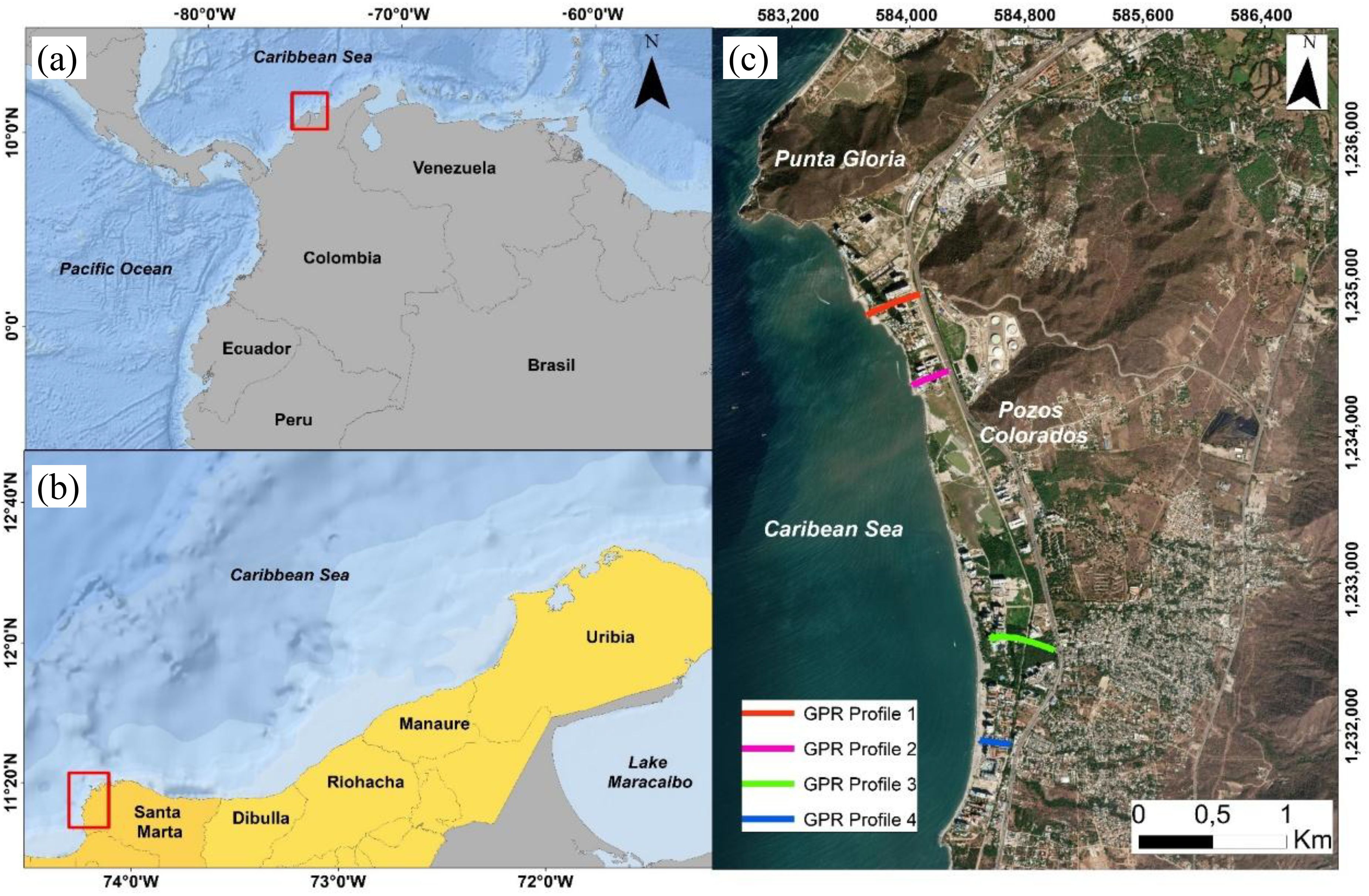
Figure 1. (a, b) Location map of the study area in the Pozos Colorados sector, Santa Marta, Colombia. (a, b) Regional and departmental context. (c) Detailed view of the coastal barrier system with GPR profiles (Profiles 1–4). Background: Esri World Imagery (multisource mosaic); typical resolution 0.3–1 m in urban areas and ~1 m elsewhere; 15 m at small/mid scales. CRS: WGS 84/UTM Zone 18N. Imagery credits: Esri, Maxar, Earthstar Geographics, CNES/Airbus DS, USDA, USGS, AeroGRID, IGN, and the GIS User Community (Esri, 2023).
Within this context, recent urban expansion and human activities have overlapped a coastal strip of the Colombian Caribbean shoreline whose current configuration reflects the interaction among eustatic, tectonic, and sedimentary processes.
At a regional scale, the Holocene evolution of this continental margin has been governed by sea-level fluctuations and vertical dynamics associated with tectonic activity and differential subsidence. Paleo–sea-level indicators corresponding to the mid-Holocene are situated 2–3 m above the present mean sea level, suggesting that the Caribbean coastline, including the Santa Marta and Pozos Colorados sectors, has not remained isostatically stable (Robert and Martínez, 1999). Tide-gauge records and palaeoceanographic reconstructions for the Caribbean Basin indicate an average sea-level rise of approximately 20 cm between 1880 and 1980, with rates ranging from 1.0 to 2.0 mm yr−1 and a regional mean of 1.7 ± 1.3 mm yr−1 (Gornitz et al., 1982; Houghton et al., 1994; Torres et al., 2008; Torres et al., 2017). This spatial variability is linked to atmospheric forcing (e.g., wind stress), oceanic mass redistribution, and differential vertical crustal movements.
At a local scale, the Pozos Colorados sector lies within a morphotectonic transition zone where the structural influence of the Sierra Nevada de Santa Marta (SNSM) converges with the marine dynamics of the Colombian Caribbean coast. The geological evolution of the SNSM, controlled by major fault systems such as the Oca Fault and the Santa Marta–Bucaramanga Fault System, has shaped an environmentally sensitive and highly dynamic coastal landscape (Tschanz, 1969; Doolan, 1970; Hermelin, 2016; Vargas-T. et al., 2016). More recent geodynamic studies indicate that this margin is affected by active interplate coupling and differential vertical deformation associated with these same fault systems (Lizarazo et al., 2021). These structural conditions, combined with eustatic sea-level variability, modulate the relative stability of the area and control its present geomorphological configuration.
The Pozos Colorados coastal plain, of Quaternary age, has developed under the combined influence of fluvial discharge from the SNSM, wave action, and longshore currents driven by trade winds, which govern sediment transport and shoreline evolution along this sector of the Colombian Caribbean (Torres and Andrade, 2006; Marriaga, 2009; Manzolli et al., 2024). This coastal sector is characterized by a mixed semidiurnal microtidal regime, with average tidal amplitudes ranging from 0.3 to 0.5 m (García et al., 2011). This limited tidal range restricts the vertical zonation of coastal environments and increases their sensitivity to sea-level variations and high-energy events, such as storms and swell waves.
Overall, the interaction among inherited tectonic controls, marine–sedimentary processes, and contemporary anthropogenic pressures has produced a dynamic and environmentally fragile coastal landscape.
2 Data and methods
2.1 Geomorphological map
Satellite images (Table 1) were analyzed to identify geomorphological features, variations in terrain texture, and shoreline modifications. Band composition was performed in ArcGIS 10.8 by integrating the red, green, and blue channels to enhance the visualization of key landscape elements (Napieralski et al., 2013; Polizel and Rossetti, 2014), (Table 2) Historical aerial photographs (Table 3) were also incorporated and georeferenced to Google Earth Pro imagery using ground control points referenced to the Magna-SIRGAS datum, with the Gauss-Krüger West Origin projection and the WGS84 ellipsoid. Processing was carried out in ArcGIS 10.8 through a first-order polynomial transformation, and planimetric accuracy was adjusted according to image quality by applying a variable number of control points placed at clearly identifiable features.

Table 1. Satellite imagery used for geomorphological mapping and shoreline analysis (Pozos Colorados).

Table 2. Interpretation criteria for dated geomorphological environments.

Table 3. List of satellite images used in geomorphological mapping.
Georeferencing errors were assessed by visually comparing the adjusted photographs with the base map, while spectral signature analysis was subsequently performed in ArcGIS 10.8 to enhance reflectance differences and improve the discrimination of geomorphological features. To contextualize the coastal setting prior to major anthropogenic interventions, historical cartography, scientific literature (Table 4), and previous studies were also reviewed. Finally, we used the methodology proposed by Berrocoso et al. (2007), Carvajal (2012), and Torrecillas et al. (2024).

Table 4. Ancient cartography and historical maps consulted.
2.2 Coastal dynamic analysis (Coastsat)
The open-source package CoastSat (developed in Python and available at GitHub: https://github.com/kvos/CoastSat) was used to extract shoreline time series from satellite imagery processed through the Google Earth Engine platform (Vos et al., 2019). A total of 1316 images were initially retrieved from the missions Landsat 5 (129), Landsat 7 (401), Landsat 8 (232), Landsat 9 (51), and Sentinel-2 (503), covering the period 1986–2024. After applying strict filters for cloud cover, resolution, and geometric accuracy, only 576 quality-controlled images were retained for analysis.
A set of 32 shoreline transects was generated in QGIS, each 350 m in length and spaced 200 m apart, following the methodology of Vos et al (Vos et al., 2019). Shoreline change rates were calculated exclusively with the End Point Rate (EPR) method, which measures the net displacement between the earliest and most recent shoreline positions divided by the time interval. EPR was preferred over other common metrics such as LRR (Linear Regression Rate), NMS (Net Shoreline Movement), or SCE (Shoreline Change Envelope), since the main objective was to determine net rates of erosion and accretion over a multi-decadal timescale. Unlike LRR, which depends on multiple intermediate positions and may be affected by data gaps, or NMS and SCE, which only capture maximum displacements without temporal scaling, EPR provides a direct, robust, and comparable indicator of shoreline dynamics. Statistical calculations were performed in Minitab 17, ensuring consistency in the estimation of erosion and accretion rates.
2.3 Stratigraphic profiling using ground penetrating radar
Stratigraphic data were collected using a Yuma2 Trimble® data collector coupled with a Cobra Plug-In GPR system (Radarteam Sweden AB) equipped with an 80 MHz monostatic airborne antenna (Subecho SE-70, Radarteam Sweden AB). The system operates with a 120 MHz bandwidth and provides a penetration depth of up to 30 meters. Data acquisition followed the methodology proposed by Barboza et al. (Barboza et al., 2014a), applying high-pass filters, stacking, and gain adjustments during the survey. Positioning was determined using a Trimble® ProXRT GNSS receiver (WGS84). Topographic data were integrated with the GPR profiles to obtain the actual subsurface depth.
The radar waves reached a penetration depth of 30 meters (100 ns). Data processing was performed using Reflex-Win®, Radan™, and Prism2® software packages, including trace analysis (Leandro et al., 2019), background removal, band-pass frequency filtering (ORMSBY filter), gain equalization, and time-to-depth conversion. A dielectric constant of 10, corresponding to wet sand, was used for the velocity conversion, representing 0.09 m/ns (Daniels et al., 1995). Stratigraphic interpretation followed a seismostratigraphic approach adapted for GPR data (Neal, 2004), based on reflection terminations (onlap, toplap, downlap, and truncation) and reflection geometry (Mitchum et al., 1977; Barboza et al., 2014b).
The four GPR profiles were acquired in May 2019, during the transitional season under stable weather conditions (28°C, clear skies, 85% relative humidity). Surveys were conducted along crest and swale topography in a WSW–ENE (sea-to-land) direction, following streets without obstacles or elements that could significantly interfere with the antenna signal (see locations in Figure 1c).
2.4 Identification of potential paleoshorelines
Paleoshoreline identification was performed using remote sensing data through a high-resolution Digital Elevation Model (DEM) derived from LiDAR (Light Detection and Ranging) technology, with a spatial resolution of up to 30 cm. Data processing was carried out in ArcGIS 10.8, applying a GIS-based paleoshoreline extraction tool developed by Schneider (2019), Oviedo-Prada et al. (2021), Osorio-Granada et al. (2022). This method combines slope and curvature analysis of the DEM to detect shoreline features in inaccessible areas and zones without preserved paleocoastal sediments (Hoffmann et al., 2020; Cruz-Ramirez, 2024).
The DEM input serves as the basis for derivative calculations, while Stream_30m, which represents watercourses in vector format, is converted to raster format for integration into the analysis. The main processing steps are as follows:
● Slope Analysis: Derived from the DEM and reclassified into relevant intervals to evaluate terrain inclination.
● Aspect Analysis: Identifies slope orientation, categorizing areas with directions favorable for paleoshoreline detection.
● Curvature Analysis: Calculates total curvature, distinguishing between profile curvature (vertical slope changes) and plan curvature (horizontal surface changes). Both metrics are reclassified to highlight significant morphological patterns.
● Stream Processing: Converts vector stream data into raster format and reclassifies it for integration into the model.
● Model Integration: All reclassified layers (Reclass_Slope, Reclass_Aspect, Reclass_Curvature, Stream_Reclass) are combined using the Raster Calculator, with weighted influence for each factor to enhance paleoshoreline detection.
● The final model outputs a precise delineation of areas with the highest probability of representing former shoreline positions, supporting geomorphological analysis and coastal evolution reconstruction.
2.4.1 Field validation of paleoshorelines
Remote sensing interpretations of paleoshorelines were systematically compared with in situ observations collected during field campaigns. Verification sites were selected based on accessibility and representativeness of key geomorphological features. At each site, GPS-referenced photographs were taken, and sedimentological descriptions were recorded, with a focus on terrace morphology, textural contrasts, and stratigraphic relationships. These field observations were then integrated into the GIS database to corroborate and refine the mapped shoreline positions.
2.5 Paleo sea level modeling
As part of the analysis, paleo–sea-level modeling was performed to reconstruct eustatic highstand events from the Late Quaternary. The methodology was implemented in Python, using a Digital Elevation Model (DEM) in ESRI GRID (.adf) format processed with the Rasterio library. Elevation values, spatial reference, and spatial extent were extracted, and NoData cells were replaced with NaN to prevent computational errors. A georeferenced coordinate mesh (X, Y) was generated from the DEM’s affine transformation to ensure spatial consistency. Two key highstand scenarios were selected:
● MIS 5e (~125 ka, +6 m): Corresponding to the Last Interglacial (Eemian), characterized by slightly warmer-than-present global temperatures and sea levels ~6 m higher than today (Polyak et al., 2018). This scenario represents conditions of advanced polar ice-sheet retreat under a warm climate.
● Flandrian Transgression (~6 ka, +3 m): Associated with the mid-Holocene sea-level maximum (Zazo, 2006), coinciding with the Holocene Climate Optimum, a period of higher temperatures and relative sea-level stability. Its relevance lies in the archaeological timescale, providing recent evidence of shoreline adjustments.
For each scenario, inundation modeling was carried out by applying a flood threshold: all cells with elevations ≤ the simulated sea level were classified as inundated (NaN), while cells above that elevation were retained as emerged terrain.
The outputs generated in Python were exported as TIFF files and subsequently processed in ArcGIS 10.8. To enhance visual interpretation, a Hillshade layer derived from the DEM was integrated to improve the perception of geomorphological units. Urban and road infrastructure data were incorporated from the OpenStreetMap database using vector layers of polygons and lines (roads, buildings, and built-up areas), which were filtered and symbolized to reflect their spatial distribution within high-risk zones.
Finally, all layers were integrated and processed within a GIS environment (ArcGIS 10.8), ensuring a coherent, high-accuracy, and scientifically robust cartographic representation, suitable for spatial comparison between paleoclimatic conditions and the modern coastal configuration.
2.5.1 Hypsometric modeling of paleoshorelines
The map of hypsometric shoreline lines corresponding to the Flandrian (+3 m) and Marine Isotope Stage 5e (MIS 5e, +6 m) scenarios was generated using a Digital Elevation Model (DEM) as a conceptual reference. Automated procedures in Python were applied to extract hypsometric contours that delineate the relative shoreline positions under the defined sea-level increments. The resulting lines were exported in Shapefile (SHP) format and subsequently processed in ArcGIS 10.8, where a spatial comparison was performed against the present-day coastline.
2.6 Integration of methods
We integrated three lines of evidence within a reproducible spatial workflow to link inherited geological structure, recent coastal dynamics, and future exposure. The characterization of the main geomorphological features defined the geological context and composition of the study area. Ground Penetrating Radar (GPR) data delineated basement highs, erosional surfaces, terraces, and depressions, allowing to identify both geological controls and vulnerable surfaces. These results were compared with the identification of paleoshorelines detected using the model created by Schneider (2019).
The shoreline series from 1986 to 2024 (derived from CoastSat) were used to calculate the End Point Rate (EPR) along evenly spaced transects, allowing the characterization of spatial and temporal shoreline patterns, i.e., retreat and accretion trends, which allowed to complement and validate the GPR interpretations. Finally, the paleo– and future–sea-level rise (SLR) analysis projected three scenarios-MIS 5e (+6 m), Flandrian (+3 m), and 2100 under SSP5-8.5 (+1 m) onto a high-resolution Digital Elevation Model (DEM) corrected for hydraulic connectivity, in order to estimate the potential reoccupation of previously mapped low-lying geomorphological surfaces.
All datasets were standardized to the same DEM resolution. From this harmonized framework, we derived hypsometric and slope metrics to conceptually contextualize the low-relief morphology expressed under different projected sea-level rise scenarios.
3 Results
3.1 Regional geomorphology
In the Pozos Colorados sector, a diverse suite of landforms reflects multiple Quaternary depositional settings. Through geomorphological mapping, twelve classes were delineated, which are synthesized in Figures 2a, b. Some landforms have persisted and remain visible, such as beach deposits, fluvio-marine plains, alluvial fans, low surfaces, hillsides, abrasion platforms, high and low hills, coastal floodplains, and lagoons. While others, including marine terraces and paleo-drainage systems, have been obliterated or obscured by extensive anthropogenic transformation.

Figure 2. (a) PSScene satellite image (RGB 541 combination), and (b) Geomorphological map generated from the integration of historical aerial photographs, satellite imagery, cartographic data, and secondary information sources.
3.1.1 Beach deposits
Beach deposits extend for ~4 km from Punta Gloria (north) to the abrasion platforms near Simón Bolívar Airport (south). These Quaternary sands are light-gray, silty, and fine- to coarse-grained (MD = 0.13–0.63 mm), with moderate to poor sorting indicative of mixed sediment sources and moderate-energy conditions shaped by overwash redistribution. Littoral bars and spits contribute to the formation of sandy ridges, while the construction of groynes has partially reduced erosion but also altered the natural shoreline configuration.
3.1.2 Fluvio-marine plains
Located immediately landward of the present beach, these plains are most developed near Punta Gloria and south of the airport, covering an area of 922,864 m². They consist of organic-rich, transitional deposits formed under the influence of marine conditions and runoff from nearby relief. Their flat, low-lying topography has been shaped by pluvial drainage, which transports colluvial material downslope, with interbedded bioclastic layers producing a heterogeneous substrate. Seasonal flooding sustains wetlands and mangrove stands, which play a critical role in the functioning of the coastal ecosystem.
3.1.3 Alluvial fans
Prominent in the southwestern sector, alluvial fans prograde from the mountain foothills onto the lower plains and span 6,051,871 m². Drainage is low-density and sub-parallel, typical of intermittent flows. Coarse sands with lamination in main lobes indicate high-energy pulses, while finer, cross-laminated sediments along the margins reflect lower-energy deposition. Colluvial input from nearby slopes highlights the cyclical formation of fans. These fans buffer sediment and water flows into adjacent plains; however, intense human occupation has disrupted drainage and reduced recharge capacity, altering the sedimentary and hydrological balance.
3.1.4 Low surfaces and hillsides
These gently sloping landforms occupy the northeastern sector between low hills. Low surfaces cover 279,506 m², while adjacent hillsides extend over ~309,405 m². Detrital infill, coupled with runoff from nearby promontories, promotes episodic accumulation linked to gravity-driven processes and rainfall-induced transport, which contributes to the coastal sediment budget.
3.1.5 Abrasion platforms
Wave-cut platforms developed on crystalline rocks of the Santa Marta Batholith cover ~111,659 m² and are locally mantled by light-gray, fine- to coarse-grained sands. Near the airport, they are more exposed due to the combined effects of wave and wind action. These gently seaward-dipping surfaces are important indicators of paleo-sea levels and long-term tectono-marine interactions.
3.1.6 High and low hills
Composed of biotite–hornblende igneous rocks from the Santa Marta Batholith and Rodadero Formation, these Paleogene units (48.8 ± 1.7 to 44.1 ± 1.6 Ma) rise 50–125 m. High hills exhibit rounded crests and convex slopes of 10–20°, while low hills present slopes of 5–10° (Tschanz, 1969; Marriaga, 2009; Idárraga et al., 2011; Sanchez and Kammer, 2015). The high hills in the east cover 12,124,621 m², and the low hills in the north occupy 2,981,138 m². These reliefs exert strong control over drainage patterns and sediment routing in the region.
3.1.7 Coastal floodplains
The coastal floodplains are flat, low-lying zones that stretch along the shoreline, playing a key role in shaping the local coastal landscape. These areas formed under the influence of denudational, tectonic, fluvial, and marine processes. They are bordered by alluvial fans to the south and interlaced with gently sloping low hills of the Rodadero Formation (Sanchez and Kammer, 2015).
The nearly flat topography suggests that, in the past, these plains facilitated the accumulation of fine sediments transported by rivers, wave action, and coastal currents. The material composition also reflects a complex mixture of fluvial sands and silts, colluvial inputs from nearby slopes, littoral and tidal sands, and biogenic marine-derived material such as shell fragments and organic matter. These floodplains likely expand during marine regressions and contract during transgressions. The total area covered by these floodplains is approximately 5,564,467 m².
3.1.8 Coastal lagoons
Formed by spits and littoral bars extending from Punta Gloria and shaped by longshore drift, these lagoons are semi-enclosed behind sandy ridges, creating favorable conditions for mangrove and estuarine vegetation. Distributed across the fluvio-marine plain, they cover 64,125 m². Fine muds and clays with organic matter dominate the basins, while sandy deposits fringe the margins. Anthropogenic intervention has altered natural connectivity, promoting eutrophication and mangrove decline.
3.1.9 Marine terraces
Although now buried beneath colluvial deposits, marine terraces previously mapped near the low hills occur at shallow depths. Their moderate slopes and drainage patterns indicate a geomorphological evolution influenced by tectonic uplift during the Cenozoic particularly the late Miocene and Pleistocene and by sea-level oscillations associated with glacial–interglacial cycles. Thesexterraces cover an estimated total area of approximately 800,071 m².
3.1.10 Paleo-drainage channels
The paleo-drainage systems are linked to the region’s geomorphological and tectonic evolution. Past fluvial erosion and sediment transport shaped these channels, which were later abandoned due to tectonic uplift and fluvial reconfiguration. Colluvium and fan deposits subsequently infilled these features. In modern times, anthropogenic activities, such as urbanization and the construction of drainage canals, have fragmented these ancient channels and diminished their hydrological function.
3.2 Shoreline changes (1986–2024)
Shoreline analysis in Pozos Colorados using CoastSat (1986–2024) revealed a predominantly erosional trend, strongly linked to anthropogenic pressures and the transformation of natural coastal features. In the earliest records from 1986, the coastal configuration was dominated by littoral bars, coastal lagoons, mangroves, and alluvial deposits derived from the Santa Marta Batholith. However, subsequent years documented significant alterations, including the partial infilling of lagoonal systems and modifications to alluvial deposits. A critical phase of intervention began in 1991, when groynes construction disrupted longshore drift, promoting updrift accretion and downdrift erosion, while lagoon canalization reduced hydrological connectivity. By 2003, littoral bars had been entirely reconfigured, producing a zigzag shoreline morphology indicative of artificial stabilization.
Consistent with these transformations, shoreline change rates derived from the End Point Rate (EPR) method (Figure 3) confirmed the predominance of erosion, with maximum retreat recorded between 1986 and 2005 and intermittent accretion in some sectors after 2005. Overall, the shoreline exhibited a sustained landward migration, with only partial stabilization observed in recent years.

Figure 3. (a) Spatial distribution of shoreline change rates (End Point Rate, EPR) along the Pozos Colorados sector from 1986 to 2024. (b) Time series of shoreline position illustrating interannual variability and long-term trends based on the moving average of EPR values.
Results demonstrate that the moving average EPR reinforces this erosional trend, with localized recovery reaching +4.39 m yr−1 in 2021, in contrast to a maximum retreat of –15.04 m yr−1 in 1996 and an overall mean of –2.00 m yr−1, confirming erosion as the prevailing coastal process. The multi-decadal trend and moving average are shown in Figure 4. Five-year interval analysis further highlights alternating phases of accretion and erosion: 1986–1990 with prevailing accretion, followed by strong erosion in 1990–1995 (> –5 m yr−1), recovery in 1995–2005 with peaks > +10 m yr−1 across several transects, intensified erosion in 2010–2015, and a critical retreat in 2015–2020 (> –10 m yr−1). Between 2021 and 2024, a partial recovery was recorded, with reduced erosion and localized accretion. Nevertheless, persistent negative trends across multiple transects reveal sustained coastal instability, primarily driven by fluctuations in the sediment budget, extreme climatic events, and cumulative anthropogenic pressures.

Figure 4. Shoreline change trends by transecting over five-year intervals from 1986 to 2024.
3.3 Sequence stratigraphy
Ground-penetrating radar (GPR) surveys generated four subsurface profiles across the coastal barrier system of Pozos Colorados (see location in Figure 4). Interpretation of radar reflections allowed the identification of three main depositional units: (I) bedrock substrate, (II) Pleistocene alluvial fan deposits, and (III) Holocene aeolian deposits (Figures 5A–D). Unit I is marked by medium-amplitude, continuous reflections with hyperbolic diffractions and signal attenuation, typical of basement rocks. Overlying this surface, Unit II displays high-amplitude but discontinuous reflections with hummocky patterns and onlap/downlap terminations, indicating infill of depressions carved into the bedrock. Unit III consists of high-amplitude, subparallel reflections with low-angle landward downlaps, diagnostic of transgressive Holocene sand sheets (Hesp et al., 2005; Watanabe et al., 2025).

Figure 5. Subsurface ground-penetrating radar (GPR) profiles from the Pozos Colorados sector. Three depositional units were identified: Unit I (rocky substrate or basement), Unit II (Pleistocene alluvial fan deposits), and Unit III (Holocene aeolian sands). Profile (a) shows an uplifted basement high; profile (b) a stabilization terrace within the alluvial sequence; profile (c) a seaward-inclined surface with angular unconformities; and profile (d) an undulating basement with depressions filled by alluvial and aeolian deposits. Altogether, the profiles reveal the morphostructural control of basement variability on the stratigraphic architecture of the coastal barrier system.
Profile (a) exhibits a clear basement uplift within the first 90 meters, from southwest to northeast, revealing a positive paleotopography likely formed by tectonic or erosional processes predating sediment deposition. This substrate irregularity acted as a structural barrier, controlling the thickness and geometry of the overlying sediments. The onlap geometry of the reflectors over the elevated relief confirms the presence of an initially irregular surface that influenced the accumulation of Pleistocene and Holocene units, reflecting a depositional history governed by both inherited topography and coastal environmental fluctuations.
Within the geomorphological context of Pozos Colorados, this structure corresponds to the transition zone between the fluvio-marine plain and the coastal plain. Over this relief, the upper units consist of Holocene marine and eolian sands, associated with sustained vertical aggradation rather than lateral progradation. The onlapping arrangement and the superposition of marine units over continental deposits indicate the influence of an early Holocene transgressive phase, followed by a stage of sea-level stabilization and progressive vertical aggradation. This evolution suggests that, after stabilization, the system shifted toward vertical accumulation under low-energy conditions, forming an apparently stable yet geomorphologically fragile coastal surface, which remains susceptible to gradual and persistent erosion as a response to reduced sediment supply and increasing wave energy.
Profile (b) reveals the existence of Unit I gently dipping Unit I toward the northeast, interpreted as the bedrock or paleosubstrate upon which subsequent sedimentation developed. This upward trend indicates a pre-existing inclined paleorelief that influenced later depositional processes. Between 100 and 180 meters, a subhorizontal terrace-like surface interrupts the general slope, and it was interpreted as a temporary stabilization phase within the alluvial system, likely caused by a decrease in flow energy or a pause in sediment supply. This surface acted as a local base level, controlling the accumulation of fine sediments in the overlying units. The presence of this flat surface may also suggest a distal marine influence, related to a relative sea-level rise during an early transgressive phase, which temporarily modified the sedimentary equilibrium of the system.
Above this terrace, Units II and III display discordant stratigraphy, with onlap, downlap, and truncation terminations, indicating episodic and pulsating sedimentation. Nevertheless, the tabular geometry and lateral continuity of the reflectors suggest a progressive aggradational trend, derived from vertical deposition under lower-energy conditions. Unit II represents a stabilized fluvio-marine infill phase, while Unit III, thinner and more homogeneous, corresponds to a recent Holocene stage, associated with eolian or shallow-marine environments, marking the final consolidation of the present surface.
Profile (c), oriented northwest–southeast and located near the outlets of the alluvial fans, presents a morphostructural configuration controlled by bedrock topography (Unit I). This unit shows an upward inclination toward the northwest, near the coastal front, and a downward slope toward the southeast, inland, suggesting a combined influence of paleogeographic erosional processes and differential tectonic uplift. The shape of the basement likely acted as an elevated paleosurface, regulating the accumulation of alluvial and coastal sediments during subsequent stages.
Resting discordantly on this irregular surface, Unit II exhibits a lenticular infill geometry, adapting to the depressions of the substrate. This unit reflects an alluvial accumulation phase, controlled by paleotopography and periods of enhanced fluvial activity or greater water availability, typical of the transitional zone between the alluvial fans and the coastal plain. The onlap and downlap terminations reinforce the interpretation of a vertical and progressive aggradation of the accommodation space, rather than a lateral progradational advance. Unit III, more continuous and subhorizontal, represents recent Holocene eolian deposits, accumulated under arid and stable conditions, which seal the system and mark the closure of active sedimentary dynamics.
Profile (d) shows an undulating basement morphology, with central and southeastern depressions that provided accommodation space for coarse alluvial fills, also displaying a dominant aggradational behavior. Unit II exhibits conformable configurations, consistent with fluvial inputs from the southern drainage system of Pozos Colorados, later overlain by Holocene eolian deposits that seal the system and represent the final stage of surface aggradation and stabilization, preceding the onset of the current phase of intermittent coastal erosion.
Overall, the Holocene coastal transgression likely affected the Pozos Colorados system in a differential manner—being more pronounced in the coastal sectors of Profile (a), attenuated in the intermediate zone of Profile (b), and practically absent in Profiles (c) and (d). This pattern is consistent with a marine transgression followed by a vertical aggradational phase during sea-level stabilization, with the modern coastline representing a post-transgressive stage, where the system continues to adjust to the imbalance between sediment supply and marine energy.
3.4 Paleoshorelines
Remote sensing analysis allowed the detection and preliminary mapping of paleoshorelines in the Pozos Colorados sector. These features were subsequently validated through field surveys (see Table 5), which confirmed diagnostic landforms including marine terraces, fossil beach ridges, and relict alluvial fans. The integration of remote sensing within situ verification ensured the reliability of the mapped paleoshoreline positions (Figure 6).

Table 5. Field verification points and geomorphological interpretations.

Figure 6. Geomorphological mapping and field verification in the Pozos Colorados coastal barrier. Polygons represent the Quaternary coastal plain (yellow), Pleistocene Marine Terraces (blue), and Alluvial fans (purple). Red stars mark field verification sites: (1) densely vegetated hill with rocky outcrops, interpreted as a modified marine terrace margin; (2) irregular relief with sandy to silty soils and poor drainage, likely an eroded fossil bar; (3) inclined rocky outcrop with fractures and differential erosion, corresponding to a former marine cliff; (4) steep slope with mixed marine–continental sediments, indicative of a transitional coastal plain; and (5) moderate slope with stable soils and dense vegetation, associated with paleoshorelines influenced by alluvial fan activity.
The geomorphological map distinguishes three shoreline units. The youngest corresponds to late Quaternary coastal plain (yellow), directly associated with modern coastal landforms. An intermediate unit is represented by marine terraces and fossil beach ridges (blue), which record former higher sea-level stands. The oldest unit (purple) is linked to alluvial fan activity and preserves relict deposits at higher elevations. Field validation sites, indicated by red stars, confirmed the presence of these landforms through terrace preservation, variations in sedimentary facies, and textural contrasts. Georeferenced photographs (sites 1–5) further document the diversity of coastal morphologies and provide a stratigraphic context for interpreting shoreline evolution.
3.5 Paleo sea-levels
Paleo-sea-level modeling in the Pozos Colorados sector was carried out under three scenarios: Marine Isotope Stage 5e (MIS 5e, +6 m; ~125 ka) (Muhs et al., 2003; Dutton and Lambeck, 2012), the Flandrian Transgression (+3 m; ~6 ka) (Pirazzoli and Pluet, 1991; Toscano and Macintyre, 2003), and a projected future high-emissions scenario for 2100 (+1 m; SSP5-8.5) (Masson-Delmotte et al., 2021). Together, these reconstructions provide insights into past interglacial shoreline configurations and anticipated impacts of future sea-level rise (Figures 7, 8).

Figure 7. Paleo sea-level scenarios modeled for the Pozos Colorados sector. (A) MIS 5e (+6 m, ~125 ka), showing extensive inundation of coastal barriers and alluvial deposits, reaching up to 1 km inland. (B) Flandrian Transgression (+3 m, ~6 ka), indicating moderate flooding confined to low-elevation coastal depressions and lagoonal areas. (C) Projection for 2100 under a high-emissions pathway (+1 m, SSP5-8.5), highlighting risks to urban, commercial, and touristic infrastructure, as well as potential saltwater intrusion into aquifers.

Figure 8. Hypsometric map of the Pozos Colorados coastal plain showing present shoreline (red), Flandrian shoreline (+3 m, blue), and MIS 5e shoreline (+6 m, black). Transgression limits coincide with morphostratigraphic surfaces such as marine terraces, relict alluvial fans, and lagoonal depressions, confirming their role as persistent loci of accommodation space and vulnerability across Quaternary to Anthropocene sea-level highstands.
The MIS 5e scenario (+6 m) indicates a major marine incursion, with inundation reaching up to 1 km inland from the modern shoreline. Submerged areas primarily include Quaternary coastal barriers and unconsolidated alluvial deposits, underscoring their high susceptibility to transgression. This extent is consistent with global warming conditions and glacioeustatic responses associated with partial polar ice-sheet collapse during the last interglacial.
The Flandrian Transgression (+3 m; ~6 ka) depicts a more moderate marine advance, concentrated in low-elevation coastal depressions adjacent to the present shoreline. While less extensive than MIS 5e, it nevertheless exerted a strong influence on Holocene barrier reorganization, particularly through reactivation of lagoonal systems and back-barrier connectivity.
The 2100 SSP5-8.5 scenario (+1 m) highlights critical future risks, particularly for urbanized and touristic sectors of Pozos Colorados. Progressive flooding is expected to impact residential, commercial, and tourism infrastructure, posing a threat to real estate developments that have expanded rapidly in recent decades. Additionally, saltwater intrusion into aquifers may compromise freshwater availability in Santa Marta, exacerbating existing water stress. Accelerated coastal erosion is projected to intensify beach loss, undermining tourism investments, the main economic driver of the region. Transportation corridors, including coastal roads, are also at risk of recurrent flooding and soil destabilization.
Integration of inundation models with the hypsometric map (Figure 8) demonstrates that the limits of past and future marine transgressions coincide with present-day low-lying morphostratigraphic surfaces east of the current shoreline. These surfaces include marine terraces, relict alluvial fans, and lagoonal depressions previously mapped as paleoshorelines. This correspondence underscores that the same geomorphic units that registered Quaternary highstands remain the most vulnerable to projected sea-level rise, highlighting the persistence of Morphodynamics controls across glacial–interglacial cycles.
4 Discussion
The results of this study reveal the dynamic interaction between natural processes and anthropogenic pressures that have shaped the Pozos Colorados coastal barrier over millennial to decadal timescales, with a marked acceleration of human influence in recent decades. The integration of remote sensing, multi-temporal shoreline analysis, geophysical subsurface imaging (GPR), and paleo-sea-level modeling allowed for a comprehensive reconstruction of the geomorphological evolution of this sector of the Colombian Caribbean, linking past coastal dynamics to present instability and future risk.
The identification of twelve morphogenetic units underscores the heterogeneity of depositional environments and hydrosedimentary regimes. Features such as beach deposits, alluvial fans, abrasion platforms, marine terraces, and coastal lagoons reflect a long history of eustatically driven transgressions and regressions during the Pleistocene and Holocene. This stepped configuration is consistent with regional and global studies (Pirazzoli and Pluet, 1991; Lambeck et al., 2002; Muhs et al., 2003; Toscano and Macintyre, 2003), which emphasizes the role of Quaternary sea-level oscillations in the construction of coastal landscapes.
Multitemporal shoreline analysis carried out by means of the CoastSat tool revealed a predominantly erosional pattern between 1986 and 2024, characterized by marked temporal fluctuations. The 1980s and 1990s the shoreline experienced a pronounced retreat, followed by alternating phases of localized accretion and erosion, including an intense retreat between 2015 and 2020 and a partial recovery after 2020. Despite limitations associated with image resolution, this pattern aligns with reported coastal instability in other Caribbean settings (Villate et al., 2020; Manzolli et al., 2024) and comparable barrier systems worldwide (Schuerch et al., 2018), attributed to the combined effects of increasing wave energy (Adams et al., 2024), declining fluvial sediment supply (Neal et al., 2002) and intensifying urban development. This ongoing erosional regime has led to the degradation of beaches, wetlands, mangroves, and seagrass meadows, directly affecting ecosystem services such as storm buffering and nutrient cycling (Simms et al., 2011; Anderson et al., 2014) as well as artisanal fisheries and local livelihoods (Villate et al., 2020; Manzolli et al., 2024).
Paleoshoreline mapping and paleo-sea-level reconstructions reinforce this long-term vulnerability. The simulated inundation envelopes for MIS 5e (+6 m) and the Flandrian Transgression (+3 m) show strong spatial overlap with fossil terraces, beach ridges, and relict lagoonal systems observed in the field. This congruence validates the reliability of digital elevation models for paleogeographic reconstructions (Kopp et al., 2009; Griggs and Reguero, 2021) and highlights the fundamental role of past transgressions in shaping the stepped topography of Pozos Colorados. Importantly, these inherited low-lying surfaces coincide with the zones projected to be re-inundated under future sea-level rise.
The SSP5-8.5 scenario for 2100 (+1 m) highlights the persistence of long-term geomorphological controls on coastal vulnerability. Similar to conditions during MIS 5e and the mid-Holocene, areas underlain by Quaternary barrier deposits and unconsolidated alluvial fans are projected to remain the most exposed. This continuity reflects how inherited topography and sedimentary composition condition the spatial distribution of future inundation areas, emphasizing that past coastal evolution allows to predict present and future risk patterns, particularly in zones now occupied by urban and tourism infrastructure. Projected impacts include chronic flooding, accelerated shoreline retreat, saltwater intrusion, and groundwater rise processes already documented as critical hazards for coastal aquifers and infrastructure (Simms et al., 2011; Thinh et al., 2019; Bosserelle et al., 2022; Spencer et al., 2022). The implications extend beyond physical vulnerability to socio-economic systems: real estate expansion, tourism competitiveness, and water security in Santa Marta are likely to face increasing stress, paralleling trends observed in other densely urbanized tropical coasts (Ministry of Water Resources, 2004; Jacinto et al., 2006; Rangel-Buitrago et al., 2015; Saengsupavanich et al., 2023).
Subsurface geophysical analysis complements these findings by documenting the internal stratigraphy of the barrier system. GPR profiles reveal three key depositional units: fractured bedrock, Pleistocene alluvial infill, and Holocene aeolian sands. The occurrence of paleo-topographic highs, erosional unconformities, terraces, and depressions demonstrates that the stratigraphic architecture of Pozos Colorados is controlled by basement morphostructure, which governed accommodation space and sediment pathways. This emphasizes the need to account for inherited geological controls when interpreting modern shoreline change (Tamura, 2012; Anderson et al., 2014; Leandro et al., 2019).
Overall, the evidence indicates that the vulnerability of Pozos Colorados is not only a function of present-day human pressures but also of its inherited geomorphological framework. The persistence of erosion despite intermittent stabilization reflects the compounded effect of long-term transgressive history, sediment-starved conditions, and anthropogenic alteration. The integration of remote sensing, modeling, and geophysics thus provides a robust basis for anticipating future change and underscores the need for science-based coastal management strategies that explicitly consider geomorphological inheritance.
5 Limitations
Several limitations of this paper must be acknowledged. First, the sea-level rise (SLR) model applied in this study is static in nature, since it does not incorporate dynamic processes such as waves, tides, currents, or storm surges, which may alter the actual extent of future flooding events. Second, the analysis relies on the spatial resolution of available satellite imagery, which constrains the detection of fine-scale shoreline changes. Third, bathymetric data were not included, limiting the capacity to model nearshore hydrodynamics. Finally, groundwater dynamics were inferred from literature and geomorphological evidence but were not directly monitored in the field. These constraints should be addressed in future research to improve the accuracy of coastal risk projections.
6 Conclusions and recommendations
This study demonstrates that the Pozos Colorados coastal barrier is a system whose current instability and future risks are deeply tied to both its inherited geomorphological framework and the anthropogenic pressures that have intensified in recent decades. The integration of tools such as CoastSat, GPR, and paleo-sea-level reconstructions provided robust evidence that the same low-lying surfaces formed during MIS 5e and the mid-Holocene correspond to the most vulnerable areas under 21st-century sea-level rise. The persistence of erosional dynamics, coupled with rapid tourism and real-estate expansion, indicates that the resilience of this shoreline has been significantly reduced, underscoring the urgent need for adaptation strategies.
Beyond surface coastal dynamics, hydrogeological processes emerge as a critical yet underestimated factor: rising groundwater levels and saline intrusion degrade water quality, salinize wells, and negatively affect health and agriculture. Moreover, groundwater rise has been recognized as a driver of chronic flooding and the destabilization of buried infrastructure even in the absence of storms, requiring active management of coastal aquifers. These risks are widely documented globally and in tropical contexts, and have already been addressed in Colombian Caribbean case studies (e.g., the Arroyo Grande coastal aquifer), which provide methodologies for assessing water quality and salinization processes in tropical coastal environments (Han et al., 2015; Arroyo-Figueroa et al., 2024; Zamrsky et al., 2024).
Policy and management lessons from the wider Caribbean highlight a turn toward ecosystem-based adaptation, adaptive spatial planning, and participatory governance. In Cartagena (Plan 4C), the incorporation of climate change adaptation into urban planning instruments and the use of “soft” measures (e.g., mangrove rehabilitation as natural infrastructure) offer a replicable pathway for Colombian coastal cities, albeit with persistent challenges of institutional coordination and implementation (Peter Adams, 2013; Alcaldia de Cartagena et al., 2014). In Cuba, the national program “Tarea Vida” prioritizes beach conservation and recovery, reef and mangrove restoration, and the spatial zoning of adaptation actions in highly vulnerable areas, providing an example of state-led climate policy with a territorial approach (CITMA, 2019). In Barbados, the integration of coastal zone management, regulatory innovation, and a protection accommodation retreat framework has been documented as good practice for sustaining tourism competitiveness in the face of SLR and erosion. Recent assessments of the urban coastal corridor reinforce the need for targeted investments to protect communities and strategic assets. Across the tourism dependent Caribbean, the evidence confirms that beach loss, erosion, and flooding undermine destination competitiveness and place pressure on local economies highly dependent on coastal resources, underscoring the need for sector specific adaptation strategies for tourism (Mycoo, 2014).
6.1 Recommendations for Pozos Colorados and its area of influence include
(I) incorporating SLR scenarios into land use planning instruments (POT/partial plans), delineating buffer zones and planned retreat corridors in low lying surfaces coinciding with paleoshorelines and lagoonal depressions; (II) implementing ecosystem based solutions such as mangrove restoration, dune rehabilitation, and lagoon reconnection to strengthen natural resilience; (III) establishing a long-term monitoring program of shoreline dynamics, sediment budgets, and aquifer conditions (salinity, groundwater levels) to anticipate chronic risks; (IV) developing sectoral adaptation plans for tourism and artisanal fisheries, including the relocation of vulnerable assets, economic diversification, and standards for climate-resilient infrastructure; and (V) fostering participatory governance mechanisms that integrate coastal communities, scientists, and decision-makers, ensuring that adaptation strategies are not only technically robust but also socially inclusive.
In conclusion, the geomorphological legacy of Pozos Colorados demonstrates that exposure to sea-level rise is not merely a future threat but rather the continuation of a long history of marine transgressions. The current challenge lies in transforming this knowledge into concrete adaptation pathways, combining nature-based strategies, policy innovation, and community participation. Only through science-informed and socially grounded governance will it be possible to reduce risk exposure and safeguard the ecological and socio-economic functionality of this coastal system in the face of inevitable sea-level rise.
Data availability statement
The original contributions presented in the study are included in the article/supplementary material, further inquiries can be directed to the corresponding author/s.
Author contributions
DV-D: Resources, Investigation, Visualization, Software, Writing – review & editing, Formal analysis, Writing – original draft, Methodology, Conceptualization. EB-P: Conceptualization, Software, Validation, Methodology, Investigation, Resources, Formal analysis, Writing – review & editing, Writing – original draft. BJ-A: Writing – original draft, Writing – review & editing, Software, Methodology, Validation. JM-P: Validation, Writing – review & editing, Writing – original draft. GA: Conceptualization, Writing – original draft, Writing – review & editing. LP: Writing – review & editing. FA-F: Writing – review & editing, Data curation. RP: Validation, Writing – review & editing, Methodology, Investigation, Writing – original draft, Conceptualization, Resources.
Funding
The author(s) declare that no financial support was received for the research, and/or publication of this article.
Acknowledgments
This research is a contribution to the Graduate Program in Geosciences at the Institute of Geosciences of the Federal University of Rio Grande do Sul (UFRGS), the Andalusian Higher Center for Marine Studies (CASEM), the Institute of Oceanography at the Federal University of Rio Grande (FURG), the Caribbean Center for Oceanographic and Hydrographic Research, and the General Maritime Directorate (DIMAR), and the Andalusia PAI Research Group RNM-373, and RNM-912.
Conflict of interest
The authors declare that the research was conducted in the absence of any commercial or financial relationships that could be construed as a potential conflict of interest.
Generative AI statement
The author(s) declare that Generative AI was used in the creation of this manuscript. The author(s) confirm and take full responsibility for the use of generative AI in the preparation of this manuscript. Generative AI was used solely to improve the quality of the English language during the initial drafting stage. No AI tools were used to generate, analyze, or interpret scientific content, nor to produce results or conclusions.
Any alternative text (alt text) provided alongside figures in this article has been generated by Frontiers with the support of artificial intelligence and reasonable efforts have been made to ensure accuracy, including review by the authors wherever possible. If you identify any issues, please contact us.
Publisher’s note
All claims expressed in this article are solely those of the authors and do not necessarily represent those of their affiliated organizations, or those of the publisher, the editors and the reviewers. Any product that may be evaluated in this article, or claim that may be made by its manufacturer, is not guaranteed or endorsed by the publisher.
References
Adams K. H., Reager J. T., Buzzanga B. A., David C. H., Sawyer A. H., and Hamlington B. D. (2024). Climate-induced saltwater intrusion in 2100: recharge-driven severity, sea level-driven prevalence. Geophys. Res. Lett. 51, 1–9. doi: 10.1029/2024GL110359
Aguilera-Vidal M., Muñoz-Perez J. J., Contreras A., Contreras F., Lopez-Garcia P., and Jigena B. (2022). Increase in the erosion rate due to the impact of climate change on sea level rise: victoria beach, a case study. J. Mar. Sci Eng. 10, 1–14. doi: 10.3390/JMSE10121912
Alcaldía de Cartagena M. A. D. S., INVEMAR C. D. K. N., and de Cartagena C. (2014). Plan 4C Cartagena de Indias Competitiva y Compatible con el Clima Resumen Ejecutivo. (Cartagena, Colombia: INVEMAR (Instituto de Investigaciones Marinas y Costeras)).
Alcaldia de Santa Marta (2020). Acuerdo No 011 “Por el cual se revisa, modifica y expide el plan de ordenamiento territorial “POT 500 años” del Distrito Turístico. Cult. e Histórico Santa Marta 2020-2032, 1–226.
Anderson J. B., Wallace D. J., Simms A. R., Rodriguez A. B., and Milliken K. T. (2014). Variable response of coastal environments of the northwestern Gulf of Mexico to sea-level rise and climate change: Implications for future change. Mar. Geol 352, 348–366. doi: 10.1016/J.MARGEO.2013.12.008
Anfuso G., Rangel-Buitrago N., and Correa Arango I. D. (2015). Evolution of sandspits along the caribbean coast of Colombia. Natural Hum. Influ., 1–19. doi: 10.1007/978-3-319-13716-2_1
Arroyo-Figueroa C., Chalá D. C., Gutiérrez-Ribon G., and Quiñones-Bolaños E. (2024). A framework to evaluate groundwater quality and the relationship between rock weathering and groundwater hydrogeochemistry in the tropical zone: A case study of coastal aquifer arroyo grande, in the caribbean region of Colombia. Water (Switzerland) 16, 1650. doi: 10.3390/W16121650/S1
Barboza E. G., Rosa M. L. C. C., and Caron F. (2014a). Metodologia de Aquisição e Processamento em Dados de Georradar (GPR) nos Depósitos Quaternários da Porção Emersa da Bacia de Pelotas. In: VI Simpósio Brasileiro de Geofísica, Resumos Expandidos. 1, 1–6. doi: 10.13140/2.1.3369.5047
Barboza E. G., Rosa L. C. C., Dillenburg S. R., da Silva A. B., and Tomazelli L. J. (2014b). Stratigraphic analysis applied on the recognition of the interface between marine and fluvial depositional systems. Journal of Coastal Research 70, 687–692. doi: 10.2112/SI70-116.1
Berrocoso M., Paez R., Jigena B., and Caturla C. (2007). The RAP Net: A Geodetic Positioning Network for Andalusia (South Spain). Riga, Latvia: EUREF Publication No. 16, Mitteilungen des Bundesamtes für Kartographie und Geodäsie, Band 40. p. 364–368. Available at: https://acortar.link/8Tteoe (Accessed June 14-17, 2006).
Blum M. D. and Roberts H. H. (2009). Drowning of the Mississippi Delta due to insufficient sediment supply and global sea-levelrise. Nat. Geosci. 2, 488–491. doi: 10.1038/NGEO553;KWRD=EARTH+SCIENCES
Bosserelle A. L., Morgan L. K., and Hughes M. W. (2022). Groundwater rise and associated flooding in coastal settlements due to sea-level rise: A review of processes and methods. Earths. Future 10, 1–26. doi: 10.1029/2021EF002580
Carter R. and Woodroffe C. (1994). Coastal evolution: late quaternary shoreline morphodynamics. (UK: Cambridge University Press). doi: 10.1017/CBO9780511564420
Carvajal H. (2012). Propuesta de estandarización de la cartografía geomorfológica en Colombia (SGC. Bogota-Colombia: Libros del Servicio Geológico Colombiano). doi: 10.32685/9789589952825
CITMA (2019). Tarea Vida An ambitious plan to address climate change (Haban, Cuba: Ministry of Science, Technology and Environment (CITMA)). Available online at: https://www.undp.org/sites/g/files/zskgke326/files/migration/cu/79c4375d278252f07bb0c6398685ebbad412c2e4617b714647e83ec4168971a6.pdf.
Cruz-Ramírez C. J., Chávez V., Silva R., Muñoz-Perez J. J., and Rivera-Arriaga E. (2024). Coastal management: a review of key elements for vulnerability assessment. J. Mar. Sci. Engineering. 12 (3), 386, pp 1–30. doi: 10.3390/jmse12030386
DANE (2018). Proyecciones de Población-Serie Municipal por área, para el periodo 2018-2042. Available online at: https://www.dane.gov.co/index.php/estadisticas-por-tema/demografia-y-poblacion/proyecciones-de-poblacion (Accessed August 17, 2025).
Daniels J. J., Roberts R., and Vendl M. (1995). Ground penetrating radar for the detection of liquid contaminants. J. Appl. Geophy. 33, 195–207. doi: 10.1016/0926-9851(95)90041-1
Doolan B. L. (1970). The structure and metamorphism of the Santa Marta area, Colombia, South America (State University of New York at Binghamton: Binghamton, NY, USA).
Dutton A. and Lambeck K. (2012). Ice volume and sea level during the last interglacial. Science 337, 216–219. doi: 10.1126/SCIENCE.1205749/SUPPL_FILE/DUTTON.SM.PDF
Esri (2023). World imagery (Base map) (Garmin, GEBCO, NOAA NGDC: Service Layer Credits: Source: Esri, Maxar, Earthstar Geographics, and the GIS User Community Esri). Available online at: https://www.arcgis.com/apps/mapviewer/index.html.
Figueroa I., Noriega-Narváez G., and Isabel Márquez-Pérez A. (2025). Estratégias de Privatização dos Espaços Públicos Nas Praias De Santa Marta, Colômbia. - Privatizati. Strat. Of Public Spac. In Beaches Of Santa Marta Colombia. 22, 1–19. doi: 10.18623/rvd.v22.2769-ptbr
FitzGerald D. M., Penland S., and Nummedal D (1984). Control of barrier island shape by inlet sediment bypassing: East Frisian Islands, West Germany. Marine Geology, 60(1–4), 355–376. doi: 10.1016/0025-3227(84)90157-9
García F., Palacio C., and García U. (2011). Tide constituents at santa marta bay (Colombia). Dyna (Medellin) 78, 142–150.
Gornitz V., Lebedeff S., and Hansen J. (1982). Global sea level trend in the past century. Sci (1979) 216, 1611–1614. doi: 10.1126/SCIENCE.215.4540.1611
Griggs G. and Reguero B. G. (2021). Coastal adaptation to climate change and sea-level rise. Water (Basel) 13(16), 2151. doi: 10.3390/W13162151
Hamilton C. A., Kirby J. R., Lane T. P., Plater A. J., and Waller M. P. (2019). Sediment supply and barrier dynamics as driving mechanisms of Holocene coastal change for the southern North Sea basin. Quaternary Int. 500, 147–158. doi: 10.1016/J.QUAINT.2019.02.028
Han D., Post V. E. A., and Song X. (2015). Groundwater salinization processes and reversibility of seawater intrusion in coastal carbonate aquifers. J. Hydrol (Amst) 531, 1067–1080. doi: 10.1016/J.JHYDROL.2015.11.013
Hauer M. E., Fussell E., Mueller V., Burkett M., Call M., Abel K., et al. (2019). Sea-level rise and human migration. Nat. Rev. Earth Environ. 1, 28–39. doi: 10.1038/s43017-019-0002-9
Haxel J. H. and Holman R. A. (2004). The sediment response of a dissipative beach to variations in wave climate. Mar. Geol 206, 73–99. doi: 10.1016/J.MARGEO.2004.02.005
Hermelin M. (2016). Geomorphological landscapes and landforms of Colombia. World Geomorphol. Landscapes 1774, 1–21. doi: 10.1007/978-3-319-11800-0_1
Hesp P. A., Dillenburg S. R., Barboza E. G., Tomazelli L. J., Ayup-Zouain R. N., Esteves L. S., et al. (2005). Beach ridges, foredunes or transgressive dunefields? Definitions and an examination of the Torres to Tramandaí barrier system, Southern Brazil. Acad. Bras. Cienc 77, 493–508. doi: 10.1590/S0001-37652005000300010
Hoffmann G., Schneider B., Mechernich S., Falkenroth M., Dunai T., and Preusser F. (2020). Quaternary uplift along a passive continental margin (Oman, Indian Ocean). Geomorphology 350, 1–13. doi: 10.1016/J.GEOMORPH.2019.106870
Houghton J., Meira Filho L. G., Bruce J., Lee H., Callander B. A., Haites E., et al. (1994). Radiative forcing of climate change and an evaluation of the IPCC IS92 emission scenarios (Switzerland: Geneva).
Idárraga J., Posada B., and Guzmán G. (2011). Geomorfología de la zona costera adyacente al piedemonte occidental de la sierra nevada de Santa Marta entre los sectores de pozos colorados y el río Córdoba, Caribe Colombiano. Boletin Investigaciones Marinas y Costeras 40, 41–58.
Jacinto G., Azanza R., Velasquez I., and Siringan F. (2006). “Manila bay: environmental challenges and opportunities,” in The environment in asia pacific harbours (Springer, Dordrecht), 309–328. doi: 10.1007/1-4020-3655-8_19
Kennedy D. M., Oliver T. S. N., Tamura T., Murray-Wallace C. V., Thom B. G., Rosengren N., et al. (2020). Holocene evolution of the Ninety Mile Beach sand barrier, Victoria, Australia: The role of sea level, sediment supply and climate. Mar. Geol 430, 1–15. doi: 10.1016/J.MARGEO.2020.106366
Kopp R. E., Simons F. J., Mitrovica J. X., Maloof A. C., and Oppenheimer M. (2009). Probabilistic assessment of sea level during the last interglacial stage. Nature 462, 863–867. doi: 10.1038/NATURE08686;KWRD=SCIENCE
Lambeck K., Esat T. M., and Potter E. (2002). Links between climate and sea levels for the past three million years. Nature 419, 199–206. doi: 10.1038/NATURE01089;KWRD=SCIENCE
Lansu E. M., Reijers V. C., Höfer S., Luijendijk A., Rietkerk M., Wassen M. J., et al. (2024). A global analysis of how human infrastructure squeezes sandy coasts. Nat. Commun. 15, 1–7. doi: 10.1038/s41467-023-44659-0
Leandro C. G., Barboza E. G., Caron F., and de Jesus F. A. N. (2019). GPR trace analysis for coastal depositional environments of southern Brazil. J. Appl. Geophy. 162, 1–12. doi: 10.1016/J.JAPPGEO.2019.01.002
Le Cozannet G., Bulteau T., Castelle B., Ranasinghe R., Wöppelmann G., Rohmer J., et al. (2019). Quantifying uncertainties of sandy shoreline change projections as sea level rises. Sci. Rep. 9, 1–11. doi: 10.1038/S41598-018-37017-4
Lizarazo S. C., Sagiya T., and Mora-Páez H. (2021). Interplate coupling along the Caribbean coast of Colombia and its implications for seismic/tsunami hazards. J. South Am. Earth Sci. 110, 103332. doi: 10.1016/J.JSAMES.2021.103332
Manzolli R., Cantillo M., and Portz L. (2024). Assessing erosion and sediment removal in the Isla Salamanca coastal barrier: implications for the Barranquilla-Ciénaga highway and coastal marine biodiversity – Colombia. Geo-Marine Lett. 44, 1–12. doi: 10.1007/S00367-024-00765-6/FIGURES/6
Marriaga L. (2009). ““Caracterización departamento del magdalena,”,” in Caracterización físico-biótica del litoral caribe Colombiano. (Dirección General Marítima, Cartagena - Colombia), 1–100. doi: 10.26640/9879589907610.2009
Masson-Delmotte V., Zhai P., Pirani A., Connors S. L., Péan C., Berger S., et al. (2021). Climate change 2021: the physical science basis | Climate change 2021: the physical science basis (Cambridge. United Kingdom and New York, NY, USA: IPCC, ed. Cambridge University Press).
Meyssignac B. and Cazenave A. (2012). Sea level: A review of present-day and recent-past changes and variability. J. Geodyn 58, 96–109. doi: 10.1016/j.jog.2012.03.005
Ministry of Water Resources (2004). Contribution of Integrated Coastal Zone Management Plan Project towards formulation of the Poverty Reduction Strategy Paper (PRSP) for BANGLADESH. (Bangladesh: Water Resources Planning Organization (WARPO)).
Mitchum R. M., Vail P. R., and Sangree J. B. (1977). ““Seismic stratigraphy and global changes of sea level, part 6: stratigraphic interpretation of seismic reflection patterns in depositional sequences,”,” in Seismic stratigraphy—Applications to hydrocarbon exploration (American Association of Petroleum Geologists, Tulsa, OK, USA), 117–133. doi: 10.1306/M26490C8
Muhs D. R., Wehmiller J. F., Simmons K. R., and York L. L. (2003). Quaternary sea-level history of the United States. Develop. Quaternary Sci 1, 147–183. doi: 10.1016/S1571-0866(03)01008-X
Mycoo M. (2014). Sustainable tourism, climate change and sea level rise adaptation policies in Barbados. Natural Resources Forum 38(1), 47–57. doi: 10.1111/1477-8947.12033
Napieralski J., Barr I., Kamp U., and Kervyn M. (2013). Remote sensing and GIScience in geomorphological mapping. Treatise Geomorphol. 1-14, 187–227. doi: 10.1016/B978-0-12-374739-6.00050-6
Neal A. (2004). Ground-penetrating radar and its use in sedimentology: principles, problems and progress. Earth Sci. Rev. 66, 261–330. doi: 10.1016/J.EARSCIREV.2004.01.004
Neal A., Pontee N. I., Pye K., and Richards J. (2002). Internal structure of mixed-sand-and-gravel beach deposits revealed using ground-penetrating radar. Sedimentology 49, 789–804. doi: 10.1046/J.1365-3091.2002.00468.X
Nguyen H. D., Stan M., Hamma W., Tran V., Lixăndroiu C., and Truong Q. (2020). Impacts of urbanization and tourism on the erosion and accretion of European, Asian and African coastal areas and possible solutions. Urbanism. Arhitectură. Construcţii 11, 123–156.
Osorio-Granada A. M., Jigena-Antelo B., Vidal Pérez J., Hernández-Pardo O., Leon-Rincón H., and Muñoz-Pérez J. J. (2022). Potential fields modeling for the Cayos Basin (Western Caribbean Plate): Implications in basin crustal structure. Mar. Geol. 449, 106819. doi: 10.1016/j.margeo.2022.106819
Oviedo Prada K., Jigena-Antelo B., Otálora-Murillo N., Romero-Cózar J., Contreras-de-Villar F., and Muñoz-Pérez J. J. (2021). A new method for the collection of marine geomagnetic information: survey application in the colombian caribbean. J. Mar. Sci. Engineering. 9 (1), 10, pp 1–21. doi: 10.3390/jmse9010010
Passeri D. L., Hagen S. C., Medeiros S. C., Bilskie M. V., Alizad K., and Wang D. (2015). The dynamic effects of sea level rise on low-gradient coastal landscapes: A review. Earths. Future 3, 159–181. doi: 10.1002/2015EF000298
Peter Adams J. C. M. C. S.-C. (2013). Embedding climate change resilience in coastal city planning: Early lessons from Cartagena de Indias, Colombia. InsIde StorIes Climate Compatible Dev., 1–8.
Pirazzoli P. A. and Pluet J. (1991). World atlas of Holocene sea-level changes (Amsterdam, The Netherlands: Elsevier Science Publishers).
Polizel S. and Rossetti D. (2014). Caracterização morfológica do delta do rio Doce (ES) com base em análise multissensor. Rev. Bras. Geomorfol. 15, 311–326. doi: 10.20502/RBG.V15I2.530
Polyak V. J., Onac B. P., Fornós J. J., Hay C., Asmerom Y., Dorale J. A., et al. (2018). A highly resolved record of relative sea level in the western Mediterranean Sea during the last interglacial period. Nat. Geosci. 11, 860–864. doi: 10.1038/S41561-018-0222-5
Rangel-Buitrago N. G., Anfuso G., and Williams A. T. (2015). Coastal erosion along the Caribbean coast of Colombia: Magnitudes, causes and management. Ocean Coast. Manag 114, 129–144. doi: 10.1016/J.OCECOAMAN.2015.06.024
Robert K. and Martínez N. (1999). Cambios del nivel del mar durante el holoceno en el litoral caribe Colombiano. Cuadernos Geografía: Rev. Colombiana Geografía n 8, 168–198.
Ruggiero P., Buijsman M., Kaminsky G. M., and Gelfenbaum G. (2010a). Modeling the effects of wave climate and sediment supply variability on large-scale shoreline change. Mar. Geol 273, 127–140. doi: 10.1016/J.MARGEO.2010.02.008
Ruggiero P., Buijsman M., Kaminsky G. M., and Gelfenbaum G. (2010b). Modeling the effects of wave climate and sediment supply variability on large-scale shoreline change. Mar. Geol 273, 127–140. doi: 10.1016/J.MARGEO.2010.02.008
Saengsupavanich C., Ratnayake A., Yun L., and Ariffin E. (2023). Current challenges in coastal erosion management for southern Asian regions: examples from Thailand, Malaysia, and Sri Lanka. Anthropocene Coasts 6, 1–16. doi: 10.1007/S44218-023-00030-W/FIGURES/5
Sanchez S. and Kammer J. (2015). Marco geológico y rasgos estructurales del batolito de Santa Marta, flanco noroccidental de la sierra nevada de Santa Marta. Geol. Colombiana 40, 57–60.
Scardino G., Mancino S., Romano G., Patella D., and Scicchitano G. (2023). An integrated approach between multispectral satellite images and geophysical and morpho-topographic surveys for the detection of water stress associated with coastal dune erosion. Remote Sens. (Basel) 15, 1–17. doi: 10.3390/RS15184415/S1
Schneider B. (2019). GIS-based paleo-shoreline extraction toolbox – Uplifted Quaternary terraces in Oman. Shoreline extraction, dating and uplift calculation. Available online at: https://www.radar-service.eu/radar/en/dataset/FqemLXezGSnOyUlw (Accessed May 13, 2025).
Schuerch M., Spencer T., Temmerman S., Kirwan M. L., Wolff C., Lincke D., et al. (2018). Future response of global coastal wetlands to sea-level rise. Nature 561, 231–234. doi: 10.1038/s41586-018-0476-5
Simms A. R., Anderson J. B., Taha Z. P., and Rodriguez A. B. (2011). ““Overfilled versus Underfilled Incised Valleys: examples from the Quaternary Gulf of Mexico,”,” in Incised valleys in time and space. Ed. Geology S. f. S. (SEPM, Tulsa, OK, USA), 117–139. doi: 10.2110/PEC.06.85.0117
Spencer N., Strobl E., and Campbell A. (2022). Sea level rise under climate change: Implications for beach tourism in the Caribbean. Ocean Coast. Manag 225, 1–16. doi: 10.1016/J.OCECOAMAN.2022.106207
Storms J. E. A., Weltje G. J., Terra G. J., Cattaneo A., and Trincardi F. (2008). Coastal dynamics under conditions of rapid sea-level rise: Late Pleistocene to Early Holocene evolution of barrier–lagoon systems on the northern Adriatic shelf (Italy). Quat. Sci. Rev. 27, 1107–1123. doi: 10.1016/J.QUASCIREV.2008.02.009
Tamura T. (2012). Beach ridges and prograded beach deposits as palaeoenvironment records. Earth Sci. Rev. 114, 279–297. doi: 10.1016/J.EARSCIREV.2012.06.004
The Latinvestor (2025). Is it worth it buying property in Santa Marta in 2025? Available online at: https://thelatinvestor.com/blogs/news/santa-marta-property (Accessed August 17, 2025).
Thinh N., Thanh N., Tuyen L., and Hens L. (2019). Tourism and beach erosion: valuing the damage of beach erosion for tourism in the Hoi An World Heritage site, Vietnam. Environ. Dev. Sust. 21, 2113–2124. doi: 10.1007/S10668-018-0126
Torrecillas C., Zarzuelo C., de la Fuente J., Jigena-Antelo B., and Gonçalo Prates G. (2024). Evaluation and modelling of the Coastal Geomorphological changes of deception Island since the 1970 eruption and its involvement in research activity. Remote Sens. 16 (3), 512. doi: 10.3390/rs16030512
Torres R. and Andrade C. (2006). Potencial en Colombia para el aprovechamiento de la energía no convencional de los océanos. Boletín Científico CIOH 24, 11–25. doi: 10.26640/01200542.24.11_25
Torres R., Otero L., Afanador F., and Marriaga L. (2008). Comportamiento del nivel del mar en el litoral Caribe Colombiano. Boletín Científico CIOH 30, 8–21. doi: 10.26640/01200542.26.8_21
Torres R., Sánchez D., and Moreno M. Y. (2017). Variación estacional del nivel del mar en el Archipiélago de San Andrés, Providencia y Santa Catalina, Mar Caribe. Rev. Biol. Mar. Oceanogr. 52, 343–352. doi: 10.4067/S0718-19572017000200013
Toscano M. A. and Macintyre I. G. (2003). Corrected western Atlantic sea-level curve for the last 11,000 years based on calibrated 14C dates from Acropora palmata framework and intertidal mangrove peat. Coral Reefs. 22, 257–270. doi: 10.1007/S00338-003-0315-4
Tschanz C. M. (1969). Geology of the Sierra Nevada de Santa Marta área (Colombia)/ (INGEOMINAS. Bogota-Colombia: Instituto Nacional de Investigaciones Geológico Mineras (INGEOMINAS).
Vargas-T. V. H., Uribe-P. E., Rios-R. C. A., and Castellanos-A. O. M. (2016). Coastal landforms caused by deposition and erosion along the shoreline between Punta Brava and Punta Betín, Santa Marta, Colombian Caribbean. Rev. Acad. Colomb. Cienc Exactas. Fis Nat. 40, 664–682. doi: 10.18257/RACCEFYN.387
Villate D. A., Portz L., Manzolli R., and Alcántara J. (2020). Human disturbances of shoreline morphodynamics and dune ecosystem at the puerto velero spit (Colombian caribbean). J. Coast. Res. 95, 711–716. doi: 10.2112/SI95-138.1
Vos K., Harley M. D., Splinter K. D., Simmons J. A., and Turner I. L. (2019). Sub-annual to multi-decadal shoreline variability from publicly available satellite imagery. Coast. Eng. 150, 160–174. doi: 10.1016/J.COASTALENG.2019.04.004
Watanabe S. Z., Barboza E. G., Hesp P. A., Schossler V., and Salgado E. T. (2025). Evolution of coastal transgressive aeolian sand sheets over 75 years, (1948-2023) at Concheiros Barrier - Southern Brazilian coast. Geomorphology 470, 1–15. doi: 10.1016/J.GEOMORPH.2024.109520
Weleschuk Z. P. and Dashtgard S. E. (2019). Evolution of an ancient (Lower Cretaceous) marginal-marine system from tide-dominated to wave-dominated deposition, McMurray Formation. Sedimentology 66, 2354–2391. doi: 10.1111/SED.12601
Zamrsky D., Oude Essink G. H. P., and Bierkens M. F. P. (2024). Global impact of sea level rise on coastal fresh groundwater resources. Earths. Future 12, e2023EF003581. doi: 10.1029/2023EF003581
Keywords: coastal dynamics, sea level rise, paleoshorelines, geospatial analysis, Colombian Caribbean Sea, coastal sedimentology, climate change, ground penetrating radar (GPR)
Citation: Villate-Daza DA, Barboza-Pinzon EG, Jigena-Antelo B, Muñoz-Perez JJ, Anfuso G, Portz LC, Afanador-Franco F and Manzolli RP (2025) Coastal dynamics and geomorphology of the Pozos Colorados sector, Santa Marta: an analysis of sea level rise and paleo-shoreline. Front. Mar. Sci. 12:1700038. doi: 10.3389/fmars.2025.1700038
Received: 05 September 2025; Accepted: 23 October 2025;
Published: 17 November 2025.
Edited by:
Claudia Romagnoli, University of Bologna, ItalyReviewed by:
Francisco Flores De Santiago, National Autonomous University of Mexico, MexicoPaolo Sansò, Universita del Salento Dipartimento di Scienze e Tecnologie Biologiche ed Ambientali, Italy
Copyright © 2025 Villate-Daza, Barboza-Pinzon, Jigena-Antelo, Muñoz-Perez, Anfuso, Portz, Afanador-Franco and Manzolli. This is an open-access article distributed under the terms of the Creative Commons Attribution License (CC BY). The use, distribution or reproduction in other forums is permitted, provided the original author(s) and the copyright owner(s) are credited and that the original publication in this journal is cited, in accordance with accepted academic practice. No use, distribution or reproduction is permitted which does not comply with these terms.
*Correspondence: Eduardo Guimarães Barboza-Pinzon, ZWR1YXJkby5iYXJib3phQHVmcmdzLmJy; Bismarck Jigena-Antelo, YmlzbWFyY2suamlnZW5hQGdtLnVjYS5lcw==