 Kuselwa Mpisane
 Mahlatse Kganyago
 Cilence Munghemezulu1,2
- 1Department of Geography, Environmental Management and Energy Studies, University of Johannesburg, Johannesburg, South Africa
- 2Geoinformation Science Division, Agricultural Research Council, Natural Resources and Engineering, Pretoria, South Africa
- 3Agricultural Research Council – Plant Health and Protection, Plant Health and Protection, Pretoria, South Africa
Insect pests are responsible for 20%–40% annual agricultural production losses globally, leading to an over-reliance on pesticides in farming practices. This has resulted in the overuse of pesticides which adversely affect the environment, human health, and natural resources. Integrated Pest Management has been utilized to enhance insect pest control, decrease the excessive use of pesticides, and enhance the output and quality of crops. The integration of remote sensing in pest management presents an alternative and cost effective tool to enhance insect pest monitoring and targeted management. This study provides a systematic review of remote sensing technologies for insect pest monitoring. The study analyzed 103 studies published between 2014 and 2024 indexed in Scopus and Web of Science databases. The results showed that insect pest monitoring studies using remote sensing increased annually in the past decade. Furthermore, findings revealed that MODerate resolution Imaging Spectroradiometer (MODIS), Landsat 7 Enhanced Thematic Mapper Plus (ETM+) and Landsat 8 Operational Land Imager (OLI) and The Thermal Infrared Sensor (TIRS) are mainly used sensors to detect and monitor the impact of insect pests on vegetation. Most studies reported that insect pests have been detected in forests and croplands, with newer sensors such as Sentinel-2 MultiSpectral Instrument and PlanetScope holding potential for systematic assessments in the future. United States of America and China are leading with insect pest monitoring research contributions. However, the analysis highlighted the lack of research contributions in South America and African countries, which highlight the need for increased research efforts on insects pest monitoring, particularly as they are increasingly impacting on food security and biodiversity in sub-Saharan Africa, where food insecurities are rife and biodiversity threatened by myriad of factors. Overall, recent advances in remote sensing emphasizes the need for more research incorporating new sensors and predictive modelling in monitoring and assessment of insect pest such as the notorious Brown Locust in South Africa.
Introduction
In 2021, an alarming 2.3 billion individuals faced food insecurity, with up to 828 million people suffering from hunger, as reported by the World Health Organization (2022). Among the critical threats to global hunger are agricultural insect pests, which reduce crop yields and quality, exacerbating hunger and malnutrition (Chakraborty and Newton, 2011). According to the Food and Agriculture Organization (FAO) of the United Nations, 13% of the global population in developing nations grapple with hunger. Specifically, in 2021, an estimated 425 million individuals in Asia (9.1% of the population) and 278 million in Africa (20.2% of the population) dealt with food insecurity (FAO et al., 2022). Therefore, tackling insect pest outbreaks is essential for achieving Sustainable Development Goal 2 (SDG2), which aims to eliminate world hunger (United Nations, 2023).
One of the major challenges in managing insect pests is climate change, which threatens agricultural productivity and intensifies the dynamics of pest populations. Changes in temperature, rainfall, and extreme weather events directly affect insect reproduction, survival, migration, and interaction with host plants and enemies (Ward and Masters, 2007). Moreover, global warming, recurrent droughts, and fluctuating atmospheric carbon dioxide (CO2) levels have been linked to the frequency and severity of pest outbreaks (Lin et al., 2022). As ectotherms, insects regulate their body temperature through behavioral strategies such as selecting microhabitats with varying temperatures which may increase their susceptibility to climate fluctuations (Clavijo-Baquet et al., 2022). Consequently, temperature influences the geographical distribution, population dynamics, and physiology of insects (Colinet et al., 2015). This dependence can result in shifts in population distribution, increased generations, longer life cycles, and a greater likelihood of invasions by non-native pests (Castex et al., 2018). The proliferation of insect pest populations and frequent outbreaks triggered by climate-related changes have detrimental effects on crop productivity and availability jeopardizing food security (Subedi et al., 2023). Developing countries, in particular, face challenges due to increased prices caused by crop destruction (Malaguit et al., 2023).
In response to these rising pest pressures, many farmers rely heavily on pesticides. Globally, insect pests are responsible for 20%–40% annual agricultural production losses, driving the widespread use of pesticides (Ribeiro et al., 2023). Pesticides aim to decrease target organisms’ abundance by raising mortality rates or lowering their reproductive capacity (Fleeger et al., 2003). Although effective in increasing agricultural productivity, pesticides can harm the environment and human health, affecting non-target organisms and ecosystems (Serrão et al., 2022; Tudi et al., 2021). The long-term use of pesticides raises sustainability concerns, underlining the need for Integrated Pest Management (IPM) strategies that minimize environmental impact (Kaur et al., 2019). IPM is structured around three components–prevention, monitoring and control. Prevention strategies focus on reducing pests through biological and cultural practices, such as conserving natural enemies and modifying habitats (Zhang and Hunter, 2017). Monitoring is crucial within IPM, providing real-time data on the pest’s status (presence, abundance, and geographic distribution), guiding decision-making and optimizing control measures (Preti et al., 2021). Pest control is the final step, incorporating biological, mechanical and chemical methods when pest populations exceed the economic or ecological threshold (del Águila et al., 2015). These strategies are developed to improve insect pest management through sustainable practices that overall reduce pesticide use (Green et al., 2020). Additionally, these strategies aim to provide farmers with effective decision-making tools regarding pests (Preti et al., 2021). The success of IPM relies on the accuracy of the selected pest monitoring methods, as precise data ensures targeted and efficient pest control measures (Lima et al., 2020). Improving the efficiency of agricultural pest control relies on the ability to quickly identify pests in the field and implement localized treatments. This necessitates timely and precise information about insect pests and the extent of their infestations (Rano et al., 2022).
Traditionally, insect pest monitoring relied on visual inspections, manual surveys, pheromones, and sticky and light traps, among others. For instance, Pachkin et al. (2022), used light traps to monitor the fluctuations of soybean pests to develop a protection system against key phytophagous insects. Additionally, Cruz-Esteban et al. (2020) optimized a binary pheromone blend to enhance the monitoring of Spodoptera frugiperda males in Mexico, demonstrating how pheromone traps can be tailored to specific regions for improved efficiency. Visual inspections (or surveys) are conducted by documenting the presence of a species or counting the number of each species observed during a standardized survey (Montgomery et al., 2021). These methods, while effective at localized scales, are labor-intensive, time-consuming and often limited in spatial coverage (Kariyanna and Sowjanya, 2024). This challenge is particularly evident in monitoring grasshoppers and locusts, which require rapid surveys over vast areas due to their short life cycles. For example, large-scale surveys in Central Asia, targeting species such as C. italicus, Locusta migratoria, and D. maroccanus, have covered nearly 12 million hectares annually to assess population dynamics (Latchininsky, 2013). Though effective, these traditional methods often require continuous manual effort and are limited in large-scale monitoring, highlighting the need for technological advancements in pest monitoring techniques.
Advancements in technology have been integrated into IPM systems, marking a new agricultural revolution focused on using digital technologies to enhance productivity and resource management (Subeesh and Mehta, 2021). Precision agriculture (PA) comprises advanced information and data analysis techniques to improve crop production and reduce water and nutrient loss and negative environmental impacts (Sishodia et al., 2020). Data is collected by sensors and is stored on digital platforms to aid decision-making, allowing farmers to analyze the spatiotemporal variability of factors affecting crop production (Pedersen and Lind, 2017). Remote sensing facilitates the implementation of PA as it allows for a non-destructive acquisition of the earth’s information (Sharma et al., 2023).
For instance, pest infestation can be detected using remote sensing technology, which is effective for monitoring pests over large areas (Cressman, 2013), as traditional ground-monitoring methods often fail to provide reliable spatiotemporal data on pest development and distribution at such a scale (Latchininsky, 2013). This limitation poses challenges for implementing precise prevention and control measures, especially for biological control, leading to decreased application efficiency. Remote sensing technologies offer better spatial and temporal resolution complimenting conventional methods, such as sex pheromone traps, light traps and suction traps for tracking migration patterns of insect pests (Brockerhoff et al., 2023). Additionally, incorporating machine learning into these methods allows for more accurate analysis of data, helping to identify patterns and predict pest behavior more accurately. However, there is a lack of studies that review the latest developments in the applications of both remote sensing and advanced machine learning techniques for monitoring insect pests that affect agriculture. Such reviews would elucidate emerging themes, trend topics, detailed overview of; and identify research gaps in, the remote sensing of insect pests, providing an opportunity for more focused future research and development activities, particularly targeting problematic insert species in various specific regions. To address this gap, this paper aims to provide an overview of remote sensing techniques and multi-source data used in insect pest monitoring using bibliometric analysis and systematic review approaches. Moreover, we draw lessons from literature for brown locust monitoring and control in South Africa.
Materials and methods
This study conducted a systematic literature review and bibliometric analysis to identify remote sensing data sources and techniques for monitoring insect pests that affect agricultural productivity. The studies included in this systematic literature review were retrieved through an extensive search of articles published on the Web of Science (WoS) and Scopus. The following search strategy was used in both databases (“remote sensing” AND “insect pest” OR “locust”) OR (“satellite imagery” AND “insect pest” OR “locust”) OR (“earth observation” AND “insect pest” OR “locust”) OR (“geospatial” AND “insect pest” OR “locust”). These search terms were extracted from the article title, abstract and keywords. This search was conducted from 2014 to 2024 to highlight the latest advancements and to provide an understanding of the current state of research in this field. Only articles were added to this review and were limited to the English language. Furthermore, keywords relating to “animal” or “animals” were excluded. A total of 92 articles from Scopus and 30 in WOS were collected. Following the literature search, the retrieved articles (n = 122) were combined and underwent screening.
The screening process first involved removing duplicates using the ‘Bibliometrix’ package within R statistical software version 4.4.1, where 11 duplicates were removed. Secondly, essential information from the title and abstract of the remaining articles (n = 111) was examined to check whether the studies involved monitoring insects using remote sensing. Upon title and abstract screening, irrelevant articles (n = 8) were excluded. The remaining 103 articles were assessed for eligibility and were included in this systematic review. The process of bibliometric data mining workflow is visually shown in the Preferred Reporting Items for Systematic Reviews and Meta-Analyses (PRISMA) diagram in Figure 1.
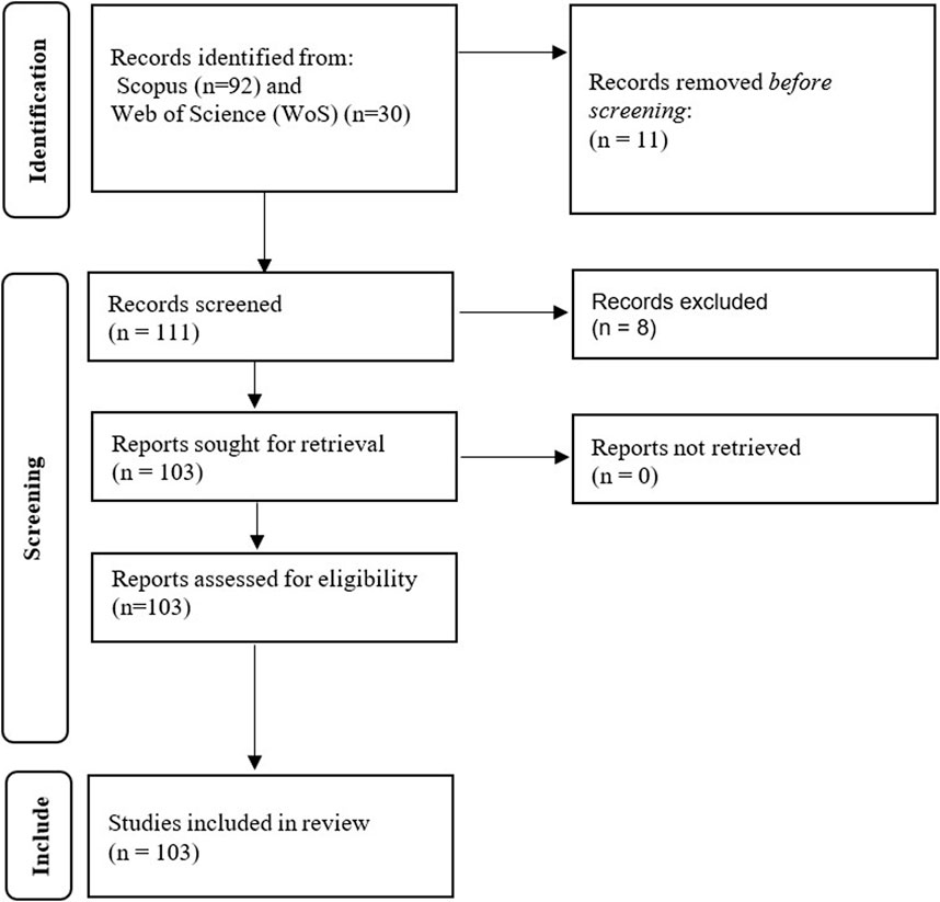
Figure 1. PRISMA diagram showing the workflow used to retrieve the documents for review.
Results
Description of data retrieved from the Scopus and WoS databases
The total number of analyzed published studies from Scopus and Web of Science (WOS) database were 103 documents between 2014 and 2024, originating from 69 diverse sources. The research output in this field has been growing at an annual rate of 18.22%, indicating a significant increase in this field. The evaluation of these documents revealed a total of 527 author appearances averaging about 3 authors per document and 17.49 co-authors per document. Furthermore, there is evidence of international collaboration among authors with 3.883% of the documents having international co-authorship. Table 1 shows the data description of the Scopus and WOS documents.
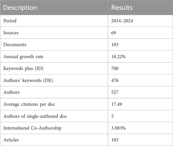
Table 1. Data description of Scopus documents.
Annual scientific production
There has been an oscillation and an overall increasing annual scientific production trend in the past decade (2014–2024) for remote sensing insect pest monitoring studies (Figure 2). The publication output declined in 2015, 2017, 2019 and 2020, respectively. The decline in annual scientific production suggests an inconsistency in remote sensing and insect monitoring research over the years. There is a noticeable increase witnessed from 2021, with the highest number of documents published in the year 2023.
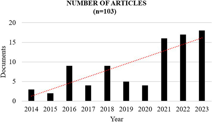
Figure 2. Annual scientific production of remote sensing insect monitoring studies (2014–2024)
Scientific publication distribution and countries collaboration
Figure 3 shows the spatial distribution of the published documents production in remote sensing and insect pest monitoring research. Most articles originated from China (94), followed by the USA (25), India (8), Germany (7), Italy (6), and Spain (4), among others. Several other countries, including Brazil, Belgium, Canada, and Finland, have also made significant contributions with two article publications. Additionally, countries such as Algeria, France, Netherlands, Morocco and South Africa, each had only one publication. However, some parts of Southern America and Africa still lack research outputs in remote sensing and insect pest monitoring.
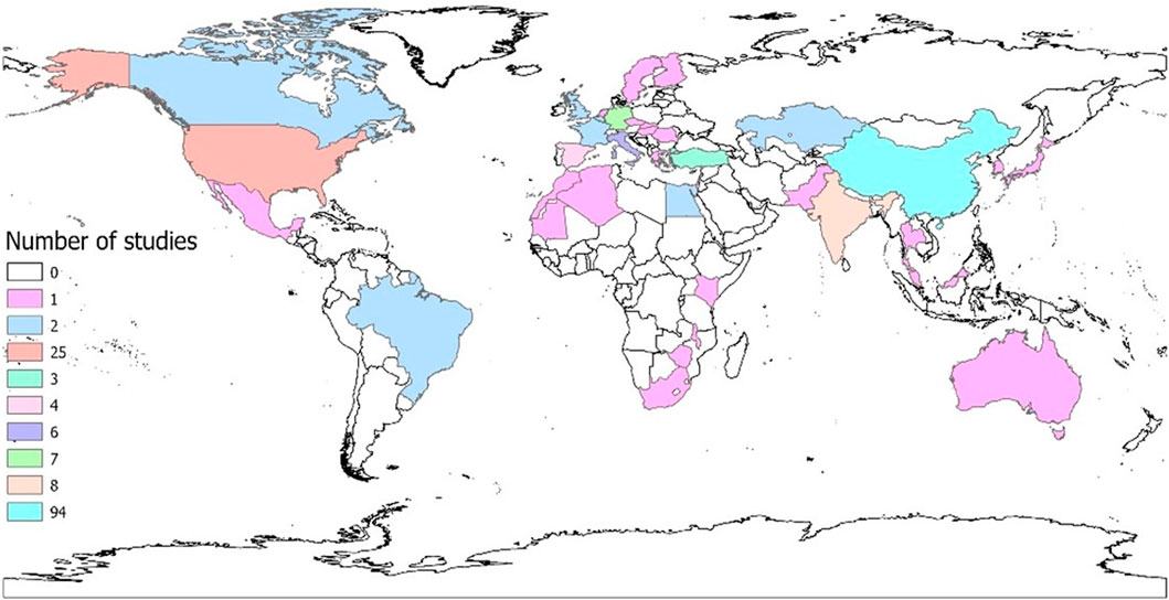
Figure 3. Spatial distribution of studies on the use of remote sensing in the monitoring of insect pests.
Most globally cited articles on remote sensing and insect pest monitoring research
Table 2 summarizes the top 10 globally cited scientific articles on remote sensing of insect pest monitoring research during the survey period. Vanegas et al. (2018) developed a Uncrewed Aerial vehicles (UAV)-based remote sensing methodology to improve pest surveillance in vineyards, specifically targeting grape phylloxera. Their approach combined hyperspectral, multispectral, and RGB sensors with UAV and ground data to create a predictive model for detecting infestations. Kaya and Gürsoy (2023) proposed a novel Deep Learning (DL) approach for plant disease detection by fusing RGB and segmented images, achieving an F1-score of 98.12%. Zhou et al. (2017) investigated the impact of different Grey Level Co-occurrence Matrix (GLCM) parameters on the estimation of Leaf Area Index (LAI) using texture features derived from Quickbird high-resolution satellite imagery. Müllerová et al. (2017) assessed the potential ability of UAV data to map invasive black locust (Robinia pseudoaccacia). On the other hand, Yu et al. (2021) developed a 3D-Res Convutional Neural Network (CNN) model to improve early detection of pine wilt disease (PWD) using UAV-based hyperspectral imagery. This model outperformed others, accurately identifying early infected pine trees, even with limited training. Waldner et al. (2015) created satellite-based greenness maps to detect desert locust habitats using Satellite Pour l'Observation de la Terre (SPOT) and Moderate Resolution Imaging Spectroradiometer (MODIS) data. These maps were more accurate (F1-score = 0.64–0.87) in summer breeding areas but less in winter (F1-score = 0.28–0.40). Escorihuela et al. (2018) developed and validated algorithms to produce a 1 km resolution soil moisture dataset for desert locust management using the DisPATCH methodology applied to Soil Moisture and Ocean Salinity (SMOS) data. They also created a high-resolution (100 m) soil moisture product from Sentinel-1 data, which showed high accuracy and could be integrated into early warning systems for desert locusts. Similarly, Piou et al. (2019) used soil moisture to observe desert locust presence/absence at 1 km resolution. They found that an increase in soil moisture followed by a decrease can predict locust presence 70 days later, improving early warning timing by 3 weeks compared to vegetation imagery. Skawsang et al. (2019) used Artificial Neural Network (ANN), Random Forest (RF) and Multiple Linear Regression (MLR) to forecast brown planthopper (Nilaparvata lugens) using weather and host-plant phenology factors. Lastly, Renier et al. (2015) developed a method using MODIS data to detect vegetation senescence in near-real-time, improving desert locust habitat monitoring.
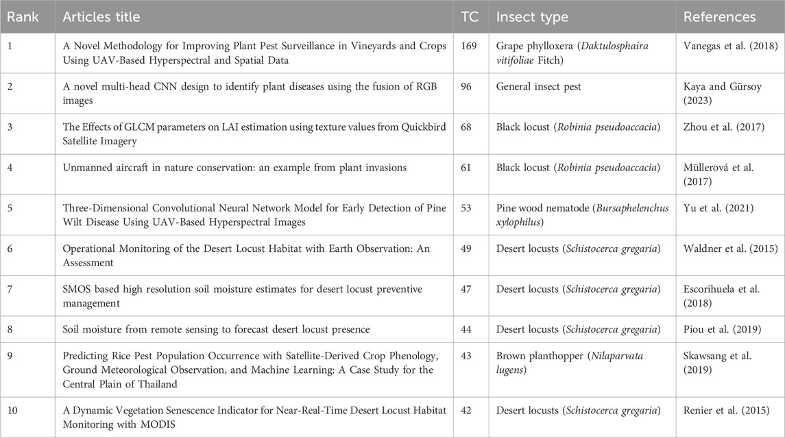
Table 2. Top 10 globally cited published articles on remote sensing of insect pest monitoring research from 2014 to 2024. TC denotes total citations.
Co-occurrence network
The co-occurrence network was carried out in the VOS viewer software (van Eck and Waltman, 2010). This software enables visualization by grouping keywords into interconnected clusters. In these visualizations, lines represent connections between different terms, with the thickness of the lines indicating the frequency of co-occurrence; thicker lines signify a stronger connection (Kirby, 2023). The process of generating a map in VOS viewer involves four steps, (1) choosing a counting approach, either binary or full counting, (2) setting a threshold for the minimum times a term must be appear to be included, (3) determining a relevance score and selecting the most relevant ones based on this score, (4) creating and displaying the final map using the selected terms. The analysis of the co-occurrence network map in Figure 4 categorizes the author’s keywords into three clusters of concepts. The green cluster has the key terms “remote sensing”, “pest control”, “spectroscopy”, “soil moisture”, “desert locust”, “locust”, “agriculture”, and “monitoring”. The connection between these terms indicates the application of remote sensing technologies for detecting and monitoring pest outbreaks, especially related to locusts in agricultural settings. The presence of terms like “spectroscopy” and “soil moisture” suggests using environmental variables in identifying favorable habitats or outbreak areas for pests like the desert locust. The red cluster is characterized by a wide range of keywords, although its primary focus centers around vegetation monitoring, particularly in forest and ecosystem contexts as evidenced by terms like “forest” “, ndvi”, “drought”, “, remote sensing data”, “random forest”, and “ecosystem”. Including “random forests” suggests that machine learning is used for classification or predicting vegetation or drought patterns. The blue cluster has its key terms related to “machine learning”, “satellite imagery”, “support vector machine”, “decision trees” and “classification”. This cluster uses advanced machine learning techniques for processing satellite imagery, particularly classification tasks like identifying pest-infested areas, land cover types or vegetation stress. Algorithms like support vector machines and decision trees suggest a computational focus, where models are trained to detect patterns or classify imagery data for pest-related research.
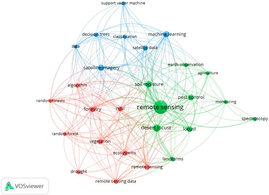
Figure 4. A co-occurrence network showing topical concepts in pest monitoring studies using authors’ keywords.
Species of interest
The majority of the studies as shown in Figure 5 focus on locust, particularly the desert locust (33%) and the general locust category (27%), followed by the black locust (10%), with fewer studies addressing species such as the brown locust (2%), the Italian locust (2%), and the Moroccan locust (2%). Moths represent the second most studied group (19%), including species like Helicoverpa armigera and Spodoptera exigua, while planthoppers (5%), aphids (6%), and beetles (6%) were each covered in fewer studies.
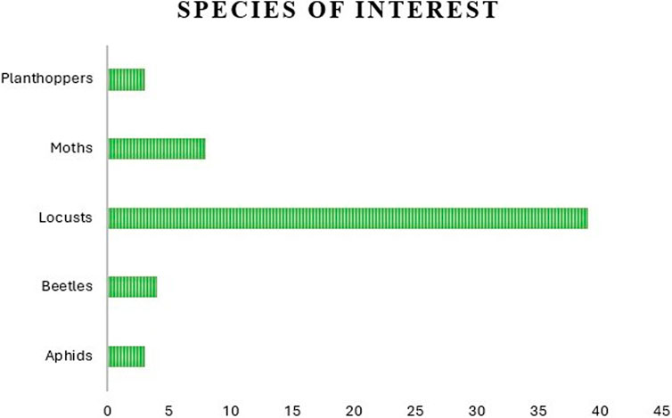
Figure 5. Total number of species categorized by species of interest.
Application areas, common variables and sensors used
Figure 6 illustrates the application areas in remote sensing and insect pest monitoring research during the literature survey period. The commonly highlighted application areas include forest, cropland, grasslands, urban and built-up environments. This study shows that crop-related applications are dominant, constituting 48% of the total number of studies. Other application areas include forest-related studies, which constitute 37%, followed by grassland (10%), urban and built-up (5%), respectively. There is a substantial interest in forest and cropland agricultural research regarding monitoring insect pests using remote sensing technologies. However, grassland, urban areas, and built-up areas are still emerging research avenues among other application areas.
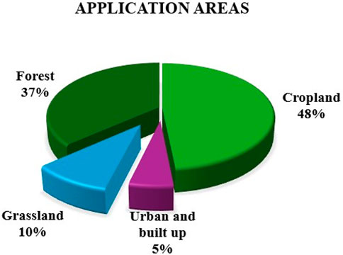
Figure 6. The distribution of application areas in remote sensing and insect pest documents.
Numerous variables are commonly used in remote sensing applications for insect pest monitoring. As shown in Figure 7, temperature and precipitation are the most dominant environmental variables, appearing in approximately 22% and 17% of the reviewed studies. These climatic variables are essential for understanding the driving factors behind insect pest outbreaks. Following these, vegetation indices are widely adopted due to their ability to detect plant stress and changes in canopy condition. The Normalized Difference Vegetation Index (NDVI) and Enhanced Vegetation Index (EVI) are used in over 15% of studies, while indices like Soil Adjusted Vegetation Index (SAVI), Radar Vegetation Index (RVI) contribute roughly 5% each. Other advanced indices, such as Normalized Difference Red Edge (NDRE) and Green Normalized Difference Vegetation Index (GNDVI) were also employed, though less frequently. Soil moisture, land use/land cover (LULC), and drought indices like Standardized Precipitation Index (SPI) and Standardized Precipitation Evapotranspiration Index (SPEI) represent moderate use. This reflects a growing interest in linking soil and drought stress with insect pest outbreaks. Less common variables include elevation, Green Vegetation Fraction (GVF), Normalized Difference Built-up Index (NDBI), Modified Normalized Difference Water Index (MNDWI), each contributing to a small fraction of the literature.
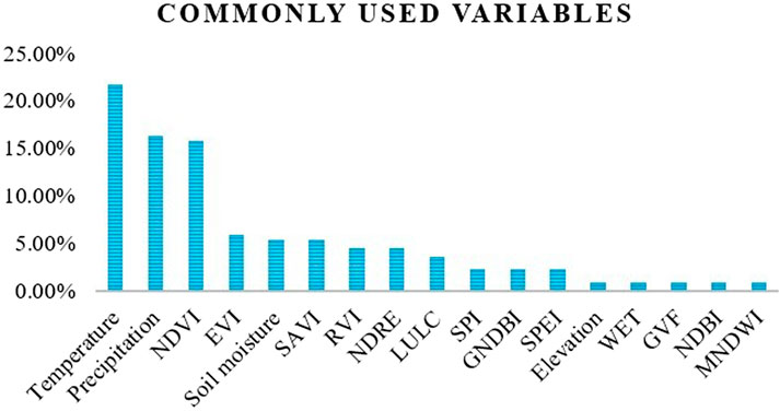
Figure 7. A summary of commonly used variables from the review.
Discussion
Overview of insect monitoring systems
The monitoring of insect pests is a standard activity in Integrated Pest Management (IPM) and early warning systems (Sciarretta and Calabrese, 2019), aiming to assess the presence, abundance, and distribution of pests (Preti et al., 2021). Techniques for monitoring include visual inspections, suction traps, and passive methods, with passive methods like pitfall and sticky traps being the most frequently used (Green et al., 2020). These traps can be chromotropic or baited with attractants like pheromones or food (Preti et al., 2021). Inspections are performed regularly to identify and count insects through remote analysis of captured images, as explored by Ünlü et al. (2019). This manual process requires a high level of expertise, and it is time-consuming, leading to low efficiency, increased labor demands, and delays in data usage (Kariyanna and Sowjanya, 2024). Recent advancements in information and communication technologies, like sensor networks and the Internet of Things, have automated pest monitoring (Vijaya and Vigneswari, 2022). Automated monitoring systems, also known as intelligent systems, consist of a network of wireless sensor nodes strategically positioned to continuously track insect activity at agricultural locations (Rustia and Lin, 2023). This system architecture includes sensor nodes that gather data on insect populations, specifically designed to detect and identify insects. This data is transmitted to a server over the internet for analysis, aiding integrated pest management. Farmers receive this information through a mobile app or web interface, which can provide real-time insect counts for each site, the distribution of various insect species, and decision-making recommendations. These systems improve efficiency by facilitating remote access to trap data and often employ machine learning algorithms for insect identification. For instance, Chen and Lin (2023) created a framework that improved classification accuracy while minimizing manual labelling using Gaussian Mixture Model (GMM) and Convolution Neural Network (CNN) CNN based models. Potamitis et al. (2018), on the other hand, used plastic traps that identify insects by their wing beat frequencies. Genoud et al. (2018) utilized a Light Detection and Ranging (LiDAR) system to differentiate between mosquito species by analyzing their wing beat frequencies using a Bayesian approach. The monitoring system for migrating insects operates differently by utilizing radar technology to track their migration and analyze large-scale movement patterns. This method has been shown to be the most effective for observing insect migration due to its benefits, including a wide detection range and the ability to function at night (Noskov et al., 2021). Moreover, there are several commercially available automated monitoring systems that enable farmers to remotely track pest populations, including Trapview (https://trapview.com/), developed by EFOS d. o.o in Slovenia, which allows for real-time tracking of pest activity; iScout (https://metos.global/en/iscout/), created by Pessl Instruments Ges.m.b.H. in Austria; Z Trap (https://www.winfieldunited.com/news-and-insights/z-trap-system), offered by Spensa Technologies Inc. In the USA and FruitflyAfrica (https://www.fruitfly.co.za/) offered by the Stellenbosch University in South Africa.
Remote sensing sensors for monitoring of insect pests
Satellite imagery provides the ability to continuously monitor surface conditions, especially in remote or inaccessible areas, to enhance ground observations (Adams et al., 2021). Remote sensing technologies have proven increasingly valuable for insect pest monitoring and management, offering an efficient way to automate the surveillance of insect outbreaks over large regions (Alsadik et al., 2024). Such large-scale monitoring would be prohibitively costly and time-intensive if conducted solely through traditional field surveys (Filho et al., 2022).
Optical and thermal sensors for insect pests monitoring
Remote sensing sensors vary in terms of the spatial, spectral, radiometric, and temporal resolutions, often requiring a trade-off between spatial and temporal resolutions (Kganyago et al., 2024) as shown in Table 3. MODerate resolution Imaging Spectroradiometer (MODIS) provides frequent daily data but a course resolution (250 m–1,000 m), while Landsat mission, provides medium-spatial resolutions (<30 m), at a relatively low-temporal resolution (i.e., 16 days). In terms of spectral coverage, the sensors in the optical range (i.e., from 400 to 2,500 nm, also called optical sensors) are dominant and in the case of Landsat mission, can include additional sensors, particularly covering the thermal infrared (TIR) region (i.e., from 8 to 14 µm). The thermal sensors capture radiation that surfaces reflect or emit, allowing for the analysis of the Earth’s surface from a distance (Berger et al., 2022). The spectral resolution of instruments varies based on their application. It can range from panchromatic (a single wide band) and standard red, green, and blue (RGB) cameras (which capture three bands) to multispectral and hyperspectral sensors that can include anywhere from a dozen to hundreds of narrow spectral bands. Insect pest monitoring at regional scales requires high-temporal resolution sensors, which can provide multispectral bands, while more localized monitoring (e.g., field-scale) may require sensors capable of providing both high-spatial and temporal resolutions. In recent times, such sensors (that can provide high-spatial and high-temporal resolutions) are available, enabled by constellations such as Copernicus Sentinels and PlanetScope Doves, which have been hailed as groundbreaking events in remote sensing (Kganyago et al., 2024).
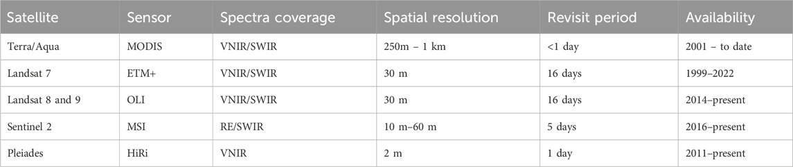
Table 3. A summary of common sensors used in insect pest monitoring.
In the reviewed documents, optical sensors such as MODIS, Landsat 7(ETM+)/8(OLI/TRS) and Sentinel-2 (MSI) were the most predominant in insect pest monitoring. This predominance can be attributed to their ability to provide valuable information about vegetation characteristics, which are closely linked to insect habitat and activity. A key variable derived from these sensors is the Normalized Difference Vegetation Index (NDVI) (Rouse et al., 1974), which helps detect the presence and health of green vegetation, a crucial factor in insect pest monitoring. NDVI is widely applied, including in studies detecting Desert locusts Piou et al. (2013) and examining the impact of prior vegetation growth on locust populations Lawton et al. (2022). Moreover, it is an indicator of photosynthetic activity and defoliation in trees (Soukhovolsky et al., 2023). These optical sensors differ in spatial resolution and temporal resolution. Sentinel-2 has a higher spatial resolution of up to 10 m compared to Landsat and MODIS, which have a spatial resolution of 30 m and 250 m. However, research using Sentinel-2 is limited, due to its shorter data record, which spans from 2016 to the present. In contrast, MODIS was launched in 1999, and Landsat, with its first satellite, i.e., Multi-Spectral Scanner (MSS), launched in 1972, provides long-term data records that extend back several decades. This long-term record is crucial for monitoring vegetation health, growth, and development trends (Adams et al., 2021). In contrast, Sentinel-2 was largely used on forest health assessment. Its red-edge bands are suitable for vegetation health applications related to pest and disease damage detection. Kumbula et al. (2019) mapped the occurrence of the Cossid Moth (Coryphodema tristis) in Eucalyptus Nitens Plantations of Mpumalanga province in South Africa using Sentinel-2 images. Similarly, (Prabhakar et al., 2022), investigated the damage caused by the fall armyworm in farm fields of India using Sentinel-2. Insect feeding activity causes biomass loss and a plant stress response, which can be detected by means of their spectral reflectance. Therefore, effects such as defoliation and plant stress symptoms caused by insects are often easy to detect (Soukhovolsky et al., 2023).
The wide use of MODIS and Landsat can also be attributed to their capability to provide data in the TIR range of the electromagnetic spectrum. According to Messina and Modica (2020), elements in the landscape, including vegetation, soil, and water, emit TIR radiation primarily within the 3.0–14 μm range. The emitted radiation can be converted into surface temperature. Typically, satellite-derived Land Surface Temperature (LST) has been used and its popularity as a critical data source for insect population models has increased over the years. This is because satellite data can provide extensive coverage across large geographic areas, which often overcomes the limitations of ground-based meteorological stations (Blum et al., 2015). These stations are often sparse and separated by significant distances, usually more than 10 km, which can limit the assessment of temperature variations across different landscapes. Other TIR sensors that can be used are Advanced Spaceborne Thermal Emission and Reflection Radiometer (ASTER) and ECOsystem Spaceborne Thermal Radiometer Experiment on Space Station (ECOSTRESS), however, their use in insect pest monitoring has been limited.
Active sensors in insect pest monitoring
Radio Detection and Ranging (RaDAR) is an active sensing technology that uses microwave radiation to detect and characterize objects by analyzing reflected backscatter from emitted pulses (Rhodes et al., 2022). The properties of this backscatter, including wavelengths and polarizations, provide valuable information about the structure and dielectric properties of objects, making RaDAR valuable in fields like entomology. It has been effective in monitoring airborne insects, with studies using weather surveillance systems to track insect pest populations (Van Klink et al., 2022). RaDAR helps understand the navigation behaviors of insects flying hundreds of meters above the ground, even in low-light conditions (Drake et al., 2017). Recent advancements in RaDAR technology have introduced novel techniques for entomological research (Dwivedi et al., 2020). For instance, harmonic radar can track low-flying insects by tagging individuals, although its application is limited to one insect at a time and is most effective in flat landscapes (Maggiora et al., 2019). Vertical-looking radar, on the other hand, is designed for long-term monitoring of high-altitude insects, providing crucial data on large-scale migration patterns. Additionally, upgrades to weather radar systems, particularly dual-polarization (dual-pol) technology, have improved insect detection capabilities. Dual-pol RaDAR transmits and receives signals in both vertical and horizontal planes, making it more effective at identifying insects based on their unique reflections. This improvement is especially useful for monitoring mass insect movements, which were previously challenging to detect with single-polarization systems.
RaDAR operates in different bands, including X-band (3 cm), C-band (5 cm), and S-band (10 cm), each offering unique trade-offs. Smaller wavelengths, such as X-band, are sensitive enough to detect small particles such as insects but have limited range. In contrast, longer wavelengths, such as S-band, are better for large-scale surveillance but less effective for small targets (Bauer et al., 2024). Drake et al. (2017) demonstrated that RaDAR can identify insects by analyzing their radar cross-section (RCS) and polarization patterns, particularly at X-band frequencies (9.4 GHz) revealing that small insects produce consistent polarization patterns, while larger ones exhibit variability. On the other hand, Hao et al. (2020) suggested that the Zenith-Pointing Linear-Polarized Narrow-Angle Conical Scan (ZLC) configuration offers unique capabilities for tracking individual insects and retrieving detailed trajectory information.
LiDAR (Light Detection and Ranging) is another active remote sensing technology that operates in the optical spectrum, offering unique capabilities for insect monitoring and habitat assessment (Song et al., 2020). Unlike RaDAR, which primarily tracks high-altitude insect migrations, LiDAR detects insects at lower altitudes (10–600 m) (Van Klink et al., 2022), making it a suitable tool for studying localized insect activity and interactions with vegetation. One key advantage of LiDAR is its ability to provide high-resolution 3D information about vegetation structure, critical for understanding insect habitats and responses to environmental changes (Karim et al., 2024). For instance, airborne LiDAR is widely used in forest inventory assessments to measure the 3D distribution of vegetation within canopies (White et al., 2016). By capturing structural changes in forest canopies, such as defoliation caused by herbivorous insects, LiDAR data can provide information on the impact of insect infestations on forest health and ecosystem dynamics. Recent advancements in LiDAR technology have further expanded its applications in entomology. Traditional LiDAR systems are limited to single-wavelength sensors in the near-infrared (NIR) spectrum (Fernandez-Diaz et al., 2016). This restricts their potential for species identification and detailed canopy health assessments due to their inability to capture varied backscatter responses and spectral signatures. However, the development of multi-wavelength LiDAR sensors, such as the Optech Titan multispectral LiDAR system, has significantly enhanced the capability of LiDAR in this domain (Hakala et al., 2015). These systems operate across multiple wavelengths, enabling tree-level health assessments and a more comprehensive understanding of vegetation conditions. Airborne hyperspectral LiDAR (AHSL) has also emerged as a valuable tool for monitoring insect-related forest disturbances, allowing researchers to simulate disturbance scenarios and analyze damage locations and stress levels (Zhao et al., 2023). Overall, LiDAR remote sensing provides a transformative approach to insect monitoring, offering scalable, high-resolution data for assessing both insect activity and its impact on ecosystems. Compared to traditional field surveys, which are timely and labor-intensive, LiDAR presents a more efficient and realistic method for monitoring insect-induced defoliation and other forest disturbances.
UAVs for insect monitoring
Aerial imaging has become increasingly popular for data collection with the rise of Uncrewed Aerial Vehicles (UAVs), commonly known as drones. These include multi-rotor, fixed wing, and hybrid systems (Osco et al., 2021). UAVs offer distinct advantages over traditional orbital sensing methods, operating at lower altitudes with minimal atmospheric interference and reduced costs. As a result, they are widely used in both commercial and scientific applications (Osco et al., 2021). While conventional UAVs are equipped with RGB cameras limited to the visible spectrum, modern UAVs feature advanced sensors such as multispectral cameras. For instance, (Westbrook et al., 2016), used a fixed-wing UAV equipped with RGB and near-infrared cameras to identify individual cotton plants, which serve as habitats for boll weevils. These cameras achieved a remarkably low misclassification rate of 0.125 and 0.146. Additionally, UAVs can be equipped with hyperspectral and thermal cameras, as well as lightweight LiDAR, enabling efficient and accessible data collection across diverse remote sensing applications (Yao et al., 2019). Yu et al. (2021) further demonstrated the potential of UAV-based hyperspectral imaging for detecting Pine Wilt Disease.
Applications of machine learning algorithms in insect pest monitoring
Machine Learning (ML) is a branch of artificial intelligence that enables systems to learn from data, identify patterns and make decisions without explicit programming (Safonova et al., 2023). It excels in analyzing complex systems where theoretical knowledge is lacking, but data is abundant. ML has transformed pest management by offering robust algorithms that can handle complex datasets and improve predictive accuracy. ML enhances species distribution by improving predictive accuracy, handling complex variable interactions, and managing large ecological datasets efficiently. Often, ML algorithms outperform traditional statistical models when it comes to predictive performance (Breiman, 2001). For instance, General Linear Regression (GLM) requires variables to follow normality and linearity, necessitating transformation (Ryo, 2022), while ML algorithms automatically identify nonlinearity without such requirements (Ryo and Rillig, 2017). These algorithms adapt and improve their performance as they process more data (Taye, 2023). The ML algorithms can be classified into three major groups: tree-based, kernel and deep-learning approaches (Rivera-Caicedo et al., 2017).
Common tree-based approaches include Random Forest (RF) and eXtreme Gradient Boosting (XGBoost). RF combines regression and classification using a resampling method called bagging, creating multiple decision trees from randomly selected subsets, and determining the final prediction through majority voting or averaging (Gomes et al., 2017; Breiman, 2001). RF offers high prediction accuracy while mitigating overfitting and handling noise (Belgiu and Drăgu, 2016). eXtreme Gradient Boost (XGB) is a tree-based method that builds trees sequentially, with each new tree aiming to correct the errors of the previous one. This iterative approach aims to rectify previous errors, ultimately enhancing the overall predictive accuracy of the model (Lv et al., 2021).
In contrast, Deep Learning (DL) approaches rely on Artificial Neural Networks (ANNs) with multiple layers to learn complex patterns in data. Each artificial neuron has a weight and bias associated with neurons from the previous layer, with connections acting as weights for inputs (Achieng, 2019). An ANN contains an input layer that receives data, a final output layer that produces predictions, and several hidden layers where target outputs are not explicitly defined (Kala, 2024).
DL models eliminate the need for manual feature engineering, as they can learn complex patterns from raw labelled image data. By processing numerous labelled images, these models enable computers to recognize and understand visual information with speed, robustness, and high accuracy (Safonova et al., 2023). Insect species can appear similar, especially when they are at similar stages of development, making traditional manual identification less accurate and more time-consuming (Høye et al., 2021). Visual-based machine learning algorithms effectively address this issue, and recent advancements have made insect pest classification from images a significant research focus (Gao et al., 2024).
Numerous automated recognition systems utilizing machine learning have been developed for insect pest management in agriculture (Gomes and Borges, 2022). Kalfas et al. (2022) detected Drosophila suzukii by utilizing an optical sensor to record wingbeats and training Convolutional Neural Network (CNN) classifiers to distinguish it from Drosophila melanogaster. Their “Inceptionfly” model achieved a balanced accuracy of 92.1% and 91.7% on independent datasets, facilitating early pest detection. CNNs are widely utilized deep learning models due to their ability to automatically extract features and handle large datasets (Zhang et al., 2019). Similarly, Maharlooei et al. (2017) used image processing to detect and count soybean aphids (Aphis glycines), a significant pest in North America. Park et al. (2023) explored UAV’s and image analysis to assess a beet armyworm (S. exigua) outbreak in soybean fields in South Korea.
Modelling has been extensively utilized for forecasting species range (de Oliveira et al., 2024), and ecological niches (Carrell et al., 2023) under the present and projected climate scenarios. For many species, travel distances are determined by vegetation. Dkhili et al. (2019) studies how vegetation arrangement affects locust collective movement. Habitat suitability modelling is a technique used to identify areas suitable for the survival of populations and identification of the environmental conditions necessary for those areas (Fadda et al., 2023). As ectotherms, insects’ life history is significantly affected by temperature. For instance, locusts digest food more slowly at low temperatures, but as their body temperature rises, digestion accelerates, allowing for more energy absorption (Harrison and Fewell, 1995). Consequently, global warming can impact on the spatio-temporal dynamics of insect populations, with factors like humidity, temperature, precipitation, and wind also influencing suitable habitats. Régnier et al. (2023) observed that climate change could either benefit or hinder pest development, depending on the optimal temperature for species growth.
Lessons for Brown locust infestations monitoring in South Africa
Plague locusts have historically posed a significant economic threat to crops and grazing areas, in South Africa for over 380 years (Price, 2021). The Locustana pardalina (Brown locust) is particularly notorious among other locust pests in South Africa such as the Locusta migratoria migratorioides (African migratory locust), the Nomadacris septemfasciata (red locust) and the Schistocerca gregaria flaviventris (southern African desert locust). With its efficient feeding habits, a swarm of locusts spanning 20 km2 and averaging 60 million adults per km2 can consume as much in 1 day as would sustain 2,500 people for an entire year (Food and Agriculture Organization of the United Nations, 2020).
These swarms threaten sheep grazing land in the Nama Karoo and irrigated crops, with key maize and wheat areas at risk from invasions emanating from the eastern Karoo (Price, 2021). Over the last century, outbreaks of Brown locusts have created serious challenges that have necessitated extensive use of control measures in order to safeguard food security (Price, 2023). The repeated application of pesticides has not only harmed the environment but has also raised concerns about resistance in locust populations, complicating future management. To mitigate these risks, there is an urgent need for monitoring methods. Utilizing remote sensing technologies can provide a more sustainable approach to tracking Brown locust populations enabling early outbreak detection and targeted interventions that minimize ecological damage and safeguard food security in South Africa.
The review of literature showed that only 2% of the insect pest studies focused on the Brown Locust, which emphasizes the need for further research on this species. Additionally, remote sensing offers a powerful tool for early detection, especially in tracking changes in vegetation that indicate potential breeding grounds for locusts (Klein et al., 2021). The reviewed studies show a strong reliance on optical sensors like Landsat 7 (ETM+)/8 (OLI/TRS) and MODIS; therefore, exploring other sensors such as Sentinel-2 (MSI), PlanetScope Doves and Worldview-4 would offer better precision in identifying locust breeding grounds, particularly in smaller, more localized areas. Very-High-resolution sensors such as RapidEye, PlanetScope Doves and Worldview-4 provide greater detail, allowing for more accurate monitoring of environmental changes that signal locust population growth. However, the inflated cost of acquiring such satellite data can be a significant barrier. To overcome this, partnerships with governmental and international entities could subsidize the cost, making the technology more accessible to local researchers and pest control initiatives. For example, Kganyago and Mhangara (2019) showed that Single License-Multi-User Agreement (SLMA) between satellite data providers and African space agencies, e.g., South African National Space Agency and Airbus Defense and Space SPOT agreement, may increase affordability and accessibility of very-high-resolution data. Incorporating additional vegetation indices beyond the commonly used NDVI, such as the red-edge indices, could further improve the detection and monitoring of locust habitats. These indices overcome limitations of traditional VNIR indices and correlate better with biophysical and biochemical parameters of vegetation, thus offer a deeper understanding of vegetation health, which directly impacts locust behavior and breeding patterns. Remote sensing, when combined with predictive modelling powered by machine learning, can enhance the forecasting ability of locust outbreaks. These models analyze key environmental factors like rainfall, soil moisture, and vegetation growth to predict potential locust activity, providing critical early warnings that enable farmers and policymakers to act before infestations reach damaging levels.
In South Africa, there are commercially available insect pest monitoring systems, but none specifically designed for locusts. These systems include Koppert (https://www.koppert.co.za/), Fruit Fly Africa (https://www.fruitfly.co.za/), and SMARTSENZ (https://smartsenzipm.co.za/). Fruit Fly Africa is not an automated system; instead, it uses baits to eliminate female fruit flies before they can mate, thereby limiting the reproduction of the adult population. In contrast, Koppert is an automated system that aids in detecting insect pests through a mobile application. The monitoring of brown locusts would benefit from an automated system, which would also facilitate early outbreak warnings. Automated monitoring systems that utilize remote sensing data and machine learning algorithms could be implemented for real-time tracking of locust pests. These systems enable automated data collection, minimizing the need for labor-intensive manual monitoring and providing farmers with timely information for effective pest control. Additionally, developing mobile applications that deliver alerts, locust distribution maps, and control recommendations would be highly beneficial. This would help farmers, especially in remote areas, to respond promptly to locust threats. By adopting these strategies, South Africa can improve its capacity to monitor Brown locust infestations, safeguarding crops and securing food supplies.
Conclusion
This study reviewed 103 documents from Scopus and Web of Science, revealing significant advancements and trends over the past decade (2014–2024). Specifically, a bibliometric analysis showed a steady growth in research output, with an annual increase of 6.68%. The USA and China lead research contributions in insect pest monitoring. The limited collaboration involving developing countries suggests a potential area for growth in collaborative research. Forest-related studies dominate, followed by cropland applications, while grasslands and urban environments remain underexplored. Although, climate variables i.e temperature and precipitation are mostly used, there is a need to explore other variables which may explain the occurrences of the pest infestations. Landsat, MODIS, and Sentinel-2 emerged as the most utilized sensors, with NDVI being the primary derived variable. Advanced technologies, including machine learning and deep learning, are increasingly integrated to improve pest detection and monitoring. For Brown locust monitoring in South Africa, the review recommends technology-driven methods using remote sensing and predictive modelling. South Africa can enhance its capacity for monitoring and early detection while minimizing environmental impacts, as the infestation management can be more targeted. This strategic integration will not only protect and improve crops and livestock productivity, but it will also promote sustainable agriculture in the country. Moving forward, fostering partnerships to reduce costs and increase accessibility to these advanced monitoring technologies will be essential for protecting agricultural livelihoods against the growing threats of locust outbreaks. This study contributes essential information about progress in remote sensing of insect pests in the last decade, identifying regions and themes that are limitedly researched, thus providing research gaps to direct future research.
Data availability statement
The original contributions presented in the study are included in the article/supplementary material, further inquiries can be directed to the corresponding authors.
Author contributions
KM: Conceptualization, Methodology, Writing – original draft. MK: Conceptualization, Methodology, Supervision, Writing – original draft, Writing – review and editing. CM: Supervision, Writing – review and editing. RP: Supervision, Writing – review and editing. LN: Writing – review and editing.
Funding
The author(s) declare that financial support was received for the research and/or publication of this article. This research was funded by the ARC-PHP and DALRRD.
Acknowledgments
The bibliometric data used in this review are from the Scopus database and Web of Science (WoS). The authors would like to thank the ARC-PHP and DALRRD for the funding of this research and the University of Johannesburg, Department of Geography, Environmental Management, and Energy studies.
Conflict of interest
The authors declare that the research was conducted in the absence of any commercial or financial relationships that could be construed as a potential conflict of interest.
Generative AI statement
The author(s) declare that no Generative AI was used in the creation of this manuscript.
Publisher’s note
All claims expressed in this article are solely those of the authors and do not necessarily represent those of their affiliated organizations, or those of the publisher, the editors and the reviewers. Any product that may be evaluated in this article, or claim that may be made by its manufacturer, is not guaranteed or endorsed by the publisher.
References
Achieng, K. O. (2019). Modelling of soil moisture retention curve using machine learning techniques: artificial and deep neural networks vs support vector regression models. Comput. Geosciences 133, 104320. doi:10.1016/J.CAGEO.2019.104320
Adams, E. C., Parache, H. B., Cherrington, E., Ellenburg, W. L., Mishra, V., Lucey, R., et al. (2021). Limitations of remote sensing in assessing vegetation damage due to the 2019–2021 desert locust upsurge. Front. Clim. 3. 714273. doi:10.3389/fclim.2021.714273
Alsadik, B., Ellsäßer, F. J., Awawdeh, M., Al-Rawabdeh, A., Almahasneh, L., Oude Elberink, S., et al. (2024). Remote sensing technologies using UAVs for pest and disease monitoring: a review centered on date palm trees. Remote Sens. 16 (23), 4371. doi:10.3390/RS16234371
Bauer, S., Tielens, E. K., and Haest, B. (2024). Monitoring aerial insect biodiversity: a radar perspective. Philosophical Trans. R. Soc. B Biol. Sci. 379 (1904), 20230113. doi:10.1098/RSTB.2023.0113
Belgiu, M., and Drăgu, L. (2016). Random forest in remote sensing: a review of applications and future directions. ISPRS J. Photogrammetry Remote Sens. 114, 24–31. doi:10.1016/J.ISPRSJPRS.2016.01.011
Berger, K., Machwitz, M., Kycko, M., Kefauver, S. C., Van Wittenberghe, S., Gerhards, M., et al. (2022). Multi-sensor spectral synergies for crop stress detection and monitoring in the optical domain: a review. Remote Sens. Environ. 280, 113198. doi:10.1016/j.rse.2022.113198
Blum, M., Lensky, I. M., Rempoulakis, P., and Nestel, D. (2015). Modeling insect population fluctuations with satellite land surface temperature. Ecol. Model. 311, 39–47. doi:10.1016/j.ecolmodel.2015.05.005
Brockerhoff, E. G., Corley, J. C., Jactel, H., Miller, D. R., Rabaglia, R. J., and Sweeney, J. (2023). Monitoring and surveillance of forest insects. For. Entomol. Pathol. 1, 669–705. doi:10.1007/978-3-031-11553-0_19/FIGURES/8
Carrell, J. D., Phinney, A. I., Mueller, K., and Bean, B. (2023). Multiscale ecological niche modeling exhibits varying climate change impacts on habitat suitability of Madrean Pine-Oak trees. Front. Ecol. Evol. 11, 1086062. doi:10.3389/FEVO.2023.1086062/BIBTEX
Castex, V., Beniston, M., Calanca, P., Fleury, D., and Moreau, J. (2018). Pest management under climate change: the importance of understanding tritrophic relations. Sci. Total Environ. 616–617, 397–407. doi:10.1016/J.SCITOTENV.2017.11.027
Chakraborty, S., and Newton, A. C. (2011). Climate change, plant diseases and food security: an overview. Plant Pathol. 60 (1), 2–14. doi:10.1111/J.1365-3059.2010.02411.X
Chen, C. K., and Lin, T.Te. (2023). An automated online learning framework for insect pest image classification model enhancement. ASABE Annu. Int. Meet. 1. doi:10.13031/AIM.202300292
Clavijo-Baquet, S., Orellana, M. J., Sabat, P., and Bozinovic, F. (2022). How do ectotherms perform in cold environments? Physiological and life-history traits in an Andean viviparous lizard. Front. Ecol. Evol. 10, 974968. doi:10.3389/FEVO.2022.974968/BIBTEX
Colinet, H., Sinclair, B. J., Vernon, P., and Renault, D. (2015). Insects in fluctuating thermal environments. Annu. Rev. Entomol. 60, 123–140. doi:10.1146/annurev-ento-010814-021017
Cressman, K. (2013). Role of remote sensing in desert locust early warning. J. Appl. Remote Sens. 7 (1), 075098. doi:10.1117/1.JRS.7.075098
Cruz-Esteban, S., Rojas, J. C., and Malo, E. A. (2020). A pheromone lure for catching fall armyworm males (Lepidoptera: noctuidae) in Mexico. Acta Zoológica Mex. (N.S.) 36 (1), 1–11. doi:10.21829/azm.2020.3612271
del Águila, I. M., Cañadas, J., and Túnez, S. (2015). Decision making models embedded into a web-based tool for assessing pest infestation risk. Biosyst. Eng. 133, 102–115. doi:10.1016/J.BIOSYSTEMSENG.2015.03.006
de Oliveira, K., Novaes, R. L. M., Weber, M. M., and Moratelli, R. (2024). Forecasting climate change impacts on neotropical Myotis: insights from ecological niche models for conservation strategies. Ecol. Evol. 14 (6), e11419. doi:10.1002/ECE3.11419
Dkhili, J., Maeno, K. O., Idrissi Hassani, L. M., Ghaout, S., and Piou, C. (2019). Effects of starvation and vegetation distribution on locust collective motion. J. Insect Behav. 32 (3), 207–217. doi:10.1007/s10905-019-09727-8
Drake, V. A., Chapman, J. W., Lim, K. S., Reynolds, D. R., Riley, J. R., and Smith, A. D. (2017). Ventral-aspect radar cross sections and polarization patterns of insects at X band and their relation to size and form. Int. J. Remote Sens. 38 (18), 5022–5044. doi:10.1080/01431161.2017.1320453
Dwivedi, M., Shadab, M. H., and Santosh, V. R. (2020). “Insect pest detection, migration and monitoring using radar and LiDAR systems,” in Innovative pest management approaches for the 21st century, eds. A. Chakravarthy, (Singapore: Springer).
Escorihuela, M. J., Merlin, O., Stefan, V., Moyano, G., Eweys, O. A., Zribi, M., et al. (2018). SMOS based high resolution soil moisture estimates for desert locust preventive management. Remote Sens. Appl. Soc. Environ. 11, 140–150. doi:10.1016/j.rsase.2018.06.002
Fadda, L. A., Murúa, M. G., Casmuz, A. S., Vera, M. A., and Lira-Noriega, A. (2023). Potential distribution of Melanagromyza sojae in South America and current situation in Argentina. Entomologia Exp. Appl. 171 (8), 621–636. doi:10.1111/eea.13302
FAO, IFAD, UNICEF, WFP and WHO. (2022). The State of Food Security and Nutrition in the World 2022. Repurposing food and agricultural policies to make healthy diets more affordable. Rome, Italy: FAO. Available online at: https://doi.org/10.4060/cc0639en (accessed on November 10, 2024).
Fernandez-Diaz, J. C., Carter, W. E., Glennie, C., Shrestha, R. L., Pan, Z., Ekhtari, N., et al. (2016). Capability assessment and performance metrics for the titan multispectral mapping lidar. Remote Sens. 8 (11), 936. doi:10.3390/RS8110936
Filho, F. H. I., Pazini, J. de B., de Medeiros, A. D., Rosalen, D. L., and Yamamoto, P. T. (2022). Assessment of injury by four major pests in soybean plants using hyperspectral proximal imaging. Agronomy 12 (7), 1516. doi:10.3390/AGRONOMY12071516/S1
Fleeger, J. W., Carman, K. R., and Nisbet, R. M. (2003). Indirect effects of contaminants in aquatic ecosystems. Sci. Total Environ. 317, 207–233. doi:10.1016/S0048-9697(03)00141-4
Food and Agriculture Organization of the United Nations (2020). Locust outbreaks threaten food security in southern Africa. Available online at: https://www.fao.org/africa/news-stories/news-detail/Locust-outbreaks-threaten-food-security-in-southern-Africa/en. (accessed November 10, 2024).
Gao, Y., Xue, X., Qin, G., Li, K., Liu, J., Zhang, Y., et al. (2024). Application of machine learning in automatic image identification of insects - a review. Ecol. Inf. 80, 102539. doi:10.1016/J.ECOINF.2024.102539
Genoud, A. P., Basistyy, R., Williams, G. M., and Thomas, B. P. (2018). Optical remote sensing for monitoring flying mosquitoes, gender identification and discussion on species identification. Appl. Phys. B Lasers Opt. 124 (3), 46–11. doi:10.1007/s00340-018-6917-x
Gomes, H. M., Bifet, A., Read, J., Barddal, J. P., Enembreck, F., Pfharinger, B., et al. (2017). Adaptive random forests for evolving data stream classification. Mach. Learn. 106 (9–10), 1469–1495. doi:10.1007/S10994-017-5642-8/FIGURES/6
Gomes, J. C., and Borges, D. L. (2022). Insect pest image recognition: a few-shot machine learning approach including maturity stages classification. Agronomy 12 (8), 1733. doi:10.3390/AGRONOMY12081733
Green, K. K., Stenberg, J. A., and Lankinen, Å. (2020). Making sense of integrated pest management (IPM) in the light of evolution. Evol. Appl. 13 (8), 1791–1805. doi:10.1111/EVA.13067
Hakala, T., Nevalainen, O., Kaasalainen, S., and Mäkipää, R. (2015). Technical Note: multispectral lidar time series of pine canopy chlorophyll content. Biogeosciences 12 (5), 1629–1634. doi:10.5194/BG-12-1629-2015
Hao, Z., Drake, V. A., Taylor, J. R., and Warrant, E. (2020). Insect target classes discerned from entomological radar data. Remote Sens. 12 (4), 673. doi:10.3390/RS12040673
Harrison, J. F., and Fewell, J. H. (1995). Thermal effects on feeding behavior and net energy intake in a grasshopper experiencing large diurnal fluctuations in body temperature. Physiol. Zool. 68 (3), 453–473. doi:10.1086/PHYSZOOL.68.3.30163779
Høye, T. T., Ärje, J., Bjerge, K., Hansen, O. L. P., Iosifidis, A., Leese, F., et al. (2021). Deep learning and computer vision will transform entomology. Proc. Natl. Acad. Sci. U. S. A. 118 (2), e2002545117. doi:10.1073/PNAS.2002545117/SUPPL_FILE/PNAS.2002545117.SAPP.PDF
Kala, R. (2024). “An introduction to machine learning and deep learning,” in Autonomous Mobile Robots. Cambridge, MA: Academic Press, 569–625.
Kalfas, I., De Ketelaere, B., Beliën, T., and Saeys, W. (2022). Optical identification of fruitfly species based on their wingbeats using convolutional neural networks. Front. Plant Sci. 13, 812506. doi:10.3389/fpls.2022.812506
Karim, M. R., Reza, M. N., Jin, H., Haque, M. A., Lee, K. H., Sung, J., et al. (2024). Application of LiDAR sensors for crop and working environment recognition in agriculture: a review. Remote Sens. 16 (24), 4623. doi:10.3390/RS16244623
Kariyanna, B., and Sowjanya, M. (2024). Unravelling the use of artificial intelligence in management of insect pests. Smart Agric. Technol. 8, 100517. doi:10.1016/J.ATECH.2024.100517
Kaur, R., Mavi, G. K., Raghav, S., and Khan, I. (2019). Pesticides classification and its impact on environment. Int. J. Curr. Microbiol. Appl. Sci. 8 (03), 1889–1897. doi:10.20546/ijcmas.2019.803.224
Kaya, Y., and Gürsoy, E. (2023). A novel multi-head CNN design to identify plant diseases using the fusion of RGB images. Ecol. Inf. 75, 101998. doi:10.1016/j.ecoinf.2023.101998
Kganyago, M., Adjorlolo, C., Mhangara, P., and Tsoeleng, L. (2024). Optical remote sensing of crop biophysical and biochemical parameters: an overview of advances in sensor technologies and machine learning algorithms for precision agriculture. Comput. Electron. Agric. 218, 108730. doi:10.1016/J.COMPAG.2024.108730
Kganyago, M., and Mhangara, P. (2019). The role of African emerging space agencies in earth observation capacity building for facilitating the implementation and monitoring of the African development agenda: the case of African earth observation program. ISPRS Int. J. Geo-Information 8 (7), 292–323. doi:10.3390/ijgi8070292
Kirby, A. (2023). Exploratory bibliometrics: using VOSviewer as a preliminary research tool. Publications 11 (1), 10. doi:10.3390/PUBLICATIONS11010010
Klein, I., Oppelt, N., and Kuenzer, C. (2021). Application of remote sensing data for locust research and management—a review. Insects 12 (3), 233. doi:10.3390/INSECTS12030233
Kumbula, S. T., Mafongoya, P., Peerbhay, K. Y., Lottering, R. T., and Ismail, R. (2019). Using Sentinel-2 multispectral images to map the occurrence of the Cossid Moth (Coryphodema tristis) in Eucalyptus nitens plantations of Mpumalanga, South Africa. Remote Sens. 11 (3), 278. doi:10.3390/rs11030278
Latchininsky, A. V. (2013). Locusts and remote sensing: a review. J. Appl. Remote Sens. 7 (1), 075099. doi:10.1117/1.JRS.7.075099
Lawton, D., Scarth, P., Deveson, E., Piou, C., Spessa, A., Waters, C., et al. (2022). Seeing the locust in the swarm: accounting for spatiotemporal hierarchy improves ecological models of insect populations. Ecography 2022 05763. doi:10.1111/ecog.05763
Lima, M. C. F., Leandro, M. E. D. de A., Valero, C., Coronel, L. C. P., and Bazzo, C. O. G. (2020). Automatic detection and monitoring of insect pests—a review. Agric. Switz. 10 (5), 161. doi:10.3390/AGRICULTURE10050161
Lin, H. I., Yu, Y. Y., Wen, F. I., and Liu, P. T. (2022). Status of food security in east and southeast Asia and challenges of climate change. Climate 10 (3), 40. doi:10.3390/CLI10030040
Lv, C. X., An, S. Y., Qiao, B. J., and Wu, W. (2021). Time series analysis of hemorrhagic fever with renal syndrome in mainland China by using an XGBoost forecasting model. BMC Infect. Dis. 21 (1), 1–13. doi:10.1186/S12879-021-06503-Y/TABLES/5
Maggiora, R., Saccani, M., Milanesio, D., and Porporato, M. (2019). An innovative harmonic radar to track flying insects: the case of vespa velutina. Sci. Rep. 9, 11964–12010. doi:10.1038/s41598-019-48511-8
Maharlooei, M., Sivarajan, S., Bajwa, S. G., Harmon, J. P., and Nowatzki, J. (2017). Detection of soybean aphids in a greenhouse using an image processing technique. Comput. Electron. Agric. 132, 63–70. doi:10.1016/j.compag.2016.11.019
Malaguit, J. C., Mendoza, V. M. P., Tubay, J. M., and Mata, M. A. E. (2023). Identifying patterning behavior in a plant infestation of insect pests. Math. Biosci. 362, 109032. doi:10.1016/j.mbs.2023.109032
Messina, G., and Modica, G. (2020). Applications of UAV thermal imagery in precision agriculture: state of the art and future research outlook. Remote Sens. 12 (9), 1491. doi:10.3390/RS12091491
Montgomery, G. A., Belitz, M. W., Guralnick, R. P., and Tingley, M. W. (2021). Standards and best practices for monitoring and benchmarking insects. Front. Ecol. Evol. 8, 579193. doi:10.3389/FEVO.2020.579193/XML/NLM
Müllerová, J., Bartaloš, T., Brůna, J., Dvořák, P., and Vítková, M. (2017). Unmanned aircraft in nature conservation: an example from plant invasions. Int. J. Remote Sens. 38 (8–10), 2177–2198. doi:10.1080/01431161.2016.1275059
Noskov, A., Bendix, J., and Friess, N. (2021). A review of insect monitoring approaches with special reference to radar techniques. Sensors 21 (4), 1474–1523. doi:10.3390/s21041474
Osco, L. P., Marcato Junior, J., Marques Ramos, A. P., de Castro Jorge, L. A., Fatholahi, S. N., de Andrade Silva, J., et al. (2021). A review on deep learning in UAV remote sensing. Int. J. Appl. Earth Observat. Geoinformat. 102, 102456. doi:10.1016/J.JAG.2021.102456
Pachkin, A., Kremneva, O., Leptyagin, D., Ponomarev, A., and Danilov, R. (2022). Light traps to study insect species diversity in soybean crops. Agronomy 12 (10), 2337. doi:10.3390/AGRONOMY12102337
Park, Y. L., Naharki, K., Karimzadeh, R., Seo, B. Y., and Lee, G. S. (2023). Rapid assessment of insect pest outbreak using drones: a case study with Spodoptera exigua (hübner) (Lepidoptera: noctuidae) in soybean fields. Insects 14 (6), 555. doi:10.3390/insects14060555
Pedersen, S. M., and Lind, K. M. (2017). “Precision agriculture – from mapping to site-specific application,” in Precision Agriculture: Technology and Economic Perspectives. Progress in Precision Agriculture, eds. S. Pedersen, K. Lind (Cham, Switzerland: Springer).
Piou, C., Gay, P.-E., Benahi, A. S., Babah Ebbe, M. A. O., Chihrane, J., Ghaout, S., et al. (2019). Soil moisture from remote sensing to forecast desert locust presence. J. Appl. Ecol. 56 (4), 966–975. doi:10.1111/1365-2664.13323
Piou, C., Lebourgeois, V., Benahi, A. S., Bonnal, V., Jaavar, M. el H., Lecoq, M., et al. (2013). Coupling historical prospection data and a remotely-sensed vegetation index for the preventative control of Desert locusts. Basic Appl. Ecol. 14 (7), 593–604. doi:10.1016/j.baae.2013.08.007
Potamitis, I., Rigakis, I., Vidakis, N., Petousis, M., and Weber, M. (2018). Affordable bimodal optical sensors to spread the use of automated insect monitoring. J. Sensors 2018 (1), 1–25. doi:10.1155/2018/3949415
Prabhakar, M., Gopinath, K. A., Kumar, N. R., Thirupathi, M., Sravan, U. S., Kumar, G. S., et al. (2022). Detecting the invasive fall armyworm pest incidence in farm fields of southern India using Sentinel-2A satellite data. Geocarto Int. 37 (13), 3801–3816. doi:10.1080/10106049.2020.1869330
Preti, M., Verheggen, F., and Angeli, S. (2021). Insect pest monitoring with camera-equipped traps: strengths and limitations. J. Pest Sci. 94 (2), 203–217. doi:10.1007/S10340-020-01309-4/TABLES/2
Price, R. (2021). Alternative strategies for controlling the brown locust, locustana pardalina (Walker). Agronomy 11 (11), 2212. doi:10.3390/agronomy11112212
Price, R. E. (2023). Invasions and local outbreaks of four species of plague locusts in South Africa: a historical review of outbreak dynamics and patterns. Insects 14 (11), 846. doi:10.3390/insects14110846
Rano, S. H., Afroz, M., and Rahman, M. M. (2022). Application of gis on monitoring agricultural insect pests: a review. Rev. Food Agric. 3 (1), 19–23. doi:10.26480/rfna.01.2022.19.23
Régnier, B., Legrand, J., Calatayud, P.-A., and Rebaudo, F. (2023). Developmental differentiations of major maize stemborers due to global warming in temperate and tropical climates. Insects. 14 (1), 51. doi:10.3390/insects14010051
Renier, C., Waldner, F., Jacques, D. C., Babah Ebbe, M. A., Cressman, K., and Defourny, P. (2015). A dynamic vegetation senescence indicator for near-real-time desert locust habitat monitoring with MODIS. Remote Sens. 7 (6), 7545–7570. doi:10.3390/rs70607545
Rhodes, M. W., Bennie, J. J., Spalding, A., ffrench-Constant, R. H., and Maclean, I. M. D. (2022). Recent advances in the remote sensing of insects. Biol. Rev. 97 (1), 343–360. doi:10.1111/BRV.12802
Ribeiro, J. C., Morais, R., Sousa, J. J., Cunha, A. A., Teixeira, A. C., Ribeiro, J., et al. (2023). A systematic review on automatic insect detection using deep learning. Agriculture 13 (3), 713. doi:10.3390/AGRICULTURE13030713
Rivera-Caicedo, J. P., Verrelst, J., Muñoz-Marí, J., Camps-Valls, G., and Moreno, J. (2017). Hyperspectral dimensionality reduction for biophysical variable statistical retrieval. ISPRS J. Photogrammetry Remote Sens. 132, 88–101. doi:10.1016/j.isprsjprs.2017.08.012
Rouse, J. W., Hass, R. H., Schell, J. A., Deering, D. W., and Harlan, J. C. (1974). “Monitoring the vernal advancement and retrogradation (green wave effect) of natural vegetation,” in Final report, RSC 1978-4. College Station, Texas: Texas A & M University.
Rustia, D. J. A., and Lin, T. T. (2023). “Image fusion technology in agriculture,” in In encyclopedia of digital agricultural technologies (Cham: Springer International Publishing), 712–721. Available online at: https://link.springer.com/content/pdf/10.1007/978-3-031-24861-0_152.pdf.
Ryo, M. (2022). Explainable artificial intelligence and interpretable machine learning for agricultural data analysis. Artif. Intell. Agric. 6, 257–265. doi:10.1016/J.AIIA.2022.11.003
Ryo, M., and Rillig, M. C. (2017). Statistically reinforced machine learning for nonlinear patterns and variable interactions. Ecosphere 8 (11), e01976. doi:10.1002/ECS2.1976
Safonova, A., Ghazaryan, G., Stiller, S., Main-Knorn, M., Nendel, C., and Ryo, M. (2023). Ten deep learning techniques to address small data problems with remote sensing. Int. J. Appl. Earth Observation Geoinformation 125, 103569. doi:10.1016/J.JAG.2023.103569
Sciarretta, A., and Calabrese, P. (2019). Development of automated devices for the monitoring of insect pests. Curr. Agric. Res. J. 7 (1), 19–25. doi:10.12944/CARJ.7.1.03
Serrão, J. E., Plata-Rueda, A., Martínez, L. C., and Zanuncio, J. C. (2022). Side-effects of pesticides on non-target insects in agriculture: a mini-review. Sci. Nat. 109 (2), 17. doi:10.1007/s00114-022-01788-8
Sharma, B., Aggarwal, U., Kaur, K., Saini, H., Rani, S., Kumar, P., et al. (2023). Role of remote sensing in precision agriculture. Lect. Notes Netw. Syst. 540, 619–630. doi:10.1007/978-981-19-6088-8_57/FIGURES/12
Sishodia, R. P., Ray, R. L., and Singh, S. K. (2020). Applications of remote sensing in precision agriculture: a review. Remote Sens. 12 (19), 3136. doi:10.3390/RS12193136
Skawsang, S., Nagai, M., Tripathi, N. K., and Soni, P. (2019). Predicting rice pest population occurrence with satellite-derived crop phenology, ground meteorological observation, and machine learning: a case study for the Central Plain of Thailand. Appl. Sci. Switz. 9 (22), 4846. doi:10.3390/app9224846
Song, Z., Zhang, B., Feng, H., Zhu, S., Hu, L., Brydegaard, M., et al. (2020). Application of lidar remote sensing of insects in agricultural entomology on the Chinese scene. J. Appl. Entomol. 144 (3), 161–169. doi:10.1111/jen.12714
Soukhovolsky, V., Kovalev, A., Tarasova, O., and Ivanova, Y. (2023). Forest insect outbreak dynamics: fractal properties, viscous fingers, and holographic principle. Forests 14 (12), 2459. doi:10.3390/f14122459
Subedi, B., Poudel, A., and Aryal, S. (2023). The impact of climate change on insect pest biology and ecology: implications for pest management strategies, crop production, and food security. J. Agric. Food Res. 14, 100733. doi:10.1016/J.JAFR.2023.100733
Subeesh, A., Mehta, C. R, and Aryal, S. (2021). Automation and Digitization of Agriculture Using Artificial Intelligence and Internet of Things. Artif. Intell. Agric. 5, 278–291. doi:10.1016/j.aiia.2021.11.004
Taye, M. M. (2023). Understanding of machine learning with deep learning: architectures, workflow, applications and future directions. Computers 12, 91. doi:10.3390/COMPUTERS12050091
Tudi, M., Ruan, H. D., Wang, L., Lyu, J., Sadler, R., Connell, D., et al. (2021). Agriculture development, pesticide application and its impact on the environment. Int. J. Environ. Res. Public Health 18 (3), 1112. doi:10.3390/IJERPH18031112
United Nations (2023). Goal 2: zero hunger - united nations sustainable development. Available online at: https://www.un.org/sustainabledevelopment/hunger/. (accessed November 16, 2024).
Ünlü, L., Akdemir, B., Ögür, E., and Şahin, İ. (2019). Remote monitoring of European grapevine Moth, lobesia botrana (Lepidoptera: tortricidae) population using camera-based pheromone traps in vineyards. Turkish J. Agric. - Food Sci. Technol. 7 (4), 652–657. doi:10.24925/TURJAF.V7I4.652-657.2382
van Eck, N. J., and Waltman, L. (2010). Software survey: VOSviewer, a computer program for bibliometric mapping. Scientometrics 84 (2), 523–538. doi:10.1007/s11192-009-0146-3
Vanegas, F., Bratanov, D., Powell, K., Weiss, J., and Gonzalez, F. (2018). A novel methodology for improving plant pest surveillance in vineyards and crops using UAV-based hyperspectral and spatial data. Sensors 18 (1), 260. doi:10.3390/s18010260
Van Klink, R., August, T., Bas, Y., Bodesheim, P., Bonn, A., Fossøy, F., et al. (2022). Emerging technologies revolutionise insect ecology and monitoring. Trends Ecol. Evol. 37, 872–885. doi:10.1016/j.tree.2022.06.001ï
Vijaya, N., and Vigneswari, T. (2022). Research issues and solutions in Agro-IoT. Cloud IoT Syst. Smart Agric. Eng., 209–221. doi:10.1201/9781003185413
Waldner, F., Babah Ebbe, M. A., Cressman, K., and Defourny, P. (2015). Operational monitoring of the desert locust habitat with earth observation: an assessment. ISPRS Int. J. Geo-Information 4 (4), 2379–2400. doi:10.3390/IJGI4042379
Ward, N. L., and Masters, G. J. (2007). Linking climate change and species invasion: an illustration using insect herbivores. Glob. Change Biol. 13 (8), 1605–1615. doi:10.1111/j.1365-2486.2007.01399.x
Westbrook, J. K., Eyster, R. S., Yang, C., and Suh, C. P.-C. (2016). Airborne multispectral identification of individual cotton plants using consumer-grade cameras. Remote Sens. Appl. Soc. Environ. 4, 37–43. doi:10.1016/j.rsase.2016.02.002
White, J. C., Coops, N. C., Wulder, M. A., Vastaranta, M., Hilker, T., and Tompalski, P. (2016). Remote sensing technologies for enhancing forest inventories: a review. Can. J. Remote Sens. 42 (5), 619–641. doi:10.1080/07038992.2016.1207484
World Health Organization (2022). UN Report: Global hunger numbers rose to as many as 828 million in 2021. Rome, New York. Available online at: https://www.who.int/news/item/06-07-2022-un-report--global-hunger-numbers-rose-to-as-many-as-828-million-in-2021 (accessed October, 1 2024).
Yao, H., Qin, R., and Chen, X. (2019). Unmanned aerial vehicle for remote sensing applications—a review. Remote Sens. 11 (12), 1443. doi:10.3390/RS11121443
Yu, R., Luo, Y., Li, H., Yang, L., Huang, H., Yu, L., et al. (2021). Three-dimensional convolutional neural network model for early detection of pine wilt disease using uav-based hyperspectral images. Remote Sens. 13 (20), 4065. doi:10.3390/rs13204065
Zhang, C., Li, G., Du, S., Tan, W., and Gao, F. (2019). Three-dimensional densely connected convolutional network for hyperspectral remote sensing image classification. J. Appl. Remote Sens., 13(1), 1. doi:10.1117/1.JRS.13.016519
Zhang, L., and Hunter, D. M. (2017). Management of locusts and grasshoppers in China. J. Orthoptera Res. 26 (2), 155–159. doi:10.3897/jor.26.20119
Zhao, X., Qi, J., Xu, H., Yu, Z., Yuan, L., Chen, Y., et al. (2023). Evaluating the potential of airborne hyperspectral LiDAR for assessing forest insects and diseases with 3D Radiative Transfer Modeling. Remote Sens. Environ. 297, 113759. doi:10.1016/J.RSE.2023.113759
Keywords: food security, climate change, MODIS, sentinel-2, landsat, sustainable development goals, machine learning algorithms
Citation: Mpisane K, Kganyago M, Munghemezulu C, Price R and Nduku L (2025) A systematic review of remote sensing technologies and techniques for agricultural insect pest monitoring: lessons for locustana pardalina (Brown Locust) control in South Africa. Front. Remote Sens. 6:1571149. doi: 10.3389/frsen.2025.1571149
Received: 05 February 2025; Accepted: 07 May 2025;
Published: 30 May 2025.
Edited by:
Nan Xu, Hohai University, ChinaReviewed by:
Joseph P Messina, University of Alabama, United StatesZhichao Li, Institute of Geographic Sciences and Natural Resources Research (CAS), China
Copyright © 2025 Mpisane, Kganyago, Munghemezulu, Price and Nduku. This is an open-access article distributed under the terms of the Creative Commons Attribution License (CC BY). The use, distribution or reproduction in other forums is permitted, provided the original author(s) and the copyright owner(s) are credited and that the original publication in this journal is cited, in accordance with accepted academic practice. No use, distribution or reproduction is permitted which does not comply with these terms.
*Correspondence: Kuselwa Mpisane, a3VzZWx3YW1waXNhbmVAZ21haWwuY29t; Mahlatse Kganyago, bWFobGF0c2VrQHVqLmFjLnph