 Kossivi Fabrice Dossa
 Yann Emmanuel Miassi
 Sofwaan Bakary
 Faustin Katchele Ogou
- 1Faculty of Forestry, Geography and Geomatics, Laval University, Quebec, QC, Canada
- 2Faculty of Agriculture, Department of Agricultural Economics, University of Nigeria, Nsukka, Nigeria
- 3Faculty of Agriculture, Department of Agricultural Economics, Çukurova University, Adana, Türkiye
- 4School of Natural Resources, The University of Tennessee, Knoxville, TN, United States
- 5International Water Research Institute (IWRI), University of Mohammed VI Polytechnique, Ben Guerir, Morocco
Introduction: Urban flooding in Africa, intensified by climate change, poses a major challenge to sustainable urban development. In megacities like Lagos, the relationship between rapid urbanization and increased flood risk remains underexplored. This study investigates the interactions between urban expansion and flood occurrence in Lagos, identifies key contributing factors, and proposes strategies to enhance urban resilience.
Methods: Urbanization data were obtained from the UN-Habitat database, while flood data were sourced from the Emergency Events Database (EM-DAT) maintained by the Centre for Research on the Epidemiology of Disasters. Time series analysis was combined with qualitative review of secondary data to examine trends, spatial distribution of floods, and underlying causes.
Results: Nigeria has experienced dynamic urban growth, with Lagos' population increasing from 7.28 million (1995–2000) to 17.15 million (2020–2025), a growth rate 2.4 times higher than the national average. Spatial analysis identified Lagos as a flood hotspot, with 35 recorded events-particularly concentrated in Victoria Island's Lekki area (7 events) and in Kosofe, Ikeja, and Agege districts (3 events each). Contributing factors fall into four categories: environmental, socio-economic, institutional, and structural. Flood impacts include agricultural land degradation, water pollution, erosion, infrastructure damage, crop loss, poverty aggravation, and public health risks such as the spread of infectious diseases.
Discussion: Despite resilience measures such as modern infrastructure (e.g., the Great Wall of Lagos) and institutional frameworks (e.g., Lagos State Emergency Management Agency), effectiveness is hindered by governance issues, limited trust, and insufficient community engagement. Strengthening communication, integrating climate-tailored early warning systems, and fostering active community participation in flood management could enhance trust and long-term resilience.
1 Introduction
Urban flooding is now one of the most pressing environmental and socio-economic challenges in many metropolises around the world, especially in countries with large river basins that experience extreme rainfall (Tiepolo, 2014). It is the most frequent natural disaster in sub-Saharan Africa, with a record 654 floods recorded between 1980 and 2013 (Jha et al., 2012). These figures could be significantly increased or even doubled if sporadic floods over the last decade are included (Arinabo, 2024).
Furthermore, according to the United Nations Office for the Coordination of Humanitarian Affairs (OCHA), the West African region has experienced the most cases of severe flooding, affecting more than 3.3 million people between 2019 and 2020 in several West African countries (OCHA, 2020; Tripathee and Boyrie, 2020). Others estimate that on average, 500,000 people per year are affected by flooding in West Africa alone (Jacobsen et al., 2012).
These disasters are exacerbated by the effects of climate change and anthropogenic influences such as rapid and uncontrolled urbanization (Agbola et al., 2012; Eguaroje et al., 2015). Indeed, it has been reported that increased exposure to urban flood risks is strongly associated with changes in large-scale urbanization (Fraser et al., 2017). Thus, the phenomenon of population explosion in urban areas intensifies urbanization processes, which reduces the permeable surfaces needed for floodwater evacuation, thereby increasing flood risks (Arinabo, 2022).
Based on this observation on the potential impact of rapid urbanization, Nigeria, with its status as the largest economy and most populous country on the African continent (Adogamhe, 2024), could be particularly exposed to flooding, with the city of Lagos leading the list of at-risk localities. Located on the Atlantic coast and home to nearly 20 million inhabitants, Lagos is a typical example of a megalopolis facing increasing population pressure (Titilayo, 2023). The demographic transformation of the population and the subsequent urban expansion have a considerable negative impact on the environment due to population densification and a gradual reduction in natural habitats and vegetation (Yar et al., 2016). In addition to its population density, the high concentration of residences, businesses, industries and urban infrastructure have been identified as causes of the substantial increase in flooding in Lagos (Adelekan, 2016).
However, the relationship between flood risk, urbanization and climate change is based on complex dynamics due to the involvement of other secondary factors such as proximity to water bodies, poverty, governance capacity and many others (Arinabo, 2024; Echendu, 2023; Fraser et al., 2017). Major cities in Nigeria are often characterized by chaotic and unorganized development, marked by uncontrolled urbanization, inadequate or absent drainage systems, inadequate waste management and weak land use planning laws (Salami et al., 2017; Echendu, 2023). For example, densely populated and low-lying areas with poor infrastructure are particularly exposed to flood risk (Hallegatte et al., 2013).
However, several researchers (Aiyewunmi, 2023; Loots et al., 2022; Nkwunonwo et al., 2015) have pointed out that this relationship between floods and the phenomenon of urbanization is still very little explored today in the literature, particularly with regard to the extent of floods and the level of damage caused by this phenomenon in Africa. For a better appreciation of the complexity of the interconnection between these two phenomena (urbanization and flooding), a strengthening of scientific work is a crucial need, particularly in the African context. It is in this dynamic that the present research proposes, on the one hand, a cross-reading of these two dynamics based on the case of Lagos in Nigeria, by evaluating their joint evolution, while identifying the other factors aggravating flood-related disasters in this state. Furthermore, based on the observations made and an analysis of existing management systems in this State, the study also formulates concrete and feasible recommendations to minimize the level of exposure of local communities.
2 Concept of resilience in the context of this study
The notion of resilience has multiple and evolving meanings (Oikonomou et al., 2021). Initially emerging in ecology and subsequently adopted in several fields, particularly infrastructure planning and operations, the concept of resilience is primarily considered as the ability of a system to persist over time with the same basic structure (Oikonomou et al., 2021; Panteli et al., 2017). Furthermore, in the specific context of disturbances (earthquakes, floods, etc.), the concept of resilience is primarily considered in its technical dimension, particularly as the ability of physical and social systems to withstand the forces and demands generated during these events, including the strategies implemented to respond quickly to their impacts (Bruneau et al., 2003). This mainly relates to the resilience of physical and social systems including the properties of robustness (capacity to resist without undergoing degradation or loss of function), redundancy (capacity to meet functional requirements in the event of disruption, degradation or loss of functionality), ingenuity (capacity to identify problems, to use material resources i.e., monetary, physical, technological and informational and human to meet established priorities) and speed (capacity to respond to priorities and achieve objectives within the given timeframe; Bruneau et al., 2003). In the context of this study focused on urban flood management in Nigeria and specifically in Lagos, resilience is therefore understood according to the technical approach proposed by Bruneau et al. (2003).
3 Materials and methods
3.1 Study areas
Lagos State is characterized by high urbanization and is positioned as one of the densest African cities (Adogamhe, 2024; Titilayo, 2023). This high densification is associated with a complexity of planning strategies especially in disaster management, thus increasing the exposure of communities in this state to floods. As a confirmation, this state is identified as the Nigerian region with the highest rate of floods at the national level (Nkwunonwo et al., 2015). All these factors have made it possible to identify this region as the area par excellence that can serve as an adequate framework for this study in the analysis of the interaction between urban dynamics and issues related to natural disasters, particularly floods.
3.2 Data collected
3.2.1 Urbanization indicators
At this level, the information collected mainly concerns indicators relating to the urban population. First, demographic data, particularly on agglomerations at both the national and state levels (Lagos), were collected, as has been done in other works carried out in similar contexts (Arouri et al., 2014; Jiang et al., 2021). This indicator was used to examine the demographic evolution of all urban agglomerations in Lagos in comparison with the national average. At the same time, data were collected on annual urban population growth rates in Nigeria and Lagos, in order to refine the analysis of urban dynamics. All these data were collected over the period from 2000 to 2025 in the UN-Habitat database (https://data.unhabitat.org/).
3.2.2 Flood indicators
The information collected on flood events is based on two main indicators including the total number of flood events per year in each state, as well as the duration of each event in number of days. By relying on these parameters, this research has shed light not only on the dynamics surrounding the occurrence of floods but also on their magnitude over time, especially in the context of Lagos. The analysis of these indicators is crucial to perceive the evolution of floods not only in time but also in space, by identifying the most affected areas particularly in Lagos State. Unlike the previous indicators, the database of emergency events set up by the Center for Research on the Epidemiology of Disasters, the flood data (EM-DAT; www.emdat.be) has been used to extract flood data. This database has also been used in the context of several other scientific works (Ndimele et al., 2024; Umar and Gray, 2023).
3.2.3 Data on flood factors, initiatives and impacts
At this level, secondary data (documentary review) were mainly used to analyze the factors, the management strategies implemented and the consequences of floods, particularly in Lagos State. Specifically, this part of the study was conducted following the approach proposed by Berrang-Ford et al. (2015) based on the ROSES (RepOrting Standards for Systematic Evidence Syntheses) protocol, widely used in the literature (Drepper et al., 2021; Sánchez Bogado et al., 2021). Several steps were followed in the implementation of this study, including: (a) identification of appropriate literature sources on flooding and urbanization, (b) structuring of research concepts and in-depth description of the implementation technique, (c) development of eligibility criteria, and (d) documentation of the identified studies and elimination of irrelevant works.
Regarding the databases used, these include the most widely used databases in the scientific world, such as Google Scholar, Scopus, and Web of Science (AlRyalat et al., 2019). This review included all publications on flooding and the influence of urbanization on this disturbance. The inclusion and exclusion criteria guiding the selection process are described in Table 1, which provides transparency and clarity to our methodology.
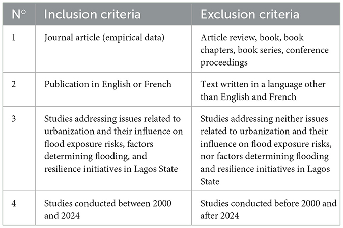
Table 1. Inclusion and exclusion criteria considered in this review.
This method made it possible to collect reliable and varied information on the factors responsible for flooding, the management measures adopted, as well as their consequences. The examination of these sources also made it possible to fill the gaps in the primary data and to consolidate the empirical basis of the study. Table 2 presents a summary of the indicators on which data are collected as well as their source.
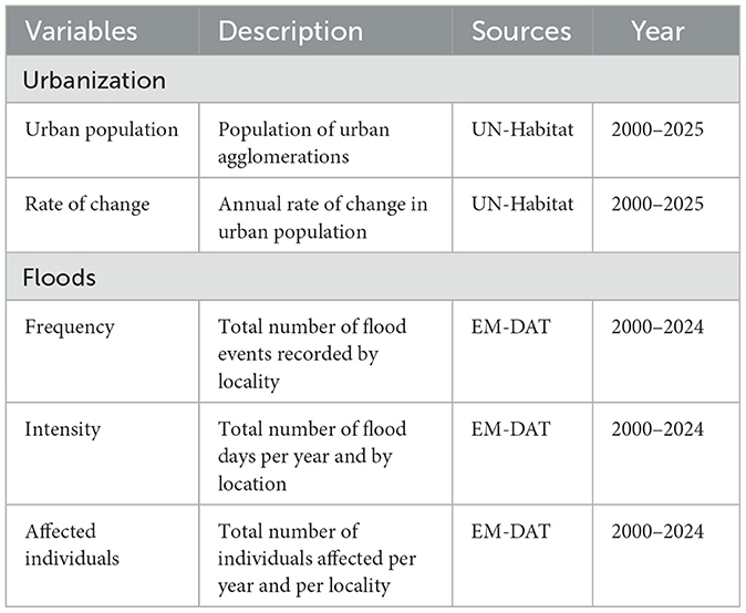
Table 2. Key indicators of poverty and climate change exploited.
3.3 Method of analysis
The chronological evolution of the parameters was assessed using time series (using the ARIMA approach), statistical analysis tools that follow the trajectory of variables over time, providing better understanding of the trends of the variables (Sakli et al., 2015). This approach is often used in studies mainly addressing flood issues (Hakim et al., 2024; Skakun et al., 2014). The high exposure of the states and localities of Nigeria was assessed through a spatial analysis using data collected on the EM-DAT platform. This spatial analysis focused on mapping to assess spatial variability as several other authors have done in similar contexts (Emmanuel Udo et al., 2015; Nkeki et al., 2013; Oluwasegun, 2017). This made it possible to highlight regional disparities in terms of exposure and intensity, based on informative visual representations.
Regarding the data collected through the literature, thematic content analysis is used to explore the factors determining the occurrence of floods, their impacts on different levels (socioeconomic, environmental, health, structural) from word clouds. The analyses were carried out using the python language version 3.9 (using packages such as pandas, matplotlib.pyplot, numpy, statsmodels.api) and the R software version 4.3.0 (using several packages such as wordcloud2, tm, RColorBrewer).
Figure 1 summarizes the analytical framework adopted in the context of this study. Indeed, the study starts from the analysis of urbanization trends within the Nigerian population and Lagos in particular. After assessing the spatial variability of flooding in this Nigerian state and exploring the impacts of this disruption, the study draws on the literature to identify all the factors (environmental, socioeconomic, institutional, structural) determining the risk of exposure to floods as a whole. Following these analyses, the study presents the main resilience initiatives, from a technical point of view (robustness, redundancy, ingenuity and speed) implemented in this state in particular to respond to disruptions. This takes as a case study, the LASEMA initiative. The overall analysis of the information received thus makes it possible to formulate relevant suggestions at the end.
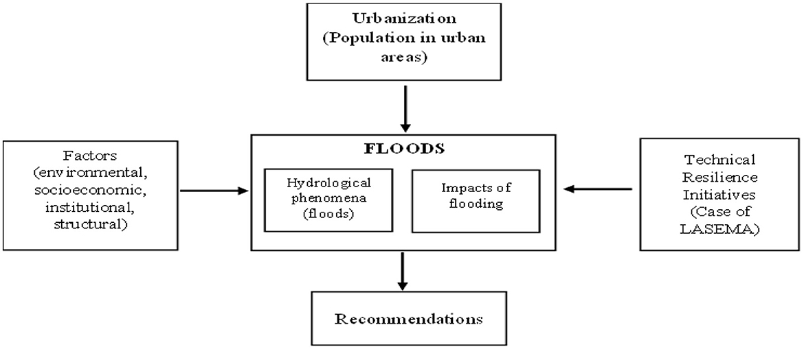
Figure 1. Analytical framework of the study.
4 Results
4.1 Dynamics of urbanization and hydrological phenomena
4.1.1 Population dynamics in urban agglomerations
Nigeria, as a nation, has been showing rapid growth in the average urban population over the past few decades. Between 1995 and 2000, the average urban population was about 575,651, and this value has almost tripled in 2020–2025 to reach 1,391,316 (Figure 2). This sustained increase underscores the acceleration of urbanization, driven by factors such as rural-urban migration, natural population growth, and the progressive development of urban centers.
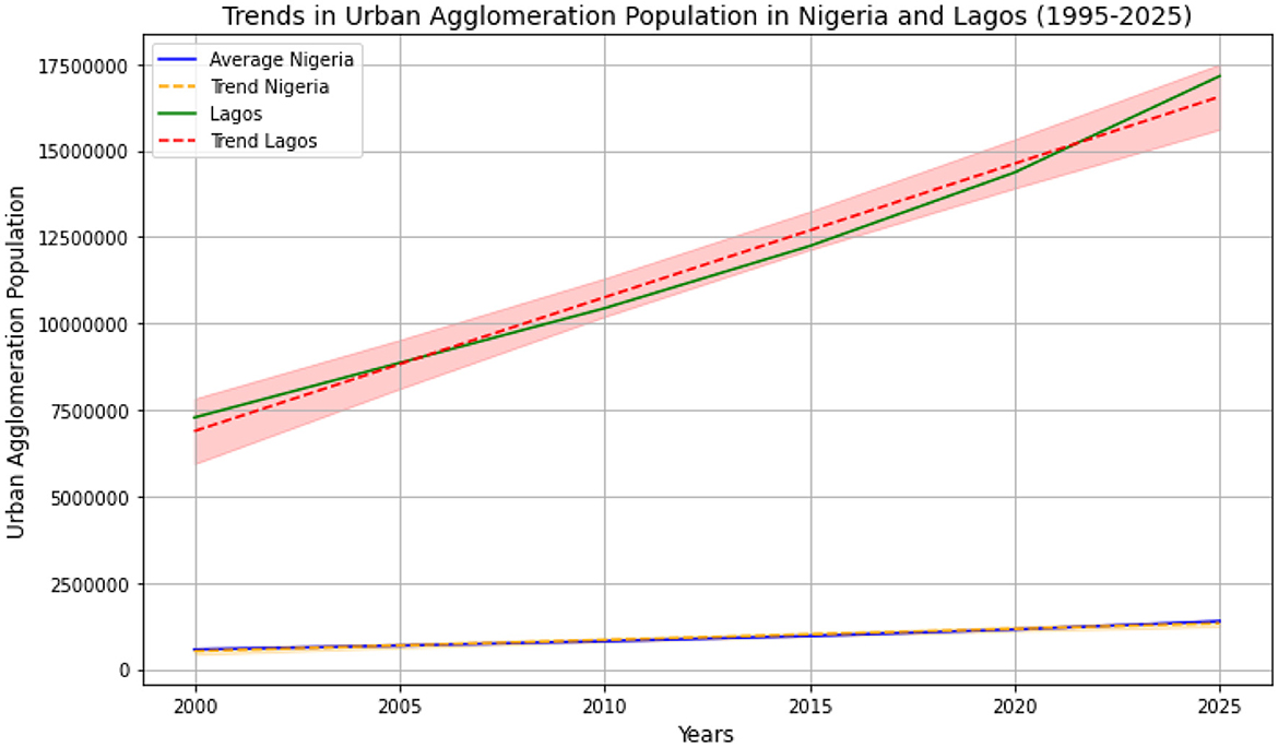
Figure 2. Population growth in urban areas in Nigeria and Lagos.
Furthermore, the analysis of the figure shows that Lagos, as the main urban engine of Nigeria, is distinguished by an explosion of its urban population, far surpassing the national average (Figure 2). In 1995–2000, Lagos already had about 7.28 million inhabitants, a figure that reached 17.15 million inhabitants in 2020–2025. This rate of growth of the urban population of Lagos, almost 2.4 times faster than the national average, reflects the central role of the city in the Nigerian and West African economy.
4.1.2 Annual rate of change in the population of urban agglomerations
At the national level, the average annual rate of change of the urban population in Nigeria shows a slight downward trend between 1995–2000 and 2010–2015, from 4.10% (1995–2000) to 3.74% (2010–2015; Figure 3). This gradual decrease reflects continued sustained urban growth but at a slightly reduced pace. However, a recovery in population dynamics is observed in the recent period, reaching 3.84% over the period 2020–2025. This oscillation indicates an imbalance between urban expansion and internal migration, as well as the challenges associated with rapid urbanization.
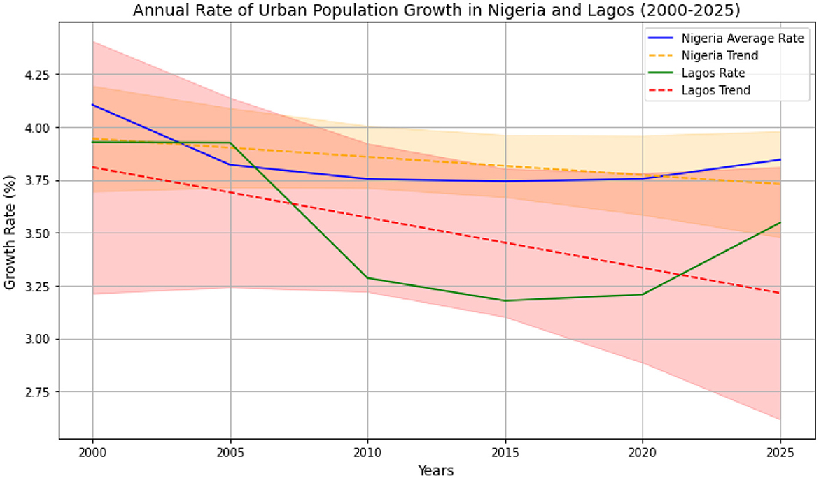
Figure 3. Annual rate of change of urban population in Nigeria and Lagos (2000–2025).
In Lagos, the annual rate of change of the urban population is generally lower than the national average over almost all periods, highlighting a more specific dynamic. Over the period 1995–2005, the rate remains stable at around 3.92%, but a sharp decline is observed thereafter, with a significant low of 3.18% between 2010 and 2015. However, Lagos also shows a slight recovery with growth reaching 3.54% between 2020 and 2025. Comparing the national situation with the case of Lagos reveals notable disparities in the pace of urbanization. While Nigeria maintains a more linear trend, Lagos appears to experience a more marked slowdown at certain periods.
4.2 Mapping of flood-prone areas in Nigeria/Lagos
4.2.1 Spatial analysis of flood frequencies in Nigeria and Lagos State
Spatial analysis of flood frequencies in Nigeria reveals a marked variation among states over the period 2000–2024 (Figure 4). Indeed, according to the cases reported in the EM-DAT database, Lagos stands out as the state with the highest number of floods, with 35 events recorded, followed by Jigawa (22) and Oyo (15). Conversely, several states, including Bayelsa, Ekiti, Ogun, Osun, and Rivers, each recorded only one flood during this period, according to the EM-DAT database. This disparity reflects specific exposure levels that could be influenced by several factors such as rapid urbanization and proximity to coastal or riverine areas. For example, Lagos' high exposure, as an economic center and a densely populated coastal city, confirms the effect of these factors especially regarding urban pressure. Conversely, these results suggest that states like Bayelsa or Ekiti could reflect lower climate risk or more diffuse land use.
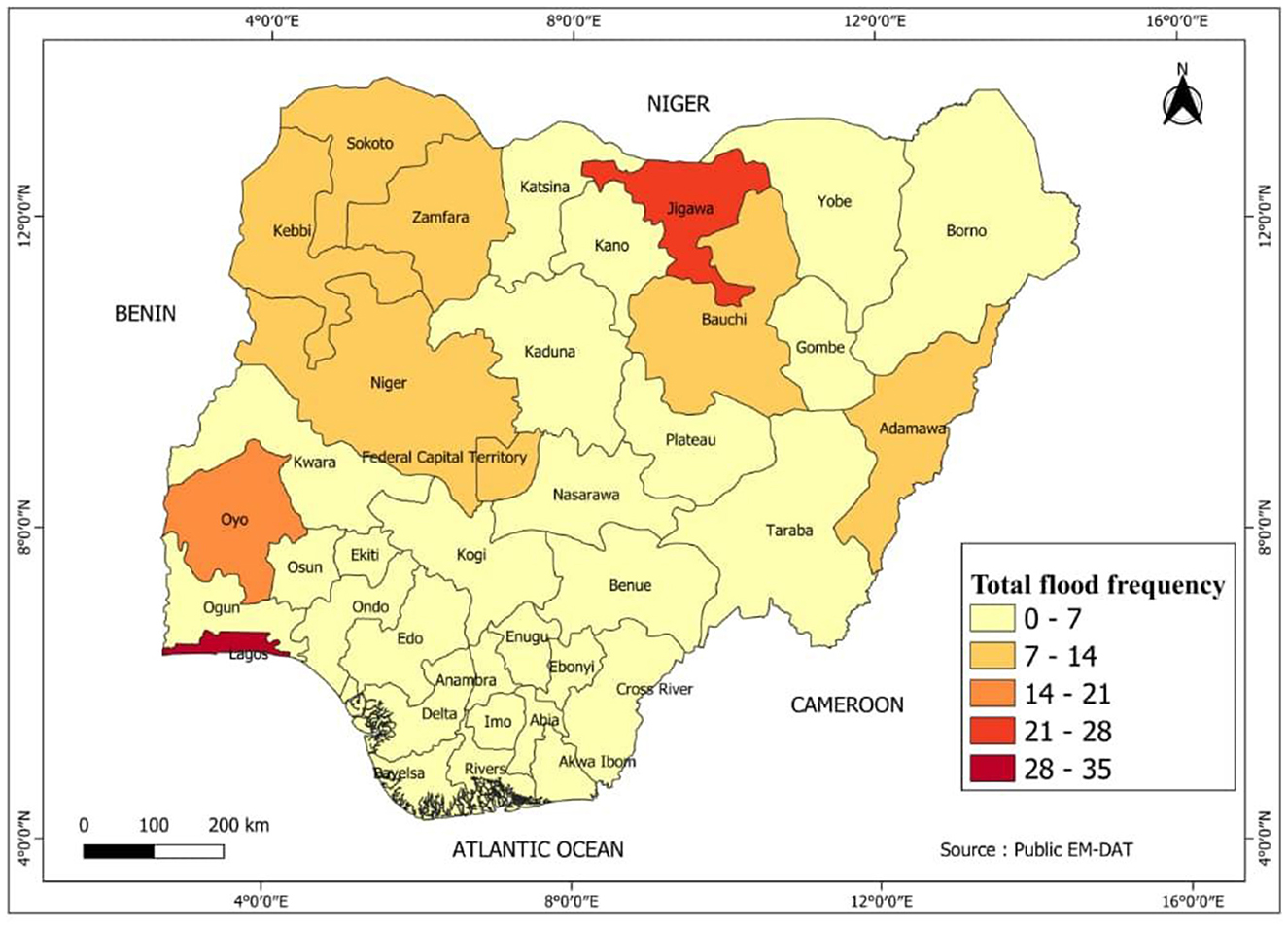
Figure 4. Spatial analysis of total flood frequency in different states of Nigeria.
4.2.2 Spatial analysis of the average duration (in days) of floods
The analysis of the average duration (average number of days) of floods per year in the different states of Nigeria (Figure 5), highlights the significant disparities in the intensity of these events in the country. Indeed, according to the EM-DAT database, Jigawa stands out as the most vulnerable state, with an annual average of 13.76 days of flooding, followed by Adamawa (6.4 days) and Niger (6.28 days), illustrating their prolonged exposure to hydrometeorological events. With regard to Lagos State, it emerges that on average, per year, this region experiences about 3 days of flooding. This highlights the fact that floods in Lagos, although highly frequent (35 events) recorded, are generally of short duration, probably due to the urban nature of this state, characterized by the rapid drainage of rainfall episodes through stormwater management infrastructures. Therefore, for the most exposed areas like Jigawa and Adamawa, targeted planning and robust flood management measures are essential.
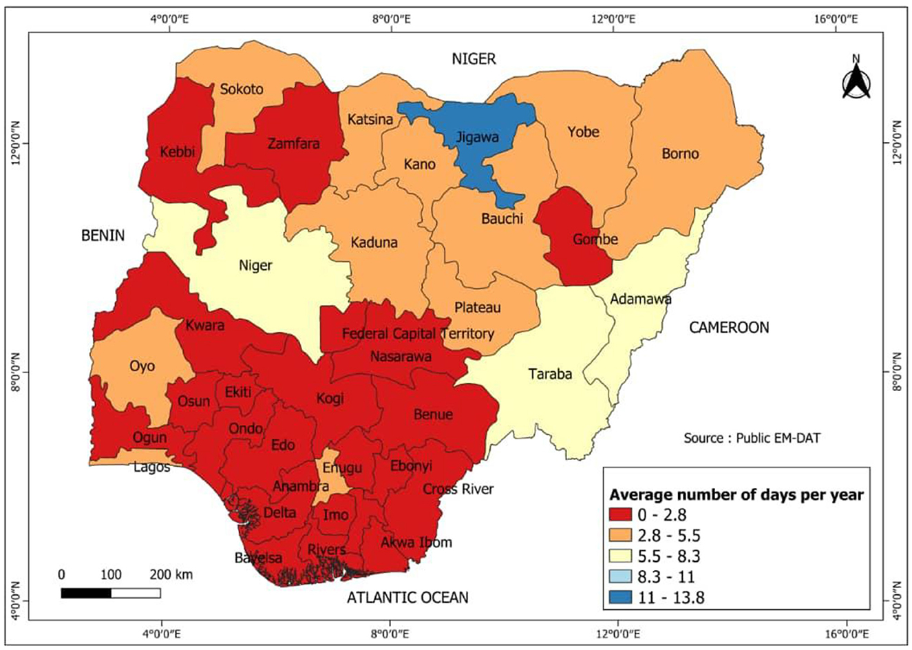
Figure 5. Spatial analysis of average annual flood duration by state in Nigeria.
In contrast, according to the EM-DAT database, some states such as Bayelsa, Ekiti, and Osun record almost negligible flood occurrence, with an annual average of < 0.1 days, suggesting lower exposure.
4.2.3 Spatial analysis of damage (affected individuals)
Figure 6 presents a spatial analysis of flood damage, highlighting the average number of individuals affected per year in each state of Nigeria over the past 25 years. Indeed, EM-DAT data reveals a notable disparity in the average number of individuals affected per year. Plateau stands out as the most severely affected state, with an annual average of 682,189.36 individuals affected, followed by Kaduna (578,486.16 individuals) and Niger (548,853.24 individuals). These figures contrast with the duration and frequency of flood events, where it can be seen that these are not the states with the most flood events nor the longest average duration (days/year). This observation suggests that although flood events are less frequent or shorter in an area, their impact on the population is particularly severe, and could be linked to the exposure of infrastructure.
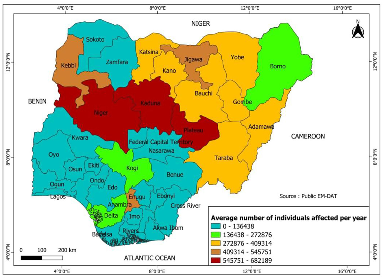
Figure 6. Spatial analysis of human damage caused by floods in Nigeria.
This can be confirmed through the case of Lagos, where although it records a high frequency of flooding over the period and a moderate average duration of 3 days per year, this region experiences relatively low figures in terms of individuals affected (2,696 people on average per year). This suggests a better resilience capacity especially through prevention efforts and or more effective management, marked by more developed adaptation strategies in this State in the face of these disasters. In contrast, States such as Bayelsa, Ekiti, Osun, and Ogun record the lowest human impacts, according to the EM-DAT database with respective averages of 20 to 200 individuals affected, probably due to less exposure to risks as evidenced by the previous results.
4.2.4 Identification of the most exposed localities in Lagos State
Particular attention was paid to Lagos State, identified through Figure 4 as the most vulnerable state to floods at the national level. This focus on the case of Lagos also allowed for a detailed analysis of the most affected localities over the last 25 years and a better understanding of intra-state disparities in exposure to floods. Indeed, the analysis of flood frequencies in the Local Government Areas (LGAs) of Lagos State reveals significant variability between localities (Figure 7). The locality of Lekki precisely the Victoria Island area stands out as the most exposed locality with a total of 7 floods recorded during this period, followed by the districts of Kosofe, Ikeja, and Agege (3 each). On the other hand, several LGAS, such as Eti-Osa, Alimosho, Ikorodu, Mainland, Oshodi and Badagry, recorded lower frequencies, with only one flood over the period studied. Meanwhile, other localities (Epe, Amuwo-Odofin), did not experience flooding according to EM-DAT data. These observations highlight the increased concentration of events in coastal areas and densely populated urban areas, such as Victoria Island in Lekki locality, probably due to their topography, proximity to water bodies and intensity of urbanization.
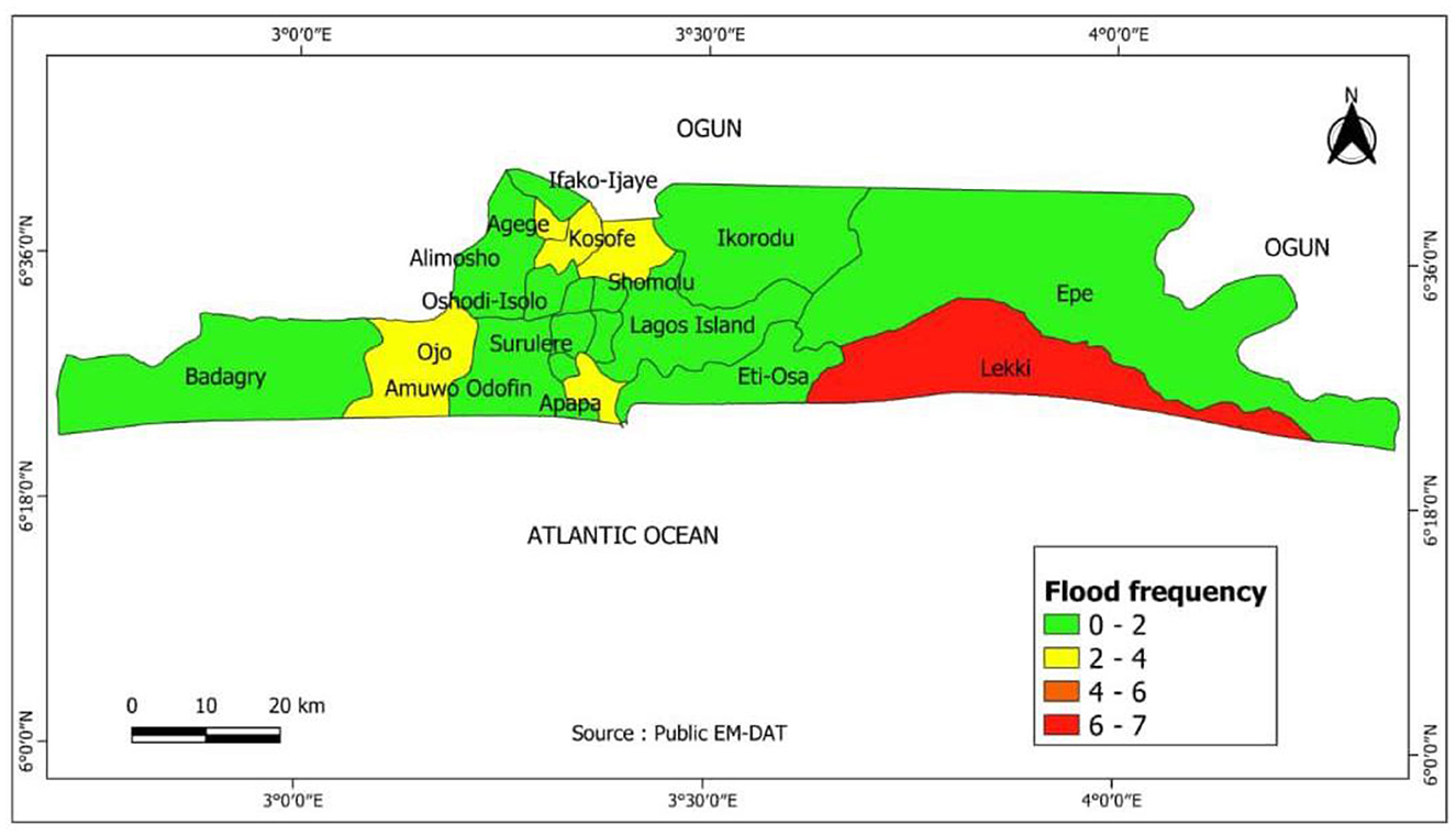
Figure 7. Spatial analysis of flood frequencies by locality in Lagos State.
4.3 Factors contributing to floods in Nigeria
4.3.1 Environmental and climatic factors
Qualitative analysis of the literature through the word cloud (Figure 8a) shows that rainfall is the key factor most identified as a major cause of flooding in Nigeria. Indeed, according to most studies carried out in this region of West Africa, rainfall dynamics play a major role in the occurrence of floods by intensifying surface flows and river overflows (Olajuyigbe et al., 2012). Thus, excessive and prolonged rainfall, mentioned by Nnodim and Ezekiel (2020) and Rufa'i (2020), increases the risk of flooding, particularly in areas where drainage infrastructure is insufficient (Evans et al., 2017). Yoade et al. (2020) and Abolade et al. (2013) also confirm that rainfall is the major cause of flooding, adding large amounts of water to surface runoff, an observation corroborated by Ekpoh (2015). Other research (Agbonkhese et al., 2014; Magami et al., 2014) highlights that phenomena such as heavy and repeated rainfall increase the risks of soil saturation and river overflows while others identify them as the major cause of flooding especially in Lagos (Evans et al., 2017; Olajuyigbe et al., 2012).
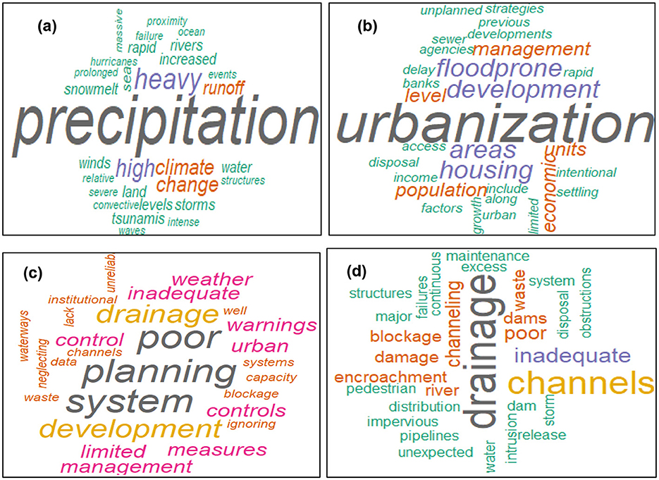
Figure 8. Major factors contributing to floods in Nigeria. (A) Environmental and climatic factors contributing to flooding in Nigeria. (B) Socioeconomic factors contributing to flooding in Nigeria. (C) Institutional factors contributing to flooding in Nigeria. (D) Infrastructure factors contributing to flooding in Nigeria.
Furthermore, climate variations are also cited as the main source of flooding in Nigeria, firstly through increased rainfall (Komolafe et al., 2015; Nkwunonwo et al., 2015), changes in hydrological regimes, or even from a considerable increase in temperature (Magami et al., 2014). Others highlight extreme events such as tidal waves, storms and strong winds as other adverse conditions, which first increase flood risks and complicate resilience strategies in more exposed localities (Magami et al., 2014; Nnodim and Ezekiel, 2020; Yoade et al., 2020). The lack of natural drainage channels that can facilitate runoff and easy absorption of excess water further amplifies the effects of these extreme events (Magami et al., 2014). This clearly shows the fundamental challenges attributed to a constantly dynamic climate suggesting the need for the implementation and adoption of appropriate strategies to minimize their impacts on vulnerable communities.
4.3.2 Socioeconomic factors
On the socio-economic level, examination of Figure 8b highlights that urbanization, particularly uncontrolled urbanization, is the main factor mentioned as significantly increasing flood risks in Nigeria. Indeed, the construction of housing and the development of other infrastructure in flood-prone areas or along waterways, without respecting urban planning standards, directly contribute to flooding. This reality is highlighted by some authors such as Adegboyega et al. (2018) and Emeribeole (2015), who highlight the increase in the number of housing units in these sensitive areas.
However, for others, urbanization phenomena associated with inappropriate management of drainage channels and waste remain the predominant human factor favoring flooding in this state (Magami et al., 2014; Njoku et al., 2020). Added to this are other factors such as the low level of development, characterized mainly by economic resources, highlighted by several studies (Hansson et al., 2008; Magami et al., 2014; Nkwunonwo et al., 2015) as other factors increasing the exposure of communities. For these authors, this is a factor that considerably limits the community's accessibility to appropriate resilience methods or strategies. It is in this sense that Ojikpong et al. (2016) emphasize the importance of income, access to formal education and information, in the adaptation of communities to floods.
In addition to these factors, Komolafe et al. (2015) and Okeleye et al. (2016), emphasize the low level of support from external actors or organizations including inadequate management of adaptation strategies, as other factors that most expose communities to flooding. Still as other catalysts, the study highlights the issue of deforestation considered as an element limiting the power of nature in absorbing rainwater Njoku et al., (2020). Okunola and Olawuni (2022) also provided a summary of the most important factors influencing household flood resilience strategies. They also highlighted high levels of financial constraints, inaccessibility to many sources of income, services, infrastructure, and lack of government support as the main factors. So many socio-economic factors highlight the need for more effective and more adapted urban planning, integrating environmental education and the economic dimension to improve the capacity to adapt to flood risks.
4.3.3 Institutional factors
In this category, the study observes that poor urban planning is the most cited factor as a source of flood amplification in Nigeria (Figure 8c). Komolafe et al. (2015) and Nkwunonwo et al. (2015) point out that recurrent floods in various parts of the country are largely the result of lack of adequate urban planning. Udoh (2015) and Ojikpong et al. (2016) reinforce this conclusion by attributing a significant portion of flood risks to poor enforcement of urban development controls. Haphazard urbanization, without consideration of environmental risks and planning standards, multiplies exposed areas, thereby aggravating the situation.
Furthermore, institutional inability to effectively manage drainage infrastructure amplifies flood risks. Indeed, the limited capacity of drainage systems, reported by several authors (Aderogba, 2012; Okeleye et al., 2016; Olajuyigbe et al., 2012), leads to the obstruction of natural and artificial water evacuation routes. Blockages of drainage channels, often caused by poor waste management as reported by Ojikpong et al. (2016), limit effective runoff, especially in urban areas such as Lagos. Hansson et al. (2008) also note the inadequacy of drainage systems as a broader symptom of the structural weakness of public institutions in preventing natural disasters.
Another key institutional factor is the neglect of data and warnings from hydrological warning systems. Magami et al. (2014) report that warnings from the Nigerian Meteorological and Hydrological Agency are often ignored, compromising the anticipation and response capacities of communities. Hansson et al. (2008) describe the institutional system as inadequate and unreliable in disaster prevention and mitigation. The lack of flood control measures (Magami et al., 2014) and the absence of proactive governance the overall flood risk level, requiring urgent reform of institutional approaches in the country.
4.3.4 Infrastructure factors
Word cloud analysis (Figure 8d) shows that failures of dams and water systems are among the major factors aggravating floods in Nigeria. For example, Magami et al. (2014) point out that dam failures and uncontrolled release of excess water from artificial reservoirs lead to flash floods, particularly in riverine areas. Yoade et al. (2020) corroborate these observations by mentioning damage to dams and inadequate management of reservoirs, which significantly increase flood risks in affected areas. Such gaps in maintenance and monitoring of water infrastructure exacerbate the effects of coastal storms and flash floods.
Other structural factors highlighted in the literature are the absence and poor management of suitable drainage channels for better management of runoff water. This is considered another cause amplifying flooding in urban areas, particularly through waste disposal problems and overloading of these drainage channels (Emeribeole, 2015; Magami et al., 2014; Ojikpong et al., 2016; Olajuyigbe et al., 2012; Yoade et al., 2020). Evans et al. (2017) and Nwigwe and Embargo (2014) add to these factors the issue of increasing illegal construction, as a cause preventing the flow of water, thus increasing the frequency and intensity of floods.
Finally, the expansion of impermeable surfaces associated with the insertion of dwellings in stormwater areas are highlighted by Yoade et al. (2020) as other factors disrupting the natural water cycle and which at the same time increase flood risks. These observations highlight the main infrastructure challenges in flood prevention in Nigeria and especially in Lagos.
4.4 Impacts of floods in Nigeria
The qualitative analysis of the literature review shows that floods cause several significant environmental impacts (Figure 9a). Studies have particularly focused on the alteration of agricultural land, reducing the fertility and exposure of arable land (Eze et al., 2018; Umar and Gray, 2023). Then, as major environmental impacts, these disasters increase the pollution of rivers and streams, leading to significant losses of aquatic biodiversity (Nnodim and Ezekiel, 2020). The distortion of the natural balance of these ecosystems is also accentuated by the death of animals and the introduction of invasive insects in flooded areas (Sale, 2014). Soil erosion and gully formation, as indicated by Oruonye et al. (2017), is another major impact of flooding, also contributing to the loss of agricultural land and increasing the degree of soils. The submersion of wells and pollution of rivers limit access to drinking water, thus aggravating health challenges within local communities (Oyekale, 2013).
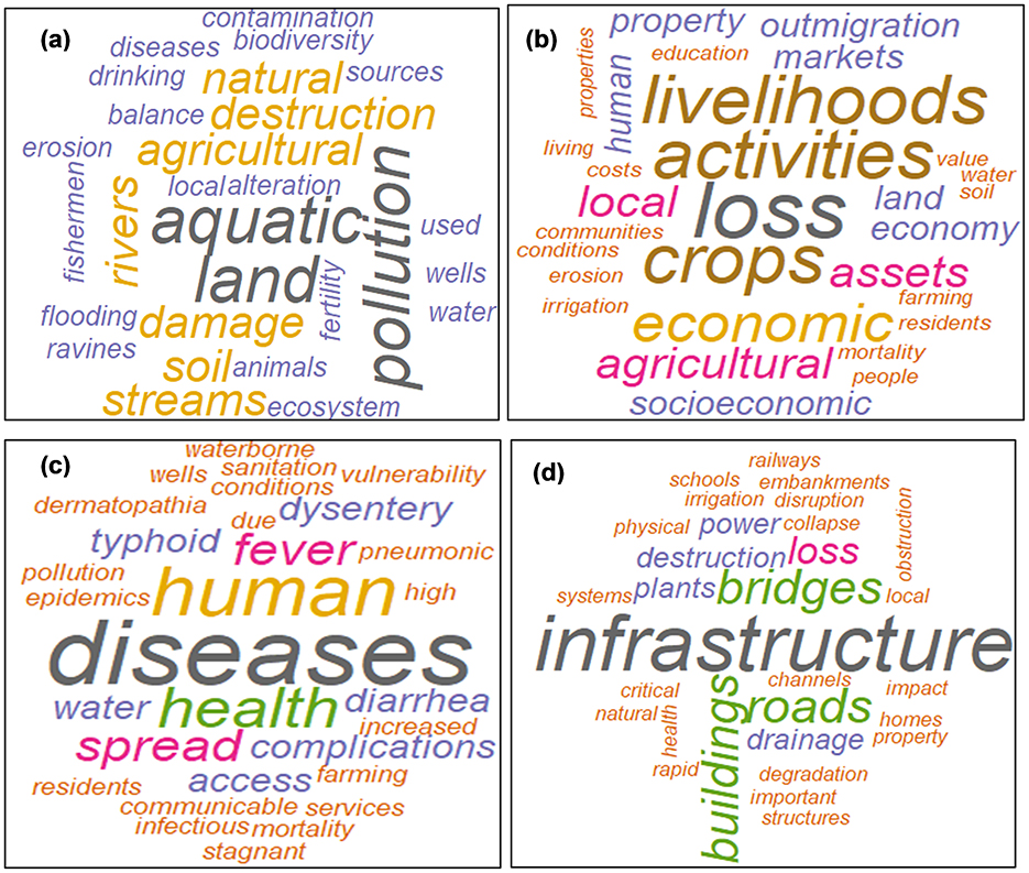
Figure 9. Environmental, socio-economic, health and structural impacts of floods in Nigeria. (A) Environmental impacts of flooding. (B) Economic impacts of flooding. (C) Health impacts of flooding. (D) Structural impacts of flooding.
Among the economic consequences, the study observes a predominance of disruptions to economic activities and livelihoods of local populations, as major impacts of floods raised by the literature. This is considerably accentuated by the loss of agricultural and financial harvests (Ajayi et al., 2012; Ani et al., 2020). Indeed, these disasters are located as sources of major destruction of important infrastructures including roads, bridges, irrigation systems, local markets, making difficult not only agricultural production but also their marketing (Nnodim and Ezekiel, 2020; Ojikpong et al., 2016; Oyekale, 2013; Umar and Gray, 2023). These impacts thus compromise the economic stability of households and accentuate poverty and inequalities within the community (Ojikpong et al., 2016; Oruonye et al., 2017). Added to these impacts are the human consequences marked by loss of human lives associated with mass displacement of communities, generating major expenditures for the government and social tensions (Onifade et al., 2023; Ikusemoran et al., 2013). This is the case of Lagos State which experienced several losses of human lives in 2011 and 2012 due to flood disasters (Onifade et al., 2023). These impacts thus increase the pressure on public goods and especially on resources, including housing, drinking water and medical services, complicating the management of disaster-stricken populations (Wizor, 2014).
The word cloud results highlight the extent of health impacts caused by flooding in Nigeria (Figure 9c). This qualitative analysis reveals that flooding has significant health impacts, particularly the spread of infectious diseases due to the unsanitary conditions it creates (Onifade et al., 2023). In parallel, pollution of wells and drinking water sources caused by flooding promotes the transmission of waterborne diseases such as cholera, typhoid fever and dysentery including dermatopathies and respiratory infections (Dalil et al., 2015; Oyekale, 2013; Sale, 2014). These health impacts contribute to a vicious cycle where public health is compromised in the long term, increasing social and health risks for residents of flood-affected areas.
Structurally, word cloud analysis from previous studies reveals that floods cause significant damage to infrastructure, affecting elements essential to the functioning of modern societies (Figure 9d). Among the most affected infrastructures, particular emphasis is placed on roads, bridges, buildings, power plants and irrigation infrastructure, often suffering irreversible damage due to fast currents and water pressure (Ani et al., 2020; Bariweni et al., 2012). For example, in 2012, many roads and railways were devastated following floods recorded in some regions of the country, severely limiting travel and the transport of goods (Ikusemoran et al., 2013; Olatunji and Yoade, 2022). In addition, critical social infrastructure, including schools, hospitals, and health facilities, suffer significant damage during floods, exacerbating social and economic crises (Egbinola et al., 2017). These disasters also disrupt electricity and water supply systems, further complicating the recovery of activities in affected areas (Ajayi et al., 2012). Thus, the disruption of these services increases economic instability and further limits the resilience of affected populations.
4.5 Key resilience initiatives in Lagos/Nigeria
Several strategies have been undertaken in Lagos State to strengthen the resilience of communities in the state to floods. This is the case, for example, of the establishment of the Lagos State Emergency Management Agency (LASEMA), cited as one of the major actions developed in this region for disaster management (Ndimele et al., 2024). In addition, there are other strategies such as the construction of infrastructure such as rainwater drainage systems and the construction of the “Great Wall of Lagos” to minimize flood risks (Ndimele et al., 2024).
4.5.1 Case of Lagos State Emergency Management Agency (LASEMA)
LASEMA was established in 2008 under the Ministry of Special Duties and Intergovernmental Relations to ensure prevention, preparedness and management of floods and other disasters such as fires and building collapses (Ndimele et al., 2024; Olokesusi and Aiyegbajeje, 2019). The agency coordinates the interventions of stakeholders, including ambulance services, ferry transport and traffic management, in collaboration with the National Emergency Management Agency (NEMA), to ensure effective response to emergencies (Olokesusi and Aiyegbajeje, 2019). Furthermore, the efficiency of this agency is enhanced by relying on the use of modern and advanced technologies, including more than 13,000 CCTV cameras, strategic dispatch centers, a GPS system, early warning systems in vulnerable areas, toll-free telephone lines, thus making these interventions easy (Olokesusi and Aiyegbajeje, 2019). Added to this are awareness campaigns based on traditional methods to ensure disaster prevention by involving the populations (Olokesusi and Aiyegbajeje, 2019). The good performance of this agency has been recognized by Adefisoye (2015) and is mainly based on its well-organized structure and the quality of its interventions and services (rescue operations, evacuations, temporary relocation of affected individuals to the Lagos State relief center; Yusuf, 2022).
However, despite this effectiveness, this agency is identified by some (Abdussalaam et al., 2024; Adelekan, 2016) as still not very accessible, reporting that only 0.3% of the individuals met during their studies have benefited at least once from the assistance of this organization. This highlights the need for better visibility and accessibility of the actions of this agency. Nevertheless, it is important to specify that this limited recognition of LASEMA could be due to the mistrust of the population, especially by referring to the findings of Yusuf (2022) who specifies that some disaster victims generally avoid resettlement in emergency housing for fear of the unknown. This reluctance, confirmed by a LASEMA official, often leads these individuals to become internally displaced, settling in communities close to flooded areas (Yusuf, 2022). This observation highlights a major challenge for this agency, which must strengthen the level of trust and the acceptability of its temporary solutions. All of these observations are summarized in Figures 9, 10.
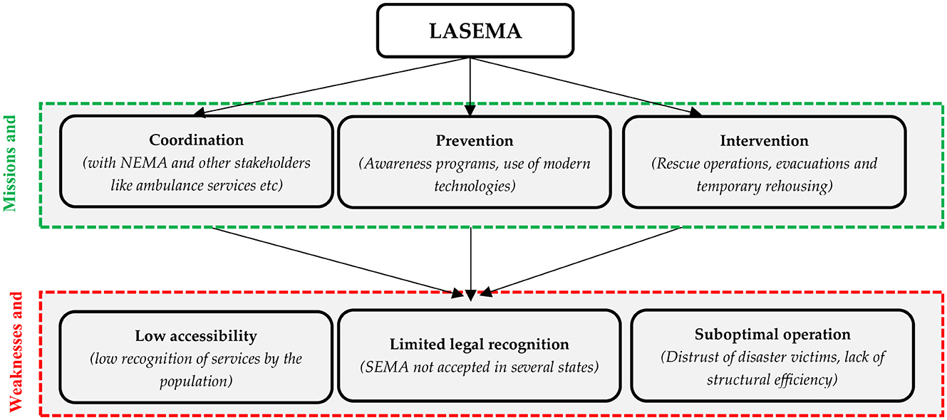
Figure 10. Organizational analysis and limitations of LASEMA. Source: synthesis from documentary analyses.
4.5.2 Case studies of some local infrastructures
According to Adelekan (2016), flood risk management in Lagos has traditionally relied on structural measures, mainly focusing on the construction and maintenance of drainage channels. These initiatives began in 1974 with the development of the first drainage master plan for Lagos Mainland, followed by two more plans in 1992 and 1998 covering other areas of the city (Adelekan, 2016). On the one hand, a major initiative is the construction of the “Great Wall of Lagos,” a 7 km barrier designed to protect the city from coastal flooding and storm surges, incorporating 100,000 concrete blocks specially designed to dissipate the force of waves (Adelekan, 2016; Ndimele et al., 2024).
On the other hand, there is increasing attention on infrastructures such as sustainable urban drainage systems (SUDS) that efficiently manage stormwater (Danladi et al., 2024). Added to this are other proposals such as river maintenance, the installation of breakwaters along the coasts and the demolition of buildings in risky areas (Adelekan, 2016). However, these proposals especially maintenance are disrupted by the issue of inefficient waste management, which damages drainage channels (Nkwunonwo et al., 2016).
To address these shortcomings, the Lagos government has implemented non-structural measures. These include zoning and land use regulations to limit urbanization in exposed areas, with specific provisions for minimum setbacks from water bodies and drainage areas (Adelekan, 2016). However, enforcement of these regulations remains ineffective, as illustrated by the persistent presence of buildings on floodplains. Initiatives such as granting land at lower cost to developers are aimed at discouraging construction in risky areas. Furthermore, some high-risk areas, such as Isheri North, have had their initial development approvals withdrawn (Adelekan, 2013).
Other non-structural strategies focusing on risk analysis and reduction have only recently been adopted, gradually integrating policies and frameworks to raise awareness and encourage collaborative participation in flood management (Bubeck et al., 2017; Rubinato et al., 2019). However, these measures remain limited in ensuring the protection of exposed populations, particularly the urban poor, who suffer the most severe consequences (Adelekan, 2016). Table 3 summarizes the main structural and non-structural measures summarized above.
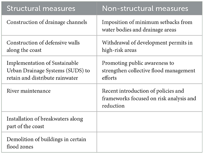
Table 3. Summary of structural and non-structural measures.
4.6 Proposed recommendations
To enhance the effectiveness and impact of initiatives implemented in Lagos such as LASEMA, some recommendations are necessary. First, it is essential to develop a dynamic communication approach to strengthen awareness and ease of access to the agency's actions. This can be done by implementing tailored awareness campaigns, establishing collaboration with local communities and using interactive digital platforms to disseminate information on the services offered and access conditions. This is in parallel with the proposals of Danladi et al. (2024) who suggest raising awareness and actively involving citizens to strengthen resilience to disasters, given the limitations of current policies.
Second, flood management efforts in Lagos require better integration of early warning systems, such as sensors, water gauges, and satellite data, to provide timely and accurate information on impending risks (Adelekan, 2016). Although public and private sector initiatives are already in place to manage these disasters, there is still an urgent need to fill gaps, including by adapting strategies to the specific needs of a rapidly changing climate.
Finally, to address the population's distrust of resettlement centers, LASEMA could establish participatory mechanisms involving local communities in the planning and management of temporary reception solutions, combining regular consultations and adaptation measures to the specific needs of disaster victims. These initiatives would help to strengthen the trust and commitment of residents while optimizing the effectiveness of the solutions proposed.
5 Discussion
The rapid growth of the urban population, both nationally and in Lagos, illustrates the increasing pressures on urban infrastructure and the environment, thereby increasing exposure to natural hazards such as floods (Adegboyega et al., 2018; Unegbua et al., 2024). While the national average shows sustained but more moderate urbanization, there is a strong dynamic of the urban population in Lagos State, which is about 3 times faster than the national average. This growth of the urban population in Lagos has also been highlighted by Gilbert and Shi (2024). However, this rapid urbanization, coupled with an oscillating annual rate of change, reflects the structural challenges facing Lagos, including the saturation of drainage systems and unplanned urbanization, thus exposing the state to a high risk of flooding (Aderogba, 2012; Auwalu and Bello, 2023). This was also confirmed through the spatial analysis of flood frequencies in the different states, where it appears that Lagos State records an extremely high frequency of flood events (35 floods in 25 years). The relevance of these results corroborates the ranking of the population of Lagos State as the 15th most exposed to floods in the world based on the projections of the 2,070 climate scenario (Adegun, 2023). This recurrence, unique to Nigeria, highlights the structural challenges facing Lagos as a densely populated coastal city and the economic engine of the country (Amaeze and Otabor, 2024; Nkwunonwo et al., 2016; Olajuyigbe et al., 2012). Rapid urbanization, combined with soil sealing and proximity to the lagoon and the Atlantic Ocean, constitutes a key factor in this exposure (Ndimele et al., 2024).
The spatial analysis at the local scale of Lagos State showed that the locality of Lekki in particular in Victoria Island is the most exposed to flooding in this state. This partially echoes the results of Ndimele et al. (2024) who rather highlighted the exposure of localities on Lagos Island, closely followed by Victoria Island, which was hit by floods about three times in one year (year 2000). This partial difference characterized by the positioning of Lagos Island as the locality having experienced the greatest intensity and severity of floods in Lagos State, could be linked to the fact that the work of Ndimele et al. (2024) covered the data over a wider period from 1968 to 2020.
However, this high frequency of floods in Lagos State is coupled with a low average duration (about 3 days per year) and a reduced number of people affected compared to other states. This reflects significant adaptation efforts, particularly through the establishment of a number of management agencies and the improvement of urban drainage systems and climate resilience policies. For example, LASEMA is identified as the most effective state emergency management agency (Adefisoye, 2015). However, unlike Lagos, This agency has not yet reached optimal functioning in some States or is still unrecognized in several other States (Edo, Cross Rivers, Rivers, Kano, etc.; Adefisoye, 2015). These dynamics suggest that proactive management can limit the impacts of these recurring disasters but also raise the question of the sustainability of these efforts in the face of increasing pressures such as climate change and population expansion.
However, apart from urbanization, the results highlight a complexity of interrelated factors responsible for floods in Nigeria, including environmental, socioeconomic, institutional and infrastructural. First, climate change, characterized by abundant rainfall, through its amplifying role on the frequency and intensity of floods, emerges as main triggers (Nnodim and Ezekiel, 2020; Rufa'i, 2020), factors confirmed in other geographical contexts such as China (Islam and Wang, 2024), Pakistan (Otto et al., 2023); Japan (Faiz et al., 2024). Other factors have been highlighted, particularly institutional factors (poor urban planning, inappropriate management of infrastructure such as dams and drainage channels; Komolafe et al., 2015; Nkwunonwo et al., 2015; Ojikpong et al., 2016; Udoh, 2015).
In terms of impacts, on the environmental level, the study highlights the emphasis on the degradation of agricultural land, the destruction of aquatic environments, soil erosion and many other consequences, strongly demonstrating the influence of floods on natural resources (Eze et al., 2018; Umar and Gray, 2023). The economic impact is marked by the reduction of income-generating activities, particularly through a reduction in exploitable land and important infrastructure (roads, markets, etc.). This highlights the need for improved infrastructure management in exposed areas (Ahmad and Afzal, 2021; Al Sharjabi et al., 2024; Rosinger et al., 2023). From a health perspective, the study highlights water stagnation and pollution issues that promote the increase in waterborne and infectious diseases, thus showing the challenges related to health infrastructure and emergency response mechanisms (Ajayi et al., 2012; Sale, 2014). Finally, the destruction of infrastructure (roads, public facilities), further demonstrates the degree of exposure linked to poor urban planning and a lack of resilience of infrastructure in the face of climate change (Bariweni et al., 2012; Ani et al., 2020).
These findings highlight the importance of a global approach combining adaptation policies, investments in climate-resistant infrastructure, and efficient governance systems for sustainable management of the impacts of these disasters.
6 Conclusion
This research highlights the fundamental challenges associated with flooding in Lagos, which are further aggravated by rapid urbanization, saturation of drainage systems and climate change. This situation is even more pronounced in Lagos State, mainly due to rapid population expansion and geographical susceptibility particularly due to its proximity to the lagoon and the Atlantic Ocean. However, the study finds that within this state, flooding events remain brief and affect only a small number of people, reflecting the relative effectiveness of adaptation measures implemented in this area. Among the most effective adaptation strategies, the study highlights the improvement of drainage systems and the establishment of emergency management agencies such as LASEMA. Although, other structural and institutional causes constitute major barriers to sustainable flood management.
In this perspective, the recommendations of this study aim to improve the effects of ongoing initiatives and address the identified shortcomings. The integration of more advanced early warning systems and the improvement of communication on LASEMA interventions should be considered as a priority. In addition, the establishment of participatory mechanisms to involve local communities in the management of resettlement centers would improve the resilience of residents while reducing their mistrust of these solutions. These proposals must be accompanied by a more proactive approach and increased attention to resilient urban infrastructure, to better anticipate and manage the future impacts of flooding in Lagos.
Furthermore, the main limitation of this research lies in the secondary data used, the EM-DAT database which, although useful for assessing general dynamics, is highly dependent on the declarations of flood cases in each region. This can lead to an underestimation of actual events, especially in areas with less institutional coverage. Therefore, regions not listed as having experienced floods in this database are not necessarily exempt from these phenomena but could simply be associated with a lack of reporting.
Data availability statement
The original contributions presented in the study are included in the article/supplementary material, further inquiries can be directed to the corresponding author.
Author contributions
KD: Conceptualization, Data curation, Formal analysis, Funding acquisition, Investigation, Methodology, Project administration, Resources, Software, Supervision, Validation, Visualization, Writing – original draft, Writing – review & editing. YM: Data curation, Formal analysis, Investigation, Methodology, Project administration, Resources, Software, Validation, Writing – original draft, Writing – review & editing. SB: Data curation, Investigation, Methodology, Resources, Supervision, Validation, Visualization, Writing – original draft, Writing – review & editing. FO: Data curation, Formal analysis, Methodology, Project administration, Resources, Supervision, Validation, Visualization, Writing – original draft, Writing – review & editing.
Funding
The author(s) declare that no financial support was received for the research and/or publication of this article.
Conflict of interest
The authors declare that the research was conducted in the absence of any commercial or financial relationships that could be construed as a potential conflict of interest.
Generative AI statement
The author(s) declare that no Gen AI was used in the creation of this manuscript.
Publisher's note
All claims expressed in this article are solely those of the authors and do not necessarily represent those of their affiliated organizations, or those of the publisher, the editors and the reviewers. Any product that may be evaluated in this article, or claim that may be made by its manufacturer, is not guaranteed or endorsed by the publisher.
References
Abdussalaam, S. A., Olatunde, K. A., Babajide, E. I., Adedeji, O. H., and Adeofun, C. O. (2024). Institutional framework for disaster risk management in Nigeria: need for a paradigm shift. J. Appl. Sci. Environ. Manage. 28, 2483–2491.
Abolade, O., Muili, A. B., and Ikotun, S. A. (2013). Impacts of flood disaster in agege local government area Lagos, Nigeria. Int. J. Dev. Sustain. 2, 2354–2367. Available online at: https://isdsnet.com/ijds-v2n4-13.pdf
Adefisoye, T. (2015). An assessment of Nigeria's institutional capacity in disaster management. Sci. Res. J. 3, 37–48. Available online at: https://www.scirj.org/jan-2015-paper.php?rp=P0115228
Adegboyega, S. A., Onuoha, O. C., Adesuji, K. A., Olajuyigbe, A. E., Olufemi, A. A., and Ibitoye, M. O. (2018). An integrated approach to modelling of flood hazards in the rapidly growing city of Osogbo, Osun State, Nigeria. Space Sci. Int. 4, 1–15. doi: 10.3844/ajssp.2018.1.15
Adegun, O. B. (2023). Climatic disasters within a flood-prone coastal slum in Lagos: coping capacities and adaptation prospects. Int. J. Disaster Resil. Built Environ. 14, 212–228. doi: 10.1108/IJDRBE-11-2021-0154
Adelekan, I. O. (2013). Private sector investment decisions in building and construction: increasing, managing and trans ferring risks: case study of Lagos, Nigeria. Background paper prepared for the Global Assessment Report on Disaster Risk Reduction 2013. Available online at: https://www.preventionweb.net/english/hyogo/gar/2013/en/bgdocs/Adelekan%2C%202012.pdf (Accessed February 9, 2025).
Adelekan, I. O. (2016). Flood risk management in the coastal city of Lagos, Nigeria. J. Flood Risk Manag. 9, 255–264. doi: 10.1111/jfr3.12179
Aderogba, K. A. (2012). Global warming and challenges of floods in Lagos metropolis, Nigeria. Acad. Res. Int. 2, 455–468. Available online at: http://savap.org.pk/journals/ARInt./Vol.2(1)/2012(2.1-46).pdf
Adogamhe, P. G. (2024). “Nigeria in the region and the world: diplomatic challenges in a multipolar world,” in Diplomatic Strategies of Rising Nations in the Global South: The Search for Leadership and Influence (Cham: Springer International Publishing), 243–272. doi: 10.1007/978-3-031-52629-9_9
Agbola, B. S., Ajayi, O., Taiwo, O. J., and Wahab, B. W. (2012). The august 2011 flood in Ibadan, Nigeria: anthropogenic causes and consequences. Int. J. Disaster Risk Sci. 3, 207–217. doi: 10.1007/s13753-012-0021-3
Agbonkhese, O., Agbonkhese, E. G., Aka, E. O., Joe-Abaya, J., Ocholi, M., and Adekunle, A. (2014). Flood menace in Nigeria: impacts, remedial and management strategies. Civ. Environ. Res. 6, 32–40. Available online at: https://www.iiste.org/Journals/index.php/CER/article/view/12140
Ahmad, D., and Afzal, M. (2021). Flood hazards, human displacement and food insecurity in rural riverine areas of Punjab, Pakistan: policy implications. Environ. Sci. Pollut. Res. 28, 10125–10139. doi: 10.1007/s11356-020-11430-7
Aiyewunmi, T. (2023). Challenges and Potential Solutions to Pluvial Flood Risk in Urban Tropical African Communities, A Case Study Using Ijebu-Ode, in South West Nigeria (Liverpool: Doctoral Dissertation, University of Liverpool).
Ajayi, O., Agboola, S. B., and Olokesusi, B. F. (2012). “Hydrology for disaster management,” in Special publication of the Nigerian Association of Hydrological Sciences. Nigerian Association of Hydrological Sciences.
Al Sharjabi, S. J., Al Jawaldeh, A., Hassan, O. E. H., and Dureab, F. (2024). Understanding the food and nutrition insecurity drivers in some emergency-affected countries in the Eastern Mediterranean Region from 2020 to 2024. Nutrients 16:3853. doi: 10.3390/nu16223853
AlRyalat, S. A., Malkawi, L. W., and Momani, S. M. (2019). Comparing bibliometric analysis using PubMed, Scopus, and Web of Science databases. J. Vis. Exp. e58494. doi: 10.3791/58494
Amaeze, J., and Otabor, R. (2024). Potentials of Coastal tourism and Hospitality in Lagos State, Nigeria: Challenges and Prospects. Lagos State University Press.
Ani, C. N., Ezeagu, C. A., Nwaiwu, N. K., and Ekenta, E. O. (2020). Analysis of factors influencing flooding and vulnerability assessment of Awka and its environs. Am. J. Eng. Res. 9, 34–45. Available online at: https://www.ajer.org/papers/Vol-9-issue-5/D09053445.pdf
Arinabo, D. (2022). Unveiling the role of contextual factors in the evolution of urban floods in Sub-Saharan Africa: lessons from Kampala city. Environ. Sci. Policy 137, 239–224. doi: 10.1016/j.envsci.2022.09.001
Arinabo, D. (2024). Understanding the Evolving Nature of Urban Flood Risks in Sub-Saharan Africa: The Case of Kampala City, Uganda. Cham: Springer Nature. doi: 10.5772/intechopen.1005760
Arouri, M. E. H., Youssef, A. B., Nguyen-Viet, C., and Soucat, A. (2014). Effects of Urbanization on Economic Growth and Human Capital Formation in Africa.
Auwalu, F. K., and Bello, M. (2023). Exploring the contemporary challenges of urbanization and the role of sustainable urban development: a study of Lagos City, Nigeria. J. Contemp. Urban Aff. 7, 175–188. doi: 10.25034/ijcua.2023.v7n1-12
Bariweni, P. A., Tawari, C. C., and Abowei, J. F. N. (2012). Some environmental effects of flooding in the Niger Delta Region of Nigeria. Int. J. Fish. Aquat. Sci. 1, 35–46. Available online at: https://maxwellsci.com/print/ijfas/v1-35-46.pdf
Berrang-Ford, L., Pearce, T., and Ford, J. D. (2015). Systematic review approaches for climate change adaptation research. Reg. Environ. Change 15, 755–769. doi: 10.1007/s10113-014-0708-7
Bruneau, M., Chang, S. E., Eguchi, R. T., Lee, G. C., O'Rourke, T. D., Reinhorn, A. M., et al. (2003). A framework to quantitatively assess and enhance the seismic resilience of communities. Earthquake Spectra 19, 733–752. doi: 10.1193/1.1623497
Bubeck, P., Kreibich, H., Penning-Rowsell, E. C., Botzen, W. J. W., De Moel, H., and Klijn, F. (2017). Explaining differences in flood management approaches in Europe and in the USA – a comparative analysis. J. Flood Risk Manag. 10, 436–445. doi: 10.1111/jfr3.12151
Dalil, M., Mohammad, N. H., Yamman, U. M., Husaini, A., and Mohammed, S. L. (2015). An assessment of flood vulnerability on physical development along drainage channels in Minna, Niger State, Nigeria. Afr. J. Environ. Sci. Technol. 9, 38–46. doi: 10.5897/AJEST2014.1815
Danladi, A. J., Yusuf, M. K., Dusserre, G., Ahmed, N. B., and Vechot, L. (2024). Pre-disaster preparedness/prevention and mitigation strategies for floods: a use case of Lagos, Nigeria. Am. J. Environ. Clim. 3, 16–27. doi: 10.54536/ajec.v3i3.3362
Drepper, B., Bamps, B., Gobin, A., and Van Orshoven, J. (2021). Strategies for managing spring frost risks in orchards: effectiveness and conditionalitya systematic review protocol. Environ. Evid. 10:32. doi: 10.1186/s13750-021-00247-7
Echendu, A. J. (2023). Human factors vs climate change; experts' view of drivers of flooding in Nigeria. Nat. Hazards Res. 3, 240–246. doi: 10.1016/j.nhres.2023.04.002
Egbinola, C. N., Olaniran, H. D., and Amanambu, A. C. (2017). Flood management in cities of developing countries: the example of Ibadan, Nigeria. J. Flood Risk Manag. 10, 546–554. doi: 10.1111/jfr3.12157
Eguaroje, O., Alaga, T., Ogbole, J., Omolere, S., Alwadood, J., Kolawole, I., et al. (2015). Flood vulnerability assessment of Ibadan city, Oyo state, Nigeria. World Environ. 5, 149–159. Available online at: http://article.sapub.org/10.5923.j.env.20150504.03.html
Ekpoh, I. J. (2015). Climate change and recent severe flooding in Uyo, Akwa Ibom State, Nigeria. Glob. J. Soc. Sci. 14, 23–23. doi: 10.4314/gjss.v14i1.3
Emeribeole, A. C. (2015). “Managing flood disasters in Nigerian cities: Issues and strategies towards meeting the challenges in the modern world (A case study of Owerri Metropolis, Imo State, Nigeria),” in From the Wisdom of the Ages to the Challenges of the Modern World: Proceedings of the International Conference, Sofia, Bulgaria, 17–21 May 2015 (Sofia: Bulgarian Academy of Sciences).
Emmanuel Udo, A., Ojinnaka, O. C., Baywood, C. N., and Gift, U. A. (2015). Flood hazard analysis and damage assessment of 2012 flood in Anambra State using GIS and remote sensing approach. Am. J. Geogr. Inf. Syst. 4, 38–51. Available online at: http://article.sapub.org/10.5923.j.ajgis.20150401.03.htm
Evans, U. F., Dominic, K. O., Evans, G. U., and Utting, C. (2017). Analysis of the relative contributions of climatic elements and environmental variables to flood disaster in Uyo, AkwaIbom State, Nigeria. Int. J. Environ. Sci. Nat. Resour. 6, 52–56. Available online at: https://juniperpublishers.com/ijesnr/IJESNR.MS.ID.555685.php
Eze, J. N., Vogel, C., and Ibrahim, P. A. (2018). Assessment of social vulnerability of house holds to floods in Niger State, Nigeria. Int. Lett. Soc. Humanist. Sci. 84, 22–34. doi: 10.18052/www.scipress.com/ILSHS.84.22
Faiz, M. A., Ma, N., and Naz, F. (2024). Floods and droughts research progress and its contributions toward sustainability. Heliyon 10(12). doi: 10.1016/j.heliyon.2024.e32879
Fraser, A., Leck, H., Parnell, S., and Pelling, M. (2017). Africa's urban risk and resilience. Int. J. Disaster Risk Reduct. 26, 1–6. doi: 10.1016/j.ijdrr.2017.09.050
Gilbert, K. M., and Shi, Y. (2024). Quantitatively analyzing the driving factors of urban spatial evolution in Lagos. Open Access Libr. J. 11:e11303. doi: 10.4236/oalib.1111303
Hakim, D. K., Gernowo, R., and Nirwansyah, A. W. (2024). Flood prediction with time series data mining: systematic review. Nat. Hazards Res. 4, 194–220. doi: 10.1016/j.nhres.2023.10.001
Hallegatte, S., Green, C., Nicholls, R. J., and Corfee-Morlot, J. (2013). Future flood losses in major coastal cities. Nat. Clim. Change 3, 802–806. doi: 10.1038/nclimate1979
Hansson, K., Danielson, M., and Ekenberg, L. (2008). Aframework for evaluation of flood management strategies. J. Environ. Manage. 86, 465–480. doi: 10.1016/j.jenvman.2006.12.037
Ikusemoran, M., Anthony, U., and Maryah, U. (2013). GIS based assessment of flood risk and vulnerability of communities in the benue floodplains, Adamawa State, Nigeria. J. Geogr. Geol. 5, 148–160. doi: 10.5539/jgg.v5n4p148
Islam, M. Z., and Wang, C. (2024). Cost of high-level flooding as a consequence of climate change driver?: a case study of China's flood-prone regions. Ecol. Indic. 160:111944. doi: 10.1016/j.ecolind.2024.111944
Jacobsen, M., Webster, M., and Vairavamoorthy, K. eds. (2012). The Future of Water in African Cities: Why Waste Water? Washington, DC: World Bank Publications. doi: 10.1596/978-0-8213-9721-3
Jha, A. K., Bloch, R., and Lamond, J. (2012). Cities and Flooding: A Guide to Integrated Urban Flood Risk Management for the 21st Century. Washington, DC: World Bank. Available online at: https://openknowledge.worldbank.org/handle/10986/2241
Jiang, S., Zhang, Z., Ren, H., Wei, G., Xu, M., and Liu, B. (2021). Spatiotemporal characteristics of urban land expansion and population growth in Africa from 2001 to 2019: evidence from population density data. ISPRS Int. J. Geo-Inf. 10:584. doi: 10.3390/ijgi10090584
Komolafe, A. A., Adegboyega, S. A., and Akinluyi, F. O. (2015). A review of flood risk analysis in Nigeria. Am. J. Environ. Sci. 11, 157–166. doi: 10.3844/ajessp.2015.157.166
Loots, I., Smithers, J. C., and Kjeldsen, T. R. (2022). Quantifying the influence of urban development on runoff in South Africa. Urban Water J. 20, 1–14. doi: 10.1080/1573062X.2022.2027472
Magami, I. M., Yahaya, S., and Mohammed, K. (2014). Causes and consequences of flooding in Nigeria: a review. Biol. Environ. Sci. J. Trop. 11, 154–162. Available online at: https://www.scirp.org/reference/referencespapers?referenceid=3768276
Ndimele, P. E., Ojewole, A. E., Mekuleyi, G. O., Badmos, L. A., Agosu, C. M., Olatunbosun, E. S., et al. (2024). Vulnerability, resilience and adaptation of Lagos coastal communities to flooding. Earth Sci. Syst. Soc. 4:10087. doi: 10.3389/esss.2024.10087
Njoku, C. J., Effiong, J., and Ayara, N. (2020). A geospatial expose of flood-risk and vulnerable areas in Nigeria. Int. J. Appl. Geospat. Res. 11, 87–110. doi: 10.4018/IJAGR.20200701.oa1
Nkeki, F. N., Henah, P. J., and Ojeh, V. N. (2013). Geospatial techniques for the assessment and analysis of flood risk along the Niger-Benue Basin in Nigeria. J. Geogr. Inf. Syst. 5, 123–135. doi: 10.4236/jgis.2013.52013
Nkwunonwo, U. C., Whitworth, M., and Baily, B. (2015). Flooding and flood risk reduction in Nigeria: cardinal gaps. J. Geogr. Nat. Disasters 5, 1–12. Available online at: https://www.longdom.org/open-access/flooding-and-flood-risk-reduction-in-nigeria-cardinal-gaps-34583.html
Nkwunonwo, U. C., Whitworth, M., and Baily, B. (2016). Review article: a review and critical analysis of the efforts towards urban flood risk management in the Lagos region of Nigeria. Nat. Hazards Earth Syst. Sci. 16, 349–369. doi: 10.5194/nhess-16-349-2016
Nnodim, A. U., and Ezekiel, C. (2020). Perceived impact of perennial flooding on livelihood activities of rural dwellers of Orashi region of rivers state. Int. J. Innov. Hum. Ecol. Nat. Stud. 8:1218. Available online at: https://www.researchgate.net/publication/275409380_An_Assesment_of_causes_and_effects_of_flood_in_Nigeria
Nwigwe, C., and Embargo, T. T. (2014). An assessment of causes and effect of flood in Nigeria. Stand. Sci. Res. Essay 2, 307–315. Available online at: https://www.researchgate.net/profile/Terhemba-Emberga/publication/275409380_An_Assesment_of_causes_and_effects_of_flood_in_Nigeria/links/553be38c0cf2c415bb0b15c1/An-Assesment-of-causes-and-effects-of-flood-in-Nigeria.pdf
OCHA (2020). United Nations Office for the Coordination of Humanitarian Affairs— West and Central Africa: Flooding Situation As of 23 October 2020. New York City: Relief Web. Available online at: https://reliefweb.int/report/niger/west-and-central-africa-flooding-situation-23-october-2020 (Accessed January 9, 2025).
Oikonomou, K., Mongird, K., Rice, J. S., and Homer, J. S. (2021). Resilience of interdependent water and power systems: a literature review and conceptual modeling framework. Water 13:2846. doi: 10.3390/w13202846
Ojikpong, B. E., Ekeng, E. E., Obongha, U. E., and Emri, S. I. (2016). Flood risk assessment of residential neighbourhoods in Calabar Metropolis, Cross River State, Nigeria. Environ. Nat. Resour. Res. 6:115127. doi: 10.5539/enrr.v6n2p115
Okeleye, S. O., Olorunfemi, F. B., Sogbedji, J. M., and Aziadekey, M. (2016). Impact assessment of flood disaster on livelihoods of farmers in selected farming communities in Okeogun Region of Oyo State, Nigeria. Int. J. Sci. Eng. Res. 7, 2067–2083. Available online at: http://197.159.135.214/jspui/handle/123456789/80
Okunola, O. H., and Olawuni, P. O. (2022). Determinants of household flood resilience strategies in Kaduna Metropolis, Nigeria. Urban Clim. 44:101216. doi: 10.1016/j.uclim.2022.101216
Olajuyigbe, A. E., Rotowa, O. O., and Durojaye, E. (2012). An assessment of flood hazard in Nigeria: the case of Lagos. Mediterr. J. Soc. Sci. 3, 367–377. Available online at: https://www.researchgate.net/profile/Ayo-Olajuyigbe/publication/289959757_An_Assessment_of_Flood_Hazard_in_Nigeria_The_Case_of_Mile_12_Lagos/links/56a0c92d08ae21a5642ce02c/An-Assessment-of-Flood-Hazard-in-Nigeria-The-Case-of-Mile-12-Lagos.pdf
Olatunji, S. A., and Yoade, A. O. (2022). Impact of socioeconomic factors on residents' quality of life in Metropolitan Ibadan, Nigeria. Int. J. Infrastruct. Res. Manage. 10, 12–26.
Olokesusi, F., and Aiyegbajeje, F. O. (2019). “Smart disaster prevention and resilience in Africa,” in Smart Economy in Smart African Cities: Sustainable, Inclusive, Resilient and Prosperous (Cham: Springer Nature), 313–345. doi: 10.1007/978-981-13-3471-9_10
Oluwasegun, A. (2017). GIS analysis of flood vulnerable area in benin-owena river basin Nigeria. Indones. J. Geogr. 49:28. doi: 10.22146/ijg.12777
Onifade, V. A., Yoade, A. O., Olatunji, S. A., and Husseni, M. A. (2023). Effects of flooding on urban lives and properties in lagos, Nigeria. Int. J. Infrastruct. Res. Manag. 11, 46–62. Available online at: https://iukl.edu.my/rmc/wp-content/uploads/sites/4/2024/01/5_IJIRM-Vol.112-December-2023_Onifade_compressed.pdf
Oruonye, E. D., Ahmed, M. Y., Yakubu, D., Wui, V. C., and Ejati, T,.D. H. (2017). Effects of flood disaster on rural livelihood and coping mechanism in Lau Local Government Area, Taraba State, Nigeria. Agric. Sci. Res. J. 7, 111–122.
Otto, F. E., Zachariah, M., Saeed, F., Siddiqi, A., Kamil, S., Mushtaq, H., et al. (2023). Climate change increased extreme monsoon rainfall, flooding highly vulnerable communities in Pakistan. Environ. Res. Clim. 2:25001. doi: 10.1088/2752-5295/acbfd5
Oyekale, A. S. (2013). Impact of flooding on the health of coastal fishing folks in Epe Division of Lagos State, Nigeria. J. Hum. Ecol. 44, 183–188. doi: 10.1080/09709274.2013.11906656
Panteli, M., Mancarella, P., Trakas, D. N., Kyriakides, E., and Hatziargyriou, N. D. (2017). Metrics and quantification of operational and infrastructure resilience in power systems. IEEE Trans. Power Syst. 32, 4732–4742. doi: 10.1109/TPWRS.2017.2664141
Rosinger, A. Y., Rosinger, K., Barnhart, K., Todd, M., Hamilton, T., Arias Cuellar, K., et al. (2023). When the flood passes, does health return? A short panel examining water and food insecurity, nutrition, and disease after an extreme flood in lowland Bolivia. Am. J. Hum. Biol. 35:e23806. doi: 10.1002/ajhb.23806
Rubinato, M., Nichols, A., Peng, Y., Zhang, J., Lashford, C., Cai, Y., et al. (2019). Urban and river f looding: comparison of flood risk management approaches in the UK and China and an assessment of future knowledge needs. Water Sci. Eng. 12, 274–283. doi: 10.1016/j.wse.2019.12.004
Rufa'i, A. (2020). Household preparedness to flood hazard in Nigeria. Int. J. Sci. Environ. Technol. 9, 473–478.
Sakli, L., Hennet, J.-C., and Mercantini, J.-M. (2015). “Impact of changes in quality of deliveries on the vulnerability of supply chains,” in Risks and Resilience of Collaborative Networks (IFIP Advances in Information and Communication Technology, Vol. 463, eds. L. M. Camarinha-Matos, H. Afsarmanesh and R. Fornasiero (Cham: Springer), 578–587. doi: 10.1007/978-3-319-24141-8_54
Salami, R. O., von Meding, J. K., and Giggins, H. (2017). Urban settlements' vulnerability to flood risks in African cities: a conceptual framework. Jàmbá J. Disast. Risk Stud. 9:a370. doi: 10.4102/jamba.v9i1.370
Sale, U. R. (2014). Impacts Of Flood On The Lives And Livelihoods Of People In Bangladesh: A Case Study Of A Village In Manikganj District. Dissertation for the Degree of Master in Disaster Management. BRAC University, Dhaka, Bangladesh.
Sánchez Bogado, A. C., Estrada-Carmona, N., Juventia, S. D., and Jones, S. K. (2021). The impact of diversified farming practices on terrestrial biodiversity outcomes and agricultural yield worldwide: a systematic review protocol (Unpublished protocol).
Skakun, S., Kussul, N., Shelestov, A., and Kussul, O. (2014). Flood hazard and flood risk assessment using a time series of satellite images: a case study in Namibia. Risk Anal. 34, 1521–1537. doi: 10.1111/risa.12156
Tiepolo, M. (2014). “Flood risk reduction and climate change in large cities south of the Sahara,” in Climate Change Vulnerability in Southern African Cities: Building Knowledge for Adaptation (Cham: Springer), 19–36. doi: 10.1007/978-3-319-00672-7_2
Titilayo, J. (2023). Enclave Urbanism and Infrastructure Outcomes: The Eko Atlantic City and Urban Sustainability Issues in Lagos, Nigeria.
Tripathee, A., and Boyrie, N. (2020). International Federation of Red Cross and Red Crescent Societies (IFRC) Information Bulletin—Africa: Multiple Disasters and Hazards. New York City: Relief Web. Available online at: https://www.ifrc.org/docs/Appeals/20/Information%20Bulletin%20no.1.pdf (Accessed January 9, 2025).
Udoh, J. J. (2015). Multi – hazard vulnerability mapping: an example of AkwaIbom State, Nigeria. Eur. Sci. J. 11, 293–300. Available online at: https://eujournal.org/index.php/esj/article/view/6339
Umar, N., and Gray, A. (2023). Flooding in Nigeria: a review of its occurrence and impacts and approaches to modelling flood data. Int. J. Environ. Stud. 80, 540–561. doi: 10.1080/00207233.2022.2081471
Unegbua, H., Yawasa, D. S., Dan-asabea, B., and Alabia, A. A. (2024). Sustainable urban planning and development: a systematic review of policies and practices in Nigeria. J. Sustainable 1, 38–53. doi: 10.61552/JSI.2024.01.005
Wizor, C. H., and Week, D. A. (2014). Impact of the 2012 Nigeria flood on emergent cities of Nigeria: the case of Yenagoa, Bayelsa State. Civ. Environ. Res. 6, 31–40. Available online at: https://core.ac.uk/download/pdf/234677772.pdf
Yar, P., Atta-ur-Rahman Khan, M. A., and Samiullah Shah, S. A. A. (2016). Spatio-temporal analysis of urban expansion on farmland and its impact on the agricultural land use of Mardan City, Pakistan. Proc. Pak. Acad. Sci. Life Environ. Sci. 53, 35–46.
Yoade, A. O., Adeyemi, S. A., and Adelabu, T. A. (2020). Vulnerability analysis of flood disaster in Ibadan, Nigeria. Ann. Glob. Hist. 2, 27–38. doi: 10.22259/2642-8172.0201003
Keywords: floods, urbanization, resilience, factors, Lagos
Citation: Dossa KF, Miassi YE, Bakary S and Ogou FK (2025) Drowning in urban growth: rethinking flood resilience and spatial equity in Lagos, Nigeria. Front. Sustain. Resour. Manag. 4:1659930. doi: 10.3389/fsrma.2025.1659930
Received: 04 July 2025; Accepted: 29 July 2025;
Published: 21 August 2025.
Edited by:
Themba Lukhele, University of Mpumalanga, South AfricaReviewed by:
Christopher Ihinegbu, University of California, Irvine, United StatesWilfred Lunga, Human Sciences Research Council, South Africa
Copyright © 2025 Dossa, Miassi, Bakary and Ogou. This is an open-access article distributed under the terms of the Creative Commons Attribution License (CC BY). The use, distribution or reproduction in other forums is permitted, provided the original author(s) and the copyright owner(s) are credited and that the original publication in this journal is cited, in accordance with accepted academic practice. No use, distribution or reproduction is permitted which does not comply with these terms.
*Correspondence: Kossivi Fabrice Dossa, RmFiZG9zc2FAZ21haWwuY29t