 Se Jong Cho
 Diana L. Karwan
 Katherine Skalak3
- 1U.S. Geological Survey, Water Resources Mission Area, Baltimore, MD, United States
- 2Department of Forest Resources, University of Minnesota, St Paul, MN, United States
- 3U.S. Geological Survey, Water Resources Mission Area, Reston, VA, United States
- 4Department of Earth Sciences, University of Delaware, Newark, DE, United States
Sediment connectivity is a conceptualization for the transfer and storage of sediment among different geomorphic compartments across upland landscapes and channel networks. Sediment connectivity and dysconnectivity are linked to the water cycle and hydrologic systems with the associated multiscale interactions with climate, soil, topography, ecology, and landuse/landcover under natural variability and human intervention. We review current sediment connectivity and modeling approaches evaluating and quantifying water and sediment transfer in catchment systems. Many studies highlight the interaction between sediment and water in defining landscape connectivity, but many efforts to quantify and/or simulate sediment connectivity rely on the topographic/structural controls on sediment erosion and delivery. More recent modeling efforts integrate functional and structural connectivity to capture hydrologic properties influencing sediment delivery. Though the recent modeling development is encouraging, a comprehensive sediment connectivity framework, which integrates geomorphic and hydrologic processes across spatiotemporal scales, has not yet been accomplished. Such an effort requires understanding the hydrologic and geomorphic processes that control sediment source, storage, and transport at different spatiotemporal scales and across various geophysical conditions. We propose a path for developing this new understanding through an integrated hydrologic and sediment connectivity conceptual model that broadly categorizes dominant processes and patterns relevant to understanding sediment flux dynamics. The conceptual model describes hydrologic–sediment connectivity regimes through spatial-temporal feedback between hydrologic processes and geomorphic drivers. We propose that in combining hydrologic and sediment connectivity into a single conceptual model, patterns emerge such that catchments will exist in a single characteristic behavior at a particular instance, which would shift with space and time, and with landscape disturbances. Using the conceptual model as a “thinking” tool, we extract case studies from a multidisciplinary literature review—from hydrology, geomorphology, biogeochemistry, and watershed modeling to remote-sensing technology—that correspond to each of the dominant hydrologic–sediment connectivity regimes. Sediment and water interactions in real-world examples through various observational and modeling techniques illustrate the advancements in the spatial and temporal scales of landscape connectivity observations and simulations. The conceptual model and case studies provide a foundation for advancing the understanding and predictive capability of watershed sediment processes at multiple spatiotemporal scales. Plain language summary: Soil erosion and movement across the landscape are closely linked to rain events and flow pathways. Landscape connectivity is a way to consider how soil erosion from different parts of the landscape is connected to the streams. We explore where soil erosion occurs and how eroded soil moves across the landscape through the interaction with rainfall and drainage. The comprehensive understanding of sediment connectivity and its dependence on rainfall characteristics and watershed hydrology may help to inform the effective distribution of conservation funds and management actions to address water pollution from excess sediment.
1 Introduction
The understanding of changing sediment and water dynamics over different spatial and temporal scales, under a range of environmental conditions, is critical for developing monitoring and modeling approaches to quantify and predict sediment delivery, as well as, for developing effective water quality management strategies. The concept of sediment connectivity gained increasing interest in the earth science community to consider the continuum and interplay of landscape features and processes in catchment sediment cascades (Wainwright et al., 2011; Fryirs, 2013; Bracken et al., 2015; Wohl et al., 2017). Sediment connectivity involves the processes and controls involved in the transfer of sediment from a source to a sink via the interplay of structural components (terrain/morphology) and process/functional components (flow of energy/transport vectors and materials) of the landscape (Wainwright et al., 2011; Bracken et al., 2015). Information about hydrologic processes, associated with functional components of connectivity, and landscape sediment sources and sinks, associated with structural components of connectivity, at multiple spatial and temporal scales over various environmental settings, can provide an important “toolkit” for unpacking dominant sediment sourcing and primary transport scenarios (Karwan et al., 2018). Additionally, understanding connectivity will inform water quality mitigation efforts through effective allocation of landscape management strategies that consider both “direct effects” associated with surface runoff, erosion, and transport of overland sediment sources (e.g., silt fencing) and “indirect effects” associated with subsurface flow and corresponding activation of sediment sources or deposits of in- and near-channel environments (e.g., stream restoration) (McEachran et al., 2021).
In this study, the conceptualization and application of sediment connectivity are reviewed in terms of how they frame the continuum of sediment sources, stores, and routes of transport operating under different hydrologic conditions. The sediment connectivity research in recent decades indicates that to move toward a better understanding of sediment transport processes, a conceptualization that accounts for both sediment and hydrologic connectivity is needed to specify provenance, pathway, and storage along sediment cascades (e.g., Wainwright et al., 2011; Bracken et al., 2015; Keesstra et al., 2018). In the second part of the study, we propose a hydrologic and sediment connectivity conceptual model to broadly categorize dominant sediment and hydrologic processes and patterns relevant to understanding and predicting sediment flux dynamics. Conceptual models provide a tool for integrating information and a space for understanding complex environmental systems (Fortuin et al., 2011). Thus, using the hydrologic and sediment connectivity conceptual model as a “thinking” tool, we extract case studies from a multidisciplinary literature review—from hydrology, geomorphology, biogeochemistry, and watershed modeling to remote-sensing technology—to examine sediment and water interactions in real-world examples using various observational and modeling techniques.
The hydrologic and sediment connectivity conceptual model can guide a strategy for collecting environmental data, given the anticipated dominant sediment sources and hydrologic pathways derived from observable environmental characteristics. Numerical simulation of landscape connectivity with strategically acquired data can help to effectively diagnose and forecast sediment source, transport, and storage across spatial and temporal scales. We discuss future research steps to illustrate a broad application of the conceptual model before concluding.
2 Review of the concepts of connectivity
In this section, we review the connectivity concept from its foundation in geomorphology and hydrology to contemporary applications of structural and functional components of connectivity in both conceptual and numerical models. The aim of the review was to (i) provide an overview of how the conceptualization of sediment and hydrologic processes and their interactions has evolved over the years and (ii) identify gaps in the development of a systematic harmonization of hydrologic and geomorphic connectivity. We approach the second aim by organizing spatial and temporal dimensions of sediment delivery into a single coherent framework.
The variable source area (VSA) or partial area concept of runoff production posits that the portion of a watershed contributing storm runoff can expand or contract during a rain event, depending on rainfall duration, return flow, and soil and topographic characteristics (Hewlett and Hibbert, 1963; Dunne and Black, 1970). The River Continuum Concept (RCC) considers the longitudinal structure and variation along a river system (Vannote et al., 1980), while the Process Domain Concept (PDC) considers the spatial and temporal variability in geomorphic influences and their links across process domains (e.g., hillslopes, hollows, channels, and floodplains) (Montgomery, 1999). Together, these foundational concepts form a useful framework for linking geomorphic structures and dynamics with environmental forcing or landscape disturbances to understand sediment detachment and transport processes. Since the introduction of these foundational concepts on spatial and temporal variability in the operation of sediment cascades, the landscape connectivity concept has been adopted from graph theory and ecological applications (Bunn et al., 2000) as a way to describe and quantify structural (e.g., topographic information capturing landscape paths, slope lengths, and buffers) and functional (hydrologic properties capturing runoff and stream routing) influences on the fluxes of water and sediment at different spatial and temporal scales (Wainwright et al., 2011; Bracken et al., 2015; Keesstra et al., 2018). For example, Fryirs (2013) developed a framework using spatial linkages operating in a catchment to assess different types of “(dis)connectivity”: longitudinal, lateral, and vertical linkages of the sediment cascade that dictate the strength of coupling between catchment compartments and sediment conveyance across the watershed. Such a conceptual framing can help to systematically recognize various processes, their variabilities, and interactions involved in the sourcing, movement, and storage of sediment across the basin system to the outlet.
In addition to the conceptual framing of connectivity, there have been various efforts to quantify the structural controls on sediment delivery by defining indices of connectivity (IC) as a function of landscape terrain, in the advent of increasingly high-resolution digital terrain models, such as those derived from aerial LiDAR (Borselli et al., 2008). For example, Cavalli et al. (2013) implemented IC computation in two small catchments in the Italian Alps to assess the degree of linkages between upland sediment sources to downstream drainage lines as functions of drainage area, slope, and surface path length. However, the formulation of IC does not explicitly express the functional component of connectivity [i.e., interaction between geomorphology and hydrology (Keesstra et al., 2018)]. To include the functional component, a modified formulation of IC was proposed (hydrosedimentological connectivity index or HCI), where precipitation-derived variables (rainfall intensity, runoff generation, and antecedent soil moisture) are represented to estimate the space–time variation of water and sediment connectivity in a catchment (Zanandrea et al., 2021). Both IC and HCI only consider runoff-generated sheet erosion on upland surface omitting contributions from near-/in-channel sources (e.g., streambank erosion) on sediment yield. Near-/in-channel sources can be significant contributors to sediment yield in many watersheds (see examples in Section 3.2 and Table 2), with substantial economic and environmental importance for stakeholders who must select effective soil conservation actions (Cho et al., 2019). To address this management concern, Cho et al. (2018, 2022) developed a watershed-scale stochastic sediment delivery model that explicitly represents both upland and near/in-channel sources with topography-driven sediment connectivity formulations.
More recent modeling efforts have incorporated both structural and functional components of sediment connectivity by coupling topographic information with hydrologic simulation models (i.e., SWAT to estimate watershed hydrology and channel dynamics) (Mahoney et al., 2018). In Mahoney et al. (2020a,b) modeling application, sediment connectivity is quantified as spatially explicit intersecting probabilities for sediment supply, detachment, transport, and buffers to sediment loading as functions of watershed hydrology and geomorphic conditions, including runoff depth, soil conditions, excess shear stress, topography, and river discharge. Many current geomorphometric and hydrosedimentological aspects of connectivity, and their application in watershed modeling, focus on topographic underpinnings to quantify sediment connectivity from upland sources to the stream network in overland flow-dominated systems. Hence, they omit the role of surface–subsurface connectivity in upland-channel coupling, as well as near/in-channel processes involving erosion, transport, and deposition along stream corridors within channel networks before reaching a gage location or sediment sink. A Lagrangian transport model based on dynamic connectivity framework addresses some of the limitations concerning the processes within stream networks (Czuba and Foufoula-Georgiou, 2015). This network-based river routing model with specific attributes of sediment source area incorporates network topology, channel characteristics, and transport-process dynamics within streams to simulate the transport of mixed-sized sediment (Czuba, 2018). Refer to Table 1 for further details regarding recent studies of sediment connectivity.
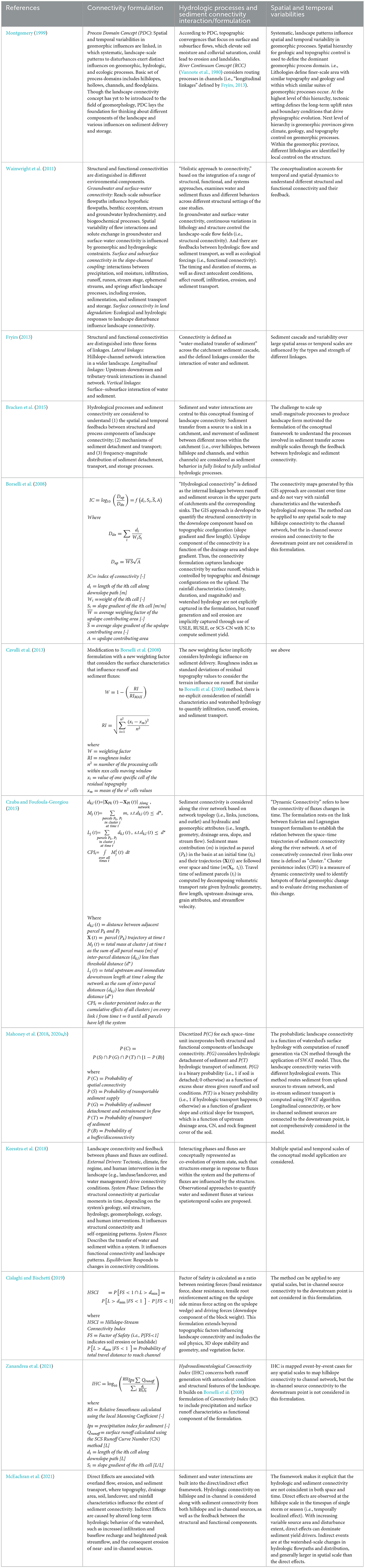
Table 1. Review of landscape sediment connectivity concept and modeling.
Our review of connectivity literature suggests it has long been recognized that the spatial and temporal variabilities in geomorphic influences are linked with distinct hydrologic processes and landscape features (Vannote et al., 1980; Montgomery, 1999; Fryirs, 2013). It also indicates that a systematic harmonization of hydrologic and geomorphic connectivity is needed to explain sediment dynamics in different environmental systems over appropriate time scales and disturbances (Wainwright et al., 2011; Bracken et al., 2015; Keesstra et al., 2018). Strategies and applications of numerical simulation emerged to quantify the topographic influences on sediment delivery, focusing on the structural component of sediment connectivity (e.g., Borselli et al., 2008; Cavalli et al., 2013; Cislaghi and Bischetti, 2019). Later numerical simulation efforts integrated surface hydrodynamics to structural components of sediment connectivity (e.g., Mahoney et al., 2018, 2020a,b; Zanandrea et al., 2021). This selective review of landscape sediment connectivity research undertaken in the last several decades reveals that representation of the interactions between hydrologic and sediment processes remains piecemeal and subjective and depends on specific environmental circumstances (i.e., study site location, catchment characteristics, and methods of inference) (Bracken et al., 2015).
To measure and predict water quality at gage-relevant spatial scales (HUC 8 watershed scales, for example), a model is needed that includes elements for provenance, pathways, and storage along sediment cascades and addresses the response to different hydrologic forcings and landscape disturbances (McEachran et al., 2021). Quantification of sediment sources and delivery for a given landscape would require an effective synthesis of a range of conceptual approaches with monitoring and modeling techniques that integrate hydrologic processes and structural components of sediment connectivity. Spatial variability in geomorphic processes that influence temporal patterns of connectivity may be mapped by identifying sediment sources along with hydrologic pathways. A conceptual model in the following section can help to develop time- and space-variant connectivity scenarios and can guide data collection and model development needed to quantitatively evaluate them.
3 Sediment-hydrologic connectivity
3.1 Conceptual model
While it is impossible to cover all spatial and temporal combinations of sources and transport processes, we put forth an integrated hydrologic and sediment connectivity conceptual model to broadly categorize dominant sediment and hydrologic processes and patterns relevant to understanding and predicting sediment flux dynamics. We consider two major hydrologic pathway s (surface vs. subsurface) and two major sediment sources (upland vs. near/in-channel) of an idealized watershed (Figure 1). Various combinations of hydrologic pathways and sediment sources are associated with different spatial distribution and timing of source erosion, storage, and loading. Figure 1A illustrates sediment source and storage areas in the upland (hillslope and toe slope) and near/in-channel (floodplain and channel). Active sediment sources include areas of stored mass (e.g., fallow field, colluvium at the bottom of hillslope, wetland and other areas of depression, deposits on floodplains, channel beds, and bars) in interaction with watershed hydrology and/or geomorphic drivers. Active sources may change over time, such as throughout a storm hydrograph (e.g., land surface erosion via rainfall impact to streambank erosion from peak flows), or over engineering timeframes with management implementations (e.g., grassed waterways and stream restorations) and up to geomorphic time scales (i.e., landscape evolution and stream morphology). As a result, event water composition and pathways can influence dominant sediment sourcing and routing and appropriate management strategies (McEachran et al., 2021). Therefore, adopted from the idea of variable source area (VSA) (Dunne and Black, 1970), we define the morphological runoff zone (MRZ) to indicate those areas in the watershed where runoff generation results in sediment delivery from upland sources to the river network. Figure 1B illustrates various hydrologic pathways and contributions to streamflow. Through the empirical implications of isotopic compositional differences, streamflow may be separated into event water (often called “new water” indicated with blue arrows in Figure 1B) and pre-event water (“old water” indicated with brown arrows) using the distinct chemical (e.g., isotopic) signals in soil water and groundwater (Klaus and McDonnell, 2013). New water is primarily derived from an ongoing precipitation event (e.g., surface runoff, snowmelt, and direct precipitation). Old water consists primarily of water that is stored in the catchment prior to the stream flow generating precipitation event and delivered primarily through subsurface pathways (e.g., soil water and ground water) (Shanley et al., 2002).

Figure 1. Illustration and definition of (A) sediment sources and storage areas on hillslope (erosion and mass movement) and near/in-channel (floodplains, streambank, bed, and bars) and (B) surface and subsurface hydrologic pathways on hillslope to channels (runoff, infiltration, return flow, percolation, and groundwater flow). The morphological runoff zone indicates the areas of direct surface flow and sediment contributions to the stream.
Hydrologic processes through different pat hways and timing have different effects on structural connectivity as they have access to different sediment sources, storage areas, and transit pathways. For sediment sources in upland areas (A—A' of Figure 1A), the extent of overland flow and the availability of upland sources influences sediment connectivity to the channel network, including slope-channel (e.g., rain splash and sheet erosion) and channel floodplain (e.g., return flow flushing and flood inundation) relations (Wainwright et al., 2011; Fryirs, 2013). The strength and patterns of the connectivity are likely controlled by hillslope hydrology and relationships between precipitation characteristics, antecedent conditions, surface flow, subsurface flow, and ground water (A—A' of Figure 1B). Materials derived upslope and their proximity to the channel network may also be relevant (Wainwright et al., 2011). For sediment sources near/in-channels (B—B' of Figure 1A), the extent of upstream-downstream connectivity reflects the ability of the channel to erode and transfer sediments downstream, which may be assessed in terms of surface and subsurface flow contributions and their timing, stream power, transport regime, and network structure, given the base level or bed profile of the channel (B—B' of Figure 1B) (Fryirs, 2013; Bracken et al., 2015).
Various upland-channel-outlet linkages within a watershed are organized into four dominant sediment and hydrologic connectivity regimes in a conceptual model (Figure 2). The partition on the x-axis broadly categorizes structural characteristics of connectivity, linked to the landscape geomorphology and spatial dimensions of sediment sources. The partition on the y-axis characterizes the functional aspects, linked to the hydrological properties and time-scale variation in sediment connectivity. The conceptual model organizes these different categorizations of dominant sediment and hydrologic processes and patterns to navigate various spatial dimensions and time scales of connectivity. Each sediment and hydrologic connectivity regime illustrates distinct interactions between water and sediment, and they are named based on the primary hydrologic sources relative to the event scale (Old Water vs. New Water) and sediment source areas (Upland vs. Near/in-channel Sources).
Figure 2. Conceptual model of sediment and hydrologic connectivity: OW-US, Old Water-Upland Sources; OW-NS, Old Water-Near/in-channel Sources; NW-US, New Water-Upland Sources; NW-NS, New Water-Near/in-channel Sources.
We propose that in combining hydrologic and sediment connectivity into a single conceptual model, patterns will emerge such that catchments (i.e., small hydrologic units with identifiable dominant processes) will exist in a single characteristic behavior at a particular instance. Furthermore, the conceptual model can describe shifts in dominant processes with different spatial (e.g., reach scale vs. watershed scale of greater hydrologic units) and temporal scales (e.g., seasonally with individual storm events vs. annual trends), as well as with landscape disturbances (e.g., wildfire, landslide, and landuse/landcover change). In other words, the conceptual model can be used to describe the dominant connectivity regime at a particular space and time and its response to landscape disturbance and/or natural variability. As such, the conceptual model can provide guidance to management actions that will need to uniquely address the hydrology and/or sediment connectivity dominant in each watershed given different conservation objectives and timeframes (e.g., control mean daily sediment loading at a gage location and determine effective Best Management Practices). For example, timber harvest or agriculture (or landcover changes more broadly) can result in increased surface runoff and increased upland sediment connectivity affecting local, reach-scale water quality. At the same time, shifts in hydrologic processes due to tree removal or tile drainage (e.g., alterations to evapotranspiration, infiltration, and runoff) may account for the increases in subsurface and surface flows to the stream such that the changes to downstream water quality are not predicated upon overland sediment delivery to the stream but is attributed to in-stream processes (e.g., stream bank erosion, channel meander, incision, and widening) over longer time scales (Foufoula-Georgiou et al., 2015; McEachran et al., 2021). In such cases, management of downstream water quality degradation does not only rely on management actions on uplands to trap sediment but also on controlling watershed hydrology and in-stream erosion processes (McEachran et al., 2021).
3.2 Sediment-hydrologic connectivity scenarios
Recent advancements in landscape observational techniques involving geochemical tracers, remote sensing, increasing availability and frequency of hydrologic monitoring data, and the integration of various data analytic methods (e.g., isotopic hydrograph separation, stormflow concentration–discharge, and hysteretic behavior analysis) and watershed modeling have broadened the spatial and temporal scales of geomorphic observations and understanding of sediment connectivity. Through the descriptions of the anticipated dominant hydrologic and geomorphic regimes using the conceptual model (Figure 2), we examine sediment and hydrologic interactions in real-world examples (Table 2 organizes the following examples by study location, study method, main geomorphic and hydrologic processes, and space/time scales of evaluation):
• Connectivity Scenario: Old Water-Upland Sediment (OW-US)
The OW-US regime indicates that the primary hydrologic drivers consist of pre-event water from subsurface storage and pathways, and the dominant sediment sources consist of upland mass wasting processes and colluvial deposits at the bases of slopes. For example, in headwater streams in mountainous regions dominated by steep confined valleys with little to no flood accommodation areas, landslides and debris flows are important sources of sediment (Ward, 1997). Additionally, if the landscape exhibits high infiltration rates and limited overland flow, streams are mainly charged through groundwater discharge [i.e., Old Water (OW)]. In such a system, stream stages are maintained by baseflow, and connectivity is established with Upland Sediment (US) through flushing temporarily stored colluvium in the valley bottom or through slope failure following rainfall events (e.g., infiltration and drainage, resulting in increased pore pressure, and landsliding). At the same time, the stream sediment delivery capacity is increased for a prolonged period after rainfall events through continued subsurface recharge (Figure 3).
The OW-US scenario may be observed in both colluvial headwater channels and floodplain channels, depending on a site's topographic, geologic, and climatic characteristics. For example, Montgomery et al. (2002) document the accumulation of colluvium from landslides and the importance of shallow bedrock flow in both storm runoff and base flow generation, from which the influence on debris-flow initiation was observed in the colluvium-mantled sites. Similarly, Kukulak et al. (2022) report hydrological factors affecting the rate and patterns of fluvial erosion of landslide colluvium at its contact with river flows along river channels of Podhale in southern Poland. In this study site, groundwater seepage through the landslide tongue toward the channel instigated creep and steep scarp formation within the colluvium exposed at the channel banks. The colluvium deposited from landslide events (in Figure 4, dashed lines mark the colluvial deposit from the landslide above the undisturbed bedrock) was accessed during high flows as the enduring high river stages over many days forced rises of phreatic level in colluvium adjacent to the channel and lowered its friction resistance to failure. On the falling limb, the river water continued to erode the colluvial layer as the pore water drained during a rapid fall of the flood wave when the river is mainly recharged through baseflow. Rise in the groundwater level through infiltration within landslides after a rainfall event also led to the reactivation of slope failure and increased the supply of colluvium to the channels (Kukulak et al., 2022).
In another exampl e from a small stream in the Mid-Atlantic USA, Rose et al. (2018) observed the combination of OW and US loading during an extreme climate event (ECE). During Hurricane Sandy (137 mm of rainfall from 23 to 30 October 2012), spatially variable groundwater inputs to the stream throughout the hydrograph were observed (Sawyer et al., 2014), and fingerprinting of particulate material indicated resuspension and delivery of US in temporary storage within the stream. However, during a previous ECE (Hurricane Irene with 167 mm rainfall over 30 h on 27–28 August 2011), upland source areas throughout the watershed were the primary contributor through precipitation runoff and physical transport on the land surface (see NW-US scenario). This study illustrates that event sediment sourcing and dynamics are closely related to the magnitude and intensity of storm events. In addition, the sourcing of primary sediment depends on characteristics of previous storms and their impact on the extent and rates of erosion in both upland and near-/in-channel. Thus, the understanding of the sediment dynamics over long periods relies on individual events and their sequence.
Table 2. Sediment-hydrologic connectivity scenarios and case studies.
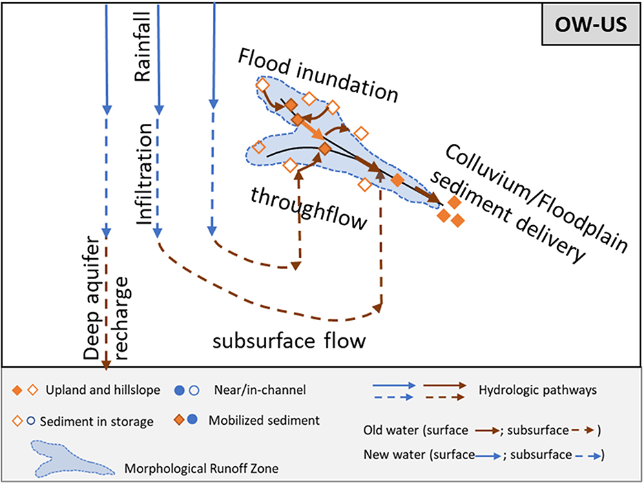
Figure 3. Old Water (OW)-Upland Sediment (US) scenario conceptual model.
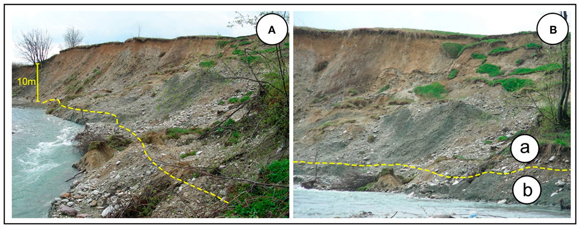
Figure 4. Field photographs (A, B) in Figure 8 from Kukulak et al. (2022) show landslide colluvium along the River Channels of Podhale (Polish Highlands of Western Carpathians) in southern Poland. The dashed lines mark the colluvium deposit from the landslide above the undisturbed bedrock base.
• Connectivity Scenario: New Water-Upland Sediment (NW-US)
The NW-US regime indicates that primary hydrologic drivers consist of event water from precipitation runoff on surface pathways, and the dominant sediment sources consist of upland mass wasting and colluvium stored at the bases of slopes. For example, in a landscape dominated by overland flow with little infiltration, storm flow consists of New Water (NW). Given limited infiltration where rainfall contributes mostly to runoff generation, the MRZ is where overland flow-activated upland sources are greatest in extent, which contrasts with the OW-US scenario. Particularly with the limited availability of near-channel sources (e.g., bedrock, vegetative buffers, gabion walls, and/or other erosion control measures), the main sediment source would consist of US (Figure 5).
The NW-US scenario may be observed in a semiarid environment, where runoff is activated from summer convective storms, snowmelt runoff, and rainfall on snowpacks, which can initiate incision of montane arroyos and gullies (Gellis, 1998). Overland flow generation is critical in soil erosion and delivery, and its patterns are influenced by infiltration (Kirkby and Chorley, 1967; Dunne and Leopold, 1978). Numerical simulation models of hydrological connectivity conducted in semi-arid environments demonstrate that three factors are important in determining the form of discharge hydrographs: topography (slope length, gradient, flow paths, and convergence), lithology (infiltration rates), and vegetation (roughness) at the hillslope-channel connection (Reaney et al., 2014). Thus, detachment and transport of sediment from uplands by overland flow depend on the spatial organization of lithology, topography, and surface roughness (Blackburn, 1975; Reaney et al., 2014). For example, a sediment budget compiled for an arid and grazed small catchment during drought conditions indicates high sediment connectivity between hillslopes and the channel network particularly at headcut locations and gullies (Bartley et al., 2007). At the same time, vegetation in the stream promotes the process of sedimentation and increases the resistance to erosion in dryland river channels (Sandercock et al., 2007). In these conditions, the main sediment contribution is the erosion of upland sources from runoff generation where streams act as a net sediment sink.
Landscape disturbance, such as wildfire, can alter watershed hydrology, leading to the NW-US regime. Saturation overland flow develops in the topographic convergence of valley axes (Dunne and Black, 1970) and in areas of soil water repellency, a common post-fire condition (MacDonald and Huffman, 2004). In such conditions, overland flow and soil erosion processes are enhanced, as observed in an in situ study coupled with rainfall simulation modeling in a fire-prone bluegum eucalyptus (Eucalyptus globulus) plantation in Portugal (Leighton-Boyce et al., 2007). In another study using LiDAR differencing and field observation to map volumes and sources of sediment mobilization from mountain canyons by large post-wildfire debris flows in Montecito, California, it is shown that the largest contribution of sediment was bouldery colluvium and debris-flow accumulation activated by a brief, intense rainstorm (Morell et al., 2021). The extent, pattern, and volumes of post-fire hillslope erosion depended on rainfall, runoff, landscape characteristics, and burn severity. In the same study site in Montecito, the distribution of rills and cross-sectional geometries was mapped on burned hillslopes in the source catchments to demonstrate that different lithological and topographic features affect the extent and dimensions of rills and volumes of slurry mixing of water and sediment (Alessio et al., 2021). Figure 6 illustrates post-rainstorm rill erosion on burned hillslopes of different bedrock compositions from Alessio et al. (2021). Though in-stream erosion can contribute to the overall sediment loading during post-fire storm events, upland sources (ridgetops and steep valley sideslopes) made up the dominant part of the sediment budget given post-fire erosion susceptibility in hillslopes according to a sediment budget analysis using fallout radionuclide (FRN) tracers by Blake et al. (2009). In fact, post-fire conditions can shift dominant sediment sources from gully and riverbank erosion to topsoil derived from hillslope surface erosion. With fire occurrences, transport-limited conditions can be created in channel conduits, where in-channel and floodplains are more likely to store sediment, particularly with high interannual hydrologic variability (Wilkinson et al., 2009).
Additionally, anthropogenic lands cape disturbances, such as urbanization and intensive agriculture, particularly without effective soil conservation in upland areas, can accelerate erosion of topsoil, creating NW-US scenarios. Wolman (1967) presented the process of urbanization of the landscape, particularly from the period of construction, linked to large pulses of sediment yield. Agriculture can also accelerate upland and hillslope erosion, compared to native vegetation and long-term geologic erosion (Montgomery, 2007). Prior to the widespread adoption of agricultural soil erosion control measures (e.g., conservation tillage, grassed waterways, and buffers), upland sources have contributed dominantly to sediment budgets (Trimble, 1985). For example, a sediment fingerprinting study in the Upper Mississippi River Basin demonstrates a pulse of soil erosion from agricultural fields during the mid-20th century, followed by a subsequent shift back toward near-channel sources (i.e., see NW-NS scenario) in the recent decades after widespread agricultural soil erosion control measures were adopted in the region (Belmont et al., 2011).
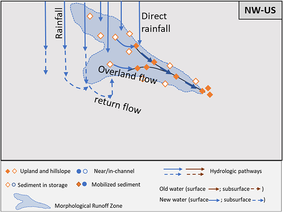
Figure 5. New Water (NW)-Upland Sediment (US) scenario conceptual model.
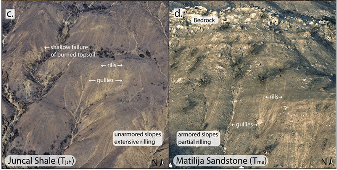
Figure 6. Field photographs c and d in Figure 4 from Alessio et al. (2021) show the field condition in extensive rilling on Juncal shale (c) vs. partial rilling on the Matilija sandstone through aerial image taken about a month after the rainstorms that generated rills (d). In Juncal shale aerial imagery, dark-colored patches represent the upper 4–5 cm of burnt soil, and lighter streaks are rills and gullies. In Matiligia sandstone, armored slopes with bedrock outcrop disrupted rill network development.
• Connectivity Scenario: New Water-Near/in-Channel Sediment (NW-NS)
The NW-NS regime indicates that primary hydrologic drivers consist of event water from precipitation runoff on surface pathways, and the dominant sediment sources consist of near/in-channel erosional processes. For instance, in a landscape system with small infiltration rates, overland precipitation runoff, and drainage management (e.g., ditches, tiles, and other artificial drainage) control the rapid overland movement of water. Subsequently, streams are flooded with large quantities of NW increasing the erosivity and delivery capacity of the channel during the rainfall event. With the limited availability of overland sediment sources (e.g., impervious surface, vegetative cover, and/or erosion control measures), the primary sediment sources consist of Near-channel Sediment (NS) (Figure 7).
Anthropogenic landscape disturbance, such as urbanization or intensive agriculture, can alter watershed hydrology and impact dominant sediment sources, leading to a NW-NS scenario. In a study that examines the effects of urbanization on hydrology, it is shown that impervious surfaces and stormwater drainage systems increase and drive runoff (i.e., NW) and amplify the overall peak flood discharge and duration (Paul and Meyer, 2001), which is followed by channel erosion and channel widening or enlargement (i.e., NS), while the sediment production from urbanized landscapes is minimal (Chin, 2006). In a Mid-Atlantic urban stream in Maryland, runoff from impervious surfaces and storm drain network have resulted in high peak flows in open channels, leading to channel widening, streambank erosion, and channel incision (Figure 8) as verified by the numerical tagging of 7Be and 210Pbex activities (Gellis et al., 2020). Similarly, studies using sediment sampling, elemental tracers, and radionuclide analysis in urban watersheds in Maryland and Virginia show that streambank contributed the greatest quantity of fine sediment (Devereux et al., 2010; Cashman et al., 2018) to the Chesapeake Bay.
Additionally, agricultural tile drainage (Figure 9), particularly at shallow depths or with narrow spacing, is often considered to carry a characteristic concentration–discharge signature of surface runoff (Radcliffe et al., 2015; Smith et al., 2015, 2019). Tile drainage networks and ditch systems have artificially extended the drainage of many watersheds with low permeability on the flat terrain of the headwaters of the Mississippi River Basin (Kelley and Nater, 2000). A modeling study with stream monitoring data from various locations across south-central Minnesota, in which ~96% of the cultivated land is in tile drainage, evaluates the impacts of altered hydrology on sediment sources (Dalzell and Mulla, 2018). Under current watershed conditions, ~76% of sediment loading originates from non-field sources, including streambanks and ravines because of increased water yield and streamflow. The modeling results of alternate landscape management demonstrate that a relatively minor shift in cropping systems to include more perennial vegetation, or conservation practices to effectively store more water on the landscape, showed the potential to reduce significant sediment export by changing the water budget of the landscape, illustrating the important coupling between sediment sources and watershed hydrology (Dalzell and Mulla, 2018).
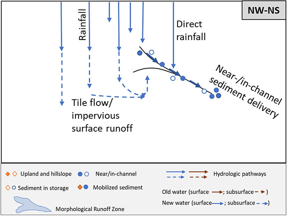
Figure 7. New Water (NW)-Near/in-channel Sediment (NS) scenario conceptual model.
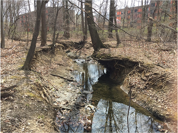
Figure 8. Channel enlargement (location of tree roots indicate original location of channel bank) caused by urban runoff in an urban stream in Baltimore, Maryland [Photo Source: Allen Gellis (USGS) as appear in Figure 2B of Gellis et al. (2020)].

Figure 9. Agricultural artificial subsurface tiles draining to a ditch system (photo source: University of Minnesota Extension; https://extension.umn.edu/agricultural-drainage/how-agricultural-drainage-works).
• Connectivity Scenario: Old Water-Near/in-Channel Sediment (OW-NS)
The OW-NS regime indicates that the primary hydrologic drivers consist of pre-event water from subsurface storage, and the dominant sediment sources consist of near/in-channel erosional processes. For instance, in a landscape dominated by steep confined valleys with little to no flood accommodation areas, where stream flow is mainly charged through subsurface flow (OW), the erosivity and delivery capacity of the river are heightened with increased stream flow for a prolonged period following a rain event. In such a system the major sediment contribution consists of near/in-channel sediment sources (NS) through incision, widening, and lateral channel migration of meander (Figure 10).
In a comparative study of hydrogeological control on hysteresis, Lloyd et al. (2016) demonstrate that in a groundwater-dominated mixed-landuse watershed, slow-changing baseflow with relatively attenuated but flashy responses is observed during storm events. Short-term discharge dynamics affected the hysteretic direction and strength, and the antecedent conditions influenced the hysteretic behavior, indicating the importance of hydrologic residence time on sediment sources and mobilization (Lloyd et al., 2016). Stron g clockwise hysteresis occurred during larger storm events, indicating that flushing of readily erodible near- and in-channel sources might dominate sediment loading in the river system. Alternately, Rose and Karwan (2021) infer major sediment sources from concentration–discharge relationships and chemodynamics of Plum Creek in northeastern Wisconsin: Strong anti-clockwise hysteresis is associated with streambank failure observable in the incised channels, which can mobilize large amounts of suspended materials to the stream, as the storm water recedes under baseflow conditions (i.e., Old Water/Near-channel Sediment). These examples demonstrate that the main sources of sediment (upland vs. near-channel) depend on watershed wetness (i.e., antecedent precipitation indices) from previous events. Thus, OW-NS can readily shift to a different regime event by event. The understanding of the sediment dynamics over long periods relies on individual events and their sequence.
In another example, a comprehensive sediment budget was developed using multiple lines of evidence, ranging from field surveys, stream gaging, and sediment fingerprinting to remote-sensing analysis in the Le Sueur River Basin of south-central Minnesota, which is undergoing a transient incisional process following the initial carving of the landscape ~13,000 years ago that created the baselevel drop of up to 65 m from the surrounding drainage basins to the Minnesota River Valley (Gran et al., 2013). As a result, bluffs as tall as 65 m comprise 1,280 km of channel in the knick zone of the watershed–a high-gradient reaches that have adjusted to the new baselevel (Figure 11). Sapping from groundwater and freeze-thaw processes, along with toe erosion through fluvial abrasion and shear, have weakened and eroded till material on bluffs of the Le Sueur River (i.e., NS) (Day et al., 2013b). Evaluation of the sediment supply in the watershed, derived from geochemical fingerprinting and a suite of geomorphic change detection techniques, indicates that although agricultural soil erosion remains large, the dominant sediment source has shifted from agricultural field erosion to accelerated erosion and over steepening of stream banks and bluffs, driven by increased river discharge (Belmont et al., 2011). In a regional analysis of stable water isotopes, deuterium, and oxygen-18 data from agricultural landscapes of western South Dakota to eastern Minnesota show that precipitation took an average of 9 months to move through different pathways (Zhang et al., 2022). Given the watershed configuration that progressively narrows toward the outlet, along with the independent assessment of water residence time in the region, the water discharge in the incised section of the Le Sueur River likely consists of water that traveled through tiles, ditches, and subsurface pathways from the flat upper portion of the watershed over many months (i.e., OW).
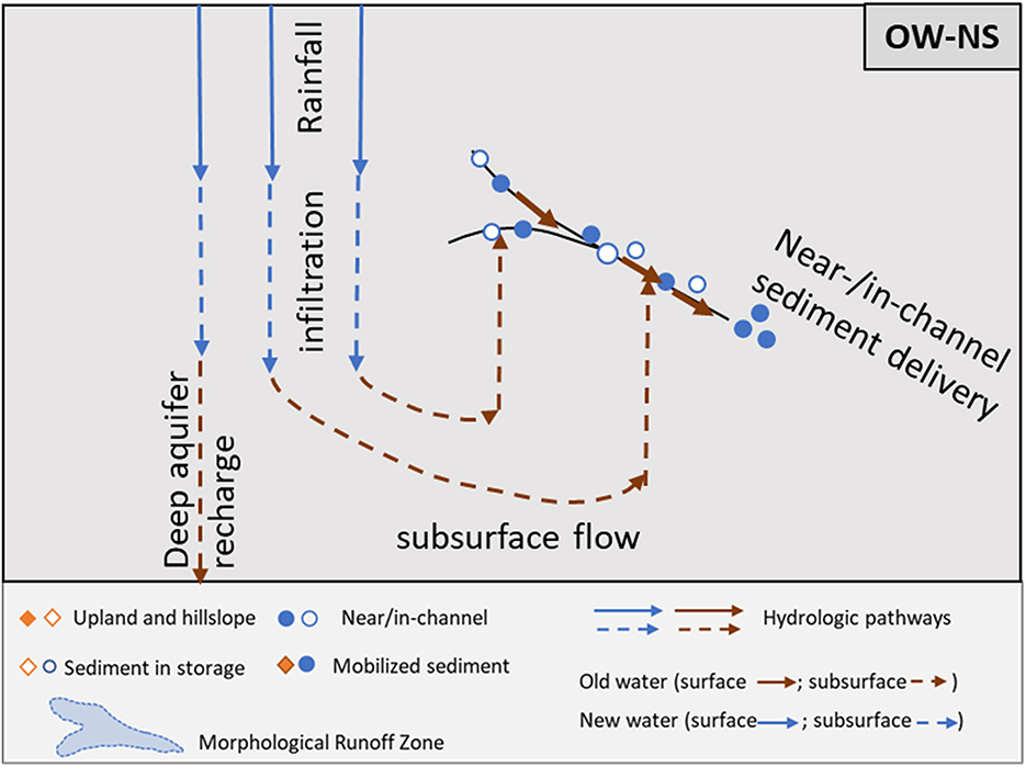
Figure 10. Old Water (OW)-Near/in-channel Sediment (NS) scenario conceptual model.

Figure 11. Field photograph from Mankato State University Water Resource Center (top) shows a typical bluff face along the Le Sueur River with kayakers as a scale. Image C in Figure 7 from Day et al. (2013a) (bottom) shows a normally consolidated till bluff where erosion at the top face of the bluff and deposition at the toe are mapped between 2007 and 2008 with terrestrial laser scanning (TLS).
4 Next steps: applying the sediment-hydrologic connectivity conceptual model
The conceptual model and case studies using various observational and modeling techniques can provide guidance for collecting and assembling environmental data. For instance, through the synthesis of existing datasets and monitoring sites with new, coordinated sampling, we can investigate how hydrologic and sediment connectivity affect sediment mobilization at different spatiotemporal scales as illustrated in the selected case studies. In addition, an understanding of how dominant processes shift with different environmental forcing and/or landscape disturbances may be derived from strategic data assemblage using the conceptual model (e.g., various observational and modeling approaches to characterize post-fire sediment delivery described in the NW-US scenarios). Specifically, the collection of distinct isotopic signals in stream water samples collected for various storm events across the watershed can help to characterize dominant flow pathways and residence times at different spatial scales from reaches to basin outlets. Remote-sensing analysis coupled with stream gaging and chemical tracers collected and aggregated over different spatial and temporal scales can provide critical guidance on dominant sediment sources and how they shift with storm size and with changing temporal and spatial scales. For more discussion on environmental measurement techniques for system fluxes (e.g., water discharge and sediment delivery) vs. system phases (e.g., geology, soil, ecology, and geomorphology) to design effective measurement schemes and models at different scales, refer to Keesstra et al. (2018) and the various observational approaches highlighted in the case studies of the previous section.
Numerical simulation of landscape connectivity combined with strategic data collection can help to effectively evaluate and forecast sediment delivery, transport, and storage across spatial and temporal scales and to predict how connectivity shifts with different environmental forcing and landscape disturbances. The conceptual model will be particularly useful when compiling relevant data to characterize water and sediment connectivity using data-driven analyses such as machine-learning (ML) applications. For example, ML models have been developed to predict sediment transport from a wide range of publicly available environmental features by training them with physically collected water and sediment samples (Lund et al., 2022). The more efficient assemblage of available geospatial data could help model interpretation and prediction accuracy. It has been noted that dataset biases occur in ML applications when the training data are not fully representative of the landscape characteristics and planned uses, and the results can be contaminated with the desired outcome and user biases (Zhong et al., 2021). The conceptual model proposed here can be used to check the implicit biases toward desired outcomes by considering the broad spectrum of sediment and hydrologic processes.
5 Conclusion
The understanding of changing sediment and water dynamics over different spatial and temporal scales, under a range of environmental conditions, is critical for developing monitoring and modeling approaches to quantify and predict sediment loading, as well as, for developing effective water quality management strategies. The conceptualization and application of sediment connectivity are reviewed in terms of how they frame the continuum of sediment sources, stores, and routes of transport operating under different hydrologic conditions. The landscape connectivity research in recent decades indicates that both sediment connectivity and hydrologic processes affect provenance, pathways, and storages along the sediment cascade and influence their timing and magnitude. We propose an integrated hydrologic and sediment connectivity conceptual model to broadly categorize dominant sediment and hydrologic processes and patterns relevant to understanding and predicting sediment flux dynamics. Using the conceptual model as a “thinking” tool, we extract case studies from a multidisciplinary literature review—from hydrology, geomorphology, biogeochemistry, and watershed modeling to remote-sensing technology—that correspond to each of the dominant hydrologic–sediment connectivity regimes to examine sediment and water interactions in real-world examples using various observational and modeling techniques. The conceptual model and case studies provide an important foundation for advancing the understanding and predictive capability of watershed sediment processes at multiple spatiotemporal scales and various environmental conditions.
Author contributions
SJC, DLK, KS, JP, and MEH contributed to conception and design of the study. SJC organized and reviewed the literature and wrote the first draft of the manuscript. SJC and DLK wrote sections of the manuscript. All authors contributed to manuscript revision, read, and approved the submitted version.
Funding
This study was funded by the U.S. Geological Survey's Mendenhall Postdoctoral Fellowship (SJC). DLK received funding from the USGS Water Resources Research Act Program. Foundational work was done under NSF EAR 1424147 by DLK, KS, and JP.
Acknowledgments
The authors like to thank the support of the USGS peers, Trevor F. Partridge and Michelle P. Katoski and two reviewers who helped them improve the manuscript. The authors are also grateful to those who provided and permitted the use of illustrative images and photographs: Paul Alessio of University of California, Santa Barbara; JoAnne Makela of University of Minnesota Extension; Brent Dalzell of USDA Agricultural Research Service; Kimberly Musser of Water Resources Center, Minnesota State University, Mankato; and Jozef Kukulak et al., and Day et al., whose full citations can be found in the References. Any use of trade, firm, or product names is for descriptive purposes only and does not imply endorsement by the U.S. Government.
Conflict of interest
The authors declare that the research was conducted in the absence of any commercial or financial relationships that could be construed as a potential conflict of interest.
Publisher's note
All claims expressed in this article are solely those of the authors and do not necessarily represent those of their affiliated organizations, or those of the publisher, the editors and the reviewers. Any product that may be evaluated in this article, or claim that may be made by its manufacturer, is not guaranteed or endorsed by the publisher.
References
Alessio, P., Dunne, T., and Morell, K. (2021). Post-wildfire generation of debris-flow slurry by rill erosion on colluvial hillslopes. J. Geophys. Res. 126, e2021JF006108. doi: 10.1029/2021JF006108
Bartley, R., Hawdon, A., Post, D. A., and Roth, C. H. (2007). A sediment budget for a grazed semi-arid catchment in the Burdekin basin, Australia. Geomorphology 87, 302–321. doi: 10.1016/j.geomorph.2006.10.001
Belmont, P., Gran, K. B., Schottler, S. P., Wilcock, P. R., Day, S. S., Jennings, C., et al. (2011). Large shift in source of fine sediment in the Upper Mississippi River. Environ. Sci. Technol. 45, 8804–8810. doi: 10.1021/es2019109
Blackburn, W. H. (1975). Factors influencing infiltration and sediment production of semiarid Rangelands in Nevada. Water Resources Research 11, 929–937. doi: 10.1029/WR011i006p00929
Blake, W. H., Wallbrink, P. J., Wilkinson, S. N., Humphreys, G. S., Doerr, S. H., Shakesby, R. A., et al. (2009). Deriving hillslope sediment budgets in wildfire-affected forests using fallout radionuclide tracers. Geomorphology 104, 105–116. doi: 10.1016/j.geomorph.2008.08.004
Borselli, L., Cassi, P., and Torri, D. (2008). Prolegomena to sediment and flow connectivity in the landscape: a GIS and field numerical assessment. Catena 75, 268–277. doi: 10.1016/j.catena.2008.07.006
Bracken, L. J., Turnbull, L., Wainwright, J., and Bogaart, P. (2015). Sediment connectivity: a framework for understanding sediment transfer at multiple scales. Earth Surface Proc. Landf. 40, 177–188. doi: 10.1002/esp.3635
Bunn, A. G., Urban, D. L., and Keitt, T. H. (2000). Landscape connectivity: a conservation application of graph theory. J. Environ. Manag. 59, 265–278. doi: 10.1006/jema.2000.0373
Cashman, M. J., Gellis, A., Sanisaca, L. G., Noe, G. B., Cogliandro, V., and Baker, A. (2018). Bank-derived material dominates fluvial sediment in a suburban Chesapeake Bay watershed. River Res. Applic. 34, 1032–1044. doi: 10.1002/rra.3325
Cavalli, M., Trevisani, S., Comiti, F., and Marchi, L. (2013). Geomorphometric assessment of spatial sediment connectivity in small Alpine catchments. Geomorphology 188, 31–41. doi: 10.1016/j.geomorph.2012.05.007
Chin, A. (2006). Urban transformation of river landscapes in a global context. Geomorphology 79, 460–487. doi: 10.1016/j.geomorph.2006.06.033
Cho, S. J., Wilcock, P., and Gran, K. (2022). Implementing landscape connectivity with topographic filtering model: a simulation of suspended sediment delivery in an agricultural watershed. Sci. Total Environ. 836, 155701. doi: 10.1016/j.scitotenv.2022.155701
Cho, S. J., Wilcock, P., and Hobbs, B. (2018). Topographic filtering simulation model for sediment source apportionment. Geomorphology 309, 1–19. doi: 10.1016/j.geomorph.2018.02.014
Cho, S. J., Wilcock, P. R., Belmont, P., Gran, K. B., and Hobbs, B. F. (2019). Simulation model for collaborative decision making on sediment source reduction in an intensively managed watershed. Water Resour. Res. 55, 1544–1564. doi: 10.1029/2018WR024324
Cislaghi, A., and Bischetti, G. B. (2019). Source areas, connectivity, and delivery rate of sediments in mountainous-forested hillslopes: a probabilistic approach. Sci. Total Environ. 652, 1168–1186. doi: 10.1016/j.scitotenv.2018.10.318
Czuba, J. A. (2018). A lagrangian framework for exploring complexities of mixed-size sediment transport in gravel-bedded river networks. Geomorphology 321, 146–152. doi: 10.1016/j.geomorph.2018.08.031
Czuba, J. A., and Foufoula-Georgiou, E. (2015). Dynamic connectivity in a fluvial network for identifying hotspots of geomorphic change. Water Resour. Res. 51, 1401–1421. doi: 10.1002/2014WR016139
Dalzell, B. J., and Mulla, D. J. (2018). Perennial vegetation impacts on stream discharge and channel sources of sediment in the minnesota river basin. J. Soil Water Conserv. 73, 120–132. doi: 10.2489/jswc.73.2.120
Day, S. S., Gran, K. B., Belmont, P., and Wawrzyniec, T. (2013a). Measuring bluff erosion part 1: terrestrial laser scanning methods for change detection. Earth Surface Proc. Landforms 38, 1055–1067. doi: 10.1002/esp.3353
Day, S. S., Gran, K. B., Belmont, P., and Wawrzyniec, T. (2013b). Measuring bluff erosion part 2: pairing aerial photographs and terrestrial laser scanning to create a watershed scale sediment budget. Earth Surface Proc. Landforms 38, 1068–1082. doi: 10.1002/esp.3359
Devereux, O. H., Prestegaard, K. L., Needelman, B. A., and Gellis, A. C. (2010). Suspended-sediment sources in an urban watershed, Northeast Branch Anacostia River, Maryland. Hydrol. Proc. 24, 1391–1403. doi: 10.1002/hyp.7604
Dunne, T., and Black, R. D. (1970). Partial area contributions to storm runoff in a small new England watershed. Water Resour. Res. 6, 1296–1311. doi: 10.1029/WR006i005p01296
Dunne, T., and Leopold, L. B. (1978). Water in Environmental Planning. New York: W.H. Freeman and Co.
Fortuin, K. P., Van Koppen, C. S. A., and Leemans, R. (2011). The value of conceptual models in coping with complexity and interdisciplinarity in environmental sciences education. BioScience 61, 802–814. doi: 10.1525/bio.2011.61.10.10
Foufoula-Georgiou, E., Takbiri, Z., Czuba, J. A., and Schwenk, J. (2015). The change of nature and the nature of change in agricultural landscapes: hydrologic regime shifts modulate ecological transitions. Water Resour. Res. 51, 6649–6671. doi: 10.1002/2015WR017637
Fryirs, K. (2013). (Dis)Connectivity in catchment sediment cascades: a fresh look at the sediment delivery problem. Earth Surface Proc. Landforms 38, 30–46. doi: 10.1002/esp.3242
Gellis, A. C. (1998). Characterization and Evaluation of Channel and Hillslope Erosion on the Zuni Indian Reservation, New Mexico, 1992-95. U.S. Department of the Interior, U.S. Geological Survey.
Gellis, A. C., Fuller, C. C., Van Metre, P. C., Mahler, B. J., Welty, C., Miller, A. J., et al. (2020). Pavement alters delivery of sediment and fallout radionuclides to urban streams. J. Hydrol. 588, 124855. doi: 10.1016/j.jhydrol.2020.124855
Gran, K. B., Finnegan, N., Johnson, A. L., Belmont, P., Wittkop, C., and Rittenour, T. (2013). Landscape evolution, valley excavation, and terrace development following abrupt postglacial base-level fall. Bulletin 125, 1851–1864. doi: 10.1130/B30772.1
Hewlett, J. D., and Hibbert, A. R. (1963). Moisture and energy conditions within a sloping soil mass during drainage. J. Geophys. Res. 68, 1081–1087. doi: 10.1029/JZ068i004p01081
Karwan, D. L., Pizzuto, J. E., Aalto, R., Marquard, J., Harpold, A., Skalak, K., et al. (2018). Direct channel precipitation and storm characteristics influence short-term fallout radionuclide assessment of sediment source. Water Resour. Res. 54, 4579–4594. doi: 10.1029/2017WR021684
Keesstra, S., Nunes, J. P., Saco, P., Parsons, T., Poeppl, R., Masselink, R., et al. (2018). The way forward: Can connectivity be useful to design better measuring and modelling schemes for water and sediment dynamics? Sci. Total Environ. 644, 1557–1572. doi: 10.1016/j.scitotenv.2018.06.342
Kelley, D. W., and Nater, E. A. (2000). Historical sediment flux from three watersheds into Lake Pepin, Minnesota, USA. J. Environ. Quality 29, 561–568. doi: 10.2134/jeq2000.00472425002900020025x
Kirkby, M. J., and Chorley, R. J. (1967). Throughflow, overland flow and erosion. Int. Assoc. Sci. Hydrol. Bull. 12, 5–21. doi: 10.1080/02626666709493533
Klaus, J., and McDonnell, J. J. (2013). Hydrograph separation using stable isotopes: review and evaluation. J. Hydrol. 505, 47–64. doi: 10.1016/j.jhydrol.2013.09.006
Kukulak, J., Augustowski, K., and Olszak, J. (2022). Factors affecting the rates and modes of landslide colluvium removal in river channels of Podhale (Western Carpathians). Water 14, 3577. doi: 10.3390/w14213577
Leighton-Boyce, G., Doerr, S. H., Shakesby, R. A., and Walsh, R. P. D. (2007). Quantifying the impact of soil water repellency on overland flow generation and erosion: a new approach using rainfall simulation and wetting agent on in situ soil. Hydrol. Proc. 21, 2337–2345. doi: 10.1002/hyp.6744
Lloyd, C. E., Freer, J. E., Johnes, P. J., and Collins, A. L. (2016). Using hysteresis analysis of high-resolution water quality monitoring data, including uncertainty, to infer controls on nutrient and sediment transfer in catchments. Sci. Total Environ. 543, 388–404. doi: 10.1016/j.scitotenv.2015.11.028
Lund, J. W., Groten, J. T., Karwan, D. L., and Babcock, C. (2022). Using machine learning to improve predictions and provide insight into fluvial sediment transport. Hydrol. Proc. 36, e14648. doi: 10.1002/hyp.14648
MacDonald, L. H., and Huffman, E. L. (2004). Post-fire soil water repellency. Soil Sci. Soc. Am. J. 68, 1729–1734. doi: 10.2136/sssaj2004.1729
Mahoney, D. T., Fox, J., Al-Aamery, N., and Clare, E. (2020a). Integrating connectivity theory within watershed modelling part i: model formulation and investigating the timing of sediment connectivity. Sci. Total Environ. 740, 140385. doi: 10.1016/j.scitotenv.2020.140385
Mahoney, D. T., Fox, J., Al-Aamery, N., and Clare, E. (2020b). Integrating connectivity theory within watershed modelling part II: Application and evaluating structural and functional connectivity. Sci. Total Environ. 740, 140386. doi: 10.1016/j.scitotenv.2020.140386
Mahoney, D. T., Fox, J. F., and Al Aamery, N. (2018). Watershed erosion modeling using the probability of sediment connectivity in a gently rolling system. J. Hydrol. 561, 862–883. doi: 10.1016/j.jhydrol.2018.04.034
McEachran, Z. P., Karwan, D. L., and Slesak, R. A. (2021). Direct and indirect effects of forest harvesting on sediment yield in forested watersheds of the United States. JAWRA 57, 1–31. doi: 10.1111/1752-1688.12895
Montgomery, D. R. (1999). Process domains and the river continuum. JAWRA J. 35, 397–410. doi: 10.1111/j.1752-1688.1999.tb03598.x
Montgomery, D. R. (2007). Soil erosion and agricultural sustainability. Proc. Natl. Acad. Sci. 104, 13268–13272. doi: 10.1073/pnas.0611508104
Montgomery, D. R., Dietrich, W. E., and Heffner, J. T. (2002). Piezometric response in shallow bedrock at CB1: Implications for runoff generation and landsliding. Water Resour. Res. 38, 10–11. doi: 10.1029/2002WR001429
Morell, K. D., Alessio, P., Dunne, T., and Keller, E. (2021). Sediment recruitment and redistribution in mountain channel networks by post-wildfire debris flows. Geophys. Res. Lett. 48, 24. doi: 10.1029/2021GL095549
Paul, M. J., and Meyer, J. L. (2001). Streams in the urban landscape. Ann. Rev. Ecol. System. 32, 333–365. doi: 10.1146/annurev.ecolsys.32.081501.114040
Radcliffe, D. E., Reid, D. K., Blombäck, K., Bolster, C. H., Collick, A. S., Easton, Z. M., et al. (2015). Applicability of models to predict phosphorus losses in drained fields: a review. J. Environ. Quality 44, 614–628. doi: 10.2134/jeq2014.05.0220
Reaney, S. M., Bracken, L. J., and Kirkby, M. J. (2014). The importance of surface controls on overland flow connectivity in semi-arid environments: results from a numerical experimental approach. Hydrol. Proc. 28, 2116–2128. doi: 10.1002/hyp.9769
Rose, L. A., and Karwan, D. L. (2021). Stormflow concentration–discharge dynamics of suspended sediment and dissolved phosphorus in an agricultural watershed. Hydrol. Proc. 35, e14455. doi: 10.1002/hyp.14455
Rose, L. A., Karwan, D. L., and Aufdenkampe, A. K. (2018). Sediment fingerprinting suggests differential suspended particulate matter formation and transport processes across hydrologic regimes. J. Geophys. Res. 123, 1213–1229. doi: 10.1002/2017JG004210
Sandercock, P. J., Hooke, J. M., and Mant, J. M. (2007). Vegetation in dryland river channels and its interaction with fluvial processes. Progr. Phys. Geogr. 31, 107–129. doi: 10.1177/0309133307076106
Sawyer, A. H., Kaplan, L. A., Lazareva, O., and Michael, H. A. (2014). Hydrologic dynamics and geochemical responses within a floodplain aquifer and hyporheic zone during hurricane sandy. Water Resour. Res. 50, 4877–4892. doi: 10.1002/2013WR015101
Shanley, J. B., Kendall, C., Smith, T. E., Wolock, D. M., and McDonnell, J. J. (2002). Controls on old and new water contributions to stream flow at some nested catchments in Vermont, USA. Hydrol. Proc. 16, 589–609. doi: 10.1002/hyp.312
Smith, D. R., King, K. W., Johnson, L., Francesconi, W., Richards, P., Baker, D., et al. (2015). Surface runoff and tile drainage transport of phosphorus in the midwestern United States. J. Environ. Quality 44, 495–502. doi: 10.2134/jeq2014.04.0176
Smith, D. R., Macrae, M. L., Kleinman, P. J. A., Jarvie, H. P., King, K. W., and Bryant, R. B. (2019). The latitudes, attitudes, and platitudes of watershed phosphorus management in North America. J. Environ. Quality 48, 1176–1190. doi: 10.2134/jeq2019.03.0136
Trimble, S. W. (1985). Perspectives on the history of soil erosion control in the eastern United States. Agric. Hist. 59, 162.
Vannote, R. L., Minshall, G. M., Cummins, K. W., Sedell, J. R., and Cushing, C. E. (1980). The river continuum concept. Canad. J. Fisher. Aquat. Sci. 37, 130–137. doi: 10.1139/f80-017
Wainwright, J., Turnbull, L., Ibrahim, T. G., Lexartza-Artza, I., Thornton, S. F., and Brazier, R. E. (2011). Linking environmental regimes, space and time: Interpretations of structural and functional connectivity. Geomorphology 126, 387–404. doi: 10.1016/j.geomorph.2010.07.027
Ward, J. V. (1997). An expansive perspective of riverine landscapes: pattern and process across scales. GAIA Ecol. Perspect. Sci. Soc. 6, 52–60. doi: 10.14512/gaia.6.1.6
Wilkinson, S. N., Wallbrink, P. J., Hancock, G. J., Blake, W. H., Shakesby, R. A., and Doerr, S. H. (2009). Fallout radionuclide tracers identify a switch in sediment sources and transport-limited sediment yield following wildfire in a eucalypt forest. Geomorphology 110, 140–151. doi: 10.1016/j.geomorph.2009.04.001
Wohl, E., Magilligan, F. J., and Rathburn, S. L. (2017). Introduction to the special issue: connectivity in geomorphology. Geomorphology 277, 1–5. doi: 10.1016/j.geomorph.2016.11.005
Wolman, M. G. (1967). A cycle of sedimentation and erosion in urban river channels. Geografiska Annaler 49, 385–395. doi: 10.1080/04353676.1967.11879766
Zanandrea, F., Michel, G. P., Kobiyama, M., Censi, G., and Abatti, B. H. (2021). Spatial-temporal assessment of water and sediment connectivity through a modified connectivity index in a subtropical mountainous catchment. Catena 204, 105380. doi: 10.1016/j.catena.2021.105380
Zhang, L., Magner, J., and Strock, J. (2022). Exploring a climate gradient of Midwestern USA agricultural landscape runoff using deuterium (δD) and oxygen-18 (δ18O). Water 14, 1629. doi: 10.3390/w14101629
Keywords: sediment, hydrological (dis)connectivity, hydrological (water) cycle, sediment delivery, sediment connectivity, sediment–surface runoff, connectivity, sediment–water interface
Citation: Cho SJ, Karwan DL, Skalak K, Pizzuto J and Huffman ME (2023) Sediment sources and connectivity linked to hydrologic pathways and geomorphic processes: a conceptual model to specify sediment sources and pathways through space and time. Front. Water 5:1241622. doi: 10.3389/frwa.2023.1241622
Received: 16 June 2023; Accepted: 20 October 2023;
Published: 23 November 2023.
Edited by:
Ronald Erwin Pöppl, University of Vienna, AustriaReviewed by:
Andrew Stumpf, University of Illinois at Urbana-Champaign, United StatesJohn Pitlick, University of Colorado Boulder, United States
Copyright © 2023 Cho, Karwan, Skalak, Pizzuto and Huffman. This is an open-access article distributed under the terms of the Creative Commons Attribution License (CC BY). The use, distribution or reproduction in other forums is permitted, provided the original author(s) and the copyright owner(s) are credited and that the original publication in this journal is cited, in accordance with accepted academic practice. No use, distribution or reproduction is permitted which does not comply with these terms.
*Correspondence: Se Jong Cho, c2Nob0B1c2dzLmdvdg==