 Raj Rengalakshmi
 Perumal Thamizoli2
- 1M S Swaminathan Research Foundation, Chennai, India
- 2Independent Researcher, Chennai, India
Introduction: The tank cascade system is an interconnected tank/pond managed with local norms and social capital governed by informal institutions. These linkages closely connect people, water, and the environment in the interface of resource management for livelihoods and ecosystem services. However, in the recent past, these cascading structures have been disrupted at the hydrological and social levels, leading to complex issues with increasing climate risks and farmers’ vulnerabilities.
Methods: An in-depth study was carried out in a tank cascade system covering 14 tanks in a geographical area of 4,437 ha in South India to understand its impacts on local livelihoods, ecology, and social networks. The study adopted a mix of qualitative and quantitative methods and remote sensing data to understand the drivers of tank performance, local livelihoods, agricultural production, land use, rainfall, and interconnectedness, with a study period from 2004 to 2024.
Results: The study analysed hydrological, social, and economic dimensions and their interconnected human-environmental interactions. The dependence on tanks for irrigation by farmers in the study area has decreased, ranging from 9 to 54%. There has been a significant change in land use; a 44% reduction in the area under cropping (1,707 ha to 954 ha), with a 13% increase in fallow land (1,607 ha to 1,822 ha) and a 43% increase in other vegetation and built-up area from 5 ha to 60 ha. The surface runoff has increased from 2029 to 2,489 ha-m, while the groundwater level shows a decreasing trend of 0.03 m below ground level (bgl) at pre-monsoon and 0.73 m bgl at the post-monsoon period, with an increase in well intensity in the ayacut area (the entire extent of land irrigated by the tank). The tank infrastructures are undergoing severe degradation, with a shift from community-based collective surface water irrigation to groundwater-based individual irrigation. The social capital and interconnectedness among the farmers are changing along with the declining relevance of community-based water governance and management systems.
Discussion: In the context of changing functional use of tanks from irrigation to groundwater recharge, tank cascade system-based infrastructure, knowledge, and its ecosystem services are on the verge of disappearance. The hydrological status of the tank cascades is closely interconnected with good governance and strategies for the sustainability of institutions in social and financial dimensions. This requires both the right policy and a translational framework to put tank cascades at the centre of the tank development plans.
Conclusion: In the context of increasing climate risks and changing agrarian relations coupled with degrading ecosystem services expected from the tank landscapes, this paper delves into the importance of understanding the socio-hydrological principles in designing sustainable tank management initiatives.
1 Introduction
Increasing anthropogenic pressures in water resources management and the transformation of climate change into a climate crisis are the major factors contributing to the current water stress. The monsoon-driven climate, which brings rainfall to the semi-arid regions in India, has a wide intra-annual variability in onset and distribution. Hence, traditionally, importance was given to creating and managing water bodies collectively by the community to harvest rainwater by establishing village-level harvesting and storage structures referred to as “tanks”, predominantly in rural landscapes for agriculture and livelihoods (Van Meter et al., 2016; Sugam et al., 2018; Srivastava and Chinnasamy, 2021; Srivastava and Chinnasamy, 2023; Jain et al., 2024). Such locally evolved water–human linked systems are changing and facing complexities. These relations and interactions are two-way; anthropogenic activities coupled with the climate crisis and socioeconomic inequalities are deepening adverse changes to the local hydrological regimes. Particularly, the cascading adverse impacts of climate change include the changing precipitation regimes and rising extreme hydrological events (IPCC, 2021; Tabari, 2021). These consequences are further impacting society in realising water and food security across seasons. The complex dynamics of changing human–water and environmental interactions are leading to unforeseen vulnerabilities and uncertainties.
The state of Tamil Nadu has a long tradition of harvesting and using seasonal water storage at the village level for centuries, locally known as Eri or Kanmai (tanks) with interconnecting cascade systems. As per the 2020–21 estimate, Tamil Nadu has 41,124 tanks (different capacities and types), of which 7,986 tanks have more than 40 ha of ayacut (command) area. These tanks were constructed primarily for irrigation. They are interconnected as a tank cascade. A typical cascade chain is one in which all other tanks are hydrologically linked with one another through surplus weirs and supply channels across the gradient to harvest and store maximum surface runoff. The chain of tanks provides multiple benefits, such as the prevention of runoff/flooding, storage of water, and reduction of soil erosion, etc. However, the importance of tanks for irrigation has declined since the middle of the last century, which has impacted the tank cascade systems. The evidence indicates a steep decline in the area under tank irrigation from 936,000 ha in 1960–61 to 410,000 ha in 2020–21 (Government of Tamil Nadu, 2021). At the same time, tank infrastructure, including cascade structures, is also under degradation (Palanisami, 2006; Chinnasamy and Srivastava, 2021; Ariyawanshe et al., 2023). Studies point to a 50% decline from 890,000 ha in 1971 to 360,000 ha during 2021–22 (NABARD, 2023). Concurrently, the water storage capacity is also declining; on average, it holds only 30% of its potential capacity (Palanisami and Meinzen-Dick, 2001; Amarasinghe et al., 2009; Perera et al., 2022; Sushmita et al., 2024). At the same time, there has been increasing investment in reviving and restoring the tanks by the state government in the context of increasing climate extremes (Reddy et al., 2018; Palanisami, 2022; NABARD, 2023). In Tamil Nadu, the recent initiatives include the implementation of two major projects: Irrigated Agriculture Modernization and Water-Bodies Restoration and Management (IAMWARM) and the Tamil Nadu Irrigated Agricultural Modernization (TN IAM) Project, which are flagship developmental projects of Tamil Nadu covering all 12 river basins and 126 sub-basins to revive farmers’ participation through Water Users’ Associations (WUA) in irrigation management. It adopted the Tamil Nadu Farmers’ Management of Irrigation Systems Act 2000 (TNFMIS) to promote WUAs at the village level, which envisaged providing more management control over tank management and water distribution (TNIAMP, 2018).
Traditionally, tank management was under local farmers known as Ayakatuthars (command area farmers) who own land and use water for irrigation. They were an informal group of farmers who depended on each other to use the tank water for irrigation with certain locally evolved rules and procedures—the murai system. It evolved to use water during both the normal and deficit periods and to maintain the irrigation infrastructure both at the catchments and the ayacut areas. Regularly, they follow a tank management system called ‘Kudimaramatu’, a traditional practice of users’ voluntary contribution of labour for maintenance, repair, and improving the quality of the tank system and irrigation facilities at intervals of 1 to 3 years (Rajendran, 2018). The system worked fairly well; the rules and procedures were framed by the local farmers based on consensus, suited to local conditions, and adopted a systems approach. The existence of social capital in local, village-level community-based groups ensures shared values and understanding, and they trust each other and work together as a group to achieve the objectives of water security (Claridge, 2018; Bhandari and Yasunobu, 2009). Putnam et al. (1993), who played a major role in popularising the concept of social capital, defines it as a “feature of social organisation, such as trust, norms, and networks that improve the efficiency of society by facilitating coordinated actions.”
The social capital was the backbone of the whole tank systems management. The social capital that existed in the Ayakatuthar’s network shows the ‘ability of the people to work together for common purposes in groups and organisations’ (Fukuyama, 1995). Ostrom’s eight rules for the management of the commons were also positive about the community’s role and ownership in managing water resources (Verrax, 2019). However, the current level of tank and water management vis-à-vis the interaction of humans and water systems has been changing in Tamil Nadu. These informal systems of tank management are not in operation now. These tanks are now under the management of the government at the state level under two departments: the Water Resources Department (WRD) (earlier the Public Works Department) and the Department of Rural Development (RD) at the top level, with WUA at the bottom level. The WUA is only for the tanks managed by RD. So far, no such community-based management system has been created for tanks managed by the RD. One of the key drivers of the degradation of tank systems is state-controlled management at the top with weak WUA at the bottom in resource management, changing ayacut management, social networks and local and new institutional arrangements, land use changes at the systems level, and the interactions of these drivers in advancing water security in India (Palanisami, 2006; Reddy et al., 2018; Chinnasamy and Srivastava, 2021) and in Sri Lanka (Ratnayake et al., 2024).
The importance of tanks in water management is increasingly complex in the context of changing agrarian practices and social relationships at the village level, and the transition of the irrigation sources from surface to groundwater, which is a shift from collective to individual resource use and management. Such human–water interrelated issues require interdisciplinary and integrated system-based approaches in hydrology to address the increasing water problems and management at the practice level. The integrated land and water management aims to cope with the environmental preconditions while satisfying societal demands. Falkenmark (1979, p. 435) emphasised the fundamental linkages between the water cycle and human activities and referred to the interactions as “Man and water are closely related to each other in a dualistic manner.” Further, the study reemphasises the point on the central role of water in society’s activities and the water cycle at the system scale and introduces the concepts of hydro-sociology to explore the two-way feedback between human activities and the water cycle (Falkenmark, 1997; Falkenmark, 1979).
The International Conference on Water and the Environment, 1992, proposed and emphasised incorporating the impact of human activities into water resource management (Gorre-Dale, 1992). The approach of Integrated Water Resources Management (IWRM) strongly advocates for interactions between people and water. However, the point raised about the IWRM was that it may not be realistic for long-term predictions and also lacks water and people dynamics. The understanding of the relationship between humans and water has changed from seeing human impact as an exogenous factor to the exploration of the internal dynamic mutual feedback mechanism (Dong et al., 2024). The study of Linton and Budds (2013, p. 8) reiterates hydro-social links as a natural process, wherein “water and society make and remake each other over space and time” and nurture social and hydrological interconnectedness.
As an alternative approach, socio-hydrology was proposed as a new interdisciplinary science of people and water on the landscape, attempting to explore the co-evolution of human–water systems with the ambition to make predictions of water cycle dynamics and underpin sustainable water management. The focus of socio-hydrology is on observing, understanding and predicting future trajectories of co-evolution of coupled human–water systems (Sivapalan et al., 2012; Nüsser, 2017; Ross and Chang, 2020; Xia et al., 2022). The approach treats people as an endogenous part of the water cycle, interacting with the system in multiple ways, including through water consumption for food, energy, and drinking water supply, as well as through pollution of freshwater resources and the influence of policies, markets, and technology. Nüsser et al. (2019) have studied the operationalisation of the socio-hydrology concept in the promotion of building ice reservoirs in Central Ladakh. This process integrated the co-evolution of environmental processes (ice formation and use) and local livelihoods. Similarly, Bertassello et al. (2021) studied how water and ecosystem disciplinary frameworks can be integrated in human-altered catchments and explored the scope of integrating a human behaviour model with hydrological models to inform relevant preparedness actions.
The core task of the Global Water Security and Sanitation Partnership is to discover how humans influence the dynamics of the water system and inform decision-makers how to mitigate the environmental and socioeconomic consequences of these effects (Alcamo et al., 2007). Another study in Madurai, Tamil Nadu, India concludes that ‘the hydrology of these tanks is so intricately tied with the social system in which they are closely embedded that only a systems approach, accounting for interactions between natural and human systems, can allow one to fully understand and manage these systems’ (Van Meter et al., 2016). Besides the social dimension in socio-hydrology, the study of Nüsser et al. (2012) at the Upper Indus Basin of Central Ladakh pointed out the importance of integrating the local political economy. Without comprehending those interactive relationships and the mutually influencing factors, appropriate human responses to challenges and hazards involved in hydrologic systems become effectively impossible.
The current needs and interests shown by the community and state to restore and revamp water bodies have to be looked into through a socio-hydrology framework for their sustainable and collective management. This paper delves into the social dimensions of socio-hydrology over computer-based hydrological modelling to explore complex interactions between farmers and tank irrigation practices within a tank cascade system (Agrawal et al., 2024). Specifically, it examines how human–environmental interactions and behaviours, agricultural production practices, and institutional structures are impacting the dynamics of tank water systems and their management, and vice versa. What are the changes in the operational and governance systems in managing water resources and the use of water in a tank cascade systems approach? How are changing institutional management structures and policies impacting tank resource management, hydrology, and people’s livelihoods?
2 Methods
2.1 Study area (description)
The study site is administratively located in the Mailam block of Villupuram district in Tamil Nadu, India (Figure 1). The district has a predominantly agrarian population (85%) who live in rural areas. Among the farming households, 85% are marginal holders, followed by small holders. The total cultivators’ population in the district was 322,900 (25.60%), and agricultural labourers were 537,581 (42.60%) (Census of India, 2011a). The selected cascade of Kazhuveli watershed is in the Varahanadhi river basin and the Nallavur sub-basin. Geographically, it lies between the longitudes of 12° 3′ to 12° 19′E and a latitude of 79° 26′ to 79° 44’ N, and an altitude of 71 m above sea level (Figure 1). This is part of the Survey of India Topo sheet No.57 P/12 used to identify the links between tanks. Five main rivers pass through the district, and they are ephemeral with a flow of only floodwater during the two monsoon seasons. The district has hilly, plain, and coastal plain landscapes from west to east. The drainage pattern is primarily parallel to sub-parallel, and in general, due to a low slope landscape, the drainage density is very low. The observed average annual rainfall over 70 years (1951–2020) is 1013.4 mm, distributed over two seasons, with the highest in the North East Monsoon (NEM) followed by the South West Monsoon (SWM) seasons. In the recent past, the NEM has experienced heavy rainfall due to frequent low-pressure depressions and cyclones. The average temperature varies from 26 to 41°C with a relative humidity of over 80%. The soils in the district are a mix of black and red soil, with alluvial soil near the coast. Geomorphologically, this region features a mix of hard rock formations, comprising up to 63%, and sedimentary rocks, accounting for 37%, with charnockites and gneisses of Archaean age.1 The groundwater of the region is found under phreatic (unconfined) conditions in the weathered and fractured zones of the crystalline rocks.
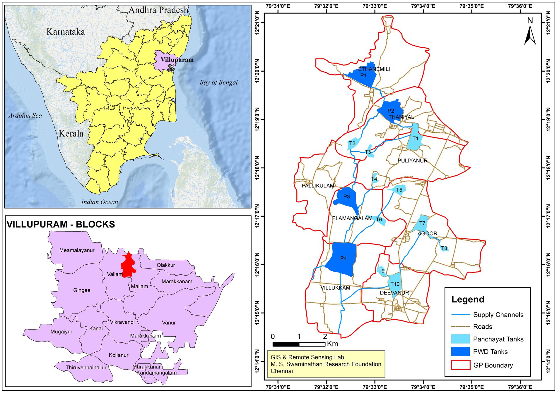
Figure 1. Location of the study area, Villupuram district in Tamil Nadu, India.
2.1.1 Selection of the tank cascade for the study
The tanks in the upstream catchment area of the Kazhuveli wetlands in Villupuram district of Tamil Nadu state (a Ramsar site and Bird Sanctuary, which is the second largest brackish lake in Peninsular India) are mapped initially, from which one cascade link consisting of 14 tanks (Figure 2) with a total geographical area of 4,882 ha in the Mailam block of the Villupuram district was taken for this study (Table 1). These tanks are located in one micro watershed and are interconnected to drain the excess water safely to the Kazhuveli lake. Of the 14 tanks, four are controlled by WRD and the remaining 10 by the RD, Government of Tamil Nadu, India. The four WRD tanks have WUAs, while the 10 RD tanks do not have such formal governance and management structures. The Government of Tamil Nadu enacted the Tamil Nadu Farmers Management of Irrigation Systems Act, 2000, and promoted WUA for WRD-managed tanks only. The primary function of the WUA is the management of the ayacut area, tank infrastructures, and ensuring equitable water distribution in the ayacut. The detailed profile of the tank status is given in Table 1. All are non-system tanks and receive water from rainfall.
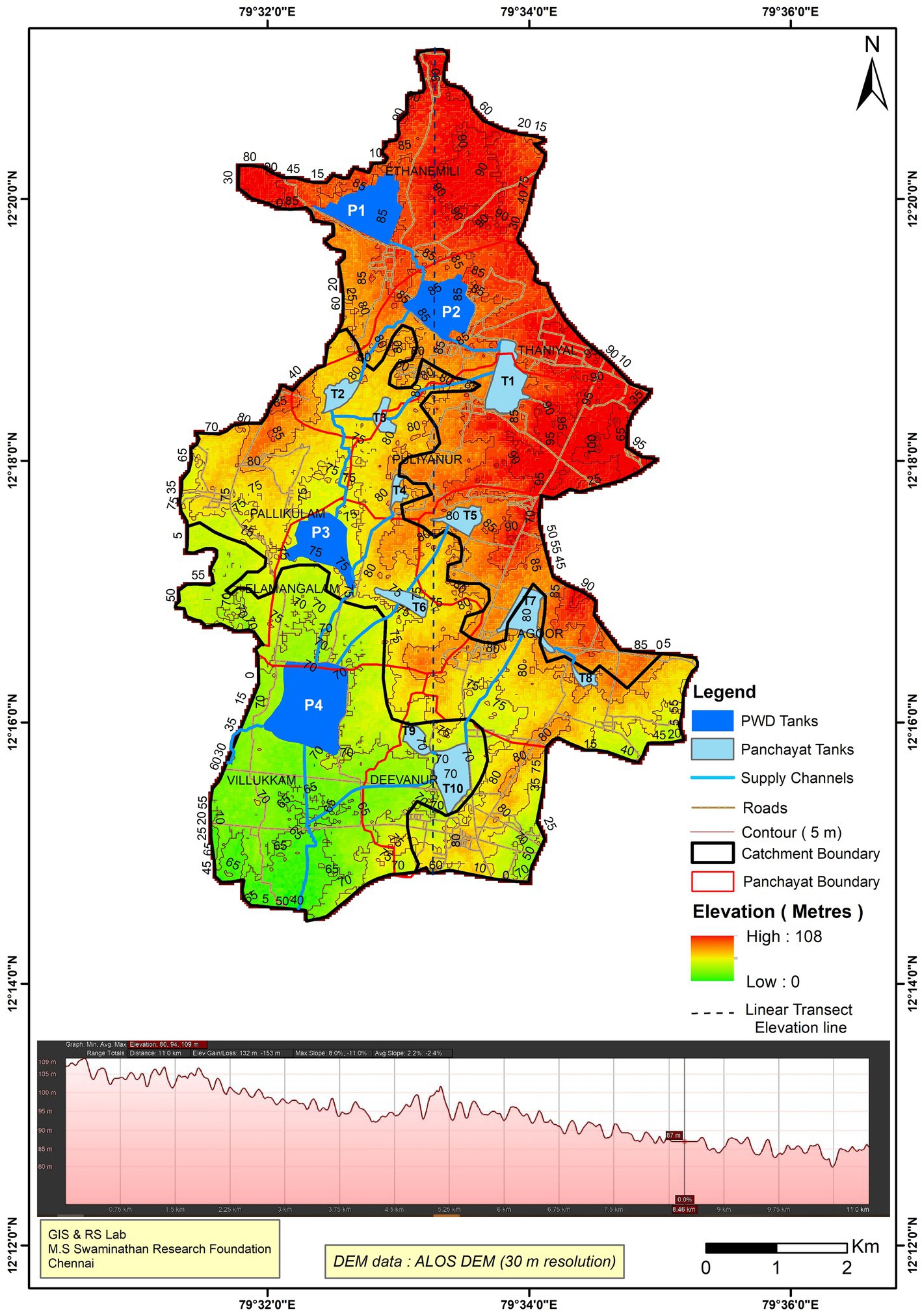
Figure 2. Structure of the Mailam tank cascade in catchment.
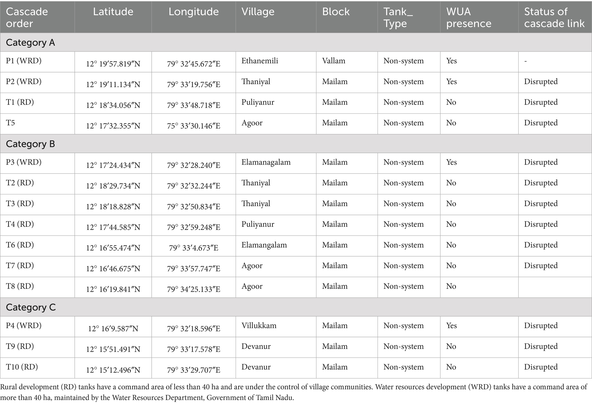
Table 1. General details of tanks and availability of irrigation functionaries in the study villages.
2.2 Data collection
The study adopted a mixed-methods approach to elicit data related to social and hydrological aspects and make it truly interdisciplinary research. The study adopted a socioeconomic and ethnographical data framework to understand the social part; transect walks, focus group discussions (FGDs), and key informant discussions were conducted (Table 2). The transect walk included members of government departments, leaders of local bodies, and members of the Water Users’ Association (WUA). Transect walks were conducted covering different points of the tanks, such as bunds, supply channels, encroached areas, the weir, outlets, irrigation channels, and agricultural fields. The transect walk provided multiple opportunities to listen, talk, and observe around the place. The walk over the entire tank bund provided an on-site visit to get an overview of the tanks, note ongoing activities and changes, discuss the diversity of issues related to irrigation and management of the tanks, and facilitate discussions about the drivers and the ways to address the issues. The method also helped to understand the current practices, technologies, and the changes that have occurred over a period of time. The transects were followed by FGDs to discuss and have an in-depth analysis of the transitions that occurred in farming and management practices, technologies, institutions, and the reconstruction of history, etc. The key informants, such as aged and experienced farmers, leaders, and members of the WUA, helped the research team to dive deep into traditional irrigation practices, social capital and community management, changes in cropping systems, tank conditions, and management practices. The changes in the area under tank irrigation (Census of India, 2001; Census of India, 2011a, 2011b), agricultural practices and cropping systems, and livelihoods were documented for one larger tank and one smaller tank in each of the categories as representatives to capture the shift for the study period 2004 to 2023–24.
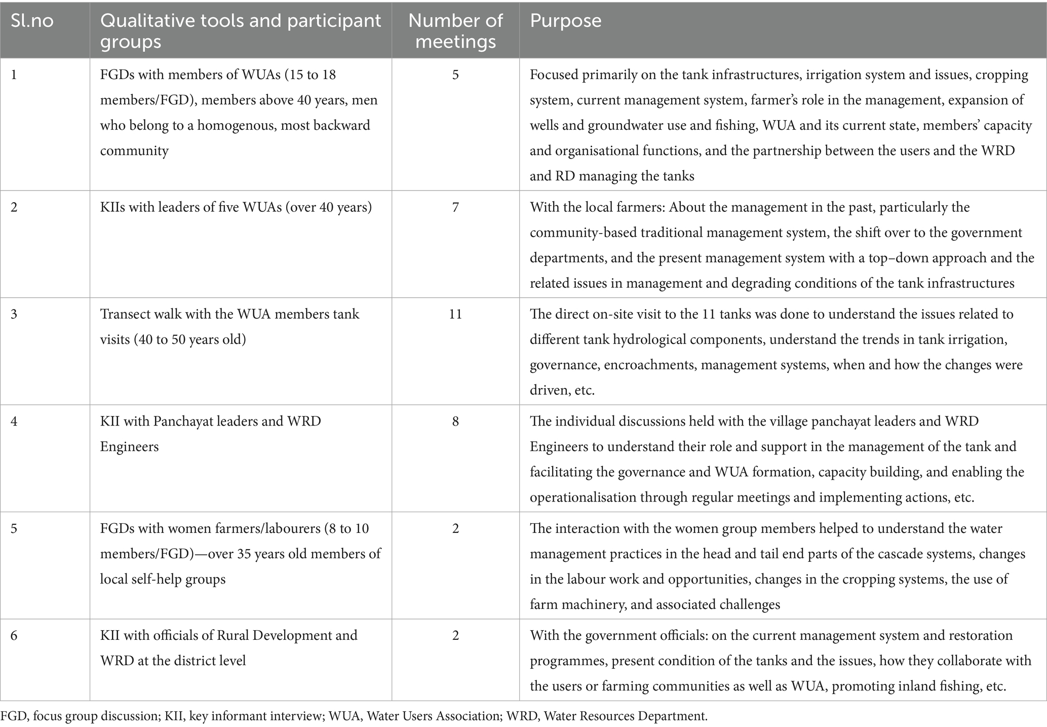
Table 2. Methods adopted, participant groups, and number of meetings.
2.3 Cropping systems, irrigation, and farmers
Agriculture is the primary livelihood of 75% of the population, with the net sown area of 45% (337,305 ha) of the total geographical area of the district (722,203 ha) and a high cropping intensity of 1.40. The small and marginal farmers are the dominant category in the district, accounting for 91% of the total farmers in the district (568,000). Paddy is the main crop cultivated across three seasons over 40% of the net sown area, followed by black gram, groundnut and sugarcane. There are 1,369 tanks in the district covering an ayacut area of 15,429 ha, in which more than 90% is under paddy cultivation in the Rabi season. For effective management of the tanks, the Government of Tamil Nadu enacted the Tamil Nadu Farmers Management of Irrigation Systems Act, 2000 and promoted WUA for WRD-managed tanks. The primary function of the WUA is the management of the ayacut area, tank infrastructures and ensuring equitable water distribution of water in the ayacut.
2.4 Rainfall
The gridded data for the Mailam block from 1994 to 2023, obtained from the Indian Meteorological Department’s LIB Python library (Pai et al., 2014), are used. The % departure was analysed by using the actual rainfall (1994–2023) to the long-term period average of 374 mm in SWM and 625 mm in NEM (1994–2023). The seasonal analysis also captured the number of rainy days in the respective seasons for both years. Besides, the heavy rainfall events were calculated under three categories based on the IMD’s standards as heavy rainfall (64.5 to 115.5 mm), very heavy rainfall (115.6 to 204.4 mm) and extremely heavy rainfall (equal to or more than 204.5 mm).
2.5 Land use and land cover
The Land Use Land Cover (LULC) map of the study area was generated using Remote Sensing-based satellite imagery (LISS IV) obtained from the ‘Bhuvan Bhoonidhi’ portal for the years 2004 and 2024. The spectral bands, spatial resolution, image ID, and acquisition date of the used data are given in Table 3. The supervised classification technique was adopted, and a random forest classifier was used to classify the satellite image to accurately classify various land uses across tank cascade catchments. This approach was vital, as land use types in proximity to tank systems play a significant role in influencing the degradation and hydrological functionality of tanks. The classification identified major land use classes, including croplands, fallow lands, other vegetation, settlements, and surface water bodies. The digitised water boundary and drainage line are overlaid on LULC. Due to the absence of detailed green cover data for the selected years, this study incorporated green cover into the broader categories of croplands and other vegetation during classification. The spatial extent of each land use type was calculated for both years to assess temporal changes in LULC, which was validated during the reconnaissance survey using the Global Positioning System. This enabled a comparative analysis to understand the implications of urban expansion and shifts in agricultural land cover on the ecological and hydrological functionality of the tank cascade system.
Table 3. Details of the spectral bands, spatial resolution, image ID, and acquisition date.
2.6 Surface runoff
The surface runoff was estimated using the strange method (Shanmugham and Kanagavalli, 2013), which is an empirical approach used to estimate surface runoff from rainfall based on predefined runoff coefficients for different catchment conditions such as total rainfall (mm), catchment characteristics including land use categories, and runoff coefficients (predefined % values for good, average, and bad catchments). This was estimated for the years 2004 and 2024 based on the area under four types of land use categories calculated from the LULC analysis for the study years.
2.7 Groundwater
The groundwater level data are obtained from the nearest monitoring wells of the Central Ground Water Board, in which water levels are regularly recorded four times a year during pre- and post-monsoon seasons. The data from two nearby monitoring wells—33,014 and 33,017 (Geo-coordinate: 12°15′03″79°34′46″ and 12°14′49″79°20′14″) were compared between 2004 and 2024 at pre- and post-monsoon levels. Also, the comparison of depth to water level of both pre- and post-monsoon 2024 with decadal mean pre- and post-monsoon covering the years from 2014 to 2023 was carried out.
3 Results
A detailed study of the current hydrological and sociological interaction systems, how they work with mutual feedback at different levels, contexts and effects was explored among the tanks in the cascade and local stakeholders.
3.1 Area under sources of irrigation and cropping system
There has been a significant difference in the area under sources of water for irrigation between 2001 and 2011 (Table 4). There has been a sharp decline in the area under tank irrigation in the overall area under irrigation. The next decadal data (2021) have not been released yet, but the area has been further reduced. It varies across tanks and ranges from 9 to 54%, till 2011, which has further declined over the last decade by over 70% (field observations). These negative changes in the area under tank irrigation have direct impacts on human water interactions by changing their dependency on tanks, which has implications for tank management and agriculture in the ayacut area. On the other hand, the area under open and bore wells has increased by more than 50%. Paddy is the main crop cultivated across two seasons in the past; however, with the wells, the intensity of cultivation has increased to three crops in a year.
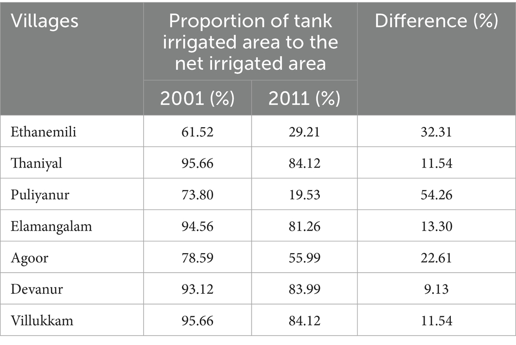
Table 4. Changes in the area under tank irrigated area to the net irrigated area between 2001 to 2011 in the study villages.
3.2 Conditions, infrastructures, and management of the tanks
This section details the status and condition of the tank infrastructures in the cascade. It also covers the condition of the hydrological components such as catchment area, foreshore, supply channel, water spread area, tank bunds, sluices, and surplus weirs. From the FGDs and transect walk, it is evident that the maintenance and management of the tanks and associated systems are in a poor state and degraded (Table 5). The bunds of all the WRD tanks are in very bad condition, with a narrow top surface and several gullies that are weakening them. Big trees with large roots on the inner surface of the tanks are altering the bund structures. In two tanks, the bunds are fully covered with trees and shrubs and completely block the way. Only in four panchayat union tanks are the bunds well maintained using local funds. Of the 14 tanks, only two have the sluices in working condition, and the rest of the tanks are almost dysfunctional; shutters are damaged/stolen, and the sluice is closed using sandbags and clay to stop the water flow (Figure 3). However, leakages were observed, leading to water loss.
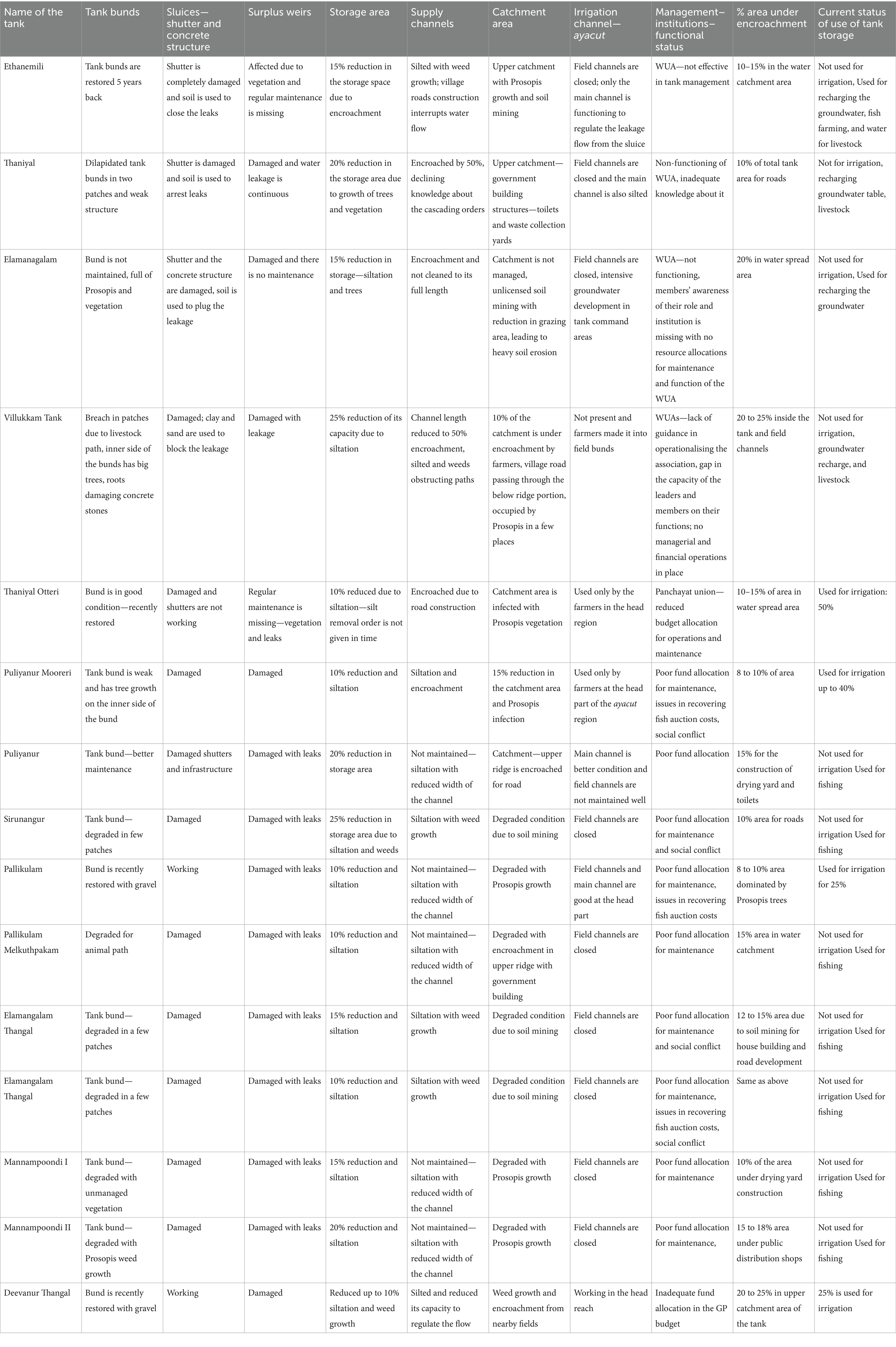
Table 5. Drivers of declining tank performance—condition of the tank infrastructures.
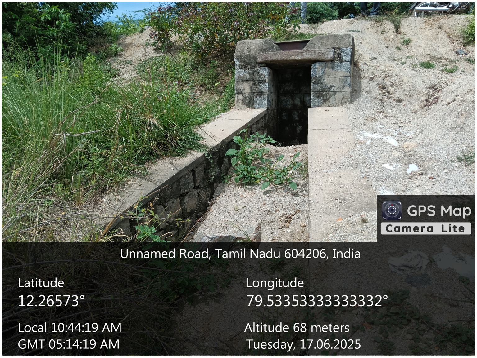
Figure 3. Closed sluices using soil.
The surplus weir is the facility provided to allow the flow of water beyond the storage capacity of the tank, causing damage to the weir and the flow of water instead of storing the expected quantity of water (Figure 4). In almost all the tanks, the surplus weirs are not given attention, and structures are damaged due to the roots of the vegetation, with five tanks being completely covered by the Prosopis species. The transect walk and interaction with WUA leaders pointed out that invariably in all the tanks, 10 to 25% of the storage area has been reduced, mainly due to siltation as well as due to the growth of weeds and other vegetation in the tank water spread area. The field data revealed that desiltation has not been carried out for more than a decade in all the tanks, which has significantly reduced storage capacity by up to 25%. The condition of supply channels is also poor due to a lack of maintenance, leading to siltation, weed growth, and disruption due to roads and encroachments. As per ownership, the bund area is under WRD or RD control, and the water spread area is under the control of the District Revenue Department. The key informant interview with the local panchayat leaders revealed that while removing encroachments in the water spread area, the District Revenue Department should be involved as a key stakeholder. Moreover, politically influential or well-off farmers are the main encroachers, and removing them is a political challenge, which was expressed by both WUA leaders and panchayat leaders during the transect walk and key informant interviews. For five of the RD tanks, there are no proper supply channels, and water is drained to the next tank in the lower gradient through agricultural fields, which was also evident during the transect walk to the tanks.
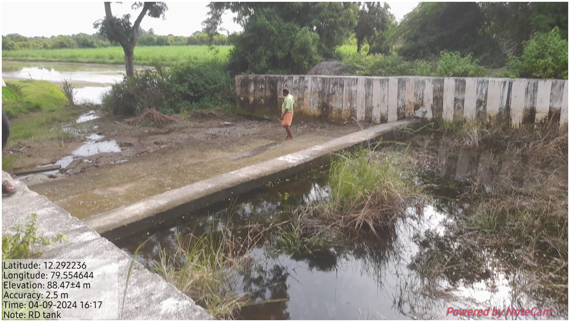
Figure 4. Leaking surplus weir.
The catchment area of all the tanks is also undergoing severe degradation. The main challenges are encroachment by the farmers, division due to a permanent village road without many drainage points, growth of Prosopis (an invasive deep-rooted tree species that grows quickly inside the tank), soil mining, construction of public utilities in the upper ridge, and degradation of grazing space. The boundary lines of the tanks were intact until the local communities managed the tanks. When management control was shifted to the government, encroachments by local farmers started, leading to a reduction in the water spread area. The control measures by the government system were inadequate to stop such malpractices. However, in the recent past, corrective measures have been put in place to address such issues. An example is from the TNIAM project launched in 2017–18, where protocols were evolved to demarcate the boundary mark, remove encroachments, and plant boundary stones. The field channels in the ayacut area play a critical role in safely guiding the flow of water from head to tail and support all the farmers equitably. However, except in three RD-managed tanks, the field channels were closed in the ayacut regions of the remaining tanks (Figure 5). This change is coupled with a steep increase in the use of groundwater through open or bore wells. In those three tanks, the field channels are maintained only in the head portion of the ayacut area.
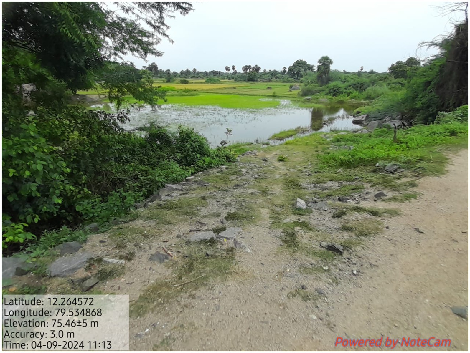
Figure 5. Disappeared field channels.
The governance and maintenance of the four tanks at the user level is through WUA, which is a formal body under the management of the Water Resources Department. However, on the ground, these WUAs are not effective and functional, and they lack the necessary capacity and knowledge to manage the tanks and water sharing. The WUA members themselves expressed the above gaps in the FGDs. In the remaining 10 tanks, which are under the control of the panchayat union, the inadequate allocation of financial resources for regular maintenance was the main factor for their degradation. The discussion with WUA members and panchayat leaders pointed out the lack of awareness of the members about the interconnected network of the tanks and their importance. However, further discussion with them in groups helped to understand that the presence of such knowledge and actions existed in the form of folk songs in the past. It was recalled by only old farmers who remember how systems existed, but the young and middle-aged farmers are not aware of such systems and networks. The current status of the use of these tanks was assessed through a transect walk with farmers, indicating that only three out of 14 tanks are used for irrigation, with up to 40%. The remaining tanks are primarily used as percolation tanks for groundwater recharge, for inland fishing, and for water for livestock. However, the leasing value of the fishing activity is also not effectively collected and put back into the tank management by the panchayats. The key informant interview with the panchayat leaders revealed that these tanks were captured by elite farmers in the six villages, and they independently do inland aquaculture with a negligible contribution to the village.
3.3 Traditional tank management and livelihoods
The variety and cropping systems have changed with the assured water access through groundwater, coupled with access to free electricity since 1990 in the state. In the transect walk and the FGDs, it became clear that there was a steep increase in wells from 20 to 80% in the ayacut area with the installation of electric pumps. This individual-centric access to water shifted farmers’ behaviour and dependence on the common water bodies for irrigation. Ultimately, the collective resource management approach in sharing water has disappeared, and farmers are losing interest in managing tanks collectively as they did in the past. The associated cultural practice of worshipping God before the first release of water and the community-managed system of water flow regulation has also become extinct and irrelevant in their cultural systems. This changing value system is again impacting the interconnection between the villagers and the tank system and its management practices. In the past, the irrigation tanks in the study region were traditionally managed by the local farmers for centuries. In the system, a local person called a Kombukatty is responsible for irrigating the fields daily. The tank had one or more than one person, depending on the size and number of main irrigation canals. His job is to irrigate all fields and maintain the sluices. For this, he was rewarded in kind, roughly 100 kg of paddy grains for one acre of paddy field. He was traditionally from the Scheduled Caste community and could work day and night, dealing with a group of farmers/owners of the fields. Now, people from the Scheduled Caste are not interested in taking up the work anymore, and there is no interdependent relationship between farmers and labourers.
The long-duration traditional paddy varieties were replaced with short and medium-duration, high-yielding varieties, leading to the intensification of the cropping system from one to two or three crops in a year. The change has been supported by the use of farm machinery services for land preparation and harvesting. These changes have displaced agricultural wage labourers who depend on local employment (Table 6). Mostly, men migrated to urban centres for non-farm employment, while women stayed back and primarily engaged in the Mahatma Gandhi National Rural Employment Guarantee Scheme of the government and managed small-scale agriculture. These changing socio-economic contexts are also contributing to the change in the functional use of tanks as a groundwater recharge structure to recharge the groundwater rather than as a resource for irrigation.
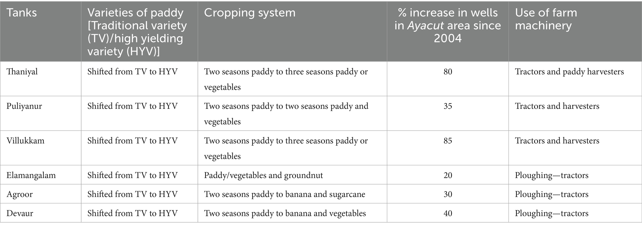
Table 6. Changes in the agricultural practices from 2004 to 2023–24.
3.4 Rainfall analysis
The availability of water in all tanks in the cascade over seasons is entirely dependent on rainfall. The analysis indicates that NEM contributes 54% of the total annual rainfall, followed by 36% in the SWM (Table 7). Between 1994 and 2023, annual rainfall in the region displayed significant variability, with multiple years receiving far below or well above the normal of 1,103 mm. Notably, 2002 and 2003 were extreme drought years with annual rainfall as low as 66 mm and 112 mm, respectively (Figures 6a,b). Among the two seasons, the % departure from normal rainfall was higher in SWM compared to NEM. From 1994 to 2023, both SWM and NEM showed high variability in rainfall and deviation from normal seasonal rainfall (Figures 6c,d). Severe deficits occurred in the early 2000s, especially in 2002 and 2003, when both monsoons received less than 10% of their normal rainfall. The years 2005, 2008, and 2021 saw significant NEM surpluses, while SWM showed excess rainfall in years like 2011, 2013, and 2023.
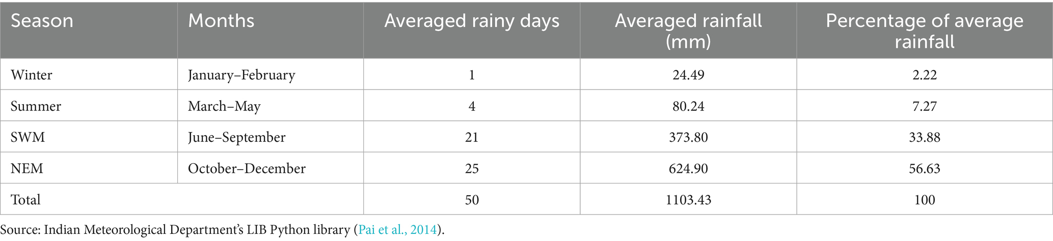
Table 7. Seasonal analysis of rainfall (mm) in Mailam block, Villupuram district, Tamil Nadu (1994–2023).
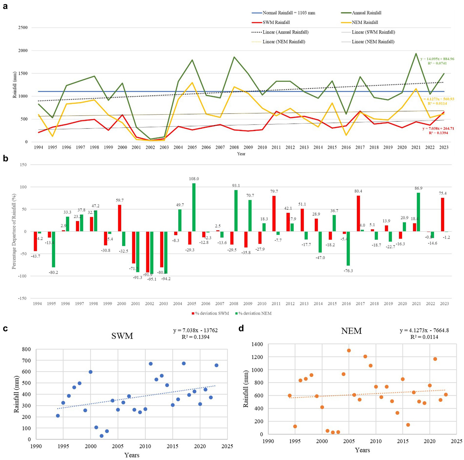
Figure 6. (a) Trend of annual rainfall and seasonal variations SWM and NEM (1994 to 2023). (b) Percentage departure of SWM and NEM from long period average. (c) Scatterplot SWM from 1994 to 2023. (d) Scatterplot NEM from 1994 to 2023.
Besides the seasonal shifts, between 1994 and 2023, a total of 63 heavy rainfall events, 15 very heavy rainfall events, and 3 extreme heavy rainfall events were recorded (Figures 7a,b). Before the year 2000, only heavy and very heavy rainfall events were observed, with no extreme events reported. However, from the 2000s onward, all three categories began to occur more frequently, reflecting a shift in rainfall intensity patterns. Years like 2008 and 2021 stand out, as they recorded all three rainfall events, indicating an increasing variability and intensification of extreme weather events. The year 2017 witnessed the highest number of heavy rainfall days (5), whereas 2005 and 2008 experienced the highest total rainfall amounts, highlighting a trend of intensifying and localised extreme rainfall events in recent decades. The data indicate increasing rainfall extremes and seasonal unpredictability, suggesting a shift in monsoon patterns over the decades. Overall, the data suggest a trend of increasing rainfall extremes, both deficient and excessive, highlighting the growing climatic variability in monsoon behaviour, which has implications for tank-based irrigation and infrastructure management, and its hydrological parameters.
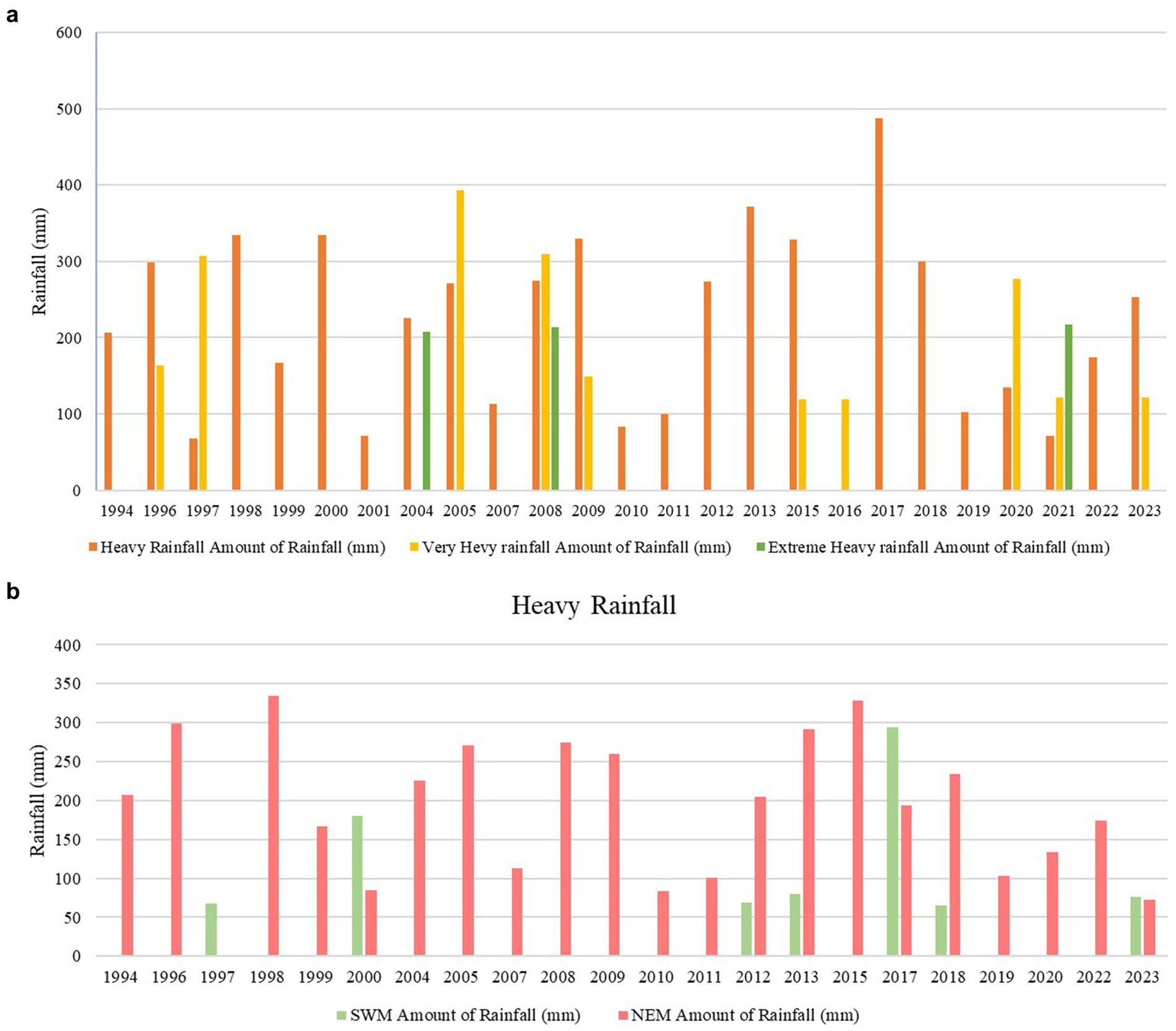
Figure 7. (a) Heavy rainfall events during 1994 to 2023. (b) Season wise heavy rainfall events from 1994 to 2023.
3.5 Land use changes
The land-use and land cover analysis between 2004 and 2024 showed that cropland was the dominant category, with a 44% reduction, covering approximately 1,707 ha in 2004 and 954 ha in 2024 (Figures 8a,b). In the fallow land category, it increased from 1,607 ha in 2004 to 1,822 ha (13% increase). The other vegetation, including trees and natural cover, accounted for 1,118 ha in 2004 and increased to 1,596 ha in 2024 (43% increase), with a spike in built-up area from 5 ha to 60 ha (Table 8). The changes in area under cropping, fallow land, and other vegetation point to the changes in the dependency on tanks for irrigation. In built-up areas, which are land other than agricultural use, there has been a significant increase in area, which has direct implications for surface runoff.
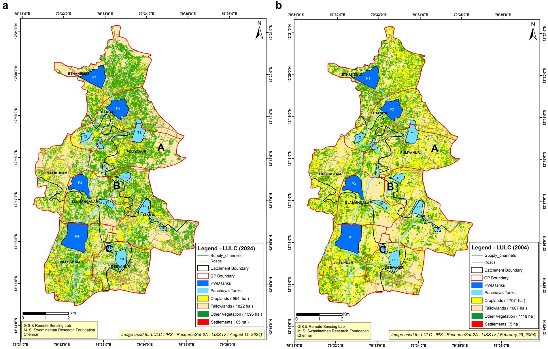
Figure 8. (a) Land use and land cover of the Mailam cascade system—2004. (b) Land use and land cover of the Mailam cascade system—2024.
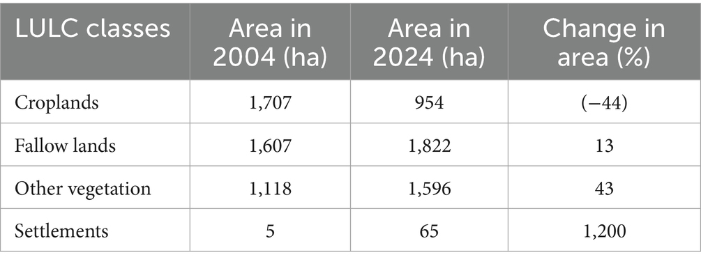
Table 8. Changes in area between the years 2004 and 2024 for catchment areas.
3.6 Surface runoff
The surface runoff from the upper catchment is higher compared to the middle and lower catchment categories. At the overall level, based on the LULC categories, there is an increase of 19% in surface runoff between 2004 and 2024 (Table 9). The surface runoff has increased due to the changes in the LULC categories, as well as an increase in the annual rainfall compared to 2004.
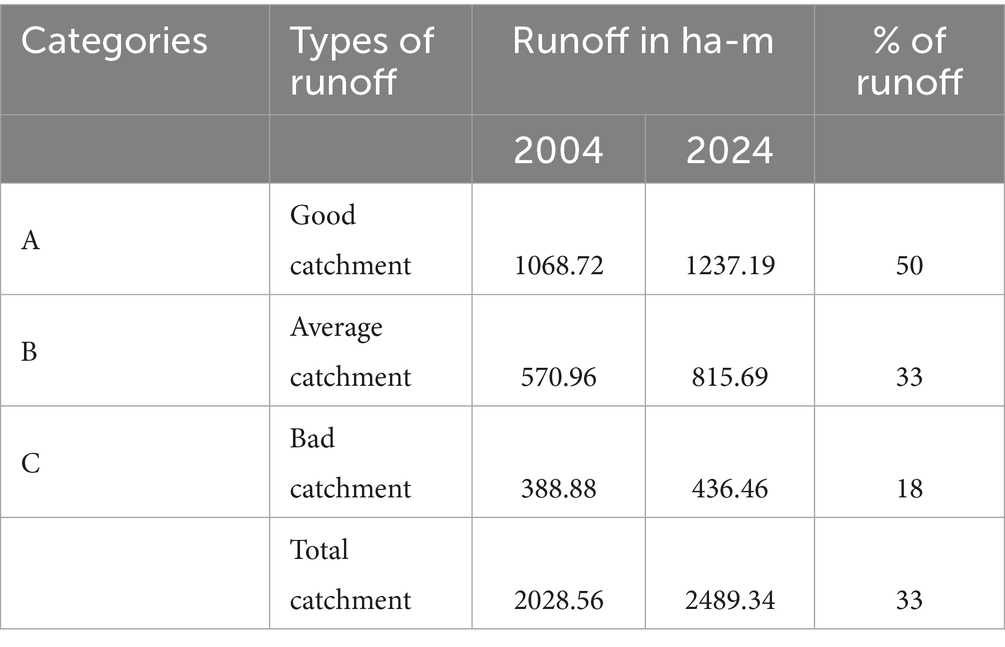
Table 9. Changes in the runoff from different catchments.
3.7 Groundwater
The fluctuation of groundwater level between pre- and post-monsoon for the years 2004 and 2024 shows a fall in levels from 0.03 to 0.73 m below ground level (bgl). The decadal mean comparison (2014–23) with 2024 at both pre- and post-monsoon periods shows a steep fall in water level of 0.43 to 0.82 m bgl (Table 10). This coincides with the increased number of wells and the increased use of wells for irrigation.
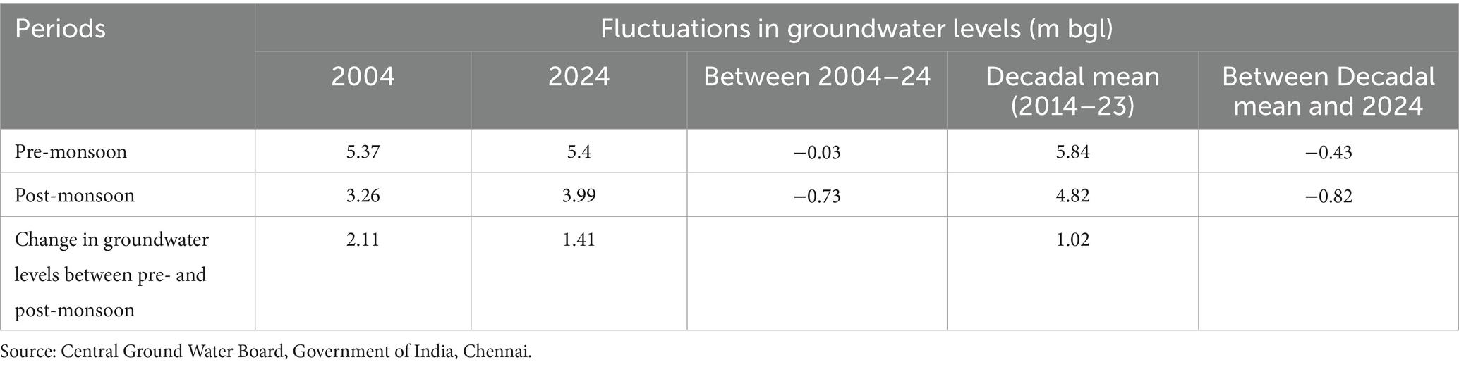
Table 10. Groundwater level in pre- and post-monsoon seasons between 2004–24.
4 Discussion
The surface water tanks are largely linked to each other in a cascade, which regulates the overflow from upstream tanks through supply channels to the tanks downstream. In the dryland regions of South India, the cascading systems were important adaptation solutions for farmers to build resilience against frequent droughts (Srivastava and Chinnasamy, 2021). Such systems have been traditionally developed with intersecting rules and regulations to manage the hydrological and social components effectively and serve as the best example of socio-hydrological systems (Prakash et al., 2025; Jain et al., 2024; Bhuyan and Deka, 2024). This has been documented as Mamulnama over 200 years ago, based on experiential knowledge (Sivasubramaniyan, 2019). It served as a tank water management guide, developed when Mirasi tenure systems were in practice in South India. Besides the management of the irrigation infrastructures, the delivery of water to the fields for irrigation with fairness, transparency and equity was governed by a collective system in an inclusive framework. However, this has not been revised in alignment with changes in the land holding pattern, agrarian structures and tank management systems. Currently, the structure and the related knowledge on the cascade systems and tank management have been undergoing degradation with the shift in farmers’ behaviour on the use of groundwater resources (Mosse, 1999; Sakthivadivel et al., 2004; Srivastava and Chinnasamy, 2023). The key drivers of degradation, namely changes in the socio-economic, LULC and agro-ecological environment, and agricultural intensification, weakened the tank cascade system, which was also reported in Sri Lanka, recognised as Globally Important Agricultural Heritage Systems (Jayanesa and Selker, 2004; Wickramasinghe et al., 2022). Among several drivers, negative changes in the governance processes made them most vulnerable to degradation (Bebermeier et al., 2017; Ratnayake et al., 2024) and also changing gender roles in farming. Most importantly, the changing governance system from the traditional to a government-mediated system and the gaps in operationalising the WUAs’ functions and processes result in socio-political issues, namely power dynamics, political and social factors in accessing water resources and shaping water-related interactions and conflicts both within the village and at the cascade level (Döring et al., 2024).
Besides, the feedback loop between water and farmers’ (human) systems, a core dimension of socio-hydrology in this study, reveals the ongoing challenges at the local level, coupled with increasing climate extreme events. The following sections explain the challenging feedback loops.
4.1 Impacts of the changing hydrological components
A comprehensive understanding of the key drivers of social, hydrological, as well as other social and environmental dimensions is crucial in tank management (Palanisami, 2006; Glendenning et al., 2012). The hydrological components of key tank infrastructures are undergoing severe degradation in the Mailam tank cascade due to socio-economic, institutional, and political drivers that have eventually shifted the primary functional use of the tanks. At the same time, changes and variations in rainfall across seasons, surface runoff, and LULC changes have been noted in the systems and farmers’ behaviour. Cumulatively, these changes were observed at the cascade level, command/ayacut area level, and at the community level. The reduction in storage capacity of the tanks, dysfunctional sluices, encroachments in supply channels and catchment areas, and dismantling of field channels are the key hydrological drivers for poor tank management and water control (Palanisami, 2006; Kajisa et al., 2007; Ratnayake et al., 2024).
The notable change is the declining trend of net irrigated area under tank-based irrigation in study villages and a shift in the purpose of water storage from irrigation to groundwater recharge services (Mosse, 1999; Shah, 2008; Narayanamoorthy, 2007; Palanisami, 2022). A similar trend in sharp decline from 12 to 2% between 1973 and 2018 at the all-India level was reported by Palanisami (2022). This trajectory is directly linked to the decreasing viability of farming based on tank irrigation. The key drivers of this change are siltation of the tank and reduction in storage capacity, encroachment in catchment and supply channels, change in cropping systems, increase in groundwater wells in the command area (Mosse, 1999; Kajisa et al., 2007; Palanisami, 2022), change in tank management (Sivasubramaniyan, 2019), and changes in farmers’ behaviour due to the disappearance of the traditional murai system and eroding social capital among the ayakatuthar groups.
Of the multiple drivers of change, the water storage capacity of the tank is the primary one, and a reduction in the storage capacity of up to 25%, as noted in these tanks, was mainly due to a lack of timely policy support, allocation of resources, and the disappearance of traditional village-based management systems (Palanisami and Meinzen-Dick, 2001; Amarasinghe et al., 2009). Traditionally, they desilt tanks adopting Kudimaramathu in the summer season; however, now government regulations are not allowing them to remove silt from tank beds at the right time. Besides the reduction in water storage, the lack of access to silt from the tank for farmers affects soil fertility and indirectly impacts crop productivity and farmers’ livelihoods. But in 2023, permission was given by the government after the onset of the first monsoon, and by that time, water was at more than 50% capacity (Government of Tamil Nadu, 2024); hence, it was not useful for farmers. The desilting of the tanks is also linked to the management of vegetation, especially the invasion of Prosopis trees and other wild species within the tanks. These factors cumulatively reduced the water storage capacity of the tanks.
The changes in tank management are also closely linked to changes in cropping systems, increasing reliance on groundwater, and a number of open/bore wells in the ayacut regions. In the ayacut area, individualised behavioural actions on the collective irrigation method led to the degradation of field channels in almost 90% of tank ayacut areas. This altered the flow of excess runoff from fields at the time of high rainfall and affected crop cultivation by farmers whose land parcels are in the interior and tail end of the ayacut. It was evident from the increasing proportion of fallow lands and other vegetation (13% fallow land and 43% other vegetation) over the last two decades, with a decline in cropped area to an extent of 44%. This negative trajectory was part of the weakening of the tank-based institutions, poor governance at the operational management level, and the absence of a conflict-resolving mechanism in both catchments and ayacut areas.
The other most impactful hydrology-linked changes are an increasing trend in averaged rainfall and its distribution, changes in the LULC categories, and an increasing trend of surface runoff (19%). These changes, coupled with disappearing tank maintenance systems, have a deeper impact on tank infrastructure-related risks to the community. The interlinkage of tanks with downstream (cascade) systems is increasingly critical in the context of extreme rainfall events and floods (Palanisami, 2022). The predictions of the IPCC (2021) point out the probability of an increasing number of extreme rainfall events. In this study, it is observed that there has been an increase in heavy rainfall, very heavy rainfall, and extremely heavy rainfall since 2000, especially in the NEM season. In this backdrop, the poor maintenance of bunds, shutters, and sluices makes members of the WUA worry about safety during the rainy season, especially when the tank reaches its full storage (while it is not used for irrigation and sluices are defunct). They also remember the past events of breaches, loss, and damage to crops and assets. They also reported that when the community was managing the tanks, they pruned the trees and annually cleaned and strengthened the bunds as well as the sluices. The leaves of the trees were used as green manure in the paddy fields in the existing systems; however, now in the new system, such tank management practices are not permitted, especially in WRD-managed tanks. This trend has changed the farmers’ behaviour in RD tank management as well. This shift triggered the decline in collective action and alienation from managing the common property resources and their use (Palanisami and Balasubramanian, 1998; Sakurai and Palanisami, 2001; Kajisa et al., 2007).
The dysfunctional shutters and sluices are the next important infrastructures that impacted the regulation of the irrigation system in the ayacut. It led to unreliability in obtaining water for irrigation. Two of the WRD tanks were renovated during the last 5 years, but there is still continuous leakage in the sluices, resulting in water being drained continuously and impacting storage. A similar issue was reported by Steiff (2016), who studied water storage and release dynamics of the Thirumalsamudram cascade, Guntur basin in Tamil Nadu, and reported that sluice outflow was the highest part of the water budget, ranging from 19 to 55%, with 15 to 50% of the outflow not being utilised (Van Meter et al., 2016). The farmers with access to wells manage to irrigate their fields; however, marginalised farmers without wells and those in the tail end are the affected ones. Sometimes, when the water level reaches its full capacity, farmers in the upper catchment area, particularly those with crops in the encroached tank bed area, open the sluices or damage weirs to avoid the submergence of their lands and standing crops.
Besides, inflow to the tanks has been significantly reduced in many tanks, and encroachment is an important issue noted in the catchment area and supply channels (Palanisami, 2022). This has adversely impacted the link between the tanks and is affecting water flow from upstream to downstream, ultimately degrading the cascade structure. The studies of Palanisami (2022) and Chinnasamy and Srivastava (2021) also reported it as a serious structural concern in tank rehabilitation and recommended mainstreaming the cascading approach in the policy. The encroachment is both from local farmers and government sources. Apart from individual farmers’ encroachment, the tank area is used for common infrastructure for the village, such as roads, public toilets, drying yards, waste segregation units, etc., by the government. However, the failure to address such a problem of encroachment and regulate the flow is mainly due to a lack of interest and coordination from the WRD and RD to facilitate with the district revenue department, and the alienated feeling of the leaders of WUA and ayacut farmers. Here, the revenue department plays an important role in demarcating the boundaries to avoid encroachments and putting boundary stones to make the tank boundaries visible. The problem also has a social dimension; the encroachers are from the same kin groups or people with political support, which prevents the WUA leaders (who are not active in most cases) and other active farmers from taking disciplinary actions on the ground. Another emerging issue is a lack of information and traditional knowledge on the drainage, supply channels, and interconnecting tank systems among the young and middle-aged farmers.
4.2 Changes in the social dimension of tank management and resources
The underperformance of the tank-based institutions and their governance is another important interlinked driver for the declining tank irrigation system. It has adverse impacts on key functions including “water acquisition, water allocation and distribution, maintenance, decision making, enforcement of decisions and conflict resolution” (Palanisami, 2022). In the age-old traditional management, tanks were managed by networks of all ayacut farmers with trust, collective ownership, and contributions to decision making (Sivasubramaniyan, 2019). The system had a well-defined monitoring system and clarity on roles and responsibilities for different players, including farmer contributions for the maintenance and management embedded in the power relations of social and economic dimensions. Several studies have recorded the close link between the declining tank irrigation and people’s collective action in its management (Sakthivadivel et al., 2004; Palanisami, 2006; Palanisami, 2009; Sivasubramaniyan, 2006; Reddy, 2015). Palanisami (2022, p. 9) narrated the changes in the traditional management system as “the cumulative effect of the policy and institutional neglect.”
A change in policy began when the ryotwari system was introduced in 1886 by the British colonial government; a drastic change was made in the management of the tanks, with larger tanks (40 ha and above) under the WRD and other tanks (less than 40 ha) under the RD. Since colonial rule, there have been changes in the land revenue systems, which led to a shift in the ownership and management of the tanks to the government (Vani, 1997; Agarwal and Narain, 1997; Mosse, 1998). Before that, local community-based institutions were managing the tank resources and irrigation systems. Subsequently, with the enactment of the Tamil Nadu Land Encroachment Act 1905, complete ownership and control of the water bodies were shifted to the government (Gurunathan and Shanmugam, 2006; Saravanan, 2017). These departments managed the tanks adopting a top–down approach with technically qualified engineers, which gradually disempowered the local community and the self-evolved community-based management system. Notably, maintenance of the tank infrastructure was based on the allocation of funds from the government and implemented in the field without farmers’ or users’ participation. The WUA was formed in two WRD tanks in the cascade through the TNIAMP tank restoration programmes; however, it still functions in a top–down manner, and the association does not have the capacity and necessary resources to plan and execute the management actions.
As per the new system, WUAs are formed at the village level; however, they do not have the required capacity to manage the tanks, regulate the irrigation systems, and facilitate human–water interactions. Also, there is no discussion or arrangements to integrate the cascading principles in the scope of work (Palanisami, 2022). The interaction with them revealed that there is a lack of clarity regarding their roles and responsibilities, decision-making power, and required knowledge of the Mailam tank cascade system. The WUA membership has never created a network or trust among the members, nor have there been discussions among the village leaders to share knowledge and make decisions within the cascade system. The capacity of the WUA, as a tank management institution, was inadequate at the ground level to handle the complex issues and challenges in management and governance, as they are closely linked to their social systems. Furthermore, no such institutional systems were formed for the RD tanks; instead, the responsibility was given to the village panchayat. The changes in the policy and management practices of irrigation tanks and the rehabilitation framework led to disruptions in the other socio-environmental co-benefits, namely groundwater recharge, flood flow management, management of drought, community ownership and collective action in tank resource maintenance, and cascading structures, and adversely impacted the interconnections of hydrological, ecological, and social systems (Nüsser et al., 2012; Nüsser et al., 2019; Sivapalan et al., 2012; Xia et al., 2022; Palanisami, 2022). The engagement and monitoring of the WUA’s activities from the department were also limited and insufficient to empower them to act dynamically. This is coupled with a lack of proper and effective communication between the WUA and the government departments, which could extend support for managing the tanks. Such an arrangement led to the complete alienation of farmers from the management system, and their traditional knowledge was ignored and never used for tank management. However, before 1886, when the system was managed by ayacut farmers with customary rights, it was continuously monitored and managed based on experiences in a decentralised manner (Saravanan, 2017).
Traditionally, tank irrigation flow was under the control of village management, which appointed a specialised person, as discussed above, who was responsible for irrigation scheduling to all the fields, till the tail end, besides maintaining the irrigation channels and sluices. Such locally managed systems had strong human–water interactions and interconnectedness. However, a change in the management system disrupted regular repair and renovation practices, changed the practice of ownership from collective to individual farmer level, and resulted in growing inequalities in accessing water for irrigation. It also affected irrigation practices and the maintenance of the infrastructure, including irrigation channels and sluices. The size of the field channels was reduced or completely removed, which affected the tail-end farmers. Damaged sluices were either completely closed or, due to damage, allowed water to flow continuously, draining the water in the tank. However, the WRD attends to repair work only when funds are available. The community’s behaviour of worshipping the tank and cultural practices before the first release of water during the cropping season has almost disappeared in all the villages (Ganesan, 2008). Regarding the increasing practice of well irrigation, in 2004, tank-based irrigation was followed, and primarily, farmers cultivated two crops in a year. Paddy was the first crop in all fields, and the second crop was either paddy or vegetables/pulses. At that time, only a few wells were owned by rich farmers, and they cultivated a third crop. However, in 2024, two to three crops of paddy are widely cultivated by the farmers who have access to individual wells.
The well intensity has increased from 20 to 85%. Besides access to groundwater, the use of technologies such as medium-duration varieties, farm machinery for land preparation, harvest and post-harvest processing, to cope with labour scarcity, and chemical fertilisers have enabled farmers to adopt crop intensification. In the changing context, farmers now face difficulty in carrying out different agricultural practices individually; for example, ploughing and planting need to be planned as an entire cluster to regulate the mobility of tractors and reach all the fields. Otherwise, fields located inside the ayacut could not be cultivated, leading to an increasing proportion of fallow land. Farmers remember that in the past, when they had the traditional management system, all the ayacut farmers made a collective plan to carry out different activities, and now this is not followed. This shows the declining status of social capital and collective actions (Fukuyama, 1995; Mosse, 1999). Shortages of labour, farm mechanisation, and an increase in the cost of cultivation have made agriculture a non-profitable enterprise, and farmers are losing interest in continuing agriculture.
The plantation of Acacia in the foreshore area of the tank under the social forestry scheme started in 1981, invariably damaging the storage area. The tree felling plan was not designed well, which led to aggressive growth along with the invasion of Prosopis species over the bunds and storage area, affecting the maintenance of the tanks (Figure 9). There is a wide gap in understanding between the WRD, RD, and the Forest Department. The WUA was never consulted, as already indicated; due to a lack of a proper felling plan, well-grown trees are still occupying the storage areas of the tanks along with the invasion of the Prosopis species. Similarly, the removal of the encroachments in the water spread area and supply channel, and demarcating the boundary line is another long-pending issue, which requires active participation and support from the WRD, RD, District Revenue Department, and the leaders of the WUA. Restoring the supply channel is farmers’ first priority in tank management. Boundary demarcation and planting of boundary stones were included in the scope of the work of the TNIAM scheme and implemented in the field. A similar effort needs to be carried out for the rest of the tanks.
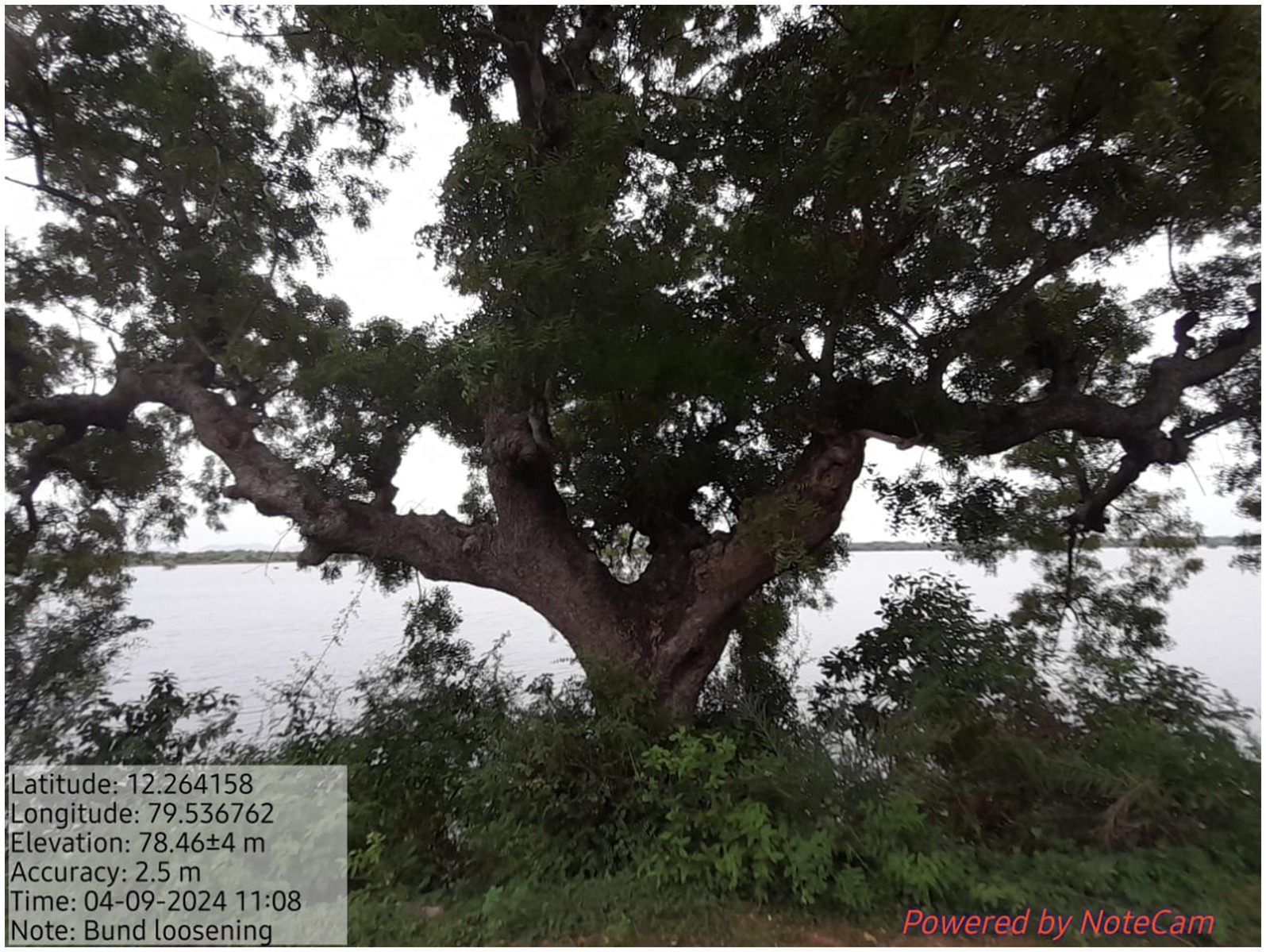
Figure 9. Growth of a Huge tree—weakening the tank bund.
Besides, changes in the rainfall pattern, fluctuations in the tank hydrological components, farmers’ behaviour in use and management, and the disappearing cultural connection with tanks are imperative drivers. In this backdrop, the traditional approach of restoring a single tank is inadequate in reducing the risks and building resilience. As mentioned above, the interdisciplinary framework in tank rehabilitation connecting hydrology, water, and users (farmers in this case) and a systems approach (tank cascade) is crucial (Sivapalan et al., 2012). Such a holistic approach is not well integrated into the tank restoration policy. The ongoing major scheme, TNIAM, has restored over 4,778 WRD tanks covering 66 sub-basins, leaving the interconnected RD tanks. This disruption in the connection leads to flooding of fields and habitations, and affects the hydrological components of the tanks.
Finally, for the effective functioning of WUA, which connects water resources/tank infrastructures and farmers, it needs a strong financial base for its tank maintenance; however, currently, there is no source to mobilise it. The potential local strategy of promoting fish culture is one of the feasible options that involves less labour, risk, and management but has good potential to provide revenue every year to WUA. The WRD or RD can arrange for cross-learning from the Ayakatuthars, who manage successful fish culture. As indicated above, social capital was the fulcrum in the traditional water management system, but in the present condition, many changes have taken place, including the primary objective, such as field irrigation systems and agrarian relations. Generally, social capital works well in a situation where systems are developed to address the common objectives of group members; in such cases, activities like fish culture and similar economic activities can be identified and promoted, which can strengthen the bond and trust among the water users through the sharing of responsibilities.
5 Conclusion
The current water crisis being faced by humans and the environment, particularly in surface water bodies, is largely attributed to changes in hydrology and human interactions owing to poor management of tank infrastructures, inadequate knowledge of tank cascades, a shift to motorised well-based groundwater for irrigation, changing cropping systems, a shift in the institutional and governance approach, declining community roles, and the lack of resources and effective coordination among key stakeholders. In this study, it is evident that there have been changes in the functional values of tanks from irrigation to groundwater recharge and inland fishing, which have notable implications for the management of tanks, interconnecting tank flows, storage, and their hydrology by farmers. Climate change predictions further compound the impacts, as there has been an increase in extreme events of precipitation regimes, which have larger consequences for the hydrology of the tanks in their current state.
In such a complex context, the framework of socio-hydrology supports a holistic analysis by integrating complex feedback loops in use and co-evolved interdependencies between farmers and water systems.
In the context of changing farmers’ behaviour from community-based surface water to individualised groundwater-based irrigation, chronicling knowledge of the tank cascades and raising awareness are crucial in building resilience. The understanding of system-based tank management and human interactions with water resources is currently inadequate to meet the challenges of future climate risks. This study can be further expanded and deepened with a scale-sensitive, socio-hydrological modelling framework to predict tank resilience under changing climate, agriculture, and human scenarios and recommend ecosystem-based adaptation solutions.
The policy initiative of the state government advocates a bottom–up participatory approach in tank management; however, when the policy is translated into action, a top–down approach is practised. The department operates with a centralised planning and monitoring system; hence, an inherent hurdle exists to promote a participatory approach, empowering the farmers and strengthening the WUA governance and leadership. Moreover, the tank management policy is so far limited to treating the tanks as individual structures, leaving the interconnected smaller tanks in the landscape at the design and planning stage itself, in spite of their hydrological interlinks. Here, the traditional knowledge of local farmers on tank-specific and cascade-level needs to be effectively used in designing the programme and co-management strategies. Another important factor is that trust among the WUAs and between government agencies and the water users is a key factor in building a resilient self-governing institution. Besides, although conventionally, water and irrigation management are largely a man’s role, in the context of changing women’s roles in agriculture while men are migrating to the non-farm sector, there is an opportunity to harness women’s collective power in tank management. In the recent past, there has been a growing interest among large financial institutions, corporations and industries to invest in tank rehabilitation programmes. A comprehensive system-based tank rehabilitation policy framework integrating hydrological and social dimensions is a priority to harness development finance effectively for long-term, sustainable and resilient actions in reviving tank systems.
Data availability statement
The original contributions presented in the study are included in the article/supplementary material, further inquiries can be directed to the corresponding author.
Author contributions
RR: Conceptualization, Data curation, Formal analysis, Investigation, Methodology, Supervision, Validation, Writing – original draft, Writing – review & editing. PT: Conceptualization, Investigation, Methodology, Writing – review & editing, Data curation, Formal analysis, Validation. RN: Data curation, Methodology, Writing – review & editing. PN: Writing – review & editing.
Funding
The author(s) declare that no financial support was received for the research and/or publication of this article.
Acknowledgments
The authors thank the support extended by the Central Ground Water Board, Chennai, and the Water Resources Department, Villupuram, for getting the necessary data sets related to groundwater and tanks. The technical support of Dr. Ugalechmi, Ms. Yogalakshmi, Mr. Rubesh, and Mr. Balasubramanian, MSSRF, is duly acknowledged in data curation. The authors are grateful to the men and women farmers, WUA, and leaders of the Panchayat Union for their kind cooperation and for engaging in discussions and field visits with our team.
Conflict of interest
The authors declare that the research was conducted in the absence of any commercial or financial relationships that could be construed as a potential conflict of interest.
Generative AI statement
The authors declare that no Gen AI was used in the creation of this manuscript.
Any alternative text (alt text) provided alongside figures in this article has been generated by Frontiers with the support of artificial intelligence and reasonable efforts have been made to ensure accuracy, including review by the authors wherever possible. If you identify any issues, please contact us.
Publisher’s note
All claims expressed in this article are solely those of the authors and do not necessarily represent those of their affiliated organizations, or those of the publisher, the editors and the reviewers. Any product that may be evaluated in this article, or claim that may be made by its manufacturer, is not guaranteed or endorsed by the publisher.
Supplementary material
The Supplementary material for this article can be found online at: https://www.frontiersin.org/articles/10.3389/frwa.2025.1597293/full#supplementary-material
Footnotes
1. ^Chapter 4.1.9 Groundwater resources, Villupuram district https://nwm.gov.in/sites/default/files/Notes%20on%20Villupuram%20District.pdf
References
Agarwal, A., and Narain, S. (1997). Dying wisdom: Rise and fall of India’s traditional water harvesting system. New Delhi: Centre for Science and Environment.
Agrawal, T., Pompoes, R., Verzijl, A., Srinivasan, V., Nair, J., Huijbens, E., et al. (2024). Creating Kaveri delta beneath our feet. An experiment in grounding socio-hydrology in Tamil Nadu. J. Hydrol. 644:131896. doi: 10.1016/j.jhydrol.2024.131896
Alcamo, J., Florke, M., and Marker, M. (2007). Future long-term changes in global water resources driven by socio-economic and climatic changes. Hydrol. Sci. J. 52, 247–275. doi: 10.1623/hysj.52.2.247
Amarasinghe, U. A., Singh, O. P., Sakthivadivel, R., and Palanisami, K. (2009), State of irrigation in Tamil Nadu: trends and turning points. Strategy Anal. Natl. River Link. Proj. NRLP India Ser. 5, pp. 275–304
Ariyawanshe, I. D. K. S. D., Fujimura, M., Abeyrathne, A. H. M. S. W. B., and Kazunari, T. (2023). Fostering collective action in a village-tank cascade-based community in Sri Lanka: an illusion or reality? Sustainability 15:15168. doi: 10.3390/su152015168
Bebermeier, W., Meister, J., Withanachchi, C., Middelhaufe, I., and Schütt, B. (2017). Tank cascade systems as a sustainable measure of watershed management in South Asia. Water 9:231. doi: 10.3390/w9030231
Bertassello, L., Levy, M. C., and Müller, M. F. (2021). Sociohydrology, ecohydrology, and the space-time dynamics of human-altered catchments. Hydrol. Sci. J. 66, 1393–1408. doi: 10.1080/02626667.2021.1948550
Bhandari, H., and Yasunobu, K. (2009). What is social capital? A comprehensive review of the concept. Asian J. Soc. Sci. 37, 480–510. doi: 10.1163/156853109X436847
Bhuyan, M. J., and Deka, N. (2024). Understanding human-water nexus in a floodplain district of the Brahmaputra Valley, India: an integration of socio-hydrological and rural hydrological approaches. Sci. Total Environ. 906:167525. doi: 10.1016/j.scitotenv.2023.167525
Census of India (2001). Census data online. Available online at: https://censusindia.gov.in/nada/index.php/catalog/43788/download/47492/DH_33_2001_VIL.pdf (Accessed January 16, 2025).
Census of India (2011a). Census data online. Available online at: https://www.tnrd.tn.gov.in/databases/census_of_india_2011TN/pdf/04-Villupuram.pdf (Accessed January 16, 2025)
Census of India (2011b). Census of India 2011 – Tamil Nadu – series 34 – part XII a – district census handbook, Villupuram. Available online at: https://censusindia.gov.in/nada/index.php/catalog/45357 (Accessed January 02, 2025).
Chinnasamy, P., and Srivastava, A. (2021). Revival of traditional Cascade tanks for achieving climate resilience in drylands of South India. Front. Water 3:639637. doi: 10.3389/frwa.2021.639637
Claridge, T. (2018). Structural, cognitive, and relational social capital: conceptual distinctions and interrelations. Available at: https://socialcapitalresearch.com/wp-content/uploads/2018/01/Dimensions-of-Social-Capital.pdf
Dong, Y., Zou, L., Xia, J., Xu, P., Wang, C., Zuo, L., et al. (2024). Quantitative analysis of human-water system coevolution incorporating community perceptions: a case study of Wuhan City, China. J. Hydrol. Reg. Stud. 53:101809. doi: 10.1016/j.ejrh.2024.101809
Döring, S., Kim, K., and Swain, A. (2024). Integrating socio-hydrology, and peace and conflict research. J. Hydrol. 633:131000. doi: 10.1016/j.jhydrol.2024.131000
Falkenmark, M. (1979). Main problems of water use and transfer of technology. GeoJournal 3, 435–443. doi: 10.1007/BF00455982
Falkenmark, M. (1997). Society’s interaction with the water cycle: a conceptual framework for a more holistic approach. Hydrol. Sci. J. 42, 451–466. doi: 10.1080/02626669709492046
Fukuyama, F. (1995). Trust: The social virtues and the creation of prosperity. New York: Free Press Paperbacks.
Ganesan, M. (2008). The temple tanks of Madras, India: rehabilitation of an ancient technique for multipurpose water storage. Indian J. Sci. Technol. 1, 1–8. doi: 10.17485/ijst/2008/v1i7.10
Glendenning, C. J., Van Ogtrop, F. F., Mishra, A. K., and Vervoort, R. W. (2012). Balancing watershed and local scale impacts of rain water harvesting in India—a review. Agric. Water Manag. 107, 1–13. doi: 10.1016/j.agwat.2012.01.011
Gorre-Dale, E. (1992). The Dublin statement on water and sustainable development. Environ. Conserv. 19:181. doi: 10.1017/S0376892900030733
Government of Tamil Nadu. (2021). Season and crop report Tamil Nadu 2022-23. Available online at: https://des.tn.gov.in/en/node/346 (Accessed November 23, 2024).
Government of Tamil Nadu. (2024). Desilting of minor irrigation tanks, ponds and Ooranis, Government of Tamil Nadu. Available online at: https://tnrd.tn.gov.in/project/go_files/3_753_2024_2890_SGS_2_2_2024_1_en.pdf (Accessed November 20, 2024).
Gurunathan, A., and Shanmugam, C. R. (2006). Customary rights and their relevance in modern tank management: select cases in Tamil Nadu. In a workshop entitled ‘Water, Law and the Commons’ organized in Delhi, Vol. 8, pp. 1–17.
IPCC (2021). Climate change 2021: the physical science basis. Contribution of Working Group I to the Sixth Assessment Report of the Intergovernmental Panel on Climate Change, Cambridge University Press.
Jain, S., Srivastava, A., Vishwakarma, D. K., Rajput, J., Rane, N. L., Salem, A., et al. (2024). Protecting ancient water harvesting technologies in India: strategies for climate adaptation and sustainable development with global lessons. Front. Water 6:1441365. doi: 10.3389/frwa.2024.1441365
Jayanesa, H. A. H., and Selker, J. S. (2004). Thousand years of hydraulic civilisation: some sociotechnical aspects of water management. In Proceedings of the workshop on water and politics: Understanding the role of politics in water management, Marseilles, France, pp. 225–237
Kajisa, K., Palanisami, K., and Sakurai, T. (2007). Effects on poverty and equity of the decline in collective tank irrigation management in Tamil Nadu, India. Agric. Econ. 36, 347–362. doi: 10.1111/j.1574-0862.2007.00212.x
Linton, J., and Budds, J. (2013). The hydrosocial cycle: defining and mobilizing a relational-dialectical approach to water. Geoforum 57, 170–180. doi: 10.1016/j.geoforum.2013.10.008
Mosse, D. M. (1998). Making and misconceiving community in south Indian tank irrigation. Paper presented at the international conference on crossing boundaries, International Association for the Study of common property, Vancouver, June 10–14.
Mosse, D. (1999). Colonial and contemporary ideologies of “community management”: the case of tank irrigation development in South India. Mod. Asian Stud. 33, 303–338. doi: 10.1017/S0026749X99003285
NABARD (2023). Rainfall and tank storage: relooking the tank performance with time tested tank storage pattern using tank Cascade approach in Tamil Nadu, NABARD research study 42. Available online at: https://www.nabard.org/auth/writereaddata/tender/0504245341publication.pdf (Accessed December 10, 2024).
Narayanamoorthy, A. (2007). Tank irrigation in India: a time series analysis. Water Policy 9, 193–216. doi: 10.2166/wp.2006.063
Nüsser, M. (2017). Socio-hydrology: a new perspective on mountain waterscapes at the nexus of natural and social processes. Mt. Res. Dev. 37, 518–520. doi: 10.1659/MRD-JOURNAL-D-17-00101.1
Nüsser, M., Dame, J., Kraus, B., Baghel, R., and Schmidt, S. (2019). Socio-hydrology of “artificial glaciers” in Ladakh, India: assessing adaptive strategies in a changing cryosphere. Reg. Environ. Chang. 19, 1327–1337. doi: 10.1007/s10113-018-1372-0
Nüsser, M., Schmidt, S., and Dame, J. (2012). Irrigation and development in the upper Indus Basin: characteristics and recent changes of a socio-hydrological system in Central Ladakh, India. Mt. Res. Dev. 32, 51–61. doi: 10.1659/MRD-JOURNAL-D-11-00091.1
Pai, D. S., Sridhar, L., Rajeevan, M., Sreejith, O. P., Satbhai, N. S., and Mukhopadhyay, B. (2014). Development of a new high spatial resolution (0.25° X 0.25°), Long period (1901–2010) daily gridded rainfall data set over India and its comparison with existing data sets over the region. MAUSAM 65, 1–18.
Palanisami, K. (2006). Sustainable management of tank irrigation systems in India. J. Dev. Sustain. Agric. 1, 34–40. doi: 10.11178/jdsa.1.34
Palanisami, K. (2009). “Irrigation tanks – a new way forward? Focus on tanks in South India” in Indian rural economy: essays in memory of professor Gilbert Slater. eds. P. Duraisamy and R. Srinivasan (Chennai: University of Madras), 84–112.
Palanisami, K. (2022). Tank irrigation in India: Future management strategies and investment options. NABARD Research and Policy Series No. 10/2022. Department of Economic Analysis and Research. National Bank for Agriculture and Rural Development, Mumbai. Available online at: https://www.nabard.org/auth/writereaddata/tender/2911220521paper-10-tank-irrigation-in-india-by-dr-palanisami.pdf (Accessed December 6, 2024).
Palanisami, K., and Balasubramanian, R. (1998). Common property and private prosperity: tanks vs. private wells in Tamil Nadu. AgEcon Search. doi: 10.22004/ag.econ.297636
Palanisami, K., and Meinzen-Dick, R. (2001). Tank Performance and Multiple Uses in Tamil Nadu, South India. Irrig. Drain. Syst. 15, 173–195. doi: 10.1023/A:1012927722965
Perera, D., Williams, S., and Smakhtin, V. (2022). Present and future losses of storage in large reservoirs due to sedimentation: a country-wise global assessment. Sustainability 15:219. doi: 10.3390/su15010219
Prakash, A., George, R., and Barua, A. (2025). Socio-hydrological frameworks for adaptive governance: addressing climate uncertainty in South Asia. Front. Water 7:1556820. doi: 10.3389/frwa.2025.1556820
Putnam, R. D., Leonardi, R., and Nonetti, R. Y. (1993). “Front Matter” in Making democracy work [online] (Princeton, USA: Princeton University Press), i–vi.
Rajendran, S. (2018). Tamil Nadu revives Kudimaramathu: ancient wisdom of water management. Econ. Polit. Wkly. 53, 18–20.
Ratnayake, S. S., Reid, M., Larder, N., Hunter, D., Hasan, M. K., Dharmasena, P. B., et al. (2024). Climate and land use change pressures on food production in social-ecological systems: perceptions from farmers in village tank Cascade Systems of Sri Lanka. Sustainability 16:8603. doi: 10.3390/su16198603
Reddy, P. R. (2015). An over view of irrigation tanks rehabilitation in semi arid hard rock terrain. J. Ind. Geophys. Union 19, 481–487.
Reddy, V. R., Reddy, M. S., and Palanisami, K. (2018). Tank rehabilitation in India: review of experiences and strategies. Agric. Water Manag. 209, 32–43. doi: 10.1016/j.agwat.2018.07.013
Ross, A., and Chang, H. (2020). Socio-hydrology with hydrosocial theory: two sides of the same coin? Hydrol. Sci. J. 65, 1443–1457. doi: 10.1080/02626667.2020.1761023
Sakthivadivel, R., Gomathinayagam, P., and Shah, T. (2004). Rejuvenating irrigation tanks through local institutions. Econ. Polit. Wkly. 39, 3521–3526. Available at: https://www.jstor.org/stable/4415350
Sakurai, T., and Palanisami, K. (2001). Tank irrigation management as a local common property: the case of Tamil Nadu, India. Agric. Econ. 25, 273–283. doi: 10.1111/j.1574-0862.2001.tb00207.x
Saravanan, V. (2017). Managing tank cascades in southern India: conditions for collective action. Social Change 32, 24–49. doi: 10.1177/004908570203200402 (Original work published 2002)
Shah, T. (2008). India’s master plan for groundwater recharge: an assessment and some suggestions for revision. Econ. Polit. Wkly. 43, 41–49. doi: 10.2307/40278311
Shanmugham, C. R., and Kanagavalli, J. (2013). Technology of tanks: The traditional water bodies of rural India. Madurai, Tamil Nadu, India: Reflection Publication Trust.
Sivapalan, M., Savenije, H. H. G., and Blöschl, G. (2012). Socio-hydrology: a new science of people and water. Hydrol. Process. 26, 1270–1276. doi: 10.1002/hyp.8426
Sivasubramaniyan, K. (2006). Sustainable development of small water bodies in Tamil Nadu. Econ. Polit. Wkly. 41, 2854–2863.
Sivasubramaniyan, K. (2019). Water Management of two major system tanks according to Mamulnamas, MIDS working paper no.235, Madras Institute of Development Studies, Chennai. Available online at: https://www.mids.ac.in/assets/doc/WP_235.pdf (Accessed December 6, 2024).
Srivastava, A., and Chinnasamy, P. (2021). Water management using traditional tank cascade systems: a case study of semi-arid region of southern India. SN. Appl. Sci. 3:281. doi: 10.1007/s42452-021-04232-0
Srivastava, A., and Chinnasamy, P. (2023). “Tank Cascade system in southern India as a traditional surface water infrastructure: a review” in Rural technology development and delivery. Design science and innovation. eds. S. Chigullapalli, S. U. Susha Lekshmi, and A. P. Deshpande (Singapore: Springer).
Steiff, M. (2016). The socio-ecohydrology of rainwater harvesting in India: Understanding water storage and release dynamics at tank and catchment scales (Master's thesis, University of Waterloo). Available online at: https://uwspace.uwaterloo.ca/handle/10012/10437 (Accessed November 12, 2024).
Sugam, R., Gupta, B., and Deka, D. (2018). Dying traditional water bodies in India struggling to survive against unplanned development. J. Water Resource Prot. 10, 539–558. doi: 10.4236/jwarp.2018.106030
Sushmita, S., Swati, B., Pradeep Kumar, M., Vivek Kumar, S., and Mehak, P. (2024). Back from the brink: Rejuvenating India’s lakes, ponds and tanks: A compendium of success stories. New Delhi: Centre for Science and Environment.
Tabari, H. (2021). Extreme value analysis dilemma for climate change impact assessment on global flood and extreme precipitation. J. Hydrol. 593:125932. doi: 10.1016/j.jhydrol.2020.125932
TNIAMP. (2018). Tamil Nadu irrigated agriculture modernization project. Available online at: https://www.iamwarm.gov.in/ (Accessed January 15, 2025).
Van Meter, K. J., Steiff, M., McLaughlin, D. L., and Basu, N. B. (2016). The socio ecohydrology of rainwater harvesting in India: understanding water storage and release dynamics across spatial scales. Hydrol. Earth Syst. Sci. 20, 2629–2647. doi: 10.5194/hess-20-2629-2016
Vani, M. S. (1997). “Panchayati Power” in Dying wisdom: Rise and fall of India, traditional water harvesting system. eds. A. Agarwal and S. Narain (New Delhi: Centre for Science and Environment).
Verrax, F. (2019). “Elinor Ostrom or the revolution of the commons” in Economic theory and globalization. eds. T. Hoerber and A. Anquetil (Cham: Palgrave Macmillan).
Wickramasinghe, M., Dayawansa, N., Jayasiri, M., and De Silva, R. P. (2022). A study on external pressures of an ancient irrigation cascade system in Sri Lanka. Agric. Syst. 205:103593. doi: 10.1016/j.agsy.2022.103593
Keywords: socio-hydrology, tank irrigation, restoration of tanks, tank cascade, water user associations
Citation: Rengalakshmi R, Thamizoli P, Nagarajan R and Nandeesa P (2025) Socio-hydrology and sustainable tank management: empirical case from a Mailam tank cascade, Tamil Nadu, India. Front. Water. 7:1597293. doi: 10.3389/frwa.2025.1597293
Edited by:
Suparana Katyaini, Council on Energy, Environment and Water (CEEW), IndiaReviewed by:
Susanne Schmidt, Heidelberg University, GermanyAman Srivastava, Indian Institute of Technology Kharagpur, India
Rinku Singh, Central Agroforestry Research Institute (CAFRI), India
Copyright © 2025 Rengalakshmi, Thamizoli, Nagarajan and Nandeesa. This is an open-access article distributed under the terms of the Creative Commons Attribution License (CC BY). The use, distribution or reproduction in other forums is permitted, provided the original author(s) and the copyright owner(s) are credited and that the original publication in this journal is cited, in accordance with accepted academic practice. No use, distribution or reproduction is permitted which does not comply with these terms.
*Correspondence: Raj Rengalakshmi, cmVuZ2FsYWtzaG1pQG1zc3JmLnJlcy5pbg==