AS
andrew stumpf
University of Illinois at Urbana-Champaign
Champaign, United States
578
Total downloads
5,027
Total views and downloads
Submit your idea
You will be redirected to our submission process.
Manuscript Submission Deadline 30 May 2026
This Research Topic is currently accepting articles.
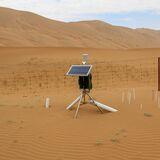
To accurately quantify the complexity of interactions in the critical zone (CZ), the thin layer at the Earth’s terrestrial surface, researchers have deployed arrays and networks of samplers and sensors to assess the measurable properties of CZ structure and function. They are capable of recording changes on hourly, daily, seasonal, and annual time scales that may be in response to climate change, geologic events, and human activities. As these technologies have become more advanced, integrated, cost effective, and remotely deployable, they are no longer simply used for monitoring but are being deployed for hypothesis testing. It is now possible to collect very large and targeted datasets to model whole systems, in addition to bolstering cause-and-effect paradigms.
This Research Topic was developed in order for CZ researchers to disseminate and share detailed accounts of the technologies and systems being deployed to measure the combined subsurface processes with surface and surface-atmosphere interactions. With the rapid development of sensor sophistication and system architecture, there is a greater need for communication within the CZ community to demonstrate what capabilities are possible. The most recent advances are being coupled with information technology systems that can deliver data to end users in real-time.
For this collection, we are interested in compiling papers from the international critical zone community that documents different sensing and sampling systems deployed to make observations of processes, fluxes, and perturbations that span different temporal and spatial scales across varying landscapes and environments. We are particularly interested in leveraging novel systems and procedures capable of measuring a broad range of subsurface and ecosystem properties. This data will form the foundation for developing numerical simulations and mathematical models. We welcome contributions that use these data through both traditional and AI-based methods and inform decision-making for ecosystem management, environmental protection, and resource development.
This Research Topic accepts the following article types, unless otherwise specified in the Research Topic description:
Articles that are accepted for publication by our external editors following rigorous peer review incur a publishing fee charged to Authors, institutions, or funders.
Keywords: critical zone science, sensing, geophysics, Big Data
Important note: All contributions to this Research Topic must be within the scope of the section and journal to which they are submitted, as defined in their mission statements. Frontiers reserves the right to guide an out-of-scope manuscript to a more suitable section or journal at any stage of peer review.
Manuscripts can be submitted to this Research Topic via the main journal or any other participating journal.
Submit your idea
You will be redirected to our submission process.
