 Juan Jose Dañobeitia1,2*
 Sylvie Pouliquen3,4
 Truls Johannessen5,6
 Alberto Basset7,8
 Mathilde Cannat1,9
 Benjamin Gerrit Pfeil5
 Maria Incoronata Fredella1
 Paola Materia1,10
 Claire Gourcuff3
 Giuseppe Magnifico1,11
 Eric Delory1,12
 Joaquin del Rio Fernandez1,13
 Ivan Rodero1*
 Laura Beranzoli1,10
 Ilaria Nardello14
 Daniele Iudicone14,15
 Thierry Carval3,4Juan M. Gonzalez Aranda7
 George Petihakis1,16,17
 Jerome Blandin1,4
 Werner Leo Kutsch5
 Janne-Markus Rintala5,18
 Andrew R. Gates1,19
 Paolo Favali1,10
- 1European Multidisciplinary Seafloor and water-column Observatory (EMSO ERIC), Rome, Italy
- 2Consejo Superior de Investigaciones Científicas (CSIC-UTM), Barcelona, Spain
- 3European Contribution to the Argo Programme (Euro-Argo ERIC), Brest, France
- 4Institut Français De Recherche Pour L’Exploitation De La Mer (IFREMER), Brest, France
- 5Integrated Carbon Observation System (ICOS-ERIC), Helsinki, Finland
- 6Geophysical Institute, University of Bergen, Bergen, Norway
- 7European e-Infrastructure on Biodiversity and Ecosystem Research (LifeWatch ERIC), Seville, Spain
- 8Department of Biological and Environmental Sciences and Technologies, University of Salento, Lecce, Italy
- 9Equipe de Géosciences Marines, Université de Paris, Institut de Physique du Globe de Paris (IPGP), Paris, France
- 10Integrated Systems for Marine Environmental Infrastructures, Istituto Nazionale di Geofisica e Vulcanologia (INGV), Rome, Italy
- 11Consiglio Nazionale delle Ricerche (CNR), Rome, Italy
- 12Plataforma Oceánica de Canarias (PLOCAN), Telde, Spain
- 13SARTI Research Group, Electronics Department, Universitat Politècnica de Catalunya (UPC), Barcelona, Spain
- 14European Marine Biological Resource Centre (EMBRC), Stazione Zoologica “Anton Dohrn” (SZN), Naples, Italy
- 15European Marine Biological Resource Centre (EMBRC-ERIC), Paris, France
- 16European Global Ocean Observing System (EuroGOOS), Brussels, Belgium
- 17Hellenic Centre for Marine Research (HCMR), Athens, Greece
- 18Institute of Earth and Atmospheric Sciences (INAR), University of Helsinki, Helsinki, Finland
- 19National Oceanography Centre, Southampton, United Kingdom
Research Infrastructures (RIs) are large-scale facilities encompassing instruments, resources, data and services used by the scientific community to conduct high-level research in their respective fields. The development and integration of marine environmental RIs as European Research Vessel Operators [ERVO] (2020) is the response of the European Commission (EC) to global marine challenges through research, technological development and innovation. These infrastructures (EMSO ERIC, Euro-Argo ERIC, ICOS-ERIC Marine, LifeWatch ERIC, and EMBRC-ERIC) include specialized vessels, fixed-point monitoring systems, Lagrangian floats, test facilities, genomics observatories, bio-sensing, and Virtual Research Environments (VREs), among others. Marine ecosystems are vital for life on Earth. Global climate change is progressing rapidly, and geo-hazards, such as earthquakes, volcanic eruptions, and tsunamis, cause large losses of human life and have massive worldwide socio-economic impacts. Enhancing our marine environmental monitoring and prediction capabilities will increase our ability to respond adequately to major challenges and efficiently. Collaboration among European marine RIs aligns with and has contributed to the OceanObs’19 Conference statement and the objectives of the UN Decade of Ocean Science for Sustainable Development (2021–2030). This collaboration actively participates and supports concrete actions to increase the quality and quantity of more integrated and sustained observations in the ocean worldwide. From an innovation perspective, the next decade will increasingly count on marine RIs to support the development of new technologies and their validation in the field, increasing market uptake and produce a shift in observing capabilities and strategies.
Introduction
Oceans are key to the Earth’s ecosystem; they regulate the transportation and storage of carbon dioxide, control the climate and absorb most of the heat excess from greenhouse gas emissions (Zanna et al., 2019). Parameters, such as temperature, acidity, and stratification of the oceans, affect the distribution of marine species and the functioning of marine ecosystems (Raven et al., 2005). Seventy percentage of the Earth’s volcanism occurs on the ocean floor, which together with large earthquakes and submarine landslides are the main sources of earthquakes and tsunamis. In addition, the impacts of pollution and eutrophication, coastal development and intensified agriculture, overexploitation of marine resources, and invasive species in the European marine environments are all well-documented and show no decreasing trend (Rovira and Pardo, 2006). Environmental RIs are essential to continuously assess and monitoring the current state of our oceans and undertake remedial actions. The RIs need to increase collaboration and interaction among them in order to enhance the efficiency and effectiveness of their work.
RIs are long-term scientific facilities sustained by strategic investments, which are indispensable for enabling and developing research in all scientific domains. They have broader socio-economic impacts through the advancement of knowledge, technological development and innovation (OECD, 2017). The European Commission (EC) supports, together with national funding, the development of RIs as ERICs, through the European Strategic Forum on Research Infrastructures (European Strategy Forum on Research Infrastructures [ESFRI], 2018) and targeted funds also for coordination among RIs. In the marine domain, RIs include specialized infrastructure that covers wide scientific fields at different depth scales from surface to deep seafloor (Figure 1A), in different stages of development (Figure 1B; European Strategy Forum on Research Infrastructures [ESFRI], 2018).
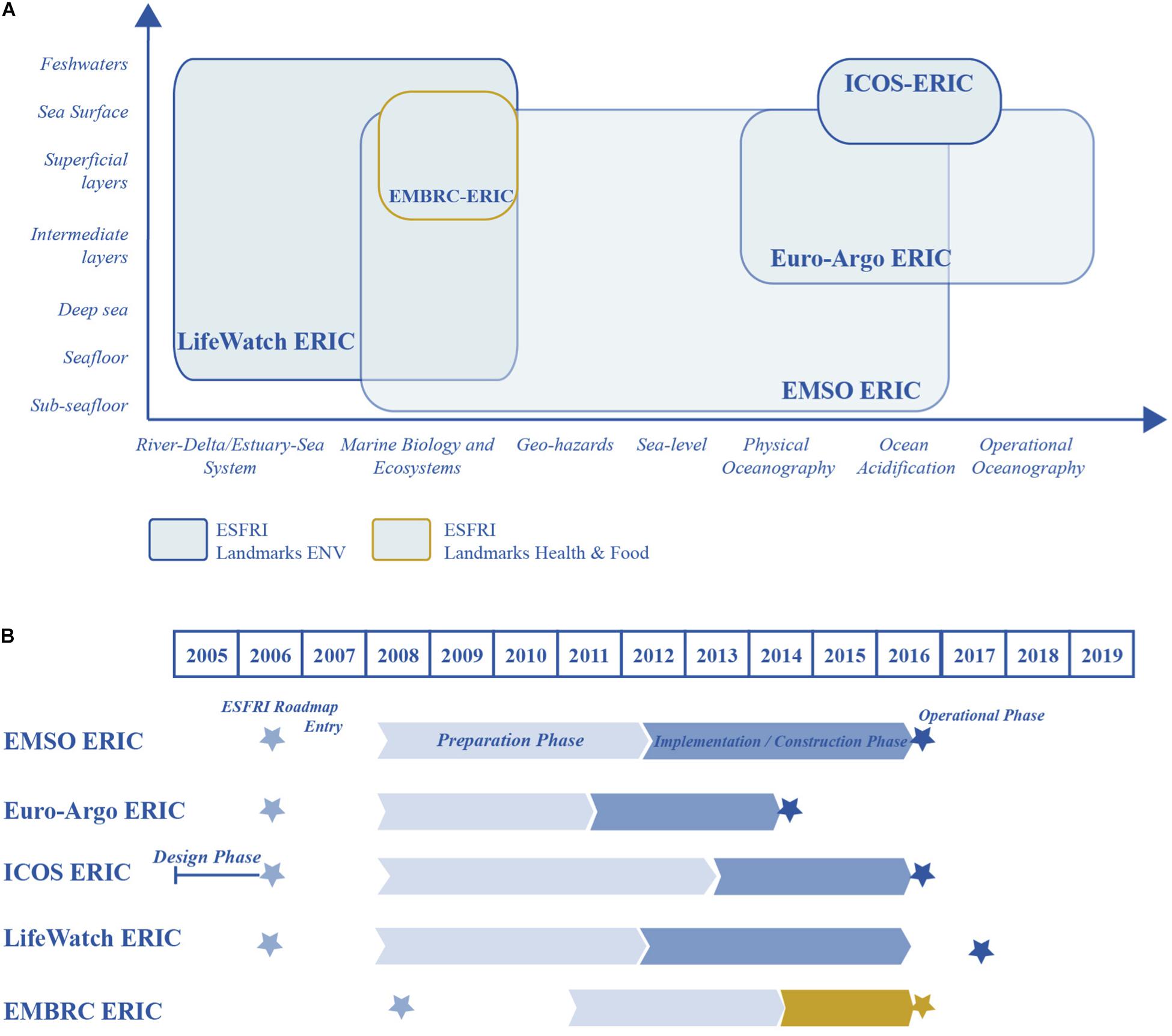
Figure 1. (A) Simplified diagram of the observation capabilities of five pan-European RIs with respect to their hydrosphere components (Y axis) and environmental processes (X axis); (B) Timeline of the five RIs since their entry in the ESFRI Roadmap [redrawn from European Strategy Forum on Research Infrastructures [ESFRI] 2018].
Five RIs provide the EC’s interconnected response to global marine challenges. EMSO ERIC1 comprises fixed-point multidisciplinary facilities in key deep seafloor and water-column environmental sites, recording long-term time series of Essential Ocean Variables (EOVs) and other parameters. Euro-Argo ERIC2 manages 25% of the Argo international programme of drifting floats, measures ocean properties and transmits the data in near-real-time. It aims to extend these measurements to greater depths, and to include other parameters like biogeochemistry. ICOS ERIC Marine3 measures green-house gas levels which underlie climate change and ocean acidification. LifeWatch ERIC4 characterizes biodiversity and ecosystem from mountain-to-coastal and deep seafloor, using data analysis and model testing through VREs. EMBRC-ERIC5 is dedicated to marine biota for advancing in marine biology and ecology research, to mitigate ecosystems degradation to points of no return, and to understanding the multiple stress factors affecting their functioning.
The RIs have reached their operational phase (Figure 1B) and can now begin to increase synergy between these RIs leading to the development of an integrated multi-platform observing system, reducing overlaps, filling gaps, increasing efficiency, adopting new technologies, and increasing spatial and temporal resolution to unprecedented levels. RIs have tremendous potential to deliver consilience, which is the outcome of our common effort to link facts and fact-theory across disciplines to develop a common platform to offer an explanation about physical phenomena and consequences of anthropogenic impacts (Wilson, 1998). Knowledge based on multidisciplinary evidence will allow researchers to understand complex global systems, and to adopt a sustainable use of the resources of our Planet. The synergic efforts among RIs is well suited with the strong recommendations of the OceanObs’19 Conference (OceanObs’19, 2019), and serves to support sustainable blue growth policies with human benefits related to the ocean.
Policy Drivers
The oceans are drivers for the European economy, have great potential for innovation and growth and greatly affect human well-being (see Ocean Health and Human Well-Being, 2020). Modern society demands investment in the acquisition of high-quality ocean data and the exchange of information. This implies a new kind of relationship between society needs, science-driven requirements, ocean policy coordination, and innovative management practices. In order for the ocean economy to meet the objectives of Blue Growth, an effective ocean services governance framework will need to be established, taking carefully into consideration the requirements of the different stakeholders and end-users (scientific and technological communities, SMEs, and industries and policy-makers). End-user engagement is at the heart of building and sustaining an ocean observing system. This will stimulate augmenting ocean observing capacity, facilitate sharing of infrastructure, promote best practices, build capacity, foster diversity, and develop innovative technologies and approaches.
Growing attention to the oceans and the need for a unified framework, imply synergies: (a) among the RIs, (b) toward a full access of data, (c) between international research and governmental sectors.
The EC Marine Strategy Framework Directive [MSFD] (2020) aims to achieve a Good Environmental Status (GES) of the EU’s marine waters by 2020 and protect its various resources, which are essential for socio-economic activities. Similarly, the OSPAR Coordinated Environmental Monitoring Programme (CEMP) aims to deliver comparable data from across the OSPAR Maritime Area, which can be used in environmental assessment. Meanwhile, the Blue Growth of the EC Framework Programmes, is the long-term strategy to support sustainable growth in the marine and maritime sectors.
The scientific community is currently preparing for the recently launched UN Decade of Ocean Science for Sustainable Development (2021–2030). This aims to create a common framework for the sustainable development of the oceans, which should lead to an integrated system for science-based solutions, including by building on existing technology and partnerships to “provide ocean science, data and information to inform policy for a well-functioning ocean in support of all sustainable development goals of the Agenda 2030” and “to generate scientific knowledge and underpinning infrastructure and partnerships” (UNESCO, 2019). Increased collaboration through different marine RIs will directly address these aims contributing to advance the frontiers of ocean observing capabilities from the coast to the deep ocean with a strategic trans-disciplinary marine research agenda for societal benefit, and addressing all the key priority areas of the UN Decade. The Decade is also expected to catalyze major investments in ocean science, stimulating national and regional linkage and the sustainability of the (European Global Ocean Observing System [GOOS], 2020).
EMSO ERIC: The Scope and Importance of Knowledge of the in situ Eulerian Observatories in the European Seas
EMSO ERIC is a distributed RI based on an integrated system of in situ Eulerian observatories. Its mission is the long-term observation of the deep seafloor and the water column by means of fixed-point multi-sensor platforms deployed in environmentally relevant sites of the European seas. It currently comprises eight Regional Facilities and three test sites distributed from the North Atlantic through the Mediterranean to the anoxic Black Sea (Figure 2B, green triangles).
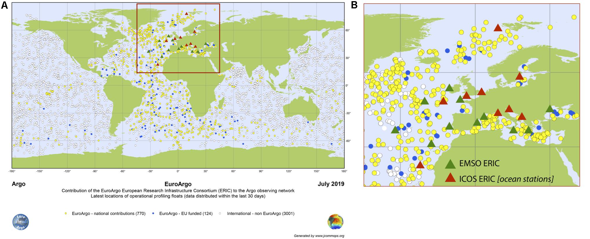
Figure 2. (A) Geographical distribution of the Argo Floats; (B) Zoom square displays: EMSO ERIC distributed Regional Facilities and test sites (green triangles), ICOS ERIC marine stations (red triangles).
EMSO’s main scientific objective is to help scientists to understand global environmental processes and stimulate the development of new technologies and knowledge. EMSO also pushes toward the adoption of standards in sensors and measurement methodologies for increasing its interoperability. The EMSO Generic Instrument Module [EGIM] (2020) was developed to measure and transmit seven EOVs (temperature, conductivity, pressure, dissolved O2, turbidity, ocean currents, and acoustics) in a standard and uniform way with the capacity of measuring also additional EOVs such as pCO2, pH, pCH4, chlorophyll-a, and time−lapse photography.
EMSO compiles long-term time series on climate change, marine ecosystems and marine hazards, which represent scientific and societal challenges (Ruhl et al., 2011; Best et al., 2014). Long time-series help to understand and mitigate the harmful effects of the global processes and document and study episodic events, such as earthquakes, tsunamis, benthic storms, biodiversity changes, pollution, and gas hydrate (methane) release, dense water cascades, plankton blooms, water mass movements, and the influence of eddies (Ruhl et al., 2011), which are difficult to detect by short-term conventional marine expeditions. Moreover, EMSO represents the European counterpart of global initiatives to establish permanent monitoring systems in deep waters (Favali et al., 2010, 2015).
Euro-Argo ERIC: Enhancing in situ Monitoring of the Ocean in the Earth’s Climate System
The Euro-Argo RI allows European countries to consolidate and improve their contributions to the international Argo Programme via commitments at ministerial/national levels. Argo is the first-ever, global, in situ ocean-observing Lagrangian network in oceanography, providing an essential complement to satellite observation systems, with a fully open data policy (Figure 2A).
The core Argo system is based on an array of more than 3,800 profiling floats, which measure temperature and salinity throughout the ocean, down to a depth of about 2,000 m, delivering data both in real-time for operational users and delayed mode for climate change research and monitoring (Riser et al., 2016). The new phase of the Argo Programme (Roemmich et al., 2019) has two main objectives: (1) to sustain the existing global array and (2) to extend its capabilities deeper to seafloor and to biogeochemistry, i.e., measuring new parameters such as oxygen, nitrate, chlorophyll-a and pH. Furthermore, at European level, additional efforts are being put into place to develop Argo capabilities in partially ice-covered regions and in the European marginal seas (the Black and Baltic Seas).
ICOS ERIC Marine: Monitoring Greenhouse Gas Fluxes to Understand Environmental Change and Ocean Acidification
ICOS ERIC measures greenhouse gas fluxes from ecosystems and oceans, and greenhouse gas concentrations in the atmosphere via sustained long-term monitoring, which is crucial to understanding variability at different time scales and making predictions under expected environmental change (Bakker et al., 2016). The ICOS marine network contributes the global observing community and helps to develop global monitoring data such as Surface Ocean CO2 Atlas [SOCAT] (2020) (Pfeil et al., 2013). The network currently consists of 21 stations, 11 Voluntary Observing Ships/Ships of Opportunity (VOS/SOOP) and 10 fixed stations across the North Atlantic, the Barents Sea, the North Sea, the Baltic Sea and the Mediterranean, operating in a harmonized and standardized way. ICOS marine stations (Figure 2B, red triangles) are operated on the basis of community-proven protocols and methods for ocean greenhouse gas (GHG) observations and support the operational conformity, as well as quality control and data assurance. ICOS data are processed and distributed on a near real-time basis by ICOS Ocean Thematic Centre. ICOS strongly supports and works closely with the international biogeochemistry community under the umbrella of the GOOS biogeochemistry panel (see GLODAP, 2020) and the (International Ocean Carbon Coordination Project [IOCCP], 2020). ICOS participates in the management of marine data through IOC UNESCO’s (International Oceanographic Data and Information Exchange [IODE], 2020) and COPERNICUS Marine Environmental Monitoring Services.
LifeWatch ERIC: Assessing and Modeling the Multiple Environmental Drivers of Change for Biodiversity and Ecosystem Functioning
LifeWatch is the European e-Infrastructure on Biodiversity and Ecosystem Research. LifeWatch’s focus includes changes in climate, demographic pressure, pollution, and soil consumption, which are responsible for biological diversity loss and ecosystem functioning change, which ultimately negatively impact the well-being of today’s society.
The overall scientific challenge of LifeWatch is to model biodiversity changes on Earth (Arvanitidis et al., 2016). The specific challenges are: (a) reliably and continuously collect, store, manage, process, analyze, and disseminate data on various biodiversity variables, such as diversity, biomass, productivity, coupled with the relevant socio-economic ones; (b) analyze the patterns, processes and consequences from possible changes on biodiversity and society welfare by providing the competitive VREs which offer integrative ways to asses environmental changes and risks; (c) offer prognoses on biodiversity composition, distribution, and functioning under certain scenarios (Basset and Los, 2012).
Accordingly, the Marine LifeWatch VRE offers access to aggregated data resources on marine biodiversity and marine ecosystem functioning. It has been established through the integration of resources originally developed by large global initiatives, such as the World Register of Marine Species (WoRMS), the Global Biodiversity Information Facility (GBIF) and the Group on Earth Observation (GEO), along with other RIs and projects.
EMBRC-ERIC: Services, Technologies, and Platforms for Marine Biology and Ecology Research
EMBRC-ERIC is a RI designed to further fundamental and applied marine biology and ecology research. Its state-of-the-art facilities are distributed in renowned marine biological stations and institutes across Europe. The vision of EMBRC-ERIC is to be a global RI reference, complementary to other marine RIs, for fundamental and applied marine biology and ecology research and a single-entry-point for a wide range of services, resources and knowledge. Its priorities are as follows:
• Understanding marine ecosystem for healthy future oceans;
• Resolving the extent of the world’s ocean marine biodiversity;
• Unlocking the potential of the marine realm for new biomaterials;
• Developing scenarios for changing oceans (e.g., through the improvement of ecological models);
• Enabling technologies, standards, and methods supporting scientific breakthroughs and applications in medicine, nutrition and aquaculture, among other sectors.
Existing Synergies Between the Marine RIs
The European marine RIs already have important synergies that can be further developed and enhanced in future to create a more integrated European observing system. For example the EMSO fixed-point observatories can provide high-resolution information about a broad range of parameters, representative of different spatial footprints of the ocean depending on parameter (Henson et al., 2016) providing context and validation for the data collected by Argo and ICOS RIs. Examples exist of observations at shared locations such as fixed point stations in the EMSO RI that also support observations for ICOS. The high resolution data from the fixed-point station providing validation for ICOS ships of opportunity data (and vice versa) (Macovei et al., 2020). In this example, the use of shared platforms also improves efficiency in servicing of infrastructure. Time-series data from a range of different marine ecosystems collected at EMSO Regional Facilities can support understanding of environmental change that affects ecological studies at EMBRC labs while EMBRC and EMSO directly benefit from the services of LifeWatch, such as World Register of Marine Species (Horton et al., 2019).
Another example is the development of biodiversity indicators with physical and biogeochemical data in the frameworks of GOOS, MSFD, and United Nations Division for Sustainable Development Goals [UN-SDGs] (2020). As indicated by the G7 Future of Seas and Oceans Working Group, the most efficient way to proceed for its implementation is to start with the coordinated and integrated augmentation of existing platforms. This needs to be cost-effective, building upon pre-existing knowledge of local ecosystems and allowing efficient capacity building, knowledge transfer, including the development of new sensors for automated monitoring. Evidently, the EU RIs are well placed to bring this strategy forward and act as catalyzers of all connected initiatives.
Toward a Coherent, Integrated System of RIS
There is a need to sustain, integrate, and further develop marine RIs in Europe that generate key data for scientific communities. For example, the European Global Ocean Observing System [GOOS] (2020) contributes to the Global Earth Observation System of Systems [GEOSS] (2020). Some RIs comprises the marine component of the forthcoming (European Ocean Observing System [EOOS], 2020), a coordinating framework designed to align and integrate Europe’s ocean observing capacity, together with the Earth Observation (EO) component. Marine RIs are also feeding into the EU’s flagship (COPERNICUS, 2020) programme. RIs’ linkages with the Joint Programming Initiatives [JPIs] (2020) and with other initiatives such as European Marine Observation and Data Network [EMODNET] (2020), European Environment Agency [EEA] (2020) and the EU Infrastructure for Spatial Information in Europe Directive [INSPIRE] (2020) Directive should be strengthened. Due to its complexity, the environmental domain should be observed with an integrated, coherent and distributed approach, considering that the processes under study vary from very small to broad observation scales, and from very short to long time scales.
Coordination among environmental RIs started within (ENVRIplus, 2020). This EC project selected common topics across RIs favoring the exchange of experiences and best practices and the study and outlining of common solutions to common problems, including those related to technology, e.g., power supply devices and low-power; data and metadata; and access to RIs, i.e., to use the RIs’ facilities. The Envri-Fair (2020) project focuses on setting the framework and roadmap for the adoption of the Findable, Accessible, Interoperable, Reusable (FAIR) principles in the data management of each RI.
Collaboration is essential to provide solutions to complex issues that cannot be solved by one partner alone. Europe has the resources and capacity to make comprehensive ocean observations for the benefit of society. Efforts must be made to develop a business model that ensures the long-term economic sustainability of ocean observatories that will involve co-design with all stakeholders, with a continuous process of planning, implementation and review of an integrated, complete and effective ocean observing system (European Marine Board, 2019).
Technological Development
Marine RIs support the development of advanced technologies for successful implementation of key European policy goals such as achieving GES under the MSFD. Efforts are being made, for example, to identify and promote best practices for the design and operation of ocean monitoring systems (Pearlman et al., 2019) to foster the implementation of interoperable solutions between different RIs and develop new and innovative technologies to expand the range of EOVs measured (particularly biological and biogeochemical EOVs; Levin et al., 2019) also with the depth, addressing low-power, miniaturization, modularity, interoperability, and cost-efficiency. The technological development is also sustained by strong training components to open up new job opportunities, linking the RIs and industries. Industries can also benefit from the work of RIs through collaboration. Sensor manufacturers have access to a larger market as the network of observatories and platforms expands. They may also benefit from access to test facilities and transnational access programs. Renewable energy, Resource extraction industries (e.g., oil and gas, deep-sea mining), fisheries and aquaculture can also benefit from access to data products and services provided by RIs and through co-design and co-development, resource assessment, environmental impact mitigation. Novel technology has an important role in making new solutions available to address the current societal challenges. Advances in ocean robotics, for example, and the combination of remote and in situ ocean observations offer new opportunities and reduce operational costs; this will also promote multi-stakeholder contributions by governments, the private sector and citizens (European Marine Board, 2019).
As new sensors, platforms and monitoring strategies are required to address an increasing number of variables, in particular when it comes to assess the quality of ecosystems, European marine RIs are also increasingly requested to contribute to the technological value chain. RIs will increasingly be requested to offer access to the community for tests in open-ocean conditions for long periods of time. Field validations operated at sites routinely monitored and data-quality controlled, will contribute to the improvement of technological readiness, bridge the gap between prototype testing to operational validation, and as a result increase market uptake.
Interactions With Ship Operators, Data Platforms
Understanding the functioning and assessing the status of the marine ecosystems require the monitoring of multiple-stressor impacts with a multi-parametric integration of observations. To meet the needs of the evolving ocean observing systems, high-level cooperation is established between RIs and the research vessel operators, through the European Research Vessel Operators [ERVO] (2020) and International Research Ship Operators [IRSO] (2020) groups. This cooperation is useful for implementing long-term operation planning for the deployment of new observing systems with a cost-efficient maintenance. To this aim, the H2020 Eurofleets + project (2019–2023) will play a key role in the coordinated use of vessels to support marine RIs such as EMSO, Euro-Argo or organizations such as EuroGOOS (Eurofleets+, 2020).
As stated by the G7 Future of Seas and Oceans Working Group, augmenting marine observatories with biological observations based on new technologies, such as multi-“omics,” will dramatically improve the monitoring of the status of the marine ecosystems (from microbes to fish). In the near future, new technologies will permit wide-range, cost-efficient monitoring of several ecosystem properties, including biodiversity status, environmental degradation responses, and invasive- or harmful-species occurrences.
Information Technologies: Big Data Infrastructures, and Data Quality and Standards Toward Interoperability
The scientific communities and the RIs are advancing in the adoption of the FAIR principles contributing to the development of international networks and observing systems, including how to reduce human intervention through signal processing, computer vision, and machine learning to translate time-series data into scored metrics and indicators. However, as data volume and rates increase, current data management systems may not be effective for real-time processing, quality control, event detection, and distribution of high-frequency data. The information technology (IT) industry is addressing these challenges by developing big data solutions for global production systems which requires faster data analytics to take advantage of advances in machine learning. This trend is analogous in scientific observing systems and RIs global learning. To date, automated big data analysis, machine learning methods, and cloud abstractions have been little integrated into scientific observing systems and RIs. Supporting data-driven workflows has the potential to automate the discovery of natural phenomena and deliver services based on (near)-real-time for multiple stakeholders through a diverse range of mechanisms. For example, a fundamental IT component of the EMSO cyber-infrastructure enables data integration from the EMSO Regional Facilities through a data management platform (DMP), which is designed to be scalable and open source for long-term data acquisition, archiving, and end-to-end data management.
Conclusion
Marine RIs constitute a dynamic infrastructure framework, supported by European and national funds, to facilitate research, providing highly accurate data and services. They can attract investments and contribute broadly to socio-economic development, and promote innovation (OECD, 2019). These achievements are based on marine science and technology activities, with strong training component that can open up new job opportunities and provide high-quality and sensible environmental data to support a variety of public, societal and industrial stakeholders and co-develop solution-oriented trans-disciplinary marine research agenda with the governance of sustainability at its core.
RIs collaboration is emphasizing the development of multi-sensor technologies and the adoption of multi-parameter and interoperable methodologies for integrated and sustained marine observations. This is expected to favor the implementation of data processing pipelines and information exchange across a large variety of observations, responding to societal demands, supporting the Paris Agreement, whose main objective is to constrain the global temperature rise below 2°C (UNFCC, 2018).
Addressing environmental challenges is crucial for humanity and for life on Earth, and will depend on accurate information about fundamental processes in the geosphere, hydrosphere, biosphere and atmosphere, and their interactions. Marine RIs are key tools for understanding these complexities and interrelationships through multi-, inter-disciplinary approaches. Joint collaboration through the use of marine RIs are key value-added tools to understand the complex processes and interrelationships using a multidisciplinary approach to understand the oceanic system, strengthen safety and protection at sea and mitigate the risks related to climate change, anthropogenic pollution, and loss of biodiversity among other stressors for the benefit of future generations. This can be achieved by European marine RIs working to increase the capacity to monitor the EOVs-Essential Ocean Variables (particularly the biological and biogeochemistry EOVs), MSFD indicators, Sustainable Development Goal tasks and indicators among other sets of parameters over increased depth ranges and spatial scales. The RIs will develop methods to ensure that data products, information, and knowledge are provided to stakeholders efficiently in a way that is directly relevant to their requirements.
Author Contributions
JD provided the overall guidance and contributed to writing most of the sections together with PF who additionally made a global revision of the manuscript. SP and CG wrote section Interactions With Ship Operators, Data Platforms and contributed to the revision of the text. TJ, BP, IR, JR, and WK wrote section Information Technologies: Big Data Infrastructures, and Data Quality and Standards Toward Interoperability and contributed to the revision of the text. AB, MC, MF, PM, ED, LB, JB, IN, DI, TC, JG, and J-MR contributed to the elaboration of the text. IR, GP, and AG contributed to the text and its revision. GM provided the figures and contributed to writing the text. JD, JR, ED, and AG contributes to the revision process of the proof version.
Conflict of Interest
The authors declare that the research was conducted in the absence of any commercial or financial relationships that could be construed as a potential conflict of interest.
Funding
Parts of this paper have been supported by EU projects EMSODEV contract 676555 (see EMSODEV, 2020), and EMSO-Link contract 731036. Additionally, we gratefully acknowledge the support of their home institutions.
Footnotes
References
Arvanitidis, C., Chatzinikolaou, E., Gerovasileiou, V., Panteri, E., Bailly, N., Minadakis, N., et al. (2016). LifeWatchGreece: construction and operation of the national research infrastructure (ESFRI). Biodiv. Data J. 4:e10791. doi: 10.3897/bdj.4.e10791
Bakker, D. E. E., Pfeil, B., Landa, C. S., Metzl, N., O’Brien, K. M., Olsen, A., et al. (2016). A multi-decade record of high quality fCO2 data in version 3 of the Surface Ocean CO2 Atlas (SOCAT). Earth Syst. Sci. Data 8, 383–413. doi: 10.5194/essd-8-383-2016
Basset, A., and Los, W. (2012). Biodiversity e-science: lifeWatch, the European infrastructure on biodiversity and ecosystem research. Plant Biosyst. Int. J. Deal. Aspects Plant Biol. 146, 780–782. doi: 10.1080/11263504.2012.740091
Best, M. M. R., Favali, P., Beranzoli, L., Cannat, M., Çağatay, N. M., Dañobeitia, J. J., et al. (2014). EMSO: a distributed infrastructure for addressing geo-hazards and global ocean change. Oceanography 27, 167–169. doi: 10.5670/oceanog.2014.52
COPERNICUS (2020). European Programme for the Establishment of a European capacity for Earth Observation. Available at: https://www.copernicus.eu (accessed May 19, 2019).
EMSO Generic Instrument Module [EGIM] (2020). Available at: https://www.emsodev.eu (accessed May 19, 2019).
EMSODEV. EMSO Implementation and Operation: DEVelopment of Instrument Module. Available at: https://www.emsodev.eu (accessed May 19, 2019).
Envri-Fair (2020). ENVironmental Research Infrastructures Building Fair services Accessible for Society, Innovation and Research. Available at: http://envri.eu/envri-fair/ (accessed May 19, 2019).
ENVRIplus (2020). Supporting Environmental Research with Integrated Solutions. Available at: https://www.envriplus.eu/ (accessed May 19, 2019).
Eurofleets+ (2020). EC Project. Available at: www.eurofleets.eu (accessed May 19, 2019).
European Environment Agency [EEA] (2020). Available at: www.eea.europa.eu (accessed May 19, 2019).
European Global Ocean Observing System [GOOS] (2020). Available at: http://eurogoos.eu (accessed May 19, 2019).
European Marine Board (2019). Navigating the future V: marine science for a sustainable future. Paper Presented at 24 of the European Marine Board (Ostend: European Marine Board).
European Marine Observation and Data Network [EMODNET] (2020). Available at: http://www.emodnet.eu/ (accessed May 19, 2019).
European Ocean Observing System [EOOS] (2020). Available at: www.eoos-ocean.eu (accessed May 19, 2019).
European Research Vessel Operators [ERVO] (2020). Available at: www.ervo-group.eu (accessed May 19, 2019).
European Strategy Forum on Research Infrastructures [ESFRI]. (2018). Strategy Report on Research Infrastructures in Europe, Roadmap 2018. Available at: http://roadmap2018.esfri.eu (accessed May 19, 2019).
Favali, P., Beranzoli, L., and De Santis, A. (eds) (2015). Seafloor Observatories: A New Vision of the Earth from the Abyss, Springer-Praxis books in Geophysical Sciences. Berlin: Springer-Verlag.
Favali, P., Person, R., Barnes, C. R., Kaneda, Y., Delaney, J. R., and Hsu, S.-K. (2010). “Seafloor Observatory Science,” in Proceedings of the OceanObs’09: Sustained Ocean. Observations and Information for Society, Vol. 2, eds J. Hall, D. E. Harrison, and D. Stammer (Venice: ESA Publication).
Global Earth Observation System of Systems [GEOSS] (2020). Available at: https://www.earthobservations.org/geoss.php (accessed May 19, 2019).
Global Ocean Observing System [GOOS] (2020). Available at: https://www.goosocean.org (accessed May 19, 2019).
GLODAP. Global Ocean Data Analysis Project. Available at: https://www.glodap.info/ (accessed May 19, 2019).
Henson, S. A., Beaulieu, C., and Lampitt, R. (2016). Observing climate change trends in ocean biogeochemistry: when and where. Glob. Chang. Biol. 22, 1561–1571. doi: 10.1111/gcb.13152
Horton, T., Kroh, A., Ahyong, S., Bailly, N., Boyko, C. B., Brandão, S. N., et al. (2019). World Register of Marine Species (WoRMS). Available online at: http://www.marinespecies.org at VLIZ. (accessed November 12, 2019).
Infrastructure for Spatial Information in Europe Directive [INSPIRE] (2020). Available at: https://inspire.ec.europa.eu/ (accessed May 19, 2019).
International Ocean Carbon Coordination Project [IOCCP] (2020). Available at: http://www.iocunesco.org/index.php?option=comcontent&view=article&id=7:internationalocean-carbon-coordination-project&catid=5&Itemid=112 (accessed May 19, 2019).
International Oceanographic Data and Information Exchange [IODE] (2020). Available at: www.iode.org (accessed May 19, 2019).
International Research Ship Operators [IRSO] (2020). Available at: www.irso.info (accessed May 19, 2019).
Joint Programming Initiatives [JPIs] (2020). Available at: https://ec.europa.eu/programmes/horizon2020/en/h2020-section/joint-programming-initiatives (accessed May 19, 2019).
Levin, L. A., Bett, B. J., Gates, A. R., Heimbach, P., Howe, B. M., Janssen, F., et al. (2019). Global observing needs in the deep Ocean. Front. Mar. Sci. 6:241. doi: 10.3389/fmars.2019.00241
Macovei, V. A., Hartman, S. E., Schuster, U., Torres-Valdés, S., Moore, C. M., and Sanders, R. J. (2020). Impact of physical and biological processes on temporal variations of the ocean carbon sink in the mid-latitude North Atlantic (2002-2016). Prog. Oceanogr. 180:102223. doi: 10.1016/j.pocean.2019.102223
Marine Strategy Framework Directive [MSFD] (2020). Available at: https://ec.europa.eu/info/research-and-innovation/research-area/oceans-and-seas/eu-marine-strategy-framework-directive_en (accessed May 19, 2019).
Ocean Health and Human Well-Being. Available at: http://documents.worldbank.org/curated/en/111381468155703584/Indispensable-ocean-aligning-ocean-health-and-human-well-bei ng-guidance-from-the-blue-ribbon-panel-to-the-global-partnerships-for-ocean (accessed May 19, 2019).
OceanObs’19 (2019). Conference Statement. Available at: http://www.oceanobs19.net/statement/
OECD (2017). Strengthening the Effectiveness and Sustainability of International Research Infrastructures. Paris: OECD Publishing.
OECD (2019). Reference Framework for Assessing the Scientific and Socio-Economic Impact of Research Infrastructures. Paris: OECD Publishing.
Pearlman, J., Bushnell, M., Coppola, L., Karstensen, J., Buttigieg, P. L., Pearlman, F., et al. (2019). Evolving and sustaining ocean best practices and standards for the next decade. Front. Mar. Sci. 6:277. doi: 10.3389/fmars.2019.00277
Pfeil, B., Olsen, A., Bakker, D., Hankin, S., Koyuk, H., Kozyr, A., et al. (2013). A uniform, quality-controlled surface ocean CO2 atlas (SOCAT). Earth Syst. Sci. Data 5, 125–143.
Riser, S. C., Freeland, H. J., Roemmich, D., Wijffels, S., Troisi, A., Belbeoch, M., et al. (2016). Fifteen years of ocean observations with the global Argo array. Nat. Clim. Change 6, 145–153. doi: 10.1038/nclimate2872
Roemmich, D., Alford, M. H., Claustre, H., Johnson, K., King, B., Moum, J., et al. (2019). On the future of argo: a global, full-depth, multi-disciplinary array. Front. Mar. Sci. 6:439. doi: 10.3389/fmars.2019.00439
Rovira, J. L., and Pardo, P. (2006). Nutrient pollution of waters: eutrophication trends in European marine and coastal environments. Contrib. Sci. 3, 181–186. doi: 10.2436/20.7010.01.4
Ruhl, H. A., André, M., Beranzoli, L., Çağatay, M. N., Colaço, A., Cannat, M., et al. (2011). Societal need for improved understanding of climate change, anthropogenic impacts, and geo-hazard warning drive development of ocean observatories in European Seas. Prog. Oceanogr. 91, 1–33. doi: 10.1016/j.pocean.2011.05.001
Surface Ocean CO2 Atlas [SOCAT] (2020). Available at: https://www.socat.info/ (accessed May 19, 2019).
UNESCO (2019). UN Decade of Oceanic Science for Sustainable Development (2021-2030). Available at: https://en.unesco.org/ocean-decade
UNFCC (2018). Progress Tracker Paris Agreement Work Programme. Available at: https://unfccc.int/process-and-meetings/the-paris-agreement/the-paris-agreement
United Nations Division for Sustainable Development Goals [UN-SDGs] (2020). Sustainable Development Goals (SDGs). Available at: https://sustainabledevelopment.un.org/ (accessed May 19, 2019).
Keywords: European marine Research Infrastructures (RIs), multi- and inter-disciplinary ocean observing systems, global change, geo-hazards, marine ecosystem
Citation: Dañobeitia JJ, Pouliquen S, Johannessen T, Basset A, Cannat M, Pfeil BG, Fredella MI, Materia P, Gourcuff C, Magnifico G, Delory E, del Rio Fernandez J, Rodero I, Beranzoli L, Nardello I, Iudicone D, Carval T, Gonzalez Aranda JM, Petihakis G, Blandin J, Kutsch WL, Rintala J-M, Gates AR and Favali P (2020) Toward a Comprehensive and Integrated Strategy of the European Marine Research Infrastructures for Ocean Observations. Front. Mar. Sci. 7:180. doi: 10.3389/fmars.2020.00180
Received: 01 November 2018; Accepted: 06 March 2020;
Published: 31 March 2020.
Edited by:
James Scott Maki, Marquette University, United StatesReviewed by:
R. Venkatesan, National Institute of Ocean Technology, IndiaGlen Gawarkiewicz, Woods Hole Oceanographic Institution, United States
S. Kim Juniper, University of Victoria, Canada
Copyright © 2020 Dañobeitia, Pouliquen, Johannessen, Basset, Cannat, Pfeil, Fredella, Materia, Gourcuff, Magnifico, Delory, del Rio Fernandez, Rodero, Beranzoli, Nardello, Iudicone, Carval, Gonzalez Aranda, Petihakis, Blandin, Kutsch, Rintala, Gates and Favali. This is an open-access article distributed under the terms of the Creative Commons Attribution License (CC BY). The use, distribution or reproduction in other forums is permitted, provided the original author(s) and the copyright owner(s) are credited and that the original publication in this journal is cited, in accordance with accepted academic practice. No use, distribution or reproduction is permitted which does not comply with these terms.
*Correspondence: Juan Jose Dañobeitia, anVhbmpvLmRhbm9iZWl0aWFAZW1zby1ldS5vcmc=; Ivan Rodero, aXJvZGVyb0BydXRnZXJzLmVkdQ==