Abstract
What happens to floodplain buyout sites after demolition of structures? Does ecological restoration or reconciliation of the floodplain occur? By what criteria should we assess what is on the site? Under what conditions do government programs promote more ecologically dynamic land management? We explore these questions in the context of four exemplary buyout programs in the United States that implement relocation out of flood risk zones through buyouts: Austin’s Watershed Protection Department, Texas; Harris County Flood Control District, Texas; Charlotte-Mecklenburg’s Stormwater Services, North Carolina; and Washington State’s Floodplains by Design. The analysis draws on staff interviews and GIS mapping, satellite imagery for 3,416 buyout parcels spanning 2,811 acres, and selected field verification. We test a framework for assessing buyouts that includes both pre- and post-buyout considerations as indicators along a spectrum from reconciliation to restoration. Our findings show that the status of most buyout parcels is “in-waiting,” as land management practices evolve to decide on their long-term use. Federal buyout requirements prevent redevelopment, but it is local and state priorities, goals, capacities, partnerships and levels of community engagement that shape land management outcomes and long-term human-nature relations. While the reconciliation-restoration debate often pits social against ecological goals, we find that they are mutually reinforcing, and that deep community engagement yields better outcomes overall. Floodplains are high value landscapes and should be prioritized for repair. State and federal governments can help achieve greater ecological and social outcomes from buyout sites by issuing more explicit guidance, technical assistance, and funding support to achieve these aims.
1 Introduction
Floodplains are some of the most biodiverse and human-impacted environments in the world (Ward et al., 1999). As climate change increases the frequency, severity, and reach of floods (Crimmins et al., 2023), some people are relocating out of flood-prone areas. While policymakers and many departing residents hope that this sacrifice will leave behind restored landscapes (Koslov, 2016), little is known about what actually happens to sites after people leave and structures are demolished (Zavar and Hagelman III, 2016). Do the lands become restored? To what? By what criteria should we assess their condition? Under what circumstances do programs repair more sites to an ecologically dynamic condition?
We explore these questions in the context of four programs in the United States that implement relocation out of flood risk zones through government acquisitions or buyouts in Austin, Texas; Houston, Texas; Mecklenburg County, North Carolina; and Washington State. We argue that there is no singular goal or strategy for repair, but a spectrum of options, from ecological “restoration” to “reconciliation,” driven by local social and developmental conditions. We analyze satellite imagery and use field verification to assess the extent to which the 3,416 buyout parcels spanning 2,811 acres in these four regions implement diverse land management strategies. We interview buyout program land managers to clarify and confirm results.
We find that each program adopts a different management strategy, resulting in distinct social and ecological outcomes. Nearly all sites meet the national standards set by the Federal Emergency Management Agency (FEMA) in its Hazard Mitigation Grant Program for buyouts, regardless of whether a particular parcel is purchased with funds from that program. That is, after the program purchases the property, structures are demolished and subsequent redevelopment is prohibited. This should permit the return of floodplain plant communities, processes, and functions. Some also try to minimize checkerboarding, or scattered buyouts sites, by mandating contiguous buyouts through eminent domain or incentivizing neighbors to participate in voluntary buyouts simultaneously. However, simply removing structures does not result in a restored floodplain. Our findings show that the state of the land correlates with other program goals for flood management and risk reduction, habitat restoration, recreation, or some combination, along with the capacity to maintain and manage these now vacant lands. A program that uses buyouts as a way to create new wildlife habitat tends to return sites to a more dynamic state, while those that prioritize social outcomes tend to create amenities like trails, benches, and recreational facilities.
These findings show that while federal requirements have helped prevent development on buyout properties, the tremendous variation in the long-term state of these lands is driven by the distinct goals of state and local buyout programs. Given the social inequities in where buyouts take place (Siders, 2019; Elliott et al., 2020), the different end states of repaired sites also have important implications for socio-economic impacts for remaining neighbors and relocated residents (Shi et al., 2023). State and federal governments can help achieve greater ecologically reparative or socially equitable outcomes for buyout sites by issuing more explicit guidance, technical assistance, and funding support to achieve these aims. Below, we first review the imperative of repairing buyout sites and the gap in achieving this goal, present our assessment framework and typologies of programmatic approaches, and then consider programs’ challenges and needs. Addressing these gaps and needs will help repair floodplain functions and habitats and promote climate adaptation for human and non-human species.
2 Floodplains, buyouts, and the gap in repair
2.1 The ecological value, growing impairment, and inequity of floodplains
Floodplains are ecologically important places (Opperman et al., 2013). Floodplains are lands defined by periodic flood disturbance where ecological and human systems often collide (Opperman et al., 2010; Tockner and Stanford, 2002; Ward et al., 1999). These landscapes have been described as among the most valuable and threatened ecosystems in the world (Opperman et al., 2017; Tockner and Stanford, 2002; Weigelhofer et al., 2020). Floodplains provide major ecological and economic benefits, including sediment and nutrient reduction, carbon sequestration, groundwater recharge, fisheries, recreation, biodiversity, seasonal agriculture, water quality improvement, and cultural placemaking (Opperman et al., 2017; Christin and Kline, 2017) but are degraded faster than any wetland type (Tockner and Stanford, 2002). In terms of per-hectare value to society, floodplains are second only to estuaries, providing 25% of all nonmarine ecosystem services on only 2% of the terrestrial surface area (Opperman et al., 2017; Costanza et al., 1997). Sheaffer et al. (2002) note that the ecological and natural values of floodplain lands, such as pollution abatement and groundwater recharge, can be worth up to 10 times the cost savings achieved through buyouts and flood risk reduction. Many floodplain ecosystem services are driven by a river’s dynamism, including periodic flooding, where rivers overtop their banks and spill over into adjacent low-lying lands (Ward et al., 2002; Stanford et al., 2005). The magnitude, frequency, duration, timing, and rate of change of water flows collectively create a river’s “natural flow regime” (Poff et al., 1997; Poff and Zimmerman, 2010; Zhang et al., 2012). The floods that modern society views as a problem to be fixed are part of this natural flow regime and necessary to maintain a river’s ecological integrity.
Floodplains have been highly developed (Opperman et al., 2017; Tockner and Stanford, 2002). Globally, 1.6 billion people were affected by flooding between 2000 and 2019, at a cost of $651 billion (UNDRR, 2025). Between 2011 and 2015 in the U. S., an estimated 30 million people were living in the combined flood risk zone, or the 1 and 0.2% annual chance of flooding, formerly known as the 100-year and 500-year flood risk zones, respectively (Peri et al., 2017). Wing et al. (2018) find that this number is grossly underestimated due to outdated flood maps. Over the last two decades, an additional 2.1 million acres of U. S. floodplains were developed (Samoray et al., 2024). A number of factors have led to an intensification of floodplain development in the U. S., despite the increasing magnitude of flood disasters. The National Flood Insurance Program (NFIP), once intended to disincentivize people from living in floodplains, inadvertently makes development in flood risk zones more palatable by shifting the costs of rebuilding onto the government (Browne et al., 2019; Christin and Kline, 2017; Silvis, 2018). Historically, the U. S. Army Corps of Engineers (USACE) and FEMA’s Hazard Mitigation Grant Program favor the construction of gray infrastructure such as levees (Walls and Liao, 2023; Sperl, 2022), which in turn gives the false impression of a development-safe zone in an infrastructure-protected area (Miao and Davlasheridze, 2022; Knox et al., 2022; Sutton-Grier et al., 2015). These federal supports have prevented real estate markets from internalizing the costs of repeated flood damages (Pappas and Platt, 2021). Outdated flood maps mislead prospective homebuyers regarding risk (Wing, et al., 2020), and cities continue to build in floodplains even as they remove some repetitively flooded properties through buyouts (Hino et al., 2024).
Globally, flood risk exposure and risk reduction are highly inequitable (Hallegatte et al., 2016; Winsemius et al., 2016). An estimated 19 million people in the U. S. live in census tracts with both a 1% chance of annual flood risk and high social vulnerability (Tate et al., 2021). More affordable housing is likely to be located in inland floodplains compared to other types of housing (Samoray et al., 2024). At the same time, flood risk reduction efforts also can be inequitable, with lower-income homeowners more likely to be offered a buyout while wealthier residents are offered home elevation grants, levees, or seawalls (Siders and Keenan, 2020). Mach et al.’s, 2019 study found that buyouts across the U. S. are more likely to occur in less densely populated areas that are relatively poorer, with lower education, more racial diversity and lower English language proficiency. Lower-income and minority residents receive fewer payments, have longer wait times, and move farther away, thereby distancing them from past social networks (Siders, 2019; Kraan et al., 2021; Elliott et al., 2021). For these households, the question of what happens with the land after a buyout can be all the more important in shaping decisions about whether to take a buyout, recovering from trauma, and sustaining social networks (Shi et al., 2023).
2.2 Evolving debates about how to repair floodplains
The field of ecology has evolved from a focus on preservation and conservation, to one on restoration, to increasingly a focus on reconciliation (Hobbs et al., 2014). Preservation and conservation aim to minimize the harms of human use and intervention. Advocates see restoration as a way to return land to its natural, “pre-development” state, often without regard for thousands of years of indigenous inhabitation and extensive land management (Grenz and Armstrong, 2023) and the deeply social, cultural, and political dynamics that have long shaped watersheds (Elias et al., 2021). The concept of reconciliation suggests that a negotiated outcome is acceptable, taking into account historical realities, ecological function, and social needs. In reality, restoration and reconciliation exist on a spectrum of overlapping options with no clear boundary between the two; this evolution reflects shifting balances of ecological and social values over time.
Ecological restoration efforts assist the recovery of an ecosystem that has been degraded, damaged, or destroyed (Gann et al., 2019). The Society for Ecological Restoration positions restoration projects along a continuum of increasing required inputs, from “reduced societal impacts” to remediation, to rehabilitation, and finally ecological restoration (Gann et al., 2019). A strong case can be made for supporting efforts to restore floodplains due to their high ecological value. Floodplains are highly productive ecotones supporting far more species than adjacent uplands (Tockner and Stanford, 2002). Restoration sets targets for a desired state that can be measured along two spectra: ecological integrity and historical fidelity (Higgs, 2003). The former is a holistic term related to ecosystem structure and function (Wurtzebach and Schultz, 2016), the latter considers not one fixed state but a historical range of variability, since no ecological system is static (Higgs, 2003). Restoration efforts in urbanized floodplains could involve actions such as restoring hydrologic connectivity via levee setbacks or removal, or reconstructing wetlands by removing fill soils and recreating microtopography. Restoring ecosystems to previous states requires knowledge of what was there before or close analogs, known as reference sites (Gann et al., 2019; Higgs, 2003; Higgs, 1997; Rosgen, 1998).
Restoration approaches, particularly in urban settings, raise numerous concerns and challenges. In places where human settlements and river floodplains coincide, full restoration of floodplain ecosystems and natural flow regimes may be difficult, if not virtually impossible, at least in the near-term. Achieving historical fidelity is challenging in part because although floodplains throughout the world have been altered and managed, sometimes for thousands of years, floodplain ecosystems were not studied extensively prior to their development and there is little site-specific data to draw from to set appropriate targets for restoration (Opperman et al., 2017). Urban floodplains and their watersheds have undergone extensive transformation (Walsh et al., 2005) including the channelization and concretization of rivers and creeks, addition of fill and numerous structures that decrease flood storage area, and removal of vegetation. Dramatic increases in ground compaction, impervious surfaces, and curb and gutter roadways funnel stormwater quickly, resulting in faster and higher peak flows in waterways (Konrad, 2003; O’Driscoll et al., 2010; Dunne and Leopold, 1978). And while buyouts “undevelop” the floodplain, waterways in cities are major amenities and there is an expectation that waterfront and public open space within urban areas is used, sometimes intensively, by the people who live there. These factors make goals of historical fidelity and ecological integrity challenging in urban floodplains (Figure 1).
Figure 1

A spectrum of possible floodplain landscapes. Reparative actions can shift lands from developed and largely impermeable flood risk zones (A) to a reconciled floodplain (B), with trails and greenways and other community uses such as community gardens and playing fields, to a restored floodplain (C), where ecological value is high, community use is secondary to habitat for non-human species, and floodplain functions maintain a creek’s ecological integrity. (Drawing by Xueting Jin).
Accordingly, many scholars and practitioners increasingly advocate the idea of “reconciliation.” In a 1997 paper, Eric Higgs warned of approaches to the nascent field of ecological restoration that are too technocratic and absolute, and instead advocated for more process-based approaches that bring people with diverse interests together to negotiate creative solutions. In doing so, he argued, authentic engagements between people and ecosystems heighten “place awareness” (Higgs, 1997). Higgs folded communities and cultures into the restoration process in a measure he called “cultural fidelity” that considers factors such as social justice, health and wellbeing, and traditional knowledge (Higgs, 2003). Before the early 2000s, most ecologists were preoccupied with studying “pristine” habitats as untouched by industrialized societies as possible. In a 2003 paper titled “Reconciliation Ecology and the Future of Species Diversity,” ecologist Michael Rosenzweig made an urgent call to adapt anthropogenic habitats so that they could be shared by more species, including humans. He used species-area equations to demonstrate that if we rely only on preservation/conservation and restoration, “we are doomed to lose nearly every species alive today” (Rosenzweig, 2003). Rosenzweig (2003) called the ecology that works with and in human-dominated habitats “reconciliation”.
Applying this idea to floodplains, Opperman et al. (2017) proposed reconciliation as an alternative to full-scale floodplain restoration, such that people are part of the ecosystem as active managers and participants, working toward a set of goals defined in relation to management needs and societal values. Many traditions worldwide have developed sophisticated ways to sustain rice cultivation, aquaculture, and rangelands in flood-dependent landscapes (Liu et al., 2022; Gebrekidan et al., 2020; Michael et al., 2023; International Livestock Research Institute, 2021). The Walking Wetlands project by the U. S. Fish and Wildlife Service (USFWS) floods farm fields for several consecutive seasons to provide wetland habitat for waterfowl. Farmers lose yields during this period but cite benefits such as the suppression of soil pathogens and better soil fertility (USFWS, 2021). These examples demonstrate how tradeoffs can be made to accommodate both people and functioning ecosystems in a shared space. Fully restoring the processes that sustain floodplains, as described by Beechie et al. (2010), may not be possible given the extent of watershed change, but building green infrastructure to counter the effects of impervious surfaces is an example of reconciliation. There is a real need to increase the performance of urban landscapes to support biodiversity and ecological function (Colding, 2007; Standish et al., 2013a, 2013b). In fact, more researchers are suggesting that human intervention is increasingly necessary to build resilience in landscapes due to the outsized disturbance of climate change (Besterman et al., 2022; Bilkovic et al., 2017; Palik et al., 2022).
2.3 Opportunities and gaps of buyouts in advancing floodplain repair
Floodplain repair provides an opportunity to restore floodplain ecosystems while improving equitable community resilience (FEMA, 2024). Given the social inequities of flood risk exposure and risk reduction efforts, the repair and stewardship of floodplains after buyouts can both support community-wide decision-making and facilitate the health and well-being of those who relocate or who remain (Shi et al., 2023). The long-term intended use of buyout land has been identified as an important factor in facilitating decision making, closure, and recovery (Baker et al., 2018; Binder and Greer, 2016; Binder et al., 2020), and knowing they are contributing to community open space eases stress for people who move (Baker et al., 2018; Reguero et al., 2018). Expediting the process of converting land to open space, or having a plan in place to do so, may alleviate concerns of more hesitant floodplain landowners in considering buyouts, thereby minimizing checkerboarding and negative socio-economic impacts of vacancy (Baker et al., 2018; Siders and Gerber-Chavez, 2021). Public education, engagement with community organizations, and inclusion of diverse local knowledge traditions in land management can also help build a sense of agency in the face of trauma.
However, buyouts programs are not doing enough on restoration (Zavar and Hagelman III, 2016). In a 2002 report, a Congressional Task Force on the Natural and Beneficial Functions of the Floodplain concluded that “restoring the natural and beneficial functions of floodplains will not only reduce flood damages, but also contribute to a community’s social and economic well-being… natural functioning floodplains will become increasingly critical community assets” (Task Force, i). The Task Force recommended updating and expanding national policies on the protection and restoration of floodplain functions, drafting a proactive and long-term approach to floodplain management, increasing capacity for planning processes, and focusing efforts on those areas of floodplains with the greatest risks and significant natural and beneficial functions (Task Force on the Natural and Beneficial Function of the Floodplain, 2002). It also cited the post-disaster opportunity to relocate structures, restore rivers and wetlands, and expand greenways.
Nevertheless, restoration of post-buyout land is hindered by a lack of funding and willing partners, lack of leadership and organizational capacity, conservation organizations prioritizing intact habitats, and checkerboarding (Kodis et al., 2021; Zavar and Hagelman, 2016). Federal funding for buyouts does not include additional money to restore the land. This leaves many buyout properties in a state of limbo. Zavar and Hagelman’s, 2016 study of land use change on federally funded buyout project sites between 1990 and 2000 found that 34.2% remained vacant lots. The FEMA Hazard Mitigation Grant Program turns buyouts over to municipalities, leaving them with the task and cost of mowing a scattershot of parcels, often to meet the esthetic preferences of remaining neighbors. Floodplain managers surveyed as part of a Zavar and Hagelman’s (2016) study revealed that a lack of guidance and open space planning caused buyouts to remain underutilized, or even end up being redeveloped (Schwab, 2021).
For the time being, most programs prioritize reducing risk using benefit–cost analysis in selecting which sites to buy out. Prioritizing risk reduction, along with a voluntary process, can result in checkerboarding, which is regularly cited as a key challenge to restoring buyout lands (Kodis et al., 2021; Schwab, 2021; Zavar and Hagelman, 2016). Connectivity of habitats is a key to ecological function – smaller isolated patches are often sinks, with declining biodiversity and more extirpations (Salizzoni and Pérez-Campaña, 2019; Stoffers et al., 2022). Contiguous land is also essential for trail design. The recent shift from post- to pre-disaster hazard mitigation opens the door for more proactive planning. Since 2013, FEMA allows post-buyout climate resilience activities such as floodplain restoration and flood diversion and storage to be factored into benefit–cost analysis and buyout selection, with updates expanding that policy in 2015, 2016, and 2020 (FEMA, 2020). These steps are significant in beginning to consider post-buyout parcel uses, including restored habitats and amenities. Quantifying the ecological value that post-buyout lands provide can increase benefit–cost ratios. Programs that consider post-buyout use as part of the selection process increase the likelihood that these homeowners will participate, and that buyout lands will lead to gains in ecosystem services and recreation value for communities (Atoba et al., 2021; FEMA, 2020; Nelson and Camp, 2020).
3 Methodology
3.1 Data and methods
As this review highlights, there is growing advocacy and policy making that is leading to the “undeveloping” of floodplains, but limited research on the effectiveness of current policies and initiatives. In response to this research gap, we developed a four-part, mixed methods study. First, we created a framework for measuring outcomes on buyout parcels. We reviewed the literature on restoration and reconciliation, then juxtaposed that against what available satellite and other geospatial data would allow us to measure. This resulted in nine indicators (see Table 1) that guided the rest of the analysis. All indicators can be measured using datasets readily available at the national, county, and sometimes local data, such as zoning and management plans for buyout parcels. The use of publicly available datasets allows for this assessment framework to be replicated in other locations.
Table 1
| Indicator | Rationale | Metric | N = 0 | Y = 1 | Data used | |
|---|---|---|---|---|---|---|
| Restoration ------------ ------------ ----------------→ Reconciliation | Building removed from flood risk zone (only metric of 9 required by FEMA) | Reduces development in hydrologically fluid places | Parcel is in FEMA’s Special Hazard Area | Not in 1% annual chance flood zone | In the 1% annual chance flood zone | FEMA National Flood Hazard Layer |
| Parcel has recreational or other amenities for people | Reconciles site with community needs | Presence of recreational amenity on parcel | No amenity | Has amenity | Google earth and case study datasets (greenways, trails, water bodies) | |
| Parcel is covered by management plan | Establishment of plan indicates proactive planning | Parcel is included in a plan | No plan | Has plan | Intersected management plan areas + buyouts | |
| Parcel contributes to contiguity with other buyout parcels | Contiguity allows greater areas for non-human species to migrate | Another buyout parcel within 1000’ | No other buyout within 1,000 ft | Another buyout within 1000’ | Tax parcels | |
| Parcel contributes to contiguity with conserved spaces | Parcel within 1,000′ of existing conserved open space | No conserved open space within 1000’ | Conserved open space within 1000’ | National Conservation Easement Database; Protected Areas Database of case study datasets | ||
| Parcel is conserved via zoning change (enhanced protection) | Prevents further development of site | Parcel is protected using zoning change | Parcel is not protected through zoning | Parcel is zoned open space | Local zoning | |
| Parcel contributes to a riparian buffer | Allows for re-establishment of riparian ecosystems | Parcel within 100′ and 350′ of a waterway | Does not contribute | Contributes/ within 100′ and 350′ and 350′ of a waterway |
USGS National Hydrography dataset + local surface water data | |
| Parcel is hydrologically connected | Allow water to return to site | Levee protected zone | Within levee protected zone | Not in levee protected zone | National Levee Database | |
| Land cover is dynamic | Site allows for dynamic ecological change over time | 2 categories of land cover and vegetation | Land cover/ vegetation is static | Land cover/ vegetation can change with flood disturbance | Google Earth and Google maps (in time); a sample of parcels ground truthed |
Restoration and reconciliation assessment framework on a spectrum from reconciliation (top) to restoration (bottom).
Metrics and data sources are included.
Second, we studied prominent programs in four locations: Harris County Flood Control District (HCFCD) in Houston, Texas; Watershed Protection Department (WPD) in Austin, Texas; Charlotte-Mecklenburg Stormwater Services (CMSS) in North Carolina; and Floodplains by Design (FbD) in Washington State. These programs are widely recognized as exemplary programs and have implemented numerous buyouts. Each draws on a distinct mix of federal, state, and local funding that allows them to operate continuously and not only after a disaster declaration (Shi et al., 2022). These characteristics result in a large sampling pool of buyout sites and a relatively long timeframe across which to measure ecological change. We reviewed each program’s available management plans and websites and interviewed managers who implement buyouts and/or manage resulting properties to understand their goals and strategies for land management. This surfaced an array of challenges that programs face and response strategies they have developed in trying to repair buyout sites.
Third, we reviewed the satellite imagery of 3,416 parcels where buyouts related to flooding (excluding other types of disasters, such as landslides) have been implemented in these locations between 1995 and 2016. Some parcels did not contain buyout date information. We chose a parcel-level analysis to provide a more fine-grained picture of post-acquisition outcomes for buyouts. Using both FEMA natural disaster buyout data and buyout data acquired from buyout program managers, we developed a merged data table and maps that include parcel location information, land cover categories and observation source, land cover details, known restorative action (if any), community outreach (if any), and funding source (if known).1
Building on Zavar and Hagelman’s (2016) buyout project-level assessment, we used the most recent satellite imagery from Google Maps, including Google Street View, and Google Earth to categorize each buyout parcel as one of the following land cover types: paved or bare ground, house or building, lawn, community garden, meadow/grassland, lawn with trees, meadow with trees, early successional forest, wetland, successional forest, and established forest. We ground-truthed parcels for those lacking adequate aerial imagery and a random sample of all others by sending graduate student researchers to each of these sites to photograph them. In total, we ground truthed 529 parcels or about 17% of all buyouts studied. For each parcel, we assigned a score of 1 or 0 for each of the metrics in the framework. As we proceeded with this research, questions about parcel maintenance emerged and revealed five categories of parcel land management shared across the four case study locations.
Finally, we typologized the four programs’ overall strategies in relation to their goals, results of the reconciliation and restoration framework assessment, and status of buyout sites. The aim of these typologies is not to cast any particular approach as better or worse, but to demonstrate the diversity of objectives and approaches to managing buyout sites, and raise questions about whether and how to assess, support, or align these efforts. We reviewed the literature on what the ecology of these places was in pre-industrial times to get a sense of what is ecologically “possible,” or at least historic, and compared that against the current land cover of the site. We also drew on programs’ websites and management plans to develop a case study of each program’s goals, strategies, and outcomes. Between 2020 and 2023, we interviewed two program managers from each case study to help correctly characterize their priorities and strategies and to review our findings, sometimes multiple times. These conversations were conducted over Zoom and generally took 30–60 min.
3.2 Proposed criteria for measuring buyout site restoration and reconciliation
For this study, we developed the following set of criteria to evaluate where a parcel or group of parcels sits on the restoration – reconciliation spectrum. Indicators are ordered from reconciliation to restoration.
-
Removes property from flood risk zone.2 We focused on the benefits of buyouts to communities that come from reducing the land designated as part of FEMA’s Special Flood Hazard Zone (SFHA), including reduced future damages, insurance burdens, and loss of life.
-
Offers amenities. The creation of amenities, such as trails and greenways, parks, community gardens, and ecological sanctuaries, is an important sign of floodplain reconciliation.
-
Has a plan for management. Management of vegetation during a restoration or recovery period is critical to success via measures such as definition of targets, biodiversity monitoring, and control of invasives. We noted which parcels are included in documented plans for management, what kinds of actions are covered and whether or not local residents were involved in establishing targets for management. While most all buyout parcels are managed in some way, having a management plan associated with a parcel is indicative of inclusion in a broader plan and/or project.
-
Under conservation. Most buyout programs make use of deed restrictions to limit or prohibit future development on buyout parcels, but rezoning parcels so they have conservation land status helps to avoid “collective amnesia” and ensure protections against future development (Schwab, 2021). We used the National Conservation Easement Database, Protected Areas Database of the United States, and local zoning data to assess the conservation status of each buyout parcel.
-
Hydrologically connected.3 Since, by definition, a floodplain must have access to periodic flooding, this indicator measures the freedom of a river to overtop its banks into adjacent areas. Sometimes levee setbacks or removals are required actions to restore this connection. We used the National Levee Database to identify areas protected by levees, while recognizing that this database is incomplete and might not account for smaller, undocumented flood control infrastructure.
-
Contributes to a riparian buffer. Riparian buffers directly adjacent to waterways are critical in a developed floodplain to provide ecological services such as sediment and nutrient capture and associated water quality improvement (Wegner, 1999; Coelho et al., 2014), bank stability (Beeson and Doyle, 1995; Hasselquist et al., 2024), reducing erosion due by lowering energy flows and stream shading (Rutherford et al., 1997), protecting against channel incision (Naiman et al., 2005), and corridors between isolated habitats (Henry et al., 1999). These effects lead to monetary benefits calculated at $10,000 per acre per year for services such as carbon capture and storage and reductions in water treatment costs and damages from flooding (Rempel and Buckley, 2018).4 We used both 100- and 350-foot distances around waterways to define the riparian buffer, drawing from Wegner’s literature review (1999) and conversations with land managers. Buffer areas sometimes overlap with floodway designations and higher risk of dangerous flooding.
-
Contributes to connectedness to other conserved lands. We assessed connectedness between buyouts parcels and between buyouts and nearby open spaces and conserved areas using a 1,000-foot buffer distance around parcel perimeter.
-
Has dynamic land cover.5 Because floodplains do not have a clear reference land cover but are shifting habitat mosaics shaped by periodic disturbance (Stanford et al., 2005; Ward et al., 2002; Tockner et al., 2010), we used dynamism as a measure of whether vegetation is allowed to change in response to changing hydrology, ecological succession, and flood disturbance. This dynamism contributes to typically high biodiversity in floodplains (Hauer et al., 2016; Ward et al., 2002).
These indicators try to measure the ecological and social outcomes of buyout sites with the hope for refinement in future research (Prach et al., 2019). The framework is designed to: (1) include indicators necessary for risk reduction and basic floodplain function; (2) respond to buyout outcome shortcomings discussed in the literature; (3) be measurable using remote data; and (4) include some indicators that go above and beyond to support community use and biodiversity. Table 1 lists the metrics associated with each indicator.
4 Results
4.1 Post-buyout land management reflects distinct approaches
The four programs we studied adopt distinct approaches to managing bought out lands. Their approaches reflect the mission of the organization or agency that leads the buyout work, as well as the missions of their key partners, and the type and extent of community involvement they support (Table 2). All four seek to remove buildings from flood prone areas and reduce flood risk, but their efforts vary in the extent to which they prioritize ecological restoration and how they define what counts as restoration. They also vary in the extent to which they engage with their communities, with greater involvement sometimes resulting in more restoration or greater reconciliation. We typologize their efforts as follows: community-led reconciliation in Austin; engineer-led reconciliation in Houston; creek-centered restoration in Charlotte-Mecklenburg; and habitat-centered restoration in Washington.
Table 2
| Buyout programs’ partners, funding and restoration goals | ||||
|---|---|---|---|---|
| Austin WPD: Community-led reconciliation | HCFCD: Engineer-led reconciliation | Charlotte-Meck CMSS: Creek-centered restoration | Washington FbD: Species-centered restoration | |
| Year established | 1st buyout project in 1980’s | 1937 | 1999 | 2013 |
| Management agency | City Watershed Protection Department | Harris County Flood Control District | Charlotte-Mecklenburg Stormwater Services | State Department of Ecology |
| Key partners | Prioritizes community partners, so goals vary by project + neighborhood; Public-private partnerships | Army Corps of Engineers, Natural Resources Conservation Service (NRCS), US Geological Services (USGS) | Department of Parks and Recreation and a coalition of watershed, stewardship and flood monitoring groups | WA Fbd itself is a partnership of The Nature Conservancy (TNC), WA Dept of Ecology, Bonneville Environmental Foundation and Puget Sound Partnership; FbD establishes public-private partnerships with farmers, Tribes, and local governments |
| Restoration/land management funding | Stormwater fee, municipal bonds, voter-approved bonds, federal grants | Local bonds, Federal Emergency Management Agency (FEMA), Housing and Urban Development (HUD), The US Army Corps of Engineers (USACE) | Funds generated from stormwater fees paid by landowners on impervious surface area | State funding |
| Program goals related to restoration | Reduce flooding, erosion, and water pollution while maximizing public use and preserving natural character of floodplains | No division has responsibility for restoration, risk reduction prioritized | Ensure buyout properties become community assets and functioning floodplains. | Restoration and post-buyout use is built-in to application process |
Overview of each program’s land management approach and stated goals related to restoration.
4.2 Austin watershed protection department: community-led reconciliation
The City of Austin, Texas straddles the transition between “hill country” of the Edwards Plateau and the endangered Blackland Prairies ecological regions. Prior to settler development, bottomland woodlands consisting of Eastern Cottonwood, Bur and Shumard Oak, Pecan, and Sugar Hackberry grew near waterways like the Colorado River (Olinde et al., 2021), alongside wetlands and tall-grass prairies. People of the Coahuiltecan, Tonkawa, Comanche, and Lipan Apache used areas along creeks extensively for hunting and travel (Peña-Martinez, 2025). Archeological studies find a long history of Indigenous occupation along Shoal Creek dating back 11,400 years, including “turning trees” slashed or tied down by Comanche to indicate direction for travel (Gelo, 2000). Today, Austin is one of the fastest growing cities in the U. S., with a population of just under 1 million (United States Census Bureau, 2020a). It is also located in what is known as “flash flood alley” (City of Austin, 2021a), one of the most flood-prone regions on the continent due to atmospheric conditions, steep topography, and karst geology (Saharia et al., 2017; Hill Country Conservancy, 2025; Baker, 1977). Climate in Austin is classified as humid subtropical, affected by tropical air from the Gulf of Mexico and tropical and extratropical cyclones (Saharia et al., 2017). Flood events in Austin are projected to increase in frequency with climate change (City of Austin, 2021b). Some 36,572 parcels, or 10% of the city’s total land area (City of Austin, 2023a), is subject to flooding (Figure 2). According to our mapping efforts, there are 4,740 buildings in FEMA’s designated Flood Risk Zone A, with a 1% chance of flooding in any year, while the City of Austin estimates that there are 7,000 buildings at risk of flooding in the city (City of Austin WPD, 2023b). Significant flood events occurred in 2013 and 2018 on Onion Creek and Lake Travis respectively, damaging over 900 homes (City of Austin, 2021b; Figure 2).
Figure 2

Map of the City of Austin’s’ subwatersheds, waterways and flood risk zones.
Austin’s buyout program is administered by the Watershed Protection Department (WPD). It focuses on reducing the impact of flooding, erosion, and water pollution through flood risk reduction projects, maximizing areas of public use within floodplains, and maintaining their natural and traditional character to the extent possible (City of Austin, 2023b). We examined 1,046 buyout parcels spanning 261.5 acres.
The WPD combines engineering, education, and ecology and takes a community-centered approach to post-buyout land repair. The WPD approach has shifted from mowing every buyout parcel to creating a palette of standard best management practices such as wildflower and native grass seeding, undeveloped natural areas and enhanced practices including grow zones, rain gardens, orchards and community gardens (Gibson, 2023). The WPD uses adaptive management, actively monitoring stream health and biodiversity to improve their restoration strategies. Standard practices are funded by a drainage utility fee on impervious surfaces established in 1991 that allows the local government to decide what collected fees can fund, while simultaneously incentivizing removal of pavement. Enhanced practices require partnerships and additional funding. Community members play a strong role in determining post-buyout uses. Engagement is important for gaining community support and accounts for the diverse range of enhanced practices, as different communities value different outcomes. Austin’s WPD uses a wide range of tools to interact with residents, including public surveys to address preferences and concerns, volunteer days, the drafting of land management plans and maps, signs, and public art to keep the community engaged and informed regarding projects. In some cases, community preferences have led to outcomes that align with esthetic norms rather than biodiversity gains, such as manicured lawns. As the Watershed Protection Manager Leah Gibson shared, “sometimes a community makes it clear they do not want restoration” (Gibson, 2023).
Austin has also invested in long-term maintenance of its post-buyout lands. In 2021, the WPD established the Austin Civilian Conservation Corps, with a vision of building an equitable, green workforce, representative of local communities, to care for community residents and the environment and adapt to challenges such as climate change (City of Austin, 2024). As part of the natural resources pathway to employment, WPD partners with Parks and Recreation and Developmental Services to support job training in forestry and land management and green stormwater infrastructure. Two six-person crews perform essential management such as the removal of invasive vegetation, forestry and restoration. Austin’s Civilian Conservation Corps employed 128 individuals the first year and in 2023 that number rose to 387 (City of Austin, 2024).
4.3 Harris county flood control district: engineer-led reconciliation
Houston lies in the relatively flat Northern Humid Gulf Coastal Prairies region of the Western Gulf Coastal Plain, which is characterized by a humid subtropical climate, grasslands, fluvial soils with low infiltration capacity, and meandering bayous (Juan et al., 2020). Prior to colonization, people of the Akokisa, Karankawa, and Atakapa harvested fish and shellfish from the bayous and used controlled burns to ensure a continuous supply of young prairie vegetation to attract bison (Worrall, 2021). A floodplain here would have had extensive bottomland hardwood forests and woody riparian vegetation, such as Eastern Cottonwood, Bald Cypress, and Black Willow along the bayous (Farge, 2018). Today, Houston’s population of 2.3 million (United States Census Bureau, 2020b) sprawls across 640 square miles, with 56.2% of its land area located in the combined 1 and 0.2% flood risk zones (Figure 3). According to First Street Flood Lab (2024a), 62.6% of properties in Houston are at risk of flooding within the next 30 years. Climate change is causing the Houston-Harris County region to get warmer and wetter, with a 24% increase in the precipitation associated with the heaviest 1% of rain events between 1901 and 2016 (Greater Houston Community Foundation, 2025). Climate models predict that the return period for the 1% rain event will increase significantly (Stoner and Hayhoe, 2020). Houston’s risk of flooding is compounded by land subsidence and sea level rise. The rate of sea level rise (and simultaneous land subsidence) in some areas managed by the Harris County Flood District is among the highest in North America at roughly 1-inch per year, second only to Louisiana (Stoner and Hayhoe, 2020; Figure 3).
Figure 3

Map of Harris County’s subwatersheds, waterways and flood risk zones.
The Harris County Flood Control District oversees buyouts in the city and county with the aim to “return properties in the floodplain to natural and beneficial floodplain function, including storage of floodwaters” (HCFCD, 2024). The District takes an engineering approach to risk reduction and land use, working with federal agencies like USACE, FEMA, U. S. Geological Service, Department of Housing and Urban Development, and the Natural Resources Conservation Service that are responsible for infrastructure development, engineering, and hydraulic operations (HCFCD, 2024). None of these agencies are explicitly responsible for restoration. Risk reduction is prioritized both pre- and post-buyout. Structures at the highest risk (in floodways, 10% flood risk zone, or highest depth of flooding) are eligible for buyouts. The District has created large detention basins throughout the county that should have a substantial impact on reducing future risk. While we did not measure the increase in flood storage due to lack of consistent data across all cases, it is a significant floodplain service and an important measure of reconciliation.
In recent years, the District has shifted its approach from a singular focus on flood control infrastructure, such as channelization, concrete bank stabilization, and detention, to include additional public uses, such as walking and biking trails between stormwater basins that create a unique user experience. Because recreation is not part of their mandate, the HCFCD partners with other county precincts and the City of Houston to incorporate recreation (Wade, 2023). Its “Guidance for Maintenance of Buyout Lots” calls for changing the frequency of mowing depending on location, with most frequent (monthly) mowing happening only in dense urban areas (HCFCD, 2020). The District’s Property Acquisition Services Manager James Wade (2023) described how the Facilities and Maintenance Department devises management strategies for each buyout parcel, which may include mowing, tree trimming and cleaning up dumped trash, and the Environmental Division works to decrease mowing required through water quality plantings in flood storage basins and tree plantings. HCFCD’s community engagement is limited to addressing complaints, as engineers decide the best use for buyout parcels (Wade, 2023).
4.4 Charlotte-mecklenburg stormwater services: creek-centered restoration
Mecklenburg County is located in the Southern Outer Piedmont ecoregion, a dissected plateau of eroded and heavily metamorphosed rock, with irregular plains and mostly red clay soils (McNab and Avers, 1994). Floodplain forests in this region include oak-hickory flats, large river levee forests with American Elm and bottomland and swamp forests with abundant Willow Oak (North Carolina Wildlife Resources Commission, 2025). For 6,000 years pre-colonization, people of the Catawba Nation inhabited the area, eventually cultivating crops on the banks of the Catawba River and building settlements near floodplains (Catawba Nation, 2025). The county population was 1.1 million in 2020 and grew at a rate of over 1.2% between 2010 and 2020 (United States Census Bureau, 2020c). The climate is humid subtropical, and projections suggest a wetter climate with more intense precipitation events, hurricanes, and tropical storms in the future (Kunkel et al., 2020). There are 167,779 acres of wetland in the county, with 11% of land area in the regulatory floodplain and 10% of properties are at risk of flooding over the next 30 years (First Street Flood Lab, 2024b). While three major rivers flow through the county (Upper Catawba, Lower Catawba, Rocky River) (Figure 4) and the area is subject to tropical cyclones and extratropical systems, most of the floods are associated with thunderstorm systems and smaller creeks (Zhou et al., 2017). Major floods occurred in 1989 (Hurricane Hugo), 1995, and 1997 (Figure 4).
Figure 4

Map of Mecklenburg County’s subwatersheds, waterways and flood risk zones.
Charlotte-Mecklenburg Stormwater Services (CMSS), a regional utility, is responsible for overseeing land development, floodplain mapping, flood mitigation, floodplain development, and managing the county’s buyout program. Its goals include the preservation and restoration of the natural and beneficial functions of a floodplain. It has built a coalition of watershed, recreation (e.g., Mecklenburg County Parks and Recreation), stewardship, and flood monitoring groups and uses collaboration and coordination to address issues that expand beyond silos and boundaries to the scales of watersheds and ecosystems (CMSS, 2021a). A Creek Coordination Committee involves any county or municipal department that “touches surface water” and meets quarterly to support clear communications. The focus of post-buyout land management in Charlotte-Mecklenburg is on greenways along creeks, where CMSS works with Mecklenburg County Parks and Recreation to incorporate buyouts into recreation planning. Greenway planning has involved discussions intersecting infrastructure, social benefits, recreation and water quality and connectivity. CMSS has restored miles of stream channels. Demonstrating the area’s leadership in flood mitigation, the City of Charlotte is a Class 3 Community in the national Community Rating System for flood risk reduction, indicating its performance is among the top 1% of participating communities.
The success of CMSS is in part due to a hydrological model developed to localize and finetune risk maps that incorporates future risk based on land use and zoning. The flood risk zone is remapped every 3 years to stay current with land use changes and the GIS Department updates and shares data layers among departments regularly. Their Risk Assessment and Reduction Tool (RARR) prioritizes buyouts based on a flood risk property score, risk reduction recommendations, and mitigation priority scores (CMSS, 2021b). This tool is used to update parcel status annually and an annual implementation guide directs efforts toward buyouts and other measures (Spidalieri et al., 2022). The CMSS buyout program has a strong community engagement component. For instance, CMSS has frequently asked communities to prioritize uses for buyout sites in community charrette events. This has led CMSS to prioritize buyouts on parcels that connect to existing greenways, expand public open space, and preserve historic places.
4.5 Washington state floodplains by design: habitat-centered restoration
Steep environmental gradients make Washington State home to a wide array of distinct ecoregions: ranging from the temperate rainforests in lowlands of the Coast Range, to alpine zones of the Cascades, and dry sagebrush steppe of the Columbia Plateau. The rivers draining the Cascade and Olympic mountains of western Washington State flow within the vast Pacific Temperate Forest ecoregion, one of 238 ecoregions that (if properly conserved) would help preserve the most outstanding and representative habitats for biodiversity across the globe (Olson and Dinerstein, 2002). Floodplains in this region support some of the most productive coniferous forests in the United States, dominated by Douglas Fir (Pseudotsuga menziesii) (Quinn, 2010). Throughout this ecoregion, there is a reciprocal relationship between forested floodplains and river habitats for salmon: trees fall into the river and alter flows, creating aquatic habitats, while forests benefit from the many fish that make their way upstream to spawn and later die, increasing the nutrients available for trees (Schindler et al., 2003). Nine sovereign Tribes of the Coast Salish peoples have occupied the basin for thousands of years and continue to have a strong presence in the area (Angelbeck, 2024). The Puget Sound Regional Council works with Tribes to integrate indigenous land management knowledge into basin planning and continue sustainable practices such as “cultural burns” to manage forests (Puget Sound Regional Council, 2025).
Similarly, on the eastern side of the state, Tribes have a strong relationship with Pacific Salmon and are actively engaged in river and floodplain restoration throughout the Columbia River basin, which drains the entirety of Washington east of the Cascade Mountain crest. The population of the state was 8 million in 2024, with a growth rate of 1.1% (Washington State Office of Financial Management, 2024). Like other case study locations, floods are predicted to increase in magnitude with climate change; a 12% increase in the frequency of the top 1% of rainfall events in the Northwest U. S., and the shift northward of so-called atmospheric rivers, will accompany more frequent droughts and forest fires (Adelsman and Ekrem, 2012). The five most flood-prone counties in the state – Skagit, Snohomish, King, Pierce, and Lewis – run along the eastern side of Puget Sound (Figure 5). Of the combined total of 1,372,156 properties in these counties, 13.4% are at risk of flooding in the next 30 years (First Street Flood Lab, 2024c; Figure 5).
Figure 5
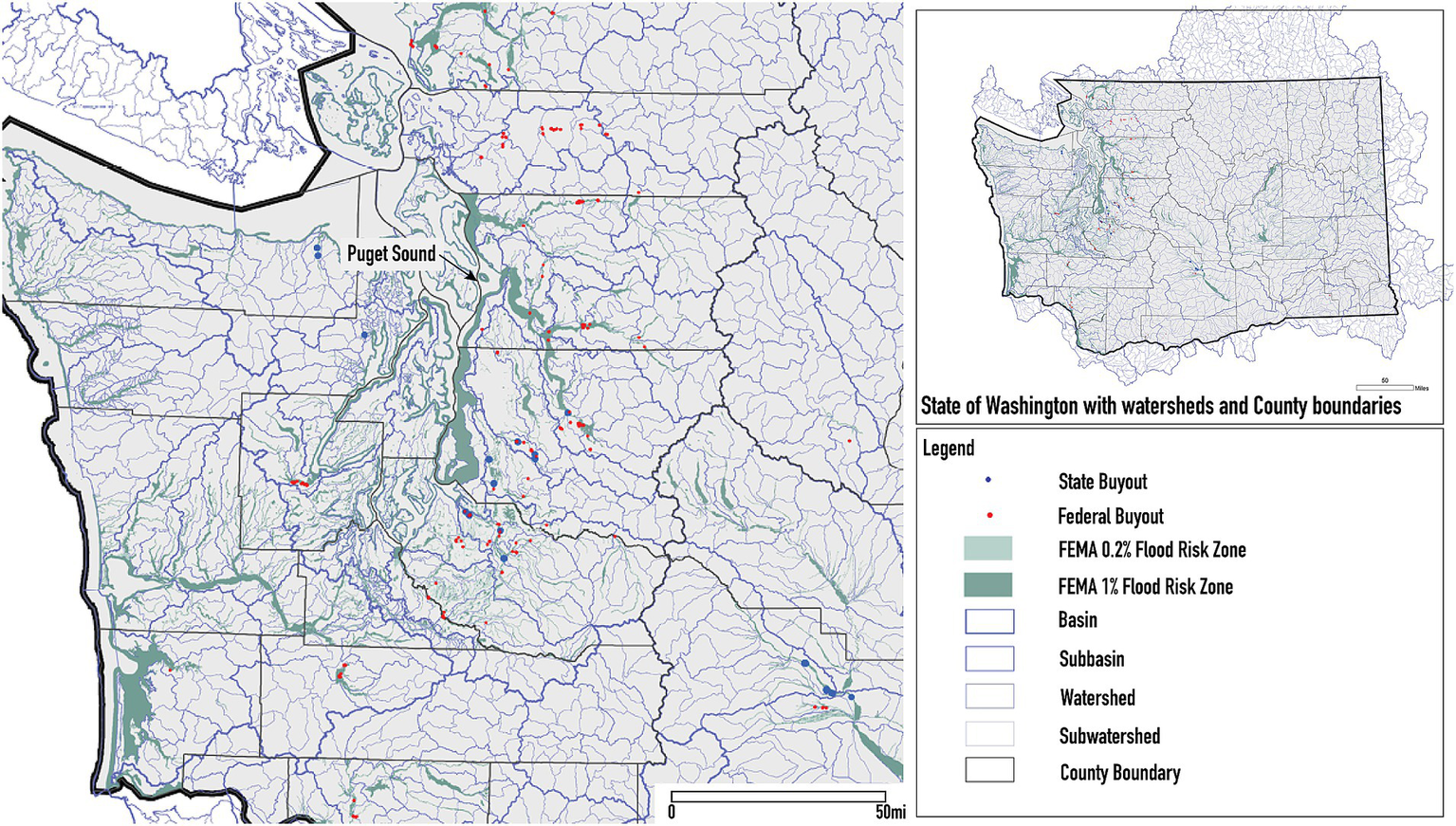
Map of Washington State’s watersheds, waterways and flood risk zones.
Floodplains by Design (FbD) is a public-private partnership led by the State Department of Ecology (current and past founders and funders include The Nature Conservancy, Puget Sound Partnership, U. S. Environmental Protection Agency, USGS, National Oceanographic and Atmospheric Administration, and Bonneville Environmental Foundation) and allies with Tribes, farmers, and local governments. It aims to improve flood protection, conserve and restore salmon habitat, preserve farmland, improve water quality and enhance outdoor recreation by re-establishing floodplain functions in Washington’s major river corridors. Established in 2013, FbD is not a buyout program but an effort to integrate and accelerate restoration and flood risk reduction efforts statewide using diverse strategies, including buyouts. FbD is a competitive grant program providing local governments and Tribes with capital funds for large-scale flood mitigation and habitat restoration projects. It promotes the concept of integrated floodplain management, “a holistic and collaborative approach to decision making that brings together multiple interests to find common agreement on local floodplain visions, strategies, and actions that achieve multiple benefits” (The Nature Conservancy, 2016). Given the program’s goals, restoration that combines risk reduction with ecological goals is built into projects to protect bay habitats that support salmon and orca.
FbD’s approach to integrated floodplain management and buyout restoration are community-driven and at scale. FbD Grant Manager Scott McKinley described the shift away from piecemeal federal funding to state funding and large-scale, integrated projects: “Floodplains by Design said we’ve got to go big from the start and do it all at once, otherwise you get half-baked projects, or what we call ‘postage stamp’ restoration projects (Gibson and Kearfott, 2020). At the same time, it has had to work to reach and serve the diversity of communities across the state. For instance, while most of the parcels we examined were undeveloped lands in more rural areas, some of FbD’s more recent allocations benefit large cities and urbanized counties, as well as Tribes, rural areas, and small towns (FbD, 2024). It has also sought to delegate more autonomy to funding recipients to mitigate top-down programmatic demands that do not meet local needs.
4.6 Setting long-term goals influences land management outcomes
This study makes clear the importance of ongoing management for what happens to the land after a buyout and for establishing clear long-term goals, no matter where programs lie in the reconciliation-restoration spectrum. Floodplains by Design sets the firmest goals for ecological outcomes (restoring salmon and orca habitat) and its programmatic funding structure and monitoring and evaluation is designed to support the achievement of these goals. Buyout programs serving more urban areas like Austin and Charlotte tend to set different goals that blend ecological and recreational aspirations. The more clearly defined the goals, the more likely programs can organize the partnerships, funding, and engagement processes necessary to achieve them. We found that it is often through land management and related community conversations that clearer visions for floodplain lands are continuously negotiated.
These results demonstrate that, despite their differences, each program is making progress toward its stated goals. Table 3 provides the results of the application of our assessment framework to each programs’ buyout lands. For example, Austin, which we characterize as “community-led reconciliation,” aims to reduce flooding, erosion, and water pollution, maximize public use, and preserve natural character. Our analysis shows that Austin does indeed achieve high scores in providing amenities for people (49% of buyout land area) and riparian buffer building (52.5% of buyout land is within 350 feet of a waterway). “Preserving natural character” suggests that visual quality and esthetics are highly valued, and this is reflected in Austin’s deferral to community preferences for buyout treatments. HCFCD, which focuses on “engineering-led reconciliation,” does not have clear restoration goals but their mandate to reduce risk is reflected in high scores for removing buildings from risk zones (78.5% buyout land area,6 including 29% of buyout parcels located in the highest risk floodway zones) although conservation zoning to protect from future development in risk areas only represents 8.3%of buyout land area. Charlotte-Mecklenburg, which focuses on “creek-centered restoration,” scores well on providing amenities (46%) and parcel contiguity (96%), reflecting their goals to make floodplains community assets. A second goal to restore floodplain function can be measured by their success in restoring riparian buffers (almost 100%), which in turn creates contiguous space for greenways along creeks. Since habitat and floodplain restoration is the foundation for Washington’s FbD, it scores highly on restoration indicators, including hydrological connectivity (62.4%), riparian buffers (76.2%), parcel contiguity (86.7%), and has by far the most acreage with dynamic land cover (51.6%).
Table 3
| Austin WPD | HCFCD | CMSS | WA FbD | ||
|---|---|---|---|---|---|
| Total Buyout Parcels (#) | 1,046 | 1,543 | 389 | 438 | |
| Total Buyout area (in acres) | 261.5 | 425.6 | 176.4 | 1947.8 | |
| Indicator | |||||
| Removes building from flood risk zone | Parcels | 1,041 (99.5%) | 1,216 (78.8%) | 354 (90.8%) | 315 (71.9%) |
| Acres | 260.35 (99.6%) | 334.07 (78.5%) | 159.95 (90.7%) | 1734.26 (89%) | |
| Provides amenities for people | Parcels | 570 (55%) | 292 (18.9%) | 174 (45%) | 216 (49.3%) |
| Acres | 128.46 (49%) | 97.70 (23%) | 80.52 (46%) | 1083.03 (55.6%) | |
| Parcel is covered by management plan | Parcels | 953 (91.1%) | 513 (33.2%) | 67 (17.2%) | 277 (63.2%) |
| Acres | 229.72 (87.8%) | 122.97 (28.9%) | 37.95 (21.5%) | 1202.4 (61.7%) | |
| Zoning reflects conservation status | Parcels | 1,046 (100%) | 60 (3.9%) | 204 (52.4%) | 55 (12.6%) |
| Acres | 261.51 (100%) | 35.27 (8.3%) | 79.11 (44.8%) | 83.7 (4.3%) | |
| Hydrologically connected | Parcels | 1,041 (99.5%) | 1,536 (99.5%) | 389 (100%) | 378 (86.3%) |
| Acres | 260.35 (99.6%) | 421.0 (98.9%) | 176.42 (100%) | 1216.31 (62.4%) | |
| Contributes to riparian buffer (100 ft) | Parcels | 194 (18.5%) | 65 (4.2%) | 319 (82%) | 112 (25.6%) |
| Acres | 78.36 (30.2%) | 32.81 (7.7%) | 154.20 (87.4%) | 928.23 (47.7%) | |
| Contributes to a riparian buffer (350 ft width) | Parcels | 425 (41%) | 715 (46%) | 387 (99%) | 208 (47%) |
| Acres | 137.30 (52.5%) | 223.02 (52.4%) | 175.84 (99.7%) | 1483.32 (76.2%) | |
| Parcels contribute to contiguity with other buyouts (within 1,000 ft) | Parcels | 1,044 (99.8%) | 1,479 (95.9%) | 381 (97.9%) | 398 (90.9%) |
| Acres | 234.47 (89.7%) | 395.67 (93%) | 169.12 (95.9%) | 1689.69 (86.7%) | |
| Parcels contribute to contiguity with conserved lands (within 1,000 ft) | Parcels | 1,046 (100%) | 78 (5.1%) | 336 (86.4%) | 115 (26.3%) |
| Acres | 261.51 (100%) | 39.85 (9.4%) | 147.52 (83.6%) | 301.36 (15.5%) | |
| Land cover is dynamic | Parcels | 67 (6.5%) | 66 (4.3%) | 62 (15.9%) | 137 (31.3%) |
| Acres | 46.04 (17.6%) | 27.93 (6.6%) | 47.20 (26.8%) | 1005.19 (51.6%) | |
Results of assessment framework applied to buyout parcels across the four case study programs.
4.7 Restoration is limited, but gaining importance
Despite progress on programmatic goals, few programs are making significant progress on restoration. Table 4 shows the results from our land cover evaluation. While our findings echo Zavar and Hagelman’s (2016) study, we find substantially more restored land cover than they did. Their study found that only 0.6% of buyout land was restored to native vegetation, while our programs (excepting Washington’s FbD) had 19% of buyout land7 in planted and volunteer vegetation including meadows, constructed wetlands and forests.8 Native vegetation is found in seeded meadows in Austin and Washington, and constructed wetlands in Charlotte-Mecklenberg. By contrast, Floodplains by Design has 88.5% of buyout land undergoing restoration. Excluding sites in Washington, lawn or lawn with trees were by far the dominant cover types (80% buyout land area). This “naturalization” is often conflated with demolition of the house and removal of impervious surface, but this does not equate to improving the ecological condition to one that reflects a floodplain’s shifting habitat mosaic, local biodiversity, land cover dynamism, and vertical layers of habitat, including understory, shrub, and canopy. Figure 6 illustrates the degree of patchiness (land cover diversity) and relative dominance of land cover types per case.
Table 4
| WA FbD | HCFCD | Austin WPD | CMSS | Cases combined acres per land cover type | Cases combined % land cover type | Cases combined – WA FbD % land cover | |
|---|---|---|---|---|---|---|---|
| Land cover | Buyout land area (in acres) | ||||||
| Lawn | 110 | 111.8 | 2.7 | 15.9 | 240.4 | 9% | 17% |
| Lawn with trees | 74.1 | 83.5 | 4.45 | 88.3 | 250.4 | 10% | 24% |
| Lawn with large trees | 12.3 | 122.3 | 170.8 | 1.5 | 306.4 | 12% | 39% |
| Meadow/Grassland | 499.7 | 2.9 | 0 | 4 | 506.6 | 20% | 1% |
| Meadow with trees | 36.6 | 0 | 44.6 | 0 | 81.2 | 3% | 6% |
| Early successional forest | 362.3 | 7.4 | 15.2 | 12.9 | 397.8 | 15% | 5% |
| Successional forest | 680.8 | 5.9 | 15.6 | 3.2 | 705.5 | 27% | 3% |
| Forest | 32.6 | 7.3 | 1.7 | 12.9 | 54.5 | 2% | 3% |
| Community garden | 12.1 | 0.6 | 1.2 | 2.9 | 16.8 | 1% | 1% |
| Constructed wetland | 0 | 0 | 0 | 8.8 | 8.8 | <1% | 1% |
| Total acres | 1820.5 | 341.7 | 256.2 | 150.3 | 2568.8 | 100% | 100% |
Land cover analysis results.
See a graphic representation of the land cover analysis in Figure 6. Parcels that still had homes were excluded from this study.
Figure 6

Land cover mosaics for each case study locations’ buyout land area. Diagrams illustrate the degree of patchiness and relative dominance of each land cover type. Note that Washington’s Floodplains by Design buyouts land area (A) is distributed more evenly across all land cover types, indicating higher land cover diversity (and more evenness) compared to Houston HCFCD buyout land (B), which is dominated by lawn land cover types.
Nevertheless, site conditions at the time of our analysis reflect both the evolving priorities of management as well as inherent contradictions between stated goals and approaches. All land managers we spoke to were well aware of the need and benefits of reducing mowing frequency and have taken steps to do so. For instance, Austin’s program increasingly advocates for best management practices, such as wildflower meadows, native grasses, and grow zones. As yet, however, 69% of its buyout sites that we studied are lawns with trees. Charlotte-Mecklenburg County strives to conduct an annual review of 5–10% of all the remaining unrestored buyout parcels to consider higher-value interim uses until longer-term plans are developed (Trautman, 2023). In Harris County, less than 14% of buyouts located within 100 feet of waterways and 4% of parcels within 350 feet are forest or successional forest, though their own “Guidance for Maintenance of Buyout Lots” (HCFCD, 2020) calls for “return to nature” areas along bayous and tributaries. While HCFCD does have tree farms and planting programs, a lack of reforested parcels along bayous may be in part due to guidelines limiting woody vegetation on levees and the banks of engineered channels (USACE, 2014). Finally, although Washington’s FbD is going a long way to restore floodplains, whether these lands will be actively managed to ensure long-term success is a significant question. The program’s Director Kaz Guillozet called management “ulcer festering,” because plans for long-term management are not required in funding applications and FbD staff are left to hope that municipalities have the capacity to do it (Guillozet, 2023; Figure 7).
Figure 7

Results of indicators applied across the four case study program buyouts. Bars measure % buyout area (in acres) scoring ‘1’ for each indicator compared to overall buyout area (in acres).
4.8 Community and multi-stakeholder involvement and responsiveness deepen both ecological and social repair
Compared to their restoration efforts, programs paid far greater attention to community needs. Around half of buyout parcels in Austin (55% of all parcels), Washington (49%), and Charlotte-Mecklenburg (45%) provide public amenities, from community gardens, to trails, to fishing rights (Figure 7). Many buyout sites have an associated project-level management plan to direct ongoing maintenance for these amenities (e.g., for 88% of Austin sites, 62% of Washington sites). Recognizing that managing and restoring buyouts for public use is not within their purview, HCFCD has partnered with county precincts, the city, and the Houston Parks Board to manage a portion of buyout land and provide amenities. These actions, along with the construction of infrastructure, such as large detention basins to increase flood storage, are indicative of a reconciliation approach.
Over time, programs have developed thoughtful and patient engagement practices to help each community evaluate reconciliation and restoration options and overcome tensions and conflicts. Esthetic preferences for lawns conflict with messier habitats like successional floodplain forests or wetlands. In Austin, for instance, managers dream of restoring buyout sites to native grasslands where buffalo could one day roam, and feel constrained by the environmental preferences among remaining residents (McKinley, 2022). At the same time, they recognize that people’s mistrust reflects the multi-decadal disinvestment that some communities have suffered. Rewilding is a laudable restoration goal, but “wild” nature in lower-income communities may contribute to the perception of dereliction and decreased property values, further damaging wealth accumulation. Responding to resident concerns is therefore key to building trust and assembling the collaborations needed for more transformative projects. Volunteer days and the Civilian Conservation Corps actively engage residents in planting and management, positioning residents to better understand the intentions behind and value of restored lands while supporting their collective role as land stewards.
At an organizational level, each program achieves their goals by establishing strong partnerships with other implementation and funding partners. These partnerships present additional institutional learning opportunities, and have expanded the programs’ approaches to land management over time, resulting in their support for a wider array of ecological, social, and economic strategies, and more holistic and integrated approaches to buyout uses. As Shi et al. (2022) noted in their review, these buyout programs are standing programs, while most buyout programs are temporarily created in the aftermath of a disaster. Over time, these standing programs have built a network of partnerships with private partners and landowners, conservation organizations, federal and state agencies, and municipal and county governments that facilitate the flow of information and maps. Partnerships provide programs with more staff capacity to leverage resources, which in turn broaden the range of actions they can fund and expand buyout programs’ influence. Through their partnerships, FbD has been able to change the state’s policy and regulatory framework to streamline funding for restoration and achieve state and regional goals for habitat restoration via locally-driven projects.
4.9 Buyouts are an emergent space requiring collective conversation
At the same time, our research shows that most buyout sites are in a state of waiting. Based on our analysis, we found five common management strategies (see Figure 8), with some parcels fitting into multiple categories. There are indeed (1) lots restored, where parcels have been reforested or wetlands restored. Sometimes, these are not active restorations, but (2) lots “let go,” where nature does most of the work because maintenance has ceased or is reduced significantly to operations such as invasive species management and trash removal. These lots can change over time via ecological succession and flood disturbance. Conversely, there are (3) lots stuck in maintenance, where mowing must be continued regularly and indefinitely due to neighbor preferences or neighborhood restrictions. There are (4) lots reconciled, where green infrastructure such as shallow flood retention basins have been constructed or amenities such as parks, community gardens, trails, and greenways increase the functional capacity of former buyout parcels to provide services, such as flood water storage and recreation.
Figure 8
![Set of images showing different lots with captions describing their maintenance status and locations:1. "Lots Restored": Two lots showing flourishing greenery in Charlotte, NC and sparse vegetation in Austin, TX.2. "Lots 'Let Go'": Overgrown vegetation on lots in Houston, TX and Austin, TX.3. "Lots [Stuck] in Maintenance": Partially maintained lots in Austin, TX and Houston, TX.4. "Lots Reconciled": Human activity evident with maintained greenery in Austin, TX and Houston, TX.5. "Lots 'In Waiting'": Sparse and untended lots in Charlotte, NC and Austin, TX.](https://www.frontiersin.org/files/Articles/1530483/xml-images/fclim-07-1530483-g008.webp)
Examples of buyouts within each category of management. Representatives from each buyout program shared examples of buyouts falling into each management category. Each buyout parcel has a unique history, story following acquisition, and reasons why it is managed the way it is, such as plans in process, neighbor and community input, HOA maintenance requirements, and restoration projects.
But, interviews revealed a surprise: with the exception of Washington’s FbD, most buyouts are (5) lots in-waiting for their final purpose or “target state” to be determined. Sometimes, a plan is in place but properties, funding, and partnerships have not been fully assembled. Other times, a plan has not yet been created and the site is indefinitely in limbo. Interviewees cited numerous barriers as the cause of this limbo status: lack of funding for restoration, grants that restrict what money can be spent on, and limited staff capacity. Practically speaking, programs are reluctant to invest in more permanent restoration actions, such as tree planting, until it is known whether lots will become part of greenways, detention basins, or constructed wetlands. Hence, mowing and other impermanent measures are common because they are an effective control for invasive species and an important “cue to care” for residents living nearby. Unfortunately, mowing is also expensive, suppresses floodplain vegetal regrowth, forest succession, and other “free” restorative processes associated with many of the potential community benefits of floodplains.
5 Discussion: making progress toward restoration and reconciliation
In summary, we find that long-standing programs for floodplain home buyouts have taken important steps to steward these lands. They have embraced a range of approaches, from those that are more community versus more expert and engineer centered, those that focus on waterways to those that center habitat more holistically, and those that are oriented more toward restoration or toward reconciliation. By establishing clear goals and management plans, these programs have been able to implement policies and projects that advance social and ecological goals, monitor and assess progress, and seek out necessary partnerships to advance their goals. Restoration is still very much a work in progress, with limited on-the-ground ecological evidence to show active changes toward fully functioning floodplains. Program managers are interested in advancing greater restoration, but also face limitations in mandates, resources, and community support.
In relation to the literature, we find that deep community engagement elevated both ecological and social outcomes. While the reconciliation-restoration debate often pits social against ecological goals, this study suggests that they are mutually reinforcing. In Charlotte-Mecklenburg, CMSS surveyed residents and held charettes to understand their preferences. Community feedback directly informed CMSS’s prioritization to use buyouts to expand continuous greenways. Meanwhile, CMSS realized that greenways were increasing surrounding land values and threatening to escalate gentrification, causing them to return to communities to seek advice. Their reflectivity is more likely to engender community trust for future greenway projects. In Austin, WPD uses multiple educational tools like signage, maps, public art and an informative online presence, and also adopts federal standards for urban relocation assistance that helps people find replacement housing, thereby reducing buyout patchiness. They also work closely with community members using tools such as neighborhood planning meetings and surveys to identify desired uses and assess public concerns. This has led them to prioritize mowed buffer strips at the edge of wildflower meadows as “cues to care” (Gibson, 2023). In Washington, FbD’s integrated restoration goals are deeply intertwined with social outcomes – salmon is crucial to Indigenous peoples of the Northwest and a pillar of the state’s economy. Prioritizing ecological goals is the result of decades of contestation over dam removal, agriculture, and Indigenous rights. Conversely, the absence of deep community engagement is associated with some of the lowest restoration and reconciliation outcomes. In Houston, HCFCD’s communication with residents is usually limited to addressing community complaints (Wade, 2023). It has the lowest proportion of buyout parcels with amenities (23%) as well as the lowest proportion of sites under conservation status (8%) or with dynamic land cover (7%).
Conceptually speaking, these practices show how the reconciliation-restoration spectrum is fundamentally socially determined and that a virtuous ecological system requires attending to residents’ needs and aspirations (Shi et al., 2023). The process of how programs decide parcels’ permanent use both reflects existing social relationships and informs the long-term health of these sites and their relationship to people. The experiences of these programs highlight the importance of listening to communities first, building a relationship with them, and coming back to listen and revise repeatedly. Austin, for example, is addressing residents’ concerns about vacant lots first, and waits about a year for community members to adjust to buyout sites’ conditions before making efforts to engage in visioning processes. These practices also reflect a process of community and organizational learning and evolution to rethink what it means to “undevelop” land and remove it from capital productivity. It is also taking time for conservation organizations (including land trusts) that mostly prioritize conserving intact, rural lands to look at buyout sites as opportunities for urban ecological repair (Kodis et al., 2021). Deciding what should be done with the land takes time to understand, define, organize, and implement. In these cases it is only possible because these are standing programs, with the ability to reflect, evolve, and sustain relationships.
This study does face important limitations. The assessment framework we provide here is meant to start a conversation about how and what to evaluate as a measure of repair, specifically on floodplain sites. Indicators chosen were constrained by the use of remote data (satellite imagery and GIS data), the availability of information across all case locations, and the level of detail recorded in available datasets. Because we did not have the capacity to do fieldwork beyond ground truthing, we could not include indicators requiring substantial parcel-level fieldwork, such as increased flood water storage, percent land cover of invasive species, and vertical structure of vegetation, important measures of floodplain function and the quality of habitats. A future study could look at these factors across a sample of buyout sites in each of the categories listed in Figure 8.
6 Conclusion
As Opperman and colleagues note (p. 1), “Floodplains also present some of the best opportunities throughout the world for innovative management that reconciles human uses and environmental conservation.” While much research has focused on the lengthiness of buyout processes (on average, 5 years), this research illustrates the indefinite, open-ended nature of long-term care required for buyout sites. Their long-term management is not a transaction, like a buyout, but an ongoing negotiation reflecting education, engagement, visioning, funding, staff training, and community priorities. Buyout sites provide urban spaces for experimentation and innovation that reimagine the distinctions between conservation and development, reconciliation and restoration. Rather than manicuring urban green space for recreational uses while leaving wildlands to the fringes, cities can use buyout sites to pilot small spaces for citizen science, children’s education, nurseries, silviculture, rewilding, or other ways of living with nature representing the country’s diverse knowledge traditions. Buyout parcels can contribute to a mosaic of dynamic habitats, greenways, trails, gardens, and more. The “in waiting” status of most buyout sites reveals that most communities have yet to decide the long-term futures of this growing category of lands. This is an exciting moment where more intentional and adaptive management, including thinking holistically (across the wider floodplain) about how buyout lands can be coordinated, along with active stewardship, can challenge esthetic preferences and cultural norms and rework human-nature relations in real-time. This process can not only enhance ecological resilience but also allow for emergent, community-driven visions for the future.
State and federal governments can support these efforts by encouraging or requiring localities to set long-term management goals and funding reparative projects, monitoring, and evaluation. Above, we highlight the importance and benefits of setting clear goals and processes of engagement. Our study also reveals the challenges of trying to create ecological and social benchmarks and criteria, especially without extensive fieldwork. More research and experimentation is needed to help establish shared indicators and assess the social, environmental, and fiscal impacts of different management policies (such as ceasing to mow). FEMA can also streamline funding across conservation programs and buyout sites, so that local buyout programs can more easily access funding for repairing buyout sites.
The question of “what to do with the land” can be a healing, generative, and positive one if it is well designed and engages communities as partners in the process. Far from arguing that reconciliation or restoration is better, this study shows that both are possible together and that these strategies can mutually reinforce one another. Different goals result in diverse management and maintenance needs, costs, land cover, impacts on surrounding property value, and the wellbeing of people who have relocated or who remain. Taking a more integrated and holistic approach to prioritization means more “just buyouts” (Freudenberg et al., 2016; Brody and Highfield, 2013), where ecological goals like habitat restoration are considered alongside flood risk reduction and flood mitigation, equity and social justice, positive impacts on households and communities (Binder and Greer, 2016) at block, neighborhood, and community scales. Deepening and expanding this kind of community engagement helps avoid the trap of “pop-up and leave” restoration (Grenz and Armstrong, 2023) and places community members in the role of co-creator. In this way, buyout lands can work in service of neighbors, non-human and human, rivers, forests and wetlands, and our own health and wellbeing through an ethic of care and repair (Samuelson et al., 2023).
Statements
Data availability statement
The raw data supporting the conclusions of this article will be made available by the authors, without undue reservation.
Author contributions
JV: Conceptualization, Data curation, Investigation, Methodology, Supervision, Visualization, Writing – original draft, Writing – review & editing. LS: Conceptualization, Funding acquisition, Project administration, Supervision, Writing – original draft, Writing – review & editing. CH: Conceptualization, Project administration, Supervision, Writing – review & editing.
Funding
The author(s) declare that financial support was received for the research and/or publication of this article. This work was supported by the Cornell Atkinson Center for Sustainability and The Nature Conservancy.
Acknowledgments
Christine Shephard, PhD (Director of Science, Gulf of Mexico, The Nature Conservancy) provided her expertise to help us develop methods, establish indicators, assess results and co-mentor research assistants. We are grateful to program and land managers who graciously shared their time and expertise with us, to Mali’o Kodis (at the time with Environmental Defense Fund) for her contributions, including organizing the research project, and to Cornell University graduate research assistants who worked on mapping and ground truthing this project: Hoi Grace Lam, Matthew Nakamoto, Nicole Nomura, Hannah Wilson, and Wenjie Zhang.
Conflict of interest
The authors declare that the research was conducted in the absence of any commercial or financial relationships that could be construed as a potential conflict of interest.
Generative AI statement
The authors declare that no Gen AI was used in the creation of this manuscript.
Publisher’s note
All claims expressed in this article are solely those of the authors and do not necessarily represent those of their affiliated organizations, or those of the publisher, the editors and the reviewers. Any product that may be evaluated in this article, or claim that may be made by its manufacturer, is not guaranteed or endorsed by the publisher.
Footnotes
1.^ The sources and descriptions of the GIS datasets used in our study can be found in supplemental data.
2.^ Not all buyouts occur within the SFHA. This is usually because of outdated mapping or mapping limitations associated with models that do not account for streams and creeks, or because the buyout was triggered by damage not from overbank river flooding but a flash flood or levee failure.
3.^ Vertical connectivity (from subsurface to surface and the reverse) is also a critical measure (Poole et al., 2008), but we were not able to measure it with data available.
4.^ Note the study done by Rempel, Austin, & Buckley was specific to the Delaware River Basin.
5.^ In a concluding set of maxims for floodplain managers, Opperman et al. include: “Floodplains need to be dynamic and diverse physically to be diverse biologically.” (p. 217).
6.^ Based on FEMA Flood Insurance Rate Maps (FIRMs).
7.^ Percentage is calculated using total acreage included in land cover analysis and excludes lands where the house has yet to be demolished.
8.^ If ecological succession is the primary mechanism of reforestation, then the tree species present are likely a mix of native, non-native, and potentially invasive species.
References
1
Adelsman H. Ekrem J. (2012). Preparing for a changing climate: Washington State’s integrated climate response strategy. Washington Department of Ecology, Report #12–01-004. Available online at: https://apps.ecology.wa.gov/publications/summarypages/1201004.html.
2
Angelbeck B. (2024). “The Longevity of Coast Salish Presence: An Archaeological History of the Salish Sea” in Salish Archipelago: Environment and Society in the Islands within and Adjacent to the Salish Sea. ed. RapaportM. (Canberra: ANU Press), 123–148.
3
Atoba K. O. Brody S. D. Highfield W. E. Shepard C. C. Verdone L. N. (2021). Strategic property buyouts to enhance flood resilience: a multi-criteria spatial approach for incorporating ecological values into the selection process. Environ. Hazards20, 229–247. doi: 10.1080/17477891.2020.1771251
4
Baker V. R. (1977). Stream-channel response to floods, with examples from central Texas. GSA Bull.88, 1057–1071. doi: 10.1130/0016-7606(1977)88<1057:SRTFWE>2.0.CO;2
5
Baker C. K. Binder S. B. Greer A. Weir P. Gates K. (2018). Integrating community concerns and recommendations into home buyout and relocation policy. Risk Hazards Crisis Public Policy9, 455–479. doi: 10.1002/rhc3.12144
6
Beechie T. J. Sear D. A. Olden J. D. Pess G. R. Buffington J. M. Moir H. et al . (2010). Process-based principles for restoring river ecosystems. Bioscience60, 209–222. doi: 10.1525/bio.2010.60.3.7
7
Beeson C. Doyle P. (1995). Comparison of bank erosion at vegetated and non-vegetated channel bends. J. Am. Water Resour. Assoc.31, 983–990. doi: 10.1111/j.1752-1688.1995.tb03414.x
8
Besterman A. F. Jakuba R. W. Ferguson W. Brennan D. Costa J. E. Deegan L. A. (2022). Buying time with Runnels: a climate adaptation tool for salt marshes. Estuar. Coasts45, 1491–1501. doi: 10.1007/s12237-021-01028-8
9
Bilkovic D. M. Mitchell M. M. LaPeyre M. K. Toft J. D. (2017). Living shorelines: the science and management of nature-based coastal protection. Boca Raton, FL: CRC Press/Taylor and Francis Group.
10
Binder S. B. Greer A. (2016). The devil is in the details: linking home buyout policy, practice, and experience after Hurricane Sandy. Polit. Gov.4, 97–106. doi: 10.17645/pag.v4i4.738
11
Binder S. B. Ritchie L. A. Bender R. Thiel A. Baker C. K. Badillo E. et al . (2020). Limbo: the unintended consequences of home buyout programmes on peripheral communities. Environ. Hazards19, 488–507. doi: 10.1080/17477891.2020.1714537
12
Brody S. D. Highfield W. E. (2013). Open space protection and flood mitigation: a national study. Land Use Policy32, 89–95. doi: 10.1016/j.landusepol.2012.10.017
13
Browne M. J. Dehring C. A. Eckles D. L. Lastrapes W. D. (2019). Does National Flood Insurance Program participation induce housing development?J. Risk Insur.86, 835–859. doi: 10.1111/jori.12240
14
Catawba Nation . (2025). About the nation. Available online at: https://www.catawba.com/about-the-nation?utm (Accessed February 21, 2025).
15
Christin Z. Kline M. (2017). Why we continue to develop floodplains: examining the disincentives for conservation in federal policy. White Paper. Earth Economics, Tacoma, WA.
16
City of Austin . (2021a). Watershed protection department annual report fiscal year 2021. Available online at: https://www.austintexas.gov/sites/default/files/files/Watershed/brochures/AnnualReport_2021_Official_Final_Interactive.pdf (Accessed March 21, 2023).
17
City of Austin . (2021b). City of Austin Watershed Protection Department Hazard Mitigation Plan, Update 2021. Available online at: https://www.austintexas.gov/sites/default/files/files/HSEM/City%20of%20Austin%20HMAP%20Update-9.15.2021-9.14.2026-PUBLIC%20COPY.pdf (Accessed November 1, 2023).
18
City of Austin . (2023a). Floodplain Management. Available online at: https://www.austintexas.gov/department/floodplain-management (Accessed March 21, 2023).
19
City of Austin . (2023b). Watershed Protection Department. Available online at: https://www.austintexas.gov/department/watershed-protection/about (Accessed March 21, 2023).
20
City of Austin . (2024). Austin Civilian Conservation Corps. Available online at: https://www.austintexas.gov/department/austin-civilian-conservation-corps (Accessed February 6, 2025).
21
CMSS . (2021a). Sustainable stormwater management strategy for a thriving city. Charlotte-Mecklenburg Stormwater Services. Available online at: https://www.charlottenc.gov/files/sharedassets/city/v/1/services/stormwater/documents/about-us/charlottestormwaterservicesstrategicplanapril2021.pdf (Accessed February 17, 2025).
22
CMSS . (2021b). Flood risk assessment and reduction community guidebook. Charlotte-Mecklenburg Stormwater Services. Available online at: https://www.dhs.gov/sites/default/files/publications/rarr_cmntygdbkfinal_clean_ms4-508c.pdf (Accessed October 21, 2024).
23
Coelho D. Hughes S. J. Varandas S. Vitor Cortes R. M. (2014). Conservation Benefits of Riparian Buffers in Urban Areas: The Case of the Rio Corgo (North Portugal). Fundam. Appl. Limnol.185, 55–70. doi: 10.1127/fal/2014/0589
24
Colding J. (2007). Ecological land use complementation for building resilience in urban ecosystems. Landsc. Urban Plan.81, 46–55. doi: 10.1016/j.landurbplan.2006.10.016
25
Costanza R. d’Arge R. de Groot R. Farber S. Grasso M. Hannon B. et al . (1997). The value of the world’s ecosystem services and natural capital. Nature387, 253–260. doi: 10.1038/387253a0
26
Crimmins A. R. Avery C. W. Easterling D. R. Kunkel K. E. Stewart B. C. Maycock T. K. (2023). Fifth National Climate Assessment. Washington, DC: U.S. Global Research Change Program.
27
Dunne T. Leopold L. (1978). Water in environmental planning. San Francisco: W.H. Freeman and Company.
28
Elias M. Joshi D. Meinzen-Dick R. (2021). Restoration for whom, by whom? A feminist political ecology of restoration. Ecol. Restor.39, 3–15. doi: 10.3368/er.39.1-2.3
29
Elliott J. R. Brown P. L. Loughran K. (2020). Racial inequities in the federal buyout of flood-prone homes: a nationwide assessment of environmental adaptation. Socius6:439. doi: 10.1177/2378023120905439
30
Elliott J. Loughran K. Brown P. L. (2021). Divergent residential pathways from flood-prone areas: how neighborhood inequalities are shaping urban climate adaptation. Soc. Probl.70, 869–892. doi: 10.1093/socpro/spab059
31
Farge K. W. (2018). Passive restoration of forest structure and composition in bottomland hardwood forests in Texas. Nat. Areas J.38, 168–182. doi: 10.3375/043.038.0207
32
FbD . (2024). 2025–2027 floodplains by design grant program ranked list. Floodplains by Design. Available online at: https://floodplainsbydesign.org/about/grant-opportunities/.
33
FEMA . (2020). Ecosystem service benefits in benefit-cost analysis for FEMA’s mitigation programs policy. FEMA policy FP-108-024-02. Federal Emergency Management Agency. Available online at: https://www.fema.gov/sites/default/files/2020-09/fema_ecosystem-service benefits_policy_september-2020.pdf (Accessed October 12, 2024).
34
FEMA . (2024). Nature-based solutions: a guide for floodplains and wetlands. Washington, DC: Federal Emergency Management Agency. Available online at: https://www.fema.gov/sites/default/files/documents/fema_nature-based-solutions-guide_floodplains-and-wetlands_december2024.pdf (Accessed March 27, 2025).
35
First Street Flood Lab . (2024a). Available online at: https://firststreet.org/city/houston-tx/4835000_fsid/flood (Accessed October 21, 2024).
36
First Street Flood Lab . (2024b). Available online at: https://firststreet.org/county/mecklenburg-county-nc/37119_fsid/flood. Accessed 10/21/2024.
37
First Street Flood Lab . (2024c). Available online at: https://firststreet.org/county/skagit-county-wa/53057_fsid/flood (Accessed October 21, 2024).
38
Freudenberg E. Tolkoff L. Brawley D. (2016). Buy-in for buyouts: the case for managed retreat from flood zones. Policy focus report #PF047. Cambridge, MA: Lincoln Institute of Land Policy.
39
Gann G. D. McDonald T. Walder B. Aronson J. Nelson C. R. Jonson J. et al . (2019). International principles and standards for the practice of ecological restoration. Restor. Ecol.27:35. doi: 10.1111/rec.13035
40
Gebrekidan B. H. Heckelei T. Rasch S. (2020). Characterizing farmers and farming system in Kilombero Valley floodplain, Tanzania. Sustain. For.12, 1–21. doi: 10.3390/su12177114
41
Gelo D. J. (2000). Comanche land and ever has been: a native geography of the nineteenth-century Comancheria. Southwest. Hist. Q.103, 273–307.
42
Gibson L . (2023). Interview with Jamie Vanucchi and Carri Hulet [Zoom], 19 May.
43
Gibson L. Kearfott P . (2020). Interview with John Tanis and Linda Shi [Zoom]. 4 August.
44
Greater Houston Community Foundation . (2025). Renewable energy and climate change in Houston. Available online at: https://www.understandinghouston.org/topic/environment/climate-change#extreme_precipitation (Accessed February 9, 2025).
45
Grenz J. Armstrong C. G. (2023). Pop-up restoration in colonial contexts: applying an indigenous food system lens to ecological restoration. Front. Sustain. Food Syst.7:790. doi: 10.3389/fsufs.2023.1244790
46
Guillozet K . (2023). Interview with Jamie Vanucchi and Carri Hulet [Zoom], 10 July.
47
Hallegatte S. Bangalore M. Bonzanigo L. Fay M. Kane T. Narloch U. et al . (2016). Shock Waves: Managing the Impacts of Climate Change on Poverty. World Bank.
48
Hasselquist E. M. Polvi L. E. Staaf R. Winkowska M. Hofman R. B. Kuglerová L. (2024). The role of riparian buffer width on sediment connectivity through windthrow in a boreal headwater stream. Geomorphology461:320. doi: 10.1016/j.geomorph.2024.109320
49
Hauer F. R. Locke H. Dreitz V. J. Hebblewhite W. H. Lowe C. C. Muhlfeld C. R. et al . (2016). Gravel-bed river floodplains are the ecological nexus of glaciated mountain landscapes. Sci. Adv.2:26. doi: 10.1126/sciadv.1600026
50
HCFCD . (2020). Guidance for maintenance of buyout lots. Available online at: https://www.hcfcd.org/Portals/62/Home-Buyout-Program/FINAL%20Guidelines%20for%20Maintenance%20of%20Buyout%20Lots_20200305a.pdf?ver=2020-03-11-200801-467 (Accessed February 6, 2025).
51
HCFCD . (2024). Voluntary acquisition program. Available online at: https://hcfcd.dnntest.hctx.net/Activity/Additional-Programs/Property-Acquisition-Program/Voluntary-Acquisition-Program.
52
Henry A. C. Hosack D. A. Johnson C. W. Rol D. Bentrup G. (1999). Conservation corridors in the United States, benefits and planning guidelines. J. Soil Water Conserv.54, 645–650. doi: 10.1080/00224561.1999.12457290
53
Higgs E. (1997). What is good ecological restoration?Conserv. Biol.11, 338–348.
54
Higgs E. (2003). Nature by design: people, natural process, and ecological restoration. Cambridge, MA: MIT Press.
55
Hill Country Conservancy . (2025). Living in flash flood alley. Available online at: https://hillcountryconservancy.org/living-in-flash-flood-alley/ (Accessed February 3, 2025).
56
Hino M. BenDor T. K. Branham J. Kaza N. Sebastian A. Sweeney S. (2024). Growing safely or building risk?: Floodplain management in North Carolina. J. Am. Plan. Assoc.90, 50–62. doi: 10.1080/01944363.2022.2141821
57
Hobbs R. J. Higgs E. Hall C. M. Bridgewater P. Chapin F. S. III Ellis E. C. et al . (2014). Managing the whole landscape: historical, hybrid, and novel ecosystems. Front. Ecol. Environ.12, 557–564. doi: 10.1890/130300
58
International Livestock Research Institute . (2021). International Union for Conservation of Nature, Food and Agriculture Organization of the United Nations, World Wildlife Foundation, and United Nations Environment Programme and International Land Coalition. Rangelands atlas. Nairobi Kenya: ILRI. Available online at: https://www.rangelandsdata.org/atlas/sites/default/files/2021-06/Rangelands_web%20%28144%20dpi%29.pdf (Accessed March 27, 2025).
59
Juan A. Gori A. Sebastian A. (2020). Comparing floodplain evolution in channelized and unchannelized urban watersheds in Houston, Texas. J. Flood Risk Manag.13:e12604. doi: 10.1111/jfr3.12604
60
Knox R. L. Wohl E. E. Morrison R. R. (2022). Levees Don’t Protect, They Disconnect: A Critical Review of How Artificial Levees Impact Floodplain Functions. Sci. Total Environ.837:155773. doi: 10.1016/j.scitotenv.2022.155773
61
Kodis M. Bortman M. Newkirk S. (2021). Strategic retreat for resilient and equitable climate adaptation: the roles for conservation organizations. J. Environ. Stud. Sci.11, 493–502. doi: 10.1007/s13412-021-00692-3
62
Konrad C. P. (2003). Effects of urban development on floods. USGS fact sheet FS-076-03. Available online at: https://pubs.usgs.gov/fs/fs07603/pdf/fs07603.pdf.
63
Koslov L. (2016). The case for retreat. Public Cult.28, 359–387. doi: 10.1215/08992363-3427487
64
Kraan C. M. Hino M. Niemann J. Siders A. R. Mach K. J. (2021). Promoting equity in retreat through voluntary property buyout programs. J. Environ. Stud. Sci.11, 481–492. doi: 10.1007/s13412-021-00688-z
65
Kunkel K. E. Stevens S. E. Stevens L. E. Karl T. R. (2020). Observed climatological relationships of extreme daily precipitation events with precipitable water and vertical velocity in the contiguous United States. Geophys. Res. Lett.47:e2019GL086721. doi: 10.1029/2019GL086721
66
Liu Y. Yu Q. Zhou Q. Wang C. Bellingrath-Kimura S. D. Wu W. (2022). Mapping the Complex Crop Rotation Systems in Southern China Considering Cropping Intensity, Crop Diversity, and Their Seasonal Dynamics. IEEE J. Select. Top. Appl. Earth Observ. Remote Sens.15, 9584–9598. doi: 10.1109/JSTARS.2022.3218881
67
Mach K. J. Kraan C. M. Hino M. Siders A. R. Johnston E. M. Field C. B. (2019). Managed retreat through voluntary buyouts of flood-prone properties. Sci. Adv.5:995. doi: 10.1126/sciadv.aax8995
68
McKinley S . (2022). Interview with Anjali Fisher [Zoom]. 16 July.
69
McNab W. H. Avers P. E. (1994). Ecological subregions of the United States: section descriptions. Administrative publication WO-WSA-5. Washington, DC: U.S. Department of Agriculture Forest Service.
70
Miao Q. Davlasheridze M. (2022). Managed retreat in the face of climate change: examining factors influencing buyouts of floodplain properties. Nat. Hazards Rev.23:04021063. doi: 10.1061/(ASCE)NH.1527-6996.0000534
71
Michael P. S. Mwakyusa L. Sanga H. G. Mwakaje A. G. Nombo C. I. (2023). Floods stress in lowland rice production: experiences of rice farmers in Kilombero and Lower-Rufiji floodplains, Tanzania. Front. Sustain. Food Syst.7:754. doi: 10.3389/fsufs.2023.1206754
72
Naiman R. J. Décamps H. McClain M. E. (2005). Riparia: Ecology, Conservation, and Management of Streamside Communities. Amsterdam: Elsevier Academic Press.
73
Nelson K. S. Camp J. (2020). Quantifying the benefits of home buyouts for mitigating flood damages. Anthropocene31:100246. doi: 10.1016/j.ancene.2020.100246
74
North Carolina Wildlife Resources Commission . (2025). Floodplain forest: Mid-Atlantic Coastal Plain. Available online at: https://www.ncwildlife.org/cpfloodplainforestpdf/open (Accessed February 9, 2025).
75
O’Driscoll M. Clinton S. Jefferson A. Manda A. McMillan S. (2010). Urbanization effects on watershed hydrology and in-stream processes in the Southern United States. Water2, 605–648. doi: 10.3390/w2030605
76
Olinde L. Lane S. Gonzalez A. Scoggins M. (2021). Stream corridors in the Blackland Prairie. RR-21-01. City of Austin Watershed Protection Department.
77
Olson D. M. Dinerstein E. (2002). The global 200: priority ecoregions for global conservation. Ann. Mo. Bot. Gard.89, 199–224. doi: 10.2307/3298564
78
Opperman J. Galloway G. Duvail S. (2013). “The multiple benefits of river–floodplain connectivity for people and biodiversity” in Encyclopedia of biodiversity. ed. LevinS. A. (Waltham: Academic Press).
79
Opperman J. Luster R. McKenney B. Roberts M. Meadows A. (2010). Ecologically functional floodplains: connectivity, flow regime, and scale1. J. Am. Water Resour. Assoc.46, 211–226. doi: 10.1111/j.1752-1688.2010.00426.x
80
Opperman J. J. Moyle P. B. Larsen E. W. Florsheim J. L. Manfree A. D. (2017). Floodplains: Processes and Management for Ecosystem Services. Oakland, CA: University of California Press.
81
Palik B. J. Clark P. W. D’Amato A. W. Swanston C. Nagel L. (2022). Operationalizing forest-assisted migration in the context of climate change adaptation: examples from the eastern USA. Ecosphere13:260. doi: 10.1002/ecs2.4260
82
Pappas M. Platt V. B. (2021). Climate changes property: disasters, decommodification, and retreat. Ohio State Law J.82:331.
83
Peña-Martinez R. (2025). Indigenous Shoal Creek. Available online at: https://www.preservationaustin.org/news/indigenous-shoal-creek (Accessed February 21, 2025).
84
Peri C. Rosoff S. Yager J. (2017). Population in the U.S. floodplains. NYU Furman Center. Available online at: https://furmancenter.org/files/Floodplain_PopulationBrief_12DEC2017.pdf (Accessed March 25, 2025).
85
Poff N. L. Allan J. D. Bain M. B. Karr J. R. Prestegaard K. L. Richter B. D. et al . (1997). The natural flow regime. Bioscience47, 769–784. doi: 10.2307/1313099
86
Poff N. L. Zimmerman J. K. H. (2010). Ecological responses to altered flow regimes: a literature review to inform the science and management of environmental flows. Freshw. Biol.55, 194–205. doi: 10.1111/j.1365-2427.2009.02272.x
87
Poole G. C. O’Daniel S. J. Jones K. L. Woessner E. S. Bernhardt E. S. Helton A. M. et al . (2008). Hydrologic spiraling: the role of multiple interactive flow paths in stream ecosystems. River Res. Appl.24, 1018–1031. doi: 10.1002/rra.1099
88
Prach K. Durigan G. Fennessy S. Overbeck G. E. Torezan J. M. Murphy S. D. (2019). A primer on choosing goals and indicators to evaluate ecological restoration success. Restor. Ecol.27, 917–923. doi: 10.1111/rec.13011
89
Puget Sound Regional Council . (2025). Vision 2050 planning resources: coordination with tribes in comprehensive planning. Available online at: https://www.psrc.org/media/5950 (Accessed February 28, 2025).
90
Quinn T. (2010). “An environmental and historical overview of the Puget Sound ecosystem” in Puget Sound Shorelines and the Impacts of Armoring—Proceedings of a State of the Science Workshop. eds. ShipmanH.DethierM. N.GelfenbaumG.FreshK. L.DinicolaR. S. (Washington, DC: USGS).
91
Reguero B. G. Beck M. W. Bresch D. N. Calil J. Meliane I. Añel J. (2018). Comparing the cost effectiveness of nature-based and coastal adaptation: a case study from the Gulf Coast of the United States. PLoS One13:132. doi: 10.1371/journal.pone.0192132
92
Rempel A. Buckley M. (2018). The economic value of riparian buffers in the Delaware River Basin Delaware Riverkeeper Network.
93
Rosenzweig M. L. (2003). Reconciliation ecology and the future of species diversity. Oryx37, 194–205. doi: 10.1017/S0030605303000371
94
Rosgen D. (1998). The reference reach: a blueprint for natural channel design. Eng. Approaches Ecosyst. Restor.1:166. doi: 10.1061/40382(1998)166
95
Rutherford J. C. Blackett S. Blackett C. Saito L. Davies-Colley R. J. (1997). Predicting the effects of shade on water temperature in small streams. N. Z. J. Mar. Freshw. Res.31, 707–721. doi: 10.1080/00288330.1997.9516801
96
Saharia M. Kirstetter P.-E. Vergara H. Gourley J. J. Hong Y. Giroud M. (2017). Mapping Flash Flood Severity in the United States. J. Hydrometeorol.18, 397–411. doi: 10.1175/JHM-D-16-0082.1
97
Salizzoni E. Pérez-Campaña R. (2019). Design for biodiverse urban landscapes: connecting place-making to place-keeping. RiVista1, 130–149. doi: 10.13128/RV-7641
98
Samoray C. Hino M. Siders A. R. Agopian A. Mach K. (2024). Housing amenity and affordability shape floodplain development. Land Use Policy144:107216. doi: 10.1016/j.landusepol.2024.107216
99
Samuelson L. Blue B. Thomas A. (2023). Restoration as reconnection: a relational approach to urban stream repair. N. Z. Geogr.79, 107–120. doi: 10.1111/nzg.12372
100
Schindler D. Scheuerell M. Moore J. Gende S. Francis T. Palen W. (2003). Pacific salmon and the ecology of coastal ecosystems. Front. Ecol. Environ.1, 31–37. doi: 10.1890/1540-9295(2003)001[0031:PSATEO]2.0.CO;2
101
Schwab J. C. (2021). After the buyouts: managing land in the floodplain American Planning Association. Available online at: https://www.planning.org/publications/document/9213989/.
102
Sheaffer J. R. Mullan J. D. Hinch N. B. (2002). Encouraging wise use of floodplains with market based incentives. Environment44, 32–43. doi: 10.1080/00139150209605590
103
Shi L. Fisher A. Brenner R. M. Greiner-Safi A. Shepard C. Vanucchi J. (2022). Equitable buyouts? Learning from state, county, and local floodplain management programs. Clim. Chang.174:29. doi: 10.1007/s10584-022-03453-5
104
Shi L. Sylman S. Hulet C. Brenner R. M. Safi A. G. Corsi P. (2023). Integrating social and ecological considerations in floodplain relocation and restoration programs. Socioecol. Pract. Res.5, 239–251. doi: 10.1007/s42532-023-00152-y
105
Siders A. R. (2019). Social justice implications of US managed retreat buyout programs. Clim. Chang.152, 239–257. doi: 10.1007/s10584-018-2272-5
106
Siders A. R. Gerber-Chavez L. (2021). Floodplain buyouts: challenges, practices, and lessons learned. University of Delaware Disaster Research Center. Available online at: https://www.nature.org/content/dam/tnc/nature/en/documents/Buyouts_Lessons_Learned_Siders_Gerber_Chavez_TNC_Full_Report_2021.pdf (Accessed November 2, 2022).
107
Siders A. R. Keenan J. M. (2020). Variables shaping coastal adaptation decisions to armor, nourish, and retreat in North Carolina. Ocean Coast. Manage.183:105023. doi: 10.1016/j.ocecoaman.2019.105023
108
Silvis V. G. (2018). Flooding by design: a look at the National Flood Insurance Program. Risk Hazards Crisis Public Policy9, 82–99. doi: 10.1002/rhc3.12131
109
Sperl J. (2022). FEMA’s disaster relief fund: budgetary history and projections. Available online at: www.cbo.gov/publication/58420.
110
Spidalieri K. Ghosh S. Zhou L. Gignoux N. Elliot J. McCormick K. et al . (2022). Greaxing resilience at home: Mecklenburg County, North Carolina: Charlotte-Mecklenburg storm water services, risk assessment/risk reduction (RARR) tool. Georgetown Climate Center. Available online at: https://www.georgetownclimate.org/files/Louisiana%20Regional%20Vision/Greauxing_Resilience_Mecklenburg_County.pdf.
111
Standish R. J. Hobbs R. J. Mayfield M. M. Bestelmeyer B. T. Suding K. N. Battaglia L. L. et al . (2013a). Resilience in ecology: abstraction, distraction, or where the action is?Biol. Conserv.158, 3–10. doi: 10.1016/j.biocon.2014.06.008
112
Standish R. J. Hobbs R. J. Miller J. R. (2013b). Improving city life: options for ecological restoration in urban landscapes and how these might influence interactions between people and nature. Landsc. Ecol.28, 1213–1221. doi: 10.1007/s10980-012-9752-1
113
Stanford J. A. Lorang M. S. Hauer F. R. (2005). The shifting habitat mosaic of river ecosystems. SIL Proc. 1922–201029, 123–136. doi: 10.1080/03680770.2005.11901979 1922-2010
114
Stoffers T. Buijse A. D. Geerling G. W. Jans L. H. Schoor M. M. Poos J. J. et al . (2022). Freshwater Fish Biodiversity Restoration in Floodplain Rivers Requires Connectivity and Habitat Heterogeneity at Multiple Spatial Scales. Sci. Total Environ.838:156509. doi: 10.1016/j.scitotenv.2022.156509
115
Stoner A. Hayhoe K. (2020). Climate impact assessment for the city of Houston. Available online at: https://www.houstontx.gov/mayor/Climate-Impact-Assessment-2020-August.pdf (Accessed June 24, 2024).
116
Sutton-Grier A. E. Wowk K. Bamford H. (2015). Future of our coasts: the potential for natural and hybrid infrastructure to enhance the resilience of our coastal communities, economies and ecosystems. Environ. Sci. Pol.51, 137–148. doi: 10.1016/j.envsci.2015.04.006
117
Task Force on the Natural and Beneficial Function of the Floodplain (2002). The natural and beneficial functions of floodplains: reducing flood losses by protecting and restoring the floodplain environment, a report for congress. Washington, DC: Task Force on the Natural and Beneficial Function of the Floodplain.
118
Tate E. Rahman M. A. Emrich C. T. Sampson C. C. (2021). Flood exposure and social vulnerability in the United States. Nat. Hazards106, 435–457. doi: 10.1007/s11069-020-04470-2
119
The Nature Conservancy . (2016). Vision, strategies and actions for Puget Sound major river floodplains. Available online at: https://www.floodplainsbydesign.org/wp-content/uploads/2017/07/FbD-Vision-and-Strategies-2016-report.pdf (Accessed October 12, 2024).
120
Tockner K. Lorang M. S. Stanford J. A. (2010). River floodplains as model ecosystems to test general hydrogeomorphic and ecological concepts. River Res. Appl.26, 76–86. doi: 10.1002/rra.1328
121
Tockner K. Stanford J. A. (2002). Riverine flood plains: present state and future trends. Environ. Conserv.29, 308–330. doi: 10.1017/S037689290200022X
122
Trautman T . (2023). Interview with Jamie Vanucchi and Carri Hulet [Zoom], 22 May.
123
UNDRR . (2025). Annual report 2024. United Nations Office for Disaster Risk Reduction. UNDRR.
124
United States Census Bureau . (2020a). Quick facts, Austin, Texas. Available online at: https://www.census.gov/quickfacts/fact/table/austincitytexas/LND110210 (Accessed September 20, 2024).
125
United States Census Bureau . (2020b). Quick facts, Houston, Texas. Available online at: https://www.census.gov/quickfacts/fact/table/houstoncitytexas/PST045224, (Accessed September 20, 2024).
126
United States Census Bureau . (2020c). Quick facts, Mecklenburg County, North Carolina. Available online at: https://www.census.gov/quickfacts/fact/table/mecklenburgcountynorthcarolina/PST045223 (Accessed September 20, 2024).
127
USACE . (2014). Guidelines for landscape planting and vegetation management at levees, floodwalls, embankment dams, and appurtenant structures. Engineer technical letter ETL 1110–2-583. Washington, DC: Department of the Army. Available online at: https://www.mvs.usace.army.mil/Portals/54/docs/LeveeSafety/Documents/2014-04-30_ETL_1110-2-583_Vegetation.pdf (Accessed March 27, 2025).
128
USFWS . (2021). Walking wetlands: integrating wetlands and agriculture in the upper Klamath Basin of California and Oregon. USFWS.
129
Wade J . (2023). Interview with Jamie Vanucchi and Carri Hulet [Zoom], 22 May.
130
Walls M. A. Liao Y. (2023). Flooding in the United States 102: policy and solutions. Washington, DC: Resources for the Future. Available online at: https://www.rff.org/publications/explainers/flooding-in-the-united-states-102-policy-and-solutions/ (Accessed November 8, 2024).
131
Walsh C. J. Roy A. H. Feminella J. W. Cottingham P. D. Groffman P. M. Morgan R. P. (2005). The urban stream syndrome: current knowledge and the search for a cure. J. N. Am. Benthol. Soc.24, 706–723. doi: 10.1899/04-028.1
132
Ward J. Tockner U. Arscott D. B. Claret C. (2002). Riverine landscape diversity. Freshw. Biol.47, 517–539. doi: 10.1046/j.1365-2427.2002.00893.x
133
Ward J. V. Tockner K. Schiemer F . (1999). Biodiversity of Floodplain River Ecosystems: Ecotones and Connectivity. River Research and Applications, 15, 125–139. doi: 10.1002/(sici)1099-1646(199901/06)15:1/3<125::aid-rrr523>3.0.co;2-e
134
Washington State Office of Financial Management . (2024). April 1 official population estimates. Available online at: https://ofm.wa.gov/washington-data-research/population-demographics/population-estimates/april-1-official-population-estimates. (Accessed October 21, 2024).
135
Wegner S. J. (1999). A review of the scientific literature on riparian buffer width, extent and vegetation. Office of Public Service and Outreach Institute of Ecology, University of Georgia, Athens, GA.
136
Weigelhofer G. Feldbacher E. Trauner D. Pölz E. Hein T. Funk A. (2020). Integrating conflicting goals of the EC water framework directive and the EC habitats directives into floodplain restoration schemes. Front. Environ. Sci.8:538139. doi: 10.3389/fenvs.2020.538139
137
Wing O. Bates P. Smith A. Sampson C. Johnson K. Fargione J. et al . (2018). Estimates of present and future flood risk in the conterminous United States. Environ. Res. Lett.13:034023. doi: 10.1088/1748-9326/aaac65
138
Winsemius H. C. Aerts J. C. J. H. Van Beek L. P. H. Bierkens M. F. P. Bouwman A. Jongman B. et al . (2016). Global drivers of future river flood risk. Nat. Clim. Chang.6, 381–385. doi: 10.1038/NCLIMATE2893
139
Worrall D. M. (2021). A prehistory of Houston and Southeast Texas: landscape and culture. Cocoa Beach, FL: Concertina Press.
140
Wurtzebach Z. Schultz C. (2016). Measuring ecological integrity: history, practical applications, and research opportunities. Bioscience66, 446–457. doi: 10.1093/biosci/biw037
141
Zavar E. Hagelman R. R. (2016). Land use change on U.S. floodplain buyout sites, 1990-2000. Disaster Prev Manag25, 360–374. doi: 10.1108/DPM-01-2016-0021
142
Zhang Y. Arthington A. H. Bunn S. E. Mackay S. Xin J. Kennard M. (2012). Classification of flow regimes for environmental flow assessment in regulated rivers: the Huai River basin, China. River Res. Appl.28:989. doi: 10.1002/rra1005
143
Zhou Z. Smith J. A. Yang L. Baeck M. L. Chaney M. Ten Veldhuis M.-C. et al . (2017). The complexities of urban flood response: flood frequency analyses for the Charlotte metropolitan region. Water Resour. Res.53, 7401–7425. doi: 10.1002/2016WR019997
Summary
Keywords
ecological repair, floodplain restoration, buyouts, floodplain reconciliation, land management
Citation
Vanucchi J, Shi L and Hulet C (2025) Reconciliation or restoration? The ecological futures of floodplain buyout sites. Front. Clim. 7:1530483. doi: 10.3389/fclim.2025.1530483
Received
19 November 2024
Accepted
25 June 2025
Published
28 July 2025
Volume
7 - 2025
Edited by
Charles Krishna Huyck, ImageCat (United States), United States
Reviewed by
Kelsea Best, The Ohio State University, United States
Michael Pollock, Northwest Fisheries Science Center, NOAA Fisheries, United States
Carolien Kraan, Deltares (Netherlands), Netherlands
Updates
Copyright
© 2025 Vanucchi, Shi and Hulet.
This is an open-access article distributed under the terms of the Creative Commons Attribution License (CC BY). The use, distribution or reproduction in other forums is permitted, provided the original author(s) and the copyright owner(s) are credited and that the original publication in this journal is cited, in accordance with accepted academic practice. No use, distribution or reproduction is permitted which does not comply with these terms.
*Correspondence: Jamie Vanucchi, jlv29@cornell.edu
Disclaimer
All claims expressed in this article are solely those of the authors and do not necessarily represent those of their affiliated organizations, or those of the publisher, the editors and the reviewers. Any product that may be evaluated in this article or claim that may be made by its manufacturer is not guaranteed or endorsed by the publisher.