 Carla Jaimes-Betancourt1*
 Geraldine Fernandez1
 Myrtle P. Shock2
 Hortensia Nina3
 Henry Delgadillo4
 Gabriela Prestes-Carneiro5
 Andrea Lima3
 Vinicius M. Nunes6
 Renan Torrico7
- 1Rheinische Friedrich-Wilhelms-Universitat Bonn, Bonn, Germany
- 2Universidade Federal do Oeste do Para, Santarém, Brazil
- 3Universidad Mayor de San Andrés, La Paz, Bolivia
- 4Wildlife Conservation Society, New York, NY, United States
- 5Museum National d'Histoire Naturelle, Paris, France
- 6Universidade de São Paulo, São Paulo, Brazil
- 7Enclave, Topography Firm, Cochabamba, Bolivia
This article presents the results of interdisciplinary and collaborative research conducted around Lakes Rogaguado and Ginebra, located in the north-central sector of the Llanos de Moxos, Bolivia—an area with limited archaeological exploration but prominent in ethnohistoric accounts related to the legendary “Gran Paititi.” Through systematic surveys, excavations, analyses of ceramics, zooarchaeological and paleoethnobotanical remains, and LiDAR mapping—carried out in dialogue with Cayubaba and Movima Indigenous communities—we identified monumental earthen architecture, raised agricultural fields, complex hydraulic systems, and a remarkable diversity in the use of local fauna and flora. The data reveal at least three main phases of pre-Hispanic occupation, each with distinct spatial and chronological patterns. At the Paquío site near Lake Rogaguado, two of these phases were documented: an early occupation around AD 600, possibly contemporaneous with the San Juan site, and a later, more intensive occupation between AD 1000 and 1200. This later phase is characterized by a higher density of ceramics, faunal and botanical remains, maize-based agriculture, and an elaborate hydraulic network associated with raised fields. In contrast, at the Jasschaja site, only the third phase of occupation was identified, dated to AD 1300–1400. Located near the El Cerro site on the eastern shore of Lake Ginebra, this phase shows broader landscape modifications, a greater diversity of plant use, and reduced faunal representation, suggesting an economy increasingly focused on the intensive management of cultivated and wild plant species. These differences reflect not only specific ecological adaptations but also broader transformations in social organization, settlement dynamics, and landscape management over time. By integrating archaeological, historical, and ethnographic evidence, this study repositions this region as a key node within the political, economic, and symbolic networks of the southwestern Amazon, shaped by continuous processes of mobility and landscape modification. This research underscores the importance of interdisciplinary, multiscalar, and community-engaged approaches for reconstructing socio-environmental dynamics of the Late Holocene in the Neotropics. It also offers new insights for the recognition of biocultural heritage and the pursuit of territorial justice in rapidly changing contexts.
1 Introduction
For centuries, cultural occupations in the so-called South American lowlands have been portrayed as the antithesis of Andean civilizations. Since colonial times, rigid boundaries were drawn between these two regions, reinforced by narratives that depicted the inhabitants of the rainforest as “chunchos,” “barbarians,” or “savages” (Combès, 2022). Such narratives normalized the invisibility of Amazonian peoples' pasts, consolidating a historical hierarchy in which the Andes occupied the central place. However, current scholarship shows that these colonial boundaries obscure the realities of pre-Hispanic dynamics: for centuries, the Andean foothills functioned as a fluid corridor for the movement of people, ideas, technologies, and religious practices (Alconini, 2016; Jaimes Betancourt, 2016a).
Recent research—driven in large part by the methodological revolution brought about by LiDAR aerial scanning—has radically transformed our understanding of Amazonian landscapes (Prümers et al., 2022; Rostain et al., 2024). Vast areas of the Amazon, long considered pristine and sparsely inhabited, have revealed an extensive and enduring human footprint. In the Llanos de Moxos (Bolivia), in particular, new findings include low-density urbanism with monumental earthen mounds (Prümers et al., 2022), extensive road networks (Erickson, 2010), hydraulic infrastructure (Lombardo et al., 2025; Rodrigues, 2016; Walker, 2018), and raised agricultural fields (Walker, 2018). This body of evidence points to carefully planned forms of landscape engineering, tailored to the environmental challenges of the seasonally flooded tropics (Lombardo et al., 2013).
The case of the Rogaguado and Ginebra lakes, in the north-central area of the Llanos de Moxos, contributes new insights to this rapidly expanding picture. Despite the logistical, environmental, and conservation challenges that have historically limited archaeological research in this region—including dense vegetation, hydrological instability, and the destruction of perishable materials—preliminary investigations reveal a landscape profoundly shaped by human activity during the Late Holocene. Alongside the material evidence, ethnohistoric sources (Tyuleneva, 2007, 2018) and recent regional archaeological studies by the Grupo de Trabajo para los Llanos de Moxos (GTLM)—a multi-institutional consortium of Bolivian and international NGOs, universities, and community partners that coordinates interdisciplinary research and conservation initiatives in the region—document a long history of Movima and Cayubaba settlements (Grupo de Trabajo para los Llanos de Moxos, 2022), complemented by accounts of Chácobo presence in the early twentieth century, recorded by Erland Nordenskiöld (2002). This historical record underscores not only the ethnic mobility and cultural diversity of the region, but also the importance of approaching these processes as dynamic and constantly evolving, avoiding simplistic or linear models of territorial occupation.
In this study, we draw on the concepts of “domestication of the landscape” (Lins et al., 2015; Clement et al., 2015) and “cultural landscapes” (Erickson, 2006). The former emphasizes the long-term and cumulative transformation of environments through the intertwined actions of human and non-human agents, while the latter frames these transformed environments as large-scale anthropogenic landscapes that integrate productive, symbolic, and social dimensions. Introducing these perspectives at the outset situates our analysis within broader debates on socio-environmental transformations and Indigenous heritage in the Neotropics.
In this article, we analyze the socio-ecological landscapes of the Rogaguado and Ginebra lakes. We consider archaeological, ethnohistorical, and contemporary perspectives to provide a complete context. Our aim is to rethink how Amazonian peoples shaped their environments and how traces of their activities persist, transform, or are reinterpreted today. We argue that, even with preliminary data, this case challenges conventional scales of social complexity and environmental transformation in regions often marginalized within the dominant narratives of pre-Hispanic Amazonia.
2 Geographical and environmental context
The Llanos de Moxos constitute one of the largest floodplains in South America, characterized by an exceptionally flat topography, with elevation differences of less than 10 m across vast areas (Larrea-Alcázar et al., 2010) and dynamic river systems (Hanagarth, 1993). This geomorphology, shaped by interactions between climatic and tectonic processes throughout the Holocene, has determined both the formation of the current landscape and the conditions for human occupation in the past. These physical characteristics have been key in shaping ecological mosaics and creating the environmental settings that enabled long-term processes of landscape domestication in the region.
Studies have demonstrated that the evolution of landscapes in the Llanos de Moxos is closely linked to neotectonic processes that began in the Early Holocene (Lombardo et al., 2013; Lombardo, 2014). Particularly significant are the uplifts in the northern part of the region, associated with the so-called “Fitzcarrald Arch,” a tectonic structure whose southeast-northwest orientation has profoundly altered the region's topography and flooding regimes (Espurt et al., 2007; Lombardo, 2014; Lombardo and Grützner, 2021). Through the analysis of high-resolution digital elevation models (TanDEM-X and SRTM), Lombardo and Grützner (2021) identified at least five active faults in the northern Bolivian Amazon. Some of these faults exhibit vertical displacements of up to 20 m, leading to the inversion of paleochannel profiles, the formation of tectonic lakes, and significant river avulsions. The formation of Lakes Rogaguado and Ginebra during the Middle Holocene (~6000 BP) as a result of tectonic block movements damming ancient valleys of the Beni River paleochanel (Lombardo, 2014, p. 502), created stable lacustrine environments that later became focal points for pre-Hispanic settlement, subsistence and hydraulic engineering.
Lake Ginebra is the second-largest lake in Bolivia and the largest in the Llanos de Moxos, covering an area of 326.74 km2, followed closely by Lake Rogaguado, which spans 311.53 km2. Both lakes, central to this research, lie at an elevation of 151 m above sea level. Their genesis is directly linked to recent tectonic processes, and their immediate surroundings display a mosaic of savannas, gallery forests, grasslands, and agricultural fields (Grupo de Trabajo para los Llanos de Moxos, 2022, p. 115–120). This mosaic reflects not only natural processes but also centuries of human modification, making it a prime example of a cultural landscape in the Amazonian lowlands.
During the Scientific Expedition to the Great Lakes of Exaltación—conducted by the Grupo de trabajo para los Llanos de Moxos—several archaeological sites were surveyed in the vicinity of Lakes Rogaguado and Ginebra. Near Lake Rogaguado, and with the support of local guides from the Cayubaba Indigenous community, sites such as Isla del Tesoro, Coquinal, and Paquío were identified northeast of the lake, where building structures, surface archaeological materials, and features indicative of substantial pre-Hispanic occupation were documented. Similarly, fieldwork near Lake Ginebra, carried out with guides from the Jasschaja community of the Movima Indigenous people, revealed extensive areas of pre-Columbian settlement along the lake's southwestern shore. These preliminary findings, underscore the interplay between geological-environmental dynamics and the cultural processes that have shaped the Llanos de Moxos over millennia, providing essential background for the archaeological interpretations discussed in the following sections.
3 The land of Paititi: ethnohistorical perspectives on the Rogaguado region
The area surrounding Lake Rogaguado not only presents evidence of pre-Hispanic occupation from an archaeological perspective but also holds a prominent place in ethnohistorical literature, particularly through its association with the legendary Land of Paititi. Historian Tyuleneva (2003, 2007, 2010, 2011, 2018), based on meticulous archival research, has argued that this region may have been the historical core of this mythical land, long sought after by explorers, chroniclers, and missionaries since the sixteenth century.
The ethnohistorical sources examined by Tyuleneva suggest that the term Paititi was used in multiple ways: to refer to a territory, a river, a hill, a lagoon, and even a political figure. In all cases, Paititi is associated with ideas of prosperity, power, and the abundance of precious metals (Tyuleneva, 2010, p. 36). With the arrival of the Jesuits, the search for these “lost kingdoms” intensified. As early as 1587, Father Andrés López identified Santa Cruz as the gateway to the great kingdoms of Paititi—a “rich piece of news” that inspired numerous expeditions (Tyuleneva, 2018).
One of the most significant accounts comes from Father Agustín Zapata, who in 1693 traveled north of the Llanos de Moxos and recorded the first documented contact with the Cayubaba nation, which at the time comprised over 2,000 individuals. The leader of this confederation was known as El Gran Jefe Paititi (The Great Chief Paititi), described as a venerable elder with a long gray beard, ruling over several villages (Eguiluz, 1884 [1696], p. 34, cited in Tyuleneva, 2018, p. 133). Other chroniclers, such as Juan Recio de León, noted that the Cayubaba adorned themselves with amber necklaces, which may refer to the use of bivalve shells still present today in Lake Rogaguado (Tyuleneva, 2010, p. 42; Grupo de Trabajo para los Llanos de Moxos, 2022, p. 160).
Although there is no definitive evidence that Father Zapata reached present-day Lake Rogaguado, the missionary Nicolás Armentia was the first to explicitly associate this region with the Land of Paititi, as early as 1905 (Tyuleneva, 2018, p. 137). According to Tyuleneva, the ethnohistorical record suggests that this area was home to a densely populated society organized into large agricultural villages governed by a centralized political authority embodied in the figure of the “Gran Paititi.”
The analysis of these sources suggest that the Lake Rogaguado region, far from being a marginal periphery, held historical significance as a political and economic hub in certain periods, as reflected in colonial and missionary narratives. While the available archaeological evidence does not yet confirm a central role within broader regional structures, these symbolic and historical dimensions enrich the investigation of the currently under study and offer deeper insight into the region's cultural landscapes.
In contrast, Lake Ginebra—also known as Lake Yajchaja (Tyuleneva, 2018, p. 155)—does not appear in ethnohistorical accounts. Although it is occasionally depicted in Jesuit mission maps from 1713, it is often confused with Lake Rogaguado. Tyuleneva (2018, p. 156) suggests that this may be due to the sparse population around Lake Ginebra or Yajchaja, in contrast to the Rogaguado area, which by the eighteenth century was already known by its current name.
3.1 Nordenskiöld's testimony and recent ethnic mobility
In the early twentieth century, Swedish explorer Erland Nordenskiöld undertook an extensive journey through the Bolivian Amazon, during which he provided a detailed description of Lago Rojo Aguado, where he encountered Chácobo Indigenous populations (Nordenskiöld, 2002). Although the name he used differs slightly from the current Lago Rogaguado, the geographical correspondence is clear. In his notes, Nordenskiöld highlights the richness of the lacustrine landscape and the presence of Indigenous communities settled along its shores.
Although it is not known which side of the Rogaguado River Nordenskiöld visited, this early record is particularly significant because it contrasts with the current ethnic composition of the territory. Today, the area is officially recognized as Cayubaba territory, although according to recent field observations it is predominantly inhabited by Movima populations. This shift reflects a process of ethnic mobility and reterritorialization over the past century, likely associated with migration, displacement, territorial reorganization, and extractive pressures affecting the Chácobo people.
The ethnographic evidence gathered by Nordenskiöld not only complements the missionary sources from the seventeenth and eighteenth centuries but also helps to trace a timeline of changes in Indigenous occupation, connecting oral traditions and written history with the archaeological landscapes. In this sense, Lake Rogaguado represents a paradigmatic example of a multivocal region, where different cultures have left their imprint across both historical and pre-Hispanic periods.
3.2 Archaeological background and cultural sequence
Archaeological research northeast of Lake Rogaguado predates the recent investigations by the Grupo de Trabajo para los Llanos de Moxos (GTLM). Building on her ethnohistorical research, Vera Tyuleneva (2007) proposed correlations between colonial documentary sources and the presence of archaeological settlements, which led her to carry out surveys in 2005 as part of the “Mojos” project. During that campaign, she recorded for the first time the sites of Coquinal and Isla del Tesoro, documenting surface ceramics and structural elements, although no samples were collected.
In 2006, archaeologist Gori Echeverría conducted further fieldwork, including excavations at Coquinal, Paquío, and Isla del Tesoro (Echeverría, 2008, 2014). Small mounds were recorded at Isla del Tesoro and Coquinal, raised cultivation fields at Coquinal, and bivalve shell deposits at Paquío. Ceramics were documented both on the surface and in excavation units; however, the results were never systematically published, and no radiocarbon dates were obtained.
Despite these analytical limitations, these studies represent the first archaeological investigations in the region and laid the groundwork for the GTLM's recent fieldwork, which revisited the same sites using updated methodologies. The GTLM's research has focused particularly on sites around Lake Ginebra, which had not previously been investigated archaeologically.
Parallel research by Walker (2004, 2012, 2018) south of the tectonic lakes of Exaltación has provided key comparative data for understanding the chronology and ceramic traditions of the central-northern Llanos de Moxos. While Walker's primary focus was the study of raised agricultural fields, excavations also recovered ceramic assemblages that help contextualize regional occupation patterns.
One of these sites, El Cerro, is a forest island distinguished by a prominent rock outcrop rising approximately 40 m above the surrounding plain. Located near the Iruyañez River, about 50 km from Lake Rogaguado and 25 km from Lake Ginebra, El Cerro has been radiocarbon dated to between AD 1300 and 1500 (Walker, 2018). The ceramic assemblage from El Cerro is characterized by plates, carinated plates, bowls, and pots with thick, wide rims. Only 14% of the fragments are decorated, typically with incised or painted fine-line geometric motifs. The ceramic pastes consistently include cauxi—freshwater sponge—as a tempering material, a recurring feature in the region's archaeological contexts.
Surrounding El Cerro is an extensive system of platform fields. Research by Whitney et al. (2014) on these earthworks indicates a marked decline in the use of fire between AD 1260 and 1280, coinciding with the occupation period at El Cerro. This chronological overlap suggests a direct relationship between the settlement and its associated agricultural infrastructure.
Walker (2018) documented that these platform fields, lacking a standardized orientation, reach considerable dimensions: 1.2 km in length, 14 to 25 m in width, and approximately 40 cm in height. Both the scale of the settlement and its association with these agricultural features underscore the regional significance of El Cerro.
Another key site, San Juan, is located on the southern bank of the same river and is also surrounded by numerous raised fields. Radiocarbon dating places its occupation between AD 500 and 600 (Walker, 2011), indicating a considerably earlier settlement than El Cerro. The ceramic assemblage from San Juan demonstrates notable technical and stylistic sophistication, including fine-line pictorial decoration applied before firing, systematic use of cauxi temper, and a variety of vessel forms identified from rim fragments. These include straight-sided bowls with flat bases, thin-walled bowls, large pots, and bell-rimmed vessels known locally as sombreros. These vessels often feature repetitive geometric motifs—zigzag patterns, S-shapes, and incised or painted lines—pointing to a formal codification that remains insufficiently understood.
As at El Cerro, raised fields were identified around San Juan. However, unlike El Cerro, these agricultural earthworks appear to postdate the occupation of the settlement (Rodrigues, 2016; Rodrigues et al., 2017).
Together, these two sites serve as key chronological and stylistic reference points for understanding the cultural sequences of the north-central Llanos de Moxos. They contribute to the broader reconstruction of technological and aesthetic traditions among the groups that inhabited this region during the Late Pre-Hispanic period.
It is important to note that most archaeological research in this area has focused on agricultural earthworks. Walker (2018, p. 6) proposed a classification of these features in the Yacuma and Exaltación regions, distinguishing between two main types: ditched fields and platform fields. According to Rodrigues et al. (2017), platform fields optimize drainage through an integrated canal system, resulting in higher elevation surfaces. These fields were often built on fluvial deposits and paleochannel levees, possibly linked to ancient courses of the Beni River (Rodrigues, 2016).
In contrast, ditched fields are lower in elevation and consist of intentionally excavated ditches, with the removed soil used to slightly elevate the cultivable surface (Lombardo et al., 2011). While platform fields are the most representative earthworks in the central-northern Llanos de Moxos, the eastern sector of the region presents greater diversity and density of raised fields, which have been extensively studied by various researchers over the decades (Denevan, 1966; Erickson, 1999; Walker, 2004; Lombardo et al., 2011; Rodrigues, 2016).
4 Materials and methods
4.1 Collaborative approach and research phases
This study was carried out within the framework of collaborative archaeology, guided by ongoing dialogue with the Cayubaba and Movima Indigenous communities, who expressed a strong interest in exploring the ancient history of the archaeological sites located within their territories. In line with approaches that advocate collaborative methodologies—developing projects with flexible agendas and addressing research questions of interest and benefit to the communities involved (e.g., Colwell-Chanthaphonh and Ferguson, 2008; Smith and Jackson, 2008)—the Grupo de Trabajo para los Llanos de Moxos (GTLM) designed a research strategy that combined conventional archaeological methods with advanced technological tools, and was implemented over two field seasons.
The first season involved archaeological surveys, exploratory excavations, and aerial surveys using drone photogrammetry. The second season focused on high-resolution LiDAR scanning in three key areas around Lake Rogaguado: Coquinal, Isla del Tesoro, and Paquío. At Lake Ginebra, systematic photogrammetric surveys were conducted along the eastern shore in close collaboration with the Jasschaja community. Site selection, activity planning, and preliminary interpretations of the results were carried out in continuous coordination with community representatives.
Community collaborators assisted in planning and implementing field activities, including guiding survey routes, facilitating access to sites, and joining archaeological teams during excavations, drone flights, and LiDAR ground verification. Their contributions provided essential logistical support and local environmental knowledge that informed decisions on site selection and field strategies, and ensured that the research remained relevant to local priorities.
4.2 Prospecting, landscape recording, and excavations
Archaeological survey along the shores of both lakes involved the collection of diagnostic surface materials. Simultaneously, photogrammetric flights conducted using a Phantom 4 Pro drone flying at an altitude of 100 m, allowed for the generation of orthomosaics and high-resolution digital surface models.
During the second season, drones equipped with DJI Zenmuse L1 LiDAR sensors (recording with three returns) were flown at 100 m altitude and a speed of 10 m/s. The resulting data were processed to generate digital terrain models (DTMs) and digital surface models (DSMs), which proved essential for identifying subtle landscape features such as raised fields, platforms, canals, and mounds (Figure 1).
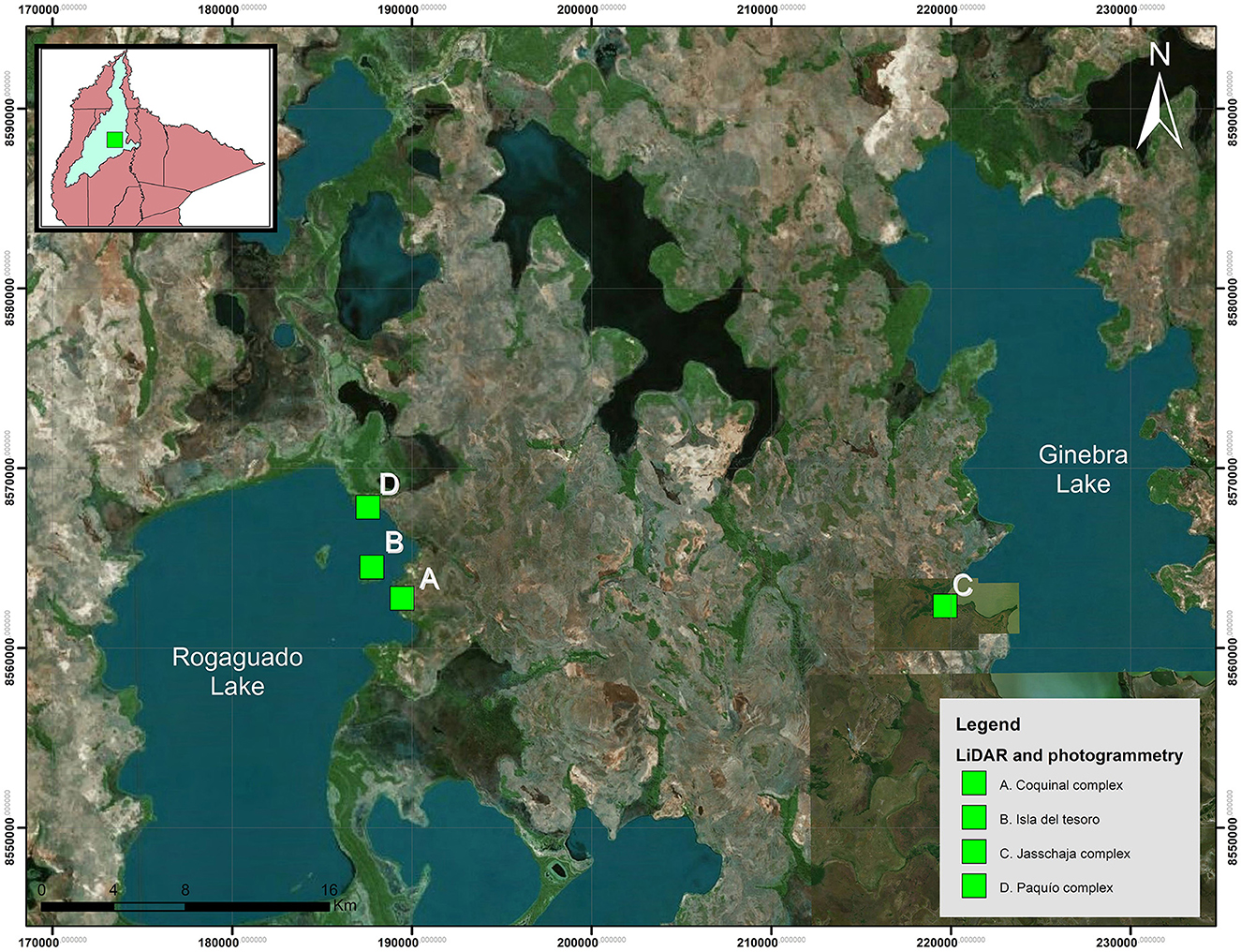
Figure 1. Photogrammetric recording area and LiDAR flight in Lakes Rogaguado and Ginebra. (Geographical reference system WGS 84).
At the Paquío site (Lake Rogaguado), a mound rich in bivalve shells and surface ceramics was selected for excavation. A 1 × 4 m test unit was excavated in arbitrary 10 cm levels. At the Jasschaja site (Lake Ginebra), a 4 × 4 m unit was opened in an area without visible surface disturbance. In both cases, excavation followed stratigraphic principles, and all finds were spatially recorded. Materials recovered included ceramic sherds, lithic artifacts, faunal remains, charcoal, and sediment samples for flotation. All materials were subsequently transferred to the laboratory for specialized analysis.
4.3 Specialized analysis of archaeological materials
The ceramic analysis followed the attribute-based methodological approach developed by Jaimes Betancourt (2012, 2015, 2016b), widely used in the construction of ceramic sequences in the Llanos de Moxos. This approach focuses on the systematic study of technological, morphological, and decorative attributes—including temper, grain size, paste structure, firing, surface treatment, vessel form, and decorative techniques—to evaluate stylistic and functional variability across sites and stratigraphic contexts.
Faunal remains were analyzed anatomically and taxonomically using specialized literature and comparative reference collections. The Number of Remains (NR), Minimum Number of Individuals (MNI), and total weight were recorded following standardized protocols (Reitz and Wing, 1999). Special attention was paid to identifying exploited species, evidence of processing (cut marks, burning, breakage), and patterns linked to subsistence practices.
Paleoethnobotanical analysis concentrated on plant macro-remains recovered through flotation (10 l per stratigraphic layer), distinguishing between woody and non-woody remains (e.g., seeds, endocarps, teguments, underground organs). Morphotypes were established, and preliminary taxonomic identification was carried out using a reference collection. For the Jasschaja site, stereoscopic microscopy (Carl Zeiss Stemi SV.11) and petrographic microscopy (Leica DM2700 P) were used for detailed examination, with magnification ns up to 500 × and photographic documentation using Leica MC170HD cameras and LAS X software.
This multiscalar methodological strategy—from regional landscape analysis to the micro-contextual study of archaeological materials—allowed for the integration of diverse lines of evidence to reconstruct occupation dynamics, environmental management, and the cultural trajectories of pre-Hispanic societies in the northeastern Llanos de Moxos.
5 Results and interpretation
Archaeological research conducted around Lakes Rogaguado and Ginebra offers new insights into the social, technological, and ecological organization of the ancient inhabitants of the north-central Llanos de Moxos from a spatially integrated perspective.
Given that both regions display significant monumental evidence, high densities of surface archaeological materials, and distinct ecological contexts, this section is organized into two major territorial units corresponding to each lake basin.
For each case, the results from landscape analysis—using LiDAR technology and aerial photogrammetry—are presented first, followed by archaeological data from excavations and the specialized analysis of ceramic, lithic, zooarchaeological, and paleoethnobotanical materials. This integrated approach not only allows the identification of local cultural patterns but also enables comparison within broader processes of settlement, environmental transformation, and socio-ecological adaptation in the Bolivian lowlands.
5.1 Archaeology of Lake Rogaguado:
Archaeological research at Lake Rogaguado focused on three primary areas: Paquío to the north, Coquinal to the south, and Isla del Tesoro, located approximately 1 km from the lake's shore (Figure 2). The proximity of these sites and the similarity of the surface archaeological materials suggest that they may have been occupied by the same cultural group. However, variations in the distribution and scale of landscape modifications may reflect topographic micro-variations and the seasonal dynamics of flooding and drought.
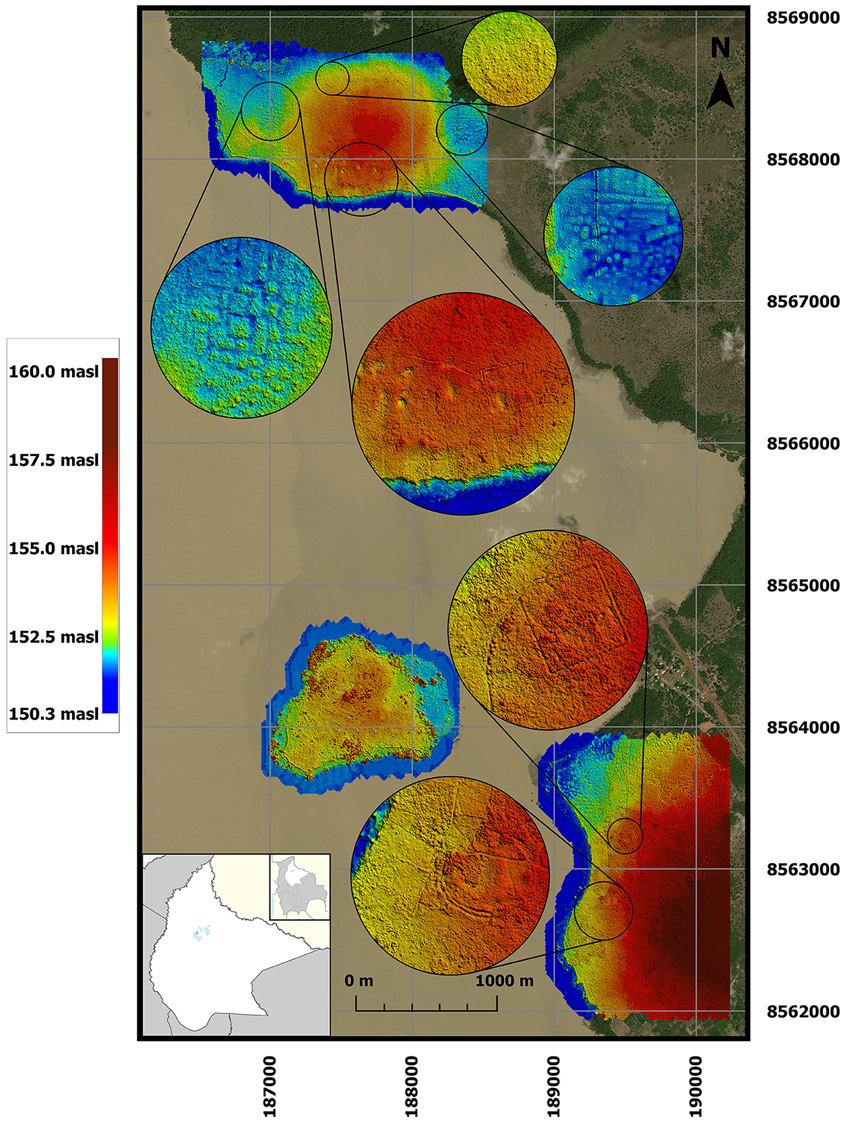
Figure 2. Three LiDAR flight areas on the north-eastern margin of Lake Rogaguado. The Paquío complex is located to the north, the Coquinal complex to the south, and Isla del Tesoro lies one kilometer from the lakeshore. (Geographical reference system WGS 84).
LiDAR surveys covered a total area of 8.6 km2, divided into three sectors corresponding to the Coquinal, Isla del Tesoro, and Paquío sites. The analysis of the Digital Terrain Model (DTM) revealed a variety of complex anthropogenic features, including ditches, platforms, canals, and raised agricultural fields.
5.1.1 Coquinal complex
In Coquinal, LiDAR identified three principal groups of earthworks (Figure 3). The first consists of a quadrangular ditch measuring 136 × 136 m, with lateral channels extending 185 to 220 m toward the lake. The ditch measures 36 cm deep and up to 5.8 m wide [Figure 3(2)].
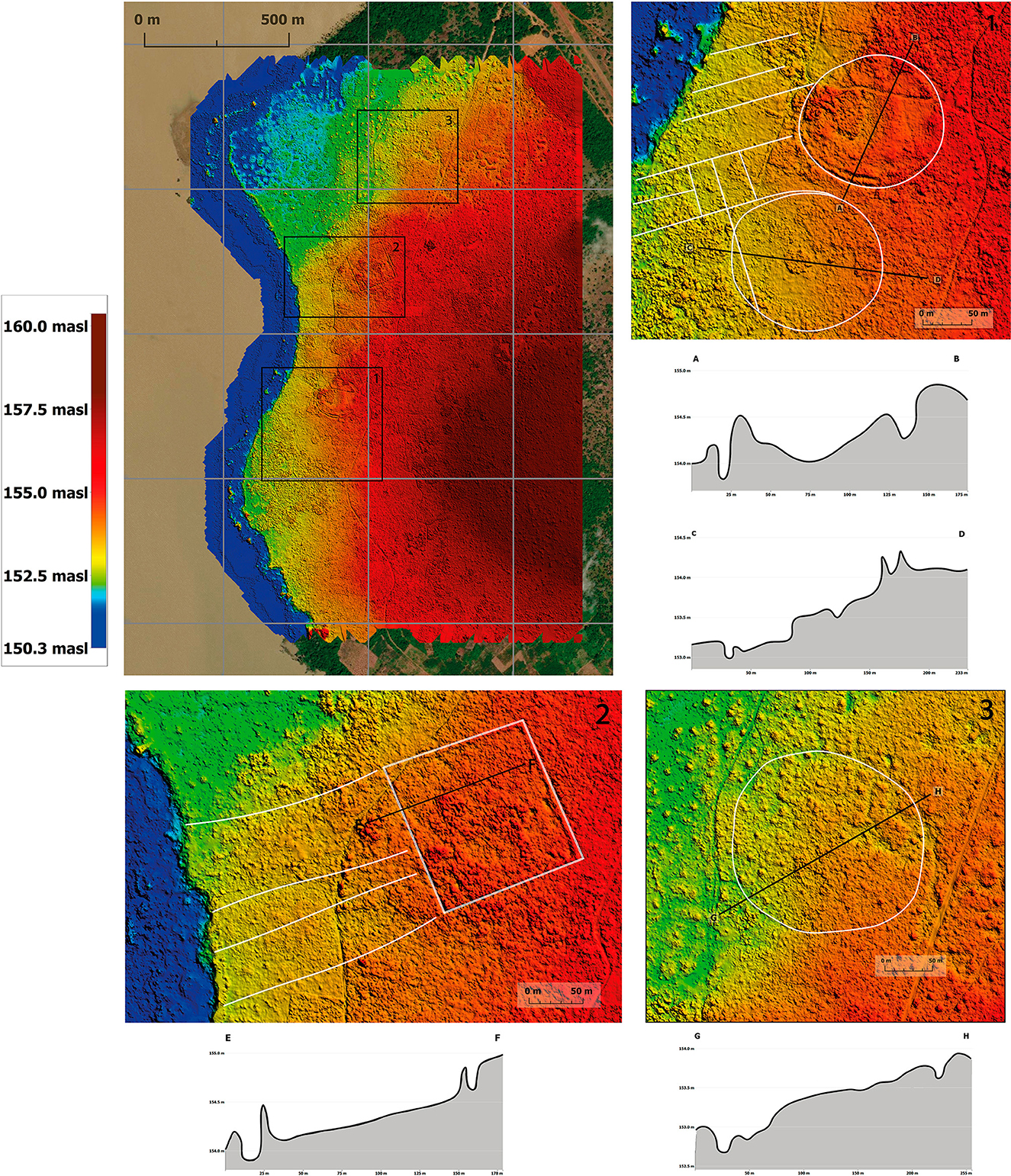
Figure 3. The LiDAR survey of the Coquinal Complex revealed three groups of earthworks: (1) To the south, two circular ditches, measuring 140 and 160 m in diameter and aligned parallel to the lakeshore; (2) in the central-west sector, a quadrangular ditch measuring 136 x 136 m; (3) to the north, a circular ditch measuring 200 m in diameter.
The second group comprises two circular ditches [Figure 3(1)], 140 m and 160 m in diameter, respectively. These structures, with embankments 20 to 34 cm high, are associated with radial channels extending up to 180 m. At the center of one ditch is a circular raised platform 26 m in diameter and 55 cm high. Both ditches are aligned parallel to the lakeshore. A third, more eroded circular ditch (200 m in diameter) is also visible to the north of the complex [Figure 3(3)].
Additionally, LiDAR surveys identified extensive areas of raised agricultural fields in low-lying flood-prone zones. To the north of the main Coquinal complex, smaller rectangular raised fields with intermediate channels up to 40 cm wide were documented. A central quadrangular platform, measuring 70 × 70 m (though eroded), appears to have served as the organizing core of this system. Further north, elongated structures up to 177 m long with internal channels reaching depths of 58 cm suggest the existence of a connected hydraulic network.
5.1.2 Isla del tesoro
On Isla del Tesoro—an island covering approximately 0.85 km2—small mounds were recorded in the central-northern area, some reaching up to 2 m in height and 17 m in length. These mounds likely correspond to those previously documented by Echeverría (2008, 2014), although erosion has made precise counting and mapping of the structures difficult (Figure 4).
Figure 4. Earthworks on Isla del Tesoro. (1) Small mounds identified in the north-central area, some reaching up to 2 m in height and 17 m in length.
5.1.3 Paquío complex
In the northern sector of the Paquío complex, two main groups of structures were identified on a natural elevation approximately 2.5 m above the surrounding floodplain. In the southern portion, a system of rectangular ditches—measuring up to 88 × 57 m—is connected by channels up to 265 m long, 8.5 m wide, and 11 cm deep. These channels are oriented north-south and descend approximately 2 m toward the lake, suggesting that they were designed to conduct and filter water in a controlled manner [Figure 5(1)].
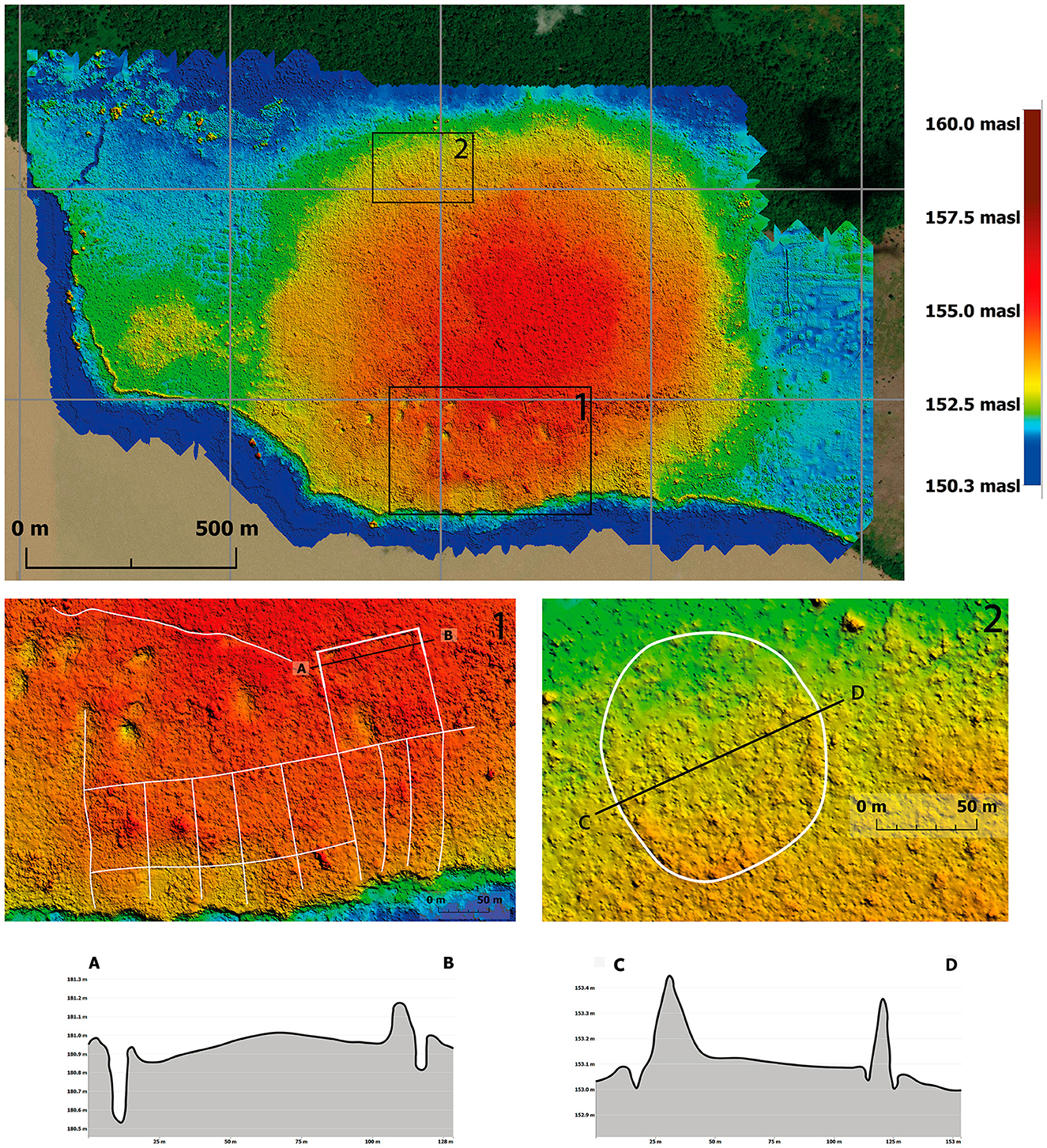
Figure 5. The LiDAR survey of the Paquío Complex revealed two groups of earthworks: (1) To the south, a rectangular ditch system connected by north-south-oriented channels that descend toward the lake, along with a 180 x 180 m quadrangular ditch. (2) to the north, in the flood zone, a circular ditch measuring 94 m in diameter.
To the southwest, a 255 m long channel—now eroded—connects to the southwest corner of the main quadrangular ditch, which measures 180 × 180 m (3.2 ha) and features double lateral embankments approximately 25 cm high and 4–5 m wide. Within this structure, four mounds of bivalve shells were identified, one of which was excavated. Further north, a circular ditch measuring 94 m in diameter, 8.5 m wide, and 25 cm high was recorded in a flood-prone area [Figure 5(2)].
Around Paquío, two extensive groups of raised agricultural fields were identified (Figure 6):
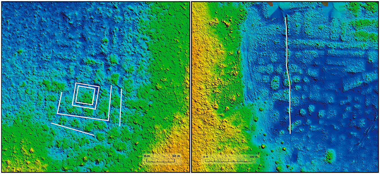
Figure 6. Raised fields on Lake Rogaguado. To the west, a quadrangular core lies at the center of a radial pattern of rectangular elevated fields. A deep channel connects this system to a nearby stream. To the east, raised fields separated by channels approximately 30 cm deep were documented, intersected by larger transverse channel.
To the west, a quadrangular core measuring 32 × 32 m forms the center of a radial pattern of rectangular elevated fields measuring 32–55 m in length, 17–22 m in width, and approximately 50 cm in height. A 40 cm deep channel connects this system to a nearby stream.
To the east, more elongated raised fields were documented, measuring 27–180 m in length and 14–19 m in width, separated by channels approximately 30 cm deep. A larger transverse channel, 60 cm deep and 2.8 m wide, cuts through this matrix.
5.1.4 Excavation and analysis of the Paquío site
Located approximately 200 m from the shore of Lake Rogaguado, the Paquío site is characterized by small mounds composed of both whole and fragmented bivalve shells, accompanied by a high density of surface pottery. The largest mound, measuring 90 cm in height and 22.5 m in diameter, was selected for the excavation of a 4 × 1 m unit oriented transversely to expose the complete stratigraphy down to a depth of 120 cm. The upper levels revealed the absence of a humus layer and significant sediment disturbance. A total of 25 features were documented, most related to refuse deposits and natural events (Figure 7).
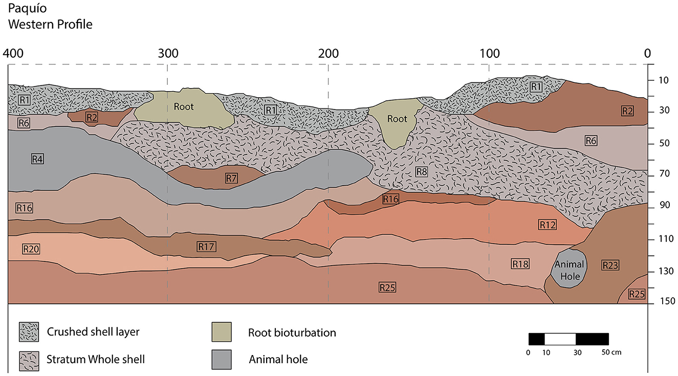
Figure 7. Stratigraphic profile – excavations at the Paquío site.
Radiocarbon dating at the Paquío site identified two distinct occupation phases: an early, brief phase around AD 600, and a longer, more intensive phase between AD 1,000 and 1,200 (Figure 8). The third phase was not documented at this site. Both occupations are associated with contexts rich in shell remains, suggesting continuity in dietary habits and technological practices over time.
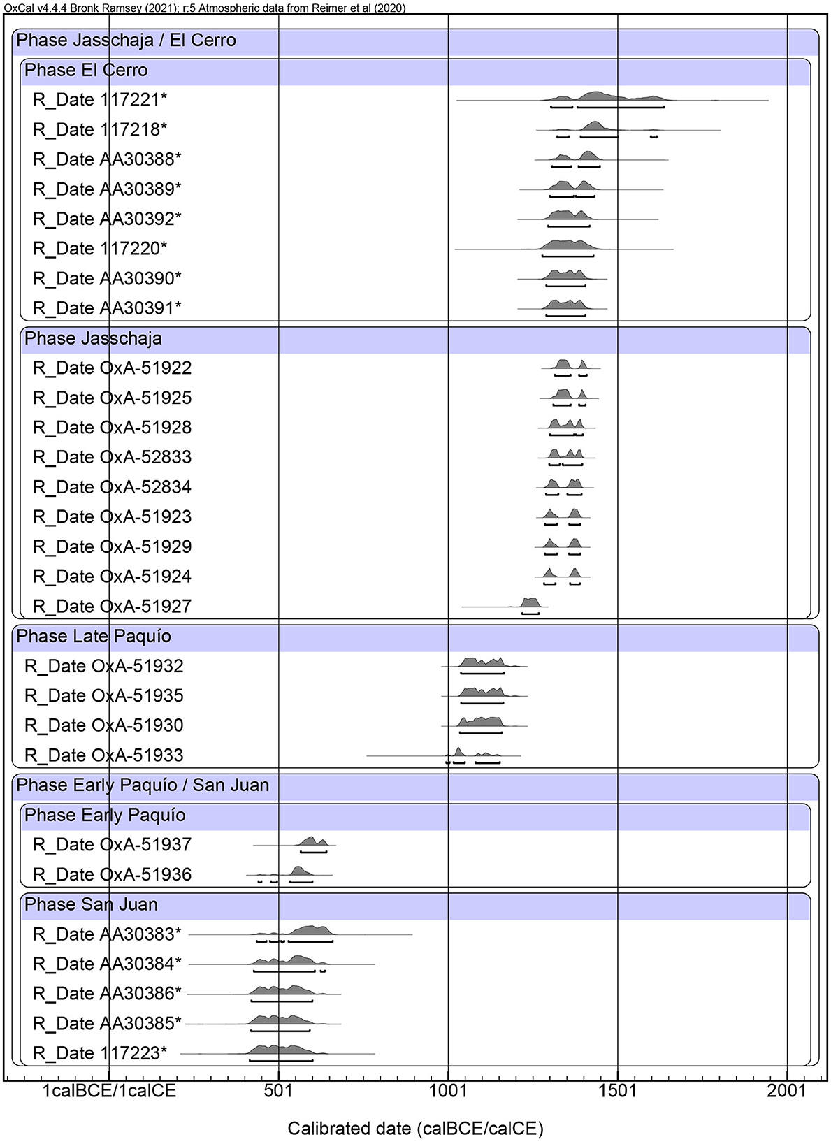
Figure 8. Chronological Sequence showing the Jasschaja Phase, Late Paquío Phase, and Early Paquío Phase. Radiocarbon dates derive from archaeological excavations at the Jasschaja and Paquío sites. As they belong to the same archaeological tradition, dates from the El Cerro and San Juan sites published by J. Walker in his 2000 article “Ceramic Assemblages and Landscape in the Mid-1st Millennium Llanos de Mojos, Beni, Bolivia,” were also considered and included in the table.
The ceramic assemblage recovered at Paquío—defined as the Paquío Complex—is composed of six paste types combining cauxi with feldspar, chamotte, caripé, or crushed ceramic. Vessel forms include open, closed, and necked types, they are predominantly undecorated and of orange, brown, and gray hues. When encountered, decorative techniques are mainly pictorial, although incised motifs were also identified, with a preference for geometric patterns such as straight and wavy lines, concentric squares, grids, and chain-like designs. Particularly notable forms are thick-walled pots, hemispherical bowls with everted rims, and vessels with internally decorated necks. Among the outstanding pieces is an almost complete trapezoidal bowl decorated with concentric square incisions (Figure 9).
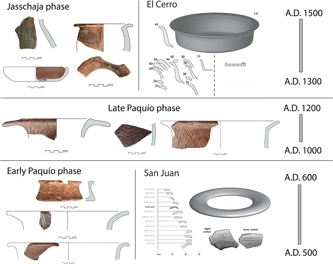
Figure 9. Ceramic styles of the north-central Llanos de Moxos. The Early Paquío Phase is similar to the San Juan Phase (AD 500 to 600) The Late Paquío Phase dates to AD 1000 - 1200, and the Jasschaja Phase is similar to the El Cerro Phase (AD 1300 to 1500). The material from the San Juan and El Cerro phases corresponds to the research of J. Walker, published in his 2018 book Island, River, and Field.
Lithic material was scarce: only two grinding stones—one made of sedimentary rock and the other of red quartzite—were recovered, along with a finely worked tembeta, suggesting specific ornamental and technological practices (Figure 10).
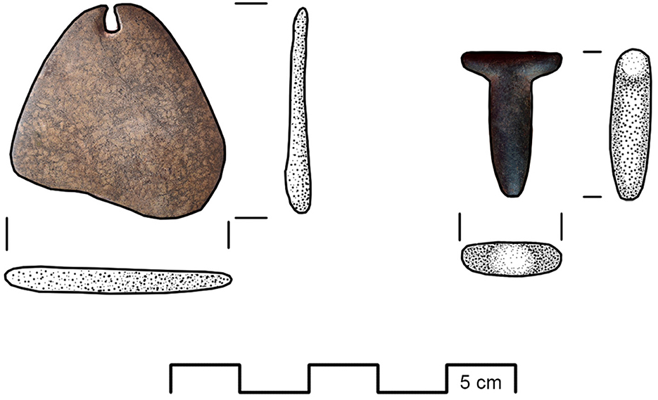
Figure 10. Pendant and tembeta: special lithics from the Jasschaja and Paquío complexes, respectively.
Zooarchaeological analysis yielded a substantial sample of 1,224 bone fragments (Number of Remains, NR) corresponding to a minimum of 1,092 individuals (MNI), distributed across six taxonomic groups. Fish were the most represented, with 12 taxa identified, including Hoplias sp., Cichla sp., Hoplosternum sp., Synbranchus spp., and Lepidosiren paradoxa [Figure 11(1)]. Reptiles such as Caiman crocodilus, snakes (Eunectes, cf. Epicrates), lacértidos and aquatic turtles (Podocnemidae) were also present [Figure 11(3)], along with mammals including rodents (Cuniculus paca, Hydrochaeris hydrochaeris), artiodactyls, armadillos and bats [Figure 11(2)]. The presence of cut marks, burning, and other evidence of processing indicates intensive exploitation of fauna, comparable to patterns observed at sites such as Loma Salvatierra and Loma Mendoza, albeit with a lower frequency of Lepidosiren (Prestes-Carneiro et al., 2019).
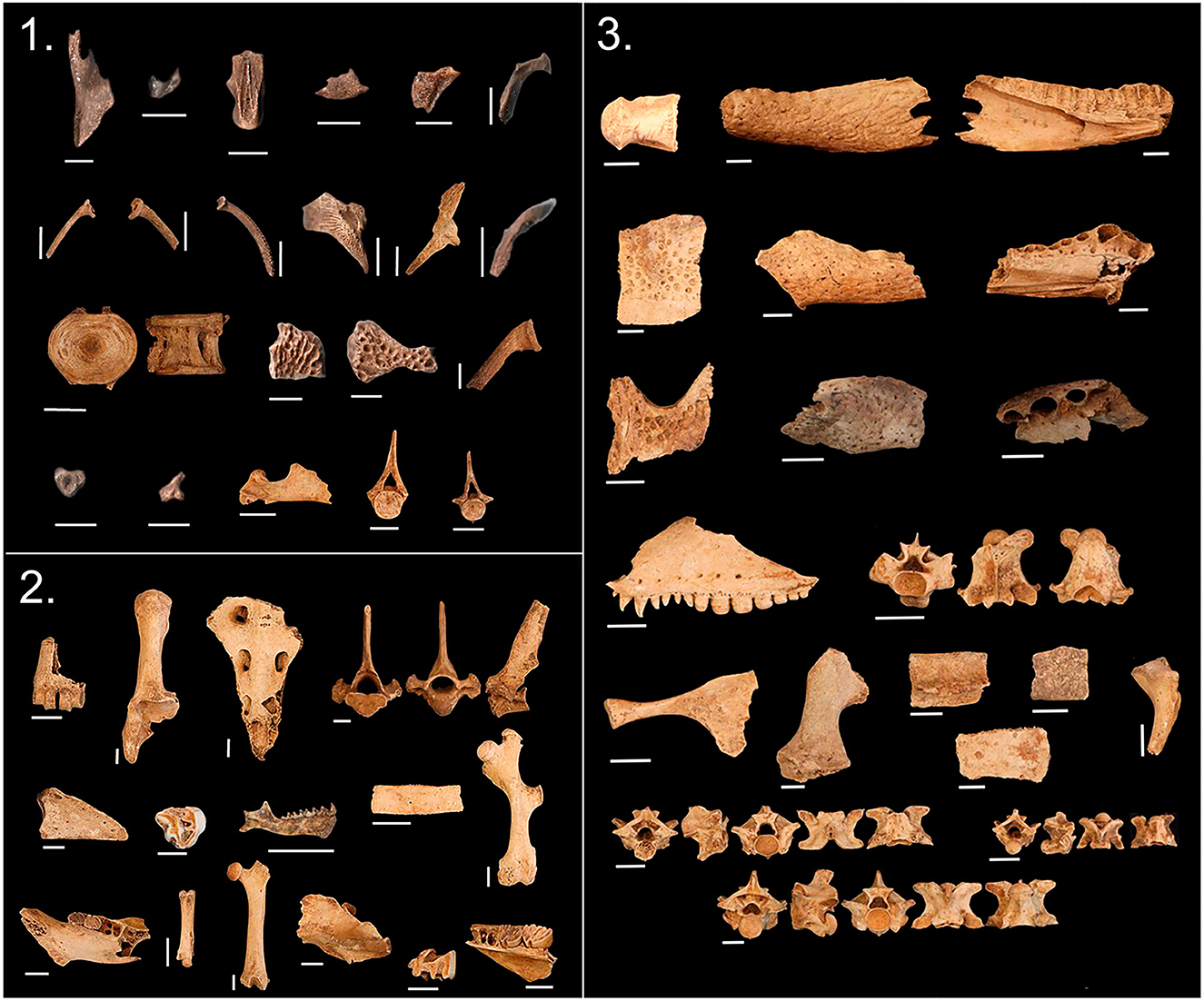
Figure 11. Osteological remains from the Paquío site: (1) fish; (2) mammals; (3) reptiles.
Paleoethnobotanical analysis revealed evidence of a mixed subsistence strategy. The sample of 1,485 macroremains was divided into non-wood (seeds, fruits and subterranean organs, 145 or 9.8%) wood (1,154 or 77.7%), monocotyledonous stems (104 or 7.0%), and non identifiable charcoal (82 or 5.5%). Remains of Zea mays (maize), palms such as Mauritia flexuosa or Mauritiella sp., Attalea sp., and Astrocaryum sp., and a species of Fabaceae were identified (Table 1). The presence of palm fruits suggests selective management of crops and other plant resources. Even without a large sample of maize, the presence of maize in the upper levels may indicate a gradual transition toward more intensive and diversified agriculture as suggested by the hydraulic technologies around the site.
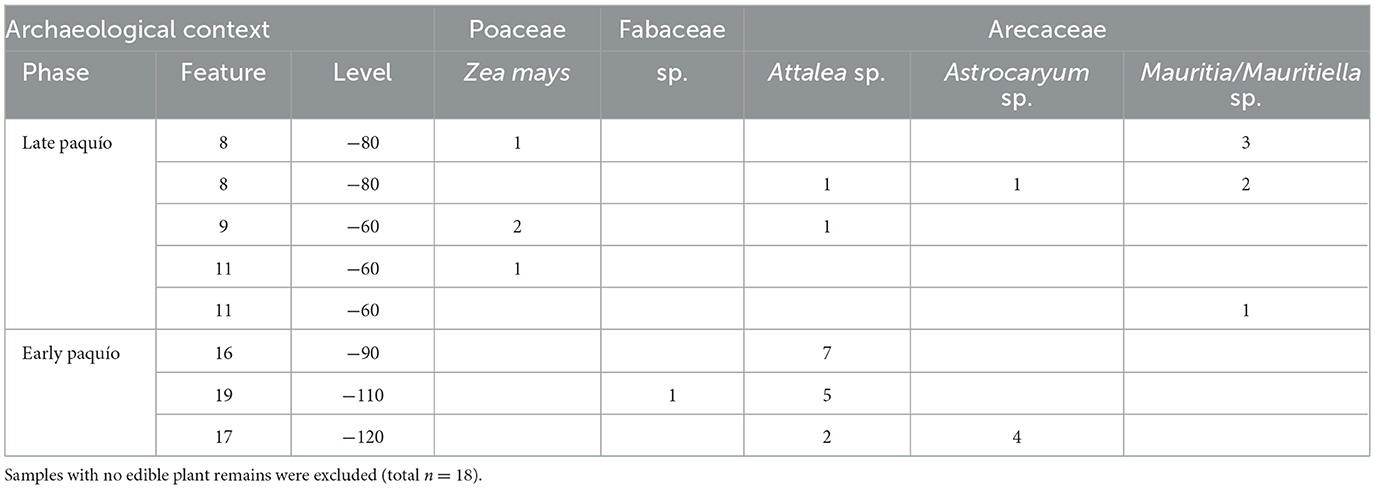
Table 1. Quantities of edible plant remains (seeds or endocarps) from charcoal samples at Paquío.
Overall, the evidence of monumentality in the earthworks, together with the long occupation history identified at Paquío suggests a domestic,—and possibly sedentary— settlement in which agriculture, the gathering of wild resources, palm management, and the systematic exploitation of aquatic and terrestrial fauna were integrated into a flexible and adaptive subsistence strategy.
5.2 Archaeology of Lake Ginebra
Research at Lake Ginebra focused on its eastern shore, specifically on the Jasschaja site and its surrounding landscape (Figure 12). This area attracted attention due to the high density of raised fields of varying shapes and sizes, as well as the abundant archaeological material observed on the surface. Aerial surveys of the Jasschaja complex revealed multiple monumental archaeological features with diverse characteristics, distributed along the lake's eastern margin.
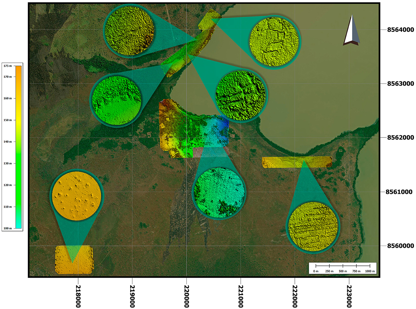
Figure 12. Flight area of the photogrammetric record of Lake Ginebra.
To document this diversity, four sectors were randomly selected for photogrammetric surveys. The first sector, located 2 km east of the Jasschaja community, covers an area of 24.6 ha where elongated earthworks—measuring up to 150 m long and 20 m wide—were documented, oriented east-west and likely exposed to seasonal flooding from Lake Ginebra.
The second sector spans 89 ha and includes the community of Jasschaja, an adjacent cultivation areas, and a northeastern zone with earthworks resembling raised agricultural platforms measuring up to 90 m in length and 6 m in width.
The third sector, 1.8 km north of Jasschaja, covers 37 ha and is characterized by large earthen structures, including quadrangular platforms measuring 54 × 48 m, surrounded by ditches up to 6 m wide and 80 cm deep. Rectangular platforms up to 47 m long, 10 m wide, and 75 cm high were also recorded, along with smaller, eroded raised fields close to the lake's floodplain. Some areas are enclosed by embankments averaging 3 m wide and 60 cm high.
5.2.1 Excavation and analysis of the Jasschaja site
The Jasschaja archaeological site, selected by the local community for excavation, is located 160 m southwest of Lake Ginebra in an area with no recent disturbance and dense surface archaeological material. A 4 × 4 m unit was excavated to a depth of 110 cm, revealing 31 features, mostly middens and domestic contexts (Figure 13). Radiocarbon dating places the site's occupation between AD 1300 and 1400 (Figure 8), making it one of the latest settlements in the regional sequence.
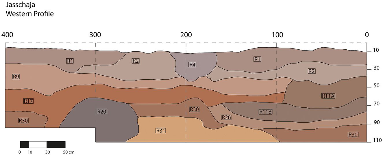
Figure 13. Stratigraphic profile of excavations at the Jasschaja site.
The ceramic assemblage—defined as the Jasschaja Complex—exhibits both continuity and innovation relative to Paquío. Eight paste types were identified: six previously recorded at Paquío, plus two additional ones. The first combines cauxí with ground stone and is typically used for open vessels and whetstones; the second combines cauxí with fine, rounded chamotte, is associated with a broader variety of forms, including open and closed vessels, necked vessels, smoothing tools, and pestles. Decorations are predominantly pictorial, with complex geometric motifs such as vertical, horizontal, oblique, wavy, and zigzag lines, as well as triangular, quadrangular, and grid patterns (Figure 9). Ceramic forms include large open vessels with everted rims and varied lips, closed vessels, and necked vessels decorated on the interior, designed to display motifs visible from the exterior.
Lithic material was limited but included a complete red quartzite grinding stone, seven quartzite cores with longitudinal or multidirectional fractures, and a fragmented pendant—interpreted as a polished necklace element—recovered at one meter depth (Figure 10), representing a unique ornamental artifact in this context.
The zooarchaeological assemblage was significantly smaller than at Paquío: only 31 highly eroded bone fragments were recovered, most of which were too small for precise taxonomic identification. The limited identifiable remains suggest the presence of mammals and birds but do not allow further interpretation of faunal exploitation.
In contrast, paleoethnobotanical analysis yielded remarkably rich results. A total of 18,962 macrobotanical remains were analyzed: 15,371 (81%) corresponded to woody material, 969 (5%) to non-woody remains, and 2,622 (13%) were unidentifiable. Variability among samples suggests heterogeneous contexts, likely linked to different domestic activities and waste deposition. When split into lower and upper layers, a range of palm species are observed in the site's earliest occupations, followed by diversification to a range of forest and crop species (Table 2). Taxonomic identification of charred plant remains (Figure 14(1–7)), includes several palm species such as Attalea sp., Astrocaryum sp., Acrocomia sp., Syagrus sp., Mauritia flexuosa or Mauritiella sp., and Bactris sp., the latter including the domesticated Bactris gasipaes (peach palm), evidenced by the presence of endocarps. Among dicotyledonous species, remains of Bertholletia excelsa (Amazonian nut) were identified, marking the first archaeological record of this species south of the Madre de Dios River. Other identified taxa include Caryocar sp. (piquiá) and Fabaceae species, possibly including Phaseolus sp. (common or lima beans). Additionally, maize (Zea mays) has been recorded as present in 3 of the features, with another 3 features containing possible maize grains.
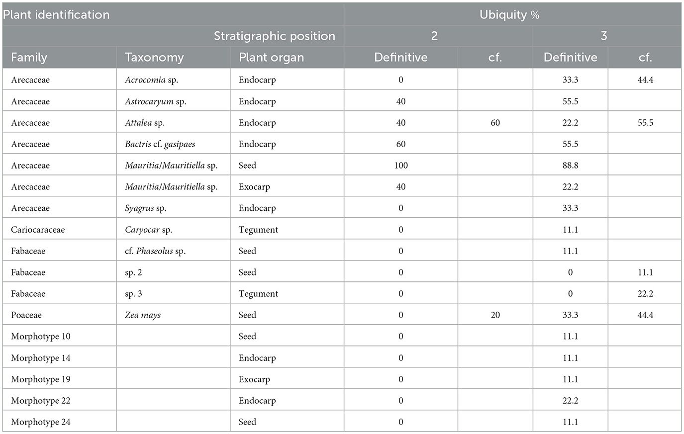
Table 2. Ubiquity of edible plant remains from charcoal samples at Jasschaja (strata 2 n = 5, strata 3 n = 9, single strata 4 sample excluded).
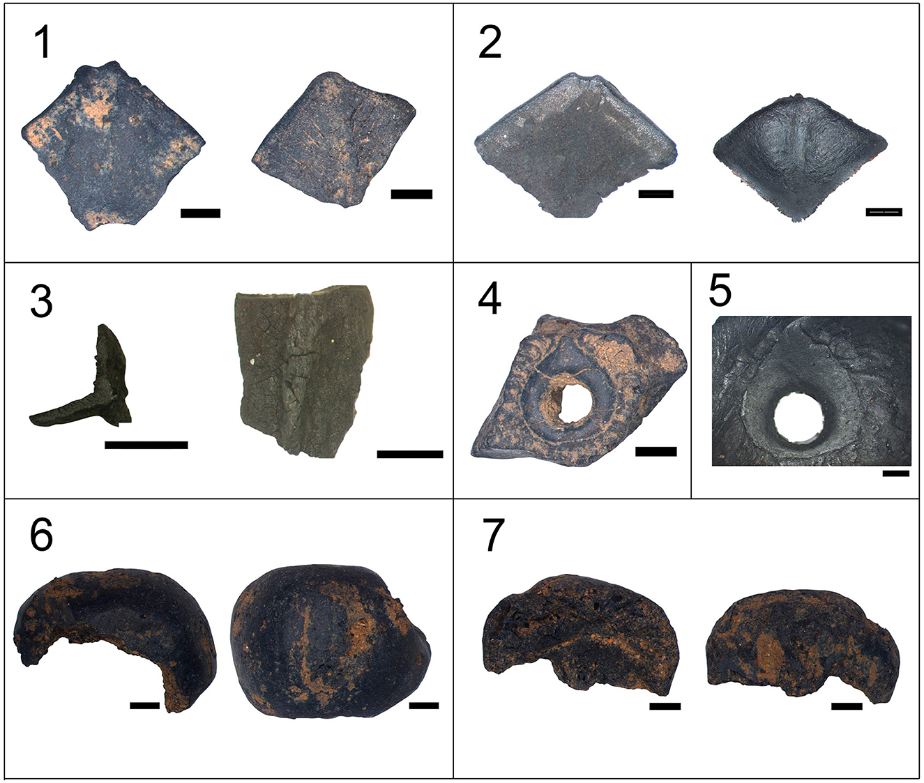
Figure 14. Carbonized macro-remains from the Jasschaja site and charcoals from the COMIDA reference collection at the Universidade Federal do Oeste do Pará, PA, Brazil, and the Jasschaja site. (1)–Exocarp of moriche (Mauritia flexuosa) from Feature 11A (specimen N° 33 and N° 38); (2)–Exocarp of moriche (Mauritia flexuosa) from the reference collection (specimen N° 1663 and N° 1662); (3)–Seed coat of Brazil nut (Bertholletia excelsa) from Feature 18 (specimen N° 109); (4)–Germination pore of totai (Acrocomia sp.) from Feature 10 (specimen N° 189); (5)–Germination pore of totai (Acrocomia sp.) from the reference collection (specimen N° 1009); (6)–Maize fragment from Feature 11A (Zea mays) (specimen N° 29); (7)–Maize fragment from Feature 11A (Zea mays) (specimen N° 31). Images were obtained using a Carl Zeiss Stemi SV.11 stereomicroscope coupled with a Leica MC170HD camera, along with LAS X software. All scale bars correspond to 1 millimeter.
The integrated results suggest that Jasschaja was a complex settlement in which agricultural practices, wild species gathering, palm management, and sophisticated ceramic production coexisted. Despite the low density of faunal remains, the botanical richness and technological diversity reflect an intensive and differentiated use of the Amazonian plant landscape in the late pre-Hispanic period.
6 Discussion
For decades, the north-central Llanos de Moxos have been perceived as peripheral to the major centers of pre-Hispanic civilization. However, the results of this study reveal a sustained socio-ecological complexity that challenges this marginalization and highlights the need to rethink the historical significance of these lowland societies. The integrated archaeological, ethnohistorical, and paleoecological evidence presented here suggests that the landscapes surrounding Lakes Rogaguado and Ginebra were not untouched wilderness, but rather long-inhabited and transformed environments shaped by centuries of human agency.
Drawing on the concept of landscape domestication (Clement et al., 2015), we argue that the monumental earthworks, raised agricultural fields, and multispecies resource management strategies identified at Paquío and Jasschaja represent not isolated innovations, but enduring processes of socio-environmental transformation. These landscapes were constructed through the cumulative actions of human communities who not only adapted to environmental variability, but actively reshaped their surroundings in ways that enhanced biodiversity, productivity, and cultural meaning.
6.1 Regional chronology and technological transformation
The comparative analysis between the sites excavated by the GTLM—Paquío and Jasschaja—and those previously studied by Walker—San Juan and El Cerro—allows us to outline a regional sequence of occupation and technological transformation spanning nearly a millennium (Table 3). This diachronic perspective reinforces the idea that the landscapes of the Llanos de Moxos are the result of cumulative human interventions over the long term, rather than isolated episodes of settlement.
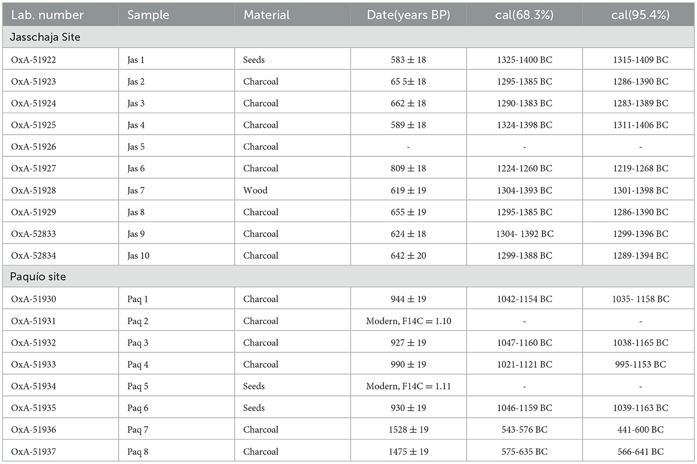
Table 3. List of C14 dates from the Jasschaja and Paquío sites.
San Juan (AD 500–600) represents the earliest phase identified, characterized by finely made ceramics with geometric motifs painted before firing, distinctive vessel forms such as sombreros, and the systematic use of cauxí as a temper. This tradition continues in the early phase of Paquío (ca. AD 600), expanding significantly in the later occupation (AD 1,000–1,200), when new paste recipes and greater formal and functional diversity appear in the ceramic repertoire, alongside increasingly sophisticated hydraulic infrastructure.
The later occupations of Jasschaja and El Cerro (AD 1,300–1,400) maintain the technological base of previous phases but introduce notable innovations. While El Cerro presents a more homogeneous ceramic assemblage with limited decoration, Jasschaja stands out for its formal complexity, the appearance of new pastes such as cauxí with ground stone, and an intensive use of pictorial ornamentation that may reflect greater symbolic elaboration or social differentiation.
These variations suggest that while certain technological traditions—such as the use of cauxí and geometric iconography—provided continuity across centuries, communities also engaged in processes of local innovation and adaptation. The diversity of forms, materials, and decorative styles speaks to the dynamic cultural landscapes of the region, shaped by changing ecological conditions, social networks, and symbolic systems.
By situating these sites within a coherent regional and chronological framework, we not only document the material expressions of long-term occupation, but also reinforce the concept of the landscape as a multivocal archive, where material culture reflects both enduring traditions and episodic transformations.
6.2 Diversified subsistence and transformations in food landscapes
Comparative analysis between the Rogaguado and Ginebra lakes reveals different patterns of land use, but also relevant continuities in subsistence strategies. In Rogaguado, the Paquío site shows a sophisticated integration of agriculture, fishing, gathering, and ceramic production, in association with complex hydraulic infrastructures. Zooarchaeological analyses show a diet based on fish, aquatic reptiles, medium-sized mammals, and birds, while paleoethnobotanical data reflect management of cultivated and wild plants—including Zea mays, palms (Mauritia flexuosa/Mauritella), and legumes—within an agroforestry system adapted to seasonal fluctuations. This model suggests a form of agriculture, possibly structured within a multi-species agroforestry system sustained over time (Levis et al., 2017; Levis, 2018). The presence of raised cultivation fields with controlled drainage channels reinforces this interpretation and points to hydraulic technologies developed to maximize productivity and environmental resilience.
In Ginebra, although the density of faunal remains is low, the paleoethnobotanical evidence from Jasschaja is exceptionally rich. Species such as Bactris gasipaes, Amazonian nut Bertholletia excelsa (first archaeological record south of the Madre de Dios River), Acrocomia sp., Astrocaryum sp., Attalea sp., Syagrus sp., Caryocar sp. and Phaseolus sp. were documented. This plant richness, coupled with ceramic diversity and tools such as grinding stones and whetstones, suggests a strategy focused on intensive forest use and the domestication of key resources. Furthermore there is evidence for a greater diversity of plant remains in the upper levels (Table 2), which is indicative of a process by which more plants were brought under management. The differences between the two sites could be related to the seasonality of activities, variations in the use of domestic space, or complementary strategies between nearby settlements.
These differentiated strategies highlight the flexibility of ancient economies in the Llanos de Moxos, where communities developed resilient models of food production that combined cultivation, foraging, and aquatic resource use. Such systems represent early examples of what has been described as agroforestry landscapes with deep historical roots—social-ecological systems that not only ensured subsistence but also sustained cultural identities and territorial stability over centuries (Cassino et al., 2025).
This evidence allows us to trace a continuity in the implementation of mixed subsistence systems since at least AD 600, with an intensification toward AD 1200, likely in response to demographic, social, and environmental changes. Local ecological knowledge is expressed both in species selection and in landscape management technologies, articulating agricultural, aquatic, and forestry practices in a complex adaptive model.
The mixed economies observed at Rogaguado and Ginebra lakes are similar to the utilization of multiple plant and animal species observed at sites in the Cassarabe culture area to the south by Dickau et al. (2012), but with less emphasis on crops. Whereas the great majority of charcoal samples from Loma Salvatierra have maize remains (95%), these are found in a minority of the samples from Paquío and Jasschaja (respectively, 17% and 19% or 38% if all possible charcoals are confirmed). Palms are present in similar proportions of the samples from Loma Salvatierra (93%) and Jasschaja (100%); what has changed in the possibility to distinguish between genera. The use of landscape transformations for the management of a diverse suite of plants is suggested for this region [contrasting the proposal by Lombardo et al. (2025)]. It is probable that regional differences in the record are influenced by human preferences and experiences as to the investment in different components of polyculture agroforestry.
In contrast to this biocultural diversity recorded in the past, contemporary studies show a growing erosion of traditional diets in the Bolivian Amazon. Many communities have replaced wild species such as Lepidosiren paradoxa, eels, and native rodents with exotic farmed fish such as pacú, tambaquí, and paiche, and even with farm-raised chicken as their main source of animal protein (Van Damme et al., 2011; Nardoto et al., 2011; Heilpern et al., 2021). This transformation is linked to structural processes such as agro-industrial expansion, deforestation, water pollution, the introduction of foreign species, and hydrological alterations caused by dams.
In this context, zooarchaeological and paleoethnobotanical studies not only allow us to reconstruct pre-Hispanic subsistence systems, but also constitute key tools for highlighting biodiversity loss and informing biocultural conservation initiatives. Sites such as Paquío should be understood as living archives of multispecies relationships sustained over centuries, whose understanding can strengthen contemporary indigenous identities and guide environmental management strategies that are sensitive to the ecological and historical trajectories of the landscape.
7 Conclusions
This study offers a new interpretation of the north-central Llanos de Moxos as a historically inhabited and socially constructed landscape, shaped and re-signified over generations by Indigenous peoples. Through the integrated analysis of archaeological, ethnohistorical, and paleoecological data, we demonstrate that this region—often marginalized within Andean-centric narratives—was an important locus of technological innovation, hydraulic planning, and sociocultural diversity, deeply embedded in the long-term transformation of the Neotropical environment.
The results from the Paquío and Jasschaja sites, complemented by previous research at San Juan and El Cerro (Walker, 2000, 2011, 2012), allow us to reconstruct a continuous chronological sequence of three occupation phases spanning nearly a millennium. This sequence is characterized by diversified subsistence strategies and sophisticated forms of landscape engineering. Ceramic assemblages reveal both technological continuity and symbolic innovation, while zooarchaeological and paleoethnobotanical data document adaptive patterns of resource use shaped by the ecological specificities of each lake basin.
The archaeological record reflects what has been described as the domestication of the landscape: an enduring process through which human communities transformed ecological spaces not only for productive purposes but also to shape symbolic worlds and sustain cultural identities (Lins et al., 2015; Clement et al., 2015). The integration of agriculture, fishing, forest resource management, and hydraulic infrastructures suggests a multispecies approach to environmental governance that reflects long-term socio-ecological resilience (Maezumi et al., 2018). These findings challenge outdated perceptions of Amazonian lowlands as marginal or static, instead revealing dynamic, adaptive, and interconnected historical trajectories.
The comparison between Paquío and Jasschaja highlights how food landscapes were selectively shaped by local decision-making. The faunal richness of Paquío contrasts with the remarkable botanical diversity of Jasschaja, suggesting variations in resource use linked to seasonality, ecological niches, and possibly socio-political differentiation. These expressions of biocultural diversity stand in stark contrast to contemporary processes of food homogenization, biodiversity loss, and environmental degradation driven by agro-industrial expansion and extractivism.
Ultimately, this study contributes to restoring the centrality of lowland societies in the longue durée of the Neotropics. By approaching the landscape as a multivocal archive—ecological, historical, and affective—we illuminate the deep temporal roots of Indigenous environmental management. The fieldwork itself was made possible through the active involvement of Movima and Cayubaba community members, whose logistical support and local environmental knowledge informed site selections, field strategies, and the contextualization of results. Understanding these historical trajectories through community-informed research offers valuable insights for contemporary discussions on sustainability, biodiversity conservation, and cultural resilience in the face of rapid change.
Data availability statement
The original contributions presented in the study are included in the article/supplementary material, further inquiries can be directed to the corresponding author/s.
Ethics statement
Ethical approval was not required for this study involving animals, in accordance with local legislation and institutional requirements, because the analyzed remains derive from archaeological excavations of pre-Hispanic contexts.
Author contributions
CJ-B: Investigation, Methodology, Conceptualization, Writing – original draft, Project administration, Funding acquisition, Supervision. GF: Investigation, Writing – original draft, Formal analysis, Visualization. MS: Formal analysis, Writing – review & editing, Supervision. HN: Writing – review & editing, Formal analysis, Visualization. HD: Data curation, Formal analysis, Writing – review & editing, Visualization. GP-C: Supervision, Writing – review & editing, Formal analysis. AL: Data curation, Formal analysis, Writing – review & editing. VN: Formal analysis, Data curation, Visualization, Writing – review & editing. RT: Writing – review & editing, Data curation, Software, Visualization.
Funding
The author(s) declare that financial support was received for the research and/or publication of this article. The research was funded by the Gordon and Betty Moore Foundation to the Wildlife Conservation Society (grant number 9673).
Conflict of interest
The authors declare that the research was conducted in the absence of any commercial or financial relationships that could be construed as a potential conflict of interest.
Generative AI statement
The author(s) declare that no Gen AI was used in the creation of this manuscript.
Any alternative text (alt text) provided alongside figures in this article has been generated by Frontiers with the support of artificial intelligence and reasonable efforts have been made to ensure accuracy, including review by the authors wherever possible. If you identify any issues, please contact us.
Publisher's note
All claims expressed in this article are solely those of the authors and do not necessarily represent those of their affiliated organizations, or those of the publisher, the editors and the reviewers. Any product that may be evaluated in this article, or claim that may be made by its manufacturer, is not guaranteed or endorsed by the publisher.
References
Alconini, S. (2016). Entre La Vertiente Tropical Y Los Valles. Sociedades regionales e interacción prehispánicas en los Andes Centro-Sur. La Paz: Plural.
Cassino, M. F., Shepard, G. H., Clement, C. R., Levis, C., Rivas, L., Franco, R., et al. (2025). Thinking with Amazonian indigenous peoples to expand ideas on domestication. People Nat. 7:560–574. doi: 10.1002/pan3.10796
Clement, C. R., Denevan, W. M., Heckenberger, M. J., Junqueira, A. B., Neves, E. G., Teixeira, W. G., et al. (2015). The domestication of Amazonia before European conquest. Proc. R. Soc. B 282:20150813. doi: 10.1098/rspb.2015.0813
Colwell-Chanthaphonh, C., and Ferguson, T. J. (2008). “Introduction: the collaboration continuum,” in Collaboration in Archaeological Practice: Engaging Descendant Communities, eds. C. Colwell-Chanthaphonh and T. J. Ferguson, (Lanham: AltaMira Press), 1–34.
Combès, I. (2022). “Introducción,” in En Busca De mojos. Las Primeras Entradas Por El Guapay - Mamoré. Corpus Documental, Siglos xvi-xvii. Scripta Autochtona Combès, eds. I., Tomichà and R. J. Terán (Cochabamba). 27, 9–28.
Denevan, W. (1966). The Aboriginal Cultural Geography of The Llanos De Mojos of Bolivia. California: Univ. California Press.
Dickau, R., Bruno, M. C., Iriarte, J., Prümers, H., Jaimes Betancourt, C., Holst, I., et al. (2012). Diversity of cultivars and other plant resources used at habitation sites in the Llanos de Mojos, Beni, Bolivia: evidence from macrobotanical remains, starch grains, and phytoliths. J. Archaeol. Sci. 39, 357–370. doi: 10.1016/j.jas.2011.09.021
Echeverría, G. (2008). Excavaciones arqueológicas en la cuenca del Lago Rogoaguado, provincia de Yacuma (Beni, Bolivia). Estud. Amazónicos 7, 87–150.
Echeverría, G. (2014). Investigaciones arqueológicas en la cuenca del lago Rogaguado, Llanos de Moxos, Bolivia. Arqueol. Soc. 2014, 131–152. doi: 10.15381/arqueolsoc.2014n27.e12199
Erickson, C. (1999). “Agricultura en camellones prehispánicos en las tierras bajas de Bolivia: Posibilidades de desarrollo en el trópico húmedo,” in Los Camellones Y Chinampas Tropicales, eds. J. Jiménez-Orsornio and V. Rorive (Merida: Univ. Autónoma de Yucatán), 39–52.
Erickson, C. (2006). “The domesticated landscapes of the Bolivian Amazon,” in Time And Complexity In Historical Ecology: Studies In The Neotropical Lowlands, eds. W. Balée and C. Erickson (New York, NY: Columbia University Press), 235–278. doi: 10.7312/bale13562-011
Erickson, C. L. (2010). The transformation of environment into landscape: the historical ecology of monumental earthwork construction in the Bolivian Amazon. Diversity 2, 618–652. doi: 10.3390/d2040619
Espurt, N., Baby, P., Brusset, S., Roddaz, M., Hermoza, W., and Regard, V. (2007). How does the Nazca ridge subduction influence the modern Amazonian foreland basin? Geology 35, 515–518. doi: 10.1130/G23237A.1
Grupo de Trabajo para los Llanos de Moxos (2022). Expedición Científica A Los Grandes Lagos Tectónicos De Exaltación. La Paz.: Informe Científico
Hanagarth, W. (1993). Acerca De La Geoecología De Las Sabanas Del Beni En El Noreste De Bolivia. La Paz: Instituto de Ecología.
Heilpern, S. A., Fiorella, K., Cañas, C., Flecker, A. S., Moya, L., Naeem, S., et al. (2021). Substitution of inland fisheries with aquaculture and chicken undermines human nutrition in the Peruvian Amazon. Nat. Food 2, 192–197. doi: 10.1038/s43016-021-00242-8
Jaimes Betancourt, C. (2012). La Cerámica De La Loma Salvatierra. Kommission für Archäologie Außereuropäischer Kulturen des Deutschen Archäologischen Instituts/Plural.
Jaimes Betancourt, C. (2015). “La cerámica de la Loma Mendoza,” in Kommission für Archäologie Außereuropäischer Kulturen/Plural ed. H. Prümers (La Paz: Loma Mendoza), 89–221.
Jaimes Betancourt, C. (2016a). “La cerámica chimay en la región del Beni: rememorando a Nordenskiöld y Lathrap a la luz de las nuevas investigaciones arqueológicas,” in Entre la vertiente tropical y los valles ed. S. A. Plural (La Paz), 25–49.
Jaimes Betancourt, C. (2016b). “Continuidades y rupturas estilísticas en la cerámica Casarabe de los Llanos de Mojos,” in Cerâmicas Arqueológicas da Amazônia.Barreto, eds. C. H. Lima, and C. Jaimes Betancourt (Belém: IPHAN/Museo Goeldi), 448–461.
Larrea-Alcázar, D. M., López, R. P., Quintanilla, M., and Vargas, A. (2010). Gap analysis of two savanna-type ecoregions: a two-scale floristic approach applied to the Llanos de Moxos and Beni Cerrado, Bolivia. Biodivers. Conserv. 19, 1769–1783. doi: 10.1007/s10531-010-9802-4
Levis, C., Costa, F. R. C., Bongers, F., Peña-Claros, M., Clement, C. R., Junqueira, A. B., et al. (2017). Persistent effects of pre-Columbian plant domestication on Amazonianforest composition. Science 355, 925–931. doi: 10.1126/science.aal0157
Lins, J., Lima, H. P., Baccaro, F. B., Kinupp, V. F., Shepard, G. H., and Clement, C. R. (2015). Pre-Columbian floristic legacies in modern homegardens of Central Amazonia. PLoS ONE 10:e0127067. doi: 10.1371/journal.pone.0127067
Lombardo, U. (2014). Neotectonics, flooding patterns and landscape evolution in southern Amazonia. Earth Surf. Dynam. 2, 493–511. doi: 10.5194/esurf-2-493-2014
Lombardo, U., Canal-Beeby, E., Fehr, S., and Veit, H. (2011). Raised fields in the Bolivian Amazonia: a prehistoric green revolution or a flood risk mitigation strategy? J. Archaeol. Sci. 38, 502–512. doi: 10.1016/j.jas.2010.09.022
Lombardo, U., and Grützner, C. (2021). Tectonic geomorphology and active faults in the Bolivian Amazon. Glob. Planet Change 203:103544. doi: 10.1016/j.gloplacha.2021.103544
Lombardo, U., Hilbert, L., Bentley, M., Bronk Ramsey, C., Dudgeon, K., Gaitan-Roca, A., et al. (2025). Maize monoculture supported pre-Columbian urbanism in southwestern Amazonia. Nature 639, 119–123. doi: 10.1038/s41586-024-08473-y
Lombardo, U., Szabo, K., Capriles, J. M., May, J.-H., Amelung, W., Hutterer, R., et al. (2013). Early and Middle Holocene hunter-gatherer occupations in western Amazonia: the hidden shell middens. PLoS ONE 8:e72746. doi: 10.1371/journal.pone.0072746
Maezumi, S. Y., Alves, D., Robinson, M., et al. (2018). The legacy of 4,500 years of polyculture agroforestry in the eastern Amazon. Nat. Plants 4, 540–547. doi: 10.1038/s41477-018-0205-y
Nardoto, G. B., Murrieta, R. S. S., Prates, L. E. G., Adams, C., Garavello, M. E. P. E., Schor, T., et al. (2011). Frozen chicken for wild fish: nutritional transition in the Brazilian Amazon region determined by carbon and nitrogen stable isotope ratios in fingernails. Am. J. Hum. Biol. 23, 642–650. doi: 10.1002/ajhb.21192
Nordenskiöld, E. (2002). La vida de los indios—El Gran Chaco (Sudamérica). 1st Edn. Birk, G., García, A.E. APCOB.
Prestes-Carneiro, G., Béarez, P., Shock, M. P., Prümers, H., and Jaimes Betancourt, C. (2019). Pre-Hispanic fishing practices in interfluvial Amazonia: Zooarchaeological evidence from managed landscapes on the Llanos de Mojos savanna. PLoS ONE 14:e0214638. doi: 10.1371/journal.pone.0214638
Prümers, H., Jaimes Betancourt, C., Iriarte, J., Robinson, M., and Schaich, M. (2022). Lidar reveals pre-Hispanic low-density urbanism in the Bolivian Amazon. Nature 606, 325–328. doi: 10.1038/s41586-022-04780-4
Rodrigues, L. (2016). Pre-columbian raised field agriculture in the llanos de moxos, bolivian Amazon (Doctoral dissertation), Universtiy of Bern, Swizerland.
Rodrigues, L., Lombardo, U., Canal-Beeby, E., and Veit, H. (2017). Linking soil properties and pre-Columbian agricultural strategies in the Bolivian lowlands: the case of raised fields in Exaltación. Quat. Int. 437, 143–155. doi: 10.1016/j.quaint.2015.11.091
Rostain, S. A., Dorison, G., de Saulieu, H., Prümers, J.-L., Le Pennec, F., Mejía Mejía, A. M., et al. (2024). Two thousand years of garden urbanism in the Upper Amazon. Science 383, 183–189. doi: 10.1126/science.adi6317
Smith, C., and Jackson, G. (2008). “The ethics of collaboration. Whose culture? Whose intellectual property? Who benefits,” in Collaboration In Archaeological Practice: Engaging Descendant Communities. eds. C. Colwell-Chanthaphonh and T. J. Ferguson (Lanham: AltaMira Press), 171–199.
Tyuleneva, V. (2003). La leyenda Del Paititi: Versiones Modernas Y Coloniales, Vol. 36. Centro Bartolomé de las Casas.
Tyuleneva, V. (2010). Cuatro Viajes A La Amazonia Boliviana. Foro Boliviano sobre Medio Ambiente y Desarrollo.
Tyuleneva, V. (2011). “El Paititi y las expediciones incas en la selva al este del Cusco,” in Paititi. Ensayos y documentos Combès, eds. I. Tyuleneva, V.(Cochabamba), 7–22.
Tyuleneva, V. (2018). El Paititi: Historia de la búsqueda de un reino perdido. Colección de Estudios Andinos, Vol. 23. Fondo Editorial PUCP. doi: 10.18800/9786123173920
Van Damme, P., Carvajal-Vallejos, F. M., Rua, A., Cordova, L., and Becerra, P. (2011). “Pesca comercial en la cuenca amazónica boliviana,” in Los peces y delfines de la Amazonía boliviana: hábitats, potencialidades y amenazas, eds. P. Van Damme, F. M. Carvajal-Vallejos, J. Molina Carpio, (Editorial INIA), 247–291.
Walker, J. (2000). Ceramic assemblages and landscape in the mid-1st millennium Llanos de Mojos, Beni, Bolivia. J. Field Archaeol. 36, 119–131. doi: 10.1179/009346911X12991472411402
Walker, J. (2004). Agricultural Change in the Bolivian Amazon. Memoirs Latin American Archaeology. University of Pittsburgh/Fundación Kenneth Lee.
Walker, J. (2011). Social implications from agricultural taskscapes in the Southwestern Amazon. Lat. Am. Antiq. 22, 275–296. doi: 10.7183/1045-6635.22.3.275
Walker, J. (2012). Regional associations and a ceramic assemblage from the fourteenth century Llanos de Mojos. Andean Past 10, 239–260.
Walker, J. (2018). Island, river, and field: landscape archaeology in the Llanos de Mojos. Albuquerque: Univ. New Mexico Press. doi: 10.1007/978-3-319-51726-1_3031-1
Keywords: historic landscapes, diversified livelihoods, Southwestern Amazon, Lake Rogaguado, Lake Ginebra, Bolivia
Citation: Jaimes-Betancourt C, Fernandez G, Shock MP, Nina H, Delgadillo H, Prestes-Carneiro G, Lima A, Nunes VM and Torrico R (2025) Historic landscapes, diversified livelihoods in the southwestern Amazon: the case of Lake Rogaguado and Lake Ginebra (Bolivia). Front. Environ. Archaeol. 4:1662950. doi: 10.3389/fearc.2025.1662950
Received: 09 July 2025; Accepted: 22 August 2025;
Published: 06 November 2025.
Edited by:
Verónica Natalia Zuccarelli Freire, Max Planck Institute for Geoanthropology, GermanyReviewed by:
Julián Salazar, CCT Conicet Córdoba, ArgentinaStéphen Rostain, Délégation Paris Michel-Ange (CNRS), France
Copyright © 2025 Jaimes-Betancourt, Fernandez, Shock, Nina, Delgadillo, Prestes-Carneiro, Lima, Nunes and Torrico. This is an open-access article distributed under the terms of the Creative Commons Attribution License (CC BY). The use, distribution or reproduction in other forums is permitted, provided the original author(s) and the copyright owner(s) are credited and that the original publication in this journal is cited, in accordance with accepted academic practice. No use, distribution or reproduction is permitted which does not comply with these terms.
*Correspondence: Carla Jaimes-Betancourt, Y2phaW1lc0B1bmktYm9ubi5kZQ==