 Marcos Román Gastaldi1
 Verónica Natalia Zuccarelli Freire2,3,4*
 Lucas Gheco4,5
 Ana Soledad Meléndez4,6Sofía Ferreyra4Sofía Boscatto4Débora Egea4Melisa Rodríguez Oviedo1Antonela Nagel4Marcos N. Quesada4,6
 Patrick Roberts2,3*
 Enrique Alejandro Moreno4,6*
- 1Instituto de Antropología de Córdoba (IDACOR-CONICET), Museo de Antropología de la Universidad Nacional de Córdoba, Córdoba, Argentina
- 2Department of Coevolution of Land Use and Urbanisation, Max Planck Institute of Geoanthropology, Jena, Germany
- 3isoTROPIC Research Group, Max Planck Institute of Geoanthropology, Jena, Germany
- 4Instituto Regional de Estudios Socio-culturales (CONICET-UNCA), Escuela de Arqueología, Universidad Nacional de Catamarca, Catamarca, Argentina
- 5CONICET - Escuela de Arte y Patrimonio de la Universidad Nacional de San Martín (UNSAM), Buenos Aires, Argentina
- 6Escuela de Arqueología, Universidad Nacional de Catamarca, Catamarca, Argentina
In this paper, we examine the formation of a village landscape during the first millennium CE in the eastern Andes of South America, specifically in El Alto-Ancasti mountain range, Catamarca, Argentina. This landscape was shaped through the articulation of domestic spaces—houses located in elevated areas—productive areas—agricultural terraces in adjacent ravines—and ritual spaces—a distinctive form of rock art—that together reflect a deep understanding of and engagement with the local environment. In doing so, we critically assess previous archaeological and historical narratives that have portrayed these populations as marginal or peripheral to the cultural developments centered in the western valleys. As an alternative, we propose a theoretical and methodological approach grounded in local dynamics, with a particular focus on patterns of land use during this period. Furthermore, our analysis highlights both significant similarities in village landscapes across different ecological zones and important variations within them. These conclusions are supported by results from extensive interdisciplinary field and laboratory research.
1 Introduction
Over the past two decades, there has been a growing focus on reconstructing pre-Columbian subsistence, land use, and socioeconomies in South America through the lenses of agricultural innovations (Iriarte et al., 2020), long-term human–environment legacies (Bruno et al., 2021; Cruz et al., 2022; Lane et al., 2022; Levis et al., 2018; Nanavati et al., 2022; Ter Steege et al., 2013), and the disruptions caused by the arrival of European colonial powers from the 15th century CE onward (Bethel, 1990; Todorov, 2007). In various regions of the South American Andes, significant progress has been made in this regard, particularly in understanding the relationships between different types of settlements and herding and cultivation activities (Albeck, 1994; Delfino, 2005; Göbel, 2002; Korstanje et al., 2015; Tarragó, 1980; Yacobaccio and Vilá, 2013, among others). However, on the eastern Andean slope—particularly in northwestern Argentina—such precedents are considerably fewer, and the dominant narratives constructed about these landscapes have largely focused on generalized hypotheses of “economic zonation.” These characterize particular altitudinal contexts or biomes as either productive or liminal, based on environmentally deterministic interpretations of the model proposed by Murra's (1972). The application of diverse, multidisciplinary surveys across different localities and regions offers an opportunity to test such models and explore the dynamism of pre-Columbian societies and their environmental interactions. In particular, the study of the formation of village and agropastoral landscapes in the South Andean region—specifically in northwestern Argentina—has experienced significant development over the past three decades (Albeck, 1993; Franco Salvi et al., 2019; Figueroa, 2008; Korstanje et al., 2015; Korstanje and Quesada, 2010; Pey et al., 2023; Quesada, 2006). However, this has not been the case for the area referred to as the eastern Andean slope, where academic interest is much more recent (Korstanje et al., 2015; Quesada et al., 2012; Quesada, 2017; Ventura et al., 2017).
The eastern slopes have traditionally been conceived as liminal or frontier spaces (Ventura et al., 2017). Defined by their geographical position between the Andes and the vast Chacoan plains, this transitional area has often been regarded as a convergence zone between two broad “cultural areas” with distinct traditions: the southern Andean region and the tropical forest region (Cruz, 2010; Quesada et al., 2012; Taboada, 2011, 2017; Ventura, 2001). This frontier concept has guided archaeological narratives that applied analytical categories and interpretive models derived from other geographical and cultural contexts to the region, without adequately addressing the unique dynamics of land use and social organization developed locally over at least two millennia. The eastern slopes were variously defined as the boundary of empires, chiefdoms, or regional polities; as a corridor or zone of conflict between cultural frontiers; or as a resource-rich area of symbolic value, sustaining exchange networks among southern Andean polities (González, 1980, 1998; Núñez Regueiro and Tartusi, 1987, 2002; Pérez Gollán and Heredia, 1987; Pérez Gollán, 1991). These generalized models also contributed to the marginalization of the region within archaeological research agendas, especially when compared to the intensity and continuity of studies conducted in the high valleys and Andean highlands of the Northwestern Argentina (NWA) (Pantorrilla and Núñez Regueiro, 2006; Quesada et al., 2012; Miguez and Caria, 2015; Molar and Salazar, 2018; Ortiz et al., 2017; Quesada, 2017; Ventura et al., 2017; Eguía, 2019).
Over the past 15 years, however, multidisciplinary archaeological research has refocused attention on this zone as significant in understanding land use changes and continuities. This is particularly evident in the El Alto-Ancasti mountain range—located on the eastern Andean slopes of Catamarca Province (northwestern Argentina)—where evidence reveals major investments in agricultural infrastructure, the presence of substantial domestic architecture, and, in some cases, the construction of complex ritual spaces associated with productive and domestic areas, within which open-air rock art was engraved (Egea and Moreno, 2021; Gastaldi et al., 2016, 2023; Gheco, 2020; Quesada et al., 2012, 2016; Zuccarelli Freire et al., 2022). This paper pursues two main objectives: first, to critically review the emerging archaeological evidence related to village landscapes across the diverse ecological zones of the El Alto-Ancasti mountain range, focusing on the integration of domestic units, productive spaces, and a particular form of rock art; and second, to discuss the similarities and differences in the configuration of these village landscapes beyond environmental variation, highlighting the relevance of archaeological research into local modes of production, habitation, and territorial transformation. We aim to demonstrate how these eastern Andean landscapes were inhabited and to emphasize the importance of narratives grounded in local evidence, in order to deepen our understanding and contribute more broadly to interpretations of the dynamic and diverse pre-Columbian contexts of South America.
2 “The local”: a perspective to rethink the marginality of El Alto-Ancasti mountain range
El Alto-Ancasti mountain range is located on the eastern foothills of the Andes and represents the final mountainous chain before the vast eastern lowlands. It extends approximately 140 km along a north–south axis and is characterized by a remarkable variety of microenvironments along its eastern slopes (Figure 1). From a phytogeographic perspective, the range hosts outstanding biodiversity, encompassing ecosystems that range from highland grasslands to Neotropical Seasonally Dry Forests (NSDF), as documented by (Mogni et al. 2015). The eastern slope of El Alto-Ancasti exhibits an altitudinal gradient with clearly differentiated vegetation patterns and microenvironments. The region includes highland grasslands situated between 1,500 and 2,000 meters above sea level, as well as more humid montane forests between 700 and 1,500 meters, which receive an average of 1,000 mm of rainfall annually under a monsoonal precipitation regime. These forests are home to tree species with high nutritional value and notable drought resistance, particularly members of the Fabaceae family, such as Neltuma spp. and Anadenanthera colubrina var. cebil. Neltuma produces highly nutritious seeds that can be ground into flour, while Anadenanthera colubrina yields seeds containing hallucinogenic compounds that have been valued throughout the Andes since ancient times for ritual and medicinal purposes (Torres et al., 1991; Torres and Repke, 1996). Other fruit-bearing tree species with edible parts are also present, including Lithrea molleoides, Condalia microphylla, Celtis tala, and Ziziphus mistol. Additionally, various cacti species, such as Opuntia spp. and Trichocereus terschekii (locally known as Achuma), produce edible fruits and have recognized medicinal and ritual uses (Suárez, 2019).
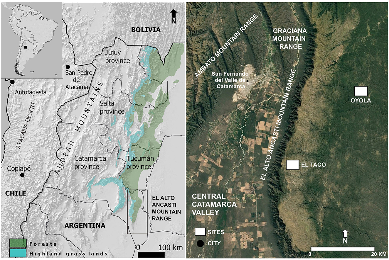
Figure 1. Map showing the location of El Alto-Ancasti mountain range and its environmental characteristics.
Due to its geographical location and its distinction as the easternmost Andean region with stone-built agricultural terraces, scholars such as (Ardissone 1945) considered the El Alto-Ancasti range to be the “limit of the Andean world,” marking the boundary of “Andean culture” during the first millennium CE. This notion of the range as both a geographical and cultural frontier has persisted over time. (González 1980), one of the founding figures of northwestern Argentine archaeology, reinforced this idea of frontier and conflict by identifying the eastern limit of the La Aguada culture within the El Alto-Ancasti mountain range (González, 1998). For (González 1980), the mountain range represented a zone of transition and confrontation between the “more developed” Andean populations and the cultures of the Chaco region. La Aguada culture, which (González 1980) argued reached its easternmost extent in this range, was defined as a regional polity characterized by a specific form of economic and political territoriality (González, 1998; Pérez Gollán, 1991). This cultural manifestation was identified through distinctive pottery iconography, widespread use of metallurgy, the establishment of ceremonial centers associated with a shamanic cult in the central valleys of Catamarca Province, and the expansion of agricultural technologies aimed at producing surpluses to support this system (Pérez Gollán, 1994; Laguens, 2004; Figueroa, 2010). The economic dimension of this territoriality was linked to the exploitation of distinct altitudinal zones, drawing on Murra's (1972) model of verticality, which emphasized the strategic use of ecological tiers. Politically, it was conceptualized through a center–periphery model, in which power was exerted from settlements or ceremonial centers typically located in the western valley bottoms (González, 1998; Núñez Regueiro and Tartusi, 2002; Pérez Gollán, 1991; Nazar, 2003). Within this framework, interpretations of the El Alto-Ancasti highlands were primarily articulated from the perspective of the Catamarca Valley, situated to the west of the mountain range.
Inspired by the center–periphery model, a three-tiered model of occupation was proposed for the Catamarca Valley and the La Aguada polities that dominated it. According to this model, the valley floor was dedicated to the acquisition of wild resources through hunting and gathering; the ravines and piedmont areas served as agricultural zones with higher population density; and, finally, the highland grasslands—such as those on the summits of the El Alto-Ancasti mountain range—were considered sparsely populated areas, specialized in camelid herding (Kriscautzky, 1995, 1996–97, 1999; Nazar, 2010). Within this framework, it was assumed that the higher-altitude zones may have hosted, at most, a few temporary herding posts, but not permanent settlements or other forms of production, such as agriculture. Moreover, the eastern slopes of the El Alto-Ancasti mountain range—particularly the dense montane forest—were interpreted as a zone of strong symbolic and ritual significance (De la Fuente et al., 1983; De la Fuente, 1990; Llamazares, 1999/2000, 2004; Nazar, 2010; Pérez Gollán and Gordillo, 1994). This interpretation was grounded in the presence of extensive stands of Anadenanthera colubrina var. cebil, a tree species central to ceremonial practices and likely involved in long-distance trade, as well as in the abundance of rock art, which was seen as evidence of interethnic contact and the exchange of information (Pérez Gollán, 1994).
The eastern slope of the El Alto-Ancasti mountain range has traditionally been interpreted as a zone for the procurement of wild and symbolic resources during the first millennium CE, functioning as a complementary area to the La Aguada culture, whose main settlements in this sector of Catamarca Province were located on the western piedmont of the Catamarca Valley (Kriscautzky, 1996–97: 33). Kriscautzky proposed a spatial use model for the Catamarca Valley, suggesting that La Aguada populations developed an environmental exploitation strategy centered on maize agriculture, practiced both in terraced areas of the piedmont and in irrigable zones supplied by the main river—the Río del Valle. This agricultural base was complemented by hunting wild species, gathering forest products from the lowlands, and camelid herding in the highland grasslands. In the eastern sector of the valley, these herding areas corresponded to the highland grasslands of El Alto-Ancasti. Following this logic, (Nazar 2003) associated the domestic architecture found in this microenvironment with temporary herding posts managed by groups originating from the valley floor, and argued for the absence of agricultural activities at these elevations.
The discovery—through our research and that of other scholars (Nazar, 2003; Dlugosz, 2005; Gordillo et al., 2017; Eguía, 2019; Taboada and Rodríguez Curletto, 2022)—of a previously undocumented village landscape in the area, one that challenges traditional archaeological categories and models, necessitated the development of new conceptual and methodological strategies to frame and interpret these emergent landscapes. As a result, a shift in theoretical perspective was proposed—one that prioritizes the understanding of the “production of the local” (Quesada et al., 2012) as key to unraveling the complexity of the societies that inhabited this space during the first millennium CE. To define what we mean by “the local,” we draw on Appadurai's (2001) formulation, in which “the local” is not merely a spatial scale but a relational and contextual quality—what he terms a “complex phenomenological quality”—formed through the dynamic interplay of social immediacy, the technologies of social interaction, and contextual relativity (Quesada et al., 2012; Quesada, 2017). In this sense, the local is not a pre-existing condition but a social product—an inherently fragile achievement that must be continuously constructed, nurtured, and maintained through everyday practices and the materiality of lived experience. This approach represents a shift from an external gaze—one that defines the region in relation to external centers of power—toward an intrinsic understanding of the social, economic, and territorial dynamics that were forged and developed locally.
This theoretical lens encouraged us to explore how the production of the local was materialized archaeologically—what forms it took, and what practices it entailed. To operationalize this concept within archaeological analysis, we adopted the notion of the “neighborhood” (Quesada et al., 2012) as a privileged analytical scale for understanding the processes involved in the production of the local. As Appadurai's (2001) argues, neighborhoods are not solely defined by physical space but also by models of social interaction, modes of communication, and the collective imagination in the construction of community. Accordingly, our objective was to reconstruct landscapes of everyday life at both the domestic and community levels, examining how habitual practices, daily interactions, and the spatial configuration of built environments mediated the formation of neighborhood relations and, ultimately, the production of the local. This approach enabled us to explore the experiential dimension of inhabiting the landscape, recognizing how seemingly routine activities—such as agricultural work, territorial movements, and landscape observation—contributed to the creation of a sense of social immediacy, fostered particular human–environment relationships, and shaped a meaningful local world for its inhabitants over several centuries. Furthermore, these concepts are aligned with a bottom-up perspective on social complexity (Erickson, 2006; Quesada, 2006), moving away from neo-evolutionary, top-down models that define complexity primarily in terms of the presence or absence of centralized forms of social organization—a framework often applied to both the Formative period and later phases in northwestern Argentina (Leoni and Acuto, 2008).
Building on these theoretical developments, and drawing upon surveys, excavations, and analytical studies conducted in recent years, this paper offers a renewed interpretation of the historical trajectory of the El Alto-Ancasti mountain range from a local perspective. Rather than adopting a broad, top-down social narrative, we focus on the specific ways in which human communities engaged with their surrounding environments through daily practices. To characterize how this village-based agropastoral lifestyle developed in both the highland grassland and forested zones of the mountain range, we examine the articulation, production, and reproduction of three key elements over time: productive spaces (agricultural terraces), domestic spaces (households), and ritual spaces associated with rock art. The multi-analytical data presented in this paper has been previously discussed in various studies (Gastaldi et al., 2016, 2023; Gheco, 2017; Moreno et al., 2022; Quesada et al., 2012, 2016; Quesada and Gheco, 2011; Zuccarelli Freire, 2020; Zuccarelli Freire et al., 2022). However, in this work, we introduce new findings and integrate the data within a novel interpretive framework aimed at reconstructing local neighborhoods and examining how locality was materially shaped and socially enacted across the El Alto-Ancasti mountain range. This approach enables a critical reassessment of traditional political and economic interpretations of the region—and, more broadly, of the eastern Andean slopes—and underscores the importance of constructing archaeological insights firmly grounded in local evidence.
3 Village landscapes, agrarian territorialities, and the production of the local in El Alto-Ancasti mountain range
Research conducted in the El Alto-Ancasti mountain range over the past 15 years has focused on two distinct microenvironments: the highland grasslands and the montane forest, with fieldwork concentrated in the localities of El Taco and Oyola, respectively. In both regions, a range of methodological activities has been undertaken, primarily involving systematic surveys and the documentation of archaeological evidence—particularly architectural features associated with domestic compounds and agricultural terraces. In addition, stratigraphic excavations were carried out at several archaeological sites related to domestic activities and rock art contexts, including rock shelters and eaves. Research has also extended into the intermediate zones between these microenvironments, particularly at Puesto La Mesada, where studies have focused on rock art and the documentation of associated archaeological structures (Gheco et al., 2020).
In the case of El Taco, several domestic compounds were identified in elevated sectors, situated on loessic plains and associated with agricultural terraces located in adjacent ravines. One of these domestic units (El Taco 19) was excavated, providing valuable insights into patterns of habitation and allowing for the calibration of its chronology to the second half of the first millennium CE (Gastaldi et al., 2023; Quesada et al., 2012). Furthermore, analysis of the recovered material culture enabled the characterization of the social practices carried out within these domestic spaces (Ahumada and Moreno, 2015–2016; Barot and Gasparotti, 2018; Egea and Moreno, 2021; Gastaldi et al., 2023; Moreno, 2014; Moreno and Quesada, 2012; Moreno et al., 2022). In addition, the agricultural terraces were systematically surveyed, documented, and sampled to investigate the historical processes underlying their construction and to identify the cultivated species associated with them (Quesada et al., 2012; Zuccarelli Freire, 2014, 2020; Zuccarelli Freire et al., 2022).
In contrast, research in the montane forest began around a rock art site that had been known for several decades. Building upon investigations carried out at this location, a total of 37 eaves and rock shelters containing rock art were identified and documented. Numerous archaeometric studies were conducted with the aim of reconstructing the histories of the paintings, analyzing the chemical composition of the pigments, and identifying the techniques of application (Ahets Etcheberry and Gheco, 2022; Ahets Etcheberry et al., 2024; Landino et al., 2023; Gastaldi et al., 2016; Gheco, 2017, 2020; Gheco et al., 2019, 2020; Quesada and Gheco, 2011; Quesada et al., 2016). Additionally, one of these rock shelter—Oyola 7—was excavated, yielding information that enabled the interpretation of an occupation pattern marked by alternating periods of greater and lesser activity, without evidence of permanent residential use (Gastaldi et al., 2016; Gheco, 2017, 2020; Gheco et al., 2019).
However, the broader cultural landscape shifts when one moves beyond the hill where these rock shelters are concentrated. In the surrounding area, a cultural landscape has been identified that closely resembles that of the highland grasslands, characterized by the integration of domestic compounds, agricultural terraces, and a distinct form of rock art (Gastaldi et al., 2016, 2023; Quesada et al., 2016; Zuccarelli Freire, 2020; Zuccarelli Freire et al., 2022). Two of these domestic spaces—Oyola 50 and Oyola 51—have been excavated, revealing occupation dynamics and a chronology comparable to those identified at El Taco 19 (Clauss and Egea, 2024; Gastaldi et al., 2023; Quesada et al., 2016; Quiroga Viñas and Gastaldi, 2022).
In what follows, we describe the main characteristics of these village landscapes and the processes through which they were constituted and shaped in the eastern Andean slopes.
3.1 Agricultural landscapes: las chacras
Evidence of extensive terraced landscapes in Neotropical mountainous forests has not been systematically assessed in northwestern Argentina. In particular, such practices have largely been abandoned—or are only sporadically utilized—in the semi-arid mid-altitude valleys and the montane forests of the eastern slopes (Nagel, 2022; Nagel et al., 2023; Zuccarelli Freire et al., 2022). The presence of terraces in these areas has frequently led to mountain agriculture being interpreted within the broader framework of “the Andes.” However, it is important to note that the dominant models for understanding terracing have been primarily shaped by research conducted in highland or puna regions—especially within the Argentine Andes—where traditional practices persist in the arid highlands (Korstanje, 2005; Korstanje and Quesada, 2010; Quesada and Gheco, 2011). In our study region, located on the eastern slopes, there is a significant disconnect between historical Indigenous land use practices and those of contemporary populations, which have largely focused on livestock rearing and monocrop cultivation in deforested lowland areas since the Spanish invasion. Terraced landscapes beyond these zones have long been overlooked, with few historical references (e.g., Ardissone, 1945) prior to the initiation of our systematic surveys over the past decade.
Our studies have contributed to the reconstruction of thriving agrarian landscapes across the semi-arid and forested areas of the El Alto-Ancasti region, where agroforestry management was integrated with llama herding—practices no longer present in the eastern Neotropical forests of northwestern Argentina (for further details on camelid herding in this region, see Moreno et al., 2025 [this research topic] and Moreno et al., 2022). The research was carried out in various localities across the mountain range, selected specifically for their contrasting ecotonal characteristics along the altitudinal gradient. Thus, the study encompassed areas ranging from highland grasslands, situated between 1,600 and 2,000 meters above sea level (e.g., El Taco and Puesto La Mesada), to montane forests located between 800 and 1,500 meters (e.g., Oyola and La Candelaria). More than 1,000 terraces were identified across the El Alto-Ancasti mountain range, extending throughout both forested and highland grassland areas, thereby revealing a regional pattern that spans multiple environments. In each microenvironment, similar anthropogenic landscapes were developed, creating heterogeneous productive zones that were not segmented into distinct altitudinal or biome-based bands. By emphasizing the gradual nature of ecological transitions, the adaptability of cultivated plants to varying environmental conditions, and the capacity of terrace and runoff agriculture to buffer climatic fluctuations, pre-Columbian communities shaped landscapes and productive systems that displayed striking continuity across ecologically diverse environments (Figure 2).
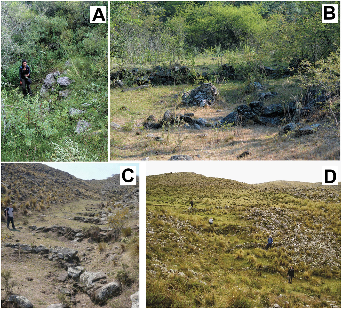
Figure 2. Agricultural terraces examples: (A, B) Oyola, (C) Puesto La Mesada, (D) El Taco.
According to preliminary radiocarbon dates obtained from an agricultural terrace in Oyola, the productive system in the forested area may have begun as early as the first centuries of the Common Era (ca. 100 AD) and appears to have been in full use by approximately 545 AD (Figure 3, Table 1). These represent the first direct dates from terraced agricultural structures in the forested regions of northwestern Argentina. Due to the inherent challenges in establishing reliable stratigraphic sequences in terrace contexts, it is not yet possible to reconstruct a detailed chronology of how this agrarian landscape evolved throughout the first millennium CE. Nevertheless, our research in both highland grasslands and forested areas suggests a prolonged process—lasting at least 300 years—of agrarian landscape construction (Zuccarelli Freire et al., 2022). This indicates a transgenerational practice sustained over centuries, as inferred from the consistent construction techniques observed and the overlapping chronologies of other sites investigated in the region.
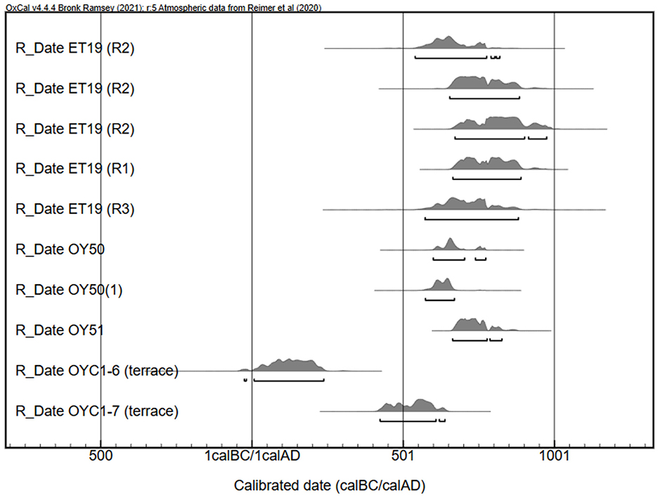
Figure 3. Radiocarbon dates obtained from residential units (El Taco 19, Oyola 50 and Oyola 51) and agricultural terraces (Oyola C1).
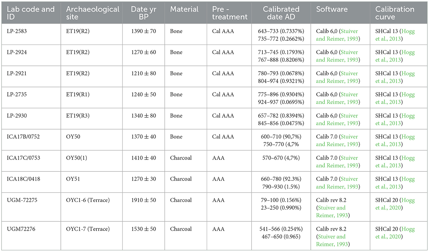
Table 1. Details of the radiocarbon dates presented in Figure 3, following Millard (2014).
In assessing the emergence of these agrarian landscapes, a basic modular unit of the productive system has been proposed (Zuccarelli Freire, 2020). This model suggests that the process began with the establishment of dwellings in naturally fertile areas on the loessic summits, accompanied by attached structures dedicated to domestic production. From these initial settlements, the surrounding ravines were progressively terraced, both to expand the area available for cultivation and to protect the loessic esplanades from erosion (Figure 4). This sequence of development led to a dendriform expansion of the agrarian landscape.
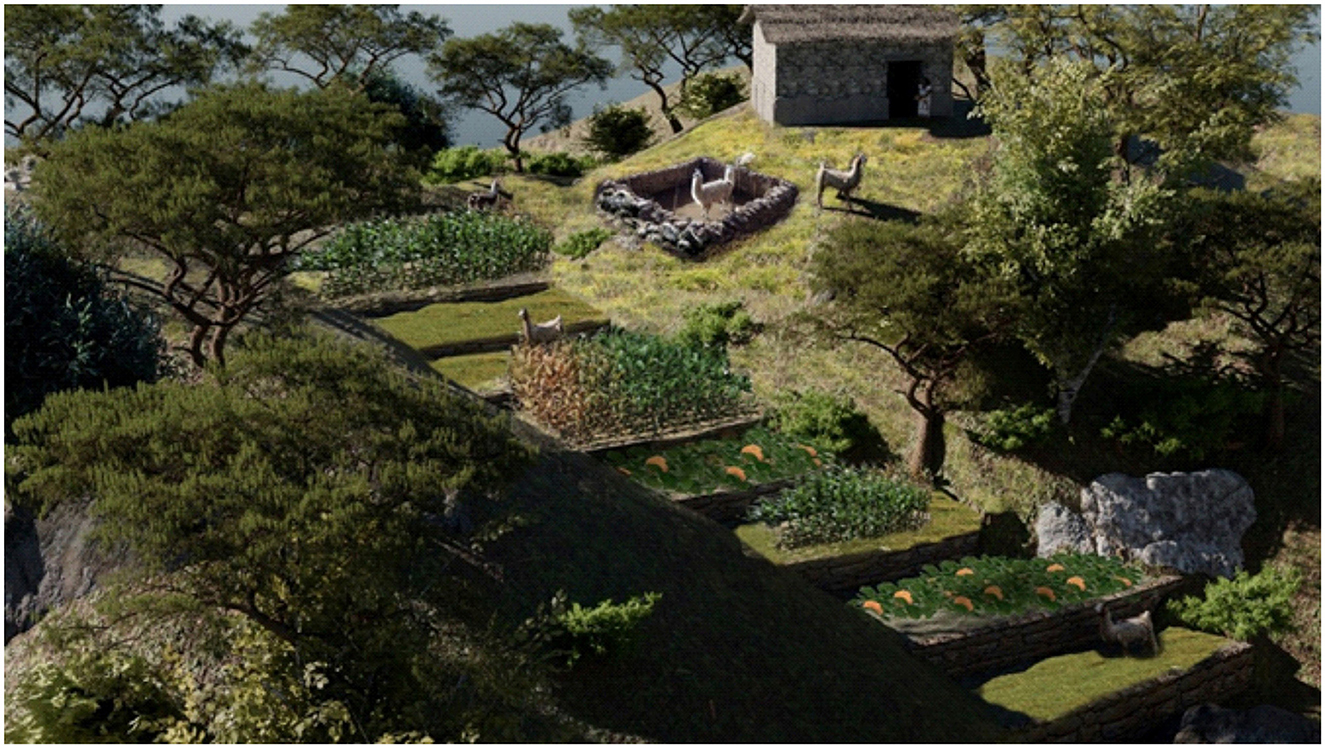
Figure 4. Schematic 3D reconstruction of the model of the village landscape, produced in Blender 4.3 and GIMP 3.0.2., linking domestic compounds in the higher sectors with agricultural terraces in the adjacent ravines.
The dominant terracing construction technique in the El Alto-Ancasti mountain range was the cross-channel modality (sensu Treacy, 1994). This method involved the construction of transverse walls spanning entire ravines, with their heights carefully adapted to the natural slope of the land. The lower sections of these walls were filled with gravel and small stones to promote water filtration while allowing sediment to accumulate behind them. This process facilitated the formation of organic-rich soils suitable for agriculture and suggests a long-term strategy aimed at preserving and enhancing soil resources over time. Phytolith analyses revealed a diversity of cultivated crops on these terraces, including maize (Zea mays), cucurbits, legumes (Fabaceae), Cannaceae, and possibly subtropical rhizomes or tubers such as yacón or cassava. These crops were identified in both the highland grassland and montane forest sectors of the mountain range (Zuccarelli Freire et al., 2022). The presence of Zea mays, Phaseolus sp., and cucurbit remains in both ecological zones underscores their importance across varied environmental contexts (Figure 5).
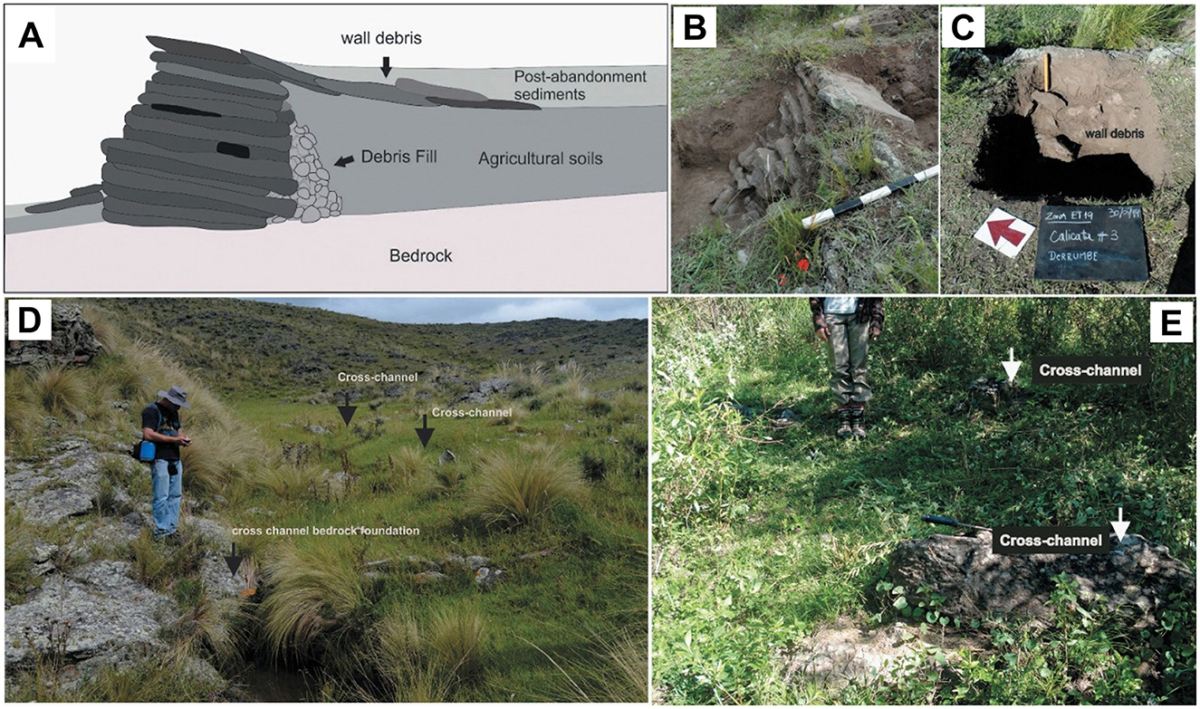
Figure 5. Construction features of agricultural terraces. (A) Construction model of these structures; (B) Retaining wall; (C) Wall debris; (D) Example of the type of agricultural terraces identified in the highland grasslands and their connection to the bedrock; (E) Example of the type of agricultural terraces identified in the montane forest (taken from Zuccarelli Freire et al., 2022).
Beyond terraces, the agroecosystems of the El Alto-Ancasti mountain range also involved the strategic use of fire. Fire technology is a widespread and long-standing tool for creating and maintaining productive habitats in tropical and subtropical regions (Arroyo-Kalin, 2016; Iriarte et al., 2020; Yost, 2008). Its use has been consistently identified in studies of first-millennium societies in Catamarca (Gordillo, 2007; Lindskoug and Marconetto, 2014). In the context of El Alto-Ancasti, fire may have also served as a preventative measure against uncontrolled wildfires by reducing flammable biomass, as has been observed in Australian Indigenous land management practices (Pyne and Goldammer, 1997; Roberts et al., 2021). In the analyzed crop fields, the presence of carbonaceous material derived from domestic waste and controlled burns was notable in both grassland and forest contexts. In the forested terraces specifically, evidence of controlled burning was indicated by the presence of thermoaltered phytoliths, including burnt arboreal and grass taxa, melted phytoliths, and varying concentrations of microcharcoal particles in the sediments (Zuccarelli Freire et al., 2022). Soil enrichment practices may have also included selective pruning of natural vegetation and the continual deposition of organic matter from trees, shrubs, weeds, and crop residues (Figures 6, 7). Additionally, as seen in contemporary terraced landscapes, these flat surfaces often double as grazing areas, suggesting that South American camelids may have been herded in similar contexts in pre-Columbian times as part of an integrated agro-pastoral system.
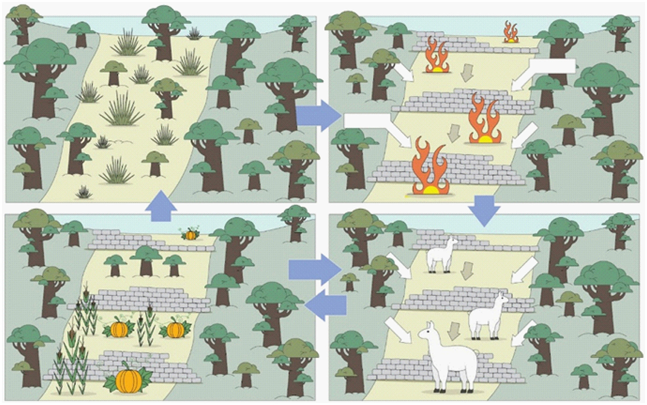
Figure 6. Hypothetical diagram of the productive cycles of the agroforestry system of the first millennium in the Sierra based on terrace analyses (for further details see Zuccarelli Freire et al., 2022). During stage one, there was evidence of forest or shrubland burning and maize cultivation.
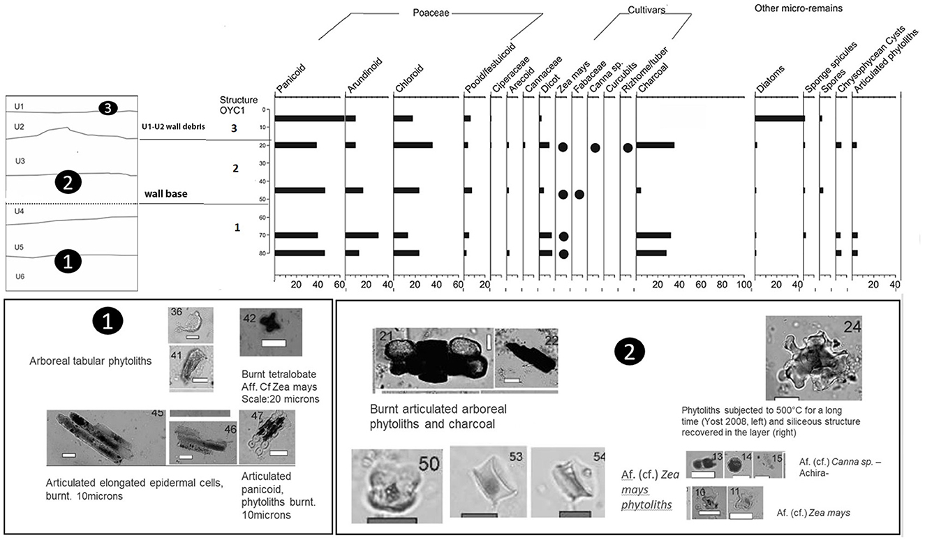
Figure 7. Phytolith assemblages recovered from one of the surveyed terraces in the forest area showing alternating fire intensities, presence of burnt phytoliths from grass and arboreal species, melted phytoliths indicating controlled fires and cultigens.
Finally, a key aspect of the agricultural landscape constructed in the El Alto-Ancasti mountain range is its plasticity in response to seasonal fluctuations and, potentially, to longer-term climatic challenges such as ENSO (El Niño–Southern Oscillation) events. The use of satellite imagery has enabled a broad assessment of microclimatic variability within and between study areas, allowing for the visualization of differential moisture distribution patterns. In loessic esplanade systems and along stream corridors, the availability of capillary water fluctuates across seasonal and multi-annual climatic cycles (Zuccarelli Freire et al., 2022). Even during wet seasons, distinct sectors of the agricultural landscape exhibit variable responses to water input. Our moisture analysis using satellite data suggests that during wetter periods, moisture distribution and vegetation development become more spatially homogeneous. In contrast, during dry seasons, moisture tends to concentrate in the lower ravine areas and other specific landscape sectors. This pattern indicates that, during droughts, certain areas within the agrarian landscape may have played a critical role in mitigating risk, enabling adaptive production strategies. A key technical feature—previously undocumented in such detail for the Argentine Northwest—is the check dam system identified at El Taco 19 (Zuccarelli Freire et al., 2021). This system demonstrates that the agricultural infrastructure was subject to gully erosion, which led to soil degradation. The presence of containment dams within these gullies indicates that erosion was already an active process during the pre-Hispanic occupation (ca. 600–1000 CE), at a time when the agricultural system was still in use.
To deepen our understanding of the relationships between humans and climate, we incorporate the study of paleoclimatic models based on paleo-NDVI data, supported by different proxy indicators, in order to better reconstruct past environmental conditions (Melendez et al., 2024). Using the Hindcasting Ecosystems Model (HEMO), paleo-NDVI was reconstructed through artificial neural networks trained with modern NDVI data derived from AVHRR/NOAA satellites (1982–2015), along with dendrochronological series from northwestern Argentina. This integration allows regional paleoclimatic information to be translated into local scales of analysis, producing reconstructions of vegetation dynamics specific to the areas where the settlements and agricultural terraces under study are located.
According to this model, five distinct climatic periods were identified between 442 and 1980 CE, each characterized by extreme fluctuations between arid and humid phases (Figure 8). For example, the earliest period, extending from the beginning of the sequence to approximately 550 CE, displayed high NDVI indices, indicating favorable environmental conditions and increased moisture availability. The basal charcoal material from the sampled terrace in Oyola dates to this period. However, despite this evidence of environmental suitability, almost no clear archaeological indicators of human occupation prior to 550 CE have been identified. It has been proposed that initial village landscapes may have begun to take shape during this phase, though further research is necessary to substantiate this hypothesis.
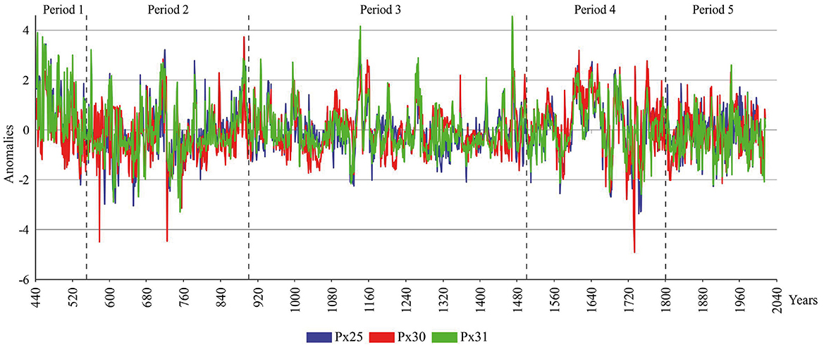
Figure 8. NDVI graph taken from Melendez et al. (2024).
Between 600 and 700 CE, the models indicate environmental conditions comparable to those of the present day. However, from 700 to 1,000 CE, NDVI values decline significantly, indicating a prolonged dry phase with less favorable environmental conditions. Paradoxically, it was during this period that communities established widespread agrarian landscapes in the region. These groups practiced runoff agriculture adapted to environmental variability, as evidenced at sites such as El Taco 19 in the highland grasslands and Oyola 50 and 51 in the forested zones. After 1,000 CE, the archaeological record becomes more fragmented, making the nature and continuity of occupation less certain (see Figure 3). From the 15th century onward, the paleo-NDVI models display increasingly pronounced fluctuations, with extreme positive and negative anomalies reflecting heightened climatic variability that persists to the present day. Collectively, these findings suggest a compelling pattern: the agricultural landscape of the El Alto-Ancasti mountain range reached its greatest extent not during favorable climatic conditions, but rather under drier and more arid conditions than those currently observed. This underscores the exceptional adaptability of local agricultural strategies in managing environmental stress. It is important to emphasize that the construction of the agricultural landscape was accompanied by the implementation of various techniques, such as water management, erosion control, and agroforestry practices, which illustrate how these communities developed specific strategies to cope with drier and more arid conditions (Zuccarelli Freire et al., 2022). The paleoenvironmental modeling—offering higher temporal resolution than many traditional proxies—enables the reconstruction of possible scenarios that framed the development of agrarian landscapes across the mountain valleys and their diverse ecotones. For instance, while vegetation development in certain areas is strongly correlated with vertical rainfall (as in grasslands and piedmont forests), in the grasslands of the El Alto-Ancasti range, moisture from montane forest mists likely played a critical supplementary role, complementing vertical precipitation inputs.
3.2 Domestic compounds: houses
Another key component of the village landscape is the presence of domestic units located in elevated sectors of the terrain, both in the highland grasslands and forest environments. These residential areas appear to function as central nodes in the articulation of agricultural landscapes. Across various zones of the El Alto-Ancasti mountain range, numerous residential compounds have been identified on the upper slopes of hills, from which terraced ravines extend downward (Quesada et al., 2012, 2016; Zuccarelli Freire, 2020; Gordillo et al., 2017). These compounds exhibit variation in size and internal organization. While most display quadrangular floor plans, they differ in the number and dimensions of rooms, open spaces, patios, and associated architectural features. Larger compounds—such as El Taco 19 (ET19), located in a summit area (Figure 9A)—may include more than 28 enclosures. These often feature a core sector with higher architectural density, consisting of large enclosures (sometimes exceeding 30 meters per side) that may have served as patios or communal spaces. These are typically surrounded by smaller enclosures (up to 4 meters per side), likely used for habitation. In addition, larger compounds often incorporate spatially distant but clearly integrated elements, such as extensive enclosures and parallel low walls forming agricultural terraces. In contrast, smaller household units exhibit simpler configurations. These may consist of a single large structure; two small, non-adjoining enclosures; an isolated small room; a large enclosure with a small annexed structure; or two large, non-adjoining enclosures, as seen at Oyola 50 in the forested zone (Figure 9B). Collectively, these patterns point to a structured spatial logic in which domestic architecture served not only residential purposes but also played a pivotal role in organizing productive activities and potentially mediating social relations across the landscape.
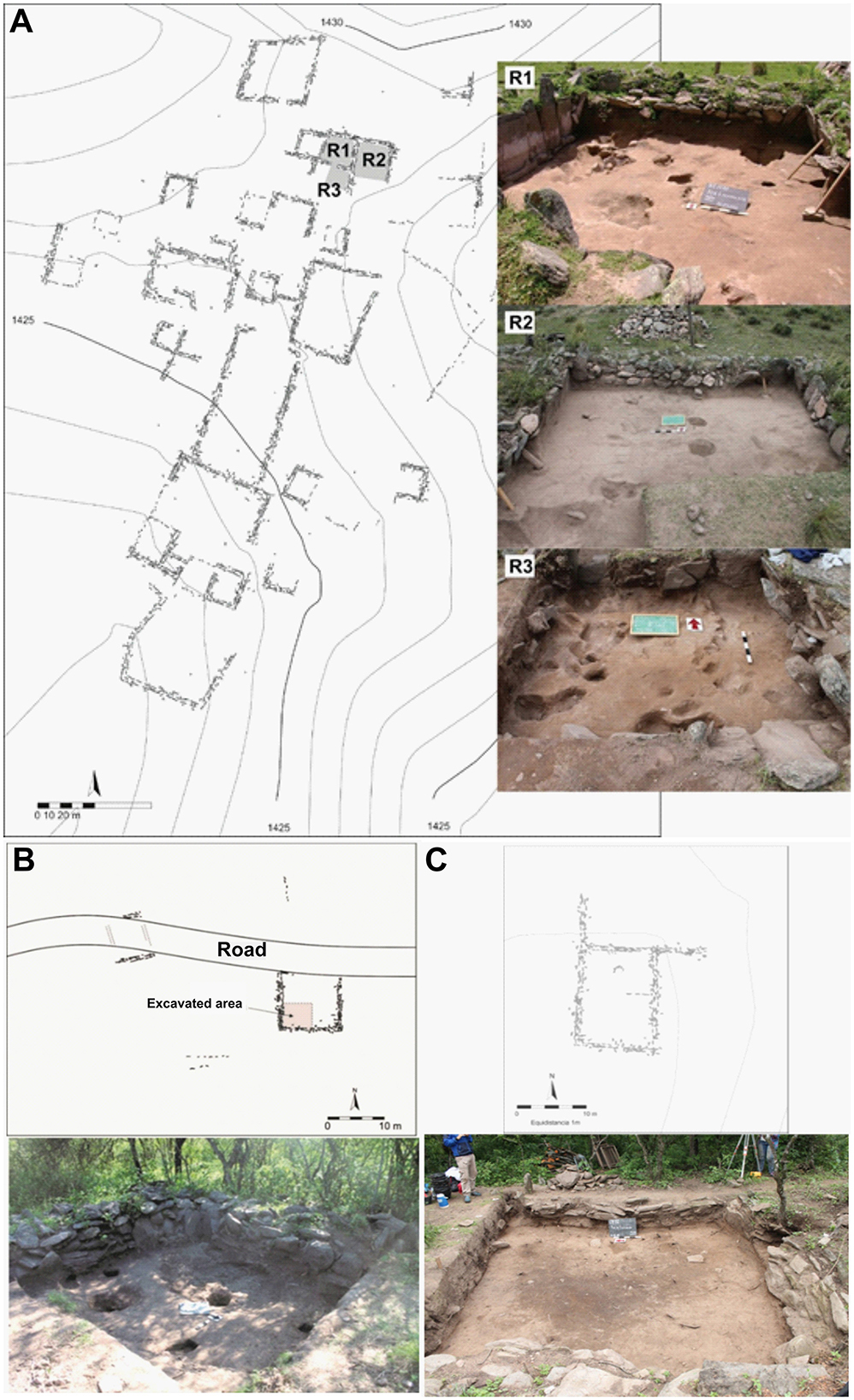
Figure 9. Characteristics of domestic compounds: (A) El Taco 19, (B) Oyola 50, (C) Oyola 51.
To better understand how residential sites developed over time, we conducted stratigraphic excavations at three domestic compounds located in distinct microenvironments—one in the highland grasslands (El Taco 19) and two in the montane forest (Oyola 50 and Oyola 51) (Figure 9). These excavations aimed to characterize the biographical trajectories of the houses (Gastaldi et al., 2023; Quiroga Viñas and Gastaldi, 2022), considering their histories of construction, modification, abandonment, and reoccupation. A recurring pattern observed across all three sites was the presence of multiple cycles or phases of occupation. At El Taco 19 (ET19), situated in the highland grasslands, 300 stratigraphic units were recorded and grouped into 10 occupational phases. The construction of the stone enclosures uncovered during excavation corresponds to only one of these phases. Prior to their construction, the site experienced five distinct occupation cycles characterized by alternating uses of the space—for example, as a refuse area, followed by reconfigurations to accommodate domestic activities such as food preparation, lithic knapping, and tool maintenance. After this period, the site adopted its current architectural configuration, with domestic activities taking place either in open-air contexts or within roofed areas lacking formal structural boundaries. In general, the occupational histories of these domestic spaces conclude with structural abandonment and subsequent reuse of the area as a refuse zone (Figure 10). Similar trajectories were observed at the two sites excavated in the forested zone (Quesada et al., 2016). At Oyola 50 (OY50), nine stratigraphic phases were identified, with the extant stone enclosure corresponding to the sixth phase. Earlier uses of the area included functions such as an open-air kitchen, refuse dump, and temporary shelter. Like other sites, its occupational sequence ends with abandonment and reuse as a dumping area.
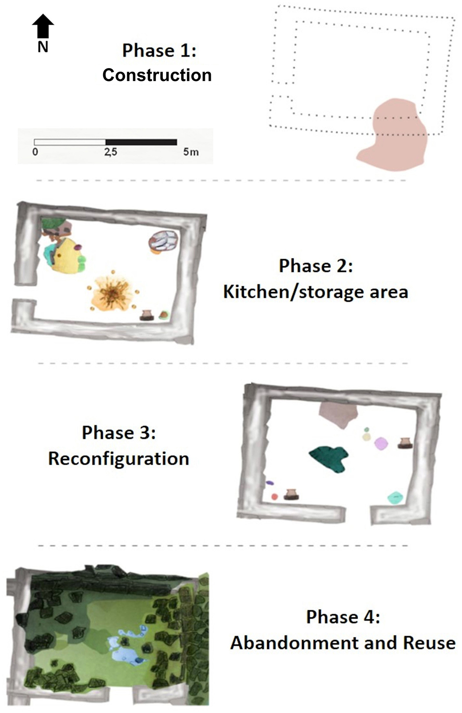
Figure 10. Occupation sequence of one of the ET19 enclosures (R1): Phase 1 – Construction: The surface of a pre-existing refuse pit was leveled, the floor was smoothed, and the walls of the room were erected. Phase 2 – Domestic use: The space was converted into a kitchen/storage area. Pits lined with stone slabs were built, a combustion structure was installed, and various vessels and items related to food preparation and consumption were identified. Phase 3 – Reconfiguration: The entrance to the enclosure was modified, now oriented to the south. The former floor was leveled, which involved removing the combustion structure and sealing the slab-lined pits. Phase 4 – Abandonment and reuse: The enclosure was abandoned, and its walls began to collapse. During this period, the space was repurposed as a workshop for the production of lithic artifacts.
Chronologically, radiocarbon dates place these residential occupations within a contemporaneous range between AD 600 and 800 (Gastaldi et al., 2023; Quesada et al., 2012, 2016), supporting the hypothesis of neighborhood formation across different sectors (see Figure 3 and Table 1). Despite differences among the three excavated sites, several key aspects emerge that characterize their use. First, the radiocarbon dates indicate synchronic occupations during the second half of the first millennium CE. Second, the sequence of events includes pre-wall occupation, the construction and transformation of architectural features, soil preparation for various activities, and eventual abandonment—occurring in relatively synchronized fashion by the early second millennium CE. Additional parallels are evident in the material culture from El Taco and Oyola, particularly in technologies, such as lithic tools and pottery, and in patterns of animal consumption. In terms of lithic technology, quartz was used almost exclusively as the raw material for stone tool production, representing approximately 96% of the analyzed assemblages. The complete production sequence is present, including the manufacture of retouched tools with generalized edges, reflecting a domestic-scale strategy of social reproduction (Egea et al., 2024; Egea and Moreno, 2021; Moreno, 2014). This reliance on quartz demonstrates a deliberate use of locally available raw materials, irrespective of their mechanical properties, suggesting procurement from areas surrounding the residential compounds. Ceramics recovered from domestic contexts include vessels decorated in styles identified as “Aguada de Ambato” and “Aguada Portezuelo,” which were shared among groups inhabiting the wider region. However, detailed analysis of the pottery reveals significant variability in manufacturing techniques, indicating distinct local adaptations. This suggests that artisans were not merely replicating Aguada stylistic norms but were instead incorporating these forms into their own cultural and functional frameworks. The result is a distinctive regional expression of the broader Aguada aesthetic (Gheco et al., 2024).
To characterize the household practices, we conducted complementary studies of grinding artifacts and ceramic fragments found at the Oyola 31 site (Figure 11), the only set of structures located a short distance from the eaves with rock art, dated to 1,150 ± 30 BP (ICA16B/0104, bone). This site is interpreted as a temporary or sporadic habitation area, as its architecture reflects an expedient type of construction, primarily built using a high proportion of perishable materials (Quesada et al., 2016; Boscatto and Ferreyra, 2024). By integrating morphotechnological data with the analysis of microresidues attached to these artifacts, we were able to reconstruct certain plant-use trajectories that, in some cases, converge across these two materialities. Specifically, plant microresidues indicate the possible presence of cereals (Zea mays), fruits (Neltuma sp., species of the Fabaceae family), rhizomes (Canna edulis), and wild fibers (Arecaceae), all of which were identified in both the grinding artifacts and the vessel (Figure 11) (Boscatto and Ferreyra, 2024). This microresidue analysis contributes to our understanding of the processing and consumption of crops and other plant resources, offering a comprehensive perspective on environmental management and highlighting the significance of certain species in daily diets and potential ceremonial contexts. Moreover, a pipe recovered from ET 19 yielded microremains indicative of the consumption of Anadenanthera colubrina var. cebil seeds and native tobacco (Lema et al., 2015). This finding provides direct evidence of the use and circulation of psychoactive and ritual plants originating in forested areas located several kilometers away, highlighting the breadth of plant assemblages and consumption practices. Once again, the presence of microresidues from both cultivated plants and wild forest fruit suggests an extensive and integrated use of the landscape, alternating periods of crop harvesting with the foraging of naturally available resources. This evidence also links domestic structures to broader anthropogenic landscapes under construction across the region.
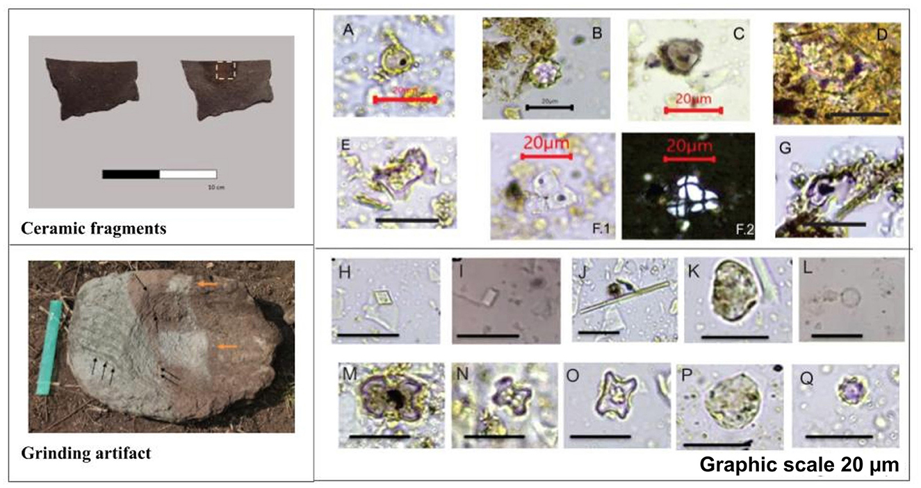
Figure 11. Top left: ceramic fragments with the sampling area indicated in yellow. Bottom left: grinding artifact; orange arrows indicate sampling areas; black arrows indicate striations in the rock, linked to the artifact's use. Right: phytoliths and starch grains present in the samples from the ceramic vessel (A–G) and the conana (H–Q): (A) Globular with perforation, aff. Cactaceae cf. Opuntia sp. according to (Korstanje and Babot 2007). (B) Echinate globular, aff. Arecaceae. (C) Circular phytolith of pooid affinity, sooty or heat-altered. (D) Faceted, hollow phytolith related to Fabaceae. (E, G) Cruciform phytoliths, cf. Zea mays. (F) Articulated starch, related to Zea mays: 1. Bright field, 2. Polarized light. (H) Rhomboid calciphytolith cf. Anadenanthera colubrina according to (Lema et al. 2015) and (Martín Silva et al. 2016). (I) Polyhedral calciphytolite. (J) Rafidio. (K, P) Faceted and granulated globular phytoliths similar to Cucurbitaceae. (L) Smooth globular phytolith aff. Bixa orellana according to (Korstanje and Babot 2007). (M–O) Cruciform phytoliths cf. Zea mays. (Q) Globular echinate phytolith related to Arecaceae. Graphic scale 20 μm.
3.3 Ritual activities: engraved rock art
The rock art of the El Alto-Ancasti mountain range has long been among the most intensively studied forms of material culture in the region (De la Fuente, 1979; Gramajo and Martínez Moreno, 1978; Llamazares, 1999/2000; Segura, 1971). For several decades, it was interpreted as a homogeneous and uniform phenomenon, primarily characterized by complex zoomorphic and anthropomorphic figures painted on the interior walls of various shelters, most of which are located within the forested areas. Representations of presumed sacrifices, shamans, jaguars, and snakes were frequently interpreted as central elements of shamanistic practices associated with the La Aguada culture during the second half of the first millennium CE (González, 1998; Gordillo et al., 2000; Nazar et al., 2012, 2014).
In recent years, however, expanded surveys and the documentation of new sites have revealed a more heterogeneous picture of rock art across the range. To date, over 1,100 painted eaves, rock shelters, and boulders have been recorded, grouped into 27 distinct archaeological sites distributed across the region's varied ecological zones (Figure 12) (Gheco, 2017). These findings have coincided with a theoretical reorientation aimed at understanding the specific local histories embedded in some of these sites (Ahets Etcheberry and Gheco, 2022; Gheco, 2020). This shift has enabled a deeper appreciation of the temporal, pragmatic, and contextual diversity of rock art traditions within the mountain range. Consequently, it is now clear that there is no single, unified rock art tradition in the El Alto-Ancasti mountain range. Rather, what emerges is a continuum of distinct local histories, some of which exhibit points of convergence.
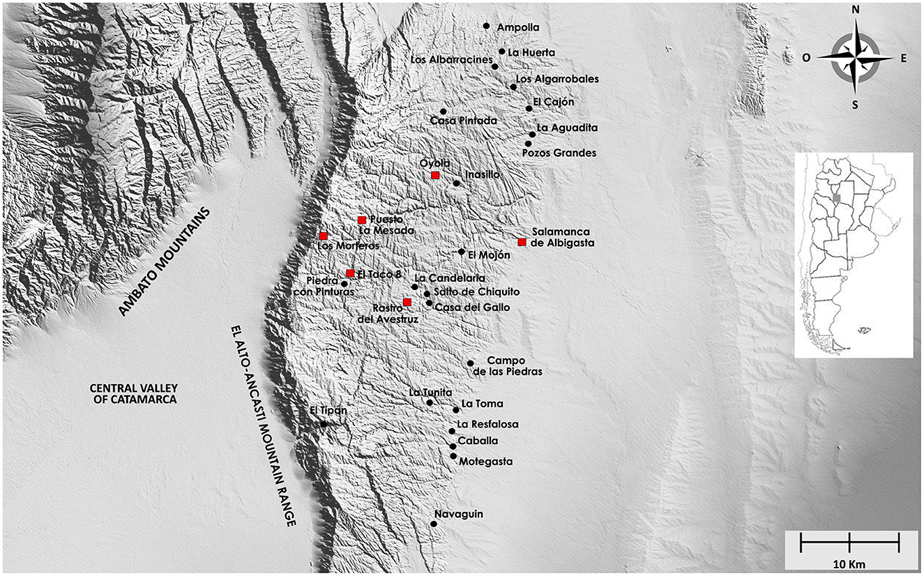
Figure 12. Rock art sites documented in El Alto-Ancasti mountain range. Highlighted in red, cases of engraved rock art archaeological sites.
Multiple lines of evidence—including studies on motif production techniques, materials used, and the spatial organization of the sites—reveal significant differences among the various rock art locations (Ahets Etcheberry et al., 2024; Landino et al., 2023; Quesada and Gheco, 2011). These differences, we argue, reflect diverse relationships between the motifs, the spatial settings in which they were created, and the social practices enacted around them. Most documented sites consist of rock paintings located within shelters situated in dense forest areas along the middle and lower slopes of the mountain range. Sites such as Oyola, La Tunita, and Campo de las Piedras are positioned at considerable distances from residential and agricultural areas (Figures 13A, B). This spatial separation, combined with stratigraphic excavation results from some of these painted shelters, suggests that these spaces were associated with special, short-term, and recurrent social practices (Gastaldi et al., 2016; Gheco et al., 2019). Other rock painting sites, such as Cueva de La Candelaria and Casa Pintada de Guayamba, do not exhibit such marked spatial detachment from domestic and productive areas. Nonetheless, the evidence recovered from excavations does not currently support their interpretation as everyday-use spaces. As with other painted shelters, the available data indicate episodic, short-term occupations. These practices likely involved inter- and intra-group gatherings and rituals related to social reproduction (Moreno et al., 2024; Quesada et al., 2016). While much remains to be understood, these activities contrast markedly with those associated with engraved rock art.
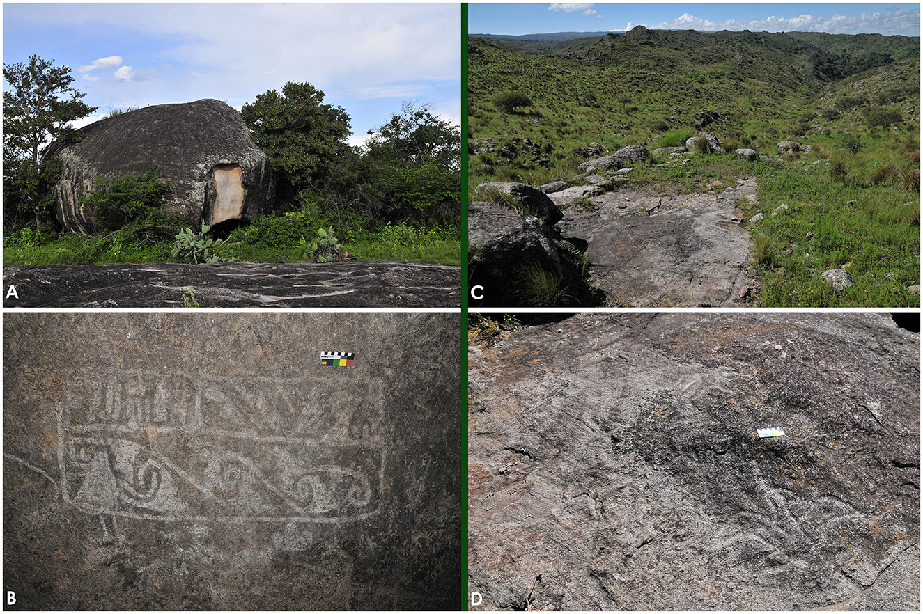
Figure 13. Comparison between painted and engraved rock art from El Alto-Ancasti. (A) External view of one of the shelters at Oyola. (B) Rock paintings of Oyola 7. (C) General view of one of the engraved rocks at Puesto La Mesada. (D) Engraved motifs from Puesto La Mesada.
In contrast to the painted motifs, some engraved rocks have been documented within domestic and productive areas (Gheco et al., 2020). Unlike the painted rock art, which tends to be located in more secluded settings, engravings are found on open-air, flat rock surfaces situated between terraces and dwellings, thereby forming an integral part of the agrarian landscape (Figures 13C, D). Sites such as Puesto La Mesada, located on the high grassland summit of the mountain range, and Oyola, in the montane forest, demonstrate the presence of this form of rock art across both ecological zones (Gheco et al., 2020). The engravings at these sites were produced using a distinctive technique involving deep incision, resulting in grooves up to 1 cm in depth. This method clearly distinguishes them from other engraving techniques such as pecking or superficial abrasion.
At Puesto La Mesada, systematic surveys conducted in recent years have identified seven groups of engraved rocks dispersed throughout the highland grasslands (Figure 14). The motifs are predominantly geometric and linear in nature, with a high frequency of cupules. Figurative designs—such as birds and camelids—are less common. In all instances, the engravings are located on the upper surfaces of horizontal boulders, often in close proximity to mortars carved into the same rocks. Their placement allows for visibility while moving across or near the stones. Each cluster of engraved rocks is embedded within residential and agricultural structures, whose architectural characteristics correspond to those previously described, suggesting a chronology within the second half of the first millennium CE. Comparable associations between engraved boulders, habitation zones, and productive areas have also been documented in nearby highland grasslands, such as at El Taco 8.
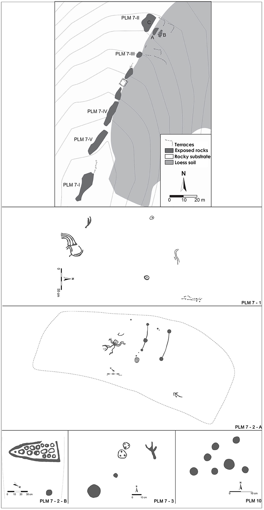
Figure 14. Map and digital tracing of the engraved rock art from Puesto La Mesada.
At Oyola, within the forested zone of the range, deeply engraved motifs have also been documented on boulders situated in contexts similar to those observed at higher elevations. The most frequent designs are cupules, sometimes arranged in aligned sets and associated with mortars carved into the same rock surfaces (Figure 15). Oyola is particularly significant because it provides a unique opportunity to compare two distinct forms of rock art within a single landscape (Quesada et al., 2016). On one hand, the site features painted rock art within 37 small rock shelters located on the upper slopes of a granite batholith. These paintings exhibit a remarkable diversity of figurative designs, predominantly zoomorphic (camelids, jaguars, serpents) and anthropomorphic figures. The motifs are only visible from within the shelters and can be viewed by a limited number of individuals at a time due to the confined interior spaces. On the other hand, the engraved motifs are found on boulders scattered among domestic structures and agricultural fields. These dwellings, previously described, were constructed outside the granite batholith in lower-lying areas near watercourses. Oyola thus presents two contrasting forms of rock art embedded in distinct spatial contexts, potentially reflecting different ritual logics. The engraved art appears integrated into daily life, closely associated with domestic and productive practices, while the painted art is spatially and functionally separated, located in settings likely visited only occasionally for short-term activities such as aggregation events and social reproduction rituals. It is important to note, however, that this clear spatial separation between painted rock art and productive spaces is particularly pronounced at Oyola; in other sites, the relationship appears less distinct and more nuanced.
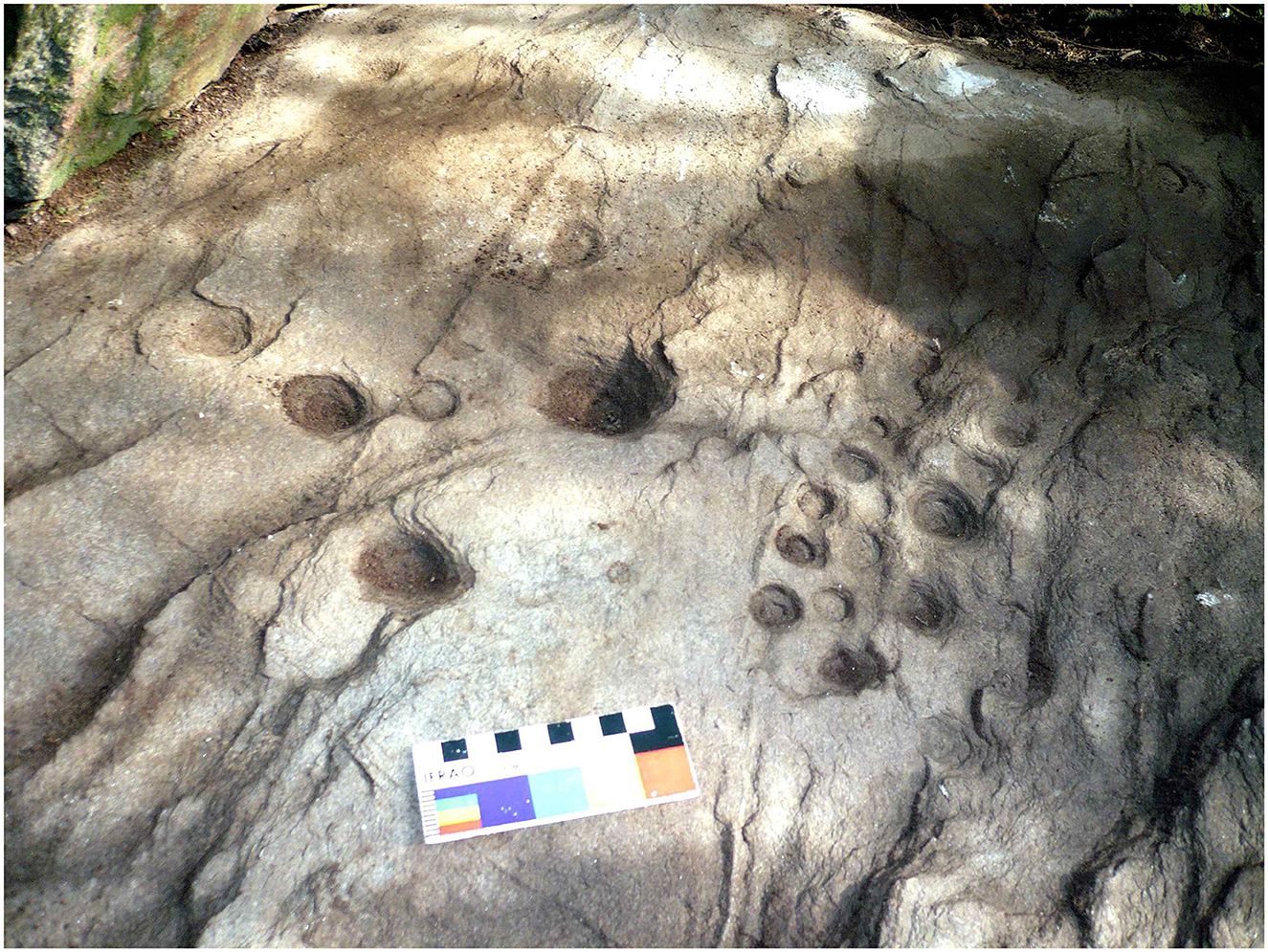
Figure 15. Engraved cupules at Oyola 37.
In summary, across both the highland grasslands—such as Puesto La Mesada and El Taco 8—and the forested zones—including Oyola and other sites such as Salamanca de Albigasta and Rastro del Avestruz—engraved rock art appears to have been created within domestic and productive landscapes. Often located in proximity to mortars, terraces, and residential structures, these engravings constitute an integral component of the everyday environment. People likely encountered these images routinely and may have interacted with them while performing daily tasks such as grinding food or processing materials. Executed on flat, prominently visible surfaces, the engravings seem designed to invite observation and foster social engagement. Embedded within domestic and agricultural contexts, this form of rock art appears to reflect a distinct type of rituality—one rooted in the rhythms and practices of daily life and intimately connected to the cultivation plots.
4 Neighbors and communities at El Alto-Ancasti mountain range
The above elements highlight the construction of domestic landscapes that, while exhibiting varying degrees of settlement aggregation across different areas, consistently adhered to principles of interconnectivity, intervisibility, shared construction techniques, and proximity to both productive and ritual spaces (Quesada et al., 2012). These patterns reflect a communal, agrocentric way of life (Delfino, 2005), in which inter-household spatial configurations formed neighborhood-like structures. The distribution of residential compounds, together with the extensive terraced agricultural areas associated with them, reveals a settlement logic oriented toward the strategic use and long-term management of soils with agricultural potential (Quesada et al., 2012; Zuccarelli Freire, 2014; Gordillo et al., 2017). Furthermore, the spatial arrangement of domestic sites, their adjoining agricultural fields, and engraved rock art suggests the deliberate construction of social interaction spaces tied to the formation of neighborhood relations (sensu Appadurai's, 2001, in Quesada et al., 2012). In the highland grassland sector, there is notable intervisibility among sites: on average, each site maintains visual contact with four others, and in some cases, up to 11 are visible. This pattern points to an intentional design that facilitated intersite interaction. Although intervisibility is reduced in the forested zone due to denser vegetation, the strategic placement of sites on ridge tops likely enabled visibility of smoke plumes from hearths or open-air fires in patios, indicating that visual cues continued to play a role in maintaining social connectivity (Quesada et al., 2012). This settlement pattern is based on the construction of domestic units in higher sectors, in contrast to both historical and recent settlement patterns, where domestic units are located in lower areas, closer to the main watercourses, yet with no intervisibility between domestic compounds1. From this situation, we consider that the choice to establish pre-Hispanic domestic units in elevated sectors was clearly influenced by the significant criterion of intervisibility.
The construction of contexts of co-presence for socialization and community-building is further emphasized by the close relationship between circulation routes and the spatial distribution of residential compounds. Movement across the territory also created opportunities for interaction among the families occupying different household units. In areas such as El Taco, within the highland grassland, primary pathways are located either in low-lying areas adjacent to streambeds or along elevated ridgelines. These elevated routes connect the flattened hilltops where residential compounds are situated and continue to be used by contemporary inhabitants for mutual visits. It is highly likely that these same paths were used in pre-Hispanic times, as they offer efficient transit across the rugged terrain and facilitate the avoidance of natural obstacles such as ravines or waterlogged areas (Quesada et al., 2012).
Considering this dynamic, we propose the existence of a deliberate and recurrent intention to construct elements—houses, fields, paths, and shared spaces—that interacted with one another across relatively short distances. Houses were connected by footpaths; agricultural fields were interspersed among residential areas; engraved rock art and grinding tools were positioned in ways that encouraged gatherings and lingering around them. In both the highland grassland and forested sectors, what emerges is a dispersed yet relational pattern of occupation. As noted by Quesada et al. (2012: 451), this constitutes a distinctive cultural landscape, whose primary organizing elements were domestic units closely associated with terraced agricultural plots and a network of footpaths facilitating mobility through the steep topography. These paths functioned not only as technologies of production and circulation but also as technologies of interaction—means through which social encounters, moments of immediacy, and co-presence were enabled. Through this structuring of the landscape, “the local” materialized as a specific neighborhood form, where visibility and the possibility of visiting one another were practices embedded in the very configuration of the territory (Quesada et al., 2012).
5 Discussion
Throughout this paper—where we synthesize over 15 years of continuous research conducted by the El Alto-Ancasti Interdisciplinary Team, of which the authors are members—we have developed an alternative perspective on the human societies that inhabited the eastern Andean slope during the first millennium CE in this sector of the southern Andes. This approach is grounded in a shift in archaeological narrative, moving away from externally driven ecological or economic models toward frameworks that prioritize local knowledge and the ways in which village landscapes were socially constructed through human practices during the period under consideration. Based on this case study, we propose a broader discussion that extends beyond the history of El Alto-Ancasti with wider implications for the archaeology of the Andean piedmont and for understanding the variability of human–environment relationships across pre-Columbian South America.
Firstly, our data from the El Alto-Ancasti mountain range challenge classical narratives that have long defined these regions as marginal geographic and cultural frontiers in relation to the core cultural developments of the highland valleys or puna areas. One of the main aspects underpinning this notion of marginality is productive specialization, either in camelid herding carried out through outposts maintained by people residing in the valleys, or in the procurement of specialized resources for exchange. This implies a very low and non-permanent population density and, consequently, the absence of both productive and domestic architectural structures. By employing the analytical category of the village landscape to characterize local patterns of settlement and land use, we can explore the interrelations among domestic spaces located in elevated sectors, the construction of agricultural terraces in the ravines, and the associated engraved rock art. This has allowed us to describe—at least partially—the complexity of local land use practices, which diverge from the marginal status traditionally ascribed to them within center-periphery models (Quesada et al., 2012; Zuccarelli Freire, 2014; Gordillo et al., 2017)2. Here, the data obtained from El Alto-Ancasti mountain range challenge classical narratives that have long defined these areas as marginal in relation to the core cultural developments of the high Andean valleys or puna regions. Three key aspects support a critical reconsideration of these traditionally imposed, externally derived interpretations:
1. Contrary to previous archaeological interpretations of the highland grassland zone—which posited the exclusive presence of temporary herding outposts associated with camelid pastoralism managed from the valley of San Fernando del Valle de Catamarca—archaeological evidence now shows the existence of permanent installations. These are accompanied by clear signs of landscape transformation through the construction of domestic and agricultural architecture.
2. A similar type of village landscape has also been documented in the forested areas of the eastern slope, which were until recently conceived primarily as ritual settings centered on rock art eaves and as sources of symbolically valued resources, such as cebil, that circulated within regional exchange networks extending into trans-Andean areas of Chile.
3. The adoption of the analytical category of “village landscape” to describe local patterns of settlement and land use has allowed for a nuanced exploration of the interrelationships among domestic spaces in the highland grasslands, the construction of agricultural terraces in ravines, and the production of engraved rock art. These studies have made it possible to partially reconstruct the complexity of local territorial management practices, clearly contradicting the marginal status traditionally ascribed to the region by core–periphery models (Quesada et al., 2012; Zuccarelli Freire, 2014; Gordillo et al., 2017).
Secondly, our research has allowed us to critically reassess the rigidity of ecological determinism as a framework for understanding the historical trajectories of the populations that inhabited the Andean region. While environmental diversity did indeed foster heterogeneous productive practices across distinct microenvironments, we observe consistent patterns in the ways these territories were occupied—whether in the highland grasslands of El Taco or the forested zones of Oyola. Domestic units share architectural features such as robust walls built with finely cut stones transported to elevated areas, as well as similar spatial configurations and construction sequences involving pre-wall surface preparation, flooring, and shared technological practices. Moreover, the occupation of these sites appears to have been chronologically synchronous. Agricultural spaces likewise exhibit convergent construction strategies: although adapted to local topographies, slopes, elevations, and terrace spacing, all efforts ultimately served to generate arable land from previously rocky or loessic substrates.
Some degree of heterogeneity is observable even within the same ecological zones, underscoring the importance of multidisciplinary approaches and local-scale comparisons to better understand the resilience and legacies of pre-Columbian activities. Variations in the number and size of domestic enclosures, soil management strategies, cultivated plants, and animal husbandry practices (Moreno et al., 2025) point to context-specific decision-making. For example, agricultural terraces differ markedly in their number, layout, and water retention strategies—not according to broad ecological zones, but rather in response to localized topographic, edaphic, and environmental conditions. This suggests the existence of a highly contextualized body of technical knowledge, incompatible with generalized models of Andean hillside agrarian technologies. Overall, the village landscapes examined reveal a coherent pattern in their spatial organization and socio-environmental functioning, implying shared adaptive strategies tailored to the region's ecological diversity. Rather than isolated or marginal expressions, these landscapes represent intentional forms of territorial construction rooted in local knowledge systems, where domestic units, agricultural infrastructure, and mobility networks were interwoven to ensure both productive continuity and social cohesion. This coherence across distinct environmental settings not only highlights the resilience of these agrarian communities but also affirms their active role in shaping and sustaining habitable landscapes over time.
The case of El Alto-Ancasti demonstrates that land use strategies were not rigidly determined by altitudinal ecological zones, as posited in traditional applications of Murra's verticality model (1972) to northwestern Argentine archaeology. Instead, the archaeological evidence reflects the development of overlapping agricultural mosaics (Zimmerer, 1999), implemented across diverse environments through complex, flexible techniques for managing soils, vegetation, and camelid herding. These practices included the use of fire and erosion control in ravines, with long-term geomorphological and ecological impacts still visible today. Such interventions constitute forms of “landesque capital” (Widgren and Håkansson, 2014), in that they not only provided ecosystem services during their use but continue to do so in the present. These pre-Columbian landscapes should thus be recognized as vital components of cultural heritage, particularly in relation to contemporary efforts in sustainable soil and water management (Zuccarelli Freire et al., 2021, 2022; Melendez et al., 2024).
In terms of camelid management, small-scale llama production appears to have been practiced locally, likely involving the use of native vegetation and the spatial separation of animals from cultivated areas—except during post-harvest periods. Zooarchaeological and stable isotope analyses have contributed important insights into the nature of this husbandry system during the second half of the first millennium CE (Moreno et al., 2022, 2025). The Spanish conquest initiated profound transformations in productive activities and land management strategies—changes that ultimately shaped the principal economic systems and landscape configurations still evident today. The conquest and colonization of the region brought significant alterations in land use, including the introduction of European fauna which supplanted native South American camelids; the allocation of extensive landholdings to Spanish settlers; and shifts in settlement patterns, characterized by the relocation of houses to lower elevations near watercourses and the abandonment of agricultural terraces as productive spaces (Castro Olañeta and Carmignani, 2017; Moreno et al., 2019; Nagel, 2022; Nagel et al., 2023).
Thirdly, the construction of neighborhoods in the El Alto-Ancasti mountain range illustrates how the production and reproduction of village landscapes were grounded in the aggregation and establishment of local neighborhood relationships among relatively autonomous domestic units. This aligns with Erickson's concept of a “bottom-up sociopolitical unit” (Erickson, 2006). The strategic positioning of dwellings on elevated topographic locations, which afforded extensive intervisibility among households, reinforced these neighborhood connections. The documented network of footpaths linking these highland settlements provides tangible evidence of routine interactions that facilitated both social and economic exchanges. These dynamics likely arose from productive differences between households and were expressed through social practices such as mutual visits, cooperative labor, and the circulation of goods, all of which contributed to the continuity and meaning of local reproduction. Importantly, this does not preclude the existence of larger-scale collective constructions, political entities, or broader regional processes—such as the ritualized social aggregations connected to the cebil exchange. Evidence from ritual sites featuring rock art—reflected in both the iconography and the presence of widely distributed ceramic styles—suggests periodic regional gatherings at locations such as La Tunita, La Candelaria, and Oyola (Gheco, 2017; Quesada and Gheco, 2011; Quesada et al., 2016). Nevertheless, these broader interactions unfolded within frameworks defined by locally rooted village landscape production, rather than being imposed by external systems.
6 Final remarks
Research adopting a local perspective on village landscapes has allowed us to critically challenge traditional assumptions that have long characterized populations of the eastern Andean piedmont during the first millennium CE. This region—situated between the high Andes and the Chaco-Santiagueño lowlands or forested zones—has frequently been defined as a “liminal” or “frontier” space. Such characterizations are rooted in externally imposed analytical categories that inadequately account for the specific dynamics of land use and social organization developed by pre-Hispanic local populations. Notably, this critique targets the uncritical application of natural altitudinal zonation models for environmental classification, alongside the widespread assumption that historical trajectories in northwestern Argentina are structured by center–periphery spatial dynamics. The concept of a “center” inherently requires defining its “periphery,” often equated with environmentally marginal zones delineated by altitude. Within this framework, highland grasslands and montane forests tend to be viewed as politically and economically subordinate to core agricultural areas, thereby reinforcing narratives that conflate ecological marginality with sociopolitical marginality. This does not necessarily imply the absence of relationships between centers and peripheries, or between areas with greater political centrality and their connections to the margins. Rather, what we suggest is that such relationships should not predetermine interpretations of local populations. Instead, from a locally situated perspective, it is preferable to pursue the reverse path: to conceptualize regional integrations on the basis of contextual data, rather than starting from pre-existing ecological and economic assumptions.
Throughout this article, we have argued that a more fruitful approach to understanding the historical development of pre-Hispanic societies involves adopting a theoretical and methodological framework centered on the production of the local. This perspective demands close attention to, and interpretation of, the specific dynamics of land use and spatial organization as they were developed in situ, rather than relying on externally imposed analytical categories or interpretive models.
The archaeological record emerging from local-scale investigations in the El Alto-Ancasti mountain range reveals extensive village landscapes characterized by significant investments in agricultural infrastructure, consolidated domestic architecture, and complex associated ritual spaces. Key elements defining these landscapes include a broad agricultural production system (chacras) marked by vast terraced areas. These systems incorporated agroforestry practices and camelid husbandry adapted to diverse environments—not solely limited to highland grasslands. The productive systems proved highly adaptable to climatic and phytogeographic fluctuations, employing sophisticated techniques such as cross-channel terraces, controlled burning, and soil enrichment. This agricultural landscape was closely integrated with domestic spaces organized around houses and residential compounds. Numerous residential areas have been identified on elevated hilltops, directly connected to nearby agricultural terraces. Lastly, various ritual spaces were identified, including rock painting and engraving sites. Unlike painted rock art, typically found in rockshelters and linked to specific ritual practices, the engraved motifs—primarily abstract and zoomorphic—appear on flat stones associated directly with dwellings and agricultural fields, forming part of the everyday village landscape and remaining visible to inhabitants as they moved through and inhabited the territory.
For future research, it is essential to advance in several key areas:
a) Continue the botanical analysis of macrobotanical remains at different sites to clarify the role of arboreal species, assess their impact on forest management, and investigate the processing of plant resources.
b) Deepen the understanding of how livestock management practices intersected with forest management and intraregional mobility between forested and highland grassland zones.
c) Refine the chronological framework to better define the origins of the agricultural landscape, explore the causes behind the abandonment of these village contexts around 1,000 CE, and trace subsequent settlement patterns.
d) Expand the dataset by increasing the number of studied sites and develop absolute dating methods for both painted and engraved rock art to establish more precise chronologies and uncover the diversity of associated ritual practices.
In conclusion, adopting an approach centered on understanding the local forms of territorial production by pre-Hispanic populations has been fundamental in overcoming the limitations of external and deterministic frameworks traditionally applied to the region. This perspective has enabled a deeper appreciation of the complexity and adaptability of these societies in their interaction with diverse environments, highlighting the uniqueness of the communities that developed within the El Alto-Ancasti mountain range. Moreover, it underscores their active role in shaping and transforming their surroundings, demonstrating that this was not a marginal frontier but a vibrant, meaningful, and intentionally constructed landscape. Over generations, peasant communities developed a village-based way of life during the first millennium CE, leaving a lasting imprint on the territory they inhabited.
Data availability statement
The original contributions presented in the study are included in the article/supplementary material, further inquiries can be directed to the corresponding authors.
Author contributions
MG: Conceptualization, Data curation, Formal analysis, Funding acquisition, Investigation, Methodology, Validation, Visualization, Writing – original draft, Writing – review & editing. VZ: Conceptualization, Data curation, Formal analysis, Funding acquisition, Investigation, Methodology, Validation, Visualization, Writing – original draft, Writing – review & editing. LG: Conceptualization, Data curation, Formal analysis, Funding acquisition, Investigation, Methodology, Validation, Visualization, Writing – original draft, Writing – review & editing. AM: Conceptualization, Data curation, Funding acquisition, Investigation, Validation, Writing – original draft. SF: Conceptualization, Data curation, Formal analysis, Investigation, Methodology, Validation, Writing – original draft. SB: Conceptualization, Data curation, Formal analysis, Investigation, Methodology, Validation, Writing – original draft. DE: Data curation, Formal analysis, Investigation, Methodology, Writing – original draft. MR: Data curation, Formal analysis, Investigation, Methodology, Writing – review & editing. AN: Data curation, Formal analysis, Investigation, Writing – review & editing. MQ: Conceptualization, Data curation, Funding acquisition, Project administration, Validation, Visualization, Writing – original draft. PR: Conceptualization, Funding acquisition, Validation, Writing – review & editing, Writing – original draft. EM: Conceptualization, Data curation, Formal analysis, Funding acquisition, Investigation, Methodology, Validation, Visualization, Writing – original draft, Writing – review & editing.
Funding
The author(s) declare that financial support was received for the research and/or publication of this article. This study was primarily funded by the Agencia Nacional de Promoción Científica y Tecnológica (Argentina) Project PICT 2017-2589, PICT 2019-03043, PICT 2019-04113, PICT 2022-1021, PICT 2021-00034 and CONICET PIP 11220200100358CO and PIP 11/265, and by a bilateral cooperation program between CONICET (Argentina) and DAAD (Germany) that served as the framework for collaboration among some of the authors of this paper.
Acknowledgments
We want to thank all members of the El Alto-Ancasti research group. PR would like to thank the Max Planck Society for funding. We would like to thank the editor and reviewers, whose suggestions have greatly enriched the text.
Conflict of interest
The authors declare that the research was conducted in the absence of any commercial or financial relationships that could be construed as a potential conflict of interest.
The author(s) declared that they were an editorial board member of Frontiers, at the time of submission. This had no impact on the peer review process and the final decision.
Generative AI statement
The author(s) declare that no Gen AI was used in the creation of this manuscript.
Any alternative text (alt text) provided alongside figures in this article has been generated by Frontiers with the support of artificial intelligence and reasonable efforts have been made to ensure accuracy, including review by the authors wherever possible. If you identify any issues, please contact us.
Publisher's note
All claims expressed in this article are solely those of the authors and do not necessarily represent those of their affiliated organizations, or those of the publisher, the editors and the reviewers. Any product that may be evaluated in this article, or claim that may be made by its manufacturer, is not guaranteed or endorsed by the publisher.
Footnotes
1. ^For a detailed analysis of intervisibility relationships, see (Quesada et al. 2012).
2. ^For further literature about centre-periphery see (Alconini, 2016; Dillehay et al., 2006; Dillehay and Netherly, 1998; Goldstein, 2000; Nuñez, 2006).
References
Ahets Etcheberry, E., and Gheco, L. (2022). Una propuesta metodológica para acceder a las historias de pintado de Oyola 34 (Catamarca). Cuad. Del Inst. Nacl. Antropol. Pensamiento Latinoam. 9, 1–24.
Ahets Etcheberry, E., Gheco, L., Tascon, M., Quesada, M., Halac, E., Reinoso, M., et al. (2024). Mezclas pigmentarias, recetas pictóricas e historias: Una aproximación fisicoquímica a las prácticas sociales de pintado en el cerro de Oyola (Catamarca, Argentina). Latin Am. Antiq. 35, 983–1002. doi: 10.1017/laq.2023.48
Ahumada, M., and Moreno, E. (2015–2016). La escala doméstica y los animales. Tratamiento diferencial de partes esqueletarias y distribución diferencial intra-sitio en El Taco 19 (El Alto-Ancasti, Catamarca). Anal. Arqueol. Etnol. 70, 105–117.
Albeck, M. E. (1993). Contribución al estudio de los sistemas agrícolas prehispánicos de Casabindo (Puna de Jujuy). [Doctoral thesis]. Universidad Nacional de La Plata, La Plata, Buenos Aires, Argentina.
Albeck, M. E. (1994). Áreas agrícolas y densidad de ocupación prehispánica en la Quebrada de Humahuaca. Avan. Arqueol. 2, 56–77.
Alconini, S. (2016). Entre la vertiente tropical y los valles. Sociedades Regionales e interacción prehispánicas en los Andes Centro-Sur. The University of Texas, Universidad Mayor y Pontífica de San Fransico Xavier. La Paz: Editorial Plural.
Appadurai, A. (2001). La modernidad desbordada. Dimensiones Culturales de la Globalización. Buenos Aires: Fondo Económico de Cultura, Ediciones TRILCE.
Ardissone, R. (1945). Las Pircas de Ancasti. Contribución al conocimiento de los restos de andenes en el noroeste de la Argentina. GAEA Anal. Soc. Argent. Estud. Geogr. 2, 383–416.
Arroyo-Kalin, M. (2016). “Landscaping, landscape legacies, and landesque capital in pre-columbian amazonia”, in The Oxford Handbook of Historical Ecology and Applied Archaeology, eds. C. Isendhal and D. Stump (Oxford: Oxford University Press), 90–109.
Barot, C. A., and Gasparotti, L. (2018). Caracterización tecnológica, reconstrucción morfológica y análisis de performance del conjunto de vasijas de El Taco 19 (Sierra de El Alto-Ancasti, Catamarca). Zaranda Ideas 16, 61–78.
Boscatto, S., and Ferreyra, S. (2024). Primeras aproximaciones al estudio de microrrestos vegetales en artefactos de molienda y contenedores cerámicos en el sitio Oyola 31, Oyola (El Alto-Catamarca) durante el primer milenio de la era. Rev. Museo. Antropol. 17, 355–366. doi: 10.31048/1852.4826.v17.n2.44275
Bruno, M., Capriles, J., Hastorf, C., Fritz, S., Weide, D., Domic, A., et al. (2021). The rise and fall of Wiñaymarka: rethinking cultural and environmental interactions in the southern basin of Lake Titicaca. Hum. Ecol. 49, 131–145. doi: 10.1007/s10745-021-00222-3
Castro Olañeta, I., and Carmignani, L. (2017). Un informe de 1607 sobre el Valle de Catamarca y la Sierra de Santiago del Estero. Prohistoria 27, 99–105. doi: 10.35305/prohistoria.vi.1211
Clauss, S., and Egea, D. (2024). Tecnología lítica en espacios domésticos de la Sierra de El Alto-Ancasti, Catamarca, durante el primer milenio de la era. Comechingonia. Rev. Arqueol. 28, 27–46. doi: 10.37603/2250.7728.v28.n1.43369
Cruz, P. (2010). Monte adentro. Aproximaciones sobre la ocupación prehispánica de la serranía de Calilegua (prov. de Jujuy). Intersecc. Antropol. 11, 129–144.
Cruz, P., Joffre, R., Bernard, C., Egan, N., Roux, B., and Winkel, T. (2022). Social adaptive responses to a harsh and unpredictable environment: insights from a pre-Hispanic Andean society. Ecol. Soc. 27:29. doi: 10.5751/ES-13207-270229
De la Fuente, N. (1979). Arte rupestre en la región de Ancasti, provincia de Catamarca. Actas J. Arqueol. N.O.A. Antiq. 2, 408–418.
De la Fuente, N. (1990). Nuevas pinturas rupestres en la ladera oriental de la Sierra de Ancasti – Catamarca. Revista del Centro de Estudios de Regiones Secas. Tomo VII. Tucumán-Catamarca.
De la Fuente, N., Tapia, E., and Reales, J. (1983). Otras manifestaciones de arte rupestre en la región de Ancasti, Provincia de Catamarca. Catamarca: Universidad Nacional de Catamarca.
Delfino, D. (2005). “Entre la dispersión y la periferia. Sentido de presencias. Lagunización de La Aguada,” in La Cultura de La Aguada y sus expresiones Regionales (Edular: La Rioja), 263–292.
Dillehay, T., and Netherly, P. (1998). La Frontera del Estado Inca. Quito: Editorial Abya-Yala and Fundación Alexander Von Humboldt.
Dillehay, T., Williams, V., and Santoro, C. (2006). Áreas periféricas y nucleares: contextos de interacciones sociales complejas y multidireccionales. Chungará 38, 249–256. doi: 10.4067/S0717-73562006000200008
Dlugosz, J. C. (2005). Prospecciones arqueológicas en los sitios Los Pedraza y Los Corpitos, Dpto. El Alto, Pcia. de Catamarca. [Degree thesis]. Universidad Nacional de Tucumán, Tucumán, Argentina.
Egea, D., Clauss, S., and Moreno, E. (2024). Tecnología lítica en el Oriente catamarqueño. El caso de la Sierra de El Alto-Ancasti. Instrumentos y contextos sociales en el primer milenio de la era. Cuad. Inst. Nac. Antropol. Pensamiento Latinoam. 11, 130–155.
Egea, D., and Moreno, E. (2021). Instrumentos líticos de cuarzo, prácticas sociales y vida campesina durante el 1? milenio de la era en el este de Catamarca, Argentina. Relac. Soc. Argent. Antropol. XVL, 145–176. doi: 10.24215/18521479e005
Eguía, L. (2019) La vida en la selva: una aproximación a la estructuración del espacio doméstico en el extremo oriental de Catamarca. [Doctoral thesis]. Universidad de Buenos Aires, Buenos Aires, Argentina.
Erickson, C. L. (2006). “The domesticated landscapes of the bolivian Amazon”, in Time and Complexity in Historical Ecology: Studies in the Neotropical Lowlands, eds. W. Balée and C. Erickson (New York: Columbia University Press), 235–278.
Figueroa, G. (2010). Organización de la producción Agrícola en contextos sociales no igualitarios: El caso del Valle de Ambato, Catamarca, entre los siglos VII y XI d.C. [Doctoral thesis]. Universidad Nacional de Córdoba, Córdoba, Argentina.
Franco Salvi, F., Angiorama, C., and Coronel, A. (2019). Paisajes agrarios y transformaciones sociales en el San Juan Mayo y sureste de la cuenca de Pozuelos (Provincia de Jujuy, Argentina). Intersecc. Antropol. 20, 55–68. doi: 10.35739/IeA20(1).411
Gastaldi, M., Gheco, L., Moreno, E., Granizo, G., Ahumada, M., Egea, D., et al. (2016). Primeros resultados de las excavaciones estratigráficas en Oyola 7 (Sierra de El Alto-Ancasti, provincia de Catamarca, Argentina). Comechingonia 20, 73–104. doi: 10.37603/2250.7728.v20.n2.18045
Gastaldi, M., Quiroga Viñas, J., and Quesada, M. (2023). Devenir Casa. Temporalidades, Memorias e Historias de los Espacios Domésticos en la Sierra de El Alto-Ancasti (primer milenio d.C. Noroeste de Argentina). Relac. Soc. Arg. Antropol. 48, 288–315. doi: 10.24215/18521479e082
Gheco, L. (2017). El laberinto de las paredes pintadas. Una historia de los abrigos con arte rupestre de Oyola, Catamarca. [Doctoral thesis]. Universidad Nacional de Córdoba, Córdoba, Argentina.
Gheco, L. (2020). Una aproximación histórica al arte rupestre prehispánico de la sierra de El Alto-Ancasti (Provincia de Catamarca, Noroeste Argentino). Estud. Atacameños 65, 263–290. doi: 10.22199/issn.0718-1043-2020-0030
Gheco, L., Gastaldi, M., Mastrangelo, N., Quesada, M., Marte, F., and Tascón, M. (2019). Entre humos, fuegos y pinturas: una metodología para conectar historias sobre una cueva con arte rupestre del sitio de Oyola (Catamarca, Argentina). Bol. Mus. Chil. De Arte Precolomb. 24, 131–152. doi: 10.4067/S0718-68942019000100131
Gheco, L., Tascón, M. Barot, C., Zucchi, V., Quesada, M., Gastaldi, M., Halac, E., et al. (2024). A multi-analytical approach to understand El Alto-Ancasti's painted pottery (North-Western Argentina): non-invasive and micro-invasive analyses of vessel's paintings from El Taco 19. Archaeometry 66, 182–203. doi: 10.1111/arcm.12911
Gheco, L., Zucarelli Freire, V., Meléndez, A. S., and Quesada, M. (2020). El otro arte rupestre de El Alto-Ancasti : los conjuntos de grabados y su articulación en el paisaje. Mundo de Antes 14, 111–139 doi: 10.59516/mda.v14.25
Göbel, B. (2002) La arquitectura del pastoreo: Uso del espacio y sistema de asentamientos en la Puna de Atacama (Susques). Estud. Atacameños 23, 53–79. doi: 10.4067/S0718-10432002002300005.
Goldstein, P. (2000). Exotic goods and every day chiefs: long-distance exchange and indigenous socio-political development in the South Central Andes, Latin American. Antiquity 11, 335–361. doi: 10.2307/972001
Gordillo, I. (2007). “Eran otros tiempos. Cronología de la Integración Regional en el NOA”, in Sociedades Precolombinas Surandinas. Temporalidad, interacción y dinámica cultural del NOA en el ámbito de los Andes Centro-Sur, eds. V. Williams and B. Ventura (Buenos Aires: Buschi), 221–234.
Gordillo, I., Baldini, L., and Kusch, F. (2000). “Entre objetos, rocas y cuevas: significados y relaciones entre la iconografía rupestre y mobiliar de Aguada”, in Arte en las Rocas. Arte Rupestre, Menhires y Piedras de Colores en Argentina, eds. M. Podestá and M. de Hoyos (Buenos Aires: Sociedad Argentina de Antropología), 101–111.
Gordillo, I., Eguía, L., and Zuccarelli Freire, V. (2017). “Las casas del sol naciente. Arqueología de la Vertiente Oriental del Alto-Ancasti,” in Arqueología de la Vertiente oriental Surandina. Interacción macro-regional, materialidades, economía y ritualidad, eds. B. Ventura, G. Ortiz, and M. B. Cremonte (Buenos Aires: Sociedad Argentina de Antropología), 1–23.
Gramajo, A., and Martínez Moreno, H. (1978). Otros Aportes al Arte Rupestre del Este Catamarqueño. Antiquitas XXVI–XXVII, 12–17.
Hogg, A. G., Heaton, T. J., Hua, Q., Palmer, J. G., Turney, C. S. M., Southon, J., et al. (2020). SHCal20 southern hemisphere calibration, 0–55,000 years cal BP. Radiocarbon 62, 759–778. doi: 10.1017/RDC.2020.59
Hogg, A. G., Hua, Q., Blackwell, P. G., Niu, M., Buck, C. E., Guilderson, T. P., et al. (2013). SHCal13 southern hemisphere calibration, 0-50,000 Years Cal BP. Radiocarbon 55, 1889–1903. doi: 10.2458/azu_js_rc.55.16783
Iriarte J. Elliott S. Maezumi S. Y. Alves D. Gonda R. Robinson M. (2020) The Origins of amazonian landscapes: plant cultivation, domestication the spread of food production in tropical South America. Quat. Sci. Rev. 248:106582. 10.1016/j.quascirev.2020.106582 .
Korstanje, M., and Babot, P. (2007). “Microfossils characterization from south Andean economic plants,” in Plants, People and Places: Recent Studies in Phytolith Analysis, eds. M. Madella and D. Zurro (Oxford: Oxbow Books), 41–72.
Korstanje, M. A. (2005). La organización del trabajo en torno a la producción de alimentos en sociedades agropastoriles Formativas (Provincia de Catamarca, República Argentina). [Doctoral thesis]. Universidad Nacional de Tucumán, Tucumán, Argentina.
Korstanje, M. A., Lazzari, M., Basile, M., Bugliani, F., Lema, V., Pereyra Domingorena, L., et al. (2015). Crónicas Materiales Precolombinas. Arqueología de los Primeros Poblados del Noroeste Argentino. Buenos Aires: Sociedad Argentina de Antropología.
Korstanje, M. A., and Quesada, M. (2010). Arqueología de la agricultura. Casos de estudio en la región andina Argentina. San Miguel de Tucumán: Ediciones Magna.
Kriscautzky, N. (1996–97). Nuevos aportes en la arqueología del valle de Catamarca. Shincal 6, 27–34.
Kriscautzky, N. (1995). Avances en la arqueología del formativo inferior en el valle de Catamarca. Rev. Cie. Técn. 2, 65–82.
Kriscautzky, N. (1999). “Sociedades agropastoriles en la cadena del Ambato-Manchao, el caso de la quebrada de la Tala”, in Actas del XII Congreso Nacional de Arqueología Argentina, ed. C. D. Marín (La Plata: Editorial de la Universidad Nacional de La Plata), 89–91.
Laguens, A. G. (2004). Arqueología de la diferenciación social en el valle de Ambato, Catamarca, Argentina (s. II - VI d.C.): El actualismo como metodología de análisis. Relac. Soc. Arg. Antropol. XXIX, 137–161.
Landino, M., Ahets Etcheberry, E., Gheco, L., Gastaldi, M., Tascon, M., Quesada, M., et al. (2023). De las huellas a las técnicas: un abordaje experimental de las formas de aplicación de las pinturas rupestres de La Candelaria (Catamarca). Relac. Soc. Arg. Antropol. 48:e058. doi: 10.24215/18521479e058
Lane, K., Beresford-Jones, D., Coll, L., Marsh, E., Scaife, R., Greco, C., et al. (2022). Pre-Hispanic anthropogenic wetlands in the upper Ica drainage, south-central Andes: dating and context. Antiquity 96, 1251–1271. doi: 10.15184/aqy.2022.103
Lema, V. S., Andreoni, D., Capparelli, A., Ortiz, G., Spano, R., Quesada, M., et al. (2015). Protocolos y Avances En El Estudio de Residuos de Pipas Arqueológicas de Argentina. Aportes Para El Entendimiento de Metodologías Actuales y Prácticas Pasadas. Estud. Atacameños. 1, 77–97. doi: 10.4067/S0718-10432015000200006
Leoni, J., and Acuto, F. (2008). “Social landscapes in pre-Inka Northwestern Argentina”, in Handbook of South American Archaeology, eds. H. Silverman and W. Isbell (New York: Springer), 587–603.
Levis, C., Flores, B., Moreira, P., Luize, B. G., Alves, R., Franco-Moraes, J., et al. (2018). How people domesticated amazonian forests. Front. Ecol. Evol. 5:171. doi: 10.3389/fevo.2017.00171
Lindskoug, H., and Marconetto, B. (2014). Paleoecología de fuegos en el valle de Ambato (Catamarca). Intersecc. Antropol. 15, 23–37.
Llamazares, A. (1999/2000). Arte rupestre de la cueva La Candelaria, Provincia de Catamarca. Publicaciones Arqueología 50. Córdoba, Argentina: Centro de Investigaciones de la Facultad de Filosofía y Humanidades, Universidad Nacional de Córdoba.
Llamazares A. (2004) “Arte chamánico: visiones del universo”, in El lenguaje de los dioses. Arte, chamanismo y cosmovisión indígena en Sudamérica, eds. A. M. Llamazares and C. Martínez Sarasola (Buenos Aires: Biblos), 67–125..
Martín Silva, V., Miguez, G., and Korstanje, M. A. (2016). Estudios Atacameños, 53, 33–52. Available online at: http://www.scielo.cl/scielo.phpscript=sci_arttext&pid=S071810432016000200003&lng=es&tlng=pt
Melendez, A. S., Burry, S. Palacio, P., Trivi, M., Quesada, M., Zuccarelli Freire, V., and D‘Antoni, H. (2024). Ecosystems dynamics and environmental management: an NDVI reconstruction model for El Alto-Ancasti mountain range (Catamarca, Argentina) from 442 AD through 1980 AD. Quat. Sci. Rev. 324:108450. doi: 10.1016/j.quascirev.2023.108450
Miguez, G., and Caria, M. (2015). “Paisajes y prácticas sociales en las selvas meridionales de la provincia de Tucumán (1 milenio DC)”, in Crónicas Materiales Precolombinas. Arqueología de los primeros poblados del Noroeste Argentino, eds. M. Korstanje, M. Lazzari, M. Basile, F. Bugliani, V. Lema, L. Pereyra Domingorena et al. (Buenos Aires: Sociedad Argentina de Antropología), 405–440.
Millard, A. (2014). Conventions for reporting radiocarbon determinations. Radiocarbon 56, 555–559. doi: 10.2458/56.17455
Mogni, V., Oakley, L., Maturo, H., Galetti, L., and Prado, D. (2015). Biogeografía y florística de los bosques secos estacionales neotropicales (BSEN). Rev. OKARA. Geogr. Debate 9, 275–296.
Molar, R., and Salazar, J. (2018). Vegetable storage practices and the reproduction of household autonomy in early village contexts from Northwest Argentina. J. Anthropol. Archaeol. 6, 15–29. doi: 10.15640/jaa.v6n1a2
Moreno, E. (2014). Materias primas, instrumentos líticos y prácticas domésticas en las serranías de El Alto- Ancasti, Catamarca. Cuad. Inst. Nac. Antropol. Pensamiento Latinoam. N°2 2, 141–160.
Moreno, E., Gastaldi, M., Gheco, L., Egea, D., and Quesada, M. (2024). Projectile points, dangers and amerindian ontologies at eastern Catamarca (Argentina) during the First millennium CE. World Archaeol. 56, 253–271. doi: 10.1080/00438243.2024.2412588
Moreno, E., Nagel, A., and Ahumada, M. (2019). Cambios y continuidades en las relaciones entre humanos y animales en el este de Catamarca. Una aproximación de larga duración. Cuad. Inst. Nac. Antropol. Pensamiento Latinoam. 7, 191–199.
Moreno, E., and Quesada, M. (2012). Análisis preliminar del conjunto arqueofaunístico de El Taco 19, Sierras de El Alto-Ancasti, Catamarca. Comechingonia 16, 173–179. https://doi.org/10.37603/2250.7728.v16.n2.17994
Moreno, E., Samec, C., and Ahumada, M. (2022). New insights into South American camelids management strategies at El Alto-Ancasti mountain range (Catamarca, Argentina) during the first millennium of the Common Era. Archaeol. Anthropol. Sci. 14:144. doi: 10.1007/s12520-022-01609-z
Moreno, E., Samec, C., del Papa, L., Taboada, C., Mercolli, P. Nores, R., Schirmer, S., et al. (2025). New theoretical approaches to studying south american camelid management beyond the high andes in the last two millennia. Front. Environ. Archaeol. 4:1552292. doi: 10.3389/fearc.2025.1552292
Murra, J. (1972). “El control vertical de un máximo de pisos ecológicos en la economía de las sociedades andinas,” in Formaciones Económica y políticas del mundo andino, ed. J. Murra (Lima: Instituto de Estudios Peruanos), 59–115.
Nagel, A. (2022). Transformaciones y continuidades de los paisajes culturales de la Sierra El Alto Ancasti: Siglos XIX y XX. Doctoral thesis. Universidad Nacional de Córdoba, Córdoba, Argentina.
Nagel, A., Rodríguez Oviedo, M., and Quesada, M. (2023). Paisajes agrarios durante los siglos XVIII y XIX en el este catamarqueño. Abordajes desde la arqueología histórica. Relac. Soc. Arg. Antropol. 48:e064. doi: 10.24215/18521479e064
Nanavati, W., Whitlock, C., de Porras, M., Gil, A., Navarro, D., and Neme, G. (2022). Disentangling the last 1,000 years of human–environment interactions along the eastern side of the southern Andes (34–52° S lat.). Proc. Natl. Acad. Sci. 119:e2119813119. doi: 10.1073/pnas.2119813119
Nazar, C. (2010). Entre el valle, la sierra y la llanura. Una mirada a la problemática Aguada desde el valle de Catamarca. Mendoza: Actas del XVII Congreso Nacional de Arqueología.
Nazar, C. D. (2003). Relevamiento arqueológico de la zona austral de la Sierra de Ancasti (Provincia de Catamarca). Catamarca: CENEDIT, Centro Editor, Universidad Nacional de Catamarca.
Nazar, D., Gheco, L., and Barot, C. (2012). Avances en la documentación del sitio La Tunita (Catamarca, Argentina). Comechingonia 16, 299–308. doi: 10.37603/2250.7728.v16.n1.17982
Nazar, D. C., De la Fuente, G., and Gheco, L. (2014). Entre cebiles, cuevas y pinturas. Una mirada a la estética antropomorfa del arte rupestre de La Tunita, Catamarca, Argentina. Bol. Mus. Chil. Arte Precolomb. 19, 37–51. doi: 10.4067/S0718-68942014000100004
Núñez Regueiro, V., and Tartusi, M. (1987). Aproximación al estudio del área pedemontana de Sudamérica. Cuadernos 12, 130–159.
Núñez Regueiro, V. A., and Tartusi, M. (2002). Aguada y el proceso de integración regional. Estud. Atacameños 24, 9–19. doi: 10.4067/S0718-10432002002400002
Nuñez, L. (2006). Asentamientos formativos complejos en el centro-sur andino: cuando la periferia se constituye en núcleo. Bol. Arqueol. PUCP 10, 321–356. doi: 10.18800/boletindearqueologiapucp.200601.014
Ortiz, G., Mercolli, P., and Killian Galván, V. (2017). “Nuevas evidencias en el estudio de la economía y dieta en poblaciones tempranas de la cuenca del San Francisco (800 a.C−500 d.C.),” in Arqueología de la vertiente oriental Surandina: interacción macro-regional, materialidades, economía y ritualidad, eds. B. Ventura, G. Ortiz, and M. Cremonte (Buenos Aires: Sociedad Argentina de Antropología), 51–78.
Pantorrilla, M., and Núñez Regueiro, V. (2006). Investigaciones arqueológicas en la zona de Escaba, provincia de Tucumán: asentamientos Condorhuasi y Aguada en las Yungas. Intersecc. Antropol. 7, 235–245.
Pérez Gollán, J. (1991). La cultura de La Aguada vista desde el Valle de Ambato. Publicaciones del CIFFYH. Arqueol 46, 157–173.
Pérez Gollán, J. (1994). El proceso de integración en el Valle de Ambato: complejidad social y sistemas simbólicos. Rumitacana 1, 33–41.
Pérez Gollán, J., and Gordillo, I. (1994). Religión y alucinógenos en el antiguo noroeste argentino. Ciencia Hoy 4, 50–59. doi: 10.14409/cc.v1i2.1875
Pérez Gollán, J., and Heredia, O. (1987). Hacia un replanteo de la cultura de La Aguada. Cuad. Inst. Nac. Antropol. 12, 161–178.
Pey, L., Sclafani, M., and Braun, E. (2023). Chakra textil: una genealogía de las prácticas productivas y “maneras de hacer” en Cusi Cusi (Puna de Jujuy, Argentina). Relac Soc. Arg. Antropol. 48:e069. doi: 10.24215/18521479e069
Pyne, S. J., and Goldammer, J. G. (1997). “The culture of fire: an introduction to anthropogenic fire history” in sediment records of biomass burning and global change, eds. J. S. Clark, H. Cachier, J. G. Goldammer, and B. Stocks (Berlin: Springer), 71–114.
Quesada, M. (2017). “La periferia desde la periferia. Arqueología de las sierras de El Alto – Ancasti”, in Arqueología de la vertiente oriental Surandina: interacción macro-regional, materialidades, economía y ritualidad, eds. B. Ventura, G. Ortiz, and M. B. Cremonte (Buenos Aires: Sociedad Argentina de Antropología), 79–99.
Quesada, M., Gastaldi, M., and Granizo, G. (2012). Construcción de periferias y producción de lo local en las cumbres de El Alto – Ancasti. Relac Soc. Arg. Antropol. XXXVII, 435–456.
Quesada, M., and Gheco, L. (2011). Modalidades espaciales y formas rituales. Los paisajes rupestres de El Alto-Ancasti. Comechingonia Rev. Arqueol. 15, 63–83. doi: 10.37603/2250.7728.v15.n1.17908
Quesada, M., Zuccarelli, V., Gheco, L., Gastaldi, M., Boscatto, S., and Moreno, E. (2016). Paisaje y experiencia en Oyola a finales del Primer Milenio d.C. (Dpto. El Alto, Catamarca). Comechingonia 20, 13–42. doi: 10.37603/2250.7728.v20.n2.18043
Quesada, M. N. (2006). El diseño de las redes de riego y las escalas sociales de la producción agrícola en el 1er. Milenio DC (Tebenquiche Chico, Puna de Atacama). Estud Atacameños. 31, 31–46. doi: 10.4067/S0718-10432006000100004
Quiroga Viñas, J., and Gastaldi, M. (2022). Estratigrafía de una vivienda arqueológica de la cuenca media oriental de El Alto-Ancasti (Catamarca, Argentina). La Zaranda de Ideas. Rev. Jóvenes Investig. 20, 67–83.
Roberts, P., Buhrich, A., Caetano Andrade, V., Cosgrove, R., Fairbairn, A. Florin, S. A., et al. (2021). Reimagining the relationship between Gondwanan forests and Aboriginal land management in Australia's “Wet Tropics”. iScience 24:102190. doi: 10.1016/j.isci.2021.102190
Segura, A. (1971). Pictografías de Catamarca. Revista de la Junta de Estudios Históricos de Catamarca. Años 1962-68.
Stuiver, M., and Reimer, P. J. (1993). Extended 14C data base and revised CALIB 3.0 14C age calibration program. Radiocarbon 35, 215–230. doi: 10.1017/S0033822200013904
Suárez, M. (2019). Medicines in the forest: Ethnobotany of wild medicinal plants in the pharmacopeia of the Wichí people of Salta province (Argentina). J. Ethnopharmacol. 231, 525–544. doi: 10.1016/j.jep.2018.10.026
Taboada, C. (2011). Repensando la arqueología de Santiago del Estero. Construcción y análisis de una problemática. Relac. de la Soc. Arg. de Antropol. XXXVI, 197–219.
Taboada, C. (2017). “Espacio, cultura material y procesos sociales tardíos en la llanura santiagueña. Modelo para pensar las poblaciones de la región,” in Arqueología de la vertiente oriental Surandina: interacciónmacro-regional, materialidades, economía y ritualidad, eds. B. Ventura, G. Ortiz, and M. Cremonte (Buenos Aires: Sociedad Argentina de Antropología), 237–266.
Taboada, C., and Rodríguez Curletto, S. (2022) Entre el llano y las alturas. Estilo, secuencia y paisaje en el arte rupestre de Ampolla, Sierra de El Alto-Ancasti (Catamarca, Argentina). Chungara 54, 739–768. doi: 10.4067/S0717-73562022005001905
Tarragó, M. N. (1980). El proceso de agriculturización en el noroeste argentino, zona valliserrana. V Congreso Nacional de Arqueología Argentina, 181–218.
Ter Steege H. Pitman NCA. Sabatier D. Baraloto C. Salomão RP. Guevara J. E. (2013) Hyperdominance in the Amazonian Tree Flora. Science 342:1243092. 10.1126/science.1243092 .
Torres, C., Repke, D., Chan, K., McKenna, D., Llagostera, A., and Schultes, R. (1991). Snuff powders from pre-hispanic San Pedro de Atacama: chemical and contextual analysis. Curr. Anthropol. 32, 640–649. doi: 10.1086/204014
Torres, C. M., and Repke, D. B. (1996). “The use of Anadenanthera colubrina var. cebil by Wichi (Mataco) Shamans of the Chaco Central, Argentina,” in Yearbook for Ethnomedicine and the Study of Consciousness (Berlin: Wissenschaft und Bildung), 41–58.
Treacy, J. (1994). Las chacras de Coporaque. Andenería y riego en el Valle del Colca. Lima: Instituto de Estudios Peruanos
Ventura, B. (2001). “Los últimos mil años en la arqueología de las Yungas,” in Historia Argentina Prehispánica, eds. E. Berberian and A. Nielsen (Córdoba: Editorial Brujas), Tomo I, 447–492.
Ventura, B., Ortíz, G., and Cremonte, B. (2017). Arqueología de la vertiente oriental surandina. Interacción macro-regional, materialidades, economía y ritualidad. Buenos Aires: Sociedad Argentina de Antropología.
Widgren, M., and Håkansson, N.T. (2014). “Introduction. Landesque capital: what is the concept good for?,” in Landesque Capital. The Historical Ecology of Enduring Landscape Modifications, eds. N. Håkansson and M. Widgren (New York: Routledge), 9–30.
Yacobaccio, H., and Vilá, B. (2013). La domesticación de los camélidos como proceso de interacción humana y animal. Intersecc. Antropol. 14, 227–238.
Yost, C. (2008). Phytolith analysis of feature fill samples the El Dornajo Site, Ecuador. Paleo Research Institute Technical Report, 08-129.
Zimmerer, K. (1999). Overlapping patchworks of mountain agriculture in Peru and Bolivia: toward a regional-global landscape model. Hum. Ecol. 27, 135–165. doi: 10.1023/A:1018761418477
Zuccarelli Freire, V. (2014). Primeras aproximaciones al paisaje agrario del norte de la Sierra El Alto-Ancasti: un análisis multi-escalar. Arqueol 20, 116–141. doi: 10.34096/arqueologia.t20.n1.1630
Zuccarelli Freire, V. (2020). Desde las cumbres a las yungas: Las múltiples escalas de las prácticas agrarias prehispánicas en las Sierras de El Alto-Ancasti (Catamarca) durante el primer milenio A.D. [Doctoral thesis]. Universidad de Buenos Aires, Buenos Aires, Argentina.
Zuccarelli Freire, V., Meléndez, A.S., Rodriguez Oviedo, M., and Quesada, M. (2021). Erosion control in prehispanic agrarian landscapes from Northwestern Argentina: El Alto-Ancasti Highlands Case Study (Catamarca, Argentina). Geoarchaeology 37, 74–95. doi: 10.1002/gea.21862
Keywords: land use, domestic practices, agrarian landscapes, rock art, local perspectives
Citation: Gastaldi MR, Zuccarelli Freire VN, Gheco L, Meléndez AS, Ferreyra S, Boscatto S, Egea D, Rodríguez Oviedo M, Nagel A, Quesada MN, Roberts P and Moreno EA (2025) Reconstructing pre-Columbian agrarian territorialities in the El Alto-Ancasti mountain range, Eastern NW Argentina. Front. Environ. Archaeol. 4:1679633. doi: 10.3389/fearc.2025.1679633
Received: 04 August 2025; Accepted: 19 September 2025;
Published: 21 October 2025.
Edited by:
Christopher I. Roos, Southern Methodist University, United StatesReviewed by:
Daniel Alexander Contreras, University of Florida, United StatesKylie Quave, The George Washington University, United States
Copyright © 2025 Gastaldi, Zuccarelli Freire, Gheco, Meléndez, Ferreyra, Boscatto, Egea, Rodríguez Oviedo, Nagel, Quesada, Roberts and Moreno. This is an open-access article distributed under the terms of the Creative Commons Attribution License (CC BY). The use, distribution or reproduction in other forums is permitted, provided the original author(s) and the copyright owner(s) are credited and that the original publication in this journal is cited, in accordance with accepted academic practice. No use, distribution or reproduction is permitted which does not comply with these terms.
*Correspondence: Verónica Natalia Zuccarelli Freire, dmVyb25pY2F6dWNjYXJlbGxpQGdtYWlsLmNvbQ==; Enrique Alejandro Moreno, ZW5hbG1vckBnbWFpbC5jb20=; Patrick Roberts, cm9iZXJ0c0BnZWEubXBnLmRl