 Rachel Cajigas1
*
Rachel Cajigas1
* Matthew C. Sanger2
 Anna M. Semon3
 Victor D. Thompson4
 Carey J. Garland4
 Elliot H. Blair1David Hurst Thomas3
- 1Department of Anthropology, University of Alabama, Tuscaloosa, AL, United States
- 2Smithsonian Institution, National Museum of the American Indian, Washington, DC, United States
- 3Division of Anthropology, American Museum of Natural History, New York, NY, United States
- 4Department of Anthropology, University of Georgia, Athens, GA, United States
The adoption of more sedentary residential practices is a long process in which groups shift in size, permanence, makeup, and even location in response to the social, demographic, ecological, and subsistence pressures associated with settling down. Coastal peoples living in the Southeast U.S. are among the first to adopt more sedentary lifeways in North America as evidenced by their creation of dozens of large circular or arcing shell middens during the end of the Middle Holocene and start of the Late Holocene. Relying on material culture studies and AMS radiocarbon data refined using Bayesian statistical modeling, we investigate the sequential establishment and abandonment of three village sites built over more than 300 years and located only a few kilometers apart. These studies reveal important insights into the process of adopting more sedentary practices in the region and how local communities adapted to associated pressures.
1 Introduction
The formation of permanent, sedentary communities in the coastal southeastern United States was a phenomenon that coincided with complex social and environmental/ecological changes (Thompson and Andrus, 2011; Garland et al., 2022). Village formation and sedentism in this region was not reliant on domesticated resources, and the Late Archaic (5000–3,000 cal BP) communities from the Georgia coast are examples of alternate and diverse paths to sedentism that diverge from traditional models that view agricultural products as critical to less mobile lifeways (Russo, 1991). These communities are also notable as they created a series of circular or arcuate shell middens, known as shell rings, across much of the southeastern coastline. These middens contain vast amounts of information about the ring building communities, including how they adopted increasingly less mobile lifeways. Based on prior research, some archaeologists view these communities as having complex settlement patterns, with a persistent core group of people living in place over multiple seasons of the year, with cyclic gatherings of larger populations (Russo, 2004; Sanger and Ogden, 2018; Sanger et al., 2020). Resource availability and diverse subsistence practices contributed to the possibility of multi-season occupation on the coast (Russo, 1991; Sanger, 2017b; Sanger et al., 2020; Colaninno, 2022). Communities, however, required regional interaction and cooperation to maintain environmentally sustainable subsistence systems within the estuary and island ecological landscape (Thompson, 2018, 2022). Native Americans participated in cooperative fishing techniques and shell-fish mass capture practices that supported feasting events and established and solidified relationships (Thompson, 2022; Garland and Thompson, 2023). Beyond local ties, these communities negotiated wide social networks, as evidenced by the presence of long-distance procurement and exchange (Sanger et al., 2019). Ring inhabitants were also responsible for significant technological innovations, such as the earliest pottery in North America, and built the earliest permanent architecture, which some consider monumental (Saunders and Russo, 2011; Russo, 2014; Saunders, 2014).
While archaeologists have viewed coastal residents an among the earliest people to have “settled down” and lived in villages, the precise nature by which these shifting residential practices were undertaken is still unknown. Among the most pressing questions is how communities established each of the shell rings, whether ring use changed over time, and how connected different ring groups were to one another. These questions are particularly important on landforms, including the many barrier islands that line the Georgia Bight, on which multiple rings are commonly found. This poorly understood pattern of multiple rings located near one another could be interpreted in many ways. It could represent a small population that sequentially moved between village sites over time or a larger group that used multiple sites at the same time, or multiple contemporary groups living at each ring, or something else altogether.
To address these, and other questions, we focus in on our recent Bayesian modeling of radiocarbon dates from three Late Archaic shell ring sites on St. Catherines Island, GA (see Thompson et al., 2024 for regional perspective). Previous archaeological research on St. Catherines Island focused on the two known shell ring sites that were identified by archaeologists prior to 2010 (see discussion in Section 1.3). This paper presents information on the recent archaeological discovery of a third shell ring on St. Catherines, including new radiocarbon dates that characterize the timing of shell ring construction.
This precise chronology based on these new dates helps us to better characterize the timing of the dynamic environmental and social processes co-occurring, including how long people occupied these villages, where people were living at the same time, and the linkages between villages on St. Catherines Island.
1.1 Late Archaic environmental setting, resources and subsistence of the people of the Georgia Bight
The U.S. Southeast Atlantic coast is a dynamic geological environment with diverse ecological habitats. The Atlantic coastline experienced significant changes throughout the early-to-middle Holocene due to glacial meltwater inputs and isostatic rebound following the Last Glacial Maximum causing sea-level changes (Turck and Alexander, 2013). On a local scale, these coastal environments experience dynamic changes due to erosional processes from meteorological events such as hurricanes, as well as frequent tidal fluctuations. The Georgia Bight, the geographic focus of this case study, is composed of various micro-environments such as alluvial landscapes, tidal shorelines, estuaries, barrier islands, and marshlands; all of which have archaeological evidence of variable settlement-subsistence patterns (Turck and Alexander, 2013).
Although the precise timing and magnitude of sea-level fluctuations in this region is debated, archaeologists believe intensive settlement began on the Georgia coast during the middle-to-late Holocene during a time when sea-level was stabilized. During the Late Archaic period (5000–3,000 cal BP), sea levels were lower than modern levels and continued to fluctuate, impacting coastal habitats and settlement patterns in different ways (Thompson and Turck, 2009; Thompson and Worth, 2011; DePratter and Thompson, 2013; Turck and Thompson, 2016).
The Georgia Bight is home to species-rich coastal sites with a 5,000-year fishing tradition. These communities were home to skilled fishers who managed a diverse estuarine ecosystem, using strategies specific to local conditions and environments (Reitz, 2014; Colaninno, 2022; Reitz et al., 2022). Seasonality studies on hard clam procurement in this region suggest that the coast was not seasonally abandoned, and year-round adaptation has a long history in this environment (Quitmyer et al., 1997). Late Archaic foragers developed shell fishing practices that lasted thousands of years, continuing even after intensive maize agriculture was adopted c. AD 1400 (Thomas, 2014). The long-term stability of these coastal ecosystems suggest Indigenous oyster collection practices contributed to larger regional sustainability (Thompson et al., 2020; Garland and Thompson, 2023).
Terrestrial resources are abundant in the mature maritime forests of this region. There are ample mast resources, which would have been seasonally available to people as well as browsers, such as white-tailed deer. Ethnohistoric and archaeological data indicate that large terrestrial animals such as bear and alligator were hunted, and there is also archaeological evidence of brackish and freshwater turtle species, racoon, possum, wild turkey, rabbits, and squirrel in midden deposits. These resources have been shown in previously published experimental archaeology studies to have high post-encounter return rates (Thomas et al., 2008; Thomas, 2014).
1.2 Shell ring builders of the South Atlantic Bight
Native Americans formed circular shell rings in the Southeast U.S. along the Atlantic coast. There are more than fifty known shell rings in the region: large, circular, or arcuate-shaped deposits composed primarily of oyster shell and midden deposits with shell-free interiors (Russo and Heide, 2001). These rings, ranging in size from 40 to 250 m across, are among earliest surviving architecture from the Late Archaic period (Russo, 2006).
The stretch along the South Atlantic Bight has the greatest density of these structures, with most being constructed during the Late Archaic period. Some researchers suggest that shell rings were built intentionally as monumental constructions (Saunders and Russo, 2011), but most consider these shell deposits as evidence of the earliest village sites in the region (Sanger, 2015a; Thompson, 2018, 2022; Garland et al., 2022).
Much of the archaeological research on shell rings has focused on understanding the nature of the construction of the deposits, and whether they are midden deposits created from gradual accumulations of village refuse (Trinkley, 1985), feasting activity causing rapid deposition of material (Saunders, 2002, 2004, 2014), or through shifts in function over time (Thompson, 2007). These models have been assessed through seasonality studies of shellfish (Thompson and Andrus, 2011; Andrus and Thompson, 2012), vertebrate and invertebrate faunal analyses (Colaninno and Compton, 2018; Cannarozzi and Kowalewski, 2019; Colaninno, 2022), shallow geophysics (Thompson et al., 2004; Sanger and Thomas, 2010; Mahar, 2013); and evidence from archaeological features and deposits (Thompson, 2007; Sanger, 2017b; Cajigas et al., 2023).
Within the South Atlantic Bight, it is common for there to be multiple rings located within relatively short distances of one another. The majority of known rings are located on barrier islands, thin and long landforms separated from the mainland by rich marshlands. On several islands, including St. Simons and Hilton Head, there are at least two known rings located only a short walk from one another (less than 5 km), while on other islands, including Sapelo and Fig Island, there are multiple rings within sight of one another (Trinkley, 1985; Saunders, 2002; Marrinan, 2010; Garland and Thompson, 2023). The results provided in this paper are part of a broader project designed to better understand the relationship between shell rings, including those located on the same island.
Indigenous people largely stopped building shell rings around 3,600 cal BP, at the end of the Archaic period, possibly corresponding to sea-level changes (Sanger, 2010). On St. Catherines Island, there are very few dates associated with shell at the Terminal Archaic period, indicating there was a hiatus in shell midden construction (Thomas, 2008).
1.3 The two shell rings on St. Catherines Island
Located 30 miles south of Savannah, Georgia, extensive archaeological research conducted by David Hurst Thomas on St. Catherines Island had two identified shell rings on opposite sides of the barrier island: the St. Catherines Shell Ring (9LI231) on the west side of the island, and the McQueen Shell Ring (9LI1648), on the east side. These rings are separated by approximately 3 km and are morphologically similar structures: both are closed circles approximately 70 m in diameter (Sanger and Thomas, 2010).
The St. Catherines Shell Ring and the McQueen Shell Rings were excavated by Sanger and Thomas between 2006–2014 (Thomas, 2008; Sanger and Thomas, 2010; Sanger, 2015a; Sanger, 2017a,b). Data from archaeological excavations suggest that people may have been using the rings for ritual activities, such as large-scale ceremonial gatherings. At the McQueen Shell Ring, this is supported by the presence of prestige goods necessitating long-distance exchange, such as Native copper from the Great Lakes (Sanger et al., 2019). Heat-treated lithics and calcined bone, some of which was human, were also identified at McQueen (Sanger and Ogden, 2018). In the direct center of St. Catherines Shell Ring, a cluster of overlapping pits was identified, containing fragmented deer, turtle, fish bone, and some calcined bone (Colaninno and Reitz, 2015; Sanger, 2017b). A flattened, circular ground stone, similar in shape to chunkey stone, was also found in the center of St. Catherines Shell Ring.
More than 11,000 lithic artifacts, including 150 stone tools have been recovered from archaeological excavations at the two rings. A large percentage of these were tertiary flakes, suggesting that people were primarily engaged in late-stage reduction and sharpening of stone tools due to limited access to raw stone materials on the coast. Extra-local stone was present, but rare, indicating that people at both rings utilized mainland resources within one- or two-days travel away. McQueen had higher numbers of exotic lithic materials, suggesting they were engaged in long-distance resource acquisition or had broader exchange networks (Sanger and Ogden, 2018).
More than 50,000 pottery sherds were recovered from the shell rings (Sanger, 2017a). Most were undecorated, fiber-tempered sherds, but detailed ceramic analysis, including radiographic analyses, showed differences in decorative traditions and formation methods between the two shell rings. Baked clay objects, used as boiling stones for indirect heat cooking, were present at the St. Catherines Shell Ring, but not McQueen (Sanger, 2015a). Items of personal adornment, such as bone pins and shell beads were also found at both shell rings (Sanger, 2015a).
People living at both rings shared similar foodways. Eastern oyster is the most common taxon in the shell ring deposits. Hard clams, stout tagelus, sea catfishes, mullets, killifishes, drumfish, diamond back terrapins, and white-tailed deer are also present in midden deposits (Reitz, 2008; Thomas, 2008; Cannarozzi, 2012; Colaninno, 2012b).
Fishing was an important component of Late Archaic subsistence strategies, and people used a diversity of technologies in various habitats to capture fish individually, as well as mass capture techniques (Colaninno, 2022) that would have required shared labor and cooperation (Colaninno, 2011a,b). There are overall similarities in the species type at each ring, with differences likely due to proximity of various fishing areas to each site (Colaninno, 2022). Archaeobotanical studies show that acorns and large numbers of hickory nuts were processed at both rings (Ruhl, 2015) and stored in large pits in the rings’ interior (Sanger, 2017b).
Both shell rings were occupied at all seasons of the year. This is evidenced by season of capture data from fishes representing all four seasons found across both sites (Colaninno, 2012a,b, 2022; Sanger et al., 2020). Seasonality data from hard clams and oysters suggest that people were primarily harvesting these resources during the winter/spring seasons (Cannarozzi, 2012; Quitmyer and Jones, 2012; Cannarozzi and Kowalewski, 2019).
The depositional morphology of the shell deposits indicates people constructed the shell rings in different manners, with expansive horizontal deposits at McQueen suggesting purposeful construction while more mounded deposits at St. Catherines could be interpreted as growing more “organically” (Sanger, 2015b). Cross-mended artifact data from the St. Catherines Shell Ring suggests people likely constructed these shell deposits gradually, and periodically in limited areas (Cajigas et al., 2023). The seasonality data from vertebrate remains from these sites support models that interpret shell rings as the result of circular village refuse, accumulating over four seasons of the year (Colaninno, 2022).
Taken as a whole, we believe these data suggest people were using these rings as ceremonial villages (Sanger, 2015a). They were places where at least some portion of the community resided during all four seasons, punctuated by larger gatherings of people during the colder months (Cannarozzi, 2012; Quitmyer and Jones, 2012; Sanger and Ogden, 2018; Sanger et al., 2020).
1.4 A third shell ring: the Musgrove Shell Ring
In 2022, we identified a third shell ring (Figure 1) using recently published LIDAR data (OCM Partners, 2023: 2018–2019 USGS Lidar: GA Statewide, https://www.fisheries.noaa.gov/inport/item/67264). This recently identified site, the Musgrove Shell Ring (9LI2169), is located approximately 250 m east of the St. Catherines Shell Ring. This ring appeared in the LIDAR data as a relatively flat circle, approximately 60 m in diameter, with only approximately 30 cm in relief (Figure 2). The topography of the shell ring is almost imperceptible in person due to historic plowing, which leveled the ground surface.
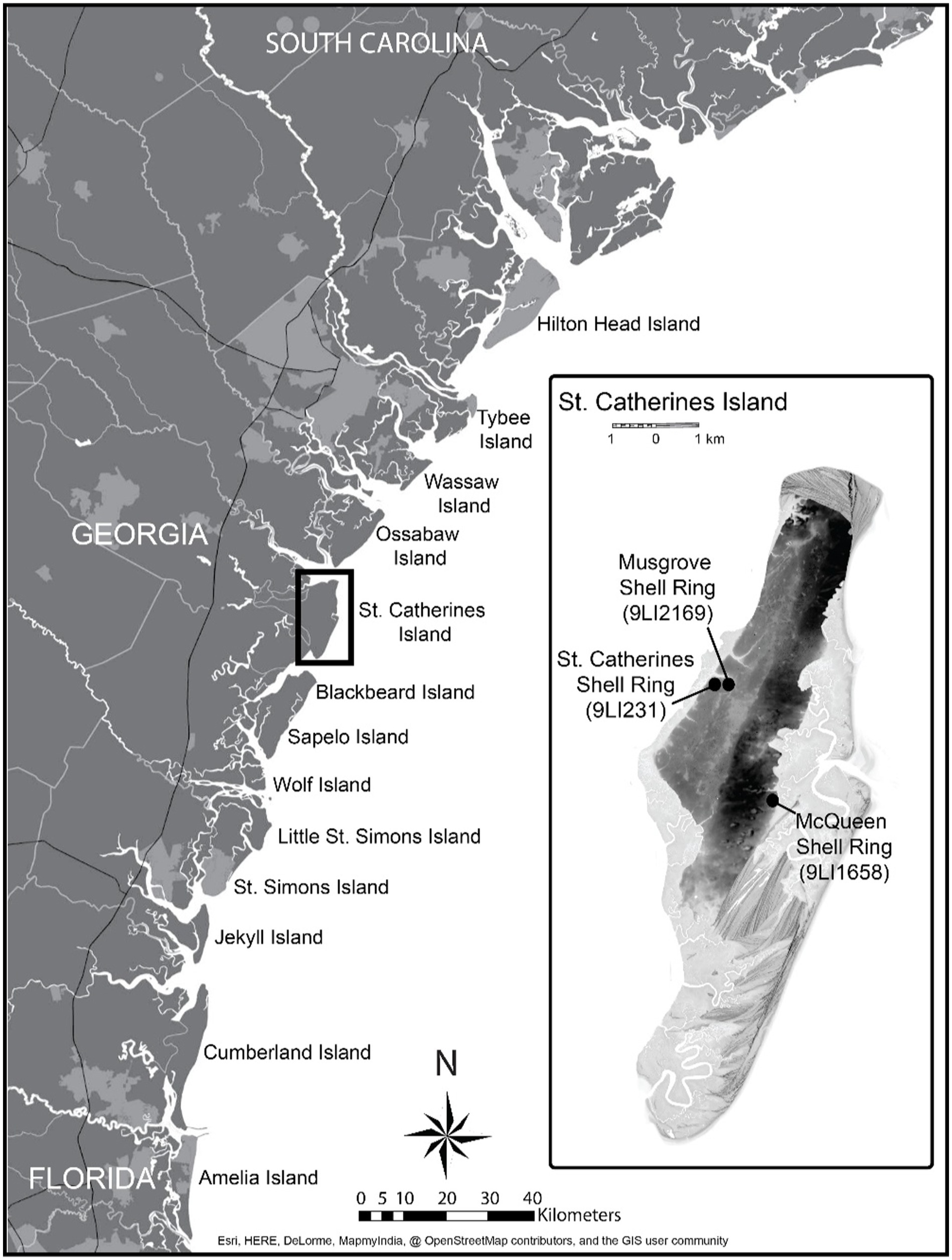
Figure 1. Map of the three rings on St. Catherines Island.
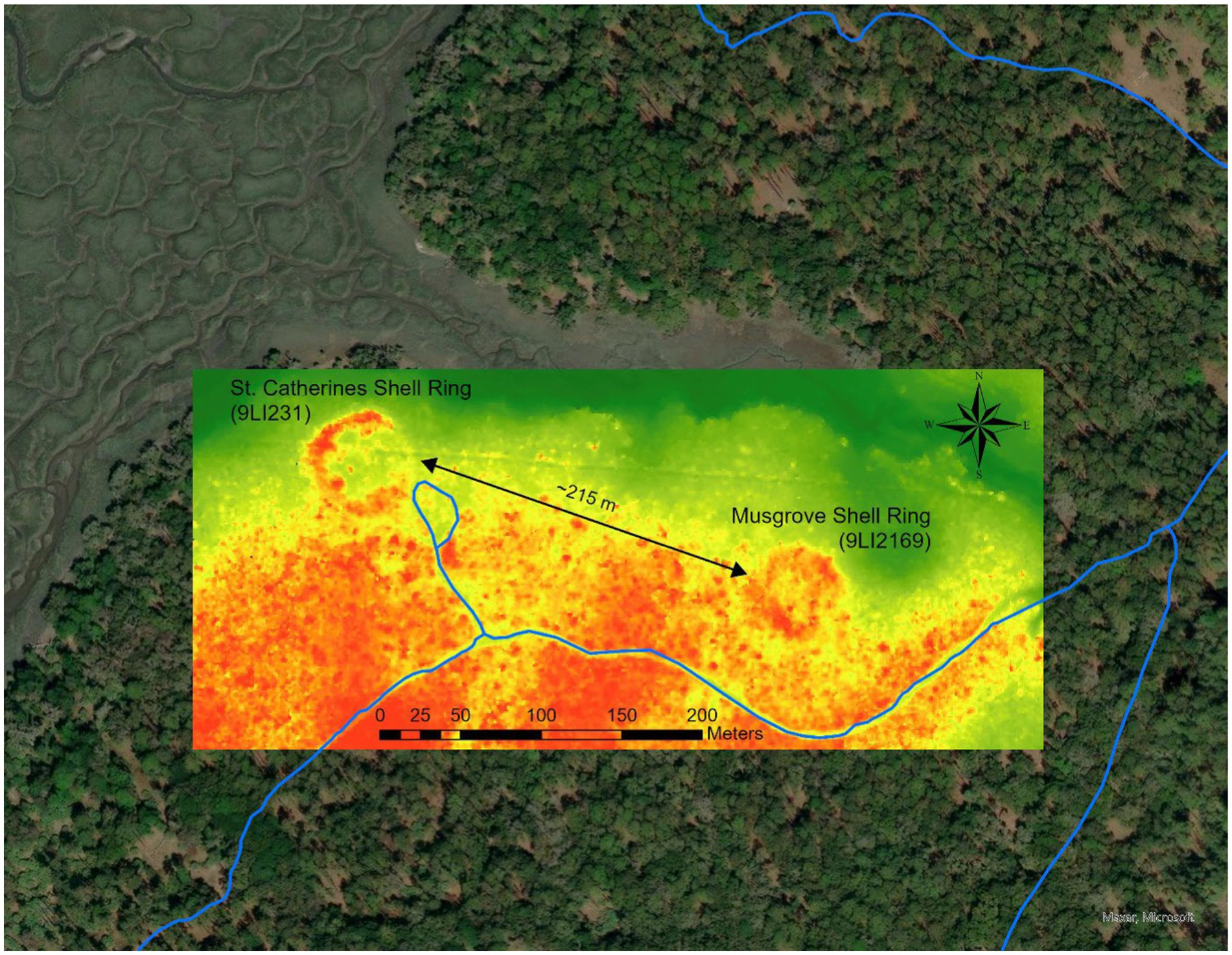
Figure 2. Lidar map of St. Catherines and Musgrove Shell Rings.
Shallow geophysical surveys were conducted to better understand the structure of the shell deposit. Minimally and non-invasive explorations included shell-probe surveys, magnetic gradiometer surveys, electrical resistance tomography, and time domain induced polarization confirm its open-circle, C-shape (Plattner et al., 2023).
One test pit, placed in the southern portion of the shell arc, confirms that unlike McQueen or St. Catherines, the Musgrove Shell Ring is arcuate in shape, with the southern portion free of shell.
We excavated three additional test pits across the shell-bearing portions of the shell arc, attempting to target the thickest shell deposits and test a diverse range of shell ring construction across the site. These limited excavations into the shell-bearing portions of the deposit were conducted primarily to collect radiocarbon samples that represent the full span of shell ring construction.
The shell layer was approximately 50 cm in thickness, although the original shell ring deposit was likely thicker prior to historic plowing. Samples were collected throughout the shell ring profile, including features within the shell, as well as samples underlying the shell deposit. Figure 3 shows the southern profile of Unit N2131 E4186, where six samples from Musgrove Shell Ring were collected for radiocarbon dating.

Figure 3. Unit N2131 E4186 from Musgrove Shell Ring, facing south. Test unit profile is 1 m across.
This unit had three features within the shell deposit that were radiocarbon dated. Features 1 and 2 were likely from the same depositional event and had identical radiocarbon dates. Feature 1 had large amounts of crushed shell and Feature 2 was organic soil with crushed shell and charcoal below Feature 1. This burned, crushed shell feature was approximately 10 cm thick and at least 60 cm in diameter. Feature 7, underlying these two features, consisted of dark, organic soil with some whole and crushed shell inclusions. Radiocarbon samples were also collected from the top and bottom of the shell ring deposit, as well as from the buried A horizon underlying the shell deposit.
Supplementary Table S1 lists the provenience for all samples. The stratigraphy and radiocarbon dating of the St. Catherines and McQueen Shell Rings have been discussed elsewhere (Sanger and Thomas, 2010; Kennett and Culleton, 2012; Sanger, 2015a).
2 Methods and materials
2.1 Radiocarbon dating and Bayesian modeling
Previous radiocarbon research using a summed probability approach indicate that the St. Catherines Shell Ring and the McQueen Shell Ring and were relatively contemporaneous, with both sites dating to c. 4,200–3,800 cal BP (Sanger and Thomas, 2010: 62–63). These summed probabilities suggest the simultaneous occupation of the sites over a long period of time.
Bayesian modeling allows us to use additional information, such as stratigraphic relationships, to potentially tighten these date ranges and better understand sequential relationships and start and end dates for specific deposits.
Initial Bayesian modeling on terrestrial and marine samples from both rings clarified the temporal relationship further, indicating that shell deposition at the St. Catherines Shell Ring began before the earliest deposits at the McQueen Shell Ring, and that construction and use at McQueen persisted later in time (Kennett and Culleton, 2012). The start of the McQueen Shell Ring deposition was estimated between 2,520 and 2,100 cal BC (4470–4,050 cal BP) which overlaps with dates from ring construction at the St. Catherines Shell Ring beginning at 2430–2200 cal BC (4380–4,150 cal BP). These data suggest an overlap of at least 200 years and indicate they are contemporary.
A higher resolution understanding of shell ring construction and the sequence of these communities is necessary to articulate the Musgrove Shell Ring within this chronological framework, and better understand the diversity of the shell ring communities, as evidenced by their material culture and morphology.
2.2 Sampling and methodology
We analyzed a total of 34 AMS radiocarbon dates on the three shell rings from St. Catherines Island: existing radiocarbon samples from the McQueen Shell Ring (n = 10), the St. Catherines Shell Ring (n = 10), as well as new radiocarbon dates from the Musgrove Shell Ring (n = 14). These dates are also included in our regional study on shell ring chronology (Thompson et al., 2024). Here, our presentation of the chronologies for St. Catherines Island specifically, provide a more detailed examination of how these chronologies are important to our understanding of shell ring villages at the island level. Furthermore, this also allows us to discuss the details of these dates in relation to the artifact assemblages at these rings, which was not possible in our regional study.
The radiocarbon samples selected for this study were terrestrial samples (bone, carbonized wood, and hickory nut) collected from shell deposits in the shell ring and features in the center of the shell ring. Similar to other subtropical environments in the Southeast U.S. with high temperatures, rainfall, and presence of biological agents of decay (Thompson et al., 2016), we assume decay rates of carbonized wood to be high enough that the “old wood problem” (Schiffer, 1986) will not significantly affect our results.
We chose to exclusively analyze terrestrial materials rather than compare terrestrial and marine samples where some dates would require a marine reservoir correction, which would contribute additional uncertainty to the calibrated date (Hadden et al., 2023). And, the lower-precision, wider calibrated ranges of marine samples can make it difficult to distinguish precise contemporaneity (Kennett and Culleton, 2012). This was one of the key challenges in previous dating studies from St. Catherines Island shell rings (Thomas, 2008; Sanger and Thomas, 2010; Kennett and Culleton, 2012; Sanger, 2015a).
For each of the shell rings, we constructed a series of Bayesian models on samples associated with shell ring deposition. While these models are also included in our larger regional study, here, we analyze them at the local scale, and in greater detail, in order to examine the relationships between St. Catherines Island rings specifically. Readers interested in the regional context of shell rings in the South Atlantic Bight are directed to Thompson et al. (2024).
Specific provenience information from each of the terrestrial radiocarbon samples collected from the three shell rings is published in Supplementary Table S1 (see also Thomas, 2008; Sanger and Thomas, 2010; Sanger, 2015a; Thompson et al., 2024). For this analysis, we used OxCal 4.4.4 (Buck et al., 1991; Bronk Ramsey, 2009) and the IntCal20 14C calibration curve (Reimer et al., 2020). These models are based on the types of samples as well as their contexts and stratigraphic ordering. The use of a priori information allowed us to construct models with date ranges that are more constrained than models with only simple calibration alone (Hamilton and Krus, 2017). Most of our models are straightforward simple Phase models which are detailed in the Supplementary Information. The models presented below represent the most likely scenario based on what we know about the archaeology of these shell rings. In particular, we used both a General and Charcoal outlier model for these final models which downweighs potential temporal outliers and accounts for some degree of inbuilt age. We also use a log-normal Interval command of 125 years which is based on our assessment of the duration of villages in the Eastern Woodlands, which typically do not exceed 100 to 200 years (see Hally, 2008; Cobb et al., 2015; Barrier, 2017; Manning and Birch, 2022). This constrains the site duration to 250 years which we previously argue is a conservative estimate for these sites (see Thompson et al., 2024 for a more detailed justification). We also used the KDE Plot command to provide a date range for the occupied ring, which we then used to compare using the Order command to return probability estimates for the order of these sites.
3 Results
All modeled dates are reported in italics and the structure of the models can be observed from the bracketed structure of the probability distribution plots (Figures 4–7) in addition to the runfiles provided in the Supplementary materials.
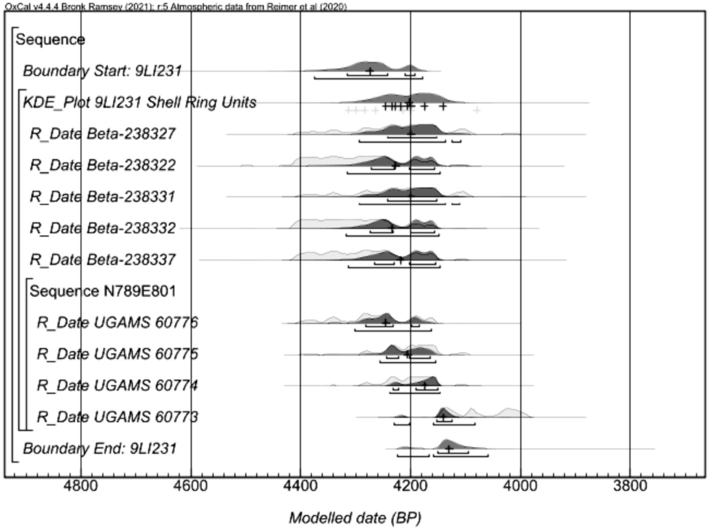
Figure 4. Modeled dates from St. Catherines Shell Ring.
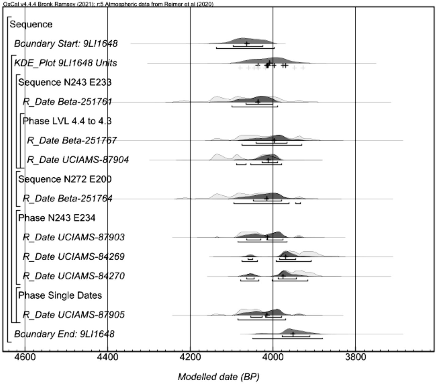
Figure 5. Modeled dates from McQueen Shell Ring.
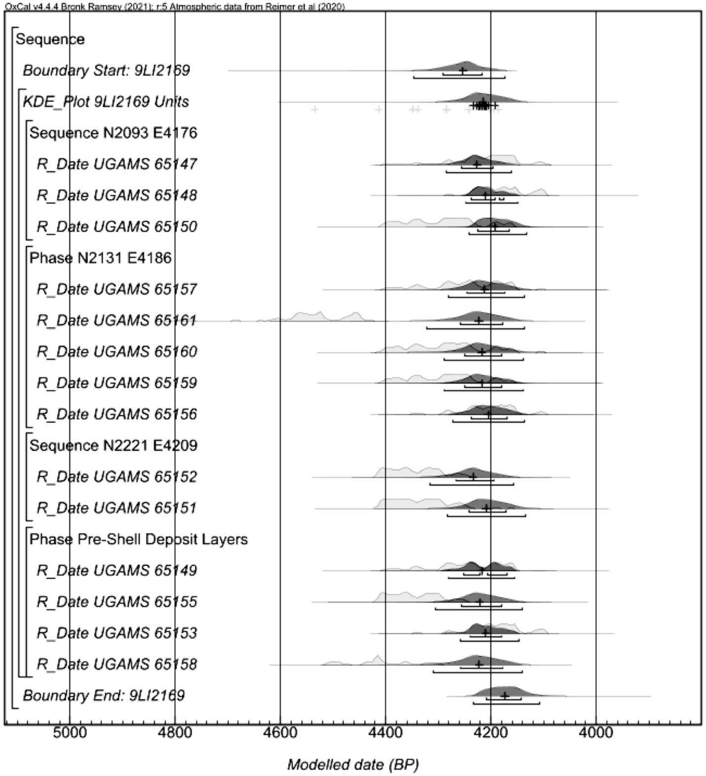
Figure 6. Modeled dates from Musgrove Shell Ring.
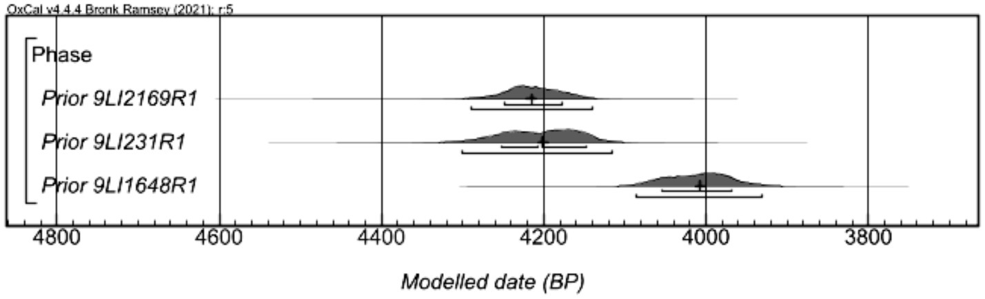
Figure 7. KDE modeled dates from the three rings.
3.1 St. Catherines Shell Ring
The modeled dates from the St. Catherines Shell Ring use samples collected from the shell deposit of the shell ring and include a sequence of samples in stratigraphic order.
The model (Supplementary Table S13) places the samples into one Phase and includes an ordered Sequence. A General Outlier model was applied to all the dates, and a Date command was applied to estimate the duration of the occupation of the site (see Supplemental Information for additional details and models). For models to be considered in OxCal to indicate good agreement between dates and the stipulated parameters, the Amodel agreement must exceed 60 (Bronk Ramsey, 1995). The Amodel (101.5) exceeds the value for good agreement and represents the best approximation of the dated contexts. The model did not identify any dating outliers.
The model shows that the start date of shell ring construction is 4,380–4,170 cal BP (95.4 hpd) and the end date is 4,230–4,060 cal BP (95.4 hpd) (Table 1). The KDE estimate range for the Phase is 4,310–4,110 cal BP (95.4 hpd) and the Interval of occupation is 10–280 years (95.3 hpd).
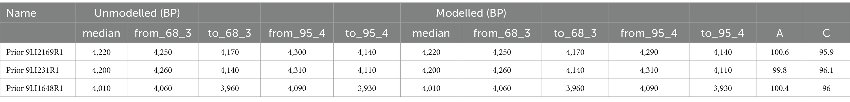
Table 1. Summary table of modeled dates for the three shell rings.
3.2 McQueen Shell Ring
The samples analyzed in this model are from shell-bearing units and features in the shell ring deposit. The order of the dates within each Sequence is the stratigraphic order of the samples. As with the St. Catherines Shell Ring model, a General Outlier model and a KDE command were applied (Supplementary Table S19). The Amodel (113.1) exceeds the value to indicate good agreement between the date and model and represents the best approximation of the dated contexts. The model did not identify any dating outliers.
The start date of construction is 4,140–3,990 cal BP (95.4 hpd) and the end date is 4,050–3,880 cal BP (95.4 hpd) (Table 1). The KDE estimate for the Phase is 4,090–3,930 cal BP (95.4 hpd) and the Interval of occupation is 20–230 years (95.3 hpd).
3.3 Musgrove Shell Ring
This model includes samples from levels associated shell deposition as well as samples from pre-ring deposits underlying the shell. There are several ordered sequences in this model, and a General Outlier model and a Date command were applied (Supplementary Table S7). The Amodel (100.5) exceeds the value for good agreement and represents the best approximation of the dated contexts. The model identified no outliers.
The start date is 4,350–4,160 cal BP (95.4 hpd) and the end date is 4,240–4,110 cal BP (95.4 hpd) (Table 1). The KDE estimate for the Phase is 4,290–4,140 cal BP (95.4 hpd) and the Interval of occupation is 0–190 years (95.3 hpd).
3.4 Comparison of the three shell rings
The summary table of the KDE Phase modeled dates from the three rings (Table 1) show there is significant overlap between the dates from the St. Catherines Shell Ring and the Musgrove Shell Ring. At the Musgrove Shell Ring, the date estimate for the Phase is 4,290–4,140 cal. BP (95.4 hpd), which is contemporaneous with the St. Catherines Shell Ring at 4310–4110 cal BP (95.4 hpd). The McQueen Shell Ring postdates both shell rings with Phase dates of 4,090–3,930 cal BP (95.4 hpd).
To further clarify this relationship, the KDE estimate of each site occupation from the models were placed in a single phase with the Order command. We took the posterior probability for the duration of each of the rings to assess the chronological relationship between each of the rings. Table 2 presents the probabilities of these relationships. Based on this analysis, there is a high probability that the McQueen Shell Ring post-dates the St. Catherines Shell Ring and the Musgrove Shell Ring (>99%, both), and the St. Catherines Shell Ring and the Musgrove Shell Ring are contemporaneous.
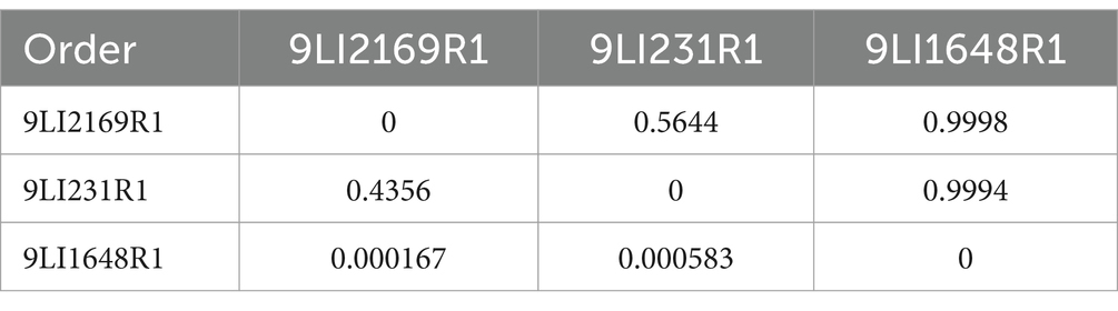
Table 2. Probability of chronological relationships between the shell rings.
4 Discussion
Previous radiocarbon analyses of the Late Archaic on St. Catherines Island, which included dates derived from archaeological shell, suggest that the St. Catherines Shell Ring and the McQueen Shell Ring were contemporaneous (Sanger and Thomas, 2010; Kennett and Culleton, 2012; Sanger, 2015a). While this work was a first step in putting these shell rings’ temporalities into more detailed focus, our new modeling of dates entirely obtained from terrestrial samples help refine our previous interpretations of the two communities of shell-ring inhabitants on each side of the island.
These results are consistent with previous assertions that the shell arcs accumulated over several decades to a full century after an earlier use of the site (Kennett and Culleton, 2012; Sanger, 2015a). And, according to this new research, although their morphologies differ, the temporality of accumulation of shell was roughly similar for each of the three shell rings.
This research shows that the McQueen Shell Ring post-dates the St. Catherines Shell Ring, which allows us to enhance our interpretations of the material culture from each site. These differences in the manufacture and decorative traditions of fiber-tempered pottery, lithic material sources, cooking technology, and construction practices between the rings, which researchers previously interpreted as being the result of contemporaneous communities with different practices of lithic procurement, food preparation, and technology, we attribute instead to communities transformed by time.
Specifically, there are key differences among these communities that link into larger processes. First, St. Catherines and Musgrove are among the earliest rings in the region that also have evidence of pottery production (Thompson et al., 2024). The chronology data and the proximity of the St. Catherines Shell Ring and the Musgrove Shell Ring indicate that the people living at these sites were co-residents. And, the large amount of plain pottery sherds and baked clay objects from St. Catherines demonstrate that inhabitants were on the forefront of pottery production in the region (see Sanger, 2016). As Sanger (2016:595–596) notes the most common method of pottery construction at St. Catherines Shell Ring is “dual-fold slab building, which is relatively rare at McQueen,” where there was a greater prevalence of “homogenous slab-building.” Further, the later McQueen Ring not only has more diverse pottery production techniques, there is also an absence of baked clay objects and a significantly higher frequency of decorated pottery. Finally, the sheer quantity of pottery sherds (> 40,000) indicate that pottery production and experimentation was in full swing by the time the McQueen Shell Ring community inhabited the island. Thus, in terms of settling down, the duration of more permanent villages on the landscape likely had an overarching influence on technological changes within these communities. While such detailed studies of material culture for the Musgrove Shell Ring are ongoing, future research within this new understanding of how cultural traditions at shell rings on St. Catherines Island have transformed over time will allow archaeologists to test models and assumptions regarding these broader patterns of material culture and community organization.
Furthermore, this iterative research in radiocarbon using Bayesian modeling is key in refining the timing of construction and abandonment, helping us to securely articulate the timing of site use with environmental change, including sea-level change. Because this research more precisely defines the phase of occupation at the shell ring sites rather than changing the previously accepted date ranges for the shell rings, the results lend further support to previous hypotheses about shell ring abandonments correlating to a drop in sea-levels after 4,200 cal BP, culminating in the abandonment of shell ring villages by 3,800 cal BP along the Georgia Coast (Gayes et al., 1992; Turck and Thompson, 2016). The proximity of the Musgrove Shell Ring to the St. Catherines Shell Ring, as well as the similarity in elevation and landscape, further supports the idea that this wave of shell ring abandonments occurring at this time is, in fact, correlated to elevation above sea-level and proximity to marsh resources (Sanger, 2010).
Previous research on the shell ring communities at St. Catherines Island suggest Late Archaic people on the coast adopted a complex settlement strategy, where groups aggregated at villages for large-scale gatherings during the winter (Sanger and Ogden, 2018; Sanger et al., 2020). Refining this chronology and connecting it to data from the material culture at these different villages will allow us to test this seasonal model at a solidly contemporaneous village.
This case study highlights the importance of high precision temporal analysis of shell rings and can tell us more about the timing of people living in these persistent and contemporary communities and shows the diversity of sedentary models among pre-agricultural communities on the coast. Specifically, this work highlights the fact that the process of settling down is more complicated and involved than simply the emergence of villages. In the case of St. Catherines Island, multiple communities (i.e., the St. Catherines and Musgrove rings) both inhabited the island at the same time and subsequently reinhabited the island later (the McQueen ring). In each of these instances, shell ring inhabitants would have had to negotiate different social and ecological landscapes for village life to continue to be viable. Understanding the timing of these communities is thus critical to begin to explore the attendant challenges that these earliest settled communities faced on both short- and long-term time scales.
Data availability statement
The original contributions presented in the study are included in the article/Supplementary material, further inquiries can be directed to the corresponding author.
Author contributions
RC: Writing – original draft, Writing – review & editing. MS: Writing – original draft. AS: Writing – original draft. VT: Writing – original draft. CG: Writing – original draft. EB: Writing – original draft. DT: Writing – original draft.
Funding
The author(s) declare financial support was received for the research, authorship, and/or publication of this article. This research was supported, in part, in association with the Georgia Coastal Ecosystems LTER project and by National Science Foundation grants awarded to Thompson and Sanger (NSF Grants OCE-0620959, OCE-123714, NSF-1748276), the Edward John Noble Foundation, the St. Catherines Island Foundation, and the University of Alabama. The funders had no role in study design, data collection and analysis, decision to publish, or preparation of the manuscript.
Acknowledgments
The Edward John Noble and St. Catherines Island Foundations, the St. Catherines Island staff, the 2023 University of Alabama Archaeological Field School students, and the St. Catherines Island Archaeology crew, including Lorann Pendleton, Thomas Blaber, Abigail Musch, Caitria O’Shaughnessy, and Diana Rosenthal Roberson. We also thank two reviewers for their comments which improved this manuscript.
Conflict of interest
The authors declare that the research was conducted in the absence of any commercial or financial relationships that could be construed as a potential conflict of interest.
The author(s) declared that they were an editorial board member of Frontiers, at the time of submission. This had no impact on the peer review process and the final decision.
Publisher’s note
All claims expressed in this article are solely those of the authors and do not necessarily represent those of their affiliated organizations, or those of the publisher, the editors and the reviewers. Any product that may be evaluated in this article, or claim that may be made by its manufacturer, is not guaranteed or endorsed by the publisher.
Supplementary material
The Supplementary material for this article can be found online at: https://www.frontiersin.org/articles/10.3389/fhumd.2024.1358614/full#supplementary-material
References
Andrus, C. F. T., and Thompson, V. D. (2012). Determining the habitats of mollusk collection at the Sapelo Island shell ring complex, Georgia, USA using oxygen isotope sclerochronology. J. Archaeol. Sci. 39, 215–228. doi: 10.1016/j.jas.2011.08.002
Barrier, C. R. (2017). Town aggregation and abandonment during the era of urban transformations in the Cahokia region: Bayesian modeling of the Washausen mound-town. J. Archaeol. Sci. Rep. 11, 523–535. doi: 10.1016/j.jasrep.2016.12.027
Bronk Ramsey, C. (1995). Radiocarbon calibration and analysis of stratigraphy: the OxCal program. Radiocarbon 37, 425–430. doi: 10.1017/S0033822200030903
Bronk Ramsey, C. (2009). Bayesian analysis of radiocarbon dates. Radiocarbon 51, 337–360. doi: 10.1017/S0033822200033865
Buck, C. E., Kenworthy, J. B., Litton, C. D., and Smith, A. F. (1991). Combining archaeological and radiocarbon information: a Bayesian approach to calibration. Antiquity 65, 808–821. doi: 10.1017/S0003598X00080534
Cajigas, R., Sanger, M. C., and Thompson, V. D. (2023). Cross-mended ceramic sherds as a proxy for depositional processes at two late archaic shell rings in coastal Georgia. Southeast. Archaeol. 42, 178–193. doi: 10.1080/0734578x.2023.2213544
Cannarozzi, N. R. (2012). “Estimating the season of harvest of the eastern oyster (Crassotrea virginica) from the St. Catherines Shell ring” in Seasonality and human mobility along the Georgia Bight. eds. E. J. Reitz, I. R. Quitmyer, and D. H. Thomas, vol. 97 (New York: Anthropological Papers of the American Museum of Natural History), 171–185.
Cannarozzi, N. R., and Kowalewski, M. (2019). Seasonal oyster harvesting recorded in a late archaic period shell ring. PLoS One 14:e0224666. doi: 10.1371/journal.pone.0224666
Cobb, C. R., Krus, A. M., and Steadman, D. W. (2015). Bayesian modeling of the occupation span of the Averbuch site in the middle Cumberland drainage, Tennessee. Southeast. Archaeol. 34, 46–56. doi: 10.1179/2168472314Y.0000000005
Colaninno, C. E. (2011a). Zooarchaeological analysis of vertebrate remains from five late archaic shell rings on the Georgia coast, USA. Dissertation. Athens (GA): University of Georgia.
Colaninno, C. E. (2011b). Examining ichthyofaunal remains for evidence of fishing technologies employed in Georgia estuaries during the late archaic period. Southeast. Archaeol. 30, 337–350. doi: 10.1179/sea.2011.30.2.008
Colaninno, C. E. (2012a). “Evaluating δ18O profiles of hardhead catfish and Atlantic croaker otoliths as a method of determining seasonal use of fishes” in Seasonality and human mobility along the Georgia Bight. eds. E. J. Reitz, I. R. Quitmyer, and D. H. Thomas, vol. 97 (New York: Anthropological Papers of the American Museum of Natural History), 83–101.
Colaninno, C. E. (2012b). Evaluating formational models for late archaic Shell rings of the southeastern United States using vertebrate Fauna from the St. Catherines Shell ring, St. Catherines Island, Georgia. J. Island Coast. Archaeol. 7, 338–362. doi: 10.1080/15564894.2012.708008
Colaninno, C. E. (2022). Foodways of the late archaic people of St. Catherines Island, Georgia: an analysis of vertebrate remains from two shell rings. Southeast. Archaeol. 41, 183–199. doi: 10.1080/0734578x.2022.2099042
Colaninno, C. E., and Compton, J. M. (2018). Integrating vertebrate and invertebrate season of capture data from ring III of the Sapelo Island Shell ring complex (9MC23), Georgia, USA. J. Isl. Coast. Archaeol. 14, 560–583. doi: 10.1080/15564894.2018.1458763
Colaninno, C. E., and Reitz, E. J. (2015) Animal remains from two late archaic Shell rings on St. Catherines Island, Georgia, Manuscript on file, Georgia Museum of Natural History, University of Georgia, Athens.
DePratter, C. B., and Thompson, V. D. (2013). “Past shorelines of the Georgia coast” in Life among the tides: Recent archaeology on the Georgia Bight. eds. V. D. Thompson and D. H. Thomas, vol. 98 (New York, NY: Anthropological papers of the American Museum of Natural History), 145–167.
Garland, C. J., and Thompson, V. D. (2023). Collective action and shellfish harvesting practices among late archaic villagers of the South Atlantic Bight. J. Anthropol. Archaeol. 69:101483. doi: 10.1016/j.jaa.2022.101483
Garland, C. J., Thompson, V. D., Sanger, M. C., Smith, K. Y., Andrus, F. T., Lawres, N. R., et al. (2022). A multi-proxy assessment of the impact of environmental instability on late Holocene (4500-3800 BP) native American villages of the Georgia coast, USA. PloS one 17:e0258979. doi: 10.1371/journal.pone.0258979
Gayes, P. T., Scott, D. B., Collins, E. S., and Nelson, D. D. (1992). “Late holocene sea-level fluctuation in south carolina” in Quaternary Coasts of the United States: Marine and Lacustrine Systems, SEPM Society for Sedimentary Geology Special Publication No. 48. eds. C. H. Fletcher and J. F. Wehmiller (Tulsa: Society for Sedimentary Geology), 155–160. doi: 10.1007/978-94-007-4026-6-4
Hadden, C. S., Hutchinson, I., and Martindale, A. (2023). Dating marine Shell: a guide for the wary north American archaeologist. Am. Antiq. 88, 62–78. doi: 10.1017/aaq.2022.82
Hally, D. (2008) King: The social archaeology of a late Mississippian town in northwestern Georgia. (Tuscaloosa: University of Alabama Press).
Hamilton, W. D., and Krus, A. M. (2017). The myths and realities of Bayesian chronological modeling revealed. Am. Antiq. 83, 1–17. doi: 10.1017/aaq.2017.57
Kennett, D., and Culleton, B. J. (2012). “A Bayesian chronological framework for determining site seasonality and contemporaneity” in Seasonality and human mobility along the Georgia Bight. eds. E. J. Reitz, I. R. Quitmyer, and D. H. Thomas, vol. 97 (New York: Anthropological Papers of the American Museum of Natural History), 37–50.
Mahar, G. J. (2013). “Archaeological geophysics on St. Catherines Island: beyond prospection” in Life among the tides: Recent archaeology on the Georgia Bight. eds. V. D. Thompson and D. H. Thomas, vol. 98 (New York: Anthropological Papers of the American Museum of Natural History), 75–93.
Manning, S. W., and Birch, J. A. (2022). Centennial ambiguity: the challenge of resolving the date of the Jean-Baptiste Lainé (mantle), Ontario, site—around AD 1500 or AD 1600?—and the case for wood-charcoal as a terminus post quem. Radiocarbon 64, 279–308. doi: 10.1017/RDC.2022.23
Marrinan, R. A. (2010). “Two late archaic period Shell rings, St. Simon’s island, Georgia.” In Trend, tradition, and turmoil: What happened to the southeastern archaic?, edited by D. H. Thomas and M. C. Sanger, 71–102. New York, NY: American Museum of Natural History Anthropological Papers 93.
Partners, O. C. M. (2023). 2018–2019 USGS Lidar: GA statewide from 2010-06-15 to 2010-08-15 NOAA National Centers for Environmental Information Available at: https://www.fisheries.noaa.gov/inport/item/67264.
Plattner, A., Blair, E., Semon, A. M., Cajigas, R., Blaber, T., Sanger, M. C., et al. (2023). “Geophysical investigation of a ~45000 year old native American Shell ring” in Presentation in advances in geophysical methods for archaeology, forensic and anthropological targets at the American Geopysical union fall meeting, Decemeber 11–15, 2023 (San Fransisco, CA: American Geophysical Union).
Quitmyer, I. R., and Jones, D. S. (2012). “Annual incremental Shell growth patterns in hard clams (Mercenaria spp.) from St. Catherines Island, Georgia: a record of seasonal and Anthropogenetic impact on Zooarchaeological resources” in Seasonality and human mobility along the Georgia Bight. eds. E. J. Reitz, I. R. Quitmyer, and D. H. Thomas (New York: Anthropological Papers of the American Museum of Natural History), 135–148.
Quitmyer, I. R., Jones, D. S., and Arnold, W. S. (1997). The sclerochronology of hard clams, mercenariaspp., from the South-Eastern USA: a method of elucidating the zooarchaeological records of seasonal resource procurement and seasonality in prehistoric shell middens. J. Archaeol. Sci. 24, 825–840. doi: 10.1006/jasc.1996.0163
Reimer, P., Austin, W. E. N., Bard, E., Bayliss, A., Blackwell, P., Ramsey, C. B., et al. (2020). The Int Cal 20 northern hemisphere radiocarbon age calibration curve (0-55 kcal BP). Radiocarbon 62, 725–757. doi: 10.1017/RDC.2020.41
Reitz, E. J. (2008). “Nonhuman Vertebrate Remains” in Native American landscapes of St. Catherines Island, Georgia. ed. D. H. Thomas, vol. 88 (New York: Anthropological Papers of the American Museum of Natural History), 615–665.
Reitz, E. J. (2014). Continuity and resilience in the Central Georgia Bight (USA) fishery between 2760 BC and AD 1580. J. Archaeol. Sci. 41, 716–731. doi: 10.1016/j.jas.2013.10.004
Reitz, E. J., Colaninno, C. E., Quitmyer, I. R., and Cannarozzi, N. R. (2022). A 4, 000-year record of multifaceted fisheries in the Central Georgia Bight (USA). Southeast. Archaeol. 41, 253–270. doi: 10.1080/0734578x.2022.2134084
Ruhl, D.L. (2015) Plant husbandry practices revealed at two “sister” archaic period Shell ring sites on St. Catherines Island, Georgia, Manuscript on file, division of anthropology, American Museum of Natural History. New York.
Russo, M. (1991) “Archaic Sedentism on the Florida coast: A case study from Horr’s island.” PhD. dissertation, Gainesville: Department of Anthropology, University of Florida, Gainesville.
Russo, M. (2004). “Measuring Shell rings for social inequality” in Signs of power: The rise of cultural complexity in the southeast. eds. J. L. Gibson and P. J. Carr (Tuscaloosa: The University of Alabama Press), 26–70.
Russo, M. (2006). “Archaic Shell rings of the southeast U.S.” in National historic landmarks historic context (Tallahassee: Southeast Archaeological Center, National Park Service)
Russo, M. (2014). “Ringed Shell features of the southeastern United States” in The cultural dynamics of Shell-matrix sites. eds. M. Roksandic, S. Mendonca de Souza, S. Eggers, M. Burchell, and D. Klokler (Albuquerque: University of New Mexico Press), 21–39.
Russo, M., and Heide, G. (2001). Shell rings of the southeast US. Antiquity 75, 491–492. doi: 10.1017/S0003598X00088591
Sanger, M. C. (2010). “Leaving the rings: Shell ring abandonment and the end of the late archaic” in Trend, tradition, and turmoil: What happened to the southeastern archaic? eds. D. H. Thomas and M. C. Sanger, vol. 93 (New York, NY: American Museum of Natural History Anthropological Papers), 201–215.
Sanger, M. C. (2015a). Life in the round: Shell rings of the Georgia Bight. Ph. D. Dissertation New York, NY: Columbia University.
Sanger, M. C. (2015b). Determining depositional events within shell deposits using computer vision and photogrammetry. J. Archaeol. Sci. 53, 482–491. doi: 10.1016/j.jas.2014.10.026
Sanger, M. C. (2016). Investigating pottery vessel manufacturing techniques using radiographic imaging and computed tomography: studies from the late archaic american southeast. J. Archaeol. Sci. 9, 586–598.
Sanger, M. C. (2017a). Coils, slabs, and molds: examining community affiliation between late archaic shell ring communities using radiographic imagery of pottery. Southeast. Archaeol. 36, 95–109. doi: 10.1080/0734578X.2016.1267466
Sanger, M. C. (2017b). Evidence for significant subterranean storage at two hunter-gatherer sites: the presence of a mast-based economy in the late archaic coastal American southeast. Am. Antiq. 82, 50–70. doi: 10.1017/aaq.2016.6
Sanger, M. C., and Ogden, Q.-M. (2018). Determining the use of late archaic shell rings using lithic data: “ceremonial villages” and the importance of stone. Southeast. Archaeol. 37, 232–252. doi: 10.1080/0734578X.2017.1398995
Sanger, M. C., Padgett, B. D., Larsen, C. S., Hill, M., Lattanzi, G. D., Colaninno, C. E., et al. (2019). Great Lakes copper and shared mortuary practices on the Atlantic Coast: implications for long-distance exchange during the late archaic. Am. Antiq. 84, 591–609. doi: 10.1017/aaq.2019.59
Sanger, M. C., Quitmyer, I. R., Colaninno, C. E., Cannarozzi, N., and Ruhl, D. L. (2020). Multiple-proxy seasonality indicators: an integrative approach to assess Shell Midden formations from late archaic Shell rings in the coastal Southeast North America. J. Isl. Coast. Archaeol. 15, 333–363. doi: 10.1080/15564894.2019.1614116
Sanger, M. C., and Thomas, D. H. (2010). “The two rings of St. Catherines Island: some preliminary results from the St. Catherines and McQueen Shell ring” in Trend, tradition, and turmoil: What happened to the southeastern archaic? eds. D. H. Thomas and M. C. Sanger, vol. 93 (New York, NY: American Museum of Natural History Anthropological Papers), 45–69.
Saunders, R. (2002). "The Fig Island ring complex (38CH42): Coastal adaptation and the question of ring function in the late archaic," (Columbia, SC: South Carolina Department of Archives and History).
Saunders, R. (2004). The stratigraphic sequence at Rollins Shell ring: implications for ring function. Fla. Anthropol. 57, 249–268.
Saunders, R. (2014). “Shell rings of the lower Atlantic coast of the United States” in The cultural dynamics of Shell-matrix sites. eds. M. Roksandic, S. Mendonça de Souza, S. Eggers, M. Burchell, and D. Klokler (Albuquerque: University of New Mexico Press), 41–55.
Saunders, R., and Russo, M. (2011). Coastal shell middens in Florida: a view from the archaic period. Quat. Int. 239, 38–50. doi: 10.1016/j.quaint.2010.08.008
Schiffer, M. B. (1986). Radiocarbon dating and the “old wood” problem: the case of the Hohokam chronology. J. Archaeol. Sci. 13, 13–30. doi: 10.1016/0305-4403(86)90024-5
Thomas, D. H. (2008). Native American landscapes of St. Catherines Island, Georgia. New York: American Museum of Natural History, 88.
Thomas, D. H. (2014). The shellfishers of St. Catherines Island: hardscrabble foragers or farming beachcombers? J Isl Coast. Archaeol. 9, 169–182. doi: 10.1080/15564894.2013.840874
Thomas, D. H., Kick, M., Sanger, M. C., and Semon, A. M. (2008). “Terrestrial foraging on St. Catherines Island” in Native American landscapes of St. Catherines Island, Georgia. ed. D. H. Thomas, vol. 88 (New York: Anthropological Papers of the American Museum of Natural History), 136–197.
Thompson, V. D. (2007). Articulating activity areas and formation processes at the Sapelo Island Shell ring complex. Southeast. Archaeol. 26, 91–107.
Thompson, V. D. (2018). “Collective action and village life during the late archaic on the Georgia coast” in The archaeology of villages in eastern North America. eds. J. Birch and V. D. Thompson (Gainesville: University Press of Florida), 20–35.
Thompson, V. D. (2022). Considering ideas of collective action, institutions, and “hunter-gatherers” in the American southeast. J. Archaeol. Res. 31, 503–560. doi: 10.1007/s10814-022-09179-3
Thompson, V. D., and Andrus, C. F. T. (2011). Evaluating mobility, monumentality, and feasting at the Sapelo Island Shell ring complex. Am. Antiq. 76, 315–343. doi: 10.7183/0002-7316.76.2.315
Thompson, V. D., Marquardt, W. H., Cherkinsky, A., Roberts Thompson, A. D., Walker, K. J., Newsom, L. A., et al. (2016). From shell midden to midden-mound: the geoarchaeology of mound key, an anthropogenic island in Southwest Florida, USA. PloS one 11:e0154611. doi: 10.1371/journal.pone.0154611
Thompson, V. D., Reynolds, M. D., Haley, B., Jefferies, R., Johnson, J. K., and Humphries, L. (2004). The Sapelo shell ring complex: shallow geophyscis on a Georgia Sea island. Southeast. Archaeol. 23, 192–201.
Thompson, V. D., Rick, T., Garland, C. J., Thomas, D. H., Smith, K. Y., Bergh, S., et al. (2020). Ecosystem stability and native American oyster harvesting along the Atlantic Coast of the United States. Sci. Adv. 6:eaba9652. doi: 10.1126/sciadv.aba9652
Thompson, V. D., Smith, K. Y., Sanger, M., Garland, C. J., Pluckhahn, T. J., Napora, K., et al. (2024). Understanding the dynamics of village life along the South Atlantic Coast (ca. 5000 to 3000 years BP). Sci. Rep. 14:4691. doi: 10.1038/s41598-024-55047-z
Thompson, V. D., and Turck, J. A. (2009). Adaptive cycles of coastal hunter-gatherers. Am. Antiq. 74, 255–278. doi: 10.1017/S0002731600048599
Thompson, V. D., and Worth, J. E. (2011). Dwellers by the sea: native American adaptations along the southern coasts of eastern North America. J. Archaeol. Res. 19, 51–101. doi: 10.1007/s10814-010-9043-9
Trinkley, M. B. (1985). “The form and function of South Carolina’s early woodland Shell rings” in Structure and process in southeastern archaeology. eds. R. S. Dickens and H. T. Ward (Tuscaloosa: University of Alabama Press), 102–118.
Turck, J. A., and Alexander, C. R. (2013). “Coastal landscapes and their relationship to human settlement on the Georgia coast” in Life among the tides: Recent archaeology on the Georgia. eds. V. D. T. Bight and D. H. Thomas, vol. 98 (New York: Anthropological papers of the American Museum of Natural History), 169–189.
Keywords: archaeology, radiocarbon dating, Bayesian modeling, southeast U.S., Late Archaic
Citation: Cajigas R, Sanger MC, Semon AM, Thompson VD, Garland CJ, Blair EH and Thomas DH (2024) Sequential villages and settling down on the southeast U.S. coast. Front. Hum. Dyn. 6:1358614. doi: 10.3389/fhumd.2024.1358614
Edited by:
David Manuel Carballo, Boston University, United StatesReviewed by:
Chris Rodning, Tulane University, United StatesRichard Edward Blanton, Purdue University, United States
Copyright © 2024 Cajigas, Sanger, Semon, Thompson, Garland, Blair and Thomas. This is an open-access article distributed under the terms of the Creative Commons Attribution License (CC BY). The use, distribution or reproduction in other forums is permitted, provided the original author(s) and the copyright owner(s) are credited and that the original publication in this journal is cited, in accordance with accepted academic practice. No use, distribution or reproduction is permitted which does not comply with these terms.
*Correspondence: Rachel Cajigas, cm1jYWppZ2FzQHVhLmVkdQ==