 Nathan A. Miller
 Aaron Roan2
- 1SkyTruth, Shepherdstown, WV, United States
- 2Google, Mountain View, CA, United States
- 3Global Fishing Watch, Washington, DC, United States
Transshipment at sea, the offloading of catch from a fishing vessel to a refrigerated vessel far from port, can obscure the actual source of the catch, complicating sustainable fisheries management, and may allow illegally caught fish to enter the legitimate seafood market. Transshipment activities often occur in regions of unclear jurisdiction where policymakers or enforcement agencies may be slow to act against a challenge they cannot see. To address this limitation, we processed 32 billion Automatic Identification System (AIS) messages from ocean-going vessels from 2012 to the end of 2017 and identified and tracked 694 cargo vessels capable of transshipping at sea and transporting fish (referred to as transshipment vessels). We mapped 46,570 instances where these vessels loitered at sea long enough to receive a transshipment and 10,233 instances where we see a fishing vessel near a loitering transshipment vessel long enough to engage in transshipment. We found transshipment behaviors associated with regions and flag states exhibiting limited oversight; roughly 47% of the events occur on the high seas and 42% involve vessels flying flags of convenience. Transshipment behavior in the high seas is relatively common, with vessels responsible for 40% of the fishing in the high seas having at least one encounter with a transshipment vessel in this time period. Our analysis reveals that addressing the sustainability and human rights challenges (slavery, trafficking, bonded labor) associated with transshipment at sea will require a global perspective and transnational cooperation.
Introduction
A transshipment occurs when two vessels meet to exchange cargo, supplies, or personnel, often between vessels at sea and far from a home port. By allowing fishing vessels to offload catch at sea and remain on the fishing grounds, transshipment consolidates fuel costs within a fleet and moves product to market more efficiently. However, transshipment also introduces concerns over traceability and transparency in the seafood industry. The Food and Agriculture Organization (FAO) of the United Nations estimates over 15% of annual global catch is illegal, unreported, or unregulated (IUU) (Food Agriculture Organization of the United Nations, 2016). Transshipment has also been linked to human trafficking and can allow captains to keep their crew at sea indefinitely, resulting in de facto slavery (McDowell et al., 2015). Through transshipment, players in the industry can access reputable markets by mixing illegally caught fish with legal product during transshipments (Environmental Justice Foundation, 2013). The practice obscures supply chains and prevents an accurate measurement of the amount of marine life being taken from the sea, thus limiting our ability to fish the ocean sustainably.
Policies on transshipment vary by Exclusive Economic Zone (EEZ), flag state, and region (McCoy, 2012), making it difficult to characterize global and regional patterns of transshipment. Even in regions that have adopted regulations on transshipment activities, these regulations may be relatively opaque. For example, in the Western and Central Pacific Fisheries Commission (WCPFC) convention area, which has implemented relatively robust management plans (Ewell et al., 2017), the measures regarding transshipment simultaneously restrict transshipment and provide opportunities to circumvent the restrictions. In this region, reporting is the responsibility of each vessel's flag state, which may be a flag of convenience exercising little oversight (WCPFC, 2009). In comparison, The Forum Fisheries Agency (FFA) and Convention for the Conservation of Antarctic Marine Living Resources (CCAMLR) have a comprehensive monitoring scheme, independent verification of catch and transshipment, capacity to monitor and enforce conservation measures, and the opportunity to investigate transnational criminal activities (CCAMLR, 2011, 2016; FFA, 2016). The South East Atlantic Fisheries Organization (SEAFO) has gone even further by prohibiting all transshipment at sea by convention members operating within the convention area (SEAFO, 2017). However, even in the regions that have adopted transshipment regulations, data on transshipments is tightly held and often viewed as sensitive business information. In other regions, transshipments appear to occur with little to no independent observer coverage, verification of transshipped catch, or monitoring of potential transnational criminal activities. In both West African waters (INTERPOL, 2014; Daniels et al., 2016) and the squid fishery in the northwest Indian Ocean (Greenpeace, 2016; Stop Illegal Fishing et al., 2017), weak regulation and enforcement raise severe concerns regarding transshipment given its links to IUU fishing and criminal activities (UNDOC, 2016).
While regulations and policies may not provide a clear understanding of transshipment practices, new vessel tracking technologies can reveal the actual behavior of transshipment vessels. The Automatic Identification System (AIS), originally developed as a ship-to-ship transmission to prevent at-sea collisions, transmits a vessel's position every 2 s to 3 min via VHF radio (International Telecommunication Union (ITU), 2014). The International Maritime Organization (IMO) stipulates that all vessels larger than 300 gross tons on international voyages carry and operate an AIS device (IMO, 2002). For fishing vessels, this generally means that vessels over 37 m are required to carry AIS (Kroodsma et al., 2018). Some jurisdictions such as the EU and United States have enacted stricter requirements, with vessels over 15 and 19 m, respectively being required to carry AIS (McCauley et al., 2016). AIS messages can be received by satellites or a network of terrestrial antennas, which in turn allow for global tracking of vessels at sea. There are limitations to AIS, including the inability of satellites to resolve AIS messages in crowded regions of the ocean and the ability for operators to turn off the AIS device or broadcast incorrect identity information (Daniels et al., 2016; Kroodsma et al., 2018). In general, larger, less maneuverable vessels such as cargo vessels will be less prone to turning off AIS as they may be at greater risk of collision, a fact that may influence the consistency with which vessels are observed via AIS. Despite these limitations AIS provides an unprecedented view of fishing vessels and fishing activity (Kroodsma et al., 2018) and as an open-source tool represents a valuable means of promoting fisheries transparency.
In this paper, we present two methodologies for tracking transshipment behavior. The first detects where fishing vessels encounter transshipment cargo vessels at sea (hereafter referred to as “transshipment vessels”), with both vessels consistently broadcasting their positions via AIS. The second methodology identifies every occurrence where a transshipment vessel loitered at sea long enough to receive a transshipment. Many fishing vessels may be too small to broadcast AIS, or they may have intentionally disabled their devices, resulting in instances where only the transshipment vessel is visible in AIS (INTERPOL, 2014). These loitering events provide instances where transshipment could have occurred. Although there are significant limitations in tracking vessels with AIS, these data provide a valuable global, publicly accessible view of the scale of transshipment behavior, its regional prevalence, and the primary participants. We discuss the implications of this new, global understanding of transshipment and how it can provide the first steps toward establishing a coherent and transparent approach to measuring and managing this activity.
Materials and Methods
AIS Data
All positional and identity AIS messages available from two AIS providers (Orbcomm, Spire) for the period from 2012 to 2017 were compiled and processed as described in Kroodsma et al. (2018). Briefly, raw NMEA encoded AIS messages, more than 40 million per day, are parsed using the Python library libais (Schwehr, 2015). To generate vessel track segments from positional messages, for each MMSI (the unique identifier for vessels in AIS) the distance and time between consecutive points was calculated. If the distance/time combination implied an unrealistic speed between positions, or the time between points was >24 h, a new “segment,” was generated. Each segment represented a physically possible track of a vessel with no gaps in time greater than 24 h. Such segment analysis eliminated incorrect positions, which result from noise in the GPS or incomplete transmission of AIS.
Vessel Identification
Fishing Vessels
All analyses used a fishing vessel database developed following the methods of Kroodsma et al. (2018). Briefly, the database includes vessels transmitting via AIS and identified as fishing vessel in one of two ways: (1) vessels listed as fishing vessels on vessel registries such as the European Union's vessel registry or the Consolidated List of Authorized Vessels; and (2) Vessels were identified as fishing vessels based on analyzing their movement patterns using a convolutional neural network (network described in Kroodsma et al., 2018).
Transshipment Vessels
A database of refrigerated cargo vessels capable of receiving catch was compiled using three complementary methods. First, vessels classified as “refrigerated cargo” vessels, “fish carriers,” and “fish tender” vessels–vessels we collectively refer to as “transshipment vessels”–were identified using lists from the International Telecommunications Union and major Regional Fisheries Management Organizations (RFMOs) (see Table S1). Second, if we found a vessel participated in multiple encounters with fishing vessels, we conducted a web search and reviewed RFMO registries using information from the vessel's AIS to determine if the vessel was a transshipment vessel. Finally, we used a convolutional neural network, which predicts vessel class from vessel movement patterns (network described in Kroodsma et al., 2018), to identify possible transshipment vessels. Vessels that were identified as likely transshipment vessels by the neural network were manually validated through web searches and RFMO registries. Vessel identities were further corroborated via the IMO as nearly all vessels could be matched to an IMO registry number.
Identifying Transshipment Behavior
Transshipment behaviors were identified using two complementary, rules-based methods which sought to balance the detection of events given the limitations of the AIS system discussed above. Possible transshipments were classified as either “two-vessel encounter” or “single-vessel loitering” events.
Two-Vessel Encounter
Encounters were identified from AIS data as locations where a fishing vessel and a transshipment vessel were continuously within 500 m for at least 2 h and traveling at < 2 knots, while at least 10 km from a coastal anchorage. These parameters balance the need to detect vessel pairs in close proximity for extended periods of time while recognizing incomplete satellite coverage and inconsistent AIS transmission rates may limit our ability to identify long periods in which vessels are in immediate contact. We assessed the robustness of these parameter choices through a sensitivity analysis (Figure S3). Our analysis excludes encounters that occur in port or commonly used anchorages, because (1) transshipment at port is generally better regulated than at sea (McCoy, 2012) and thus beyond the scope of this study, and (2) it would be challenging to determine if vessels were meeting at a commonly used anchorage, or if they were both simply using the same anchorage. Anchorages were identified by dividing the world into a grid with cells roughly 0.5 degrees on a side, and identifying every cell where at least 20 unique vessels with AIS (fishing and non-fishing) remained stationary for at least 12 h over the study period (2012–2017). The identification of anchorage locations was restricted to be no more than 10 km inland from the coastline, eliminating false positives which might result from slow moving vessels in inland waterways. This exercise produced a global database of 102,974 anchorages, all of which are available on globalfishingwatch.io.
Single-Vessel Loitering
Loitering events were identified as locations where a transshipment vessel traveled at speeds of < 2 knots for at least 8 h, while at least 20 nautical miles from shore (Figure S4). To avoid false-positives that arise from vessels waiting in crowded nearshore or port locations (McCoy, 2012), loitering events were restricted to offshore regions using a distance from shore limit, as this was considered more restrictive than a distance from anchorage filter. Loitering events by their nature are more speculative (vessels may loiter for a number of reasons, especially nearshore) and consequently we only considered events where the vessels were at sea.
Sensitivity Analysis
To determine the extent to which encounters and loitering events are a consequence of rules we used to define them, we performed sensitivity analyses for each event type. For encounters, we created 48 encounters datasets by using combinations of three parameters, maximum encounter speed (1, 2, 4, 6 knots), minimum encounter duration (2, 6, 10, 12 h) and maximum intervessel distance (250, 500, 1,000 m). For each dataset we calculated the total number of hours of encounters detected. A similar analysis was performed for the loitering transshipment vessel events. We generated 30 datasets using combinations of two parameters, maximum loitering speed (1, 2, 3, 4, 5, 6 knots) and minimum loitering duration (2, 4, 6, 8, 10 h) and total loitering hours was used as the response metric to assess sensitivity. For example, in comparing two datasets, one created using a maximum encounter speed of 2 knots and a second created with a maximum encounter speed of 1 knot, we divided the percentage change in parameter values (50% change) by the percent change in response metric (difference in the total hours of encounters between these two datasets), to calculate a response ratio. This ratio provided a measure of sensitivity with values near 0 suggesting the response (encounter or loitering hours) was less sensitive to particular parameter change and values approaching 1 (or −1) suggesting complete sensitivity. Ratios greater than 1 (or < -1) suggest the response is disproportionately sensitive to a given parameter change.
Fraction of High Seas Fishing
To estimate the importance of transshipment in high seas fishing (i.e., fishing activity occurring outside any nation's 200 nautical mile Exclusive Economic Zone), we identified all fishing vessels that fished for at least 24 h on the high seas in the time period of 2012–2017 using the Global Fishing Watch database, and then compared this number to the number of vessels that transshipped and fished in the high seas.
Results
Vessels
Fishing Vessels
The database of fishing vessels contained 73,009 Marine Mobile Service Identity (MMSI) numbers (the unique identifier assigned to an AIS transceiver). For details on its creation see Kroodsma et al. (2018).
Transshipment Vessels
Unlike fishing vessels, it is relatively common for transshipment vessels to swap flag registration over time, and each time the vessel changes flag registration it acquires a new MMSI. This complicates attempts to count vessels as the same vessel can possess several MMSI-based identities over time. Although a global, unique vessel identifier does not exist, for large vessels, an IMO number can often be used as a unique hull identifier, and all but 20 vessels in our transshipment vessel dataset possess IMO numbers. Using IMO to define unique vessels, we identified 694 unique transshipment vessels, the majority of which were specialized reefers that have refrigerated holds capable of receiving catch at sea. Of the unique transshipment vessels, 97% were larger than 300 gross tonnage, required to carry AIS on international voyages, and expected to have good coverage in our dataset. In fact, we estimate that transshipment vessels in our dataset have gaps in AIS transmission of longer than 24 h only about 2 percent of their time while at sea, suggesting that their AIS is almost always broadcasting. From 2012 to 2017, these 694 vessels had 1007 distinct MMSI numbers because of changes in vessel registration and flag state. The first three digits of an MMSI number correspond to the vessel's flag state. Using MMSI we found just under half (43%) of the transshipment vessels were operating under flags of convenience (FoC, as defined by ITF, http://www.itfglobal.org/en/transport-sectors/seafarers/in-focus/flags-of-convenience-campaign/), with 33% of the remaining transshipment vessels flying Russian flags (Figure 1A).
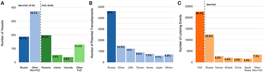
Figure 1. Flag state patterns. (A) top flag states transshipment vessels, identifying nearly 43% flying Flags of Convenience (FoC), (B) top flag states of fishing vessels involved in encounters, illustrating that nearly 45% of these events involved Russian fishing vessels, (C) Top flag states of cargo vessels involved in loitering events, illustrating the overrepresentation of Russian vessels (~19% of the transshipment vessels involved in ~27% of these events) and the prevalence of vessels flying FoCs.
This list likely includes the majority of the world's specialized transshipment vessels. Given the size of these vessels, and the fact that they often conduct international voyages, most transshipment vessels are required to carry AIS. Ninety-seven percent of the transshipment vessels in our dataset were larger than 300 gross tonnage (GT) and thus are mandated to carry AIS when on international voyages. Our total number (694 unique vessels) compares favorably with an estimate of refrigerated cargo vessels reported to be active in 2010 by the CIA World Fact Book (882 vessels, Central Intelligence Agency, 2013). Similarly, a search of the International Maritime Organization website for “Refrigerated Cargo Vessel” gives about 1,000 vessels that have been active since 1981, and many of these vessels have been decommissioned since then. Our dataset is likely missing smaller transshipment vessels that operate exclusively near shore (such as some fish tenders or smaller fish carriers), but these are likely to be vessels with limited capacity or vessels that do not make international voyages. Most likely, the vast majority of large, internationally traveling transshipment vessels are on our list. One notable exception is Japanese transshipment vessels. Of the 80 Japanese-flagged fish carriers listed as active on the WCPFC registry (WCPFC, 2018), only 26 appear in our data.
Single-Vessel Loitering and Two-Vessel Encounters
Flag State Distribution
We identified 10,233 encounters between fishing vessels (1,869 unique MMSI) and transshipment vessels (501 unique MMSI) from 2012 to 2017, with nearly half of the events (44.7%) involving Russian-flagged fishing vessels (Figure 1B). Encounters involving fishing vessels flagged to China, USA, and Taiwan were next most common. Between 2012 and 2017 we observed roughly four times more loitering transshipment vessel events (46,570) than encounters, involving 824 unique transshipment vessel MMSI. These events predominantly featured transshipment vessels flying flags of convenience, with Russian-flagged vessels representing the most common non-FoC (Figure 1C).
Spatial Distribution
The global footprint of encounters and loitering events is extensive (Figure 2). Over half of these events occur in the high seas beyond national jurisdictions (51.8%, Figure 3). Within the high seas, transshipment behaviors are common in the equatorial regions of the Pacific and Atlantic Oceans and in the southern Indian Ocean. There are also clear regional patterns of transshipment behaviors in international waters near the EEZs of Peru, Argentina, and Japan/Russia, regions known for large squid fleets. In international waters around the African continent, transshipment clusters at the edge of the East African EEZs. For events that occur within national jurisdictions, the majority (51.4%) occur within the Russian EEZ, with transshipment behavior also common within the EEZs of African nations (Figure 3).
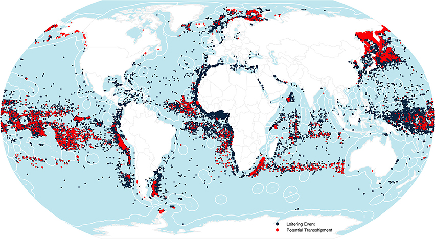
Figure 2. Global patterns of transshipment behavior illustrating encounters (red) and loitering events (black). Highest densities appear in the Russian Far East and the Barents Sea, outside the Exclusive Economic Zones (EEZs) of South America, within the EEZs of African nations, and across the Equatorial Pacific.
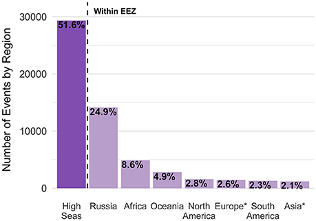
Figure 3. Geographic distribution of loitering events and encounters (combined). Roughly 52% of the events occur in the high seas. *Note that Russia is presented separately.
Flag Pairings
While Russia appears to play a disproportionate role in our dataset, 96% of the encounters involving a Russian-flagged fishing vessel were with a Russian-flagged transshipment vessel (Figure 4). Ninety-eight percent of the events involving a Russian fishing vessel occurred within the Russian EEZ. In fact, in 90% of the events within the EEZ, both vessels were Russian flagged. A similar pattern is seen for USA-flagged fishing vessels, which met USA-flagged transshipment vessels in 83% of encounters. In contrast, China, Taiwan, South Korea and Japan (the next most common fishing vessel flag states involved in encounters) associated with transshipment vessels flying an array of flags including several FoCs (Panama, Liberia, Vanuatu). For example, Panamanian-flagged transshipment vessels account for 79, 59, 40, and 81% of the encounters involving fishing vessels from China, Taiwan, South Korea and Japan, respectively.
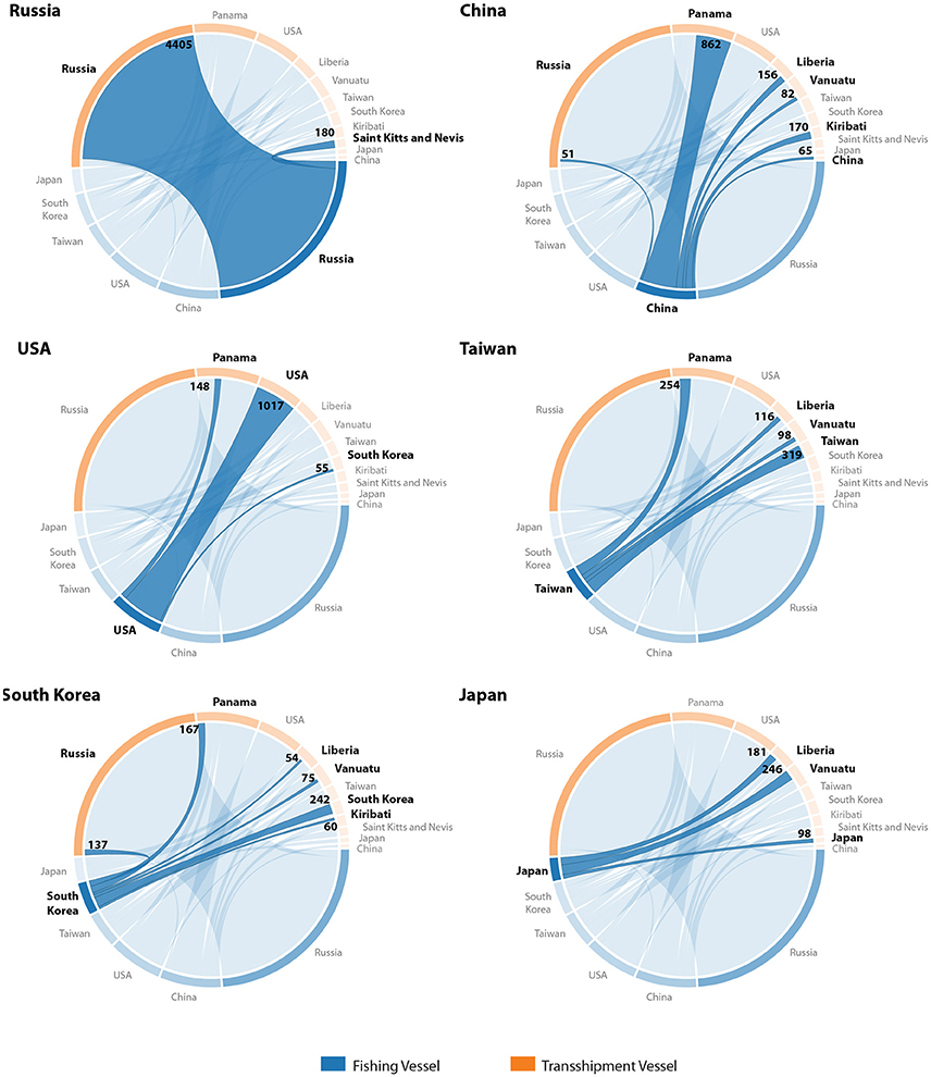
Figure 4. Flag pairings for fishing and transshipment vessels involved in encounters, for the fishing vessel flags with greatest number of encounters. Russian- and US-flagged fishing vessels predominantly associate with common-flagged transshipment vessels, whereas Asian-flagged fishing vessels associate with diversely flagged transshipment vessels. Values identify number of events involving each flag pair.
Fraction of Fishing
Between 2012 and 2017, 6,003 vessels fished for more than 24 h on the high seas, and 20% of those vessels (1,181) had at least one encounter with a transshipment vessel in the high seas at some point. This cohort of vessels accounted for a disproportionate share (43%) of the high seas fishing activity during that time period. It is unlikely this entire share of the high seas catch was transshipped, but it does show that a major fraction of fishing on the high seas is by vessels that meet up with transshipment vessels.
Sensitivity Analysis
To assess the influence of the parameters used to define loitering events and encounters we compared the percent change in total hours of loitering or encounters with a percent change in each parameter. We found that encounters were most sensitive to changes in minimum encounter duration from 6 to 10 and 10 to 12 h (Table 1, Figure S1), with 30.2 and 15.4% decreases in total encounter hours and response ratios of −0.46 and −0.77, respectively. Encounters and loitering were both sensitive to decreases in the maximum encounters speed from 2 to 1 knots, with a response ratio of 0.33 for encounters (Table 1) and 0.84 for loitering (Table 2, Figure S2). Both total encounters and total loitering hours were considerably less sensitive to other parameter changes (all response ratios < 0.3). This suggests that if transshipments occur at median speeds greater than 2 knots, our results are likely conservative. If transshipment events only occur at median speeds < 1 knot, (and do not occur at median speeds between 1 and 2 knots) we are likely overestimating the number of events and potentially by 15–20%. Given that our encounters algorithm incorporates short periods of maneuvering before and after the vessels are in close proximity, it would not be unusual to assign an encounter a median speed between 1 and 2 knots, even while the vessels traveled more slowly during the actual exchange of goods.
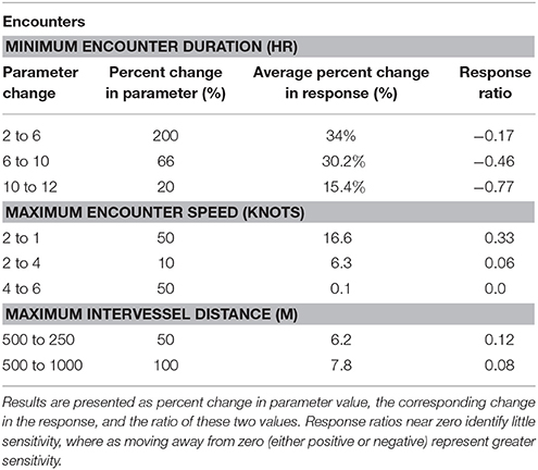
Table 1. Sensitivity analysis for encounters, identifying the sensitivity of total encounter hours to changes in three parameters (minimum encounter duration, maximum encounter speed, and maximum intervessel distance) used to detect encounters.
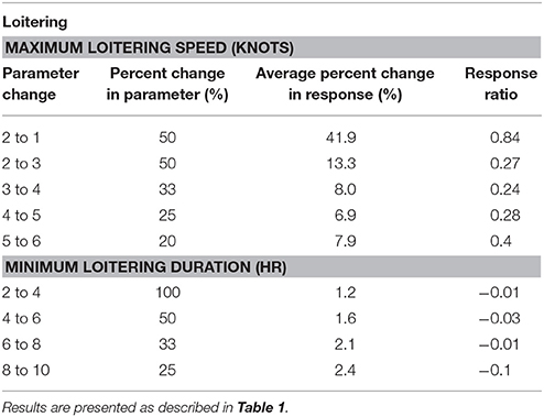
Table 2. Sensitivity analysis of loitering events, identifying the sensitivity of total loitering hours to changes in two parameters (maximum loitering speed and minimum loitering duration) used to detect loitering.
Discussion
Transshipment of catch at sea obscures supply chains, complicates sustainable management practices, and provides IUU operators access to reputable markets (Food Agriculture Organization of the United Nations, 2002). Transshipment also enables human rights abuses such as slavery, trafficking, bonded labor, emotional, and physical abuse (Environmental Justice Foundation, 2015; Greenpeace, 2016). Despite growing concerns regarding the sustainability of transshipment (Ewell et al., 2017), the fact that the activity typically occurs far from port, with varying degrees of observer coverage, and limited transparency from fisheries management agencies has prevented a coherent conversation. Here we utilize AIS vessel position data to provide a global view of potential transshipment, identifying the scale at which at-sea transshipment may be occurring, the primary participants, and the broad spatial patterns.
While AIS data provide a valuable transparency tool for identifying high seas transshipment activity, there are several important limitations. AIS use varies globally and among fleets, which may skew the fraction of encounters observed by fleet. For example, the WCPFC Record of Fishing Vessels lists 80 Japanese fish carriers; however, we have only identified MMSI for 26 of these vessels and only 5 engage in encounters. Our database of encounters likely underestimates actual transshipments both because of limits in AIS coverage as well as that fact that our transshipment vessel database is incomplete. On the other hand, the loitering events likely overestimate transshipments, as refrigerated cargo vessels may loiter at sea while waiting for their next job or to minimize time spent within dangerous regions. However, these events may bracket the true set of actual transshipments and in those regions where they exhibit spatial agreement bolster one another.
One major shortcoming is our inability to compare the loitering events and encounters events to accurate vessel-specific information about transshipment activity. Regional databases are not publically available, and the few that we obtained were either of low quality or incomplete in ways that prevented us from using them to train or test models. As a result, we are limited to reporting the number of events we see from our rules-based heuristics. Fortunately, we find that our results are relatively robust and change only modestly if we change the parameters (Tables 1, 2).
One of the most striking features of our analysis is the high density of transshipment behavior in the Russian Far East, the Sea of Okhotsk, and the Russian Barents Sea, which are known for their pollock and crab fisheries. Much of this activity likely represents standard modes of operation driven in part by the vast distances between the fishing grounds and the primary ports of Vladivostok and Murmansk. Nearly all (96%) of the events we identified involved Russian-flagged fishing vessels meeting Russian-flagged transshipment vessels, 90% of these meetings occurred within the Russian EEZ, and 46% involved Marine Stewardship Council (MSC) certified pollock fishing vessels within the Sea of Okhotsk (MSC certification F-ACO-0058/FCI-F-0040). Thus, while we are not able to determine legality, a large proportion of the events in this region are under Russian jurisdiction and some level of MSC scrutiny. For example, Russian regulations require that all vessels receiving catch within the Russian EEZ must report to a Russian port for customs declarations before traveling on to a foreign port. However, concern has been expressed that this requirement is not being met (Pramod et al., 2014). While the possibility remains, we found that following encounters within the Russian EEZ, transshipment vessels consistently entered a Russian port prior to continuing on to a foreign port, such as Busan, Korea.
A second striking feature of our analysis is the global scale of transshipment activities, which occur in all ocean basins and involve vessels responsible for 43% of the fishing within the high seas. While transshipment activity occurs at a global in scale, nearly 47% of encounters occur on the high seas, and a similar proportion are by transshipment vessels flying flags of convenience. Such findings raise transparency concerns as a large proportion of transshipments occur within waters beyond national jurisdiction, or are undertaken by vessels registered to countries with lax oversight and limited connection to the vessel.
Transshipment on the high seas appears largely associated with longline fisheries targeting migratory species, such as tunas, billfishes and sharks. Such fisheries are known for their utilization of transshipment, as it moves the catch to market quickly, while maximizing time on the fishing grounds (McCoy, 2012; Greenpeace, 2013). While transshipment activity involving highly migratory species is regulated by the relevant RFMO, there are transparency concerns as these events take place far from port and with varying levels of observer coverage, where even strict regulations may be difficult to enforce. With this in mind, the transshipment behaviors we've identified in the southern Atlantic are of interest as they occur within the SEAFO convention area, an RFMO that banned at-sea transshipments in 2006 (Ewell et al., 2017; SEAFO, 2017). While we cannot be certain if these encounters and loitering events represent the transshipment of catch, they raise the possibility of unregulated transshipment occurring in regions where transshipment is purportedly regulated. Within the high seas, transshipment of catch that is not under specific RFMO jurisdiction also represents a critical loophole. Also readily apparent in our data is a cluster of transshipment activity in the northwest Indian Ocean, a region recently reported to host a growing, unregulated fleet of Chinese squid vessels, a fleet whose fishing is made possible by transshipment with reefers flying FoCs (Stop Illegal Fishing et al., 2017).
Another pattern of transshipment activity is its regional prevalence just beyond EEZ boundaries, such as that seen near Peru and Argentina. In both cases the transshipment activity occurs within the high seas in the vicinity of productive squid fisheries. In the case of Peru the squid vessels are regulated by the South Pacific Regional Fisheries Management Organization (SPRFMO), but no such organization exists to manage the the high seas off Argentina. The congregation of transshipment activity near the EEZ boundary raises two transparency concerns. The first is simply that this activity is once again occurring within a vast region, which is potentially less well regulated than the neighboring national waters. The second concern is the proximity of the transshipment activity to the EEZ boundary. This could enable a “dark fleet” of vessels that are not broadcasting AIS to fish without authorization within the EEZ and then transship that catch to vessels outside the EEZ, thereby avoiding the need to make port calls with illegally caught fish.
By comparison, encounters and loitering events off western Africa occur well within the national waters, quite close to the coast. For much of western Africa the current regulatory and enforcement infrastructure is ineffective, with an estimated loss of 2.3 billion USD annually to IUU fishing and recovery of only 13 million USD through Monitoring, Control and Surveillance (Doumbouya et al., 2017). Consequently, transshipment, which maximizes profit and resource exploitation in the region, may be supporting fishing that reduces sustainability, harms local livelihoods, threatens food security and exposes communities to broader criminal activities (Environmental Justice Foundation, 2013; INTERPOL, 2014). Our results demonstrate that inasmuch as the encounters and loitering events represent transshipments, they are most prevalent in regions with less-effective fisheries management and enforcement (Melnychuk et al., 2016).
While incomplete, our data illustrate the prevalence and transnational nature of transshipment. We show that transshipment behavior clusters along EEZ boundaries in the high seas, is common in regions of challenging or limited regulation and oversight, and often involves vessels registered to flags of convenience. Given the potential association of transshipment with IUU fishing and other illicit exchanges (Phelps Bondaroff et al., 2015; Haenlein, 2017), these patterns of transshipment raise questions that could be addressed by increased transparency and information from RFMOs and other governing bodies. We are publishing our identified loitering events and encounters, along with vessel details, on http://globalfishingwatch.org/datasets-and-code/, to assist with comparing these data to official records. While more data and transparency are needed fully reveal the global patterns of transshipment, our data highlight the transnational challenge of transshipment at sea and make clear that effectively addressing the accompanying sustainability and human rights challenges of slavery, trafficking, and bonded labor will require a global perspective and international cooperation.
Author Contributions
NM, AR, and DK contributed to conception and design of the study and JA provided critical intellectual content. TH, AR, and NM developed the transshipment detection algorithms, TH implemented the algorithms as applied to AIS. NM, AR, and DK wrote sections of the manuscript. All authors contributed to manuscript revision, read and approved the submitted version.
Funding
We gratefully acknowledge the Walton Family Foundation for direct support of our transshipment research. We additionally thank Adessium Foundation, Bloomberg Philanthropies, Leonardo DiCaprio Foundation, Marisla Foundation, The Waterloo Foundation, and Wyss Foundation for supporting Global Fishing Watch which provided data and analyses critical to conducting the transshipment research. Google generously provided cloud computing resources and technical guidance.
Conflict of Interest Statement
The authors declare that the research was conducted in the absence of any commercial or financial relationships that could be construed as a potential conflict of interest.
Acknowledgments
P. Woods, E. Tuya, A. Arana, E. Mueller, and K. Wurster assisted with engineering for the AIS data pipeline. A. Wilson, C. Bacon, and K. Schwehr assisted with data processing, machine learning, and data labeling. K. Boerder, K. Seto, and B. Bergman provided valuable insights into regional transshipment activities. We also wish to thank SkyTruth, Oceana and Google as Founding Partners of Global Fishing Watch. Our global AIS dataset is provided by ORBCOMM and Spire Global Inc.
Supplementary Material
The Supplementary Material for this article can be found online at: https://www.frontiersin.org/articles/10.3389/fmars.2018.00240/full#supplementary-material
References
CCAMLR (2011). Conservation Measure 10-09, Notification system for transshipments within the Convention Area. Available online at: https://www.ccamlr.org/en/measure-10-09-2011
CCAMLR (2016). Conservation Measure 10-05, Catch documentation scheme for Dissostichus spp. Available online at: https://www.ccamlr.org/en/measure-10-05-2016
Daniels, A., Gutierrez, M., Fanjul, G., Guerena, A., Matheson, I., and Watkins, K. (2016). Western Africa's Missing Fish. The Impacts of Illegal, Unreported and Unregulated Fishing and Under-Reporting Catches by Foreign Fleets. Overseas Development Institute. Available online at: https://www.odi.org/sites/odi.org.uk/files/resource-documents/10665.pdf
Doumbouya, A., Camara, O.T., Mamie, J., Intchama, J.F., Jarra, A., Ceesay, S., et al. (2017). Assessing the effectiveness of monitoring control and surveillance of illegal fishing: the case of West Africa. Front. Mar. Sci. 4:50. doi: 10.3389/fmars.2017.00050
Environmental Justice Foundation (2013). Transshipment at Sea. The Need for a Ban in West Africa. pp 1–7. Available online at: https://ejfoundation.org/reports/transhipment-at-sea-briefing
Environmental Justice Foundation (2015). Pirates and Slaves: How Overfishing in Thailand Fuels Human Trafficking and the Plunder of Our Oceans. pp 1- 40. Available online at: https://Ejfoundation.Org/Resources/Downloads/EJF_Pirates_And_Slaves_2015_0.Pdf
Ewell, C., Cullis-Suzuki, S., Ediger, M., Hocevar, J., Miller, D., and Jacquet, J. (2017). Potential ecological and social benefits of a moratorium on transshipment on the high seas. Mar. Policy 81, 293–300. doi: 10.1016/j.marpol.2017.04.004
Food and Agriculture Organization of the United Nations, FAO. (2002). Implementation of the International Plan of Action to Deter, Prevent and Eliminate Illegal, Unreported, and Unregulated Fishing. FAO Technical Guidelines for Responsible Fisheries No. 9. pp.1–141.
Food and Agriculture Organization of the United Nations, FAO. (2016). The State of World Fisheries and Aquaculture. Contributing to Food Security and Nutrition for all. Rome. 200 pp.
FFA (2016). The Harmonized Minimum Terms and Conditions for Foreign Vessel Access. Conservation Measure Amended by FFC99. Available online at: https://www.ffa.int/system/files/HMTC%20FFC99%20V4July2016.pdf
Greenpeace (2013). Out of Line: The Failure of the Global Tuna Longline Fisheries. Available online at: https://www.greenpeace.org/archive-international/Global/international/publications/oceans/2013/459-OutOfLineReport-DEF-LR.pdf
Greenpeace (2016). Turning the Tide. Human Rights Abuses and Illegal Fishing in Thailand's Overseas Fishing Industry. Available online at: http://www.greenpeace.org/seasia/PageFiles/745330/Turn-The-Tide.pdf
Haenlein, C. (2017). Below the surface: How illegal, Unreported and Unregulated Fishing Threatens Our Security. Occasional Paper, Royal United Services Institute.
IMO (2002) Safety of Life at Sea Conventions (SOLAS) Title 33, Code of Federal Regulations, Section164.46 Automatic Identification System (AIS). (amended 07/01/03).
INTERPOL (2014). Study on fisheries Crime in the West African Coastal Region. Environmental Security Sub-Directorate. Available online at: https://www.interpol.int/content/download/27590/369574/version/3/file/WACS%20EN.pdf
International Telecommunication Union (ITU) (2014). Technical Characteristics for an Automatic Identification System Using Time Division Multiple Access in the VHF Maritime Mobile Frequency Band. Recommendation ITU-R M.1371-5. Available online at: www.itu.int/dms_pubrec/itu-r/rec/m/R-REC-M.1371-5-201402-I!!PDF-E.pdf
Kroodsma, D. A., Mayorga, J., Hochberg, T., Miller, N.A., Boerder, K., Ferretti, F., et al. (2018). Tracking the global footprint of fisheries. Science 359, 904–908. doi: 10.1126/science.aao5646
McCauley, D. J., Woods, P., Sullivan, B., Bergman, B., Jablonicky, C., Roan, A., et al. (2016). Ending hide and seek at sea. Science 351, 1148–1150. doi: 10.1126/science.aad5686
McCoy, M. (2012). A Survey of Tuna Transshipment in Pacific Island Countries: Opportunities for Increasing Benefits and Improving Monitoring. Forum Fisheries Agency, Honiara.
McDowell, R., Mason, M., and Mendoza, M. (2015). AP Investigation: Slaves May Have Caught the Fish You Bought. Available online at: https://www.ap.org/explore/seafood-from-slaves/ap-investigation-slaves-may-have-caught-the-fish-you-bought.html
Melnychuk, M. C., Peterson, E., Elliot, M., and Hilborn, R. (2016). Fisheries management impacts on target species status. Proc. Nat. Acad. Sci. U.S.A. 114, 178–183. doi: 10.1073/pnas.1609915114
Phelps Bondaroff, T. D., van der Werf, W., and Reitano, T. (2015). “The illegal fishing and organized crime nexus: Illegal fishing as transnational organized crime,” in Global Initiative Against Transnational Organized Crime and The Black Fish (Geneva), 1–83.
Pramod, G., Nakamura, K., Pitcher, T. J., and Delagram, L. (2014). Estimates of illegal and unreported fish in seafood imports to the USA. Mar. Policy 48, 102–113. doi: 10.1016/j.marpol.2014.03.019
Schwehr, K. (2015). C++ Decoder for Automatic Identification System for Tracking Ships and Decoding Maritime Information, Version 0.15. Available online at: https://github.com/schwehr/libais
SEAFO (2017). System of Observation, Inspection, Compliance, and Enforcement. Available online at: http://www.seafo.org/media/9396af91-f45a-42a0-b296-623edca01ac4/SEAFOweb/pdf/System/SEAFO%20SYSTEM%202017_pdf
Stop Illegal Fishing, Trygg Mat Tracking, NFDS. (2017). Squid Capture in the Northwest Indian Ocean: Unregulated Fishing on the High Seas. Gaborone. Available online at: https://www.fish-i-africa.org/wp-content/uploads/2017/06/Squid_capture_in_the_NWIO_FINAL_LR.pdf
UNDOC (2016). Fisheries Crime. Transnational Organized Criminal Activities in the Context of the Fisheries Sector. Available online at: https://www.unodc.org/documents/about-unodc/Campaigns/Fisheries/focus_sheet_PRINT.pdf
WCPFC (2009). Conservation and Management Measure on the Regulation of Transshipment. Conservation and Management Measure 2009-06.
WCPFC (2018). Western and Central Pacific Fisheries Commission Record of Fishing Vessels. Available online at: https://www.wcpfc.int/record-fishing-vessel-database
Keywords: fisheries, transshipment, refrigerated cargo vessel, IUU fishing, reefer
Citation: Miller NA, Roan A, Hochberg T, Amos J and Kroodsma DA (2018) Identifying Global Patterns of Transshipment Behavior. Front. Mar. Sci. 5:240. doi: 10.3389/fmars.2018.00240
Received: 31 March 2018; Accepted: 25 June 2018;
Published: 23 July 2018.
Edited by:
Dyhia Belhabib, University of British Columbia, CanadaReviewed by:
Brett W. Molony, Department of Primary Industries and Regional Development of Western Australia (DPIRD), AustraliaSimon Foale, James Cook University, Australia
Copyright © 2018 Miller, Roan, Hochberg, Amos and Kroodsma. This is an open-access article distributed under the terms of the Creative Commons Attribution License (CC BY). The use, distribution or reproduction in other forums is permitted, provided the original author(s) and the copyright owner(s) are credited and that the original publication in this journal is cited, in accordance with accepted academic practice. No use, distribution or reproduction is permitted which does not comply with these terms.
*Correspondence: Nathan A. Miller, bmF0ZUBza3l0cnV0aC5vcmc=