Abstract
Monitoring the long-term human expansions in coastal zones and evaluating their associated environmental impacts are critical to promoting a sustainable transformation of a society. This paper evaluated the long-term human expansion of reclamation, aquaculture ponds (saltern) and artificial surface in the Circum-Bohai Coastal Zone (CBCZ) of China based on the Google Earth Engine (GEE) platform and time-series land use (LU) function classification, and analyzed the impact of human expansion on the sustainability of coastal environment. Results show: (i) human activities in this coastal zone have expanded dramatically during the past 30 years, including an increase of 1555.50 km2 (+76.9%) for the reclamation area, 2065.53 km2 (+51.33%) for the aquaculture pond area, and 14329.99 km2 (+308%) for the artificial surface area; (ii) there are substantial spatial and temporal variations in human expansion in this coastal zone, mainly for Bohai Bay, Laizhou Bay, and Liaoning Bay, with the most intense expansion in the period 2003-2013, (iii) the spatial and temporal evolution of human activity expansion is strongly related to changes of water environmental quality and wetland loss, with the coupling degree of 70.73% and 79.41%, respectively. The expansion of human activity has led to a considerable loss of wetland number (from 2666.54 km2 to 1698.27 km2), indirectly affecting changes in offshore water quality. We found that human expansion is mostly driven by economic interests such as port construction, industrial parks, resource development, and tourism development, as well as a direct response to coastal zone development and protection policies.
Introduction
Coastal zones host over 70% of the world’s large cities and populations (Tu et al., 2022), with intensifying human expansion in terms of rapid urbanization and increasing economic activities (Halpern et al., 2019; Zou et al., 2019; Jouffray et al., 2020). These human expansions have imposed great ecological pressure on coastal zones, such as ecosystem function degradation, biodiversity loss, affecting local ecosystem resilience (Mentaschi et al., 2018; Goldberg et al., 2020). Take the Bohai Sea as an example. From 2000 to 2015, the total value of ecosystem services decreased by 3.80%, from 581.06 billion yuan to 558.97 billion yuan (Liu et al., 2020). In addition, combined with the data from the Statistical Bulletin of Marine Environment, the proportion of Class IV and inferior Class IV seawater in the coastal waters of the Bohai Sea increased from 19.2% to 29.03% from 2005 to 2015. Therefore, monitoring human expansion in the coastal zone and evaluating the associated environmental impacts is a crucial way to promote sustainable transformation.
As the continuous growth in human demand for seafood and the rapid development of new industries and ports adjacent to the sea, human expansion is mainly represented as reclamation, increase of aquaculture, and rapid expansion of coastal artificial surface (Wu et al., 2018; Ren et al., 2018; Sengupta et al., 2018). Human expansion has inevitably caused serious impacts on local and neighboring sea ecosystems, triggering a series of negative effects such as water pollution, habitat degradation, and reduction of species diversity (Dou et al., 2013; Murray et al., 2014; Murray et al., 2015; Finnegan et al., 2015; Blowes et al., 2019). The total reclamation area in China was up to 11,162.89 km² between 1979 and 2014. The reclamation hotspots include Bohai Bay, the coast of Jiangsu Province, and Hangzhou Bay (Meng et al., 2017). The formation of port terminals, industrial parks, and tourism facilities can lead to a conversion of a large number of natural shorelines into hardened artificial shorelines, leading to profound changes in the hydrodynamic environment such as tides and waves, and a weakening of the water exchange and pollutant transport capacity of the bay (Gao et al., 2014; Nazeer et al., 2020). Also, pollutant discharges such as domestic sewage and industrial wastewater from highly populated regions and industrial activities further deteriorated the coastal environment (Maanan et al., 2015; Flo et al., 2019). In addition, the expansion of constructed surfaces and aquaculture ponds has been threatening wetlands, mudflats, and intertidal zones, and causing habitat fragmentation. The loss of many fish spawning grounds and migratory birds significantly affects the ecosystem functions of the coastal zone (Jiang et al., 2015; Li et al., 2018; Murray et al., 2022). Some studies have shown that construction, such as port terminals, could increase the vulnerability of coastal zones to sea level rise and increase ecological risk of coastal zones (Wu et al., 2016; Zhai et al., 2020). In human intensive coastal areas such as ports and urban areas, the level of microplastics in soil and shellfish is significantly higher than that in other coastal areas (Li et al., 2016). Human expansion has degraded the ecosystem of the coastal zone as well as diminishing the various ecosystem services (Wang et al., 2021).
Limited by the spatial and temporal resolution of remote sensing data and the processing capacity of the platform, it was difficult to detect changes and long-term patterns in human expansion in the coastal zone (Kuenzer et al., 2011; Schneider, 2012; Gallant, 2015). As the open applications of remote sensing big data platforms such as Google Earth Engine (GEE), monitoring human expansion in the coastal zone using GEE has become a current hot issue and has made breakthroughs. Methodologically, these studies can be classified into three groups. The first group is to construct long-term time-series remote sensing ecological indices, such as Normalized Difference Water Index (NDWI) (Xie et al., 2016; Ezzine et al., 2017), Normalized Difference Built-Up Index (NDBI) (Ranagalage et al., 2017), Modified Normalized Difference Water Index (MNDWI) (Ghosh et al., 2015; Du et al., 2016), etc. These indices can achieve the identification of human activities such as aquaculture (Ottinger et al., 2016; Zhang et al., 2019), artificialized net pens (Fu et al., 2021), land reclamation (Wang et al., 2017; Hua et al., 2017), and drilling platforms (Dong et al., 2022). Second, the full element classification and mapping for change detection of human expansion such as construction land and reclamation using long-term time series Landsat images (Tian et al., 2016; Jia et al., 2018). Third, a multi-source image fusion approach is used to input densely stacked (dense stacking) time series data to the classifier to directly classify and extract change information, which has been shown to significantly improve the accuracy of change detection (Yi et al., 2018). Moreover, the material exchange and physical processes occurring in land-sea environmental processes are extremely complex. Long-term time-series data allow an accurate evaluation of the negative impacts of human expansion (Santos et al., 2016; Xu et al., 2021). Available studies have shown that there is an urgent need to enrich studies that analyze the spatial and temporal variation regarding the evolution of coastal human activity from a long time series perspective and reveal the ecological feedback induced in the process (Benway et al., 2019).
The objective of this study is to explore the impact of human expansion on the environmental sustainability of coastal zone. This objective can be resolved into three key questions: First, how to evaluate long-term human expansion in the coastal zone? Second, how to characterize the changes of environmental sustainability of coastal zone? Third, how to quantify and analyze the spatial and temporal correlations between them? Thus, the paper takes Circum-Bohai Coastal Zone of China as study area, and uses the GEE platform and long-term time series multi-source data to achieve a long-term land use classification from 1990 to 2020. Based on the classification results, we integrated and analyzed the temporal and spatial variation of the long-term sequence human expansion in the coastal zone from three aspects: reclamation (loss of natural seawater caused by human activities), aquaculture pond (saltern) (shallow artificial water bodies with distinctly), and artificial surface (construction land formed by human activities). Next, we select the long-term time series of water environmental quality and coastal wetland loss to characterize the environmental sustainability of coastal zone, and analyze the changes of them during the same period. Finally, we analyze the spatial and temporal correlations between human expansion and environmental sustainability of coastal zone, and verify and analyze the impact of different types of human expansion on the environmental sustainability of coastal zone with the investigations of sample areas and coastal zone policies.
Study area
The Bohai Sea is China’s only semi-enclosed inland sea and also one of the 11 typical semi-enclosed seas in the world. It consists of the main seas and Liaodong Bay, Bohai Bay, and Laizhou Bay (Figure 1), along which more than one hundred rivers are flowing into the sea, including the Yellow River, the Hai River, the Liao River, and the Luan River, which forms three major basins: the Hai River, the Yellow River, and the Liao River. The sand load of the flowing rivers makes the Bohai Sea become a shallow basin on the continental shelf, with gentle topography, wide mudflats and an annual siltation area of 20 square kilometers. The wide delta wetlands of the Liaohe estuary, the Yellow River estuary, and the Haihe estuary are inhabited by more than 150 species of birds and other rare animals and are important ecological shelter in northern China.
Figure 1
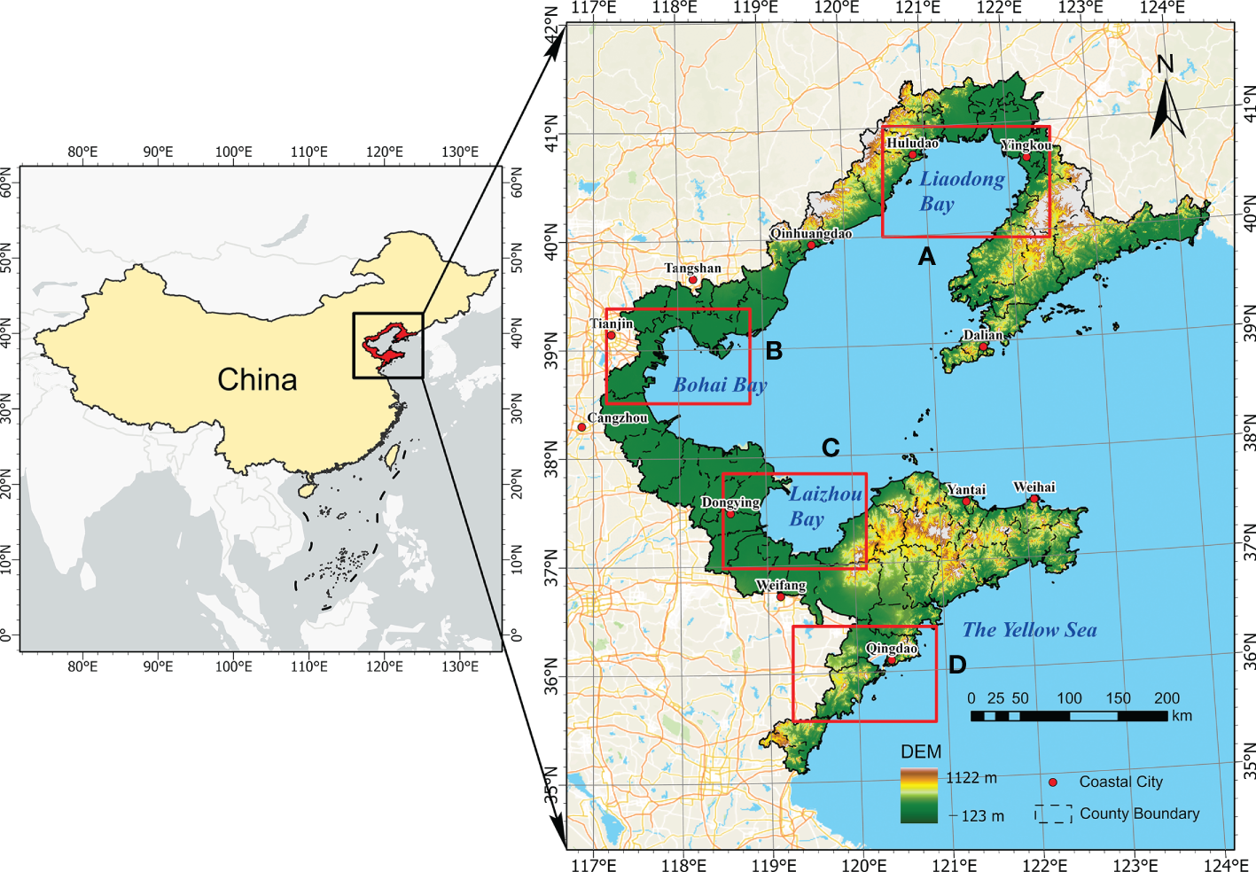
Overview map of the study area. The panel on the left shows the location of the study area, and the right shows the bay areas and important port cities included. Red boxes and labels on the right indicate the spatial extents of regional examples shown in Figure 3.
The CBCZ involves 17 coastal cities in Liaoning, Hebei, Shandong, and Tianjin, and its resident population grew from 77.17 million to 91.07 million between 2000 and 2020, an increase of 18%, accommodating nearly 6.5% of the population within 2% of the country’s land. Moreover, the Bohai Sea coastal zone has been occupying an important position in the national marine economy. Since the reform and opening up, most cities on the Bohai Sea have been dominated by intensive industries. The offshore oil field in the Bohai Sea, as well as the Shengli oil field, Dagang oil field, and Liaohe oil field in Bohai Bay, constitute the second largest crude oil production area in China. Most coastal zones are low-lying plains, involving the North China Plain, the Yellow and Huaihai Sea Plain, and the Liao River Plain, which are covered with a large amount of arable land and serve as an important barn for China. The shallow water area of estuaries is rich in nutrient salts and has many bait organisms. The deep-water area in the middle of the Bohai Sea is both a staging area for economic fish, shrimp, and crab migration in the Yellow and Bohai Seas, and an overwintering ground for local fish, shrimp, and crabs in the Bohai Sea. It is evidently a large marine aquaculture base in China. Besides, it is the largest salt farming base in China due to its suitable climate.
With the launch of the national ocean strategy and the “Belt and Road” strategy, authorities at all levels in the CBCZ are still playing the banner of “ocean economy” and “blue land”, ignoring the constraints of coastal natural environmental conditions on development intensity, spatial structure, and development mode. These authorities also ignored the reasonable coordination of various resources and the spatial configuration of production and living in the coastal zone, and were unceasingly enthusiastic about the blind large-scale development of the coastal zone. These would potentially cause great damage to the sustainability of coastal zone by the failure of coastal zone development strategies and policies, such as continuous water quality pollution in land and offshore waters, massive loss of coastal wetlands and biodiversity damages, etc.
Methods
We obtained the long-term time-series LU classification images in the coastal zone on the GEE platform using the RF algorithm and separated seawater and aquaculture ponds (including salt fields) using the optimization method of spatial morphology and temporal change logic. Based on the classification results, the space-time variation of the long-term human expansion in the coastal zone is integrated and analyzed from three perspectives: reclamation, aquaculture ponds, and artificial surface. Human expansion is coupled with long-time-series offshore water quality and ecological degradation processes to reveal its resulting environmental effects. Combined with the field research in the study area and a review of the evolution of the main coastal zone policies, we verified and analyzed the impact of human expansion types and coastal zone development and protection policies on the coastal environment. The diagram of the technical process is shown in Figure 2.
Figure 2
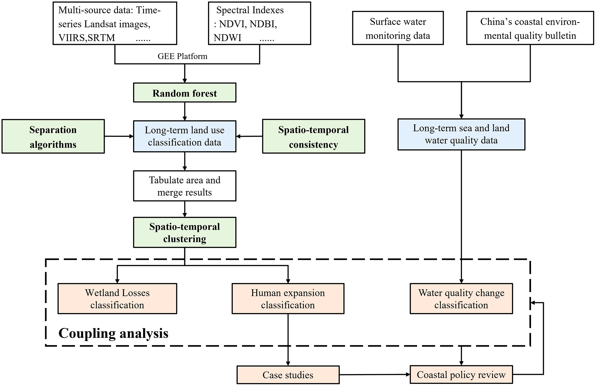
An integrative schematic of this study, including acquisition of core datasets (blue), processing of land use classification (green), and subsequent suggestive analysis (orange), which aimed to characterize the relationship between human expansion and environmental sustainability.
Data
The data used in this study includes the historical image data of the Landsat series on the GEE platform, including the Landsat Thematic Mapper (TM), Enhanced Thematic Mapper Plus (ETM+), and Operational Land Imager (OLI). We used the GEE platform to screen the available Landsat data in the Bohai Sea region during 1990–2020. The screening conditions include (1) obtaining data for two periods, June to October (lush vegetation period) and November to March (vegetation withering period), and (2) less than 10% cloudiness. We also selected several spectral indices to enhance the identification of features, such as the NDVI, NDWI, etc. (Jiang et al., 2014; Zhou et al., 2017). Moreover, we made use of some additional data to assist the classification, such as Visible Infrared Imaging Radiometer (VIIRS) night light data, Shuttle Radar Topography Mission (SRTM) digital elevation data, and some climate monitoring data. The VIIRS night light data is from its nighttime day/night band (DNB) dataset, and we used the monthly averaged images to distinguish the urban area from others. The SRTM data is from the U.S. Land Distributed Activity Archive Center and has been interpolated using open-source data (ASTER GDEM2, GMTED 2010, and NED). The climate monitoring data include precipitation, temperature, and accumulated temperature from Famine Early Warning Systems Network (FEWS NET) Land Data Assimilation System (FLDAS). To conduct cross-validation and to obtain prior knowledge, we used Point of Interest (POI) data and land cover products from the Resource and Environment Science and Data Center, Chinese Academy of Sciences. The water quality data consists of fluvial and coastal quality data. The former comes from monitoring sensors managed by the department of ecology and environment, which is classified into 5 levels from I to V, according to “Environmental quality standards for surface water” (GB3838-2002). The latter is from “China’s near-shore sea area environmental quality bulletin”. Combining with vector data of county boundary, we obtained long-time-series county-scale offshore water quality data.
Long-term LU classification of coastal zone based on the GEE platform
Based on the GEE platform, we used the RF algorithm to initially classify the long-time-series LU products, and then adopted the scan line seed fill algorithm and geometric feature analysis to separate seawater and aquaculture ponds (saltern). Then, the LU types involved in the transformation of arable land, aquaculture ponds, and reclamation are corrected based on the logical rules of space-time changes. The main process is listed as follows:
-
(1) Initial LU classification. We selected sample points of different LU types each year within the period based on high-resolution historical images and field research. We conducted 10-20 times random position distribution on the training sample points on the GEE and took the result with the highest accuracy as the final training sample. Then, we computed spectral indices including NDWI, NDVI, and normalized difference building index (NDBI), and introduced the VIIRS nighttime light data, SRTM digital elevation data, and all texture features from the raw Landsat images that can be calculated by GEE to form combinations of different feature variables. Accuracies of different combinations were compared to get the optimal feature vector. The RF classifier was trained with the selected training samples and the optimal feature variable combination. After the training, the raw images were classified year by year.
-
(2) Separation of seawater and aquaculture ponds. We adopted the scan line seed fill algorithm (Yu et al., 2010) to separate seawater from all water bodies, which can be described as ① selecting a seawater pixel as a seed point and putting it into the stack as the object to be filled; ② filling the section from the horizontal scanning line where the current seed point is located to the land boundary; ③ deleting the seed point in the stack after filling, and determining the upper and lower parallel scanning lines adjacent to the seed point, and ④ storing the points adjacent to the seed point in the stack as the seed point to be filled next time in the section between the two parallel scanning lines and the boundary. This process was repeated until all seed points in the stack were cleared. After that, preprocessing object segmentation and contour extraction were performed on the inland water body, and three morphological features of the ith inland water object Pi were calculated in sequence: the centerline length Li, the aspect ratio Ri and the convex hull Convi. The aspect ratio Ri is the ratio of the centerline length Li of the inland water object Pi to the total number of pixels Si of the inland water object Pi, and the convex hull Convi is the ratio of the convex perimeter Pi (c) to the perimeter Pi (P) (Chen et al., 2022), which can evaluate the convexity of the object. If Li> 30, Ri > 0.2, and Convi< 0.45 are established, then the inland water object Pi was determined as a natural water body, otherwise, it was classified into an aquaculture pond.
-
(3) Spatio-temporal consistency correction. We sorted each LU type time series on the pixel level and marked it with a unique key, which corresponds to different sequence types. The sliding window WM and the seed window WS of the space-time records were constructed then. The initial position of the sliding window WM was located immediately outside the corresponding seed window S, and the time consistency correction was performed on the long-term LU classification data in the study area. Taking pixel-level time series as a processing unit, we used the 3*3 sliding window and adopted a mode filtering method to correct the classification data in the center of the window integrally, and applied this method to all pixels. The detailed process can be described as:
-
① Constructing two seed windows WS and two sliding detection windows WM, respectively, for the time series stored by each key. The initial positions of the two seed windows WS were located at the beginning and end of the time series, and the sliding time window step size N was set. N is a natural number greater than 3;
-
② Placing the sliding window WM inside the seed window WS;
-
③ Calculating the dominant functional LU type FM within the sliding window WM;
-
④ Determining whether the feature type FS in the seed window WS is consistent with the dominant functional ground type FM in the adjacent sliding detection window WM. If so, set all the ground types between the leading and trailing dominant ground type grids in the sliding window WM as FS, and move the seed window position to the grid position where the dominant ground type FS finally appears in the sliding window. Go to step ② until the first or last year of the time period, and process all the records stored in the hash table; If it is inconsistent, move the seed window inward by one bit, go to step ② until the first or last year of the time sequence, and process all the spatiotemporal cubes stored in the hash table.
Spatio-temporal change detection of human expansion in the coastal zone
Based on the LU classification products, we extracted the areas of reclamation, aquaculture ponds, and artificial surface in each county unit by tabulating areas. The reclamation area was defined as the reduction of seawater coverage, and the artificial surface area was the total amount of the urban land area, rural land area, and other artificial surface area in the LU classification data. We aggregated the results of the corresponding counties by year, thus obtaining the time series of human expansion area in all of them.
A clustering algorithm Partitioning Around Medoid (PAM) was adopted in this study to mine the spatial disparity pattern behind the long time-series LU classification data. The PAM algorithm is an implementation of K-Medoids clustering, which uses the medoid point existing in the cluster as the center of the cluster, whose sum of distances to all other points in the cluster is minimal. It is more robust to noise and outliers and is commonly used in the field of time series clustering, and can show the similar LU pattern spatially based on the similarity of time series. We chose the Euclidean distance to measure the similarity of time series, which is one of the most common distance measures for clustering time series of equal length and one-to-one mapping. Let denote a time series of length n, the distance dist (i, j) between it and another series can be described as the sum of the distances between all corresponding points, which is:
We uniformly set the cluster numbers as 5 under different circumstances, which can not only clearly and comprehensively show the spatial and temporal evolution pattern of the study area, but also help to unify the understanding framework. A higher cluster level represents a more intense human expansion. To comprehensively characterize the extent of human expansion, we adopted the weighting method and combined it with expert knowledge to give different weights to the areas of reclamation, aquaculture ponds, and artificial surface, and summarized the comprehensive index of human expansion. Among them, the higher the value of the index, the more significant human expansion.
Analysis of environmental effects in the coastal zone
The wetland loss and water quality in the coastal zone were selected as the main indicators of environmental effect analysis. Among them, the wetland loss data mainly comes from the classification results of land use functions in section 3.1, which is expressed as the area of natural land (forest land, grassland, unused land, natural water body, tidal flat, and seawater) within the buffer zone 2km from the coastal boundary of the administrative division to the land that has been transformed into production and living land (cultivated land, aquaculture ponds, and artificial land). We divided the buffer zone according to the boundaries of the counties, counted the wetland area in the buffer zone included in each unit, and clustered the natural land area in each unit in the time series concerning section 3.2.
The offshore water quality data includes the monitoring data of the main river sections in land areas and offshore sea areas. According to the water quality standards, it is divided into six grades, I, II, III, IV, V, and inferior V. The smaller the grade, the better the water quality. Due to the different time availability of land and offshore water quality data, we adopted a qualitative evaluation standard to uniformly classify the water quality grades of each county into the following five categories: ① continuously good, class I or class II exist in all time nodes only, and the number of class II does not exceed 20% of the entire time range, with no significant change trend in the time series of water quality; ② improved, the water quality series has an upward trend significantly; ③ fluctuating, the water quality in different years has a difference of more than or equal to one grade, which includes at least three consecutive time nodes, and there is no trend in the time series; ④ degrading, the water quality series has a downward trend significantly; ⑤continuously poor, class II or above exist in all time nodes, and there is no significant change trend.
In order to explore the relationship between human expansion and wetland loss and water quality change in the coastal zone, we connected different analysis results in space to further calculate the corresponding relationship between indicators. We counted the frequency of each data pair and calculated their coupling degree. It is noted that some inland counties which do not border the coastline buffer zone were not included in the calculation when exploring the relationship between the human expansion and the loss of wetlands.
Results
The Long-term human expansion in coastal zone
The human expansion on the Bohai coast is reflected in three aspects: reclamation, aquaculture ponds, and artificial surface expansion. In the past three decades, the land reclamation along the CBCZ has reached 1555.5km2, and the top three target reclamation land use types are artificial surface (772.64km2, 49.67%), aquaculture ponds (570.11km2, 36.65%), and cropland (103.29km2, 6.64%). As can be seen from the four typical examples (Figures 3A-D), the reclamation is concentrated in the port areas, such as the Tianjin Port and Caofeidian Port in Bohai Bay, the Weifang Port in Laizhou Bay, the Jinzhou Port, Yingkou Port, and Dalian Port in Liaodong Bay, etc. Around these ports, there are large areas of new land formed by reclaiming land from the sea. The period 2003-2014 was the most severe period of reclamation expansion along the CBCZ, in which the average annual growth rate of reclamation reached 165.5 km2 (Figure 4A). From 2015 to 2018, the phenomenon of reclamation in the CBCZ eased. However, in 2019 and 2020, the reclamation area showed an increasing trend. From 1990 to 2020, the total area of expanded aquaculture ponds in the coastal zone were 2065.5km2, with a planar or punctate manner (Figure 4B). The expansion of aquaculture ponds has been clustering in the three major bay areas (Figures 3e–g), whereas in Qingdao, the expanded aquaculture ponds were generally scattered and dotted, except for the local regions of Jiaozhou Bay (Figure 3h). Timewise, the area of aquaculture ponds in the CBCZ has fluctuated greatly in the past three decades. During the three time periods (or nodes) of 1995-2001, 2006-2009, and 2015, the total amount of aquaculture pond area has been on the rise. In the first growth stage, the expansion of aquaculture ponds was the most obvious, with an area of 2389.4 km2. The growth areas of the following two time periods (nodes) were 997.3 km2 and 693.8 km2 respectively. However, in 2002-2005, 2010-2013, and 2014-2019, the pond area decreased, and the reduced part reached 950.1 km2, 644.1 km2, and 830.3 km2, respectively. The purple line in Figure 4B represents the newly increased pond areas (i.e., only consider the situation that other LU types convert to aquaculture ponds), and it can be found that though the newly increased pond areas were higher than that in other years, the total area may still decline. Compared with the fluctuating situations in the previous two types, the artificial surface has maintained an upward trend in the past three decades (Figure 4C). From 1990 to 2020, the expanded artificial surface area around the CBCZ was 14626.9 km2. It can be seen that the expanded artificial surface was mainly distributed along the coastline, and more concentrated in important ports like Qingdao port, Yantai port, Tianjin port and Tangshan port. Besides, a spreading trend from the coast to the inland was visible in the artificial surface expansion, which generally occurred later than that of aquaculture ponds (Figures 3i–l). Although the artificial surface area along the CBCZ increased from 1990 to 2003, the amplification was not large. From 2004 to 2020, the expansion rate of artificial ground increased significantly, and the average annual growth rate increased from 206.8 km2/y to 693 km2/y. Figure 5 shows the county-level time series clustering results based on the human expansion in the CBCZ in the past 30 years. Figure 5A shows the clustering result of reclamation (corresponding to the reduction of seawater), and the reclamation expansion of class 5 and class 4 counties are the most intense. These two classes of counties correspond to the important ports in several bay areas around the Bohai Sea. The former includes Binhai New Area and Caofeidian District of Tianjin port, and the latter corresponds to Wafangdian City of Dalian port. The area of reclamation area in class 5 has expanded rapidly since 2003, while in class 4 the expansion lagged by one year. In contrast, the reclamation area in class 3 and class 2 also expanded, but the increase rate was less than that of class 5 and class 4. Figure 5B shows the clustering result of aquaculture ponds. Class 4 with an obvious upward trend in the ponds area is mainly distributed in the south of Bohai Bay, such as Wudi County, Zhanhua District, and Hekou District. However, the areas of the remaining four types either fluctuated or maintained in a small number. Among them, class 5 corresponding to Binhai New Area and Caofeidian District showed a trend of increasing first and decreasing then, and the total area of aquaculture ponds remained at a high level. Figure 5C shows the clustering result of the artificial surface. As mentioned above, the artificial surface area along the CBCZ was continuously increasing from 1990 to 2020. Among them, Binhai New Area, Huangye City, and Caofeidian District in Bohai Bay, Dongying City, Yantai City, Weifang City, and other coastal counties in Shandong Province had the most obvious growth. The mean area of the artificial surface in the cluster increased from 106.43km2 in 1987 to 724.28km2 in 2020. In addition, the artificial surface of the Qingdao port area has also increased significantly. In general, the CBCZ has seen a huge growth in the extent of reclamation and artificial land, particularly after 2003. While the area of aquaculture ponds has been fluctuating, only a few districts and counties showed significant growth. Figure 5D shows the expansion intensity of human activities. It can be seen that the human expansion along the CBCZ is mainly concentrated in Bohai Bay, Laizhou Bay, and the two important port cities of Dalian and Qingdao. Especially in the Binhai New Area, Caofeidian District, Huanghua City, Hekou District, Hanting District, Kenli district, and Wafangdian City, the expansion intensity of human activities are significantly higher than other districts and counties.
Figure 3
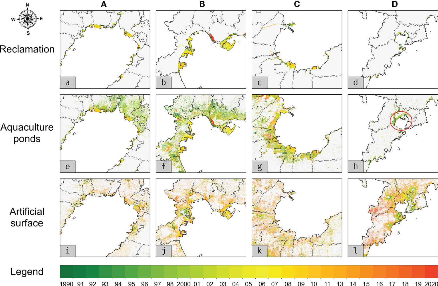
Human expansion across the Circum-Bohai Coastal Zone during the period 1990 to 2020. (a-d), Reclamation. (e-h), Aquaculture pond. (i-l), Artificial surface. The four example areas are: (A), The northern part of Liaodong Bay. (B), The northwestern part of Bohai Bay. (C), The southern side of Laizhou Bay. (D), The southern part of Qingdao city. The colors represent the year when the new LU type appear, and the extent of these examples are marked as red boxes in Figure 1.
Figure 4
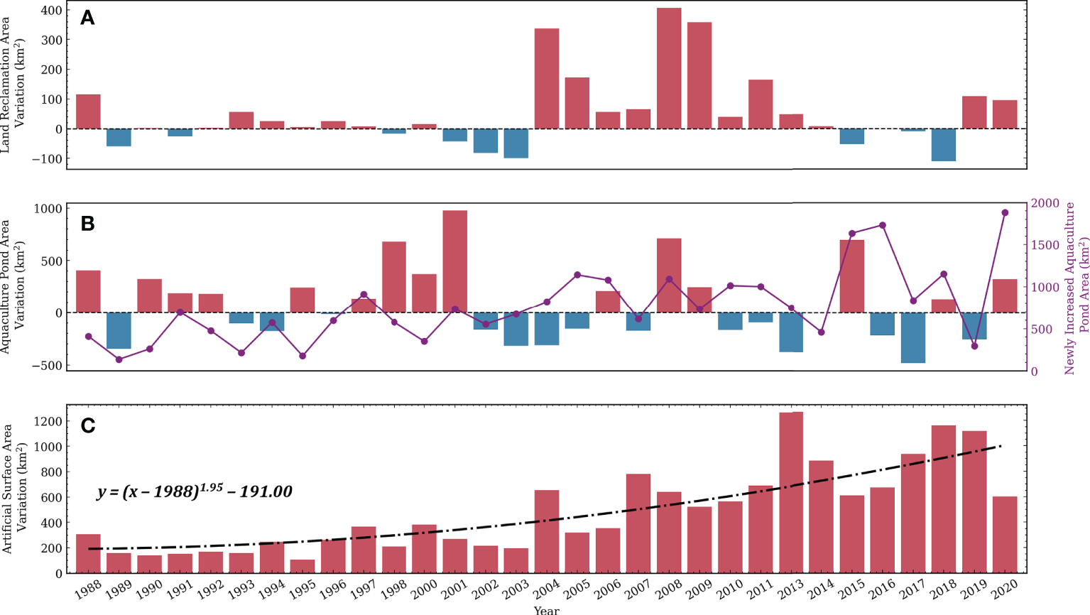
Analysis on the area changes of (A) reclamation, (B) aquaculture ponds, and (C) artificial surface in the Circum-Bohai Coastal Zone from 1990 to 2020.
Figure 5
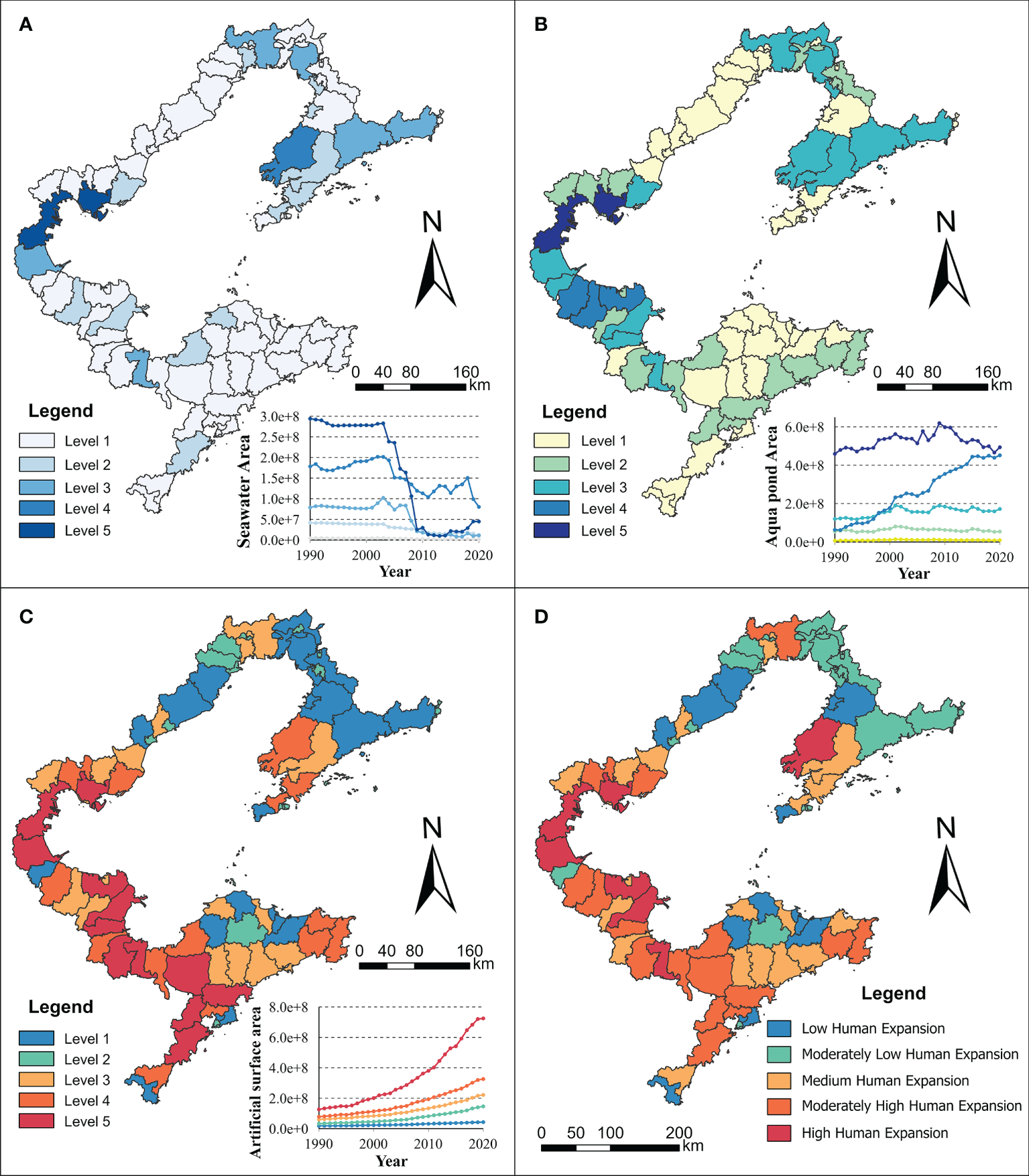
Time series clustering results of human expansion in the Circum-Bohai Coastal Zone: (A) reclamation, (B) aquaculture ponds, (C) artificial surface, (D) composite expansion index.
Environmental changes in the coastal zone
We analyzed the ecological change evolution of the CBCZ coastal zone from wetland loss and water environmental quality. Figure 6A shows the overall loss of wetlands around the CBCZ. As can be seen from the panel, the total wetland area in the buffer zone has been fluctuating since 2000, with no significant decline. During the period 2000 to 2003, the wetland area around the Bohai Sea was restored. However, the wetland area has entered a serious degradation stage since 2003, and it has decreased by 1287.3km2 from 2004 to 2014. Although the wetland ecosystem has recovered slightly in the following years, it is still far from its peak. It can be seen that the evolution of wetlands is significantly influenced by policy regulation. After the Regulation on the Prevention and Control of Pollution from Coastal Construction Projects in 1990 and Opinions on the Implementation of the Marine Ecological Red Line System in the Bohai Sea in 2012, the wetland ecology has been restored to some extent. However, the regulatory impact of the policy also has a certain lag, and it often takes two or three years to see obvious results. According to the clustering results, the areas with the most serious wetland degradation are Binhai New Area, Caofeidian District in Bohai Bay and Wafangdian City, Jinzhou district, and Zhuanghe City in Dalian city (class 5). The changing trend in this area is consistent with the overall trend. It has been in a rapid decline stage since 2003. From 2008 to 2014, there was a fluctuating change, afterwards, the wetland area gradually recovered. Figure 6B shows the combination of water quality changes. Overall, the water environment along the CBCZ is rather poor. There are 14 districts (17.1%) with serious water pollution and a worsening trend, and 43 districts and counties have extremely unstable water quality. There are different degrees of water pollution in Bohai Bay, Liaodong Bay, and Laizhou Bay, among which Weifang Port in Laizhou Bay and Jinzhou Port in Liaodong Bay are the most serious. The water environment of Shouguang City and Hanting district in Weifang port, Linghai city of Jinzhou port, and the nearby Pingdu City and Shuangtaizi District has been seriously polluted in the past 30 years. In addition, the water quality of 9 districts and counties, including Zhaoyuan City, Qixia City, Kenli District, Lijin County, and Dawa district, is continuously deteriorating. Although the water quality of Bohai Bay has not been seriously polluted or deteriorated, the water environment of most districts and counties was fluctuating, such as Binhai New Area and Huanghua City. Once the discharge of pollutants from human activities along the coast exceeds the threshold, this unsteady state will break and the water quality will deteriorate rapidly. As the only semi-enclosed sea in China, the environmental problems of the Bohai Sea are characterized by large inertia, high hysteresis, and strong outburst, which also bring great challenges to water quality management. Along the coast of the Bohai Sea, there are 49 seagoing rivers, such as the Haihe River, Daliao River, Daling River, and Luanhe River. The pollutants carried by these rivers remain in the offshore water for a long time. In addition, a large number of highly polluting industries, such as papermaking, coking, and electroplating, are distributed in Tangshan, Qinhuangdao, and Cangzhou, which further aggravates the water pollution in the Bohai Sea. In contrast, as Weihai, Yantai, Qingdao, and other cities are located on the east side of the Bohai Sea where the sea is open, they have strong water exchange capacity and self-purification capacity, so the water environment quality is better than that of the inner Bohai Sea. And the water quality of several districts and counties in Weihai is gradually improving.
Figure 6
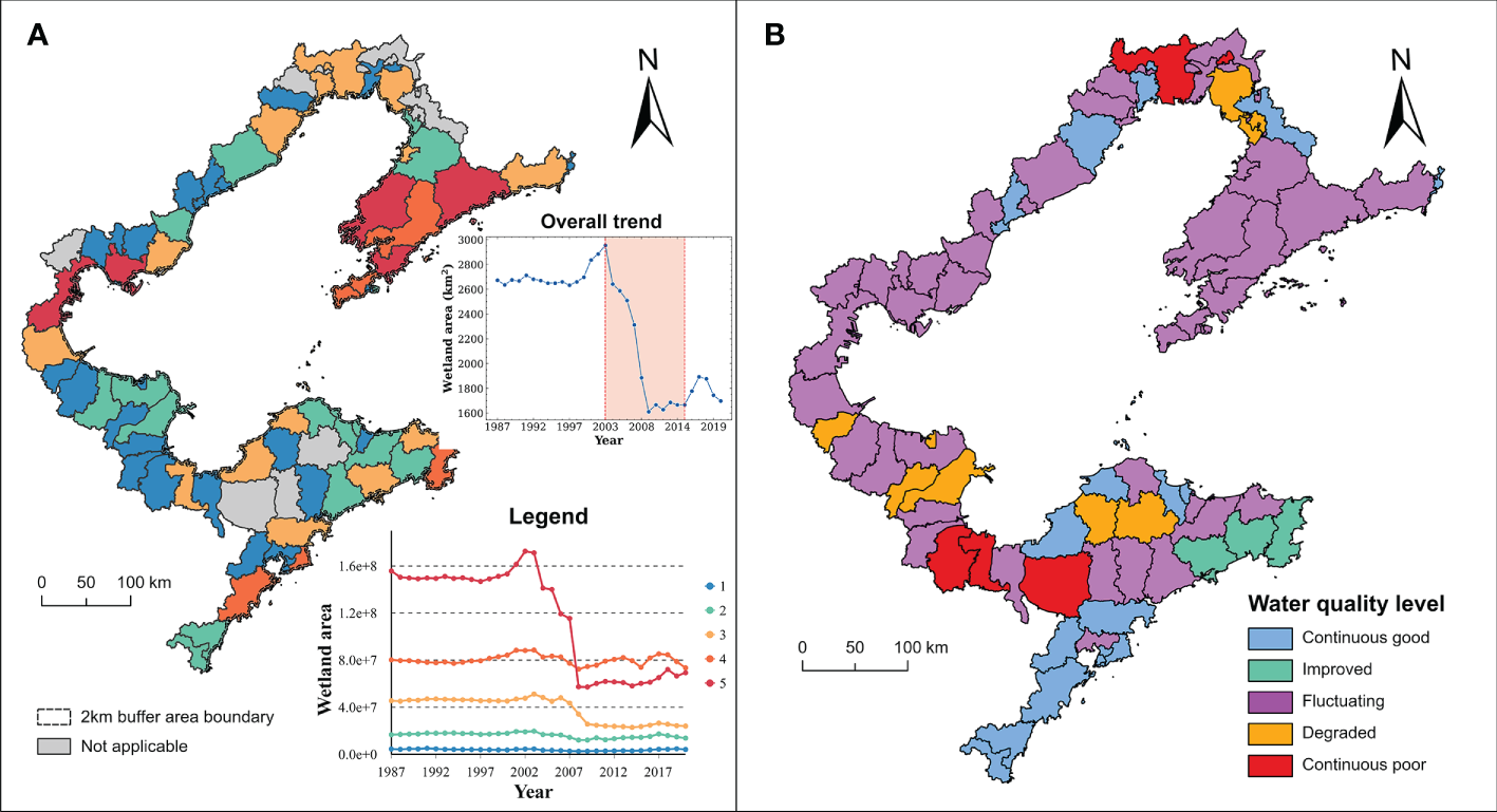
(A) Time series clustering results in wetland loss within the 2km buffer zone, the color of the buffer zone in each county is mapped to the whole region. The panel shows the overall trend of wetland area in the whole buffer zone; (B) the comprehensive land and seawater quality level.
Combining Figure 5, 6, it can be seen that there is a high coupling degree between environmental changes and human expansion intensity in the CBCZ spatially and temporally. Firstly, the period of the most severe degradation of coastal wetlands overlaps with the expansion of artificial surfaces and reclamation. Secondly, the areas with more serious wetland degradation and water pollution, such as Binhai New Area, Caofeidian District, and Hanting District, also have larger expansion levels for the three types of human activities. Figure 7 is a heatmap showing the correlation between human expansion and environmental change in the CBCZ. The value of each bin represents the frequency of two variable pairs. As can be seen from Figure 7A, except that the 1st stage of wetland loss corresponds to several levels of human expansion, the remaining scenarios are mainly distributed along diagonals and adjacent units. The number of the first level was large, indicating that although the comprehensive expansion degree of some districts and counties was relatively high, the development intensity in the coastal buffer zone was not necessarily as intense as that in the inland urban area. Based on the rule that the difference between the two indexes is not more than 1 and that the wetland loss is not lower than the human expansion over level 3, it can be calculated that there is a 79.41% coupling between the human expansion and the wetland loss. Figure 7B shows the relationship between the comprehensive index of human expansion and the water quality rank. The water quality of most districts and counties in Qingdao and Rizhao, which are located on the east side of the Bohai Sea, has remained at a good level (Level 1). On the one hand, it is due to the strong exchange and self-purification capacity of the water body in this area, and on the other hand, it shows that the water environmental quality can be taken into account while expanding the human surface in this area. Considering that water quality level 3 (severe fluctuation of water quality) has a large proportion in all levels of human expansion, it can be concluded that the coupling degree between the two factors has reached 70.73% based on the rule that the difference between the two indexes is not more than 1 and the human expansion index corresponding to water quality level 3 is not limited. In a word, it can be found that human expansion is closely related to ecological benefits spatially and quantitatively. Human expansion indirectly leads to changes in the offshore water environment and promotes the wetland loss.
Figure 7
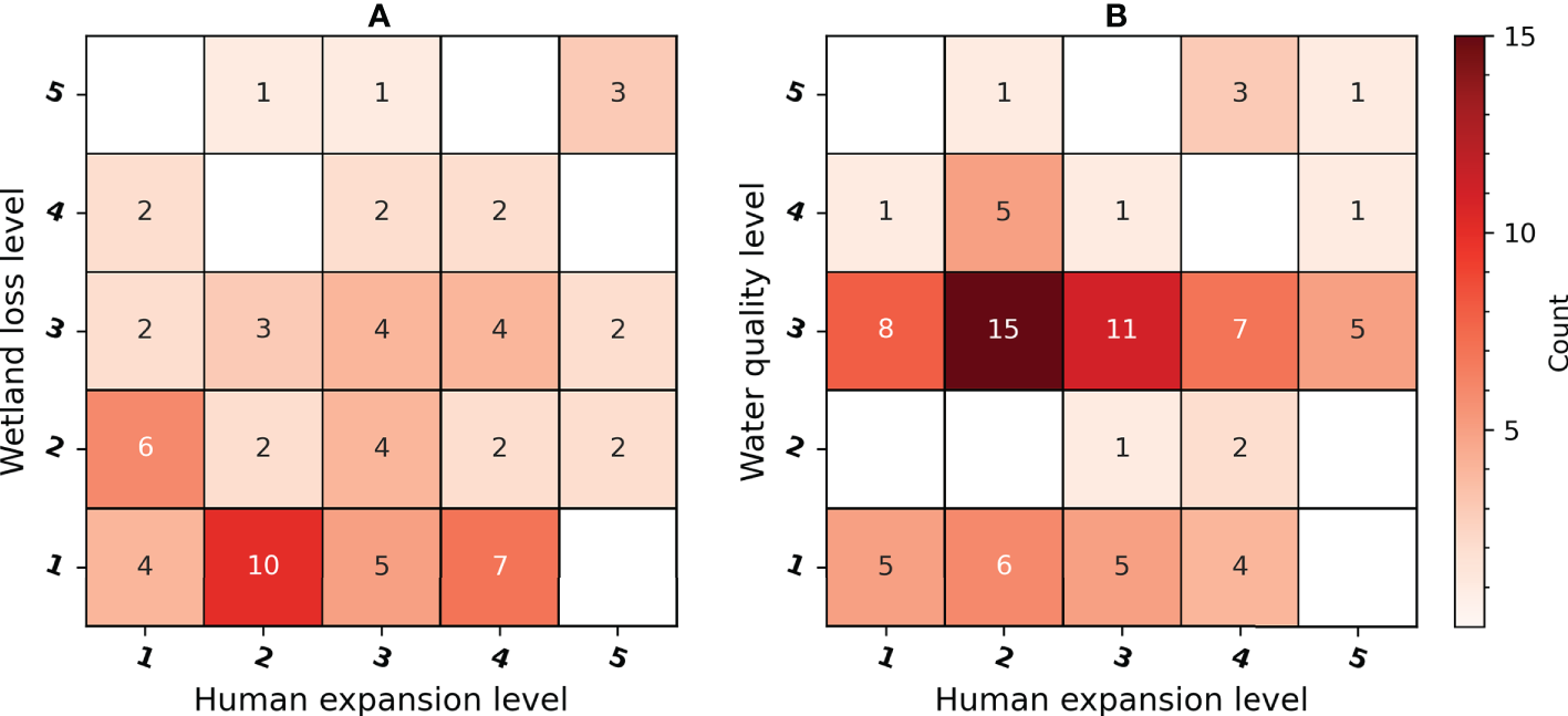
The correlation (frequency) heatmap between human expansion and environmental change: (A) wetland loss, (B) water environmental quality.
Discussion
As the transition zone between terrestrial and marine ecosystems, coastal zones have chronically been affected by the confluence of global climate change, regional environmental change, and human activities, of which human activities have increasingly become dominant (Hapke et al., 2013; Mentaschi et al., 2018). According to the sea level monitoring and analysis results released by the China Oceanic Administration, the rate of sea level rise in the Bohai Sea is 3.6 mm/year from 1980 to 2020, which is 0.2 mm/year higher than the average level of China’s coast. The long-term cumulative effect of sea level rise will, logically, directly cause loss of mudflats and ecological damage, and lead to storm surges, coastal urban flooding, and saltwater intrusion. In contrast to natural factors, changes induced by human activities interfering with coastal zones are often irreversible. Given the inherent enclosed nature of the Bohai Sea and its weak self-purification ability, the pollutant discharge from marine and coastal development activities and the degradation of natural ecosystems on land and sea are gradually increasing the stress on coastal zones. Combining the POI data, long-term remote sensing images, and field samples in CBCZ, and from the existing related works, we analyzed the representative human activities in coastal zones, such as town expansion, industrial parks, port construction, tourism development, mariculture, coastal engineering, resource extraction, and restoration works, to discuss their environmental impacts on coastal zones.
The impact of urban expansion on coastal zones mostly comes from its occupation of coastal wetlands and mudflats and the environmental pollution caused by various types of residential and commercial land use. In Tangshan, Dalian, and Yingkou on the Bohai coast, substantial amounts of arable land and mudflats have been converted into residential, commercial, and other building sites (Figure 8A). Millions of migratory birds and amphibians have lost their habitat due to the loss of coastal wetland mudflats (Yan et al., 2017; Xie et al., 2018; Murray et al., 2019; Ma et al., 2019). The domestic sewage from new residential land often contains large amounts of microplastics that are difficult to degrade, which also poses a great threat to the marine environment and marine animals (Zhou et al., 2018; Zhu et al., 2021). Reclamation is the main pathway for four types of human activities: port construction, tourism development, industrial parks, and coastal engineering. For example, there are a large number of port terminals and harbor industrial parks formed by reclamation along the coastline of Cangzhou City from Qikou to Dakouhekou (Figure 8B), and the artificial tourist island built next to the golden coast of Nan Daihe (Figure 8C), etc. Although reclamation can alleviate the problem of land constraints in the coastal zone, it also has a negative impact on the coastal ecosystem. The artificial shoreline of reclamation (Figure 8F) will change the hydro-dynamic environment, exacerbate the erosion and wetland degradation in the coastal zone, as well as destroy the living environment of marine fish (Jin et al., 2016; Xu et al., 2016; Zhang and Niu, 2021). Similarly, human activities such as port terminal operations and industrial zone development (Figure 8E) have increased the discharge of coastal pollutants, and long-term reclamation will weaken the water exchange and pollutant transport capacity of the bays, further exacerbating the pollution of offshore waters. (Zhang et al., 2017; Xu et al., 2021). While some coastal tourism projects in the region have boosted local economic development, many hidden dangers have been sown. For instance, the number of tourists in those tourist attractions exceeds the environmental capacity limit, and the massive tourists’ influx has increased the pollution of the local environment (Sánchez-Quiles and Tovar-Sánchez, 2015; Williams et al., 2016); some tourist attractions are disorderly and over-developed, which have greatly occupied the wetlands and affected the surrounding marine protected areas (Gil et al., 2015).
Figure 8
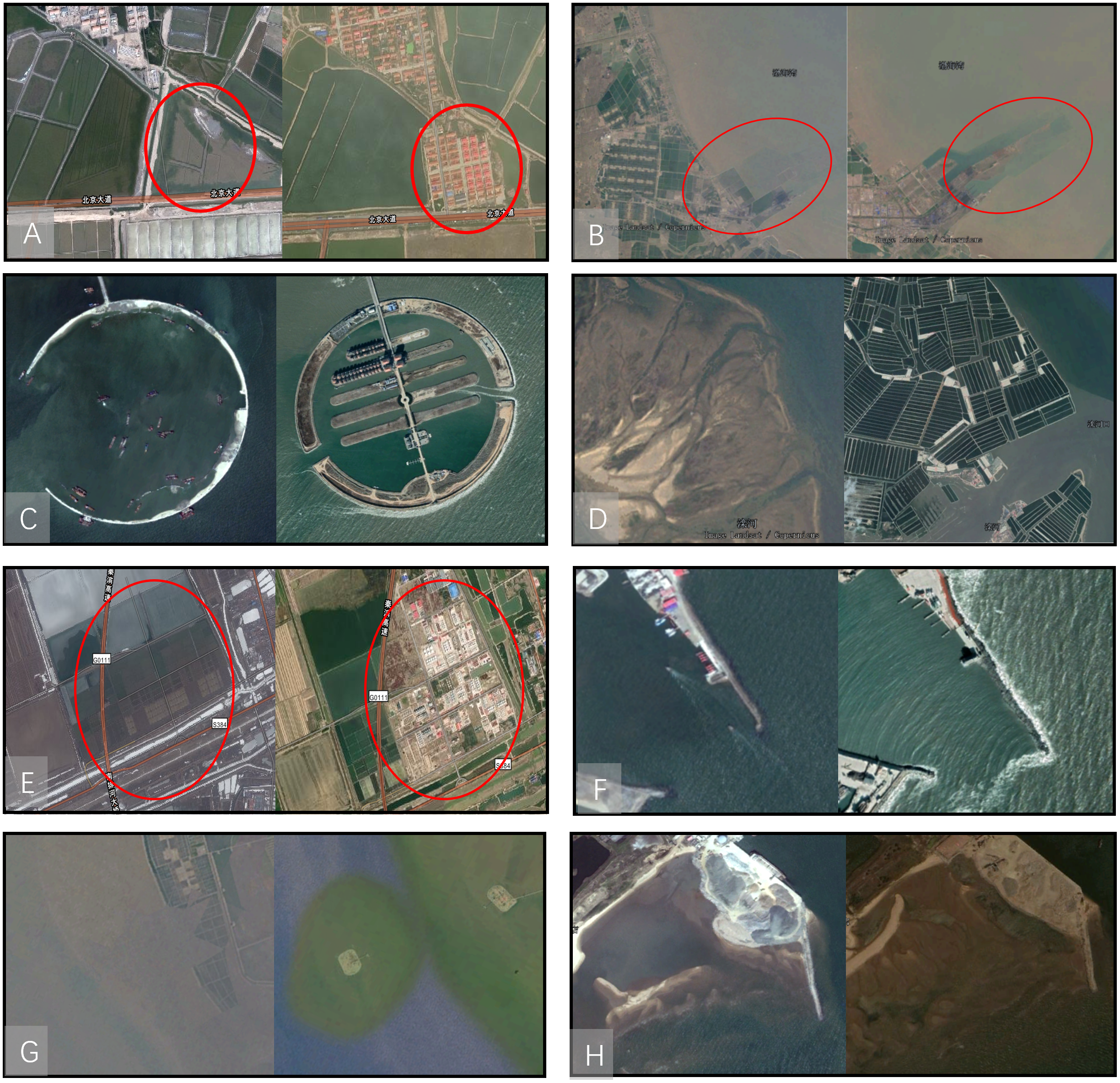
Typical types of human expansion in the coastal zone. (A) urban expansion in Tangshan, (B) port construction in Huanghua, (C) tourism development in Nandaihe, (D) mariculture in Luanhe River estuary, (E) industrial parks in Qinhuangdao, (F) coastal engineering in Qinhuangdao, (G) resource exploitation in Caofeidian, (H) repair engineering in Nandaihe.
China has become the world’s largest country in terms of mariculture area and production and mariculture is a common human activity in CBCZ. Figure 8D shows a substantial number of aquaculture ponds enclosed in a tidal flat wetland to the north of the entrance to the Luan River. The nutrients and chemicals put into mariculture will aggravate the eutrophication and heavy metal pollution of offshore waters (Zhang et al., 2012; Le Moal et al., 2019). Since coastal areas are rich in mineral and energy resources, such as alluvium, rare earth, oil, tidal energy, etc., the development of these resources is among the important human activities in coastal areas, such as the artificial island built by CNPC for oil extraction along the coast of Caofeidian District (Figure 8G). Various pollution dangers often associated with the process of resource extraction, such as oil spills from offshore drilling rigs and oil pollution from ruptured pipelines, all threaten the marine ecosystem. Encouragingly, not all human activities have a negative impact on the coastal area ecosystem. In recent years, with the emergence of environmental problems in the coastal zone and the increasing awareness of ecological civilization, many coastal provinces have carried out a series of ecological restoration efforts (Sun et al., 2015; Jia et al., 2018). Figure 8H shows the comparison of before and after the restoration of the mudflats around the Nandai River. In remote sensing images of Qinhuangdao, Yingkou, Zhoushan, and many other places, significant amounts of mudflat wetland restoration can be seen. Since 2010, when the Bohai Sea Rim region launched an ecological restoration campaign, 61 ecological restoration projects have been implemented in various provinces and cities. About 8,800 hectares of wetlands have been restored by the end of 2020, and about 130 kilometers of damaged shoreline have been repaired.
We also analyzed the relationship between the scale of reclamation and regional social economy, finding that the scale of reclamation was positive correlated with the average annual growth rate of resident population and gross domestic product (GDP), especially since 2003 the country encouraged marine economy. We found that the period 2003-2014, with the most reclamation, also has the highest average annual GDP growth rate, over twice as high as the period 2015-2020. The region’s GDP growth rate during this period exceeded the national average by about 20% as well. The population agglomeration shows the same characteristics. When it comes to water quality, it is found that the overall water quality of the study area deteriorated severely since 2008, which is later than the start of the most severe reclamation period 2003-2014. During 2008-2013, the water quality of the northern part of Bohai Bay and the western side of Liaodong Bay deteriorated greatly, which is in line with the reclamation in these regions. As for Laizhou Bay, its water quality remained good until 2011, which is slightly later than the other two bay areas. However, its reclamation land started intensive expanding since 2007, when the water quality remained well. During the period 2014-2016, the water quality of the entire study area has been improved, when the land reclamation area was basically unchanged, indicating that the water quality improvement and the decreased reclamation intensity were relevant. After 2017, the western Liaodong Bay’s water quality deteriorated again, but its reclamation intensity remained low level. Therefore, it is said that the reclamation scale and the water quality are relevant on the whole, but there exist different or asynchronous patterns in local regions.
As shown in the previous analysis, impervious surface growth, mariculture and reclamation as the main factors affecting the ecosystem of the CBCZ (Ren et al., 2018; Sengupta et al., 2018; Wu et al., 2018). These dynamics of human activity over time, however, are influenced to some extent by policies and institutions as well (Fan et al., 2018). When analyzing the changes in offshore water quality, it can be found that if the water quality was heavily polluted in the previous year, the water quality generally improved in the second year. Although the water environmental quality data are affected by the monitoring point location, sampling time, and spatial analysis unit, which may cause some errors, the results of this study are relatively credible benefiting from the stability of time series data. Probably the reason is that the deterioration of water quality for some time will attract the attention of the government, which will conduct corresponding measures to improve the water environment and bring the water quality back to good condition in the following year. A few clues can probably be found in the policy’s overview (Figure 9). As early as 2001, marine environment pollution in the Bohai Sea had caused national attention. In the same year, the State Council approved and implemented “the Blue Sea Activity Plan of Bohai”. However, since the governance of the CBCZ involves many provinces and departments, it is difficult to form a unified governance situation, so the “Blue Sea Action” has not achieved the desired results. During the same period, the State Council issued the “National Marine Economic Development Plan Outline”, which enabled the economic development and human exploitation activities on the CBCZ to enter a stage of rapid growth, further increasing the difficulty of environmental governance. Subsequently, Tianjin Binhai New Area, Liaoning Coastal Economic Zone, and Shandong Peninsula Blue Economic Zone became national development strategies one after another, stimulating the development of marine industries and coastal zones in the Bohai Sea Rim. Obviously, with the rapid development of the coastal economy, many environmental problems have worsened continuously, such as the degradation of fishery resources, water pollution, and the sharp decrease of wetlands (Wu et al., 2016; Zhou et al., 2018; Liu et al., 2020). Based on the previous analysis, the annual average increment of reclamation from 2003 to 2014 reached 165.5 km2. This period (2003-2014) is also the period of the most severe degradation of Bohai coastal wetlands, with a reduction of 1287.3km2. In 2008, the state promulgated the “Master Plan for Environmental Protection in the Bohai Sea Rim”, which set the goal of reaching more than 90% compliance with major marine functional zones by 2020. Subsequently, the State Oceanic Administration issued the “Opinions on Implementing the Marine Ecological Red Line System in the Bohai Sea” in 2012, requiring those exploitation activities that damage the ecosystem of marine areas, such as land enclosure and reclamation, are strictly forbidden in the restricted development zones. Since the Opinions were issued, the expansion of reclamation along the CBCZ slowed down gradually within two years. In 2017, ten ministries and commissions, including the State Oceanic Administration and the National Development and Reform Commission, jointly issued the Nearshore Sea Pollution Prevention and Control Plan. Subsequently, the state issued the first coastline regulations – the Measures for the Protection and Utilization of Coastlines and the Measures for the Control and Control of Reclamation. It is emphasized once again that ecological protection of coastal zone should be put in the first place. In December 2018, the State issued a new round of the Bohai Sea Comprehensive Governance Struggle Action Plan, and since then the environment around the Bohai Sea has improved again. It can be presumed that all kinds of exploitation activities in the coastal zones derive from the direct benefits of economic growth, and when the pollution caused by human activities affects the economic benefits, enterprises will spontaneously participate in environmental protection and form a joint effort with the government (Jiang et al., 2015; Tu et al., 2022). That’s the reason why the environment in the CBCZ is always in a cycle of deterioration, improvement, and deterioration.
Figure 9
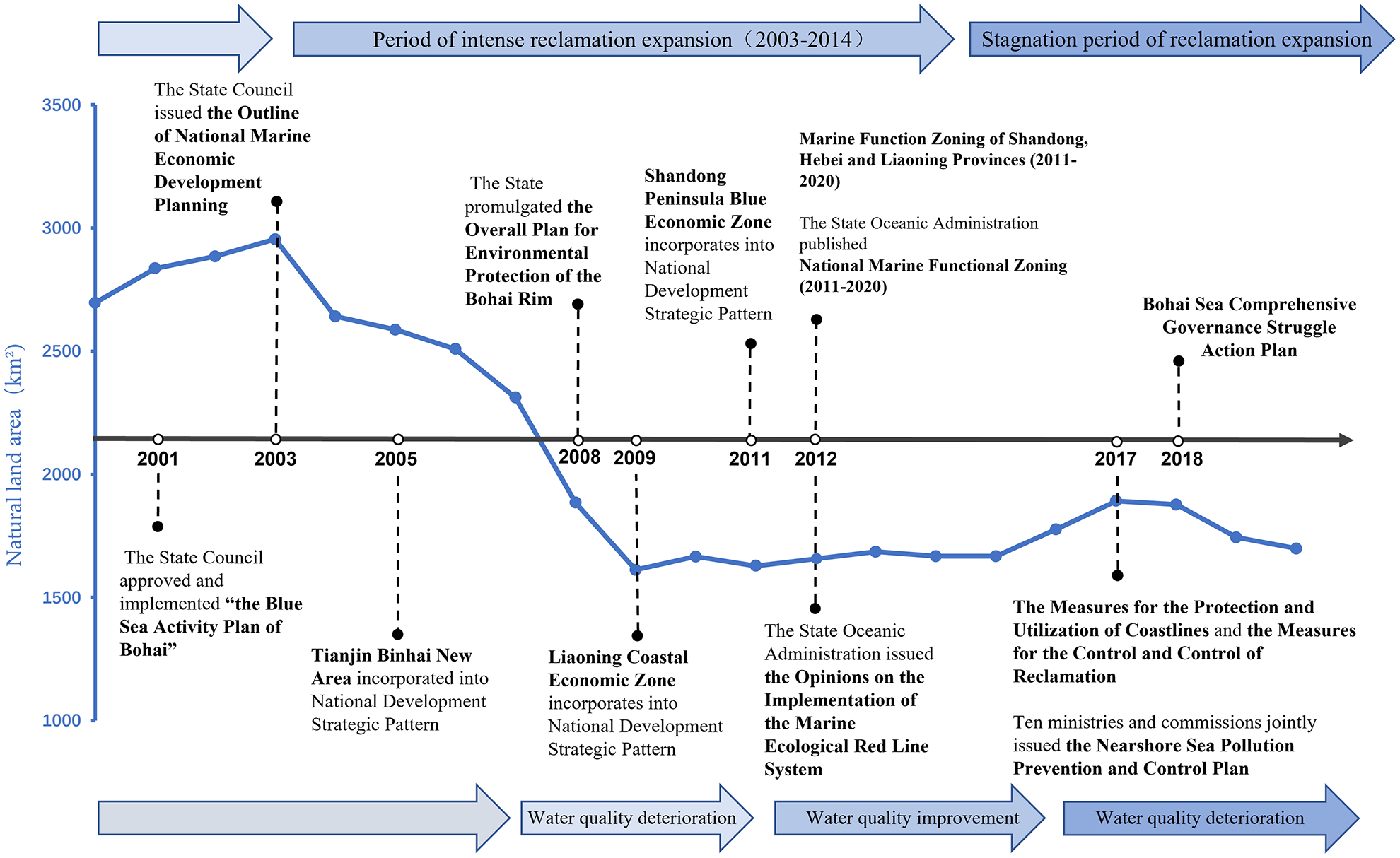
Development of coastal zone and changes in protection policies in the Circum-Bohai Coastal Zone.
Although the impact of natural changes such as sea level rise in the past 30 years is limited and incomparable with the impact of human expansion on the results of this paper. However, with further global changes in the future, the impact on the environmental sustainability of the coastal zone is expected to be increasingly significant. Accordingly, we recommend strengthening the long-term monitoring of climate change and human expansion such as reclamation in the coastal zone. In accordance with the conditions of the coastal zone’s resource and environmental carrying capacity, suitability for development, and importance of ecological protection, we should delineate the development boundary for human activities such as reclamation and ecological protection red line. We should strictly control the scale and intensity of reclamation and increase the difficulty and requirements for approval. For the completed reclamation projects, we should strengthen the monitoring of the surrounding water environmental quality and ecosystem, and improve the legislation and enforcement efforts. For the completed reclamation projects, we should strengthen the monitoring of the surrounding offshore water environment and ecosystem, and improve the legislation and enforcement efforts. In addition, it is desirable for governments at all levels to establish a coordination mechanism that integrates sea and land and crosses administrative regions to achieve reciprocal supervision and cooperation in governance.
Conclusion
How human societies use, manage and interact with the coastal zone land is the key to addressing current issues of sustainable development of coastal zones. This paper uses the remote sensing big data processing platform and long-term time-series image data to analyze the interannual land use function and structural evolution of the Bohai Sea coastal zone, which has the only enclosed inland sea in China. Then we explored the spatial and temporal patterns of human expansion in the CBCZ coastal zone from three aspects: reclamation, aquaculture ponds (saltern), and artificial surface, and analyzed the environmental impacts of human expansion on coastal wetlands, land, and offshore water quality. The study found that: (1) human expansion in the Bohai Sea coastal zone over the past 30 years has been continuous and significant, where human expansion such as reclamation, port construction, town and industrial park construction, tourism development, and coastal engineering have dominated the changes in land use in the coastal zone, except for a few estuarine areas such as the Yellow River Delta; (2) There are significant temporal and spatial variations in human expansion in the coastal zone, which not only depends on the local natural development conditions of the coastal zone itself, but also is highly correlated with the high level of economic interests demanded by humans for the sea in different periods and the policies of coastal zone development; (3) The spatial and temporal patterns of offshore water quality and wetland degradation in the CBCZ have a high coupling with human expansion such as man-made surface and reclamation, which clearly indicates that the rapid human expansion threatens the ecosystem of the offshore land and sea areas tremendously. They damage the original hydrodynamic and circulation mechanisms of the coastal zone, and also cause a large loss of coastal wetlands, which seriously threatens biodiversity. In addition, the response of human expansion to coastal zone development policies is far higher than that of protection policies. As the negative effects of human activities are becoming more and more pronounced, coastal zone protection policies have been introduced more frequently and with greater force, which have also achieved certain governance outcomes. However, the key to addressing the problem is to coordinate the relationship between coastal development and protection, and to coordinate the cooperation between land and sea areas and different coastal zones in terms of long-term sustainable development.
Funding
This research was funded by the National Natural Science Foundation of China (No.42001131).
Publisher’s note
All claims expressed in this article are solely those of the authors and do not necessarily represent those of their affiliated organizations, or those of the publisher, the editors and the reviewers. Any product that may be evaluated in this article, or claim that may be made by its manufacturer, is not guaranteed or endorsed by the publisher.
Statements
Data availability statement
The raw data supporting the conclusions of this article will be made available by the authors, without undue reservation.
Author contributions
Conceptualization, YW. Formal analysis, YW and JL. Funding acquisition, YW and JF. Methodology, YW and YY. Writing—original draft, and writing—review and editing, YW, JL, YY and JF. All authors contributed to the article and approved the submitted version.
Conflict of interest
The authors declare that the research was conducted in the absence of any commercial or financial relationships that could be construed as a potential conflict of interest.
References
1
Benway H. M. Lorenzoni L. White A. E. Fiedler B. Levine N. M. Nicholson D. P. et al . (2019). Ocean time series observations of changing marine ecosystems: an era of integration, synthesis, and societal applications. Front. Mar. Sci.6. doi: 10.3389/fmars.2019.00393
2
Blowes S. A. Supp S. R. Antão L. H. Bates A. Bruelheide H. Chase J. M. et al . (2019). The geography of biodiversity change in marine and terrestrial assemblages. Sci.366, 339–345. doi: 10.1126/science.aaw1620
3
Chen D. Wang Y. Shen Z. Liao J. Chen J. Sun S. (2022). Long Time-Series Mapping and Change Detection of Coastal Zone Land Use Based on Google Earth Engine and Multi-Source Data Fusion. Remote Sens.14, 6–7. doi: 10.3390/rs14010001
4
Dong Y. Liu Y. Hu C. MacDonald I. R. Lu Y. (2022). Chronic oiling in global oceans. Sci.376, 1300–1304. doi: 10.1126/science.abm5940
5
Dou Y. Li J. Zhao J. Hu B. Yang S. (2013). Distribution, enrichment and source of heavy metals in surface sediments of the eastern beibu bay, south China Sea. Mar. Pollut. Bull.67, 137–145. doi: 10.1016/j.marpolbul.2012.11.022
6
Du Y. Zhang Y. Ling F. Wang Q. Li W. Li X. (2016). Water bodies’ mapping from sentinel-2 imagery with modified normalized difference water index at 10-m spatial resolution produced by sharpening the SWIR band. Remote Sens.8, 354. doi: 10.3390/rs8040354
7
Ezzine H. Bouziane A. Ouazar D. Hasnaoui M. D. (2017). Downscaling of open coarse precipitation data through spatial and statistical analysis, integrating NDVI, NDWI, elevation, and distance from sea. Adv. Meteorol.2017, 4–7. doi: 10.1155/2017/8124962
8
Fan J. Wang Q. Wang Y. Chen D. Zhou K. (2018). Assessment of coastal development policy based on simulating a sustainable land-use scenario for liaoning coastal zone in China. Land. Degrad. Dev.29 (8), 2390–2402. doi: 10.1002/ldr.3013
9
Finnegan S. Anderson S. C. Harnik P. G. Simpson C. Tittensor D. P. Byrnes J. E. et al . (2015). Paleontological baselines for evaluating extinction risk in the modern oceans. Sci.348, 567–570. doi: 10.1126/science.aaa6635
10
Flo E. Garcés E. Camp J. (2019). Land uses simplified index (LUSI): Determining land pressures and their link with coastal eutrophication. Front. Mar. Sci.6. doi: 10.3389/fmars.2019.00018
11
Fu Y. Deng J. Wang H. Comber A. Yang W. Wu W. et al . (2021). A new satellite-derived dataset for marine aquaculture areas in china’s coastal region. Earth Syst. Sci. Data13, 1829–1842. doi: 10.5194/essd-13-1829-2021
12
Gallant A. L. (2015). The challenges of remote monitoring of wetlands. Remote Sens.7, 10938–10950. doi: 10.3390/rs70810938
13
Gao G. D. Wang X. H. Bao X. W. (2014). Land reclamation and its impact on tidal dynamics in jiaozhou bay, qingdao, China. Estuar. Coast. Shelf. Sci.151, 285–294. doi: 10.1016/j.ecss.2014.07.017
14
Ghosh M. K. Kumar L. Roy C. (2015). Monitoring the coastline change of hatiya island in Bangladesh using remote sensing techniques. ISPRS. J. Photogramm. Remote Sens.101, 137–144. doi: 10.1016/j.isprsjprs.2014.12.009
15
Gil M. A. Renfro B. Figueroa-Zavala B. Penié I. Dunton K. H. (2015). Rapid tourism growth and declining coral reefs in akumal, Mexico. Mar. Biol.162, 2225–2233. doi: 10.1007/s00227-015-2748-z
16
Goldberg L. Lagomasino D. Thomas N. Fatoyinbo T. (2020). Global declines in human-driven mangrove loss. Global Change Biol.26, 5844–5855. doi: 10.1111/gcb.15275
17
Halpern B. S. Frazier M. Afflerbach J. Lowndes J. S. Micheli F. O’Hara C. et al . (2019). Recent pace of change in human impact on the world’s ocean. Sci. Rep.9, 1–8. doi: 10.1038/s41598-019-47201-9
18
Hapke C. J. Kratzmann M. G. Himmelstoss E. A. (2013). Geomorphic and human influence on large-scale coastal change. geomorphology. Global Change Biol.199, 160–170. doi: 10.1016/j.geomorph.2012.11.025
19
Hua L. Zhang X. Chen X. Yin K. Tang L. (2017). A feature-based approach of decision tree classification to map time series urban land use and land cover with landsat 5 TM and landsat 8 OLI in a coastal city, China. ISPRS. Int. J. Geoinf.6, 331. doi: 10.3390/ijgi6110331
20
Jiang H. Feng M. Zhu Y. Lu N. Huang J. Xiao T. (2014). An automated method for extracting rivers and lakes from landsat imagery. Remote Sens.6, 5067–5089. doi: 10.3390/rs6065067
21
Jiang T. T. Pan J. F. Pu X. M. Wang B. Pan J. J. (2015). Current status of coastal wetlands in China: degradation, restoration, and future management. Estuar. Coast. Shelf. Sci.164, 265–275. doi: 10.1016/j.ecss.2015.07.046
22
Jia M. Wang Z. Zhang Y. Mao D. Wang C. (2018). Monitoring loss and recovery of mangrove forests during 42 years: The achievements of mangrove conservation in China. Int. J. Appl. Earth Obs. Geoinf.73, 535–545. doi: 10.1016/j.jag.2018.07.025
23
Jin Y. Yang W. Sun T. Yang Z. Li M. (2016). Effects of seashore reclamation activities on the health of wetland ecosystems: a case study in the yellow river delta, China. Ocean. Coast. Manage.123, 44–52. doi: 10.1016/j.ocecoaman.2016.01.013
24
Jouffray J. B. Blasiak R. Norström A. V. Österblom H. Nyström M. (2020). The blue acceleration: the trajectory of human expansion into the ocean. One Earth2, 43–54. doi: 10.1016/j.oneear.2019.12.016
25
Kuenzer C. Bluemel A. Gebhardt S. Quoc T. V. Dech S. (2011). Remote sensing of mangrove ecosystems: A review. Remote Sens.3, 878–928. doi: 10.3390/rs3050878
26
Le Moal M. Gascuel-Odoux C. Ménesguen A. Souchon Y. Étrillard C. Levain A. et al . (2019). Eutrophication: a new wine in an old bottle? Sci. Total. Environ.651, 1–11. doi: 10.1016/j.scitotenv.2018.09.139
27
Li X. Bellerby R. Craft C. Widney S. E. (2018). Coastal wetland loss, consequences, and challenges for restoration. Anthrop. Coasts.1, 1–15. doi: 10.1139/anc-2017-0001
28
Li J. Qu X. Su L. Zhang W. Yang D. Kolandhasamy P. et al . (2016). Microplastics in mussels along the coastal waters of China. Environ. pollut.214, 177–184. doi: 10.1016/j.envpol.2016.04.012
29
Liu Y. Hou X. Li X. Song B. Wang C. (2020). Assessing and predicting changes in ecosystem service values based on land use/cover change in the bohai rim coastal zone. Ecol. Indic.111, 106004. doi: 10.1016/j.ecolind.2019.106004
30
Maanan M. Saddik M. Maanan M. Chaibi M. Assobhei O. Zourarah B. (2015). Environmental and ecological risk assessment of heavy metals in sediments of nador lagoon, Morocco. Ecol. Indic.48, 616–626. doi: 10.1016/j.ecolind.2014.09.034
31
Ma T. Li X. Bai J. Cui B. (2019). Habitat modification in relation to coastal reclamation and its impacts on waterbirds along china’s coast. Global Ecol. Conserv.17, e00585. doi: 10.1016/j.gecco.2019.e00585
32
Meng W. Hu B. He M. Liu B. Mo X. Li H. et al . (2017). Temporal-spatial variations and driving factors analysis of coastal reclamation in China. Estuar. Coast. Shelf. Sci.191, 39–49. doi: 10.1016/j.ecss.2017.04.008
33
Mentaschi L. Vousdoukas M. I. Pekel J. F. Voukouvalas E. Feyen L. (2018). Global long-term observations of coastal erosion and accretion. Sci. Rep.8, 1–11. doi: 10.1038/s41598-018-30904-w
34
Murray N. J. Clemens R. S. Phinn S. R. Possingham H. P. Fuller R. A. (2014). Tracking the rapid loss of tidal wetlands in the yellow Sea. Front. Ecol. Environ.12, 267–272. doi: 10.1890/130260
35
Murray N. J. Ma Z. Fuller R. A. (2015). Tidal flats of the yellow Sea: A review of ecosystem status and anthropogenic threats. Aust. Ecol.40, 472–481. doi: 10.1111/aec.12211
36
Murray N. J. Phinn S. R. DeWitt M. Ferrari R. Johnston R. Lyons M. B. et al . (2019). The global distribution and trajectory of tidal flats. Nat.565, 222–225. doi: 10.1038/s41586-018-0805-8
37
Murray N. J. Worthington T. A. Bunting P. Duce S. Hagger V. Lovelock C. E. et al . (2022). High-resolution mapping of losses and gains of earth’s tidal wetlands. Sci.376, 744–749. doi: 10.1126/science.abm958
38
Nazeer M. Waqas M. Shahzad M. I. Zia I. Wu W. (2020). Coastline vulnerability assessment through landsat and cubesats in a coastal mega city. Remote Sens.12, 749. doi: 10.3390/rs12050749
39
Ottinger M. Clauss K. Kuenzer C. (2016). Aquaculture: Relevance, distribution, impacts and spatial assessments–a review. Ocean. Coast. Manage.119, 244–266. doi: 10.1016/j.ocecoaman.2015.10.015
40
Ranagalage M. Estoque R. C. Murayama Y. (2017). An urban heat island study of the Colombo metropolitan area, Sri Lanka, based on landsat data, (1997-2017). ISPRS. Int. J. Geoinf.6, 189. doi: 10.3390/ijgi6070189
41
Ren C. Wang Z. Zhang B. Li L. Chen L. Song K. et al . (2018). Remote monitoring of expansion of aquaculture ponds along coastal region of the yellow river delta from 1983 to 2015. Chin. Geogr. Sci.28, 430–442. doi: 10.1007/s11769-017-0926-2
42
Sánchez-Quiles D. Tovar-Sánchez A. (2015). Are sunscreens a new environmental risk associated with coastal tourism? Environ. Int.83, 158–170. doi: 10.1016/j.envint.2015.06.007
43
Santos R. O. Lirman D. Pittman S. J. (2016). Long-term spatial dynamics in vegetated seascapes: fragmentation and habitat loss in a human-impacted subtropical lagoon. Mar. Ecol.37, 200–214. doi: 10.1111/maec.12259
44
Schneider A. (2012). Monitoring land cover change in urban and peri-urban areas using dense time stacks of landsat satellite data and a data mining approach. Remote Environ.124, 689–704. doi: 10.1016/j.rse.2012.06.006
45
Sengupta D. Chen R. Meadows M. E. (2018). Building beyond land: An overview of coastal land reclamation in 16 global megacities. Appl. Geogr.90, 229–238. doi: 10.1016/j.apgeog.2017.12.015
46
Sun Z. Sun W. Tong C. Zeng C. Yu X. Mou X. (2015). China’s coastal wetlands: conservation history, implementation efforts, existing issues and strategies for future improvement. Environ. Int.79, 25–41. doi: 10.1016/j.envint.2015.02.017
47
Tian B. Wu W. Yang Z. Zhou Y. (2016). Drivers, trends, and potential impacts of long-term coastal reclamation in China from 1985 to 2010. Estuar. Coast. Shelf. Sci.170, 83–90. doi: 10.1016/j.ecss.2016.01.006
48
Tu C. Ma H. Li Y. Fu C. You Z. J. Newton A. et al . (2022). Transdisciplinary, Co-designed and adaptive management for the sustainable development of rongcheng, a coastal city in China in the context of human activities and climate change. Front. Environ. Sci.207. doi: 10.3389/fenvs.2022.670397
49
Wang Y. Fan J. Li J. Zhou B. Wang Q. (2021). Methodological framework for identifying sustainability intervention priority areas on coastal landscapes and its application in China. Sci. Total. Environ.766, 142603. doi: 10.1016/j.scitotenv.2020.142603
50
Wang X. Liu Y. Ling F. Liu Y. Fang F. (2017). Spatio-temporal change detection of ningbo coastline using landsat time-series images during 1976–2015. ISPRS. Int. J. Geoinf.6, 68. doi: 10.3390/ijgi6030068
51
Williams A. T. Randerson P. Di Giacomo C. Anfuso G. Macias A. Perales J. A. (2016). Distribution of beach litter along the coastline of cádiz, Spain. Mar. pollut. Bull.107, 77–87. doi: 10.1016/j.marpolbul.2016.04.015
52
Wu T. Hou X. Chen Q. (2016). Coastal economic vulnerability to sea level rise of bohai rim in China. Nat. Hazards.80, 1231–1241. doi: 10.1007/s11069-015-2020-3
53
Wu W. Yang Z. Tian B. Huang Y. Zhou Y. Zhang T. (2018). Impacts of coastal reclamation on wetlands: Loss, resilience, and sustainable management. Estuar. Coast. Shelf. Sci.210, 153–161. doi: 10.1016/j.ecss.2018.06.013
54
Xie C. Huang X. Zeng W. Fang X. (2016). A novel water index for urban high-resolution eight-band WorldView-2 imagery. Int. J. Digital. Earth9, 925–941. doi: 10.1080/17538947.2016.1170215
55
Xie Y. Yu X. Ng N. C. Li K. Fang L. (2018). Exploring the dynamic correlation of landscape composition and habitat fragmentation with surface water quality in the shenzhen river and deep bay cross-border watershed, China. Ecol. Indic.90, 231–246. doi: 10.1016/j.ecolind.2017.11.051
56
Xu X. Li X. Chen M. Li X. Duan X. Zhu G. et al . (2016). Land-ocean-human interactions in intensively developing coastal zone: Demonstration of case studies. Ocean. Coast. Manage.133, 28–36. doi: 10.1016/j.ocecoaman.2016.09.006
57
Xu C. Zhou C. Ma K. Wang P. Yue X. (2021). Response of water environment to land reclamation in jiaozhou bay, China over the last 150 years. Front. Mar. Sci.1893. doi: 10.3389/fmars.2021.750288
58
Yan X. Hu Y. Chang Y. Zhang D. Liu M. Guo J. et al . (2017). Monitoring wetland changes both outside and inside reclamation areas for coastal management of the northern liaodong bay, China. Wetlands37, 885–897. doi: 10.1007/s13157-017-0922-4
59
Yi L. Chen J. Jin Z. Quan Y. Han P. Guan S. et al . (2018). Impacts of human activities on coastal ecological environment during the rapid urbanization process in shenzhen, China. Ocean. Coast. Manage.154, 121–132. doi: 10.1016/j.ocecoaman.2018.01.005
60
Yu W. W. He F. Xi P. (2010). A rapid 3D seed-filling algorithm based on scan slice. Comput. Graphics34 (4), pp.449–pp.459. doi: 10.1016/j.cag.2010.05.005
61
Zhai T. Wang J. Fang Y. Qin Y. Huang L. Chen Y. (2020). Assessing ecological risks caused by human activities in rapid urbanization coastal areas: Towards an integrated approach to determining key areas of terrestrial-oceanic ecosystems preservation and restoration. Sci. Total. Environ.708, 135153. doi: 10.1016/j.scitotenv.2019.135153
62
Zhang G. Bai J. Xiao R. Zhao Q. Jia J. Cui B. et al . (2017). Heavy metal fractions and ecological risk assessment in sediments from urban, rural and reclamation-affected rivers of the pearl river estuary, China. Chemosphere184, 278–288. doi: 10.1016/j.chemosphere.2017.05.155
63
Zhang W. Liu X. Cheng H. Zeng E. Y. Hu Y. (2012). Heavy metal pollution in sediments of a typical mariculture zone in south China. Mar. pollut. Bull.64, 712–720. doi: 10.1016/j.marpolbul.2012.01.042
64
Zhang T. Niu X. (2021). Analysis on the utilization and carrying capacity of coastal tidal flat in bays around the bohai Sea. Ocean. Coast. Manage.203, 105449. doi: 10.1016/j.ocecoaman.2020.105449
65
Zhang S. Zhang W. Zhang L. Qi Q. Xu F. Huang W. (2019). Analysis of water area in caofeidian wetland in 1984~ 2013 based on remote sensing image data. Environ. Eng. Manage. J.18, 1347–1355. doi: 10.30638/eemj.2019.128
66
Zhou Y. Dong J. Xiao X. Xiao T. Yang Z. Zhao G. et al . (2017). Open surface water mapping algorithms: A comparison of water-related spectral indices and sensors. Water9, 256. doi: 10.3390/w9040256
67
Zhou Q. Zhang H. Fu C. Zhou Y. Dai Z. Li Y. et al . (2018). The distribution and morphology of microplastics in coastal soils adjacent to the bohai Sea and the yellow Sea. Geoderma322, 201–208. doi: 10.1016/j.geoderma.2018.02.015
68
Zhu X. Ran W. Teng J. Zhang C. Zhang W. Hou C. et al . (2021). Microplastic pollution in nearshore sediment from the bohai Sea coastline. Bull. Environ. Contam. Toxicol.107, 665–670. doi: 10.1007/s00128-020-02866-1
69
Zou L. Liu Y. Wang J. Yang Y. Wang Y. (2019). Land use conflict identification and sustainable development scenario simulation on china’s southeast coast. J. Cleaner Prod.238, 117899. doi: 10.1016/j.jclepro.2019.117899
Summary
Keywords
land use function, Google Earth Engine (GEE), time-series, reclamation, water quality, wetland loss, sustainability, Bohai
Citation
Wang Y, Liao J, Ye Y and Fan J (2022) Long-term human expansion and the environmental impacts on the coastal zone of China. Front. Mar. Sci. 9:1033466. doi: 10.3389/fmars.2022.1033466
Received
31 August 2022
Accepted
17 October 2022
Published
01 November 2022
Volume
9 - 2022
Edited by
Mingming Jia, Northeast Institute of Geography and Agroecology (CAS), China
Reviewed by
Ibon Galparsoro, Technological Center Expert in Marine and Food Innovation (AZTI), Spain; Gaoru Zhu, Tianjin Research Institute of Water Transport Engineering, China; Zongming Wang, Northeast Institute of Geography and Agroecology (CAS), China
Updates
Copyright
© 2022 Wang, Liao, Ye and Fan.
This is an open-access article distributed under the terms of the Creative Commons Attribution License (CC BY). The use, distribution or reproduction in other forums is permitted, provided the original author(s) and the copyright owner(s) are credited and that the original publication in this journal is cited, in accordance with accepted academic practice. No use, distribution or reproduction is permitted which does not comply with these terms.
*Correspondence: Yafei Wang, wangyafei@igsnrr.ac.cn; Jie Fan, fanj@igsnrr.ac.cn
This article was submitted toMarine Conservation and Sustainability, a section of the journalFrontiers in Marine Science
Disclaimer
All claims expressed in this article are solely those of the authors and do not necessarily represent those of their affiliated organizations, or those of the publisher, the editors and the reviewers. Any product that may be evaluated in this article or claim that may be made by its manufacturer is not guaranteed or endorsed by the publisher.