 Felipe Roberto da Silva1*
 Alexandre Schiavetti2,3
 Ana Cláudia Mendes Malhado4
 Beatrice Ferreira5Caio Victor de Paula Sousa6
 Fábio Pessoa Vieira7Francisco Roberto Pinto1
 Gabriel Barros Gonçalves de Souza8,9George Olavo10Jéssica Borba Quintela dos Santos5
 Joao Vitor Campos-Silva4,11,12José Gilmar Cavalcante de Oliveira Júnior4Leonardo Tortoriello Messias13Márcio Luiz Vargas Barbosa Filho14Miguel da Costa Accioly15
 Nidia Noemi Fabré4
 Patrizia Raggi Abdallah16
 Priscila F. M. Lopes16
 Ruy Kenji Papa de Kikuchi17Samuel Façanha Câmara6Vandick da Silva Batista4
 Marcelo O. Soares18,19
- 1Instituto Desenvolvimento, Estratégia e Conhecimento (IDESCO), Fortaleza, Brazil
- 2Laboratorio de Etnoconservação e Areas Protegidas, Universidade Estadual Santa Cruz – Ilhéus, Ilhéus, Brazil
- 3Investigador Asociado CESIMAR, CENPAT, Puerto Madryn, Argentina
- 4Instituto de Ciência Biológica e da Saúde, Universidade Federal de Alagoas, Maceió, Brazil
- 5Universidade Federal de Pernambuco, Recife, Brazil
- 6BlueLaboratory, Universidade Estadual do Ceará – BlueLab, Fortaleza, Brazil
- 7Federal University of Bahia, Salvador, Brazil
- 8Grupo de Pesquisa em Serviços Ecossistêmicos e Sistemas Socioecológicos, Universidade Salvador (UNIFACS), Salvador, Brazil
- 9Programa de Pós-Graduação em Ecologia, Universidade Federal do Rio de Janeiro (UFRJ), Rio de Janeiro, Brazil
- 10Laboratório de Biologia Pesqueira, Departamento de Ciências Biológicas, Universidade Estadual de Feira de Santana, Feira de Santana, Brazil
- 11Faculty of Environmental Sciences and Natural Resource Management, Norwegian University of Life Sciences, Universitetstunet 3, Ås, Brazil
- 12Instituto Juruá, Rua Belo Horizonte, Manaus, Brazil
- 13Diretoria de Pesquisa, Avaliação e Monitoramento da Biodiversidade, Centro Nacional de Pesquisa e Conservação da Biodiversidade Marinha do Nordeste (CEPENE/ICMBio), Tamandaré, Brazil
- 14Ciências Biológicas, Universidade Federal Rural do Pernambuco, Recife, Brazil
- 15Federal University of Bahia - Institute of Biology, Salvador, Brazil
- 16Fishing Ecology, Management and Economics Group, Department of Ecology, Universidade Federal do Rio Grande do Norte (UFRN), Natal, Brazil
- 17Universidade Federal da Bahia - Institute of Geosciences, Salvador, Brazil
- 18Institute of Marine Sciences (LABOMAR), Federal University of Ceará (UFC), Fortaleza, Brazil
- 19Reef Systems Group, Leibniz Center for Tropical Marine Research (ZMT), Bremen, Brazil
The extensive oil spill (> 2,900 km) that occurred in the southwestern Atlantic (2019/2020) increased the vulnerability of the Brazilian coast, affecting marine and coastal protected areas (MPAs). In addition to supporting conservation, MPAs are sustainably used by local populations to help maintain ocean-dependent livelihoods. In this sense, we aim to assess the socioeconomic vulnerability of human communities in MPAs affected by this major oil spill. Using digital mapping, we assessed the socioeconomic vulnerability of 68 human communities living in or near 60 MPAs of different categories that were impacted by this spill. This is the first assessment of the vulnerability status of human populations under significant levels of poverty and social inequality, which are particularly dependent on healthy and effective Brazilian MPAs. More than 6,500 enterprises and institutions were mapped, including trade activities, services, tourism, and leisure venues. Most enterprises (34.4%) were involved in the food sector, related to the ocean economy, and, therefore, highly vulnerable to oil spills. Furthermore, the majority (79.3%) of the vulnerable activities are concentrated in multiple-use MPAs, with extractive reserves coming second and accounting for 18%. This result shows the high vulnerability of this tropical coast to oil accidents and the risks to food security for traditional communities. We also found a heterogeneous vulnerability indicator along the coast, with the most vulnerable regions having an undiversified economic matrix heavily dependent on activities such as fishing, family farming, tourism, accommodation, and the food sector. Thus, this study provides a tool to help prevent and mitigate economic losses and increases the understanding of the weaknesses of MPAs in the face of large-scale disasters, thus helping to build socioeconomic and ecological resilience.
Introduction
Coastal vulnerability to oil spills is a measure of the level of sensitivity, exposure, and adaptive capacity of these areas in terms of the biological, geological, and socioeconomic resources affected by the events, whether large or small (Nelson et al., 2015; Nelson et al., 2018; Monteiro et al., 2020). Considering that the oil-production chain is massive in the international market (Nelson and Grubesic, 2018; Oliveira et al., 2020), it is essential to have a vulnerability indicator for different coastal environments. Recent studies have evaluated spatial and geological aspects in various locations, demonstrating a higher sensitivity to oil in specific coastal habitats, such as soft and hard bottoms (Nelson et al., 2015; Lins-de-Barros, 2017; Nelson and Grubesic, 2018; Monteiro et al., 2020). Only a few studies (Câmara et al., 2020; Câmara et al., 2021) have focused on the socioeconomic aspects of human communities, demonstrating oil sensitivity related to production value and employment links in economic sectors.
In August 2019, oil originating from a Venezuelan basin (Oliveira et al., 2020) from a unique (Lourenço et al., 2020) and unknown source (e.g., dumping from a vessel or shipwreck oil leak) started to spread along the Brazilian tropical coastline (Escobar, 2019; Soares et al., 2022). This large-scale accident caused ecological and socioeconomic damage to at least 1,000 locations (Escobar, 2019; Soares et al., 2020; Magalhães et al., 2021). The oil spill is considered the most extensive (> 2,900 km) ever recorded in tropical oceans because of the large area affected (Soares et al., 2020; Câmara et al., 2021). In this context, Brazil, due to its extensive South Atlantic coastline and the traffic between vessels from the Caribbean to Africa and Europe, is one of the countries most susceptible to the ecological and socioeconomic impacts of oil pollution (Magris and Giarrizzo, 2020). It is also noteworthy that the intensification of vulnerability in these regions has also been due to the increase in maritime traffic in the Atlantic Ocean and the advances in exploration and production by economic and offshore activities in the ocean basin (Harfoot et al., 2018; Magris and Giarrizzo, 2020).
Oil spills of this magnitude are all the more serious because they affect marine and coastal protected areas (MPAs) (Soares et al., 2022), which are special territories for biodiversity protection (Brandão et al., 2017) where vulnerable ecosystems, endangered species, nurseries, and breeding habitats should be safeguarded from adverse impacts (Magris and Giarrizzo, 2020; Soares et al., 2020). These MPAs are critical for marine conservation and the maintenance of ecosystem services, but they may also serve other social and economic purposes (Prado et al., 2021). In Brazil, protected areas, including MPAs, are divided into two major groups: 1) indirect-use, where the appropriation of natural resources is governed by a stricter conservation regime (IUCN types I to III), and where only activities, such as tourism are allowed; and 2) multiple-use MPAs, where a balance is struck between the conservation of natural resources and their sustainable use by direct human activities (e.g., hotels and fishing), categorized as IUCN types IV, V, and VI (Grimm et al., 2020; IUCN, 2021). It is worth noting that globally, these territories are important conservation tools, although they are not always adequately protected from external impacts such as environmental disasters (Dalton and Jin, 2010). Their resilience to potential oil spill impacts remains unknown, making it difficult to incorporate adequate contingency measures for such disasters (Chen and Lopez-Carr, 2015; Chen et al., 2020; Oliveira Jr. et al., 2021a).
This large-scale oil spill was being almost entirely restricted to the northeastern coast of Brazil, a region with high population density (57 million inhabitants), significant poverty levels, and social inequality, and is therefore subject to high socioeconomic vulnerability (e.g., Ribeiro et al., 2017; Câmara et al., 2020; Ribeiro et al., 2020; Câmara et al., 2021). In addition, many of the affected localities have human communities (traditional or otherwise) that are socioeconomically dependent (e.g., tourism and artisanal fishing) on MPAs (Câmara et al., 2021; Oliveira Jr. et al., 2021a; Oliveira Jr. et al., 2021b) and their rich tropical ecosystems (e.g., coral reefs, estuaries, and mangroves) were affected by this oil spill (Magris and Tommaso, 2020). However, despite this extensive spill (Soares et al., 2020; Soares et al., 2022) and its significant impact (Magalhães et al., 2021; Magalhães et al., 2022), the socioeconomic vulnerability of these communities affected by this severe accident has not yet been assessed. In addition, socioeconomic vulnerability (Dalton and Jin, 2010; Câmara et al., 2020; Câmara et al., 2021) is rarely analyzed globally, unlike ecological vulnerability to oil spills, which is more often studied worldwide (Sajid et al., 2020; Fahd et al., 2021).
MPAs have multiple uses, depending on their social, economic and environmental role (Oliveira et al., 2016; Oliveira et al., 2021a; Oliveira et al., 2021b). Therefore, it is possible that their level of susceptibility and adaptive capacity vary according to their area, economic activities, type of human settlement and management effectiveness and governance they are subjected to (Lins-de-Barros, 2017; Monteiro et al., 2020; Câmara et al., 2021). In this sense, understanding how different types of effective MPAs may buffer or not major oil spill impacts can help direct public policies aimed to strengthen them, which is particularly relevant in the ongoing United Nations Ocean Decade for Sustainable Development (Lee et al., 2020). In this regard, the following hypotheses are proposed: H1 – responses to oil spills and their effectiveness will vary according to the type of MPA; and H2 – the local vulnerability to oil spills will also vary according to the type of MPA.
Therefore, this study aimed to assess the socioeconomic vulnerability of human communities in MPAs affected by this major oil spill to fill this global and regional information gap. To this goal, enterprises by sector located in these areas affected by oil spills are mapped, in order to build a novel socioeconomic indicator of vulnerability of these coastal communities (northeastern Brazil).
Materials and Methods
Study Area
Brazil has an extensive coastal area (~7,400 km), and oil spill have spread over approximately 40.5% of this length, especially along the tropical coast (Escobar, 2019; Soares et al., 2020; Câmara et al., 2021; Magalhães et al., 2021). Notably, the northeastern region was hit the hardest by the disaster, with 87.4% of the locations on the coast (IBAMA, 2019) being affected by 99.8% of the spilled volume (Soares et al., 2022). Therefore, this study area was restricted to 60 MPAs of the northeastern states (Figure 1) most socioeconomically affected by oil (Alagoas, Pernambuco, Bahia, and Rio Grande do Norte) (Câmara et al., 2021), including areas where the impact was direct (53 locations) and areas (Table S1, Supplementary Material) where no oil spill were spotted but were affected indirectly (distributed in 15 locations). In this regard, even the neighboring areas that did not receive oil had their social and economic activities affected (Soares et al., 2022), for example, through reduced fish sales (50% according to Estevo et al., 2021). It is noteworthy that the MPAs in the study area can be classified by the Brazilian System of Conservation Units (Law 9985/2000) (Table 1) and are mostly concentrated in coastal and marine ecosystems, varying in types according to their purpose (Schiavetti et al., 2013; Oliveira et al., 2020).
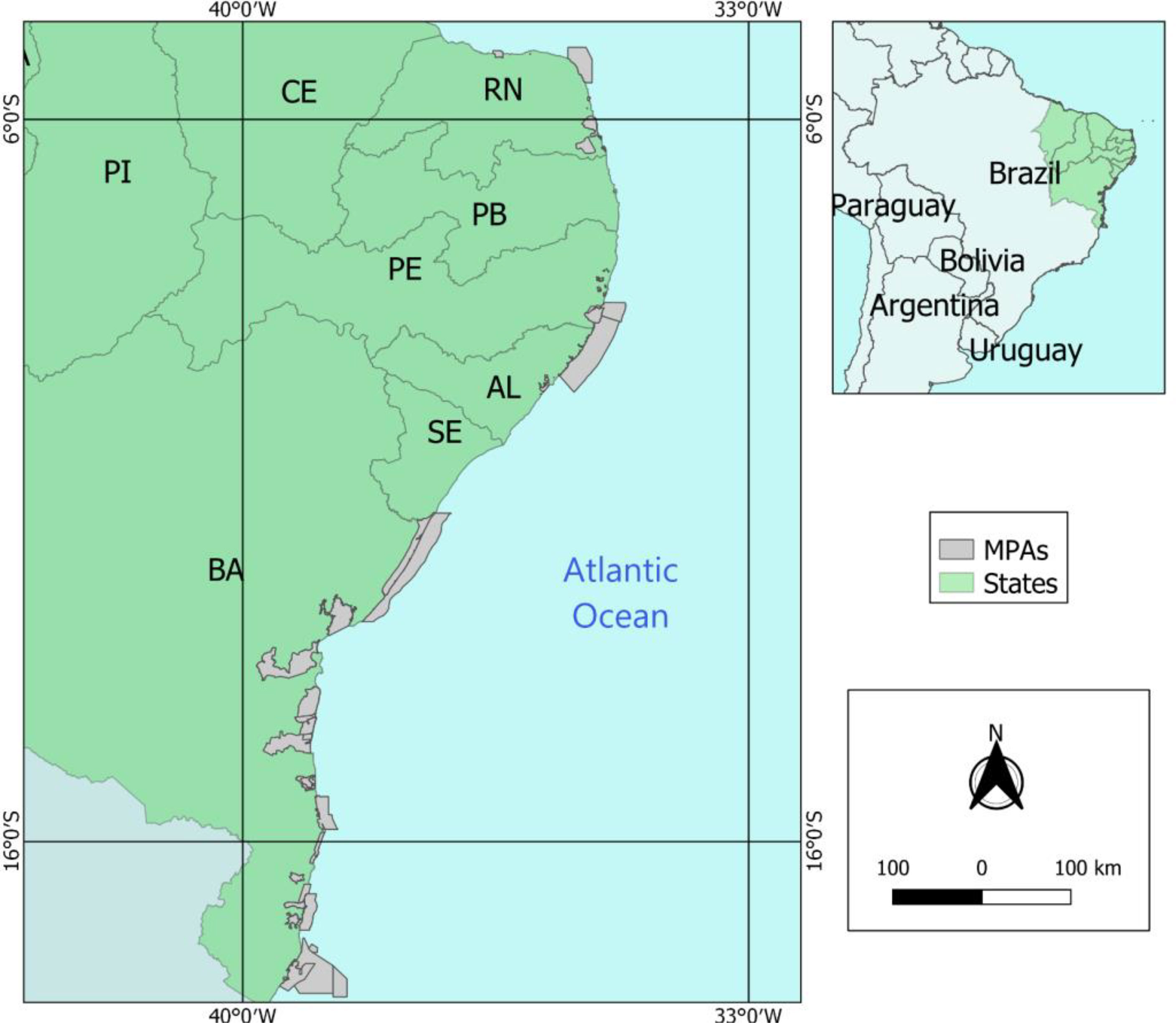
Figure 1 Localities in marine protected areas (MPAs) on the northeastern coast of Brazil (South Atlantic). Highlighted in gray color, affected by oil spill (2019/2020). MPAs in four (AL, PE, RN, and BA) different Brazilian states. Alagoas state (AL); Bahia state (BA); Ceará state (CE); Paraı́ba state (PB); Pernambuco state (PE); Piauı́ state (PI); Rio Grande do Norte state (RN); Sergipe state (SE).
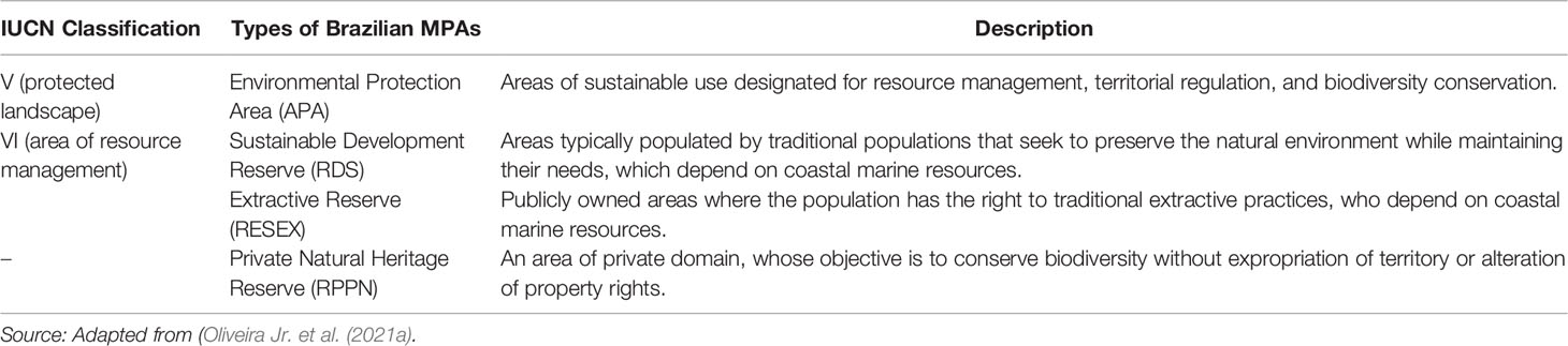
Table 1 Description of the types of MPAs in Brazil analyzed in this research and correlation with the international classification by IUCN (International Union of Conservation Nature).
Proposal of the Socioeconomic Vulnerability Indicator
Based on our objectives, we conducted an exploratory qualitative and quantitative study, gathering information through a survey of primary and secondary data to design a robust indicator for socioeconomic vulnerability. For this, the indicator developed was segmented, following the methodology by Câmara et al. (2021). We used secondary sources from: 1) My Maps, a platform linked to Google Maps, used here for creating digital maps; 2) Institute of Applied Economic Research (IPEA)–this federal institution compiles national data from the demographic census conducted by the Brazilian Institute of Geography and Statistics (IBGE, 2020), producing a social vulnerability index by localities at the national, state, and local levels. In addition, data were collected from the Human Development Index of the municipalities; 3) and the Brazilian Institute for the Environment and Renewable Natural Resources (IBAMA), which gathers georeferenced data of the oil spill, in addition to information regarding the number of days that each location remained oiled.
We analyzed 68 sites within the boundaries of 60 MPAs of different management categories (Table 1), but all sites designated for sustainable use were directly or indirectly affected by the oil spill (Soares et al., 2022). The studied sites were delimited by a territorial space of 25 km, using georeferenced oiled beaches, following the methods of (Nelson et al. 2015; Nelson and Grubesic (2018); (2018) and Câmara et al. 2020; 2021). The localities were grouped into 25 km grid cells, resulting in a total of 37 digital maps. Fifteen localities where oil spill were not directly sighted but experienced indirect socioeconomic impacts (Table S1, Supplementary Material). These localities were grouped into areas larger than 25 km (Figure 1), so that it was possible to establish as a reference point the location of the oil slick closest to these indirectly affected human communities. And to standardize the spaces used, these areas were also divided into three strata (8km, 16km, and 25km), using similar distance bands (~ 8km) measurements (Variable2 to follow), according to the proximity of the establishments to the spill (Câmara et al., 2020; Câmara et al., 2021).
From this delimited area, all social or economic institutions and the main tourist spots were recorded, organized, and cataloged manually. The institutions were separated into different layers according to the type of economic activity (Table S2, Supplementary Material). The data available on this platform were provided collaboratively, quality checked, and made available to all researchers using the validated methodology published by (Câmara et al., 2020; 2021), for generating treated maps on the free Qgis platform.
The socioeconomic vulnerability indicator (VI) of these regions in MPAs was measured using the following equation proposed by (Câmara et al., 2020; 2021), which was adapted from Nelson and Grubesic (2018) and (Nelson et al., 2015; 2018). In addition, the variables suggested for the indicator are shown in Table 2. It is noteworthy that the proposal by (Câmara et al., 2020; 2021) is limited to the economic aspects of the region to compose the indicator. Therefore, in this paper, in addition to secondary data regarding the social conditions of the communities, it was opted to increase the evaluation of specialists who carried out fieldwork in the traditional human communities on the Brazilian coastline. It should be noted that the standardized unit of variables S1 to S3 were based on (Câmara et al., 2020; 2021), while S4 to S6 are proposed here for the first time, following the standards established by the cited authors (Table 2).
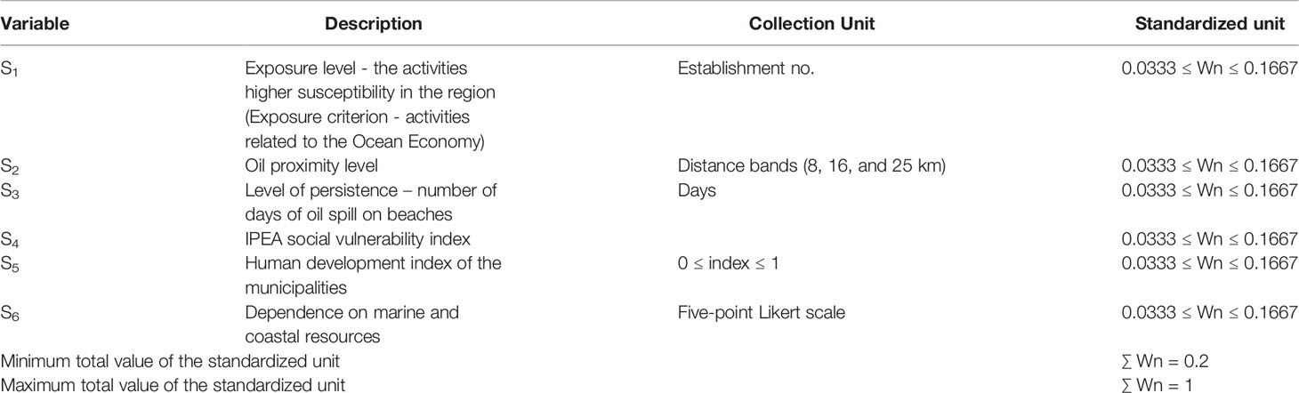
Table 2 Description of the variables of the socioeconomic vulnerability indicator and respective units of analysis, which were based on Câmara et al., (2020; 2021).
Where:
VIa = Vulnerability of an area in MPAs;
Sj = Vulnerability of the j-nth score in the calculated area.
The measurement of Sj was segmented into six variables (Table 2). In the first (S1), the activities were separated into two groups to identify those with higher susceptibility in the region (according to the exposure level) (Table 2). For this, the criteria adopted by Carvalho (2018) and applied by (Câmara et al., 2020; 2021) were used. This was based on the level of vulnerability and classification of activities, whether related to the Ocean Economy or not, dividing the activities that used the inputs of the sea or benefited from a relationship with the sea from economic activities with no relationship with the marine environment (Table 2 in S1). Therefore, we used a standardized way to classify the social, economic and tourism resources for the Brazilian region to assess activities by sector (The National Classification of Economic Activities – NCEA).
The second variable (S2) of the index aimed to define different levels of vulnerability within the analyzed area affected by the oil spill (Table 2). Therefore, the 25 km area was divided into three smaller distance bands (8, 16, and 25 km), according to the proximity of the establishments to the spill, assigning a higher weight to the areas farthest from the oil spill (25 km) and a lower weight to the closest (8 km) (Table 2) (Câmara et al., 2020; Câmara et al., 2021). The division of the areas without spot sightings was proportional to the measurements of the others (Table S1, Supplementary Material), keeping three segmentations of similar sizes and having the closest oil stain as a reference point. Thus, the greater the proximity of these economic and social activities to the oil spill, the greater the likelihood of socioeconomic impact (Câmara et al., 2021).
For the third variable (S3), the level of persistence (number of days) of oil spill on beaches and the daily monitoring of beach cleanliness status (IBAMA, 2019) were taken into account (Table 2). Such tropical areas were concentrated in MPAs, with constant tourist flow due to their scenery and natural beauty (i.e., beach tourism). Consequently, the greater the exposure to oil, the lower their attractiveness to tourists and the greater their social, economic, and environmental vulnerability (Andrade et al., 2010; Nelson et al., 2015; Nelson et al., 2018; Ribeiro et al., 2020; Câmara et al., 2021). To facilitate the composition of these data in the VI, the localities were separated into quartiles, and the lowest weight (W1) was attributed to the beaches with the least time (days) of exposure to oil stains, and the highest (W5) was attributed to those with the longest exposure time (Table 2).
The fourth variable (S4), we used the newest Brazilian social vulnerability index published by the federal government (IPEA, 2010). This indicator was separated into three dimensions: the state of income and labor, degree of urban infrastructure, and human capital (composed of the population’s health and education conditions) (IPEA, 2010).
The fifth variable (S5), used also the data of (IPEA 2010) and prioritized the human development index of the municipalities affected by the spill. Both variables were separated into quartiles, and, like the third variable, the vulnerability was inversely proportional to the indices, so the highest value (W5) was attributed to the localities with the worst performance, and the lowest value (W1) was attributed to those with the best performance (Table 2).
Finally, the sixth variable (S6) in the vulnerability index comprised primary sources compiled from focus groups, whose purpose was to assess the specificities of each location with specialists and scientists who had field experience in these regions (Table 2). This group of specialists was part of the INCT-AmbTropic (National Institute of Science and Technology for the Tropical Marine Environment) and PELDs (Long Term Ecological Projects), which are national strategic projects involving the marine scientists in Brazil (Section 3 in Supplementary Material). It is noteworthy that all of them carried out fieldwork in the evaluated localities between the years 2020–2021 due to this large oil spill.
As for the VI weights, it was decided to unify the scale of values assigned to the variables (Equation 2), ranging from 0.20 ≤ Wn ≤ 1.00, i.e., the higher the weight of the variable, the greater the susceptibility of the locality (Table 2) (Câmara et al., 2020; Câmara et al., 2021). The assigned values were: W1 = 0.0333; W2 = 0.0667; W3 = 0.1 and W4 = 0.1333 and W5 = 0.1667. Therefore, in S1, which considered the exposure levels of the activities, if the variable was related to the marine economy, it was given the highest weight (W5), while the lowest would receive W1. In S2, the closest establishments had the highest weight (W5), and the most distant received W1. In S3, the same reasoning was applied; beaches with more oiled days were given the highest weight (W5) and vice-versa. In S4 and S5, the effects of the social vulnerability index and human development index were inversely proportional. Therefore, the classes of municipalities with the best index performances received the lowest weight (W5), and those with the best indices had the lowest value (W1). Finally, S6, which refers to the dependence on marine and coastal resources, was evaluated on a five-point Likert scale and, consequently, when the effect of the items on vulnerability was positive, progressive and, negative, the values were inverted. Thus, the following equation adapted from Câmara et al., (2020; 2021) was obtained:
Where:
H = Number of establishments with high proximity to the stain;
M = Number of establishments with medium proximity to the stain;
L = Number of establishments with low proximity to the stain;
W = Weight of exposure level (separation of economic activities by susceptibility, according to their level of relationship with the ocean economy); weight of stain proximity (distance in kilometers from establishments to oil stains), weight of vulnerability persistence (number of days on which beaches remained oiled), weight in the social vulnerability and human development indexes, and weight in the application of the questionnaire on dependence on marine and coastal resources.
T-tests were conducted to compare the two main sample groups in this study: APAs and Resex, in order to test how different types of MPAs affect the responses to oil spill incidents (hypotheses: H1 and H2). These two groups of MPAs were chosen both because they were the most common ones, which allowed statistical testing, and because they are quite distinct. The APAs are protected areas with multiple economic and social uses, including tourism and urban centers, while the RESEX are characterized by artisanal fisheries and traditional human communities (Giraldi-Costa et al., 2020; Mills et al., 2020). Note that data on management effectiveness were collected from variable S6 of VI (Table 2, Supplementary Material).
Finally, to hypothetically test (hypotheses: H1 and H2) whether the two main MPAs groups (APAs and Resex) have significantly different management effectiveness in combating oil spills, we performed an analysis of variance. For that, first he scale validity of the variables forming the construct of effectiveness in oil spill response actions (Supplementary Material) was tested through exploratory factor analysis, whose variance was 76.6%, while the Kaiser-Meyer-Olkin (KMO) and Bartlett’s tests of sphericity reached 0.76 and χ² = 366.4; p < 0.000, respectively.
Results
The 68 human communities that were investigated are distributed across 60 MPAs spread over 29 municipalities. All the mapped MPAs were multiple-use protected areas, and the majority (66.7%) were identified as Environmental Protection Areas (APAs) (IUCN Type V), followed by extractive reserves (RESEX) with traditional human communities (IUCN Type VI), which represented 29.8% of the mapped MPAs. In addition, there were also sustainable development reserves (RDS) and private natural heritage reserves (RPPN), each representing 1.7% of the sample.
Digital Mapping Results
More than 6,500 georeferenced institutions were found and categorized, including food and trade activities, services, tourism and leisure venues, and religious institutions (Table 3).
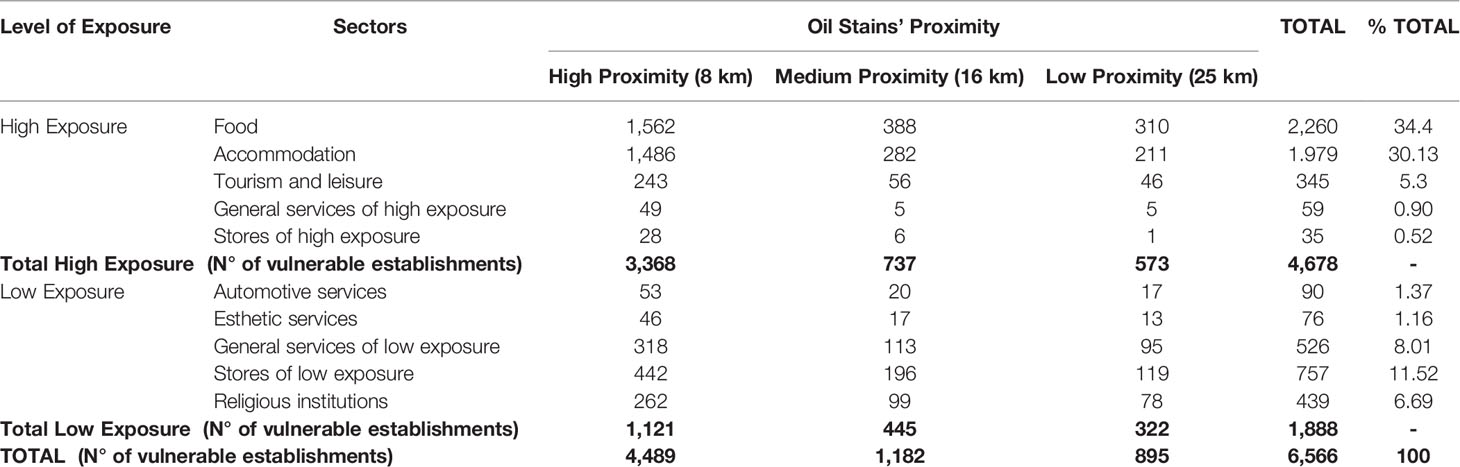
Table 3 Total of institutions categorized by sector and level of exposure of the human communities mapped on boundaries of Marine Protected Areas (MPAs) affected by the oil spill (2019/2020) in the states of Alagoas, Bahia, Pernambuco, and Rio Grande do Norte, located in the Northeast region of Brazil (Southwestern Atlantic).
Most enterprises (34.4%) belonged to the food sector and were related to the ocean economy, and, therefore, were considered to be highly exposed to the effects of the oil spill (Table S2, Supplementary Material). There was also a strong presence of lodging facilities (30.1%) since the human communities in MPAs depend heavily on tourism to move the local economy. Moreover, among the activities unrelated to the ocean economy, there was a strong presence of stores and services in general, which accounted for 11.5% and 8.0% of the mapped enterprises, respectively. Regarding the proximity of the oil spots, it can be seen that in all sectors, most (68.4%) of the establishments were concentrated in the distance band of up to 8 km, highlighting that this percentage is higher in relation to high-exposure services (83%) and accommodation (75%).
Most (79.3%) of the cataloged enterprises were concentrated in APAs, followed by extractive reserves, which accounted for 18.0%. The RPPN and RDS types were less significant at 1.7% and 0.9%, respectively. Food was the most representative sector (34.4%) in the APAs, and the main economic activity was restaurants (12.1% of the establishments in the food sector). In addition, there was a strong presence of snack bars (5.8%), fish markets and shops (5.4%), and bars (3.4%). When evaluating the marine-coastal dependencies, the artisanal fish trade was the primary means of subsistence in the human communities. Less represented (<3%) were beach huts, ice cream parlors or açaí stands, steakhouses, ‘bombonieres’ or confectioneries, coffee shops, and bakeries.
The lodging sector also had a strong presence (31.6%) in the APAs, especially the inns, which accumulated 18.9% of the enterprises in these protected areas. There was also a concentration of activities such as apartments (3.3%), hotels (3.0%), beach house rentals (2.6%), hostels (2.3%), and chalets (1.0%). It is noteworthy that the APAs were the only MPAs that included resort-type establishments, with a presence of 0.4%, half of which were installed in high proximity (8 km) to the oil spill. Finally, it is evident that some activities performed by human communities, such as handicrafts, travel, tourism, ice trade, fishing tool stores, surf articles, sports, or hunting, add up to 1.8% of the enterprises in the regions, and 82.8% of these were concentrated in areas within 8 km of the oil spills.
In the RESEX (extractive reserves), there was also a large concentration of food activities (33.5%), the main enterprise being restaurants (9.7%). However, unlike the APAs, the second most frequent activity was fish markets and stores (7.8%), highlighting the importance of artisanal fisheries in the local economies. In lodging, the second sector (26%) had more activities in the protected areas; again, the inns stood out (15.6%), followed by beach houses (3.3%) and chalets (2.1%). Unlike the APAs, where 74.3% of these enterprises were in close proximity to the oiled spots, only 38.6% of these enterprises were close to oil-affected areas in the extractive reserves.
Finally, in the other MPAs, there was a greater limitation on the number of enterprises. Similarly, the results of the RDS and RPPN show that the food sector predominates on this tropical coast. In both MPAs, fish markets and stores were the majority, representing 11.3% and 10.1% of the enterprises, respectively. In the RDS, inns are the only enterprise that represent the lodging sector (6.5%), all of which are in areas close to oil-spilled areas (8 km). However, in the RPPN, there were also chalets (2.75%) and beach houses (0.9%), in addition to inns (17.4%).
Results of the Vulnerability Indicator (VI)
The VI results are arranged below, highlighting the most vulnerable areas (Figure 2) by cities and their respective MPAs.
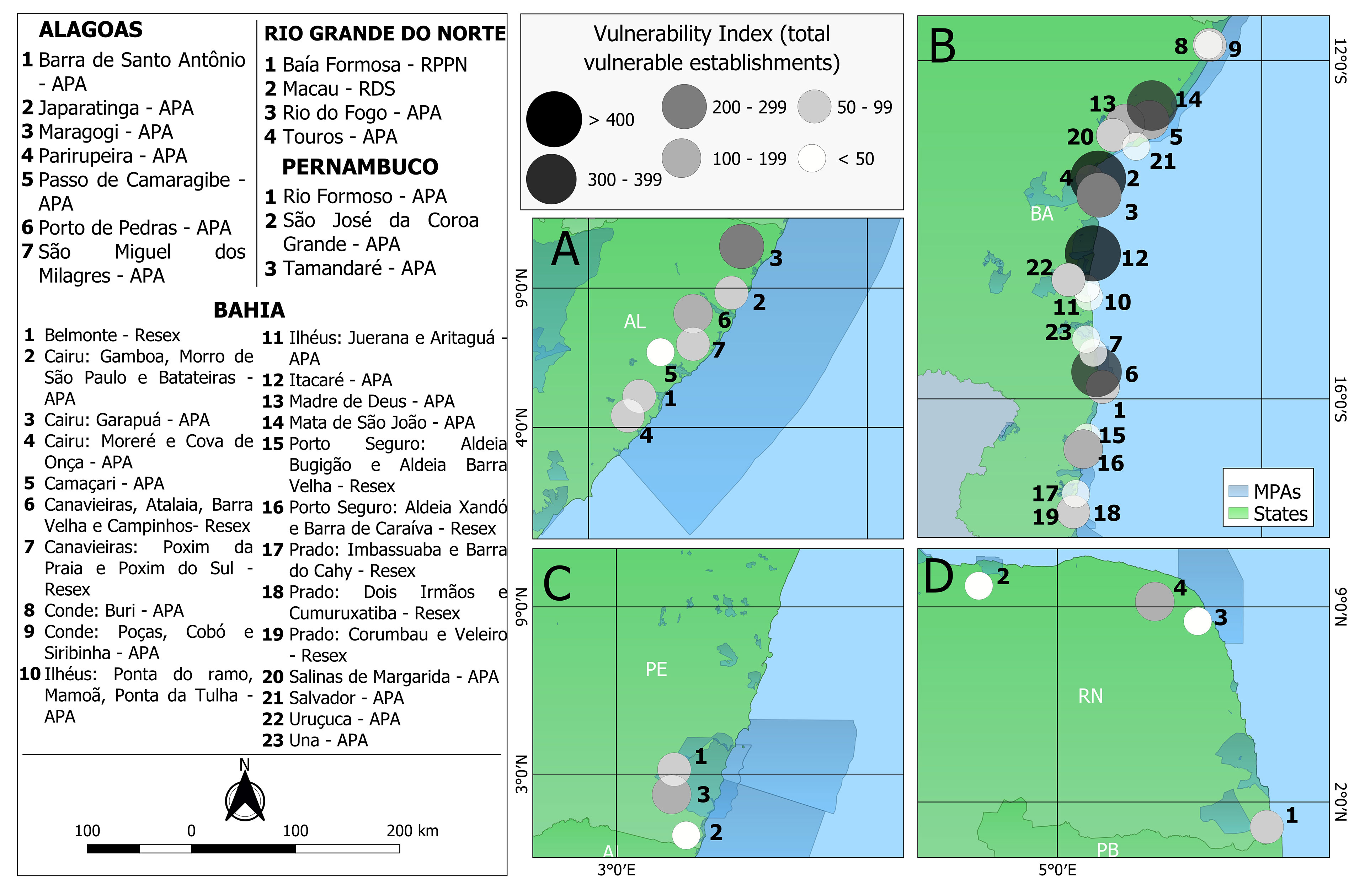
Figure 2 Vulnerability Index (VI) in human communities living in or near the marine protected areas (highlighted by blue color) affected by oil spill (2019/2020), Northeast region of Brazil (Southwestern Atlantic). Human Communities in the states of (A) Alagoas (AL); (B) Bahia (BA); (C) Pernambuco (PE); (D) Rio Grande do Norte (RN).
The vulnerability indicator showed great variation among the localities (Figure 2). In the most vulnerable localities, there was a large concentration of economic activities, compromising 69.6% of establishments that are vulnerable; in the least socioeconomically impacted localities, the indicator is only 4.13 enterprises (<0.1%). It can be inferred that the most socioeconomically affected MPAs, Praia da Concha and Forte (Bahia state), have a vulnerability index of 423.26 enterprises, equivalent to 69.6% of the enterprises in the region. It is noteworthy that, in these locations, there is a high concentration of economic activities within 8 km of the oil spill (92.1% of the establishments), especially in the ocean economy area, which represents 77.1% of the closest enterprises. The second and third highest vulnerabilities were also from the state of Bahia from the Cairu and from the Canavieiras, whose indexes comprised 414.46 and 334.36 establishments, respectively. These indices represent 66.4% of the vulnerable activities in the first locality (Cairu) and 64.6% in the second (Canavieiras).
In Alagoas state, the Maragogi coast has the highest vulnerability, with an index of 284.6 establishments (63.4%). Moreover, in Pernambuco state, the Tamandaré municipality coast has the highest vulnerability with 225.23 establishments (65.6%). In Alagoas, the results of the marine-coastal dependency questionnaire had a significant influence on the indicator since all its localities had the worst evaluations in the collaboration network in both the initial and subsequent actions. Similarly, Maragogi (Alagoas state) had the fourth-worst evaluation in these constructs, reaching an average of the sum of the questions of 2.55 in the initial actions and 2.95 in the later actions (Supplementary Material S3). Finally, the locality of Cajueiro, in the municipality of Touros, in Rio Grande do Norte state, appears in 11th place, with a vulnerability of 138.2 establishments (64.9%). It is noteworthy that, except for Canavieiras and Aldeia Xandó, the other MPA communities mentioned are multiple-use areas such as APAs. In this context, it can be seen that of the first 20 most vulnerable, 80% are APAs, mostly (55%) concentrated in the state of Bahia.
Based on these data, we can infer that the total vulnerability index of communities in APAs is 3,400 establishments. Meanwhile, the indices in RESEX, RPPN, and RDS reached 775.7, 82.5, and 42 establishments, respectively. These values, in percentage terms, indicate that the vulnerability of APAs represents 79.2% of the total vulnerability of the MPAs. Thus, the susceptibility of the APAs is almost five times greater than that of the extractive reserves such as RESEX (the second most vulnerable). In addition, the results from communities where oil spills were not spotted, such as Madre de Deus, in Bahia state, which had the ninth highest vulnerability index, accumulated 152.76 establishments in a state of vulnerability. Therefore, there was significant heterogeneity in the vulnerability index along the tropical coast affected by this oil spill (2019/2020).
The results of the T-test showed a disparity between the MPAs analyzed, since APAs (n = 38; M = 126; t(52.5) = 2.56, p < 0.05) are in fact more susceptible than Resex’s (n = 17; M = 64.7). As for management effectiveness, the results showed that Resex’s (n = 38; M = 0.26; t(52) = 5.5, p < 0.05), despite having a lower potential for socioeconomic loss, have a lower adaptive capacity regarding the management of these spaces than APAs (n = 38; M = 0.61). In this sense, we corroborated hypotheses H1 and H2.
Discussion
We explored the socioeconomic vulnerability status of human populations in MPAs affected by an extensive oil spill for the first time. We were able to determine the coastal socioeconomic vulnerability to impacts, directly or indirectly associated with oiled sites, using locations affected at different levels by the environmental disaster. The results also indicate a spatial heterogeneity of the socioeconomic vulnerability indicator and MPAs along the sites affected by the large-scale spill. In this regard, we discuss the main findings and core results below.
Heterogeneity of the Vulnerability Indicator
The results show how disparate the most extreme values of the indicator are with a large spatial range (658,9 > VI < 7) along the tropical coast. This distance is one of the purposes of vulnerability indicators, allowing the information to prioritize localities according to susceptibility (Andrade et al., 2010; Lins-de-Barros, 2017; Monteiro et al., 2020). Socioeconomic vulnerability is higher in areas with high levels of production and in territories close to the oil spill, similar to the results for the traditional economy affected by this Brazilian disaster (Câmara et al., 2020; Câmara et al., 2021). However, examples of studies in Brazil (Lins-de-Barros, 2017; Araújo et al., 2020; Ribeiro et al., 2020) and worldwide (Andrade et al., 2010; Nelson et al., 2015; Nelson et al., 2018) show that economic activities in small communities may suffer a greater variation in social impact than in large communities affected by an environmental disaster. In this regard, small organizations (e.g., Brazilian artisanal fishers) usually have fewer tools to react to drastic changes in space-time dynamics, either by greatly depending on local resources (Estevo et al., 2021) or by lowering the value of physical, financial, and human capitals. This set of factors commonly reduces their adaptability in the face of disasters such as this sudden oil spill in the southwest Atlantic (Soares et al., 2020; Soares et al., 2022). Thus, structuring a rapidly actionable securitization system in the case of large-scale oil spills is a priority for public policies, as this would allow the productive and social chain to adapt to the new conditions. Unfortunately, this was not the case with this extensive spill, where the response was flawed, slow, and disjointed (Soares et al., 2020; Magalhães et al., 2021; Soares et al., 2022), which amplified social and economic impacts (Magris and Giarrizzo, 2020; Estevo et al., 2021).
This heterogeneous socioeconomic vulnerability indicator is visible, especially in coastal regions with an undiversified economic matrix that is heavily dependent on traditional activities such as fishing, family farming, tourism, accommodation, and the food sector (Ribeiro et al., 2020). This is the case in the study area (NE Brazil), where the main region was affected by the South Atlantic oil spill (Lins-de-Barros, 2017; Araújo et al., 2020; Soares et al., 2020) but also in several communities that are vulnerable to environmental disasters, worldwide. In Brazil, particularly affected sectors, their role in the local economy stands out, where they contribute to the reduction of regional inequalities (Ribeiro et al., 2017; Araújo et al., 2020; Magalhães et al., 2021).
Finally, among the weighting factors established in the indicator (Table 2), variable “dependence on marine and coastal resources” stands out. This dependence is a key variable (Supplementary Material) for evaluating the adaptive capacity of these human communities and the management effectiveness of these MPAs. In addition, this variable evaluates the dedication of these traditional communities to artisanal fisheries, and the development of regional tourism based on natural resources. We hypothesize that the decline of ecosystem goods and services increases the level of susceptibility of these human communities. However, the indicator based on (Câmara et al., 2020; 2021), Nelson and Grubesic (2018) and (Nelson et al. 2015; 2018) does not consider the distinction between oil spill disturbances based on ecosystem services (provisioning, supporting, regulating, and cultural) (Richards et al., 2020). In this regard, further research needs to be done to include these four services for improving the vulnerability indicator.
Furthermore, it should be noted that in the criterion for the division of economic activities (S1), the activities related to the Economy of the Sea were taken into consideration as being more susceptible to oil spills. Among these activities, the results reveal a greater appeal to the food and lodging sectors, which are essential for the functioning of local tourism and require greater attention in the development of public policies that prioritize the adaptive capacity of these activities to possible new threats (Ribeiro et al., 2017; Estevo et al., 2021).
Vulnerability of Human Communities in Marine Protected Areas: APAs x RESEX
Environmental threats as severe as this mysterious and extensive oil spill (Escobar, 2019) pose an exponential challenge to MPAs, compromising productive capacity and long-term sustainable policies (Oliveira Jr. et al., 2021a). Similarly, the socioeconomic impact on these communities depends on several factors related to economic development, including the value of production, generated employment, the level of dependence on activities associated with the ocean economy, and the degree of collaboration among institutions to generate responses to similar disasters (Cinner and Pomeroy, 2012; Alves et al., 2014; Câmara et al., 2020; Câmara et al., 2021; Estevo et al., 2021). Therefore, each locality’s vulnerability threshold will be situational and diverse (Chen and Lopez-Carr, 2015; Chen et al., 2020). In this regard, the results indicated that APAs (multiple-use protected areas with lower restrictions on human activities) were the most vulnerable MPAs, which is expected because they have a relatively higher concentration of economic activities. These areas are intended to manage resources used directly and for territorial regulation, giving them the character of sustainable use (Nicolodi et al., 2021; Oliveira Jr. et al., 2021a). Thus, production in these MPAs should be economically viable, that is, comply with the most stringent sustainability and licensing principles (Schiavetti et al., 2013). However, because of the lower restrictions on the types of enterprises licensed in this type of MPA (e.g., hotels, roads, urbanization) and the low management effectiveness in northeastern Brazil (Oliveira Jr. et al., 2016; Mills et al., 2020), these areas have significant losses in their biodiversity and ecosystem services (Brandão et al., 2017), compromising their level of susceptibility (Grimm et al., 2020).
Management in APAs is more complex due to internal threats (e.g., urbanization and pollution) (Giraldi-Costa et al., 2020) and external threats from environmental accidents (Naughton-Treves et al., 2005; Chen and Lopez-Carr, 2015), such as the oil spill (Magris and Giarrizzo, 2020). In developing countries like Brazil, the challenge is even greater since political instability, coupled with weak governance and inefficient environmental enforcement policies, have generated numerous social, economic, and environmental conflicts due to competition for land use in these MPAs (Oliveira Jr. et al., 2016; Macedo and Medeiros, 2021).
Regarding the RESEX, RDS, and RPPN areas, these are not so vulnerable to oil spills because there is less human occupation, and they are mainly used by traditional communities dependent on fishing (Silva, 2004; Prado et al., 2021). Due to many legal and environmental restrictions, these MPAs are not usually targeted by developments such as resorts or expansive real estate activities. Many of the communities living in these MPAs are low-income families with no livelihood alternatives to fishing, and therefore have difficulties meeting short-term needs and usually focus on subsistence (Santos and Schiavetti, 2014; Oliveira Jr. et al., 2021a). It should be noted that, while the greater socioeconomic vulnerability of the APAs indicates they may suffer greater losses due to their higher economic value, the potential social and food security risks in RESEX, RDS, and RPPNs cannot be disregarded (Estevo et al., 2021; Soares et al., 2022). This is due to the reduced economic dynamism in these areas that causes greater welfare dependence on governmental and non-governmental entities.
Socioeconomic Vulnerability and Social Mobilization Within Marine Protected Areas
Social mobilization, good governance practices and the empowerment of communities living in MPAs are essential for increasing individual and collective well-being (Walpole and Wilder, 2008; Giraldi-Costa et al., 2020) and for mitigating environmental disasters (Cappelli et al., 2021) such as oil spills through participatory processes and rapid responses (Fassina et al., 2020; Soares et al., 2020; Oliveira Jr. et al., 2021a, b). However, traditional communities in developing countries are often opposed to active social participation since they feel that social mobilization through councils and associations is ineffective (Silva, 2004; Santos and Schiavetti, 2014; Chen and Lopez-Carr, 2015). The effectiveness of MPAs depends on engagement level, socioeconomic characteristics, governance, and protective measures against large-scale disasters (Rossiter and Levine, 2014; Gall and Rodwell, 2016). In this sense, the Brazilian communities are involved in locating oil spills and cleaning without support from the federal government (Soares et al., 2020; Magalhães et al., 2021; Soares et al., 2022).
Like other developing nations, social mobilization in communities in NE Brazil is heterogeneous and varies by area and social group (Oliveira Jr. et al., 2021b), which increases socioeconomic vulnerability. For example, on the northern coast of Bahia (the most vulnerable state in the region in the face of an oil spill), real estate speculation has disrupted fishing villages over the years. While the human communities in the extreme south of Bahia are beneficiaries of the Marine Extractive Reserve of Corumbau (Barbosa-Filho et al., 2020), which has proven socio-environmentally effective. Apart from restricting local industrial fishing from other regions, it has contributed to the political organization of these communities (Moura et al., 2009). Currently, this MPA has an active deliberative council, wherein local leaders, scientists, and managers discuss and decide its management (Di Ciommo and Schiavetti, 2012). The fact that this population is essentially composed of indigenous people, a group that has historically mobilized in the fight for guaranteed rights, creates social cohesion and facilities joint local action in the face of disasters such as this oil spill (Araújo et al., 2020; Soares et al., 2020).
The entire north coast of Alagoas State (second most vulnerable state) is occupied by the largest Brazilian nearshore MPA: Environmental Protected Area Coral Coast (Costa dos Corais). Locally, the region is divided into three zones: South Portion, ecological route, and touristic region. Regarding social organization and mobilization in these zones, the South is dominated by artisanal fisheries, a sector with a potentially lower capacity for social organization due to historical and cultural factors and the low income, educational level, and political participation (Cinner et al., 2010). However, fishery colonies and associations in this zone are strongly linked with MPA management and fisheries management at the state level. On the other hand, the ecological route has a balanced prevalence of artisanal fisheries and tourism, especially community-based tourism (Oliveira Jr. et al., 2021a; Oliveira Jr. et al., 2021b). Finally, there is a series of conflicts at the tourism pole between artisanal fishing and the expansion of the hotel and real estate sector (Santos and Schiavetti, 2014). New negative impacts overlie these current conflicts due to oil spills and COVID-19, such as reduced fish sales (Estevo et al., 2021; Magalhães et al., 2021).
Conclusions
The extensive oil spill disaster in Brazil has generated long-lasting socioeconomic and ecological effects. Understanding which factors are of utmost relevance worldwide is vital since these accidents have a direct coastal impact on competition occurring among tourism, urbanization, and other activities (e.g., fishing) especially in developing countries. Therefore, understanding the level of vulnerability of the affected localities, especially MPAs that sustain great biodiversity, is fundamental for preventing losses and understanding the fragility of these areas. Therefore, the novel vulnerability indicator that we constructed for coastal communities of NE Brazil serves as a decision-making support tool to reduce the levels of sensitivity and exposure and increase the adaptive capacity of these areas.
This vulnerability indicator implies potential losses, not actual losses. The idea is to highlight the values with potential exposure to socioeconomic impacts. In this sense, the results are important tools to support the development of science-based public policies, since the information generated reveals not only the areas, but also those economic sectors most susceptible (e.g., fisheries and tourism) to large oil spills. For example, in Praia das Conchas (the most vulnerable area on Brazilian MPAs), restaurants account for 11.5% of the local susceptibility. This sector, therefore, prioritizes specific policies for the development of its adaptive capacity and social resilience to the event, whether in policies for income and job generation or tax incentives to the activity during and after the spill.
These tools are extremely relevant in Brazil because the country has a high level of social inequality among its regions, economic and political instability, and diverse tropical marine biodiversity (Soares et al., 2017). Moreover, in addition to enabling the prioritization of more vulnerable areas, the suggested index also allows us to monitor the main difficulties localities face in coping with the disaster, whether in terms of the delay in environmental recovery or dependence of the local economy on marine resources or tourism. Finally, to enhance the management and governance of disasters of this magnitude, we emphasize the urgent need for studies addressing the following issues: (1) assessment of socioeconomic resilience in MPA communities that faced the oil spill and COVID-19; and (2) measuring socioeconomic vulnerability in other strands associated with environmental, physical, or biological aspects.
Monitoring and mitigation measures must be implemented to minimize the public health, environmental, and socioeconomic impacts of this large spill (Soares et al., 2022). To contribute to the adequate restoration and socioeconomic resilience, we emphasize the need for in-depth research and science-based policies focusing on the following issues: (I) levels and effects of oil contamination in seafood and fishing grounds (Soares et al., 2021); (II) toxicity (e.g., PAHs – polycyclic aromatic hydrocarbons) from oil and its residues in human populations and environmental compartments not evaluated to date (e.g., water, sediment, and biota) (Magalhães et al., 2022); and (III) monitoring of the acute and chronic environmental and socioeconomic impacts on traditional communities and coastal habitats (Soares et al., 2020; Soares et al., 2022). Thus, this study serves not only as a tool to prevent and mitigate economic losses but also to understand the weaknesses of MPAs in the face of large-scale disasters. It may, therefore, help to build socioeconomic and ecological resilience. In this regard, our results indicate that social mobilization and effective governance within MPAs is important for building social resilience against external factors, such as this oil spill.
Data Availability Statement
The original contributions presented in the study are included in the article/Supplementary Material. Further inquiries can be directed to the corresponding author.
Author Contributions
FS – Conceptualization; Data curation; Roles/Writing (original draft); SC – Methodology; Supervision; Writing (review & editing); FP – Supervision; Writing (review & editing); MS – Conceptualization; Supervision; Writing (review & editing); JOJ, RK, GO, MA, AS, GS, PL, NF, MBF, BF, JC-S, FV, JS, and LM – Supervision; Writing (review & editing); CS – Writing (review & editing); VB, PA, and AM – Supervision; Writing (review & editing). All authors contributed to the article and approved the submitted version.
Funding
This paper is a contribution of the Oil Spill Working Group, formed by the consortium of the National Institutes of Science and Technology for the Tropical Marine Environment (INCT-AmbTropic Grant#CNPq 565054/2010-4 and Grant#FAPESB 8936/201, led by José Maria Landim Dominguez), National Institute of Science and Technology Integrated Center of Oceanography (INCT-Mar-COI, Grant#CNPq 610012/2011-8, led by José Henrique Muelbert), and National Institute of Science and Technology for the Integrated Studies of Oceanographic Studies from the Shelf to the Slope (INCT PRO-OCEANO, Grant#CNPq #565061/2010-0), led by Ricardo Coutinho). We have also the support of the Long Term Ecological Research Programs Costa dos Corais Alagoas (PELD-CCAL #441657/20168), Brazilian Semiarid Coast (PELD CSB #442337/2020-5), and Tamandaré Sustentável (PELD TAMS #441632/2016-5). The consortium and the PELD actions were funded by the Ministry of Science, Technology and Innovation of the Brazilian Government. MOS thanks Alexander Von Humboldt Foundation, FUNCAP (Chief-Scientist Program), and CAPES. CNPq also provided research productivity grants to RKPK (# CNPq 311449/2019-0), NNF (#311785/2018-2), MOS (#313518/2020-3), VSB (#311038/2017-4, #316797/2021-9), PFML (#301515/2019-0), and AS (#310464/2020-0). PFML thanks the communities, the researchers/graduate students who contributed with local information (Geovanine Alves, Jaciana Barbosa and Mirian Luiza). FRS thanks Instituto Desenvolvimento, Estratégia e Conhecimento (IDESCO). J.V.C.-S. acknowledge his postdoc positions funded by the Research Council of Norway (grant numbers 295650), funded via the Belmont Forum and BiodivERsA joint call for research proposals, under the BiodivScen ERA-Net COFUND programme, and with the funding organizations French National Research Agency (ANR), São Paulo Research Foundation (FAPESP), National Science Foundation (NSF), the Research Council of Norway (RCN) and the German Federal Ministry of Education and Research (BMBF). GBGS thanks to Anima Institute (AI) for the support and also to the communities (leaders and interviewees) and students/researchers (Lorrane Brito, Débora Santiago, Clara Martinez, Lorena Mota, and Victoria Monteiro) from Salvador University. GBGS also thanks to the Institutional Postdoctoral Program from the Graduate Program in Ecology at the Federal University of Rio de Janeiro (PPGE-UFRJ).
acknowledgments
The authors thank the editor RCP and the three reviewers for their constructive comments and recommendations that improved the manuscript.
Conflict of Interest
The authors declare that the research was conducted in the absence of any commercial or financial relationships that could be construed as a potential conflict of interest.
Publisher’s Note
All claims expressed in this article are solely those of the authors and do not necessarily represent those of their affiliated organizations, or those of the publisher, the editors and the reviewers. Any product that may be evaluated in this article, or claim that may be made by its manufacturer, is not guaranteed or endorsed by the publisher.
Supplementary Material
The Supplementary Material for this article can be found online at: https://www.frontiersin.org/articles/10.3389/fmars.2022.859697/full#supplementary-material
References
Alves T. M., Kokinou E., Zodiatis G. (2014). A Three-Step Model to Assess Shoreline and Offshore Susceptibility to Oil Spills: The South Aegean (Crete) as an Analogue for Confined Marine Basins. Mar. Poll. Bull. 86 (1-2), 443–457. doi: 10.1016/j.marpolbul.2014.06.034
Andrade M. M. N., Szlafsztein C. F., Souza-Filho P. W. M., Reis Araújo A., Gomes M. K. T. (2010). A Socioeconomic and Natural Vulnerability Index for Oil Spills in an Amazonian Harbor: A Case Study Using GIS and Remote Sensing. J. Environ. Manage. 91 (10), 1972–1980. doi: 10.1016/j.jenvman.2010.04.016
Araújo M. E. D., Ramalho C. W. N., Melo P. W. D. (2020). Artisanal Fishers, Consumers and the Environment: Immediate Consequences of the Oil Spill in Pernambuco, Northeast Brazil. Cader. Saúde. Pública. 36, e00230319. doi: 10.1590/0102-311X00230319
Barbosa-Filho M. L., de Souza G. B. G., de Faria Lopes S., Siciliano S., Davis R. A. H., da Silva Mourão J. (2020). Evidence of Shifting Baseline and Fisher Judgment on Lane Snapper (Lutjanus Synagris) Management in a Brazilian Marine Protected Area. Ocean. Coast. Manage. 183, 105025. doi: 10.1016/j.ocecoaman.2019.105025
Brandão C. S., Malta A., Schiavetti A. (2017). Temporal Assessment of the Management Effectiveness of Reef Environments: The Role of Marine Protected Areas in Brazil. Ocean. Coast. Manage. 142, 111–121. doi: 10.1016/j.ocecoaman.2017.03.015
Câmara S. F., Pinto F. R., da Silva F. R., de Oliveira Soares M., De Paula T. M. (2021). Socioeconomic Vulnerability of Communities on the Brazilian Coast to the Largest Oil Spill, (2019–2020) in Tropical Oceans. Ocean. Coast. Manage. 202, 105506. doi: 10.1016/j.ocecoaman.2020.105506
Câmara S. F., Silva F. R., Pinto F. R. (2020). Vulnerabilidade Socioeconômica do Litoral Cearense: Mapeamento Das Localidades Atingidas Pelo Derramamento De Óleo. Cader. Geograf. 30 (62), 817–840. doi: 10.5752/p.2318-2962.2020v30n62p817
Cappelli F., Costantini V., Consoli D. (2021). The Trap of Climate Change-Induced “Natural” Disasters and Inequality. Global Environ. Change 70, 102329. doi: 10.1016/j.gloenvcha.2021.102329
Carvalho A. B. (2018). Economia do Mar: Conceito, Valor E Importância Para O Brasil. (Tese De Doutorado) (Porto Alegre, Brasil: Pontifícia Universidade Católica do Rio Grande do Sul).
Chen C., Lopez-Carr D. (2015). The Importance of Place: Unraveling the Vulnerability of Fisherman Livelihoods to the Impact of Marine Protected Areas. Appl. Geograph. 59, 88–97. doi: 10.1016/j.apgeog.2014.10.015
Chen Q., Su H., Yu X., Hu Q. (2020). Livelihood Vulnerability of Marine Fishermen to Multi-Stresses Under the Vessel Buyback and Fishermen Transfer Programs in China: The Case of Zhoushan City, Zhejiang Province. Int. J. Environ. Res. Public Health 17 (3), 765. doi: 10.3390/ijerph17030765
Cinner J. E., McClanahan T. R., Wamukota A. (2010). Differences in Livelihoods, Socioeconomic Characteristics, and Knowledge About the Sea Between Fishers and non-Fishers Living Near and Far From Marine Parks on the Kenyan Coast. Mar. Policy 34 (1), 22–28. doi: 10.1016/j.marpol.2009.04.003
Cinner J. E., Pomeroy R. S. (2012). People and the Sea: A Festschrift Dedicated to the Career of Richard Pollnac. Coast. Manage. 40 (3), 235–238. doi: 10.1080/08920753.2012.677625
Dalton T., Jin D. (2010). Extent and Frequency of Vessel Oil Spills in US Marine Protected Areas. Mar. Poll. Bull. 60 (11), 1939–1945. doi: 10.1016/j.marpolbul.2010.07.036
Di Ciommo R. C., Schiavetti A. (2012). Women Participation in the Management of a Marine Protected Area in Brazil. Ocean. Coast. Manage. 62, 15–23. doi: 10.1016/j.ocecoaman.2012.02.010
Escobar H. (2019). Mystery Oil Spill Threatens Marine Sanctuary in Brazil. Science 366 (6466), 672–672. doi: 10.1126/science.366.6466.672
Estevo M. O., Lopes P. F., de Oliveira J. G. C. Jr., Junqueira A. B., de Oliveira Santos A. P., da Silva Lima J. A., et al. (2021). Immediate Social and Economic Impacts of a Major Oil Spill on Brazilian Coastal Fishing Communities. Mar. Poll. Bull. 164, 111984. doi: 10.1016/j.marpolbul.2021.111984
Fahd F., Yang M., Khan F., Veitch B. (2021). A Food Chain-Based Ecological Risk Assessment Model for Oil Spills in the Arctic Environment. Mar. Poll. Bull. 166, 112164. doi: 10.1016/j.marpolbul.2021.112164
Fassina C. M., Telles D. H. Q., Mazzuco A. C. A. (2020). Governance Challenges for the Newest Brazilian Marine Protected Areas: Preliminary Considerations for Stakeholder Participation. Ocean. Coast. Manage. 185, 105067. doi: 10.1016/j.ocecoaman.2019.105067
Gall S. C., Rodwell L. D. (2016). Evaluating the Social Acceptability of Marine Protected Areas. Mar. Policy 65, 30–38. doi: 10.1016/j.marpol.2015.12.004
Giraldi-Costa A. C., Medeiros R. P., Tiepolo L. M. (2020). Step Zero of Marine Protected Areas of Brazil. Mar. Policy 120, 104119. doi: 10.1016/j.marpol.2020.104119
Grimm I. J., Piva J. H. T., Sampaio C. A. C. (2020). “Municipal Private Natural Heritage Reserves: Uses and Attributions of Natural Protected Areas in the City of Curitiba (Pr),” in Ecological Economic and Socio Ecological Strategies for Forest Conservation (Cham: Springer), 227–240. doi: 10.1007/978-3-030-35379-7_12
Harfoot M. B., Tittensor D. P., Knight S., Arnell A. P., Blyth S., Brooks S., et al. (2018). Present and Future Biodiversity Risks From Fossil Fuel Exploitation. Conserv. Lett. 11 (4), e12448. doi: 10.1111/conl.12448
Instituto Brasileiro de Geografia e Estatística (IBGE) (2020) IBGE Cidades. Available at: https://cidades.ibge.gov.br/.
Instituto Brasileiro do Meio Ambiente e dos Recursos Naturais Renováveis (Ibama) (2019) Manchas De Óleo No Litoral do Nordeste. Available at: http://www.ibama.gov.br/manchasdeoleo.
Instituto de Pesquisa Econômica Aplicada (IPEA) (2010) Atlas Da Vulnerabilidade Social. Available at: http://ivs.ipea.gov.br/index.php/pt/.
International Union for Conservation of Nature's (IUCN) (2021) Protected Areas IUCN Global Protected Areas Programme and IUCN World Commission on Protected Areas Delivering the Promise of Sydney. Available at: https://www.iucn.org/theme/protected-areas/.
Lee K. H., Noh J., Khim J. S. (2020). The Blue Economy and the United Nations´ Sustainable Development Goals: Challenges and Opportunities. Environ. Int. 137, 105528. doi: 10.1016/j.envint.2020.105528
Lins-de-Barros F. M. (2017). Integrated Coastal Vulnerability Assessment: A Methodology for Coastal Cities Management Integrating Socioeconomic, Physical and Environmental Dimensions-Case Study of Região Dos Lagos, Rio De Janeiro, Brazil. Ocean. Coast. Manage. 149, 1–11. doi: 10.1016/j.ocecoaman.2017.09.007
Lourenço R. A., Combi T., Alexandre M. R., Sasaki S. T., Zanardi-Lamardo E., Yogui G. T. (2020). Mysterious Oil Spill Along Brazil´s Northeast and Southeast, (2019-2020): Trying to Find Answers and Filling Data Gaps. Mar. Poll. Bull. 156, 111219. doi: 10.1016/j.marpolbul.2020.111219
Macedo H. S., Medeiros R. P. (2021). Rethinking Governance in a Brazilian Multiple-Use Marine Protected Area. Mar. Policy 103235. doi: 10.1016/j.marpol.2018.08.019
Magalhães K. M., Barros K. V. S., Lima M. C. S., Barreira C. C. A. R., Rosa Filho J. S., Soares M. O. (2021). Oil Spill + COVID-19: A Disastrous Year for Brazilian Seagrass Conservation. Sci. Total. Environ. 764, 142872. doi: 10.1016/j.scitotenv.2020.142872
Magalhães K. M., Carreira R. S., Rosa Filho J. S., Rocha P. P., Santana F. M., Yogui G. T. (2022). Polycyclic Aromatic Hydrocarbons (PAHs) in Fishery Resources Affected by the 2019 Oil Spill in Brazil: Short-Term Environmental Health and Seafood Safety. Mar. Poll. Bull. 175, 11334. doi: 10.1016/j.marpolbul.2022.113334
Magris R. A., Giarrizzo T. (2020). Mysterious Oil Spill in the Atlantic Ocean Threatens Marine Biodiversity and Local People in Brazil. Mar. Poll. Bull. 153, 110961. doi: 10.1016/j.marpolbul.2020.110961
Mills M., Magris R. A., Fuentes M. M., Bonaldo R., Herbst D. F., Lima M. C., et al. (2020). Opportunities to Close the Gap Between Science and Practice for Marine Protected Areas in Brazil. Perspect. Ecol. Conserv. 18 (3), 161–168. doi: 10.1016/j.pecon.2020.05.002
Monteiro C. B., Oleinik P. H., Leal T. F., Marques W. C., Nicolodi J. L., Lopes B. D. C. F. L. (2020). Integrated Environmental Vulnerability to Oil Spills in Sensitive Areas. Environ. Poll. 267, 115238. doi: 10.1016/j.envpol.2020.115238
Moura R. L., Minte-Vera C. V., Curado I. B., Francini-Filho R. B., Rodrigues H. D. C. L., Dutra G. F., et al. (2009). Challenges and Prospects of Fisheries Co-Management Under a Marine Extractive Reserve Framework in Northeastern Brazil. Coast. Manage. 37 (6), 617–632. doi: 10.1080/08920750903194165
Naughton-Treves L., Holland M. B., Brandon K. (2005). The Role of Protected Areas in Conserving Biodiversity and Sustaining Local Livelihoods. Annu. Rev. Environ. Resour. 30, 219–252. doi: 10.1146/annurev.energy.30.050504.164507
Nelson J. R., Grubesic T. H. (2018). Oil Spill Modeling: Risk, Spatial Vulnerability, and Impact Assessment. Prog. Phys. Geograph.: Earth Environ. 42 (1), 112–127. doi: 10.1177/0309133317744737
Nelson J. R., Grubesic T. H., Sim L., Rose K. (2018). A Geospatial Evaluation of Oil Spill Impact Potential on Coastal Tourism in the Gulf of Mexico. Comput. Environment Urban Syst. 68, 26–36. doi: 10.1016/j.compenvurbsys.2017.10.001
Nelson J. R., Grubesic T. H., Sim L., Rose K., Graham J. (2015). Approach for Assessing Coastal Vulnerability to Oil Spills for Prevention and Readiness Using GIS and the Blowout and Spill Occurrence Model. Ocean. Coast. Manage. 112, 1–11. doi: 10.1016/j.ocecoaman.2015.04.014
Nicolodi J. L., Asmus M. L., Polette M., Turra A., Seifert C. A. Jr., Stori F. T., et al. (2021). Critical Gaps in the Implementation of Coastal Ecological and Economic Zoning Persist After 30 Years of the Brazilian Coastal Management Policy. Mar. Policy 128, 104470. doi: 10.1016/j.marpol.2021.104470
Oliveira J. G. C. Jr., Campos-Silva J. V., da Silva Batista V. (2021b). Linking Social Organization, Attitudes, and Stakeholder Empowerment in MPA Governance. Mar. Policy 130, 104543. doi: 10.1016/j.marpol.2021.104543
Oliveira J. G. C. Jr., Campos-Silva J. V., Santos D. T. V., Ladle R. J., da Silva Batista V. (2021a). Quantifying Anthropogenic Threats Affecting Marine Protected Areas in Developing Countries. J. Environ. Manage. 279, 111614. doi: 10.1016/j.jenvman.2020.111614
Oliveira J. G. C. Jr., Ladle R. J., Correia R., Batista V. S. (2016). Measuring What Matters–Identifying Indicators of Success for Brazilian Marine Protected Areas. Mar. Policy 74, 91–98. doi: 10.1016/j.marpol.2016.09.018
Oliveira O. M., Queiroz A. F. D. S., Cerqueira J. R., Soares S. A., Garcia K. S., Pavani Filho A., et al. (2020). Environmental Disaster in the Northeast Coast of Brazil: Forensic Geochemistry in the Identification of the Source of the Oily Material. Mar. Poll. Bull. 160, 111597. doi: 10.1016/j.marpolbul.2020.111597
Prado D. S., Seixas C. S., Futemma C. R. T. (2021). From Self-Governance to Shared Governance: Institutional Change and Bricolage in Brazilian Extractive Reserves. Environ. Sci. Policy 123, 106–113. doi: 10.1016/j.envsci.2021.05.016
Ribeiro L. C. S., Silva E. O. V., Andrade J. R. L., Souza K. B. (2017). Tourism and Regional Development in the Brazilian Northeast. Tour. Eco. 23 (3), 717–727. doi: 10.1177/1354816616652752
Ribeiro L. C. D. S., Souza K. B. D., Domingues E. P., Magalhães A. S. (2020). Blue Water Turns Black: Economic Impact of Oil Spill on Tourism and Fishing in Brazilian Northeast. Curr. Issues Tour. 24, 1–6. doi: 10.1080/13683500.2020.1760222
Richards D. R., Law A., Tan C. S. Y., Shaikh S. F. E. A., Carrasco L. R., Jaung W., et al. (2020). Rapid Urbanisation in Singapore Causes a Shift From Local Provisioning and Regulating to Cultural Ecosystem Services Uses. Ecosyst. Serv. 46, 101193. doi: 10.1016/j.ecoser.2020.101193
Rossiter J. S., Levine A. (2014). What Makes a “Successful” Marine Protected Area? The Unique Context of Hawaii′ s Fish Replenishment Areas. Mar. Policy 44, 196–203. doi: 10.1016/j.marpol.2013.08.022
Sajid Z., Khan F., Vietch B. (2020). Dynamic Ecological Risk Modelling of Hydrocarbon Release Scenarios in Arctic Waters. Mar. Poll. Bull. 153, 111001. doi: 10.1016/j.marpolbul.2020.111001
Santos C. Z., Schiavetti A. (2014). Assessment of the Management in Brazilian Marine Extractive Reserves. Ocean. Coast. Manage. 93, 26–36. doi: 10.1016/j.ocecoaman.2014.03.007
Schiavetti A., Manz J., dos Santos C. Z., Magro T. C., Pagani M. I. (2013). Marine Protected Areas in Brazil: An Ecological Approach Regarding the Large Marine Ecosystems. Ocean. Coast. Manage. 76, 96–104. doi: 10.1016/j.ocecoaman.2013.02.003
Silva P. P. (2004). From Common Property to Co-Management: Lessons From Brazil's First Maritime Extractive Reserve. Mar. Policy 28 (5), 419–428. doi: 10.1016/j.marpol.2003.10.017
Soares E. C., Bispo M. D., Vasconcelos V. C., Soletti J. I., Carvalho S. H. V., Oliveira M. J., et al. (2021). Oil Impact on the Environment and Aquatic Organisms on the Coasts of the States of Alagoas and Sergipe, Brazil – A Preliminary Evaluation. Mar. Poll. Bull. 171, 112723. doi: 10.1016/j.marpolbul.2021.112723
Soares M. O., Lotufo T. M. C., Vieira L. M., Salani S., Hadju E., Matthews-Cascon H., et al. (2017). “Brazilian Marine Animal Forests: A New World to Discover in the Southwestern Atlantic,” in Marine Animal Forests (Cham: Springer International Publishing). doi: 10.1007/978-3-319-21012-4_51
Soares M. O., Teixeira C. E. P., Bezerra L. E. A., Paiva S. V., Tavares T. C. L., Garcia T. M., et al. (2020). Oil Spill in South Atlantic (Brazil): Environmental and Governmental Disaster. Mar. Policy 115, 103879. doi: 10.1016/j.marpol.2020.103879
Soares M. O., Teixeira C. E. P., Bezerra L. E. A., Rabelo E. F., Castro I. B., Cavalcante R. M. (2022). The Most Extensive Oil Spill in Tropical Oceans: A Balance Sheet of a Disaster. Environ. Sci. Poll. Res. 29, 19869–19877. doi: 10.1007/s11356-022-18710-4
Keywords: vulnerability indicators, ocean economy, oil spill, socioeconomic factors, marine protected areas
Citation: Silva FRd, Schiavetti A, Malhado ACM, Ferreira B, Sousa CVdP, Vieira FP, Pinto FR, Souza GBGd, Olavo G, Santos JBQd, Campos-Silva JV, Oliveira Júnior JGCd, Messias LT, Barbosa Filho MLV, Accioly MdC, Fabré NN, Abdallah PR, Lopes PFM, Kikuchi RKPd, Câmara SF, Batista VdS and Soares MO (2022) Oil Spill and Socioeconomic Vulnerability in Marine Protected Areas. Front. Mar. Sci. 9:859697. doi: 10.3389/fmars.2022.859697
Received: 21 January 2022; Accepted: 19 April 2022;
Published: 20 May 2022.
Edited by:
Roger C. Prince, Stonybrook Apiary, United StatesReviewed by:
Sirak Robele Gari, Addis Ababa University, EthiopiaArio Damar, Bogor Agricultural University, Indonesia
Copyright © 2022 Silva, Schiavetti, Malhado, Ferreira, Sousa, Vieira, Pinto, Souza, Olavo, Santos, Campos-Silva, Oliveira Júnior, Messias, Barbosa Filho, Accioly, Fabré, Abdallah, Lopes, Kikuchi, Câmara, Batista and Soares. This is an open-access article distributed under the terms of the Creative Commons Attribution License (CC BY). The use, distribution or reproduction in other forums is permitted, provided the original author(s) and the copyright owner(s) are credited and that the original publication in this journal is cited, in accordance with accepted academic practice. No use, distribution or reproduction is permitted which does not comply with these terms.
*Correspondence: Felipe Roberto da Silva, ZmVsaXBlLnJvYmVydG9AYWx1bm8udWVjZS5icg==