 Noelle A. Olsen
 Frank Bahr
 N. David Bethoney
 Anna M. Mercer
 Glen Gawarkiewicz
- 1Commercial Fisheries Research Foundation, Kingston, RI, United States
- 2Department of Physical Oceanography, Woods Hole Oceanographic Institution, Woods Hole, MA, United States
- 3Northeast Fisheries Science Center, National Marine Fisheries Service, Narragansett, RI, United States
Recent warming in the Northeast United States continental shelf ecosystem has raised several concerns about the impacts on the ecosystem and commercial fisheries. In 2014, researchers from the Commercial Fisheries Research Foundation and Woods Hole Oceanographic Institution founded the Shelf Research Fleet to involve fishers in monitoring the rapidly changing ocean environment and encourage sharing of ecological knowledge. The Shelf Research Fleet is a transdisciplinary, cooperative program that trains commercial fishers to collect oceanographic information by deploying conductivity, temperature, and depth (CTD) instruments while commercially fishing. A total of 806 CTD profiles have been collected by the Shelf Research Fleet through December 2022. Participating vessels can view the conductivity and temperature water column profiles they collect in real-time. These profiles help inform their fishing practices and give insights when unexpected species appear in their gear or if their catch composition changes from previous years. The data collected by the Shelf Research Fleet are shared with and processed by researchers from numerous partnering institutions. The Shelf Research Fleet data have been used by researchers to better understand oceanographic phenomena including marine heatwaves, shelf-break exchange processes, warm core rings, and salinity maximum intrusions onto the continental shelf. The scope of the Shelf Research Fleet has grown over time to include efforts to more directly link oceanographic results with biological observations to better understand how changing ocean conditions are affecting commercially important species. This article describes the approach, successes, challenges, and future directions of the Shelf Research Fleet and aims to outline a framework for a cost-effective research program that engages fishers in the collection of oceanographic data, strengthening partnerships between fishing industry members and the scientific community.
1 Introduction
Changes in climate and ocean conditions in the continental shelf and slope regions of the Northwest Atlantic are impacting living marine resources and ecosystems as well as the people and communities who depend on those resources (Gaichas et al., 2014; Colburn et al., 2016; Hare et al., 2016). Two major oceanographic changes include the frequency of marine heatwaves and the patterns of shelf-break exchange processes. Since 1950, there has been an increase in the intensity, duration, and frequency of marine heatwaves in the North Atlantic (Scannell et al., 2016; Großelindemann et al., 2022). Marine heatwaves are regions of large-scale and anomalously warm sea surface temperature (Chen et al., 2014; Scannell et al., 2016). In the Southern New England continental shelf region, the most notable marine heatwave in recent history occurred in 2012 where the sea surface temperature was 1-3°C warmer than the 1982 – 2011 average and lasted about six months (Mills et al., 2013). At the end of 2016, another marine heatwave occurred in this region, lasting about four months with temperature anomalies up to 6°C and salinity anomalies above 1 PSU (Gawarkiewicz et al., 2019; Perez et al., 2021). The marine heatwave in 2017 was likely the main driver of the lowest average chlorophyll a concentration over the Northwest Atlantic continental shelf since 1998 (Gawarkiewicz et al., 2019). There is also concern of prolonged changes to ocean temperatures disrupting seasonal cycles, including alteration of the magnitude and timing of seasonal extremes and stratification (Taboada and Anadón, 2012). In Southern New England, mid-depth salinity maximum intrusions are pushing closer to shore and are saltier than previously reported (Gawarkiewicz et al., 2022). Similarly, warm core rings and Gulf Stream water masses and slope waters are penetrating onto the continental shelf and moving further onshore, potentially shifting the distribution of primary productivity and living marine resources (Gawarkiewicz et al., 2018; Salois et al., 2023).
Large-scale environmental changes can have profound effects on marine organisms’ spatial distribution, abundance, mortality, disease prevalence and severity, growth, settlement, and reproductive cycles. For example, Green et al., 2014 demonstrated the impact of temperature and salinity on the growth, sexual maturity and reproduction, mortality, disease, and catchability of commercially important crab and lobster species. Short-lived species, such as northern shortfin squid Illex illecebrosus and longfin squid Doryteuthis pealeii, are especially sensitive to environmental conditions which can cause large fluctuations in abundance (Mills et al., 2013; Moustahfid et al., 2021). Hare et al. (2016) conducted a climate vulnerability assessment on 82 fish and invertebrate species in the Northeast United States to evaluate the extent to which climate change and decadal variability could impact a species’ abundance or productivity. Their assessment indicated that a number of species were highly or very highly vulnerable to climate impacts and variability, and about half of the species studied would be negatively affected by these changes. Furthermore, Nye et al., 2009 documented that many of New England’s commercially important fish species have already exhibited a northward shift in their distributions as well as a shift into deeper waters due to warming ocean temperatures. Changes in community interactions (e.g., predator-prey dynamics) is a lesser understood consequence of the potential co-migration of shifting fish species in response to changing ocean conditions that may affect fishery dynamics (Hollowed et al., 2013; Cohen and Satterfield, 2020; Kroeker and Sanford, 2022). Although fishers may welcome an influx of new commercially-valuable species in their region, skill development and economic and regulatory constraints may inhibit their ability to harvest these new species. Additionally, if species shift out of the area accessible to the fishery, fishers may be forced to target different species or leave the fishery itself (Pinsky and Fogarty, 2012). Ultimately, climate-related shifts in species’ distributions will have implications for the availability of marine resources to harvesters and could lead to a spatial redistribution of fisheries (Pinsky and Fogarty, 2012; Mills et al., 2013).
In recent years, substantial budget cuts to hydrographic monitoring programs in the Northeast United States region have significantly decreased the amount of oceanographic data available to understand these changing ocean conditions. Additionally, there are prohibitive factors associated with oceanographic sampling including the high costs of instrumentation which requires regular servicing and calibration as well as specialized training (Gawarkiewicz and Malek Mercer, 2019; Van Vranken et al., 2020). Innovative solutions to fisheries and oceanographic monitoring are vital to counteract these budget cuts, and partnering with the commercial fishing industry is one such solution (Gawarkiewicz and Malek Mercer, 2019). A rich history of collaborative research projects with commercial and recreational fishers exists in fisheries science, resource management, and oceanographic monitoring around the globe (National Research Council, 2004; Manning & Pelletier, 2009; Patti et al., 2016; Van Vranken et al., 2020; Ito et al., 2021; Jones et al., 2022).
The benefits of partnering with industry members are well-documented and can include reduced costs of science, increased sampling capacity, utilization of fishers’ knowledge and skills, new fishery opportunities, enhanced communication and trust, increased transparency in the scientific and management process, and relationship building (National Research Council, 2004; Johnson and van Densen, 2007; Feeney et al., 2010; Yochum et al., 2011; Gawarkiewicz and Malek Mercer, 2019; Holm et al., 2020; Steins et al., 2020). Yochum et al. (2011) describes how the degree to which industry partners are involved with the project from the outset affects the potential benefits from a collaborative approach particularly in regards to the amount of trust, communication, and mutual education between the groups, and the confidence of the fishers in the research results. Fishers often target the same species in similar areas over the span of multiple decades and have an in-depth knowledge of localized species distribution and their catch composition (Jones et al., 2022; Mercer et al., 2023 In Press). In addition to specialized biological knowledge, fishers also possess a comprehensive understanding of the local habitat, hydrographic, and weather conditions over time (Manning & Pelletier, 2009; Ashoka Deepananda et al., 2015). Van Vranken et al. (2020) described the utility of fishing gear platforms for sub-surface oceanographic observing systems largely due to the widespread spatial distribution of fishing effort and provided several examples of such programs on a variety of types of vessels worldwide. Van Vranken et al. (2020) concluded that fishing vessels equipped with hydrographic gear could increase the effective observation range as well as provide instrument validation if fishing effort spatially overlaps with higher-resolution observation systems. In the Northern Kyushu prefectures of Japan, Ito et al. (2021) equipped small fishing boats with conductivity, temperature, and depth (CTD) instruments in coastal areas which improved the spatiotemporal resolution of the traditional ocean observation systems.
In 2011, the National Science Foundation held a series of public hearings to discuss the installation and five-year operation of the Ocean Observatories Initiative (OOI) Coastal Pioneer Array off the coast of Southern New England. The OOI Coastal Pioneer Array is an observatory system of moorings, gliders, and autonomous underwater vehicles with the purpose of studying shelfbreak processes and shelf-deep ocean exchange (Gawarkiewicz and Plueddemann, 2020). The shelfbreak region is biologically productive and supports commercial and recreational fishing activities in the area. Throughout the fall of 2011, the Commercial Fisheries Research Foundation (CFRF) facilitated a series of workshops with OOI Coastal Pioneer Array scientists and fishing industry representatives to address concerns related to the placement of the array and provide recommendations to help minimize multi-use conflicts. At these meetings, oceanographers and Woods Hole Oceanographic Institution (WHOI) scientists connected with CFRF scientists and fishing industry members. Some of the fishers shared their observations of changing currents and expressed an interest in learning more about how the ocean was changing. Discussions about the changing shelfbreak ecosystem continued beyond these meetings, and a funding opportunity through the MacArthur Foundation arose six months later to propose a collaborative research effort to investigate these changes and fill data gaps onshore of the OOI Coastal Pioneer Array.
In 2014, the CFRF-WHOI Shelf Research Fleet was founded. The primary idea was to use fishing vessels to collect hydrographic data throughout the year for multiple years to examine seasonal and inter-annual variability of the temperature, salinity, and density fields as well as determine the signatures of several shelfbreak exchange processes. The main project goals included: (i) examining the development and breakdown of the seasonal thermocline; (ii) investigating the frequency, timing, and the extent to which warm, saline intrusions of slope and Gulf Stream waters are penetrating onshore onto the continental shelf; and, (iii) a long-term goal of understanding how factors like the Jet Stream position affects seasonal stratification and temperature and salinity extremes during periods of rapid change. Another important goal was to relate hydrographic variability and shelfbreak exchange processes to important fishery resources as well as on their distributions within Southern New England ecosystems (Gawarkiewicz and Malek Mercer, 2019). Additionally, this program aimed to facilitate knowledge exchange between science partners and fishing industry members related to changing ocean conditions. This article describes the approach and successes of the Shelf Research Fleet, including some operational use cases of the collected data, with the aim to provide a framework for future collaborative, industry-based hydrographic research programs.
2 Methods
2.1 Shelf Research Fleet development and communications
In the summer of 2014, an open call to participate in the Shelf Research Fleet was distributed by CFRF to a list of commercial fishing vessel owners in Rhode Island via postal mail. The application form asked a series of questions about the vessel’s target species, the amount of time spent fishing per year, whether they fish in or transit through the study area, and if they have any previous collaborative research experience. Additional calls to participate were advertised via word of mouth, the CFRF electronic mailing list, and the CFRF Facebook page. Ten commercial fishing vessels were initially selected to participate, and a total of seventeen vessels have contributed to sampling efforts. Location and timing of fishing effort were used to prioritize vessel selection to maximize the sampling potential and area covered. A variety of fishing vessel types have participated in the Shelf Research Fleet including lobster and pot fishers, gillnetters, scallopers, and trawlers. Work agreements were formulated by CFRF and signed by vessel captains which included a brief description of the project goals, vessel responsibilities, monetary compensation, and data sharing plans.
The RBRconcerto CTD instrument (RBR Global, https://rbr-global.com/) was selected for this program due to its high degree of accuracy (± 0.03 mS/cm and ± 0.002°C) as well as its user-friendly operation and RBR Ruskin app interface (Gawarkiewicz et al., 2019). Four CTDs were circulated among the Shelf Research Fleet participants, and a rotating sampling schedule was established to distribute effort across space and time. In the fall of 2014, the research team met with the selected vessel owners to present background information on the project and goals, train the fishers how to use the CTD and tablet, and answer any questions. Printed briefing documents, training materials, and user guides were given to the Shelf Research Fleet participants. There were in-person demonstrations on how to use the CTDs instruments and the Ruskin iPad application at commercial fishing docks in Rhode Island. Frequent communication was particularly important at the start of the project to ensure that any issues with the equipment or methodologies were quickly resolved to minimize frustration.
Once the program was underway, the Shelf Research Fleet research team hosted public meetings roughly twice a year to discuss sampling efforts, summarize and share research results, ask new research questions, share any upcoming funding opportunities, and discuss any oceanographic events (e.g., marine heatwaves, storms, warm core ring related processes) and trends in salinity and temperature occurring in the area. Fishers were provided a platform to share field observations related to biological and physical phenomena, ask questions, and share their own hypotheses. Fishing industry members and scientists external to the Shelf Research Fleet program were allowed to attend these meetings. The meetings were typically hosted at the CFRF office or held at a local fishing gear shop located next to commercial docks and seafood processing plants in Rhode Island. Meetings were held in the early evening to accommodate fishers who go out fishing in the early hours of the day, and attendance was typically higher on dates with unfavorable fishing weather. The COVID-19 pandemic paused in-person ocean conditions meetings and the research team pivoted to using webinars with call-in options to increase accessibility. In between the meetings, members of the fishing industry were encouraged to contact Shelf Research Fleet research partners with questions and observations.
The Shelf Research Fleet research team employed a variety of engagement techniques to disseminate the results from and bring awareness to this program. In addition to publishing data results in scientific journals, more informal media were used to reach broader audiences such as websites, blog posts, press releases, media coverage, and social media. For example, this project has had several National Public Radio (NPR) interviews featuring Shelf Research Fleet participants and WHOI and CFRF scientists. WBUR estimates that their programming reaches about seven million listeners each week (WBUR, 2018). The CFRF maintains a project-specific webpage on the Shelf Research Fleet with a promotional video advertising the program (Available: http://www.cfrfoundation.org/shelf-research-fleet). Additionally, research updates and relevant information were shared via CFRF’s social media pages and newsletters. Figure 1 is a timeline of a variety of the accomplishments of the Shelf Research Fleet including journal publications, media coverage, and the progression of sampling throughout the program. Figure 1 Supplemental Material lists the titles of the media articles and publications and their associated hyperlink or DOI.
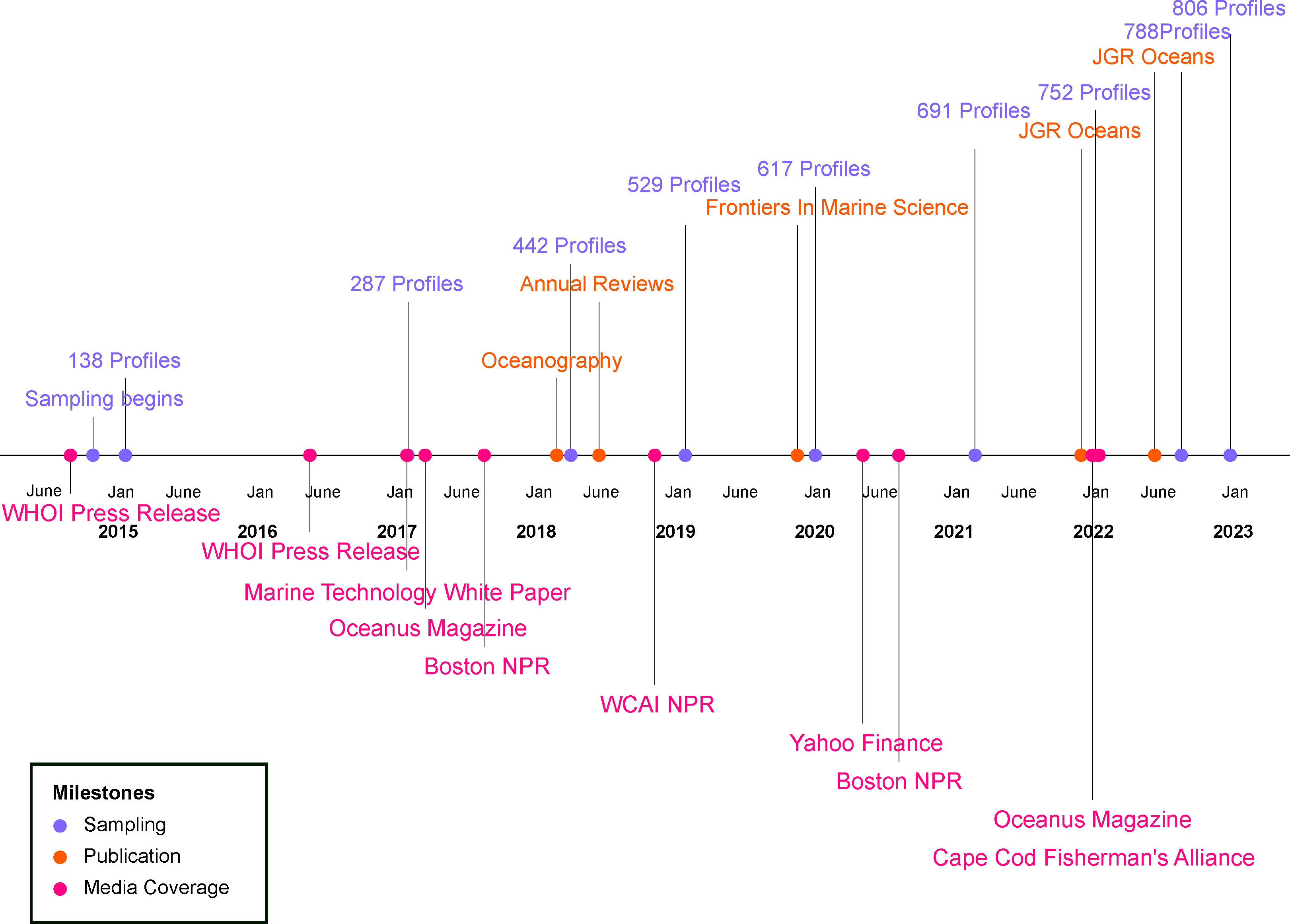
Figure 1 A timeline of Shelf Research Fleet project milestones including the number of Shelf Research Fleet CTD profiles collected, the publication of peer-reviewed journal articles, and a variety of media articles and interviews from September 2014 through December 2022.
2.2 Data collection and processing
Since November 2014, Shelf Research Fleet participants have deployed RBRconcerto CTD instruments across the continental shelf to measure cross-shelf exchange processes. The sampling area was split into six Fishing Zones between the boundaries of 41.305°N to 40°N and 71.5°W to 70.5°W (Figure 2). The total area is about 12,348 km2. Zones 5 and 6 partially overlapped with the OOI Coastal Pioneer Array that was initially deployed at the end of 2013 (Gawarkiewicz and Plueddemann, 2020). However, numerous profiles were collected at fishing locations outside of the longitude boundaries and these have also been analyzed and used in published research (Figures 1, 2). Vessels were typically assigned two Fishing Zones and were asked to conduct a CTD cast in each of their zones weekly. The CTDs were cast over the side of their stationary vessels while they were out commercially fishing and/or transiting through their assigned Fishing Zones. There were minimum monthly sampling requirements to receive the stipend, but individual vessels could sample more if desired. Weekly sampling was targeted from 2015 – 2017 to achieve the spatial and temporal data resolution necessary to capture ocean phenomena like warm core rings interactions and salinity intrusions, but reduced to bi-weekly sampling from 2018 to 2022 due to changes in funding (Gawarkiewicz and Malek Mercer, 2019).
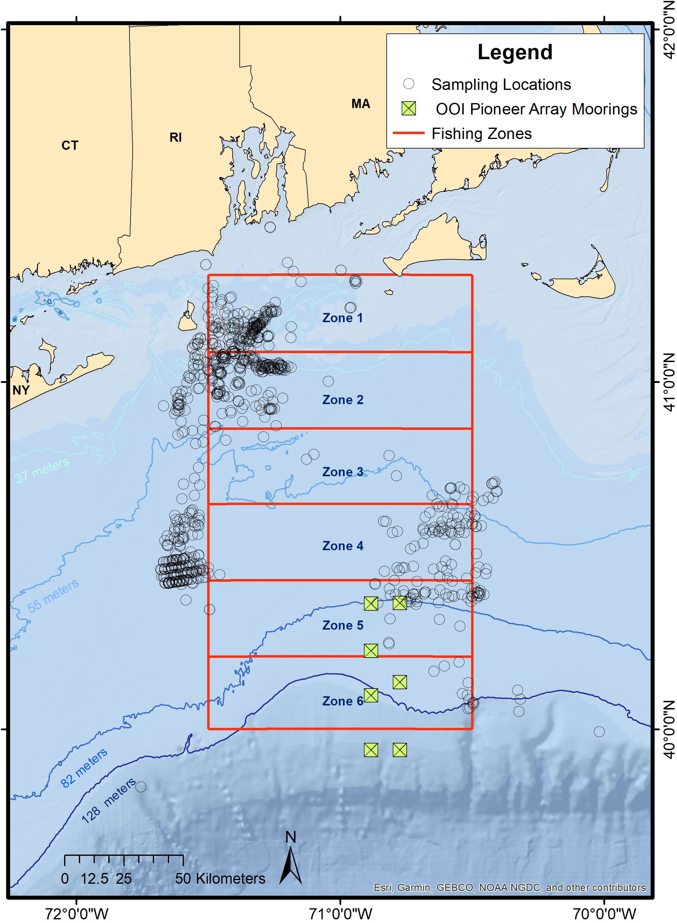
Figure 2 The study area is split into six cross-shelf Fishing Zones. The circles represent the locations of the 806 validated Shelf Research Fleet CTD profiles sampled from November 2014 to December 2022. The Ocean Observatories Initiative Coastal Pioneer Array moorings are represented by the square crosses.
The CTDs measured conductivity and temperature, providing a vertical profile from the water surface to the bottom at each sampling location, and the GPS location was recorded. The CTD profiles were uploaded to the Ruskin app via a Bluetooth connection, the app calculated and displayed salinity and temperature at depth, and the fishers could view the profiles in real time while out at sea. This feature allowed fishers the opportunity to compare their catch to the ocean conditions at the time, help inform their fishing practices, and check whether their CTD cast was successful. Once the vessel returned to the dock and the iPad was connected to WiFi, the CTD profiles were uploaded to science partners at CFRF and WHOI.
At WHOI, temperature and conductivity profiles were combined to derive salinity and density. Only the ascending portion of each profile was used, as surface effects from the rapid deployment of the probe typically contaminated the upper parts of the descending portion. The first few seconds of the ascending path were also removed for a number of profiles that had been contaminated by bottom sediments after landing on the ocean floor. An advantage of the open cell design of the RBR CTD sensor is the capability of allowing quick flushing on the ascent to the surface. Finally, the original 6Hz time series was vertically averaged into one-meter bins. WHOI maintains a publicly available database that provides monthly summaries, visualizes the fisher-collected temperature and salinity profiles by Fishing Zone over the years, and provides access to the Shelf Research Fleet data (Available at https://scienceweb.whoi.edu/seasoar/cfrfwhoi/).
3 Results
3.1 Analysis of Shelf Research Fleet CTD profiles
A total of 806 validated CTD profiles were collected by the Shelf Research Fleet from November 2014 through December 2022 (Figures 1, 2). Weekly and bi-weekly sampling in each Fishing Zone was not always achieved. About 6% of the profiles collected were not included in analyses due to high error readings in the GPS fix in the RBR software, possibly caused by poor GPS reception. Temperature and salinity data collected in Zones 5 and 6 were supplemented by the OOI Coastal Pioneer Array technologies which began implementation in late 2013. Figure 3 displays a time series of the monthly averaged temperature and salinity in each of the Fishing Zones. The eight-year time series of monthly averages help visualize large-scale events such as temperature and salinity anomalies seen in the winter of 2016 – 2017 and in the summer of 2021 (Figure 3).
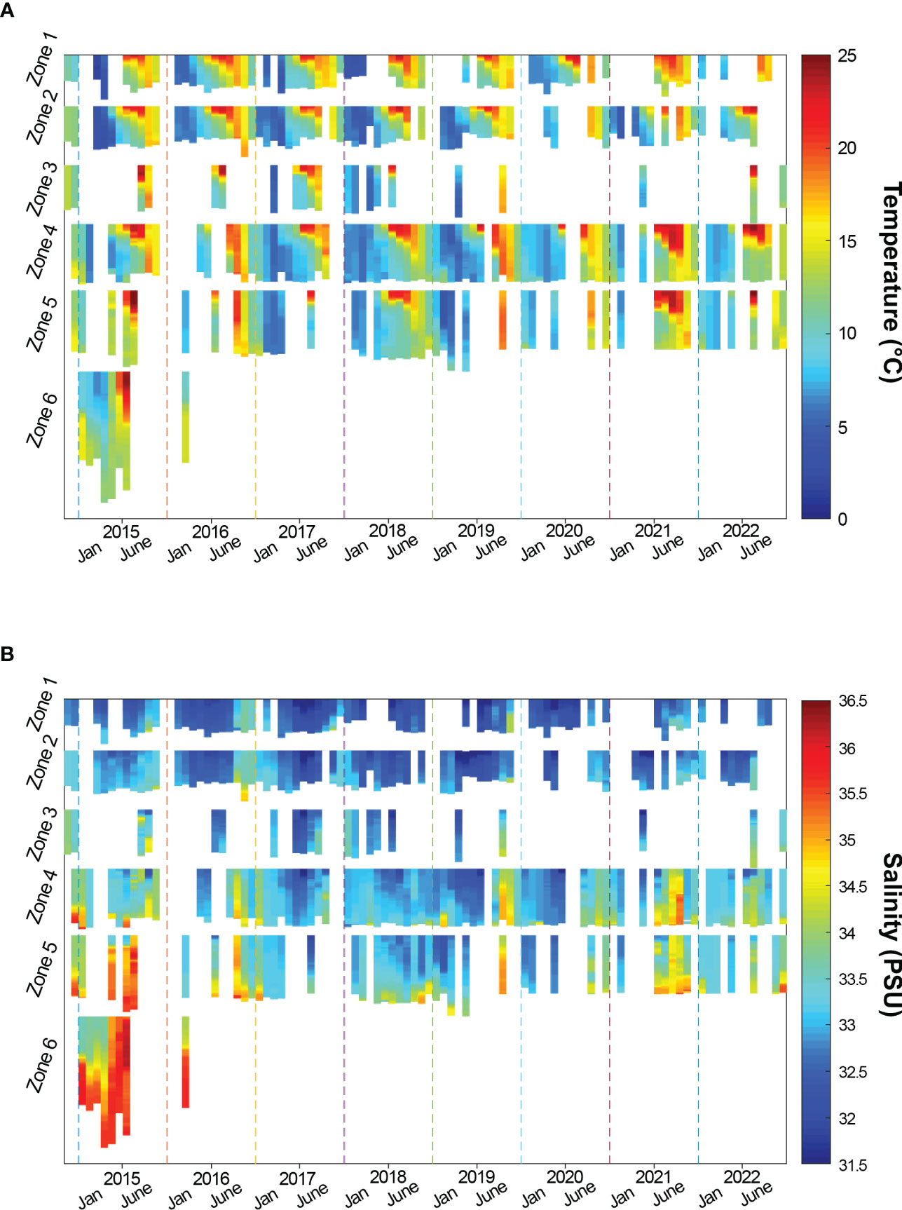
Figure 3 Time series of monthly averaged vertical CTD profiles for (A) temperature (°C) and (B) salinity (PSU) within each of the six Fishing Zones from November 2014 through December 2022. The maximum depth reached by the Shelf Research Fleet CTD profiles ranged from 17 – 52 m in Zone 1, 24 – 60 m in Zone 2, 52 – 77 m in Zone 3, 57 – 80 m in Zone 4, 77 – 122 m in Zone 5, and 119 – 336 m in Zone 6.
The Shelf Research Fleet data have been used to study shelfbreak exchange processes. Figure 4 highlights examples of Shelf Research Fleet CTD profiles that provided insight into several large-scale oceanographic events on the continental shelf and slope regions. For example, in January 2017, Shelf Research Fleet data were used to identify an extensive intrusion of warm, salty water onto the continental shelf, contributing to the documentation of a warm core ring-induced marine heatwave (Chen et al., 2022). Chen et al. (2022) analyzed the dynamics of this intrusion and utilized a numerical hindcast to show that this was primarily a bottom-trapped intrusion. The bottom intrusion reached as far north as Block Island, Rhode Island, nearly 100 km shoreward of the shelfbreak. This marine heatwave event led to warm anomalies over a four-month period over the spatial extent from the Great South Channel, just west of Georges Bank, to Cape Hatteras (Gawarkiewicz et al., 2019). In addition to this event being captured by the Shelf Research Fleet profiles, this event simultaneously was highlighted by commercial fishers who noticed unusual bycatch for winter including Gulf Stream flounder Citharichthys arctifrons and juvenile black sea bass Centropristis striata (Gawarkiewicz et al., 2018). The blue profile in Figure 4 exemplifies an instance in December 2020 in which a bottom water intrusion was occurring and affecting the monkfish Lophius americanus catch for a Shelf Research Fleet participant.
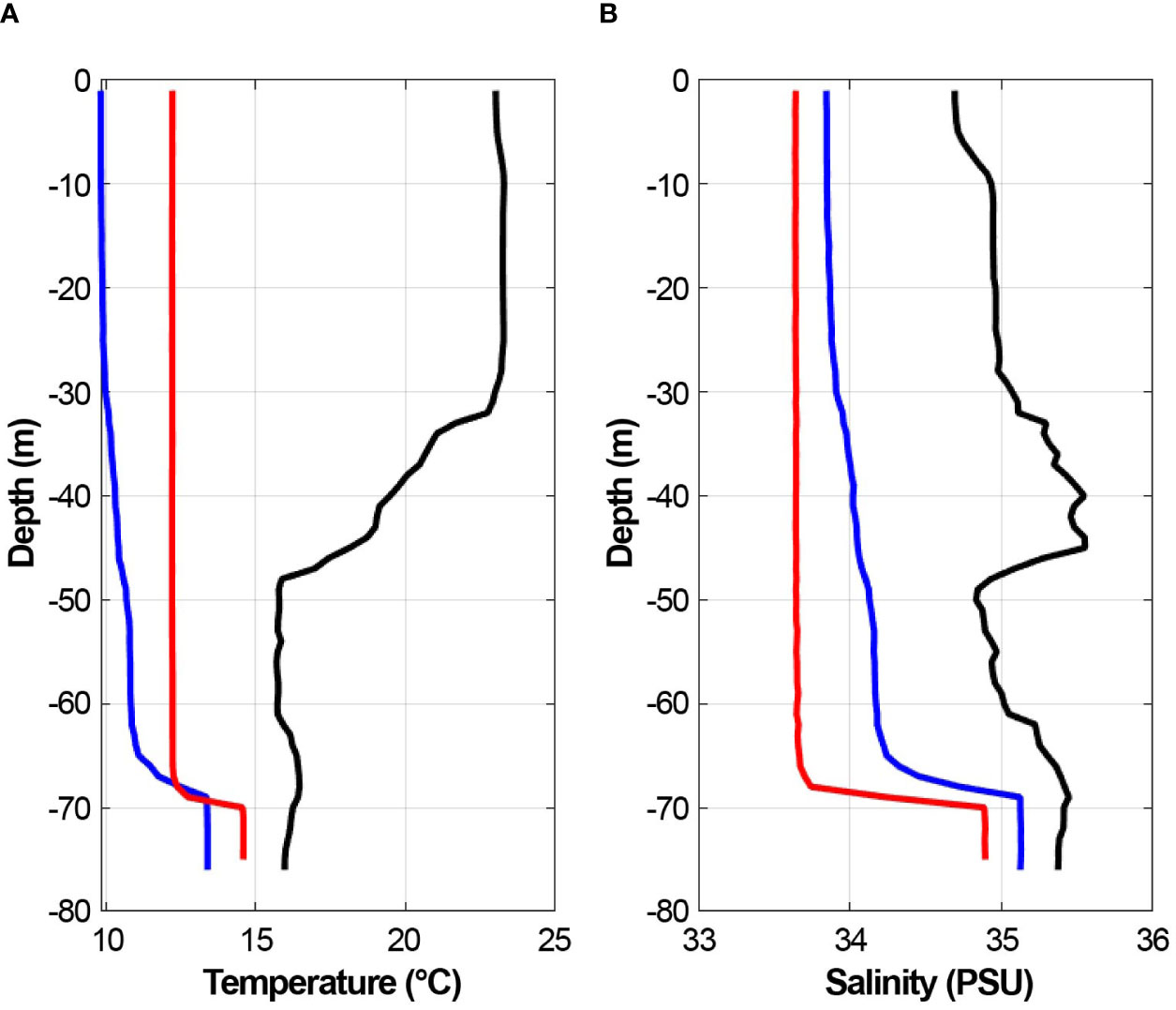
Figure 4 The (A) temperature (°C) and (B) salinity (PSU) at depth (m) of three Shelf Research Fleet CTD profiles showing bottom and mid-depth salinity maximum intrusions. These profiles were sampled in January 2017 (red), December 2020 (blue), and September 2021 (black).
The increasing influence of Gulf Stream water masses is also evident in the increasing frequency of occurrence of mid-depth salinity maximum intrusions. The black profile in Figure 4 is an example of a mid-depth intrusion from September 2021. Shelf Research Fleet profiles from 2015 – 2019 were used in an analysis of historical trends in the characteristics of salinity maximum intrusions and showed a significant increase in the frequency of occurrence relative to the time period 1960 – 1998 (Lentz, 2003; Gawarkiewicz et al., 2022). These intrusions were saltier, featured more complex layering, and about 10% of these profiles contained multiple salinity maxima at different depths. To account for this complexity and reduce ambiguity in analyses, the threshold criterion used to identify salinity maximum intrusions within profiles was increased from ΔS ≥ 0.1 in Lentz (2003) to ΔS ≥ 0.2 in Gawarkiewicz et al. (2022). Thus, the increase in the frequency of occurrence of intrusions over time was likely underestimated (Gawarkiewicz et al., 2022).
3.2 Research applications of Shelf Research Fleet data
The community science efforts using Shelf Research Fleet data have had significant impacts that complemented traditional basic science. Shelf Research Fleet profiles with mid-depth salinity maximum intrusions supported two process-oriented field efforts to map intrusions in three dimensions on the Northeast continental shelf in the summers of 2021 and 2022. Given that salinity maximum intrusions are sub-surface features, traditional tools such as remote sensing could not be used. Shelf Research Fleet participants actively collected more profiles and shared information about fishing and hydrographic conditions in the weeks leading up to the research cruises which ensured an efficient use of ship time. The profiles provided knowledge of the cross-shelf position of the Shelfbreak Front, cold pool temperatures, and stratification in addition to the timing and position of salinity maximum intrusions. Live updates from the research cruises were shared with the Shelf Research Fleet participants when possible.
The Shelf Research Fleet continued to operate throughout the COVID-19 pandemic. While the entire University National Oceanographic Laboratory System fleet of research vessels were suspended from operations, the fishing community was active and collecting data. The Shelf Research Fleet data were important in capturing large temperature anomalies that occurred across the continental shelf in 2020 and 2021. The Shelf Research Fleet collected 127 CTD profiles from March 2020 through the December 2021. The CTD profiles were primarily collected inshore of the Pioneer Array Inshore Mooring, located at the 95 m isobath. This is the mean position of the foot of the Shelfbreak Front. These profiles helped identify bottom intrusions from offshore that could have significant impacts on the catch of benthic species such as lobsters and Jonah crabs. The bottom intrusions may be important in transporting nutrients onto the continental shelf.
The Task Force Ocean New England Shelf Break Acoustics (NESBA) experiment, an Office of Naval Research funded effort, also relied heavily on the collection of data on the continental shelf from the Shelf Research Fleet. The primary focus area of this experiment was between the 100-meter and 1000-meter isobaths over the continental slope. The sampling locations of the Shelf Research Fleet participants naturally supported the NESBA experiment and the CTD profiles provided important information on stratification over the continental shelf shoreward of the ship operations in the spring of 2021. These data were used extensively in developing accurate numerical models for the circulation and thermohaline structure of the shelfbreak environment. This, in turn, was used to develop forecasts for acoustic propagation which can help contribute to National Security Issues.
4 Discussion
The CFRF-WHOI Shelf Research Fleet is an example of a cost-effective sampling program that leverages commercial fishers’ time on the water to help characterize oceanographic processes in Southern New England. Working collaboratively with commercial fishers has increased the availability and timeliness of collecting in-situ water column profiles at a critical time of rapidly changing ocean conditions and simultaneous budget cuts to hydrographic sampling programs in the region (Gawarkiewicz and Malek Mercer, 2019). The OOI Coastal Pioneer Array is expected to be relocated to the Southern Mid-Atlantic Bight between Cape Hatteras and Norfolk Canyon by 2024 which will limit the hydrographic research capacities in the continental shelf and slope regions (Ocean Observatories Initiative, 2022). Thus, the continuation of this project is crucial to monitoring this hydrographically and biologically dynamic region.
A majority of the CTD profiling occurred in the northernmost areas, Zones 1 – 4, which coincides with areas of higher fishing effort by Shelf Research Fleet participants. The targeted sampling rates were not always achieved due to a variety of reasons including bad weather, issues with the equipment, periods when boats were hauled out for repairs, fishing area closures, and periods when captains were unable to devote the time to sampling. A future iteration of the Shelf Research Fleet could include more participating vessels to increase the sampling coverage in the region, help the study area expand elsewhere, and increase the diversity of fisheries involved with the program. CTDs could be equipped with additional probes like a pH sensor to help sample for other emerging issues like ocean acidification. In recent years, RBR has developed additional software to further enhance the data via temporal lagging and filtering, in particular to address salinity spikes around unusually sharp vertical gradients. The Shelf Research Fleet research team hopes to test and implement this code in the future as funding opportunities arise. Although the Shelf Research Fleet participants openly share their catch observations at the public Ocean Conditions meetings, there is no formal process to document and catalog biological observations specifically tied to individual CTD casts. This is currently out of the scope of the participant work agreements. Monetary compensation for increased sampling time, privacy concerns related to individual fishing locations, and possible new technological requirements (e.g., a new tablet or phone application) would need to be considered. Sharing fish logbook information could be a way to expedite the inclusion of catch data (Manning & Pelletier, 2009; Patti et al., 2016).
On a broader scale, the coupling of biological and hydrographic observations has the potential to enhance fisheries management, decision making, and ocean use planning by better understanding the interplay between changing ocean conditions, species’ distributional shifts, and fishery dynamics (Patti et al., 2016; Schmidt et al., 2019; Van Vranken et al., 2020). In addition, scientists and managers could better detect and analyze climate adaptation strategies (Mills et al., 2013). The Shelf Research Fleet research partners participated in the Northern Shortfin Squid Working Group and Research Track Assessment process and will continue to contribute to the understanding of the relationship of shortfin and longfin squid to ocean events like warm core rings and salinity intrusions along the continental shelf and slope regions.
One of the most valuable attributes of the Shelf Research Fleet program has been the ability to view CTD profiles while at sea and pair these data with personal observations of weather events, ocean dynamics, and fishery catch information in real time. The close communication about research results meant that fishers could use the profiles they collected to make significant business decisions, as for example, shifting from fishing to having repairs done on vessels during a time in which a bottom salinity intrusion is occurring (WHOI, 2022b, Audio available at https://www.youtube.com/watch?v=FVmzHeBsCgA). The fishers’ regional expertise in their fisheries increased the research capacity of this project by providing a human dimension that is absent from uncrewed ocean observation tools. Because the CTD profiles were taken primarily where the vessels commercially fish, their observations at sea were critical to contextualizing the hydrographic research within the realm of local fisheries resources. Additionally, the continued enthusiasm and interest in sampling by Shelf Research Fleet participants has helped garnered support from funding agencies to continue and grow this research program over the years.
The Shelf Research Fleet has helped researchers describe and better understand oceanographic phenomena in a rapidly changing environment through a collaborative effort with commercial fishers. In addition to the scientific merits of this collaborative project, the Shelf Research Fleet has also strengthened partnerships between the local scientific and fishing communities while equipping participants with new tools to help them better understand how changing ocean conditions may be affecting their commercial catches. The integration of fishers’ knowledge into the various research applications has strengthened the program’s research capacity and broadened its scope over time. The Shelf Research Fleet research team hopes to continue working collaboratively with commercial fishers to help support research that aids in the advancement of ecosystem-based fishery management efforts in Southern New England.
Data availability statement
The datasets presented in this study can be found in online repositories. The names of the repository/repositories and accession number(s) can be found below: https://scienceweb.whoi.edu/seasoar/cfrfwhoi/.
Author contributions
GG and AM contributed to conception and design of the study. FB and GG performed data analyses. FB managed the database. FB and NO contributed figures. NO wrote the first draft of the manuscript. All authors contributed to the text, revisions, and approval of the submitted manuscript.
Funding
Data collection for the Shelf Research Fleet and salary for NO, GG, and FB, were provided by the van Beuren Charitable Foundation of Newport, RI and the MacArthur Foundation. The office of the Director of Research at WHOI also supported GG and supported additional funding for the Shelf Research Fleet data collection through WHOI grant #A101591. The analysis of these data and writing of this manuscript were supported by the National Science Foundation grant OCE-1851261.
Acknowledgments
We thank the captains and crew of the participating vessels who have contributed to the sampling efforts for this project. We also thank the members of the fishing industry and scientists who have participated in the ocean conditions meetings over the years, contributing to the ongoing discussions about how changing oceans are affecting Southern New England’s living marine resources. We also thank Aubrey Ellertson and Susan Inglis for their work to support the Shelf Research Fleet and related outreach efforts. We gratefully acknowledge the support of the MacArthur Foundation, van Beuren Charitable Foundation, National Science Foundation, and Woods Hole Oceanographic Institution.
Conflict of interest
The authors declare that the research was conducted in the absence of any commercial or financial relationships that could be construed as a potential conflict of interest.
Publisher’s note
All claims expressed in this article are solely those of the authors and do not necessarily represent those of their affiliated organizations, or those of the publisher, the editors and the reviewers. Any product that may be evaluated in this article, or claim that may be made by its manufacturer, is not guaranteed or endorsed by the publisher.
Supplementary material
The Supplementary Material for this article can be found online at: https://www.frontiersin.org/articles/10.3389/fmars.2023.1144178/full#supplementary-material
References
Ashoka Deepananda K. H. M., Amarasinghe U. S., Jayasinghe-Mudalige U. K., Berkes F. (2015). Stilt fisher knowledge in southern Sri Lanka as an expert system: a strategy towards co-management. Fisheries Res. 174, 288–297. doi: 10.1016/j.fishres.2015.10.028
Chen K., Gawarkiewicz G. G., Lentz S. J., Bane J. M. (2014). Diagnosing the warming of the northeastern U.S. coastal ocean in 2012: a linkage between the atmospheric jet stream variability and ocean response. J. Geophys. Res. Oceans. 119, 218–227. doi: 10.1002/2013JC009393
Chen K., Gawarkiewicz G. G., Yang J. (2022). Mesoscale and submesoscale shelf-ocean exchanges initialize an advective marine heatwave. J. Geophys. Res. Ocean. 127, 1–28. doi: 10.1029/2021JC017927
Cohen E. B., Satterfield D. A. (2020). ‘Chancing on a spectacle:’ co-occurring animal migrations and interspecific interactions. Ecography 43, 1657–1671. doi: 10.1111/ecog.04958
Colburn L. L., Jepson M., Weng C., Seara T., Weiss J., Hare J. A. (2016). Indicators of climate change and social vulnerability in fishing dependent communities along the Eastern and gulf coasts of the united states. Mar. Policy. 74, 323–333. doi: 10.1016/j.marpol.2016.04.030
Feeney R. G., La Valley K. J., Hall-Arber M. (2010). Assessing stakeholder perspectives on the impacts of a decade of collaborative fisheries research in the gulf of Maine and georges bank. Mar. Coast. Fish. 2, 205–216. doi: 10.1577/C09-038.1
Gaichas S. K., Link J. S., Hare J. A. (2014). A risk-based approach to evaluating northeast US fish community vulnerability to climate change. ICES J. Mar. Sci. 71 (8), 2323–2342. doi: 10.1093/icesjms/fsu048
Gawarkiewicz G., Chen K., Forsyth J., Bahr F., Mercer A. M., Ellertson A., et al. (2019). Characteristics of an advective marine heatwave in the middle Atlantic bight in early 2017. Front. Mar. Sci. 6. doi: 10.3389/fmars.2019.00712
Gawarkiewicz G., Fratantoni P., Bahr F., Ellertson A. (2022). Increasing frequency of mid-depth salinity maximum intrusions in the middle Atlantic bight. J. Geophys. Res. 127, e2021JC018233. doi: 10.1029/2021JC018233
Gawarkiewicz G., Malek Mercer A. (2019). Partnering with fishing fleets to monitor ocean conditions. Ann. Rev. Mar. Sci. 11, 6.1–6.21. doi: 10.1146/annurev-marine-010318-095201
Gawarkiewicz G., Plueddemann A. J. (2020). Scientific rationale and conceptual design of a process-oriented shelfbreak observatory: the OOI pioneer array. J. Oper. Oceanogr. 13 (1), 19–36. doi: 10.1080/1755876X.2019.1679609
Gawarkiewicz G., Todd R. E., Zhang W., Partida J., Gangopadhyay A., Monim M. U. H., et al. (2018). The changing nature of shelf-break exchange revealed by the OOI pioneer array. Oceanography 31 (1), 60–70. doi: 10.5670/oceanog.2018.110
Green B. S., Gardner C., Hochmuth J. D., Linnane A. (2014). Environmental effects on fished lobsters and crabs. Rev. Fish Biol. Fish. 24, 613–638. doi: 10.1007/s11160-014-9350-1
Großelindemann H., Ryan S., Ummenhofer C. C., Martin T., Biastoch A. (2022). Marine heatwaves and their depth structures on the northeast U.S. Continental Shelf. Front. Clim. 4. doi: 10.3389/fclim.2022.857937
Hare J. A., Morrison W. E., Nelson M. W., Stachura M. M., Teeters E. J., Griffis R. B., et al. (2016). A vulnerability assessment of fish and invertebrates to climate change on the northeast U.S. continental shelf. PloS One 11 (2), e0146756. doi: 10.1371/journal.pone.0146756
Hollowed A. B., Barange M., Beamish R. J., Brander K., Cochrane K., Drinkwater K., et al. (2013). Projected impacts of climate change on marine fish and fisheries. ICES J. Mar. Sci. 70 (5), 1023–1037. doi: 10.1093/icesjms/fst081
Holm P., Hadjimichael M., Linke S., Mackinson S. (2020). Bridging the gap: collaborative research practices in the fisheries (Amsterdam: Springer), 320. doi: 10.1007/978-3-030-26784-1
Ito T., Nagamoto A., Nabuo T., Nobuteru K., Kokubo T., Takikawa T., et al. (2021). Construction of CTD hydrographic observation system by fishermen in northwest Kyushu, Japan. Bull. Jpn. Soc Fish. Oceanogr. 85 (4), 197–203. doi: 10.34423/jsfo.85.4_197
Johnson T., van Densen W. L. T. (2007). The benefits and organization of cooperative research for fisheries management. ICES J. Mar. Sci. 64, 834–840. doi: 10.1093/icesjms/fsm014
Jones A. W., Burchard K. A., Mercer A. J. M., Hoey J. J., Morin M. D., Gianesin G. L., et al. (2022). Learning from the study fleet: maintenance of a Large-scale reference fleet for northeast U.S. fisheries. Front. Mar. Sci. 9. doi: 10.3389/fmars.2022.869560
Kroeker K., Sanford E. (2022). Ecological ecological leverage points: species interactions amplify the physiological effects of global environmental change in the ocean. Annu. Rev.Mar. Sci. 14, 75–103. doi: 10.1146/annurev-marine-042021-051211
Lentz S. J. (2003). A climatology of salty intrusions over the continental shelf from georges bank to cape hatteras. J. Geophys. Res. 108, 24.1–24.12. doi: 10.1029/2003JC001859
Manning J., Pelletier E. (2009). Environmental monitors on lobster traps (eMOLT): long-term observations of new england’s bottom-water temperatures. J. Oper. Oceanogr. 2 (1), 25–33. doi: 10.1080/1755876X.2009.11020106
Mercer A. J. M., Manderson J. P., Lowman B. A., Salois S., Hyde K. J. W., Pessutti J., et al. (2023). Bringing in the experts: application of industry knowledge to advance catch rate standardization for northern shortfin squid (Illex illecebrosus). Front. Mar. Sci. 10. doi: 10.3389/fmars.2023.1144108
Mills K. E., Pershing A. J., Brown C. J., Chen Y., Chiang F. S., Holland D. S., et al. (2013). Fisheries management in a changing climate: lessons from the 2012 ocean heat wave in the Northwest Atlantic. Oceanography 26 (2), 191–195. doi: 10.5670/oceanog.2013.27
Moustahfid H., Hendrickson L. C., Arkhipkin A., Pierce G. J., Gangopadhyay A., Kidokoro H., et al. (2021). Ecological-fishery forecasting of squid stock dynamics under climate variability and change: review, challenges, and recommendations. Rev. Fish. Sci. Aquac. 29 (4), 682–705. doi: 10.1080/23308249.2020.1864720
National Research Council (2004). Cooperative research in the national marine fisheries service (Washington, DC: The National Academies Press). doi: 10.17226/10836
Nye J. A., Link J. S., Hare J. A., Overholtz W. J. (2009). Changing spatial distribution of fish stocks in relation to climate and population size on the northeast united states continental shelf. Mar. Ecol. Prog. Ser. 393, 111–129. doi: 10.3354/meps08220
Ocean Observatories Initiative (2022) Coastal pioneer array relocation. Available at: https://oceanobservatories.org/pioneer-array-to-move-to-southern-mid-atlantic-bight-in-2024.
Patti B., Martinelli M., Aronica S., Belardinelli A., Penna P., Bonanno A., et al. (2016). The fishery and oceanography observing system (FOOS): a tool for oceanography and fisheries science. J. Oper. Oceanogr. 9, S99–S118. doi: 10.1080/1755876X.2015.1120961
Perez E., Ryan S., Andres M., Gawarkiewicz G., Ummenhofer C. C., Bane J., et al. (2021). Understanding physical drivers of the 2015/16 marine heatwaves in the Northwest Atlantic. Sci. Rep. 11, 1–11. doi: 10.1038/s41598-021-97012-0
Pinsky M. L., Fogarty M. (2012). Lagged social-ecological responses to climate and range shifts in fisheries. Clim. Change. 115, 883–891. doi: 10.1007/s10584-012-0599-x
Salois S. L., Hyde K. J. W., Silver A. M., Gangopadhyay A., Gawarkiewicz G., Mercer A. J. M., et al. (2023). Shelf break exchange processes influence the availability of the northern shortfin squid, Illex illecebrocus, in the Northwest Atlantic. Fish. Oceanogr. doi: 10.1111/fog.12640
Scannell H. A., Pershing A. J., Alexander M. A., Thomas A. C., Mills K. E. (2016). Frequency of marine heatwaves in the north Atlantic and north pacific since 1950. Geophys. Res. Lett. 43, 2069–2076. doi: 10.1002/2015GL067308
Schmidt J. O., Bograd S. J., Arrizabalaga H., Azevedo J. L., Barbeaux S. J., Barth J. A., et al. (2019). Future ocean observations to connect climate, fisheries and marine ecosystems. Front. Mar. Sci. 6. doi: 10.3389/fmars.2019.00550
Steins N. A., Kraan M. L., van der Reijden K. J., Quirijns F. J., van Broekhoven W., Poos J. J. (2020). Integrating collaborative research in marine science: recommendations from an evaluation of evolving science-industry partnerships in Dutch demersal fisheries. Fish Fish (Oxf). 21, 146–161. doi: 10.1111/faf.12423
Taboada F. G., Anadón R. (2012). Patterns of change in sea surface temperature in the north Atlantic during the last three decades: beyond mean trends. Clim. Change 115, 419–431. doi: 10.1007/s10584-012-0485-6
Van Vranken C., Vastenhoud B. M. J., Manning J. P., Plet-Hansen K. S., Jakoboski J., Gorringe P., et al. (2020). Fishing gear as a data collection platform: opportunities to fill spatial and temporal gaps in operational Sub-surface observation networks. Front. Mar. Sci. 7. doi: 10.3389/fmars.2020.485512
WBUR (2018) About: who we are. Available at: https://www.wbur.org/about (Accessed November 17, 2022).
WHOI (2022a) Ocean data gives northeast fishermen an edge against a warming ocean. Available at: https://www.whoi.edu/oceanus/feature/ocean-data-gives-northeast-fishermen-an-edge-against-a-warming-ocean/ (Accessed April 25, 2023).
WHOI (2022b) Data access gives fishermen edge against warming sea. Available at: https://www.youtube.com/watch?v=FVmzHeBsCgA (Accessed April 25, 2023).
Keywords: warm core rings, salinity maximum intrusions, shelfbreak exchange processes, collaborative research, Southern New England
Citation: Olsen NA, Bahr F, Bethoney ND, Mercer AM and Gawarkiewicz G (2023) Integrating fishers’ knowledge with oceanographic observations to understand changing ocean conditions in the Northeast United States. Front. Mar. Sci. 10:1144178. doi: 10.3389/fmars.2023.1144178
Received: 13 January 2023; Accepted: 09 May 2023;
Published: 23 May 2023.
Edited by:
Steven Mackinson, Scottish Pelagic Fishermen’s Association, United KingdomReviewed by:
Katie Brigden, University of the Highlands and Islands, United KingdomMichela Martinelli, National Research Council (CNR), Italy
Copyright © 2023 Olsen, Bahr, Bethoney, Mercer and Gawarkiewicz. This is an open-access article distributed under the terms of the Creative Commons Attribution License (CC BY). The use, distribution or reproduction in other forums is permitted, provided the original author(s) and the copyright owner(s) are credited and that the original publication in this journal is cited, in accordance with accepted academic practice. No use, distribution or reproduction is permitted which does not comply with these terms.
*Correspondence: Noelle A. Olsen, bm9sc2VuQGNmcmZvdW5kYXRpb24ub3Jn