 Elizabeth T. Methratta
 Andrew Lipsky1
 Jason M. Boucher
- 1Northeast Fisheries Science Center, National Oceanic and Atmospheric Administration (NOAA) National Marine Fisheries Service, Narragansett, RI, United States
- 2Northeast Fisheries Science Center, National Oceanic and Atmospheric Administration (NOAA) National Marine Fisheries Service, Woods Hole, MA, United States
Offshore wind will generate much needed renewable energy in the U.S. and worldwide, but this industry will also affect other ocean uses. In the Northeast U.S. continental shelf (NES) ecosystem, these effects include the impact that wind development will have on the design and execution of long running scientific surveys conducted by National Marine Fisheries Service of the National Oceanic and Atmospheric Administration (NOAA Fisheries) which play a critical role in the provision of scientific information for stock assessment and advice for fisheries management. Recognizing these impacts, the federal government has established a Survey Mitigation Strategy that identifies a need to evaluate whether the information yielded from project-level monitoring studies conducted by wind developers might be suitable for integration with data from NOAA Fisheries surveys, thereby ameliorating the impacts to the surveys. To address this need, we compiled and tabulated information from all currently available project-level monitoring studies and compared elements of the design and methodology of each study with that of the comparable NOAA Fisheries survey. Based on this information, we evaluated their suitability for filling expected gaps in long term surveys, for addressing impacts at the population level, and for understanding interactions between fish stocks and habitat alterations. We found that project-level monitoring studies as currently designed for the NES ecosystem will not yield information that can mitigate impacts to NOAA Fisheries scientific survey time series from offshore wind development. We provide recommendations on how to enhance the ability of project-level monitoring studies to mitigate impacts to long term scientific surveys.
Introduction
The U.S. plans to develop 30 GW of offshore wind energy by the year 2030 as part of a multi-faceted effort to combat climate change. The nation’s first utility scale wind developments are slated to be constructed in the Northeast U.S. continental shelf (NES) ecosystem (Figure 1), which is also home to one of the world’s most productive fishing grounds, protected and endangered species, and sensitive habitats. As the nation’s steward of natural marine resources, the National Marine Fisheries Service of the National Oceanic and Atmospheric Administration (NOAA Fisheries) conducts 14 scientific surveys in the NES ecosystem (Table 1) that will be impacted by offshore wind development, some with time series exceeding 60 years. As the footprint of offshore wind energy development grows, additional surveys may be impacted and the impacts to existing surveys will likely increase. These surveys support management of more than 40 fisheries, more than 30 marine mammal species, and 14 threatened and endangered species through stock assessment and the provision of management advice. Moreover, these scientific surveys support numerous other NOAA Fisheries’ science products, including ecosystem and climate assessments. NOAA Fisheries surveys have occurred in the region since the early 1960s, leading the NES ecosystem to be one of the best studied marine ecosystems in the world.
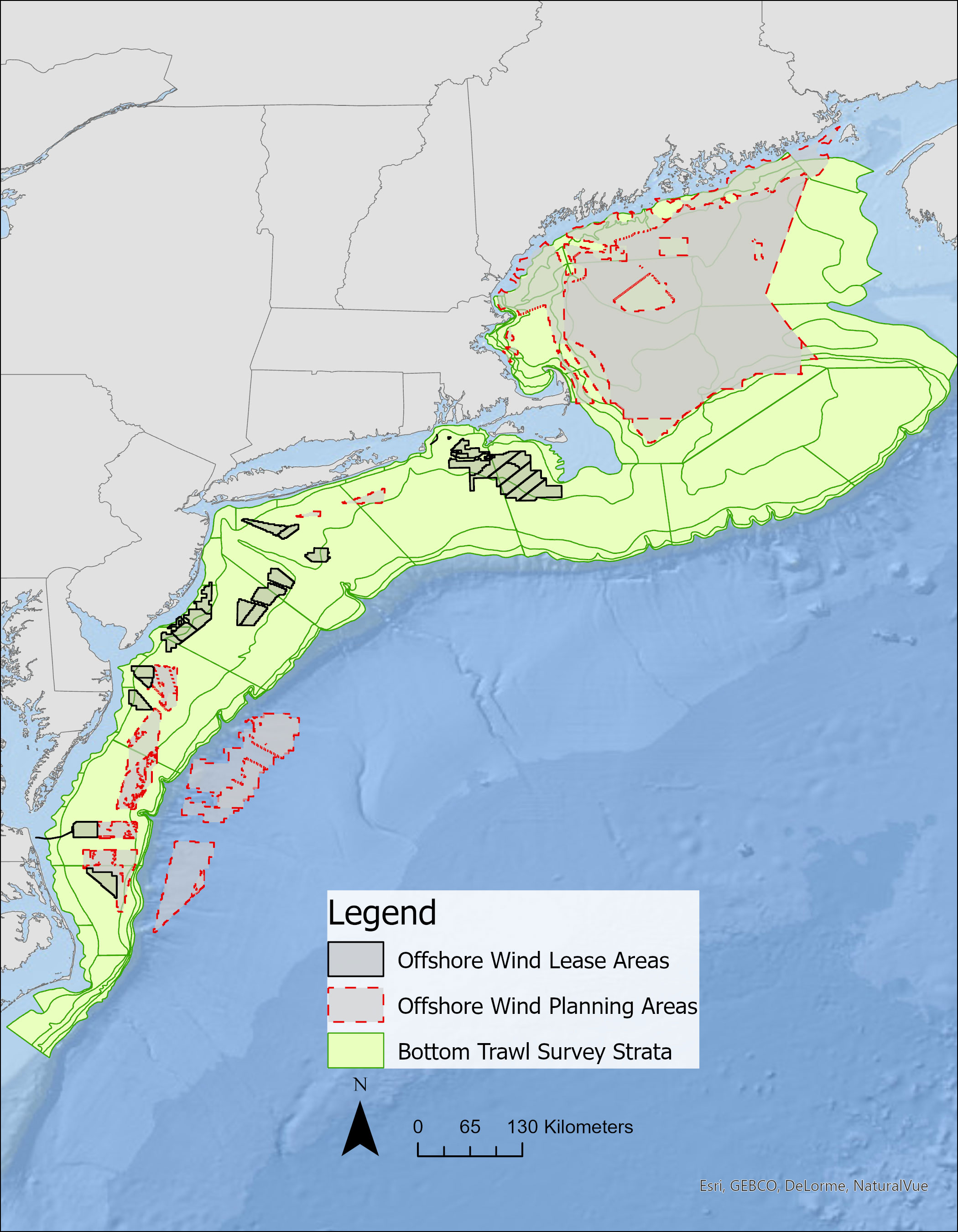
Figure 1 NOAA Fisheries fall and spring Bottom Trawl Survey strata overlaid by current offshore wind leases and planning areas in the NES ecosystem. Planning areas are initial areas identified by BOEM as potentially suitable for wind development. These areas are winnowed down through analysis and input from stakeholders to wind energy areas (WEAs). Lease areas are specific areas of the WEAs that are leased to developers for wind project development. Map provided by Angela Silva (NOAA Fisheries).
Table 1 NOAA Fisheries scientific surveys.
Because of the substantial spatial overlap between offshore wind development and NOAA Fisheries scientific surveys (e.g., Bottom Trawl Survey, Figure 1), wind development will impact the surveys through the following four means (Hare et al., 2022): 1) Preclusion - displacement of survey by wind infrastructure; 2) Impacts to Statistical Survey Design - current statistical survey methods will no longer be able to be executed due to reduced spatial sampling frame; 3) Change in Habitat and Concomitant Effects on Population Structure - changes in habitat will have affect species distribution, abundance, and vital population rates both inside and outside of wind project areas and lead to changes in population structure after construction and for the lifetime of the project; and 4) Practical Sampling - navigating survey vessels around wind energy areas will increase transit time and sampling time. In the immediate term, these impacts will cause gaps in long term time series of the surveys. The long term implications of survey impacts and the knock-on effect of reduced data quality to support stock assessment and management advice, will ultimately lead to greater uncertainty in fisheries management. Given the severity of the impacts that wind development will have on NOAA Fisheries scientific surveys, NOAA Fisheries and the Bureau of Ocean Energy Management (BOEM) have joined together to establish the Federal Survey Mitigation Strategy for Northeast U.S. Region (Hare et al., 2022). The Mitigation Strategy is intended to guide the Mitigation Program which will include survey-specific mitigation plans for each impacted survey, including both vessel and aerial surveys (Survey-Specific Mitigation Plans). Although specific to the Northeast U.S. Region (Maine to North Carolina), the strategy is generally applicable to other regions of the country. These issues are also being faced in many other counties and they are currently being addressed by the International Council for the Exploration of the Seas (ICES) Working Group for Offshore Wind and Fisheries (ICES, 2022) and have been incorporated into the objectives of the ICES roadmap for Offshore and Marine Renewable Energy (ICES, 2023).
A potential source of information that could mitigate impacts to NOAA Fisheries scientific surveys, evaluate population-level impacts, and inform our understanding of how stocks respond to habitat alteration is the project-level monitoring undertaken by wind developers. Project-level monitoring could be designed to address questions about changes in habitat, the underlying mechanisms, and how measured responses do or do not confer population level effects. For each wind project, some individual states require wind developers to conceive and execute project-level monitoring that evaluates the impacts derived from the construction, installation, and operation of wind structures (e.g., Vineyard Wind, 2023). BOEM also provides a set of guidelines for project monitoring and incorporates any of the state-level requirements or voluntary activities proposed by a developer into the project’s regulatory approval (BOEM, 2023).
The potential impacts on habitat and fisheries resources are substantial and include effects from a wide array of impact producing factors (IPFs) including electromagnetic fields (EMF), noise, benthic habitat alteration, artificial reef and FAD effects, pelagic habitat alteration, and hydrodynamic changes (NOAA, 2023). Each of these IPFs cause habitat alterations that have the potential to affect vital population rates and thus populations. Despite the requirements to conduct project-level monitoring, there currently exist no requirements for what a monitoring plan should contain, although various sets of guidelines have been provided by BOEM, state agencies, and regional working groups (MADMF, 2018; ROSA, 2021; BOEM, 2023). The collection of monitoring data in and around individual wind projects represents a potential opportunity to mitigate impacts to NOAA Fisheries scientific surveys. These data could inform our understanding of impacts to populations and provide data that could supplement information lost from the survey time series due to wind development. This opportunity was recognized by the Federal Survey Mitigation Strategy which called for an evaluation and integration, where feasible, of wind energy development monitoring studies with NOAA Fisheries surveys (Hare et al., 2022, Action 2.2.1).
The purpose of this paper is to evaluate whether project-level monitoring studies as currently designed by wind developers will mitigate impacts to the long-term scientific resource surveys conducted by NOAA Fisheries with a focus on fisheries resource surveys. Specifically, we evaluated whether they can yield information that can fill expected gaps in long term surveys, examine impacts at the population level, and/or inform our understanding of how populations will respond to wind-derived habitat alterations. To that end, we 1) Collated all existing offshore wind development fisheries and benthic monitoring plans and tabulated several key aspects of each plan; 2) Determined whether each survey proposed by project-level monitoring collects information that is functionally equivalent to the comparable NOAA Fisheries scientific survey; and 3) Provide recommendations on how project-level monitoring plans could be adapted to enhance their suitability for providing information that can support existing scientific survey time series and thus the mitigation of wind-derived impacts on fisheries management. For clarity, we use the term “monitoring plan” throughout this paper to refer to the combined benthic and fisheries monitoring plan for an individual wind project. The term “study” is used to refer to a specific experiment within a monitoring plan. The term “survey” is used to refer to NOAA Fisheries scientific surveys.
Methods
All accessible fisheries and benthic monitoring plans were gathered and collated. The plans are publicly available and can be accessed on websites maintained by BOEM, other agencies, or obtained directly from the developers. From each monitoring plan, we extracted and compiled the following information into a table:
Characteristics of the monitoring studies
These included: 1) Name of the wind project; 2) Stated research question or hypothesis; 3) Impact producing factors studied; 4) Target taxa, species, or habitat; 5) Gear type; 6) Location; 7) Data types to be collected; 8) Where the study will be conducted (e.g., wind project, controls, cable route); 9) Month and/or Season of sampling; 10) Temporal duration during each phase of wind development; 11) Experimental design; 12) Statistical method for station selection (e.g., random, systematic, etc.); 13) Regional survey the plan states that it is comparable to or is modeled after, if any; and 14) Comparable NOAA Fisheries scientific survey, i.e., survey that is currently sampling the same species or habitat as the proposed monitoring; and 15) Description of how QA/QC’d data will be accessible and readily available.
Utility of the monitoring plan in mitigating wind-derived impacts to long-term surveys
We further examined whether the monitoring studies as proposed: 16) Include supplementing the comparable NOAA Fisheries survey as stated an objective; 17) Are calibrated to an existing NOAA Fisheries survey; 18) Address Preclusion; 19) Address impacts to statistical survey design; 20) Address habitat change and responses to habitat change after construction and for the lifetime of the wind project; 21) Address practical sampling issues; and 22) Provide a functionally equivalent sample to the comparable NOAA Fisheries survey.
Results
We identified monitoring plans from 9 different offshore wind projects that were available for review including: Atlantic Shores (2021a; 2021b); Empire Wind (2022); New England Wind (2021a; 2021b); Ocean Wind (2021; 2022); Revolution Wind (2021); South Fork Wind (2020); Sunrise Wind (2021); Vineyard Wind (2023), and Coastal Virginia Offshore Wind (CVOW, 2022a; CVOW, 2022b). Thus 27% of the N=33 total leased areas in the NES ecosystem (BOEM, 2023) have proposed fisheries and benthic monitoring plans that were accessible. Among these, there were 67 unique monitoring studies proposed across a range of taxonomic groups and habitat types (Supplemental Tables S1-S5).
Characteristics of the monitoring studies
Research question, objective, or hypotheses and IPFs evaluated
All of the proposed studies provided research questions, objectives, and/or hypotheses that were to be addressed (Figure 2; Supplemental Table S1). A small proportion of studies proposed to explore a specific IPF. All of these were local scale studies that did not explore potential impacts to populations-level impacts at the spatial scale of the stock. Among the 67 studies were 6 (9%) studies aimed at studying how physical disturbance during the cable installation process affected benthic habitat and/or benthic habitat function. Also, two (3%) studies specifically planned to test hypotheses related to electro-magnetic frequency (EMF) impacts along cables although one of these had a hypothesis that combined the effects of both physical disturbance and EMF. One other study planned to look at the effect of boulder relocation on the epibenthic community. The vast majority of studies (n=60; 90%) focused on the overall impact of wind project structures (presence vs. absence) on target species that are expected to occur in the area.
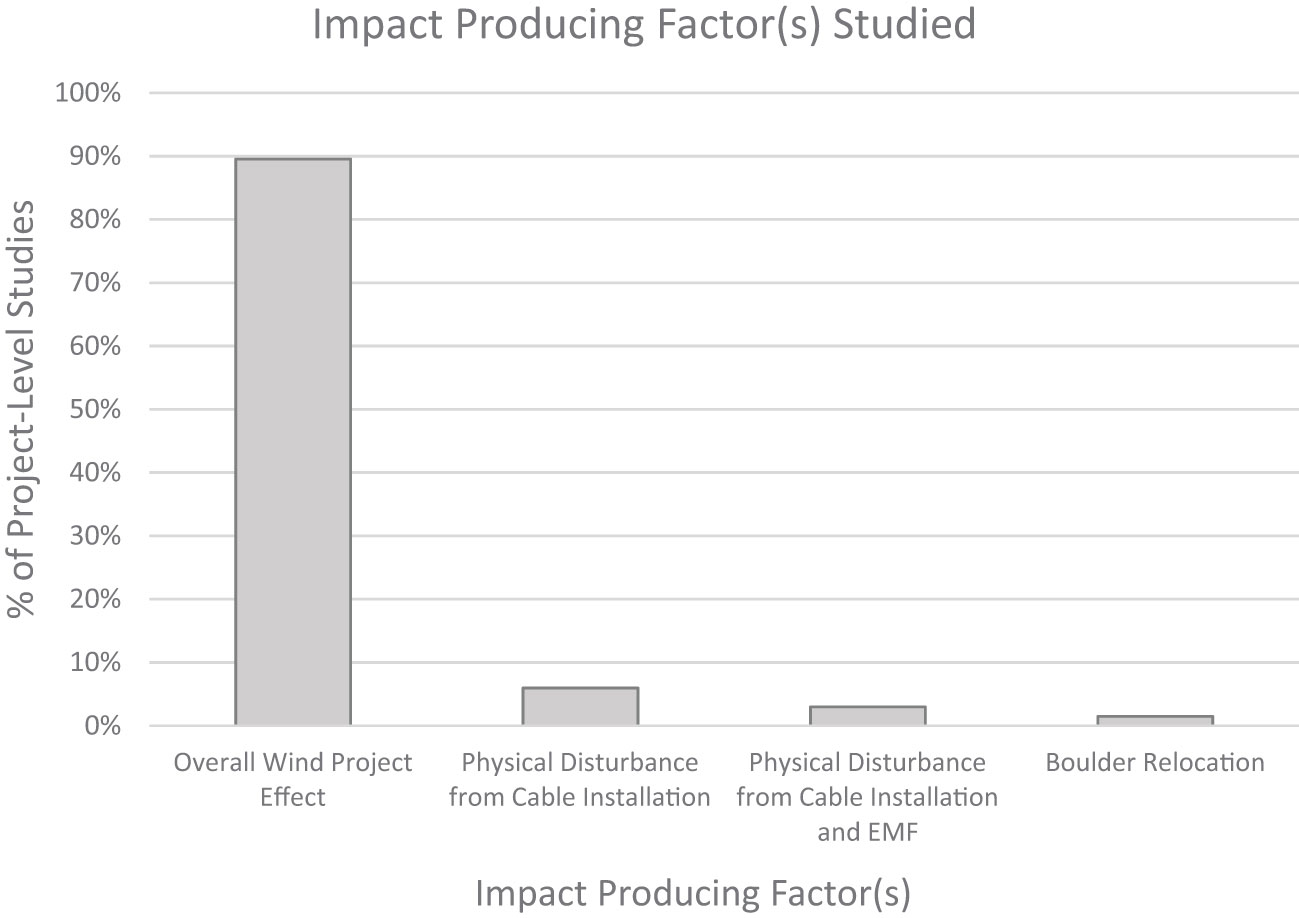
Figure 2 The proportion of project level studies (N=67) that studied particular effects or impact producing factors (IPFs).
Study target and sampling gear
Eight (89%) of the N=9 wind project monitoring projects included a trawl study (e.g., otter trawl, beam trawl) to investigate demersal fish and invertebrates, representing 12% of the N=67 overall proposed studies (Figures 3A, B; Supplemental Table S2). There were 2 (22%) wind projects (Ocean Wind 1 and Atlantic Shores) that proposed dredge studies to examine surf clams and other shellfish, representing 3% of all studies proposed. A total of 11 (16%) studies across 7 (78%) wind projects proposed to utilize fish pots or traps to study structure associated species including black sea bass (Centropristis striata), tautog, scup, American lobster (Homarus americanus), Jonah crab (Cancer borealis), and whelk (Busycon spp.). A total of 17 (25%) studies plan optical sampling modalities. This included 9 (13%) studies across 6 (67%) wind projects that plan to use remotely operated vehicle (ROV)/video studies of hard bottom habitat; 2 (3%) studies across 2 (22%) wind projects that plan to use ROV/video to study benthic megafauna or epibenthos; 2 (3%) studies across 2 (22%) wind projects that plan to use drop camera methods to examine benthic macrofauna; 1 (2%) study at a single wind project that plans to use drop camera methods to study submerged aquatic vegetation (SAV) coverage; 3 (4%) studies across 2 wind projects (22%) that plan to use baited remote underwater video (BRUV) methods to study structure-oriented or large pelagic fish; and 1 (2%) plan view camera study of scallops at a single wind project. Eight (12%) acoustic telemetry studies across 6 (67%) wind projects were proposed that targeted highly migratory species, lobsters, elasmobranchs, and other demersal finfish such as summer flounder and black sea bass. All acoustic telemetry studies involved fixed receiver arrays but two also included data collected from an autonomous glider. Sediment profile imaging/Plan View camera methods (SPI/PV) were the most common method for studying soft bottom habitat function (11 (67%) studies across 5 (56%) wind projects) including within the array and along the cable route. Only 2 (3%) of these studies planned to also collect physical sediment samples with a grab. Neuston nets will be used to sample lobster larvae and other planktonic organisms in 2 (22%) wind projects. The non-extractive method of eDNA sampling is planned for 2 (22%) wind projects. Gillnet, the least common method proposed for studying the demersal fish community, was planned for 1 wind project.
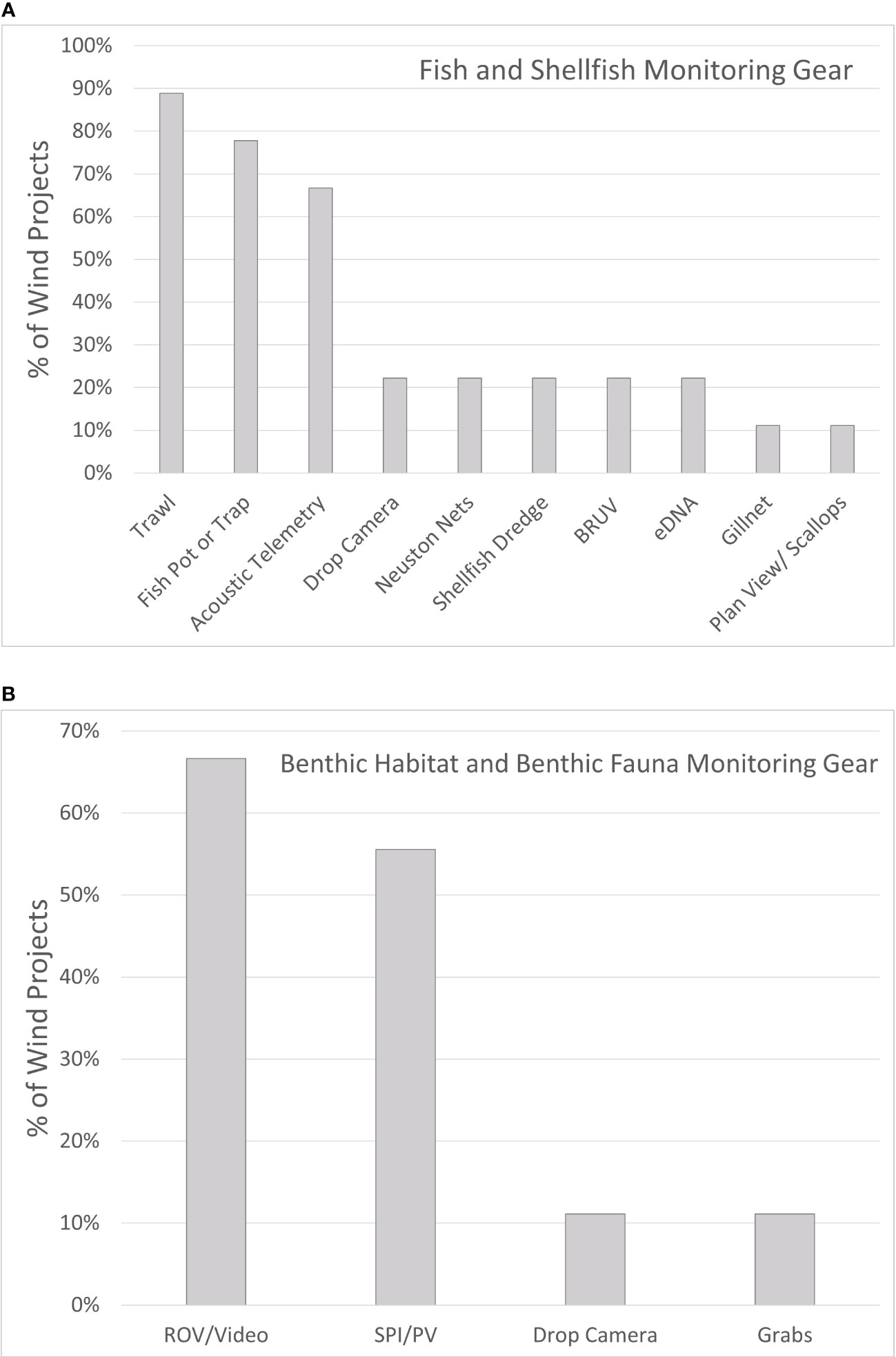
Figure 3 Gear types used. The proportion of wind projects (N=9) that used each of the gear types proposed to examine (A) Fish and shellfish and (B) Benthic habitat and/or benthic fauna.
Location
Of the N=67 studies, there were 7 (10%) studies proposed along wind project export cables and 1 (2%) study proposed along the inter-array cable (Supplemental Table S2). The remaining 59 (88%) studies focused on structures within the footprint of the wind project; 30 (45%) included comparisons with controls located outside of the wind energy area. Some telemetry projects noted that existing arrays located outside of the wind project array would supplement their study (e.g., Bangley et al., 2020).
Data types to be collected
Abundance, community composition, length, weight, and reproductive status were the most common types of data planned for collection for finfish while less common were diversity, species richness, and diet composition of specific species (Supplemental Table S3). Studies of lobsters frequently planned collect data on carapace length, sex, egg status, v-notch status, cull status, and shell disease incidence. For Jonah crab collecting data on carapace width, ovigery, sex, shell disease incidence, cull status, and mortality data were common objectives. Hard bottom habitat monitoring planned to focus on measures of %cover; relative abundance of microbiota; estimated biomass/biovolume; invasive species. Studies employing acoustic telemetry aimed to collect data to characterize presence, residency, movement, and in some instances connectivity among lease areas. Dredge studies of shellfish focused on biomass, volume, size, and age measurement.
Month or season of sampling
The month or season of sampling varied among monitoring plan goals and target species (Supplemental Table S3). Most studies of fisheries resource species aimed to collect data when species were expected to be present and/or when commercial fisheries for the target species were most active. Several plans noted that particular months would be avoided to minimize interactions with protected species.
Temporal Duration. Of the N=67 studies proposed, 11 (16%) planned only a single year of baseline data collection (Figure 4; Supplemental Table S3). Twenty-two (33%) planned 2 years of baseline data collection, 25 (37%) planned baseline data collection for an unspecified number of years. The remaining 9 studies were only planned for the post construction time period.
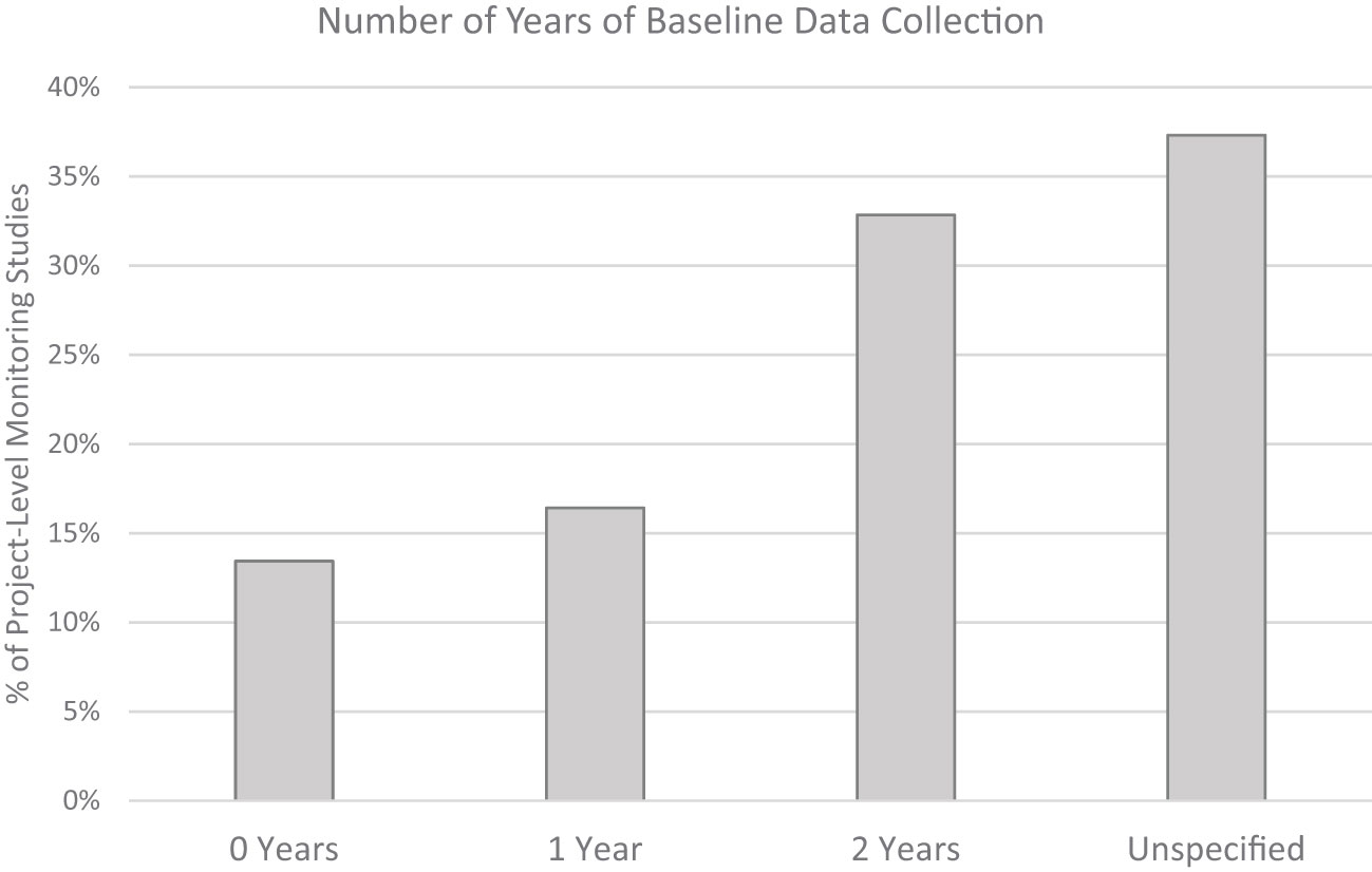
Figure 4 Baseline data collection. The proportion of project monitoring studies (N=67) proposing 0, 1, 2, or an unspecified number of years of baseline data collection.
Experimental design
Twenty-six (39%) of N=67 proposed studies proposed a before-after-control-impact (BACI) design, 21 (31%) planned a before-after-gradient (BAG) design, and 4 (6%) planned a hybrid BACI/BAG approach (Supplemental Table S3) (Methratta, 2020). Six (9%) proposed a Before-After study in the impact area with no control. Seven (10%) proposed a post-construction study only in the impact area with no control. There were 3 (4%) proposed studies that did not have a clear experimental design stated or implied.
Statistical method for station selection
Random selection was the most common method for station assignment (Supplemental Table S3). Several studies sought to achieve a spatial balance by spatially gridding the study area and randomly selecting a station within each grid cell. Systematic random sampling was another method used to avoid areas with set fishing gear. Stratification by habitat type was applied in some instances to address spatial variability.
Comparability with regional assessments
Twenty-three (34%) of N=67 studies noted that they were using methods consistent with another regional or state survey (Supplemental Table S3). For example, trawl studies consistently noted that they would follow the protocols of Northeast Area Monitoring and Assessment Program (NEAMAP) while optical studies of sea scallops and other shellfish noted that their study was similar to other regional drop camera or HABCam studies (Bonzek et al., 2017; Bethoney and Stokesbury, 2018; Coonamessett Farm, 2023). Another 11 (16%) noted that they were using similar methods to those applied in another lease area. The one study that planned to use a gillnet specifically noted that their results would not be comparable to other regional datasets due differences in catchability.
Comparable NOAA Fisheries scientific survey
Of the 44 studies targeting fisheries species, 36 (82%) have spatial and temporal overlap with a comparable existing NOAA Fisheries scientific surveys (Supplemental Table S4). Because the focus of the studies is on comparing impacts within project areas, the majority do not employ methods that provide comparable measurements to the NOAA Fisheries surveys (Supplemental Table S4).
Provides for QA/QC’d data to be accessible and readily available
The majority of studies presented no plan to share or make accessible the QA/QC’d raw data collected in the study (Supplemental Table S3). The one exception were acoustic telemetry studies, most of which planned to share data with other telemetry researchers on the ACT and/or MATOS networks (Atlantic Cooperative Telemetry network, Mid-Atlantic Acoustic Telemetry Observation System).
Utility of the monitoring plan in mitigating wind-derived impacts to long-term surveys
Includes supplementing the NOAA Fisheries survey as a stated objective
None of the proposed studies stated that supplementing NOAA Fisheries scientific surveys was one of their objectives (Supplemental Table S4).
Will be calibrated to an existing NOAA Fisheries survey
None of the proposed studies indicated that the study would be calibrated with an existing NOAA Fisheries scientific survey (Supplemental Table S4).
Addresses preclusion
None of the proposed studies indicated that the study would address the issue of sampling preclusion of the comparable NOAA Fisheries scientific survey within the wind project (Supplemental Table S5). Studies that describe the use of gear and methods consistent with regional protocols, such as trawl studies that state that Northeast Ecosystem Assessment and Monitoring Program (NEAMAP) methods are employed, lack specificity of how the study design employs these standards, e.g. gear and vessel configuration; fish diet and condition methods; and relative to NOAA Fisheries multi-species groundfish survey, none of the proposed studies include sampling at night which contrasts with federal trawl survey protocols.
Addresses impacts to statistical survey design
None of the proposed studies indicated that the study would address issues with the statistical survey design of the comparable NOAA Fisheries scientific survey within the wind project (Supplemental Table S5).
Addresses habitat change and responses to habitat change
All (100%) of the 67 proposed studies intended to address either habitat change or a biological response to habitat change caused by wind development (Supplemental Tables S1-S3; S5). However, study design issues reduce the likelihood that these studies will be able to address this question. These issues include insufficient baseline study duration (most proposed 0, 1, or 2 years), experimental designs that utilize a control that is likely within the zone of impacts, and unknown statistical power for most of the variables mentioned (although some studies conducted power analyses for measures of abundance). In addition, no studies indicated how the local-scale investigations proposed might inform impacts of wind development for the lifetime of the wind project or at the population level of the species studied.
Addresses practical sampling issues
None of the proposed studies indicated that they would address practical sampling issues (e.g., increased transit time) due to wind development (Supplemental Table S5).
Provides a functionally equivalent sample to the comparable NOAA Fisheries survey
The 2 (3%) drop camera studies proposed to study benthic habitat and macroinvertebrate abundance and distribution have the potential to provide a sample that is functionally equivalent to the comparable NOAA Fisheries survey (Supplemental Table S5). The remaining 65 (97%) studies will not be able to do so.
Discussion/conclusions
Project-level monitoring for offshore wind projects as currently designed for the NES ecosystem will not yield information that can be integrated into NOAA Fisheries scientific survey time series, nor are they designed with that intention. Therefore, they cannot help to mitigate scientific survey impacts from offshore wind development. In order for data yielded by project-level studies to be used in stock assessments, samples would need to be functionally equivalent to those collected by the NOAA Fisheries survey of the same population. Achieving functional equivalency for any of the surveys would be challenging and time intensive, often taking 10+ years of comparison of the datasets (Miller et al., 2010; ASMFC, 2020). For example, bottom trawl sampling was proposed for nearly every offshore wind project. In every instance, the plans noted that some or all of the protocols of the Northeast Area Monitoring and Assessment Program (NEAMAP) would be followed. Typically the studies emphasized matching such elements as gear type (demersal otter trawl), net mesh size, gear deployment and haul protocol, and sample handling with those of NEAMAP. Although this is laudable from the perspective of maintaining regional consistency among wind projects, unfortunately it does not ensure functional equivalency with the NOAA Fisheries bottom trawl survey, which means that those data cannot be automatically incorporated into stock assessment models. The same challenge is faced by nearly all of the project-level monitoring studies that are targeting species that are also sampled by NOAA Fisheries surveys.
An exception may be the drop camera studies used to evaluate abundance and other indices for sea scallops (Bethoney and Stokesbury, 2018). This study methodology employs a systematic grid design with samples collected at regular spatial intervals that are at equal distances from each other. Originally designed by the University of Massachusetts School of Marine Science and Technology (SMAST) in collaboration with commercial scallop fishermen, information collected by the SMAST survey has been incorporated into scallop stock assessment through the Stock Assessment Workshop process) (e.g., NEFSC, 2018).
The provision of scientific advice to inform fisheries management decisions is underpinned by population assessments developed with acceptable levels of accuracy and precision. The fisheries independent data collections undertaken by NOAA Fisheries each year provide unbiased data that are used in the calculation of biological indices for stock assessment purposes. The tremendous strength of NOAA Fisheries scientific surveys is rooted in their long-term spatial and temporal consistency in method and execution which includes rigorous statistical survey designs that are individualized for the taxa, species, or habitats that they are designed to sample. The development of offshore wind will disrupt the collection of data for every NOAA Fisheries survey and will thus create spatial and temporal gaps in every data set it collects. Fishery independent surveys are designed to provide essential, unbiased data for stock assessments, including indices of abundance, size and age composition, growth rates, and additional life history parameters (Lynch et al., 2018). Loss of accessible areas will have the knock-on effect of introducing bias into the assessments, with the potential for an index to deviate from the true trend if a species does not have a uniform distribution across the entire area. For example, structure-oriented species attracted to offshore developments may become unavailable to the survey. This would cause the index of abundance to artificially decrease, with the stock appearing to decline in the assessment. Some species also exhibit age-specific habitat preference (Macpherson and Duarte, 1991; Swain, 1993; Methratta and Link, 2007; Pappal et al., 2012), with individuals moving shallower or becoming less structure-oriented as they grow. The potential exists for an assessment to interpret the absence of certain ages as age-specific mortality, which could be attributed to recruitment failure or age truncation. This will also have a direct impact on many forms of Biological Reference Point (BRP), which is a measure of stock status that reflects the combination of several components of stock dynamics (growth, recruitment and mortality, fishing mortality) into a single index. The severity of these impacts on the accurate, timely, and precise assessments of stock condition will vary by stock due to specified stock assessment methods and their sensitivity to changes in sampling methods and potential interactions of offshore wind impact producing factors on stock attributes. However, identifying approaches that could potentially fill these gaps is essential to being able to provide fisheries managers with valid scientific advice. So what potential solutions might be considered?
For some population assessments, it may still be necessary to physically sample inside of wind projects to collect the necessary data, including for stocks where there is a likelihood that variance structure inside wind energy development areas may differ from outside of wind energy areas (e.g., Reubens et al., 2013; Roach et al., 2022). Given the amount of time to evaluate functional equivalency, it would be prudent to initiate a process by which samples that are functionally equivalent to long term surveys could be collected (e.g., Miller et al., 2010; ASMFC, 2020). In addition to deriving estimates of abundance, NOAA Fisheries surveys collect biological samples to provide essential data on population growth, reproduction, and age structure, among other information (e.g., bottom trawl survey, Azarorvitz et al., 1981). To provide relevant data, study design within a project should aim to supplement the existing NOAA Fisheries surveys for all data types, not only provide a replacement abundance value for stations precluded by the development of the project. It will be essential to monitor growth and reproductive rates of structure-oriented species, such as black sea bass (Bacheler and Ballenger, 2016), for the life of the project as these vital population rates may differ significantly between habitats.
For other populations, estimation modeling methods may provide an alternative approach to developing biological indices in areas that cannot be sampled by existing long term surveys (e.g., Thorson et al., 2019). Applying such methods with a high level of statistical validity and reliability would require making a set of assumptions about how populations respond to habitat change in the zone of impact of wind development compared to areas outside the zone of impact, how these changes vary over space, and how these patterns change through time. Project-level monitoring aimed at validating these assumptions, could provide a path toward understanding regional changes in population status.
The vast majority of project-level monitoring studies aim to address one fundamental question: what effect will offshore wind development have on response metrics of a target species? Successfully addressing this question is an essential part of being able to validate the assumptions regarding how populations respond to wind-derived habitat change. Whether or not this question can be answered by the studies proposed will depend on whether sufficient baseline data are collected, whether a suitable experimental design and methodology are planned, and whether the study possesses sufficient statistical power to detect a change. The NES ecosystem is a dynamic system under multiple pressures including climate change and fishing (Nye et al., 2009; Hare et al., 2016). Given underlying trends, the ability to distinguish offshore wind impacts from existing patterns of variability will require a robust understanding of baseline conditions. In order to evaluate inter-annual variability in the baseline state, at least 3-5 years of data would be needed which is greater than the 0-2 years proposed by most studies. Three to five years may still not be sufficient to adequately assess baseline temporal variability (e.g., Willsteed et al., 2018a; Willsteed et al., 2018b), but would provide a minimal view of the temporal sampling distribution. Post construction study duration is another key element of study design given that the longest running studies from European wind energy areas have reported new and significant effects more than 9 years since operations began (e.g., Buyse et al., 2022; Degraer et al., 2021). In the U.S., Wilber et al. (2022) reported an increase in structure oriented species such as Atlantic cod (Gadus morhua) and black sea bass following installation, but understanding how these effects change over time and whether these impacts convey population-level effects will require studies that span the lifetime for the wind project. Studies employing control sites are also vexed by the challenge of finding control sites that have sufficiently similar habitat conditions as the impact site but are outside the potential zone impacts of wind development which may extend 10s-100s of km (Popper and Hawkins, 2019; Christiansen et al., 2022; Daewel et al., 2022). Power analysis was a common tool employed in the study design to assess the number of samples needed to detect a change; typically power is only analyzed for measures of abundance so it remains uncertain whether the sample size chosen will be sufficient to detect changes in other metrics important in describing fisheries resource populations. Many of the proposed studies would require some modification to reduce the uncertainty in their ability to detect changes caused by wind development.
Toward mitigating the impacts of offshore wind development on long term scientific surveys, we make the following recommendations: 1) Advance the actions outlined in the BOEM and NOAA Survey Mitigation Strategy which includes evaluating how project-level monitoring may contribute to mitigating impacts to long term scientific surveys and developing regional monitoring standards (Hare et al., 2022); 2) Coordinate with scientists at NOAA Fisheries early on when developing monitoring plans to discuss methodologies and best practices; 3) For each study, clarify whether the study is designed to address project-level changes (local variation) and whether they are designed to collect functionally equivalent samples (abundance and biological) to ensure proper management of fishery resources at the population level; 4) Align sampling methodologies with studies within the region studying the same target taxa, species, or habitat (e.g., sampling gear; sampling protocols; handling of samples; measurements made, etc.); 5) Extend the temporal sampling frame to at least 3-5 years of baseline data; after construction, conduct sampling for the lifetime of the project; 6) Design experiments that can provide information that informs our understanding of how populations respond to habitat change caused by wind development and that can validate the assumptions of estimation models for biological indices for areas that will no longer be sampled by NOAA Fisheries surveys; and 7) Provide ready access to raw QA/QC’d data files. These recommendations are applicable in the U.S. and are also relevant in other countries where similar issues are occurring.
Author contributions
AL and ETM contributed to the concept and layout of the paper. ETM wrote the first draft of the paper. AL, JMB, and ETM wrote text and reviewed for accuracy. All authors contributed to the article and approved the submitted version.
Acknowledgments
We are grateful to our colleagues at the Northeast Fisheries Science Center (NEFSC) for many discussions on offshore wind topics. We thank Peter Chase and Jon Hare at NEFSC for providing constructive comments that improved this manuscript.
Conflict of interest
The authors declare that the research was conducted in the absence of any commercial or financial relationships that could be construed as a potential conflict of interest.
Publisher’s note
All claims expressed in this article are solely those of the authors and do not necessarily represent those of their affiliated organizations, or those of the publisher, the editors and the reviewers. Any product that may be evaluated in this article, or claim that may be made by its manufacturer, is not guaranteed or endorsed by the publisher.
Author disclaimer
The views expressed herein are those of the authors and do not necessarily reflect the views of the Department of Commerce or its sub-agencies.
Supplementary material
The Supplementary Material for this article can be found online at: https://www.frontiersin.org/articles/10.3389/fmars.2023.1214949/full#supplementary-material
References
ASMFC (2020) 2020 American shad benchmark stock assessment and peer review report (Arlington, VA). Available at: https://asmfc.org/uploads/file/63d8437dAmShadBenchmarkStockAssessment_PeerReviewReport_2020_web.pdf (Accessed April 24, 2023).
Atlantic Shores (2021a). Atlantic Shores benthic monitoring plan. Atlantic Shores Offshore Wind Construction and Operations Plan for Commercial Lease OCS (OCS-A 0499), Appendix II-H, (Atlantic Shores Offshore Wind, Atlantic City, NJ). 29. Available at: https://www.boem.gov/renewable-energy/state-activities/atlantic-shores-offshore-wind-construction-and-operations-plan. (Accessed June 21, 2023).
Atlantic Shores (2021b). Atlantic Shores fisheries monitoring plan. Atlantic Shores Offshore Wind Construction and Operations Plan for Commercial Lease OCS (OCS-A 0499), Appendix II-K, (Atlantic Shores Offshore Wind, Atlantic City, NJ), 76. Available at: https://www.boem.gov/renewable-energy/state-activities/atlantic-shores-offshore-wind-construction-and-operations-plan. (Accessed on June 21, 2023).
Azarovitz T. R. (1981). A brief historical review of the Woods Hole Laboratory trawl survey time series. Canadian Special Publication in Fisheries and Aquatic Sciences 58, 62–67.
Bacheler N. M., Ballenger J. C. (2016). Spatial and temporal patterns of black sea bass sizes and catches in the Southeastern United States inferred from spatially explicit nonlinear models. Mar. Coast. Fisheries: Dynamics Management Ecosystem Sci. 7, 523–536. doi: 10.1080/19425120.2015.1095826
Bangley C. W., Whoriskey F. G., Young J. M., Ogburn M. B. (2020). Networked animal telemetry in the Northwest Atlantic and Caribbean waters. Mar. Coast. Fisheries 12, 339–347. doi: 10.1002/mcf2.10128
Bethoney N. D., Stokesbury K. D. (2018). Methods for image-based surveys of benthic macroinvertebrates and their habitat exemplified by the drop camera survey for the Atlantic Sea scallop. J. Vis. Exp. 137), e57493. doi: doi: 10.3791/57493
Bonzek C. F., Gartland J., Gauthier D. J., Latour R. J. (2017). Northeast area monitoring and assessment program (NEAMAP) 2016 data collection and analysis in support of single and multispecies stock assessments in the mid-Atlantic: northeast area monitoring and assessment program near shore trawl survey (Williamsburg, VA: Virginia Institute of Marine Science, William & Mary). doi: 10.25773/7206-KM61
Bureau of Ocean Energy Management (2023)Fishery survey guidelines. Available at: https://www.boem.gov/sites/default/files/documents/about-boem/Fishery-Survey-Guidelines.pdf (Accessed April 16, 2023).
Buyse J., Hostens K., Degraer S., De Backer A. (2022). Offshore wind farms affect the spatial distribution pattern of plaice pleuronectes platessa at both the turbine and wind farm scale. ICES J. Mar. Sci. 0, 1–10. doi: 10.1093/icesjms/fsac107
Christiansen N., Daewel U., Djath B., Schrum C. (2022). Emergence of large-scale hydrodynamic structures due to atmospheric offshore wind farm wakes. Front. Mar. Sci. 9. doi: 10.3389/fmars.2022.818501
Coonamessett Farm (2023). Available at: https://www.coonamessettfarmfoundation.org/habcam-surveys (Accessed April 16, 2023).
CVOW (2022a). Fishery characterization and resource monitoring for black Sea bass (Centropristis striata.) at the coastal Virginia offshore wind (CVOW) development site (Williamsburg, VA: Virginia Institute of Marine Science), 13.
CVOW (2022b). Fishery characterization and resource monitoring for whelk (Busycon spp.) at the coastal Virginia offshore wind (CVOW) development site (Williamsburg, VA: Virginia Institute of Marine Science), 15.
Daewel U., Akhtar N., Christiansen N., Schrum C. (2022). Offshore wind farms are projected to impact primary production and bottom water deoxygenation in the North Sea. Commun. Earth Environ. 3, 292. doi: 10.1038/s43247-022-00625-0
Degraer S., Brabant R., Rumes B., Vigin L. (2021). “Environmental impacts of offshore wind farms in the Belgian part of the North Sea: attraction, avoidance, and habitat use at various spatial scales,” in Memoirs of the marine environment (Brussels: Royal Belgian Institute of Natural Sciences, OD Natural Environment, Marine Ecology and Management), 104.
Empire Wind (2022). Empire wind fisheries and benthic monitoring plan. (Stamford, CT: Empire Wind, LLC), 108. Available at: https://www.empirewind.com/environment-and-sustainability/mariners-and-fisheries/. (Accessed June 21, 2023).
Hare J. A., Blyth B. J., Ford K. H., Hooker B. R., Jensen B. M., Lipsky A., et al. (2022) NOAA Fisheries and BOEM federal survey mitigation implementation strategy -northeast U.S. region. NOAA technical memorandum 292 (Woods Hole, MA). Available at: https://www.fisheries.noaa.gov/resource/document/federal-survey-mitigation-strategy-northeast-us-region (Accessed April 16, 2023).
Hare J. A., Morrison W. E., Nelson M. W., Stachura M. M., Teeters E. J., Griffis R. B., et al. (2016). A vulnerability assessment of fish and invertebrates to climate change on the northeast U.S. continental shelf. PloS One 11 (2), e0146756. doi: 10.1371/journal.pone.0146756
ICES (2022). Working Group on Offshore Wind Development and Fisheries (WGOWDF). ICES Scientific Reports. 4:98. (Copenhagen: International Council for the Exploration of the Sea). 18. doi: 10.17895/ices.pub.21750458
ICES (2023). Workshop on a Research Roadmap for Offshore and Marine Renewable Energy (WKOMRE). ICES Scientific Reports. 5:56. (Copenhagen: International Council for the Exploration of the Sea), 32. doi: 10.17895/ices.pub.23097404
Lynch P. D., Methot R. D., Link J. S. (2018). Implementing a next generation stock assessment enterprise. an update to the NOAA fisheries stock assessment improvement plan (Silver Spring, MD: U.S. Dep. Commer., NOAA Tech), 127. doi: 10.7755/TMSPO.183
Macpherson E., Duarte C. M. (1991). Bathymetric trends in demersal fish size: is there a general relationship? Mar. Ecol. Prog. Ser. 71, 103–112. doi: 10.3354/meps071103
MADMF (2018)Management objectives and research priorities for fisheries in the Massachusetts and Rhode Island-Massachusetts offshore wind energy area. Available at: https://www.mass.gov/doc/management-objectives-and-research-priorities-for-offshore-wind-and-fisheries/download (Accessed April 26, 2022).
Methratta E. T. (2020). Monitoring fisheries resources at offshore wind farms: BACI vs. BAG designs. ICES J. Mar. Sci. 77, 890–900. doi: 10.1093/icesjms/fsaa026
Methratta E. T., Link J. S. (2007). Ontogenetic variation in habitat associations for four flatfish species in the gulf of Maine-georges bank region. J. fish Biol. 70 (6), 1669–1688. doi: 10.1111/j.1095-8649.2007.01428.x
Miller T. J., Das C., Politis P. J., Miller A. S., Lucey S. M., Legault C. M., et al. (2010). Estimation of albatross IV to Henry B. Bigelow calibration factors. northeast fish sci cent ref doc. 10-05 (166 Water Street, Woods Hole, MA: National Marine Fisheries Service), 233. Available at: http://www.nefsc.noaa.gov/nefsc/publications/.
New England Wind (2021a). New England wind draft benthic habitat monitoring plan, 25. (Monroe, MA: New England Wind Avangrid).
New England Wind (2021b). New England Wind fisheries monitoring plan. Construction and Operations Plan Appendix III-U. (Monroe, MA: New England Wind Avangrid), 42.
NOAA (2023) Fisheries and offshore wind interactions: synthesis of science. NOAA technical memorandum NMFS-NE-291 (Woods Hole, MA). Available at: https://repository.library.noaa.gov/view/noaa/49151 (Accessed April 16, 2023).
Nye J. A., Link J. S., Hare J. A., Overholtz W. J. (2009). Changing spatial distribution of fish stocks in relation to climate and population size on the northeast U.S. continental shelf. Mar. Ecol. Prog. Ser. 393, 111–129. doi: 10.3354/meps08220
Ocean Wind (2021). Ocean wind offshore wind farm fisheries monitoring plan. (Boston, MA: Ocean Wind - Orsted), 76.
Ocean Wind (2022). Ocean wind offshore wind farm benthic monitoring plan (Boston, MA: Ocean Wind - Orsted), 76.
Pappal A. L., Rountree R. A., MacDonald D. G. (2012). Relationship between body size and habitat complexity preference in age-0 and -1 year winter flounder Pseudopleuronectes americanus. J. Fish Biol. 81, 220–229. doi: 10.1111/j.1095-8649.2012.03328.x
Popper A. N., Hawkins A. D. (2019). An overview of fish bioacoustics and the impacts of anthropogenic sounds on fishes. J. Fish Biol. 94, 692–713. doi: 10.1111/jfb.13948
Reubens J. T., Braeckman U., Vanaverbeke J., Van Colen C., Degraer S., Vincx M. (2013). Aggregation at windmill artificial reefs: CPUE of Atlantic cod (Gadus morhua) and pouting (Trisopterus luscus) at different habitats in the Belgian part of the North Sea. Fisheries Res. 139, 28–34. doi: 10.1016/j.fishres.2012.10.011
Revolution Wind (2021). Revolution wind fisheries research and monitoring plan (Providence, RI: Revolution Wind, LLC and Inspire Environmental), 157. Available at: https://www.boem.gov/renewable-energy/state-activities/revolution-wind-farm-construction-and-operations-plan. (Accessed on June 22, 2023).
Roach M., Revill A., Johnson M. J. (2022). Co-Existence in practice: a collaborative study of the effects of the westermost rough offshore wind development on the size distribution and catch rates of a commercially important lobster (Homarus gammarus) population. ICES J. Mar. Sci. 79, 1175–1186. doi: 10.1093/icesjms/fsac040
ROSA (2021) ROSA offshore wind project monitoring framework and guidelines. Available at: https://www.rosascience.org/resources (Accessed June 29, 2022).
South Fork Wind (2020). South fork wind fisheries research and monitoring plan. (Amagansett, NY: South Fork Wind, LLC), 123. Available at: https://www.boem.gov/renewable-energy/state-activities/south-fork. (Accessed on June 22, 2023).
Sunrise Wind (2021). Sunrise wind fisheries and benthic research monitoring. (New York, NY: Sunrise Wind, LLC), 131. Construction and Operation Plan Appendix AA1.
Swain D. P. (1993). Age-and density-dependent bathymetric pattern of Atlantic cod (Gadus morhua) in the southern gulf of st. Lawrence. Can. J. Fisheries Aquat. Sci. 50 (6), 1255–1264. doi: 10.1139/f93-142
Thorson J. T., Adams G., Holsman K. (2019). Spatio-temporal models of intermediate complexity for ecosystem assessments: a new tool for spatial fisheries management. Fish Fisheries 20, 1083–1099. doi: 10.1111/faf.12398
Vineyard Wind (2023). Wind fisheries studies and science. Available at: https://www.vineyardwind.com/fisheries-science (Accessed April 29, 2023).
Wilber D. H., Brown L., Griffin M., DeCelles G. R., Carey D. A. (2022). Demersal and invertebrate catches relative to construction and operation of North America’s first offshore wind farm. ICES J. Mar. Sci. 79, 1274–1288. doi: 10.1093/icesjms/fsac051
Willsteed E. A., Birchenough S. N. R., Gill A. B., Jude S. (2018b). Structuring cumulative effects assessments to support regional and local marine management and planning obligations. Mar. Policy 98, 23–32. doi: 10.1016/j.marpol.2018.09.006
Keywords: renewable energy, survey mitigation, impact assessment, stock assessment, fisheries independent surveys
Citation: Methratta ET, Lipsky A and Boucher JM (2023) Offshore wind project-level monitoring in the Northeast U.S. continental shelf ecosystem: evaluating the potential to mitigate impacts to long-term scientific surveys. Front. Mar. Sci. 10:1214949. doi: 10.3389/fmars.2023.1214949
Received: 30 April 2023; Accepted: 15 June 2023;
Published: 06 July 2023.
Edited by:
Nathan Bacheler, Beaufort Laboratory, Southeast Fisheries Science Center (NOAA), United StatesReviewed by:
Josep Lloret, University of Girona, SpainBrendan J. Runde, The Nature Conservancy, United States
Copyright © 2023 Methratta, Lipsky and Boucher. This is an open-access article distributed under the terms of the Creative Commons Attribution License (CC BY). The use, distribution or reproduction in other forums is permitted, provided the original author(s) and the copyright owner(s) are credited and that the original publication in this journal is cited, in accordance with accepted academic practice. No use, distribution or reproduction is permitted which does not comply with these terms.
*Correspondence: Elizabeth T. Methratta, RWxpemFiZXRoLk1ldGhyYXR0YUBub2FhLmdvdg==