 Kasey Cantwell1*
 Amanda W. J. Demopoulos2
 Mitchell G. Hebner1
 Rachel Medley1Mark Mueller3
 Amanda N. Netburn1
- 1Office of Ocean Exploration and Research, National Oceanic and Atmospheric Administration, U.S., Silver Spring, MD, United States
- 2United States Geological Survey, Wetland and Aquatic Research Center, Gainesville, FL, United States
- 3Office of Environmental Programs, Bureau of Ocean Energy Management, Sterling, VA, United States
Initiated through Presidential direction and now codified, the National Ocean Mapping, Exploration, and Characterization (NOMEC) Council comprises leaders from U.S. federal agencies with a shared goal of mapping all waters of the United States and exploring and characterizing priority areas. The NOMEC Council’s two Interagency Working Groups, Ocean and Coastal Mapping (IWG-OCM) and Ocean Exploration and Characterization (IWG-OEC), both achieved major milestones recently with the 2023 release of the Draft Standard Ocean Mapping Protocols (SOMP) and the 2022 publication of the National Priorities for Ocean Exploration and Characterization. Building on this groundwork, the IWG-OEC is now looking to define and share best practices, guidelines, and resources for ocean exploration and characterization with the long-term goal of increasing community wide standardization to help achieve consistent common practices. First, the IWG-OEC plans to compile federal agency resources and share them in a newly developed online resource repository. The next phase is for the IWG-OEC to create opportunities for non-federal sectors to provide input on developing and populating this repository with additional content (existing standards and protocols, best practice and guidelines documents, etc.). After experts representing multiple sectors are identified, a series of results-oriented workshops are planned to provide input on all aspects of the data, products, and services from exploration and characterization. Finally, the IWG-OEC plans to widely share the online repository of best practices and standard operating procedures. A systematic, transparent, and collaborative process to share standards and protocols can help to enhance the interoperability of data and inform new lines of inquiry, discovery, research, and innovation.
Introduction
In November 2019, a Presidential Memorandum directed U.S. federal agencies to create a national strategy for mapping, exploring, and characterizing the United States Exclusive Economic Zone (EEZ) (EOP, 2019, p.64700). Seven months later in June 2020, the National Ocean Mapping, Exploration, and Characterization (NOMEC) Strategy was released (OSTP, 2020a), setting five ambitious goals and an approach to achieve them: (1) Coordinate interagency efforts and resources to map, explore, and characterize the United States EEZ; (2) Map the United States EEZ; (3) Explore and characterize priority areas of the United States EEZ; (4) Develop and mature new and emerging science and technologies to map, explore, and characterize the United States EEZ; and (5) Build public and private partnerships to map, explore, and characterize the United States EEZ (OSTP, 2020a, p.2). These goals identify some key ocean issues for our national prosperity (e.g., offshore wind and marine energy siting, management of living marine resources, coastal resilience, responding to the climate crisis, preserving marine cultural heritage, etc.) and directly and indirectly impact many federal agencies and a wide range of stakeholders including Tribal nations and Indigenous peoples.
The NOMEC Strategy established the interagency NOMEC Council to lead the execution of the Strategy and increase collaboration and coordination across the federal government, and the Council was further codified into law by the National Defense Authorization Act (NDAA) of 2023. As defined in the NDAA of 2023, “mapping” encompasses activities that provide comprehensive data and information needed to understand seafloor characteristics, such as depth, topography, underlying geologic structure, and benthic flora and fauna. “Exploration” includes activities that provide a multidisciplinary view of an unknown or poorly understood area of the seafloor, sub-bottom, or water column, and an initial assessment of the physical, chemical, geological, biological, archaeological, or other characteristics of such an area. “Characterization” refers to activities that provide comprehensive data and interpretations for a specific area of interest of the seafloor, sub-bottom, water column, or hydrologic features, including water masses and currents, in direct support of specific research, environmental protection, resource management, policy making or applied mission objectives (H.R.7776 – 117th Congress, 2022, p.136. §10302. stat. 3966-3967).
The NOMEC Council is tasked with developing and implementing multidisciplinary, collaborative, and coordinated approaches to mapping, exploration, and characterization of the EEZ (OSTP, 2020a, p.6). The NOMEC Council is currently co-chaired by the National Ocean and Atmospheric Administration (NOAA) and the United States Geological Survey (USGS). Council members include the Bureau of Ocean Energy Management (BOEM), the Bureau of Safety and Environmental Enforcement (BSEE), the Department of Defense (DoD), the Department of Transportation (DoT), the National Aeronautics and Space Administration (NASA), the National Science Foundation (NSF), the Office of the Director of National Intelligence (ODNI), the United States Coast Guard (USCG), the White House Office of Management and Budget (OMB), and the White House Office of Science and Technology Policy (OSTP) (NOAA, 2022c). The NOMEC Council is overseen by the Subcommittee on Ocean Science and Technology which is in turn guided by the Ocean Policy Committee (OPC), co-chaired by the Director of the Office of Science and Technology Policy (OSTP) and the Chair of the Council on Environmental Quality (CEQ) (NOAA, 2023).
The NOMEC Council is supported by two interagency working groups (IWGs). The IWG on Ocean and Coastal Mapping (IWG-OCM) was established in 2006 and facilitates the coordination of ocean and coastal mapping activities, and especially helping to avoid duplicative mapping activities by federal and State governments along with participating industry, academic and non-governmental entities (NOAA, 2022a). The IWG on Ocean Exploration and Characterization (IWG-OEC) was established in 2020 and is tasked with recommending and facilitating exploration and characterization efforts that provide needed information and insights about deep-water environments (water deeper than 40 meters as defined by OSTP, 2020a, p.9) of U.S. oceans, including the seafloor, sub-bottom, and water column (NOAA, 2022b). These two working groups lead efforts to achieve NOMEC Strategy Goal 2 - Map the United States EEZ, and Goal 3 - Explore and characterize priority areas of the United States EEZ. Exploring and characterizing priority areas of the EEZ is particularly challenging due to the broad range of measurements, survey types and methods, and varying mission needs and project objectives that are involved.
NOMEC Strategy Objective 3.2 is to “Establish Exploration and Characterization Standards and Protocols.” (Office of Science and Technology Policy (OSTP) (2020a), p.2), noting that common standards for the collection, storage, and control of data and information collected through ocean exploration and characterization activities could maximize their benefits and utility to the nation. Developing more consensus and adopting useful standards and protocols could help to improve data interoperability and our ability to track what has already been done. The IWG-OEC was tasked by the Strategy and Implementation Plan with helping establish such common standards (OSTP, 2020a, p.17). This simply stated requirement is not so simply implemented. The task is akin to the old unattributed proverb, “How do you eat a whale?” The punchline is “One bite at a time.” This analogy is useful in identifying a manageable path towards achieving complex and challenging tasks. Ambitious objectives can be achievable with careful planning and full collaboration of relevant experts in implementing a phased, iterative strategy. The NOMEC Strategy (OSTP, 2020a, p.2) defined ambitious “moonshot” types of goals for interdisciplinary ocean science data acquisition approaches, and the subsequent NOMEC Implementation Plan (OSTP, 2020b, pp.8-28) laid out a series of somewhat smaller “bites” (in the form of specific milestones) that the NOMEC Council, the two Interagency Working Groups, federal agencies, and the broader ocean community would need to address in order to accomplish the Goals.
Early NOMEC and IWG accomplishments
Over the past three years, both NOMEC interagency working groups have achieved some of the milestones outlined in the Implementation Plan, meaningfully contributing to the fulfillment of NOMEC Strategy Goals. The IWG-OCM released its “Draft Standard Ocean Mapping Protocols” (SOMP) in 2023 (OCS, 2023) and the IWG-OEC published its “Strategic Priorities for Ocean Exploration and Characterization” report in 2022 (IWG-OEC, 2022). The SOMP is a standardized technical protocol for ocean and coastal mapping data providing national standards and best practices to guide all ocean mappers in data acquisition, processing, and archiving. This protocol can be used to facilitate the widest access to, use of, and integration of data; minimize duplication of effort; and maximize the efficient collection, processing, publishing, preserving, and stewardship of as much ocean and coastal mapping data as possible into publicly accessible archives, repositories, and databases. The SOMP provides an important benchmark and sets the stage for how a community can unify around a single set of protocols and standards.
The Strategic Priorities for Ocean Exploration and Characterization report (2022) was achieved by gathering 92 subject matter experts from over a dozen federal agencies in five disciplinary subgroups: benthic ecology, cultural heritage, marine resources, seafloor hazards, and the water column. Several geographic priority areas were identified, including the Aleutian Arc, the U.S. Caribbean, the California Coastal Region, and the Pacific Islands. Public input was solicited through several listening sessions and formal Federal Register notices. The White House identified three complementary “emerging priorities” for exploration and characterization: climate change, biodiversity, and environmental justice. As early NOMEC products, there were lessons to be learned from the iterative processes for creating both the SOMP and the Strategic Priorities report. For example, there was a strong desire for greater initial participation from the non-federal sectors in developing such products.
Several of the Objectives in the NOMEC Implementation Plan (Office of Science and Technology Policy (OSTP) (2020b), e.g., p.11, p.17) detail the need for improved standardization - including the establishment of standard protocols for data acquisition and processing - of ocean data in order to make data accessible and reusable. While the SOMP provides a standardized technical protocol for acquiring, processing, and archiving ocean and coastal mapping data, no single equivalent exists in the ocean exploration and characterization space. This is partly because the fields of ocean exploration and characterization are inherently multidisciplinary with complex variables (e.g., Heidelberg et al., 2010; Danovaro et al., 2020; Egan et al., 2021; GOOS, 2021; NRC, 2003; Levin et al., 2019). Spanning disciplines from geology, chemical and physical oceanography, microbiology, ecology, and more, it is impossible to define and establish a single standard that addresses all of the variables involved in ocean exploration and characterization. As we scope the best way to build out an ocean exploration and characterization equivalent of the SOMP, it seems an appropriate and useful approach is to compile and share relevant best practices, resources, guidelines, and standard operating procedures that can help improve interoperability and usability of data rather than to attempt to strictly define the only or best ways we think each type of activity or method has to be conducted. This approach better recognizes the more open-ended, and constantly evolving nature of exploration and characterization.
We propose to build a “living library” repository of best (or “good”) practices and relevant standards and protocols already in use by some. The hope is that compiling and offering these resources can help to inform data acquisition, processing, and archival and over time and voluntary adoption of the most useful practices naturally lead to more formal standardization which in turn can help improve quality. Throughout the development of this resource repository, we intend to leverage the valuable lessons learned from the SOMP activity, expanding on that approach to include both governmental and non-governmental engagement as well as additional disciplines and variables that are needed to fulfill interdisciplinary ocean exploration and characterization needs (Egan et al., 2021).
The following sections describe the planned workflow to optimize collaboration across federal agencies, academia, industry, Tribal nations and Indigenous peoples, and Non-governmental organizations (NGOs). The goal is for the community-driven development of these standards to systematic and iterative, beginning with existing guidance that can be compiled from the federal space: best practices, guidelines, and authoritative resources for ocean exploration and characterization data variables.
Initial steps
The first step in this process is to compile relevant best practices, guidelines, and resources within the federal government to create a foundational scaffolding for the discussions with the broader community (Figure 1). We plan to begin with soliciting such information from all participating NOMEC agencies. This involves engaging with a variety of subject matter experts (SMEs) across the agencies who acquire, process, and employ these different data types within their specific mission areas. These data types were identified by the discussions of the SMEs that helped guide the creation of the Strategic Priorities for Ocean Exploration and Characterization. The intent of this internal collaborative effort among the participating federal agencies is to present these resources to the community as a starting point for constructive and efficient dialogue.
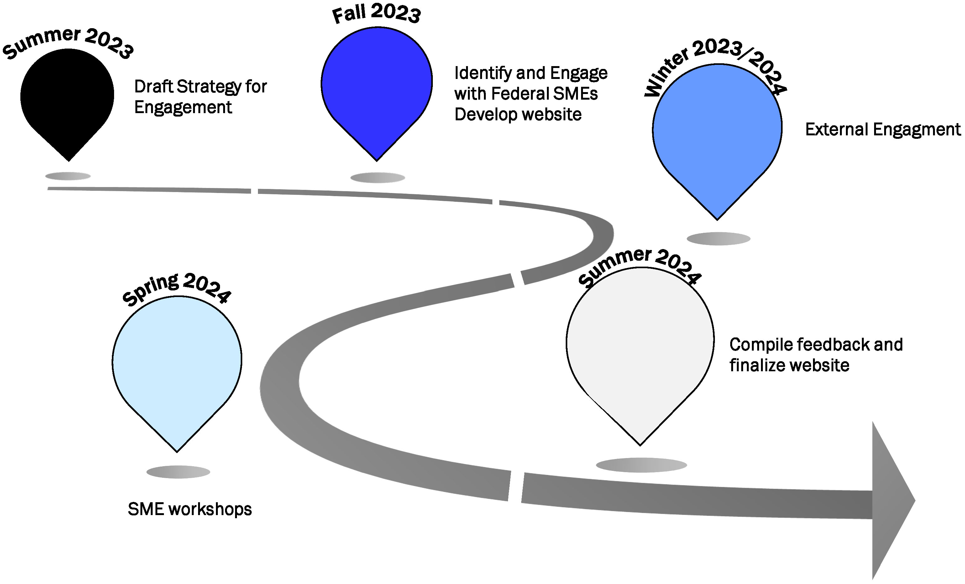
Figure 1 Tentative timeline for the goals of the Interagency Working Group - Ocean Exploration and Characterization (IGW-OEC); starting in June 2023 and ending next year in July 2024. Plans for summer of 2023 will focus on the development of a strategy for engagement to develop the resource repository, followed by initial engagement with federal subject matter experts (SMEs) in the Fall of 2023. External engagement begins during the Winter of 2023/2024, casting a broad net to gather input from non-governmental stakeholders. A series of workshops to refine input are planned for the Spring of 2024, culminating in the public launch as an online repository by Summer 2024.
Once aggregated, we plan to publicly host the federal resources on the NOMEC IWG-OEC website in a searchable and accessible format as the initial framework of the repository. The disciplinary categories identified in the Strategic Priorities for Ocean Exploration and Characterization report (IWG-OEC, 2022, p.20) can be partly used to help guide the development of the initial framework along with the nested subcategories shown in Figure 2 (e.g., acoustics). A government hosted website can serve as an authoritative resource for broader communities, both domestic and international. The website nesting format (Figure 2) also allows for the flexibility to adapt and add to future exploration and characterization data categories, cross-link relevant documents, and inventory protocols and standards across the diverse fields of ocean exploration and characterization. Once initial input from federal agencies is received and subject matter experts are identified, the IWG-OEC plans to host a series of focused discussions to solicit external (non-federal government) stakeholder contributions to the repository.
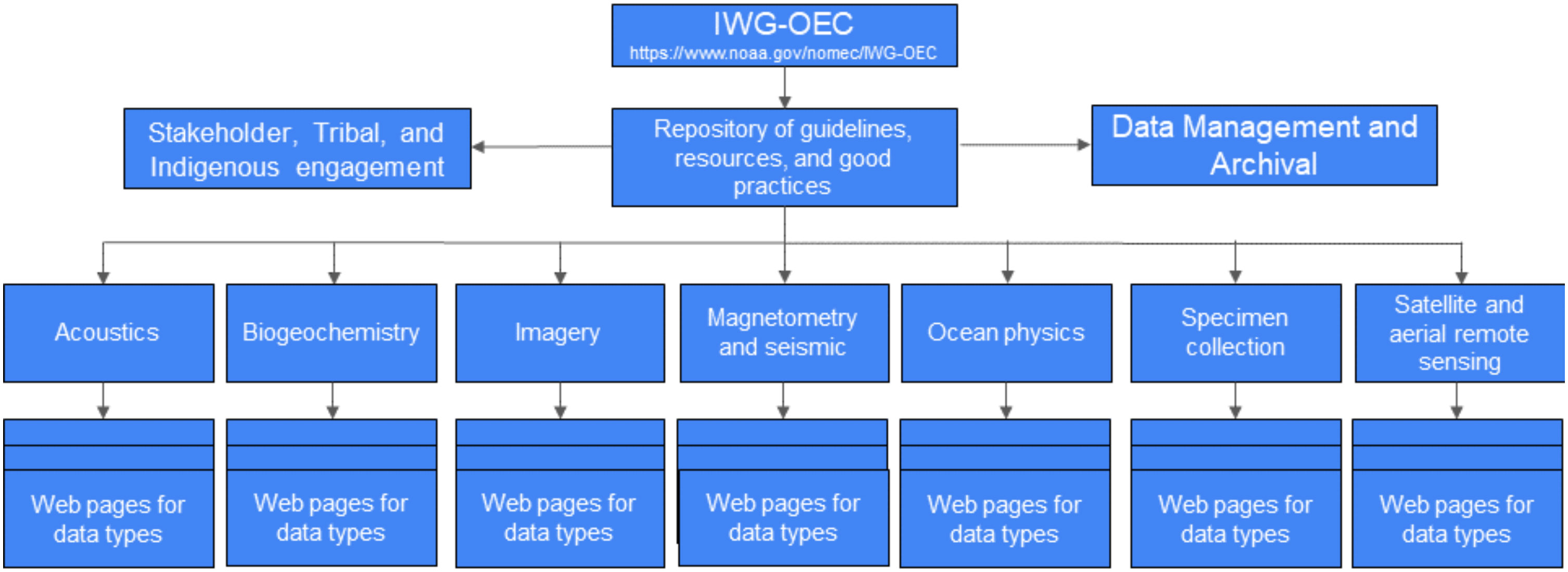
Figure 2 Proposed nested structure of the online resource repository to enable easy navigation of the collected best practices, standards, guidelines, and standard operating procedures. This repository is planned to be housed within the Interagency Working Group - Ocean Exploration and Characterization (IGW-OEC) webpage that is part of the greater National Ocean Mapping, Exploration, and Characterization (NOMEC) website. The initial categories proposed reflect those captured in the Strategic Priorities for Ocean Exploration and Characterization of the United States Exclusive Economic Zone (IWG-OEC, 2022).The goal is for the repository to host online resources, link to other publicly available information, and cross-referenced documents with virtual tags when applicable for multidisciplinary activities. The data types within the categories will be created are intended to be based upon feedback from subject matter experts and stakeholders, and over time the repository structure and content can evolve to best suit the needs of users.
External engagement
The objective of the external engagement phase is to build upon the inventoried federal resources by engaging stakeholders in different disciplines and fields that acquire, process, and use exploration and characterization data sets. The goal is for stakeholders to identify missing protocols, best practices, or data types that should be included and provide feedback to improve the utility of the repository website. We plan to solicit external input through science conference sessions and town halls, workshops, and written input solicited in Federal Register Notices (FRN). Awareness of various opportunities for external engagement can be communicated through science publications, NOMEC Newsletter, and posts to relevant listservs and agency social media channels. Additionally, the IWG-OEC intends to convene small working groups of experts to meet, inform, and identify the primary standards and data outputs that have the highest interoperability and utility to meet ocean exploration and characterization objectives across intersecting disciplines, missions, and sectors. The combined efforts of external engagement can help to proactively gather information from personnel who are working directly with the data types to discuss and improve community-wide guidelines and best practices for the repository.
We plan to group multi-sector subject matter experts into teams by data category or type as identified on the NOMEC IWG-OEC best practices website (Figure 2). Drawing on collaborative knowledge and open discussion, teams can begin to shape the collective vernacular around the guidelines, best practices, and eventual implementation of these standards across the community. A major focus for these teams is the end products of data for the repository: what types of data are collected (i.e., data formats) and what is done with data (i.e., data archival), thus ensuring both accessibility and security. The articulation of these parameters regarding the data is the first and most impactful step in informing and establishing community-driven and produced interoperable standards and protocols for ocean exploration and characterization.
Final product and discussion
By the end of the engagement and development process, our goal is to create a living, online repository of best practices and standard operating procedures as a helpful information-sharing resource for federal agencies and interested stakeholders. Due to the diversity of activities and data types covered, we do not intend for this repository to identify any single method as the standard, but to initiate sharing of information with an open invitation for contributions and continued refinement to capture feedback from users and stakeholders. We intend for this to be an evolving resource that can avoid duplication of effort across disciplines and organizations, build consensus around best practices, and provide a path forward on standardization and interoperability of data.
Establishing the resource repository can help to enable the ocean community and any interested stakeholders to identify what works best for them and voluntarily adopt the best practices to fit their project needs. Additionally, through the collaborative development of the repository, we hope to establish a robust collection of ocean exploration and characterization best practices and standard operating procedures, creating a legacy of open access knowledge that can grow in the decades to come. As technology evolves, the IWG-OEC recognizes that there needs to be room for amendments and alterations to the associated best practices, standard operating procedures, and data formats. This initial effort to compile the collectively determined best practices and standard operating procedures can help to establish a useful baseline and serve to accelerate advancements across the ocean exploration and characterization space.
There is a strong demand and need for data standards across multidisciplinary ocean exploration and characterization communities in order to enable interoperability, accelerate innovation, and spark new lines of inquiry and discovery. The IWG-OEC is tasked with finding a way to tackle and achieve this goal. This is an ambitious goal that cannot and should not be done in isolation without the collaboration and input from federal and state agencies academia, industry, Tribal nations, Indigenous peoples, and NGOs. Substantial involvement from all interested stakeholders can help to align and maintain standards with the latest innovations and improvements. Government participation can provide authoritative information to the entire ocean community. This process of establishing best practices and standard operating procedures can help us all to achieve this daunting goal. A systematic, transparent, and collaborative process to derive agreed upon standards can enhance the interoperability of data and inform new lines of inquiry, discovery, research, and innovation across the ocean exploration and characterization community. This online repository can help the ocean community to identify and utilize the best practices and standard operating procedures to eat the whale that is ocean exploration and characterization, one byte of data at a time.
Data availability statement
The raw data supporting the conclusions of this article will be made available by the authors, without undue reservation.
Author contributions
All authors- KC, AD, MH, RM, MM, and AN, equally contributed to manuscript development and iterative edits. RM, MM, AD as the long serving co-chairs of the IWG-OEC initiated the ideas and project described in this manuscript. All authors approved the submitted version.
Funding
All funding for this work associated with this manuscript is supported by the home agencies of the authors- BOEM Office of Environmental Programs, U.S. Geological Survey and NOAA Ocean Exploration. MGH is funded through the National Sea Grant Dean John A. Knauss Marine Policy Fellowship administered through Washington State Sea Grant at the University of Washington, Seattle, WA. Funding for the ongoing NOMEC actives described throughout this article are supported by agencies represented on IWG-OEC and the NOMEC Council.
Acknowledgments
We would like to acknowledge the past and current members of the Interagency Working Group on Ocean Exploration and Characterization (IWG-OEC) for their collaboration on IWG-OEC activities as well as the NOMEC Council, IWG-OEC, and IWG-OCM co-Chairs and Executive Secretaries, and in particular Ashley Chappel and Amber Butler, for their thoughtful edits and comments during the development of this manuscript. We would also like to thank each of the IWG-OEC participating agencies for their continued support of NOMEC activities and for striving to increase exploration and characterization of the US EEZ.
Conflict of interest
The authors declare that the research was conducted in the absence of any commercial or financial relationships that could be construed as a potential conflict of interest.
Publisher’s note
All claims expressed in this article are solely those of the authors and do not necessarily represent those of their affiliated organizations, or those of the publisher, the editors and the reviewers. Any product that may be evaluated in this article, or claim that may be made by its manufacturer, is not guaranteed or endorsed by the publisher.
Author disclaimer
Any use of trade, firm, or product names is for descriptive purposes only and does not imply endorsement by the U.S. Government.
References
Danovaro R., Fanelli E., Aguzzi J., Billett D., Carugati L., Corinaldesi C., et al. (2020). Ecological variables for developing a global deep-ocean monitoring and conservation strategy. Nat. Ecol. Evol. 4, 181–192. doi: 10.1038/s41559-019-1091-z
Egan K. E., Le J. T., Murphy J. W. A., Netburn A. N., Bohan M., Copeland A., et al. (2021). Exploration Variables Identified by NOAA Ocean Exploration Vol. 004 (MD: NOAA Ocean Exploration. Silver Spring), 136. doi: 10.25923/m37w-8b55
EOP (2019) Ocean Mapping of the United States Exclusive Economic Zone and the Shoreline and Nearshore of Alaska. Federal Register website (Accessed 5 June, 2023).
GOOS. (2021). Essential Ocean Variables. Global Ocean Observing System website (Accessed 15 January, 2021). Available at: https://www.goosocean.org/eov.
Heidelberg K. B., Gilbert J. A., Joint I. (2010). Marine genomics: At the interface of marine microbial ecology and biodiscovery. Microbial Biotechnol. 3, 531–543. doi: 10.1111/j.1751-7915.2010.00193.x
H.R.7776 – 117th Congress (2022) James M. Inhofe National Defense Authorization Act for Fiscal year 2023. Congress website (Accessed 5 June, 2023).
IWG-OEC (2022) Strategic Priorities for Ocean Exploration and Characterization of the United States Exclusive Economic Zone. White House website (Accessed 5 June, 2023).
Levin L. A., Bett B. J., Gates A. R., Heimbach P., Howe B. M., Janssen F., et al. (2019). Global observing needs in the deep ocean. Front. Mar. Sci. 6. doi: 10.3389/fmars.2019.00241
NOAA (2022a) Interagency Working Group on Ocean and Coastal Mapping (IWG-OCM). National Oceanic and Atmospheric Administration website (Accessed 5 June, 2023).
NOAA (2022b) Interagency Working Group on Ocean Exploration and Characterization (IWG-OEC) (National Oceanic and Atmospheric Administration) (Accessed 5 June, 2023).
NOAA (2022c) NOMEC council and Member Agencies. (National Oceanic and Atmospheric Administration) (Accessed 5 June, 2023).
NOAA (2023) Ocean Policy Committee. National Oceanic and Atmospheric Administration website (Accessed 5 June, 2023).
NRC (2003). Exploration of the Seas: Voyage into the Unknown (Washington, DC: The National Academies Press). doi: 10.17226/10844
Office of Science and Technology Policy (OSTP). (2020a). National Strategy for Mapping, Exploring, and Characterizing the United States Exclusive Economic Zone. National Oceanic and Atmospheric Administration website accessed 5 June, 2023. Available at: https://www.noaa.gov/sites/default/files/2022-07/NOMECStrategy.pdf.
Office of Science and Technology Policy (OSTP). (2020b). Implementation Plan for the National Strategy for Ocean Mapping, Exploring, and Characterizing the United States Exclusive Economic Zone. National Oceanic and Atmospheric Administration website, accessed 5 June, 2023. Available at: https://www.noaa.gov/sites/default/files/2021-11/210107-FINALNOMECImplementationPlan-Clean.pdf.
OSTP (2020a) National Strategy for Mapping, Exploring, and Characterizing the United States Exclusive Economic Zone. (National Oceanic and Atmospheric Administration website) (Accessed 5 June, 2023).
Keywords: NOMEC, ocean exploration, ocean characterization, best practices, standard operating procedures, SOPs, interagency coordination
Citation: Cantwell K, Demopoulos AWJ, Hebner MG, Medley R, Mueller M and Netburn AN (2023) One byte at a time: gathering best practices, guidelines, and resources for data standards to support ocean exploration and characterization. Front. Mar. Sci. 10:1250245. doi: 10.3389/fmars.2023.1250245
Received: 29 June 2023; Accepted: 30 August 2023;
Published: 02 October 2023.
Edited by:
Adam Soule, University of Rhode Island, United StatesReviewed by:
Christoph Waldmann, University of Bremen, GermanyCopyright © 2023 Cantwell, Demopoulos, Hebner, Medley, Mueller and Netburn. This is an open-access article distributed under the terms of the Creative Commons Attribution License (CC BY). The use, distribution or reproduction in other forums is permitted, provided the original author(s) and the copyright owner(s) are credited and that the original publication in this journal is cited, in accordance with accepted academic practice. No use, distribution or reproduction is permitted which does not comply with these terms.
*Correspondence: Kasey Cantwell, a2FzZXkuY2FudHdlbGxAbm9hYS5nb3Y=