 Marco Zennaro
 Ermanno Pietrosemoli
 Aziz Soltobaev
 Talant Sultanov2
- 1The Abdus Salam International Centre for Theoretical Physics, Trieste, Italy
- 2Internet Society Kyrgyz Chapter, Bishkek, Kyrgyzstan
- 3Central-Asian Institute for Applied Geosciences, Bishkek, Kyrgyzstan
Kyrgyzstan, a landlocked nation in Central Asia, is characterized by its rugged mountainous terrain, which covers approximately 90% of its land area. This unique geography poses specific challenges related to climate vulnerability. To address these challenges, we propose a comprehensive approach that involves gathering meteorological data and making it accessible to decision-makers. By leveraging LoRaWAN communication technology, which efficiently transmits sparse and low-speed data over long distances while minimizing power consumption, we can enhance climate resilience. The Internet Society Kyrgyz Chapter, in collaboration with the International Centre for Theoretical Physics (ICTP) and the Central Asia Institute for Applied Geosciences (CAIAG), has initiated the installation of meteorological sensors and disaster mitigation devices, including river water level sensors, terrain moisture sensors, and tilt detectors. These sensors collect critical data, which are stored within the country on an ad hoc server. Stakeholders can access these data according to their specific requirements. This paper outlines the criteria for selecting the deployed equipment and provides details on the installation process at pilot sites, along with the challenges encountered during project execution.
1 Low-cost wireless weather stations
Recent research has shown advances in the performance of low-cost, low-power, and long-range weather stations. These stations offer a cost-effective solution for monitoring weather conditions in both developed and developing countries. The use of technologies such as LoRa (Long Range) wireless networking for the Internet of Things (IoT) has enabled the development of weather stations that can cover large areas while consuming minimal power. These stations are equipped with various sensors to monitor parameters such as temperature, humidity, air pressure, wind, and amount of rain. The data collected can be stored in cloud servers and accessed remotely. The implementation of these weather stations aims to adhere to the standards set by organizations such as the World Meteorological Organization (WMO) (World Meteorological Organization, 2024). The relevance of these advances lies in their ability to provide accurate weather predictions, which can have significant impacts on sectors such as disasters mitigation, agriculture, hydroelectric powering, and tourism.
In addition, the low-cost nature of these stations makes them more accessible and affordable for deployment in developing countries where resources are more limited. The cost of ‘traditional’ weather stations can raise to many thousands of dollars as reported in the Kyrgyz national news in October 2023: ‘There is now a weather station in At-Bashy (village): the cost is $80 thousand’ (https://www.turmush.kg/ru/news:2011739/). On the contrary, the cost of IOT/LoRaWAN stations starts at $1,000. In this project we used equipment produced by different manufacturers. For illustrative purposes the following link provides information of Barani Design (https://allmeteo.com/weather-station-solu.tion-price-table): and of Seeed Studio (https://www.seeedstudio.com/SenseCAP-S700-7-in-1-Compact-Weather-Station-p-5651.html). Prices of both weather stations are below $1,000.
As an example of new development, the integration of satellite downlink signal attenuation measurement for real-time rain rate evaluation presents an interesting aspect compared to other consolidated precipitation measurement instruments (Giro et al., 2022). This system, endorsed by leading satellite operators and weather forecast market players, showcases the potential for developing new services based on additional data, highlighting the exponential growth in the business related to weather data. Moreover, the use of city buses as mobile weather stations for real-time weather monitoring and prediction demonstrates an innovative approach to achieving a better balance of coverage than static observatories (Huang et al., 2020). The system utilizes local information processing and bus mobility to monitor minute details and weather changes within a specific area, delivering highly detailed weather information and updates at frequent intervals, by leveraging artificial intelligence techniques. Lastly, the development of collaborative approaches for agricultural development, such as low-cost weather stations for climate-smart agriculture, emphasizes the importance of such technologies in enhancing agricultural productivity and sustainability in developing countries (Botero-Valencia et al., 2022), (Tenzin et al., 2017). These systems offer affordable, accessible, and real-time monitoring capabilities that are vital for mitigating climate change impacts and promoting sustainability.
The current advancements in low-cost, low-power, and long-range weather stations are highly relevant for developing countries and emerging economies. They offer innovative solutions for environmental monitoring, agricultural development, and climate change mitigation, providing critical support for informed decision-making and sustainability efforts in resource-constrained settings. In Section 2 we provide some background information about Kyrgyzstan, Section 3 describes the proposed architecture, in Section 4 we describe some commercial LoRaWAN gateways. LoRaWAN equipped sensors are examined in Section 5. Software tools used are explained in Section 6. Description of the current deployments is undertaken in Section 7. Section 8 deals with training, Section 9 is about preliminary results, while Policy Implications and Integration with Climate Adaptation Strategies are considered in Section 10, followed by conclusions in Section 11.
The following table presents examples of LoRaWAN projects.
2 Kyrgyzstan
Kyrgyzstan, also known as the Kyrgyz Republic, is a sovereign state in Central Asia. It is renowned for its stunning natural landscapes, predominantly consisting of mountain ranges like the Tian Shan and Pamir. The nation’s capital and largest city is Bishkek, which serves as the administrative and economic hub. With a population estimated at around 7.25 million in 2024, Kyrgyzstan is home to a diverse array of ethnic groups, while the Kyrgyz people make up the majority. The country’s official languages are Kyrgyz and Russian, reflecting its history and cultural richness. Economically, Kyrgyzstan shows a mixed performance. Its Gross Domestic Product (GDP) was estimated at $13.758 billion in 2024, with a per capita income of around $2,000. The economy relies heavily on agriculture, mining (especially gold), and remittances from citizens working abroad. Despite low income levels and economic challenges, Kyrgyzstan has a relatively low Gini coefficient, indicating a more equitable distribution of income compared to many other countries. Kyrgyzstan’s history is marked by its position along the Silk Road and its succession under various empires and powers. Today, it is a unitary presidential republic, having declared independence from the Soviet Union in 1991. The country continues to navigate its path towards economic stability and growth, leveraging its natural resources and strategic location.
2.1 Geography and climate change
Kyrgyzstan boasts a diverse geography characterized by its rugged mountainous terrain, which encompasses approximately 90% of its land area. The country is defined by the imposing presence of the Tien Shan range, which traverses its territory from east to west. This mountain system is renowned for its majestic peaks, including Peak Pobeda, standing at 7,439 m, and Khan Tengri, reaching 7,010 m above sea level. The Tien Shan range not only serves as a geographical hallmark but also influences various aspects of Kyrgyzstan’s environment and society. Around 90% of Kyrgyzstan’s electricity generation comes from hydropower. Its towering summits contribute significantly to the nation’s climatic diversity, acting as a barrier to moisture-laden air masses, thereby influencing precipitation patterns across the region. Moreover, the mountains serve as reservoirs for glacial meltwater, crucial for sustaining downstream ecosystems and supporting agricultural activities in the fertile valleys below. Beyond their environmental significance, the mountains of Kyrgyzstan also hold cultural and historical importance, serving as a backdrop to nomadic traditions and ancient trade routes that have crisscrossed the region for centuries. Despite the challenges posed by the rugged topography, such as limited arable land and difficult access to remote areas, the mountains also offer opportunities for tourism, particularly in the realm of ecotourism and adventure sports like mountaineering, trekking, mountain biking and skiing. Thus, while the mountains of Kyrgyzstan present both obstacles and opportunities, they remain central to the country’s identity, shaping its landscape, culture, and socio-economic development. Among the countries in Eastern Europe and Central Asia, Kyrgyzstan is the third most vulnerable to the effects of climate change (Kyrgyzstan ranks, 2024), (Kyrgyzstan, 2024). The average temperature has increased from 5.8°C to 6°C in the last 20 years. In 2013 the World Bank estimated a likely increase of 2°C in average mean temperature by 2060 and of 4°C–5°C by 2,100, noting that the country’s glaciers were significantly reduced and projected to decline further.
2.2 Telecommunications infrastructure
Kyrgyzstan’s telecommunications infrastructure reflects the country’s efforts to modernize and expand connectivity in recent years. The sector is primarily overseen by the Ministry of Digital Development, which regulates telecommunications policies and fosters industry growth. Kyrgyzstan has made significant strides in expanding its telecommunications network, with widespread coverage of mobile and Internet services across urban and rural areas. Mobile penetration rates are relatively high, driven by competition among several major operators offering 3G and 4G services. Mobile penetration rates have plateaued at around 140% in terms of population, indicating saturation in the market. Nevertheless, rural areas with low population density are not served (GSMA, 2024), as can be observed in Figure 1.
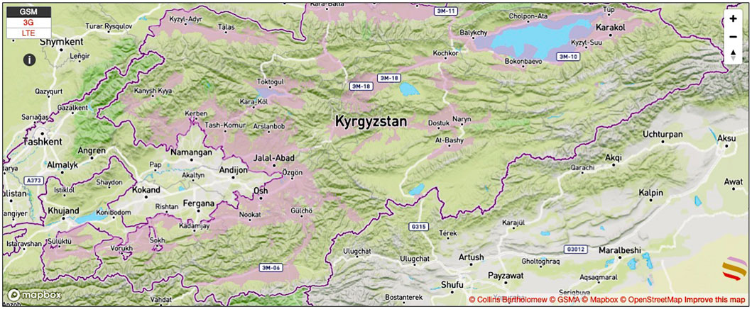
Figure 1. Cellular network coverage in Kyrgyzstan (areas in pink color) showing that rural areas with low population density and remote areas are not served.
The country has also witnessed increasing adoption of broadband Internet, facilitated by investments in fiber-optic infrastructure and satellite connectivity. Approximately 1.9 million people in Kyrgyzstan use the Internet, a number expected to grow. Despite these advancements, challenges persist, including the need for further investment in rural connectivity, ensuring affordable access for underserved populations, and addressing cybersecurity concerns. Looking ahead, the government’s focus on digitalization and e-governance initiatives underscores the importance of continued investment in telecom infrastructure to support economic growth and social development in Kyrgyzstan.
2.3 Central Asia institute of applied geosciences (CAIAG)
The Central Asian Institute of Applied Geosciences (CAIAG) (Central Asian, 2024), an independent non-profit organization, was established in 2002 through a cooperative agreement between the Government of the Kyrgyz Republic and the German GeoForschungs Zentrum in Potsdam, Germany. CAIAG’s mission revolves around applied geoscience research, environmental monitoring, and sustainable resource management. The research focus of CAIAG includes the management of dedicated monitoring networks for seismology, geodesy, and hydro-meteorology, including installation of high mountain observatories that provide critical data on glacial dynamics and water resources and the maintenance of observational data that are managed within a Geodata Information System, including a geodatabase and web interfaces for open access.
3 Proposed solution
LoRaWAN (Long Range Wide Area Network) is a communication protocol designed for low-power, long-range wireless connectivity. It enables devices to communicate with Internet applications over extended distances. Examples of LoRaWAN based environmental sensing projects is presented in Table 1. A comparison of LoRaWAN with other WAN technologies is presented in Table 2, followed by a short explanation of the entries.
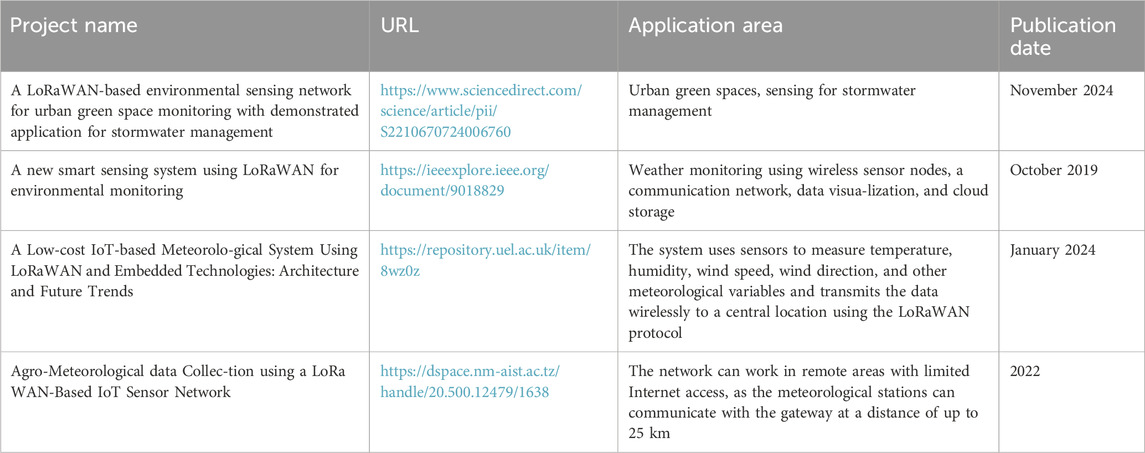
Table 1. Examples of LoRaWAN based environmental sensing projects.
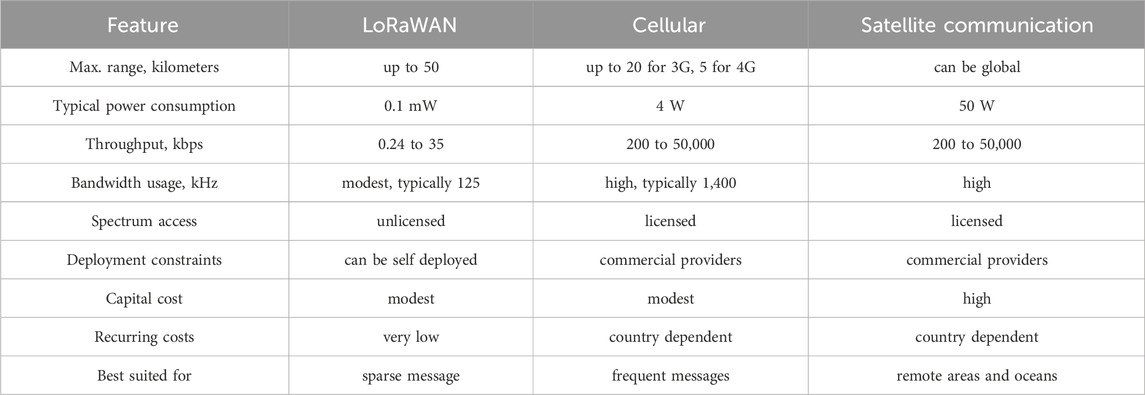
Table 2. Comparison of some WAN technologies.
The maximum range depends on the frequency used and on the power budget, which is the difference between the transmitted power and the receiver sensitivity. LoRaWAN has a lower transmitted power but a much better receiver sensitivity than traditional cellular technologies. Newer cellular technologies like NB-IoT and LTE-M can have higher power budgets but they are not yet available in most countries.
Power consumption is very low in LoRaWAN, since the transmitted power is very low and when the device is idle consumes very little power. A cellular modem, in contrast, must keep frequent exchanges with the base station even when there is no traffic.
LoRaWAN throughput is very low, but is sufficient to transmit weather data. Cellular has a much higher throughput. Satellite systems can offer different amounts of throughput.
LoRaWAN is deployed in unlicensed bands, which means that there is no cost associated with the spectrum usage. Alternatives use licensed bands, with significant costs that must be borne by the customers.
LoRaWAN can be deployed by a small organization, relying on public network servers, or the service can be bought from commercial service providers. The alternatives are only offered by service providers that have paid for the licensed spectrum and the infrastructure.
Capital costs in LoRaWAN include the End Node transceiver and the LoRaWAN gateway. Each gateway can serve a number of End Nodes within its coverage area. In Cellular, each sensor must be equipped with a cellular modem that communicates directly with the Cellular infrastructure, and no gateway is required thus potentially reducing the capital cost.
LoRaWAN recurring costs are limited to the equipment maintenance and the cost of the cellular service only for the gateway traffic, whereas in a cellular deployment each sensor has a recurring cost.
So LoRaWAN is best for applications with low throughput requirements and limited number of messages, Cellular is better for higher throughput and real time traffic. Satellites excel for video broadcasting, are very good for very remote areas and the only alternative for open oceans.
3.1 LoRaWAN architecture
LoRaWAN networks follow a star-of-stars topology, where End Devices (ED) communicate with nearby Gateways, which connect to a Network Server. Energy consumption is minimized since the end device only wakes up when it needs to send data; after each transmission two short receive windows are established during which the end device can receive downlink commands or data and then returns to sleep. Messages are detected by all gateways within range, ensuring robust coverage. The key components in the standard LoRaWAN architecture are.
Figure 2 shows on the left a standard LoRaWAN architecture, where the End Nodes send sensor’s data to a Gateway which is connected via TCP/IP to a Network Server. The Application Server decrypts the specific data stream thus preserving the privacy from other applications handled by the Network Server. On the right of Figure 2, the proposed architecture in which all the servers and the Gateway are integrated in a disruption tolerant gateway (DTG) is shown.
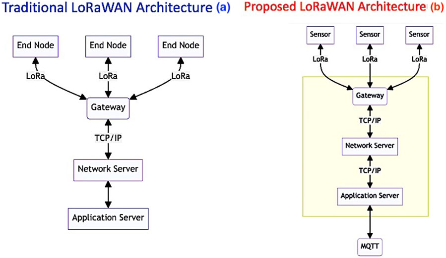
Figure 2. Comparison of the standard LoRaWAN architecture (a) with the proposed solution (b) that integrates the various servers and the gateway in the same box, adding disruption tolerance.
4 Commercially available LoRaWAN gateways
Indoor LoRaWAN gateways are not weatherproof, typically have only internal antennas and connect to the Internet by means of a wired Ethernet or WiFi. There are a number of vendors that offer outdoor LoRaWAN gateways, the ones useful to collect environmental data in extreme climates should meet the following criteria.
Table 3 compares some LoRaWAN gateways that meet these requirements.
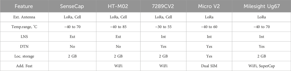
Table 3. LoRaWAN outdoor gateways.
4.1 SenseCAP outdoor gateway - LoRaWAN EU 868 MHz
This device (SenseCAP, 2024) has a built in server that provides the required LoRaWAN servers with MQTT support. The IP66 enclosure makes it weather resistant over the −40°C to 70°C temperature range, offers 8 GB eMMC memory, supports a wide number of 4G bands with an SMA connector for an external antenna. It has an internal LoRa antenna and also supports an external one. The receiver sensitivity is −139.5 dBm. Consumption is 3.6 W at 12 V, which is supplied through a weatherproof connector. The CPU is the TI AM3358 Cortex-A8 running at 1 GHz.
4.2 Heltec HT-M02 (V2)
This IP66 all aluminum case gateway (HT-M02, 2024) has an operating temperature from −40°C to 85°C, uses the new SX1303 chip, which has better sensitivity than the SX1301 and improved positioning capabilities. It has a 4G modem (Cat. 1 and Cat. 4) and can be powered from 4.5 to 17 V.
It can connect to various network servers such as TTN and Chirpstack.
4.3 Rak 7289CV2
This recently introduced gateway (Outdoor LoRaWAN, 2024) has an LTE modem and a built in Wi-Fi Access point for configuration. It has a Chirpstack server that implements all the requirements for a private LoRaWAN network with MQTT support. It buffers LoRa frames in Packet Forwarder mode to prevent data loss. The IP 67 enclosure houses the LTE, Wi-Fi, and GPS antennas, which means that the installation of the gateway must take into account the direction of the closest Cellular tower, since the metallic components will disrupt the antenna radiation pattern. Operating temperature is from −30°C to +55°C. The LoRa antenna is external, so it can be omnidirectional. It has cable glands for the 12 V supply.
4.4 Browan Outdoor Micro Gateway V2
This model (Outdoor Micro Gateway, 2024) can receive up to 16 concurrent channels, and has connectors for external antennas (LoRa, 3G/4G and GPS). There is no Wi-Fi radio. The Ethernet port supports 10/100/1,000 Mbps and can be used to power the device, as an alternative to 12 V DC used in conjunction with solar power. Offers IP68 ingress protection, with a temperature range from −20°C to 60°C (optional for −40°C 60°C). It contains a LoRaWAN network server embedded and supports downlink LBT (Listen Before Talking) as well as MQTT. Supports dual SIM cards and has multiple watchdogs for system monitoring.
4.5 Mikrotik Knot LR8
An IoT LoRa Gateway that uses both NB-IoT and CAT-M technologies. Does not support legacy 3G and 4G. Tested at temperatures from −40°C to 70°C. Maximum power consumption is 23 W. Supports Bluetooth version 5.2. It is not weatherproof but it could be housed in weatherproof box. It must be connected to an external network server (KNOT, 2024).
4.6 Iridium Urb-IoT outdoor
This is a LoRa Gateway (Urb-IoT, 2024) that can also connect to the Iridium Satellite network, besides cellular, Bluetooth and WiFi, so it can be deployed in places lacking Cellular coverage. Supports both LTE-M and NB-IoT. Rated IP 68, does not have external antennas. It handles data locally to reduce data transmission and cloud processing. The temperature range is from −40°C to +70°C. The 20,100 mAh battery can lasts up to 72 h, and the gateway can be powered through a USB-C IP68 connector at voltages from 5.4 to 13.5 V. It supports GPS, GLONASS, Beidou and Galileo. There are recurring charges for the service which are handled by local partners.
4.7 DTG: disruption tolerant gateway
In the context of deploying LoRaWAN networks in extreme and rural environments, a significant challenge arises due to the intermittent availability of cellular networks in remote areas. These networks often experience prolonged outages, primarily because they rely on diesel generators for power, which can be unreliable. Furthermore, fuel supply in remote areas poses additional challenges. To address this issue, gateways must be equipped with local data storage capabilities. When the cellular service becomes operational again, the gateway should automatically transmit the stored data to prevent any gaps or discontinuities in the records. The key component of our proposed LoRaWAN architecture is a Disruption Tolerant Gateway, able to address the following possible causes of disruption.
1. Lack of power at the Gateway
2. Lack of power at the cellular Base Station
3. Coverage issues of the cellular Base Station for end nodes
Item one can be addressed by installing a photovoltaic system with a suitable solar panel and battery even if the system is connected to the electrical grid, to prevent power interruptions. Item two can be addressed by storing data in a local buffer to send them when the Cellular Base Station becomes again available. For Item 3, while the gateway must have Internet connectivity, and therefore must be within the cellular service coverage area or have satellite connectivity, the sensors need only be within the coverage area of the gateway, which under line of sight conditions can be dozens of kilometers. So there is no need for the sensors to be under Cellular coverage.
Figure 2b depicts the proposed solution, where the DTG includes a LoRaWAN gateway as well as all the required Network and Application servers shown in Figure 2a.
We initially developed a prototype that used a dual SIM (Subscriber Identification Module) cellular modem, a Raspberry Pi (Single Board Computer) with local storage in a micro SD (Secure Digital) card and a concentrator module (the radio part of a gateway). The prototype worked well as a proof of concept, but it required a significant amount of customization, hampering its usefulness for large scale implementation in remote areas. After having examined other commercially available LoRaWAN gateways, we found that the Milesight UG67 (Outdoor LoRaWAN® Gateway, 2024) fits most of our requirements. It has 8 GB of flash for local data storage and supports the MQTT protocol which addresses the disruption of communication with the cellular base station. It also has internal Network, Application, Join and Authentication servers so it is a very complete solution. The only shortcoming with respect to our prototype is that the cellular modem does not support dual SIM. This is not of paramount importance in our use case, since in most remote areas only a single Cellular operator is available. UG67 is a robust 8-channel outdoor LoRaWAN gateway that supports connection with more than 2000 nodes. It has an IP67 (Ingress Protection) waterproof case making it a suitable solution for remote environments.
Tests were performed in the lab to assess the disruption tolerance, and indeed in the absence of Cellular connectivity the UG67 stored the sensor’s messages in the internal 2 Gigabyte memory. When Cellular connectivity was restored, the messages were successfully received through the MQTT protocol. Given the small size of messages originating from one weather station, more than 2 years of stored messages can be saved in the internal memory.
The on board Ethernet interface can also be used to connect to a satellite modem in cases where no terrestrial connectivity is available. It can be powered at 12 V through a weather protected connector facilitating its connection to a photovoltaic system. We therefore decided to use the UG67 for the field deployment in Kyrgyzstan.
4.8 Section summary
We have presented some of the available gateways that satisfy at least part of the requirements of our project. The final choice was guided by the following considerations:
The SenseCAP meets all our requirements, and it is a good option, but has less memory and therefore less resiliency regarding the loss of cellular connectivity. The Heltec has very good gateway features, but does not have the internal servers needed for DTG capabilities. The Rak7289 is a very good new contender but we have had no opportunity to test it. The Browan V2 is a newer version of a gateway that we have tested in the past, which had no server capabilities. We plan to test this model which, compared with the Milesight, has the advantage of dual SIM support and external 3G/4G antenna. The Mikrotik Knot is power hungry and does not have internal servers or weather resistant capabilities. The Iridium is very convenient for places outside the cellular coverage, but requires monthly payments for the satellite service. Furthermore, there are no Kyrgyzstan partners listed in Iridium’s website. We therefore chose the Milesight UG67 gateway as the best suited for our purpose.
5 LoRaWAN equipped sensors
A number of sensors fitted with a LoRaWAN transceiver so that they can be configured to automatically transmit the collected data to any gateway on range for further forwarding to the selected servers are commercially available. In addition, most sensors not so equipped can be connected to a LoRaWAN transceiver module using standard interconnection buses.
For instance, the Ubiq Weather Station WS 1001 consists of the well known Davis meteorological weather station fitted with a LoRaWAN module. It measures air temperature and relative humidity, rainfall, wind speed and direction and solar radiation. We have tested it and has good performance, but it uses the non rechargeable LSH20 3.6V lithium-thionyl chloride battery, which lasts about 1 year transmitting every 20 min. Since we need to transmit every 10 min, this is a significant shortcoming, given the difficulties in replacing batteries in remote places.
We have also tested the Seeed Studio SenseCAP S1000 V2 10-in-1 Compact Weather Sensor, which measures air temperature, relative humidity, barometric pressure, light intensity, rainfall (optical), wind speed, wind direction (ultrasonic), PM2.5, PM10 and CO2. The use of optical and ultrasonic sensors is very convenient as compared with the standard sensors based on rotating devices, and we are currently comparing their accuracies with respect of standard devices. The S1000 uses an external unit for the LoRa transmission and for connection to the power source.2
A cheaper alternative, the Seeed Studio SenseCAP S2120 8-in-1 LoRaWAN Weather Station, is interesting and we are currently performing tests to ascertain its accuracy.
The Milesight IoT Weather Station3 is a very complete solution, fitted with an external solar panel and battery, but is quite expensive compared with the alternatives.
The same applies to the ATMOS 41W Wireless All-In-One Weather Station4, which supports only a Cellular modem but not LoRa.
Therefore, for our project, we chose the MeteoHelix IoT PRO from Barani Design technologies described in next section.
5.1 Barani weather station
The MeteoHelix IoT PRO5 is a micro-weather station based on new IoT wireless technologies and sensors. Featuring a patented helical design enclosure, it can meet quality standards for climatic observations as set by the World Meteorological Organization (WMO) without using any power consuming fan. It measures temperature, humidity, atmospheric pressure, and solar irradiation, from which dew and frost points are derived with good accuracy levels. The MeteoHelix IoT PRO has a small solar panel that charges an internal Lithium Ion battery that allows over 3 months of operation without sun. We also deployed the stand-alone MeteoWind IoT Pro wind sensor and the MeteoRain 200 Compact sensor, which have their own LoRaWAN transceivers and meet quality standards as defined by WMO.
5.2 Additional LoRaWAN equipped sensors
Statistics from the Centre for Research on Epidemiology of Disasters (CRED) (Brussels, Belgium) show that landslides are responsible for at least 17% of all fatalities from natural hazards worldwide (Disasters in numbers, 2022), (Chae et al., 2017). The recent disaster in Papua New Guinea (Papua New Guinea landslide, 2024) is a striking example of great human loss.
For landslide mitigation purposes, it is also necessary to install soil moisture and temperature sensors, buried at certain depths, as well as tilt sensors above the ground. The latter measure the angle between the instrument body and the plumb line in two horizontally perpendicular directions. These instruments provide valuable data to assess the probability of landslides. We chose the SenseCAP S2105 from SEEED Studio for moisture and temperature measurement (SenseCAP S2104, 2024) and the Milesight - EM310-TILT (Tilt Sensor, 2024) for inclination angle measurement, since they are already equipped with LoRaWAN transceivers.
Figure 3 shows the location of the soil moisture and temperature in the Tatyr site. Examples of the daily inclination readings are presented in Figure 4. Similar deployments were made in other landslide prone areas.
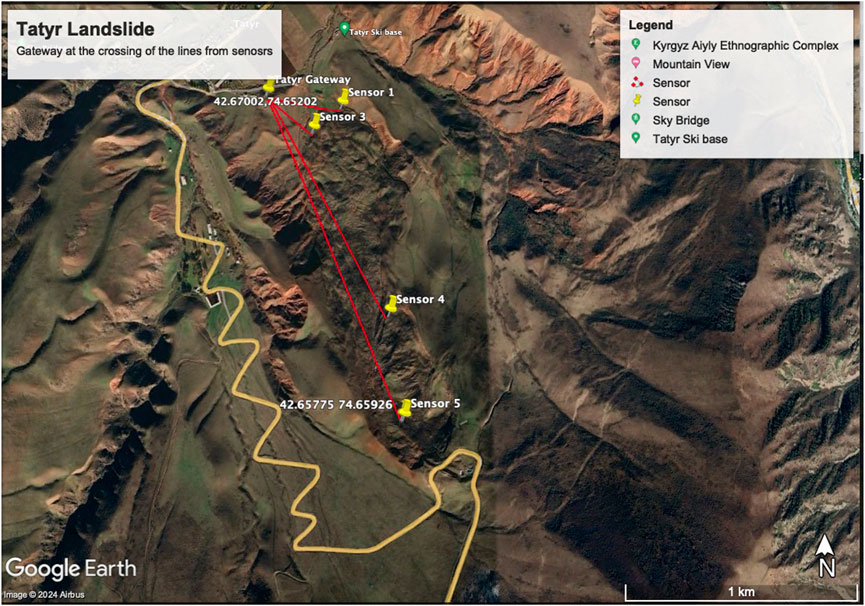
Figure 3. LoRaWAN equipped soil moisture and temperature sensors send data to the DTG gateway in the Tatyr site.
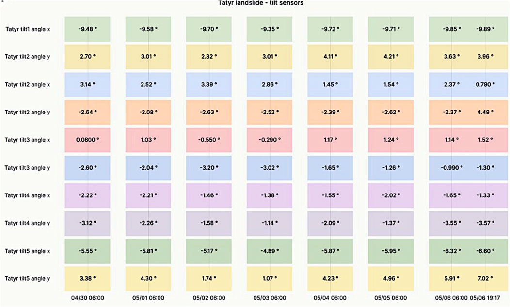
Figure 4. Angular displacement recorded by the tilt sensors in the Tatyr site.Tilt one is the first angular displacement sensor installed at this site. Angle x refers to the displacement of the sensor in a chosen direction, while angle y corresponds to the angular displacement in 90° offset direction. When the angular displacement exceeds a specified threshold, an alarm will be transmitted and made available to relevant stakeholders.
Besides periodic transmissions, the tilt sensors can be programmed to send a message whenever a given angle threshold is surpassed. This is very useful for disaster prevention purposes.
Regarding flood prevention, measuring the water level in upstream rivers is of paramount importance. We therefore installed an ultrasonic distance meter in a bridge over the Ala Archa river, the Milesight EM500-UDL. Subtracting the current distance measurement from the maximum reading ever captured provides an indication of the river water level. Turbulence can cause erratic readings, so data filtering is required to eliminate outliers. Figure 5 shows an example of the water level readings obtained, in which it is possible to observe the fluctuations due to the turbulence.
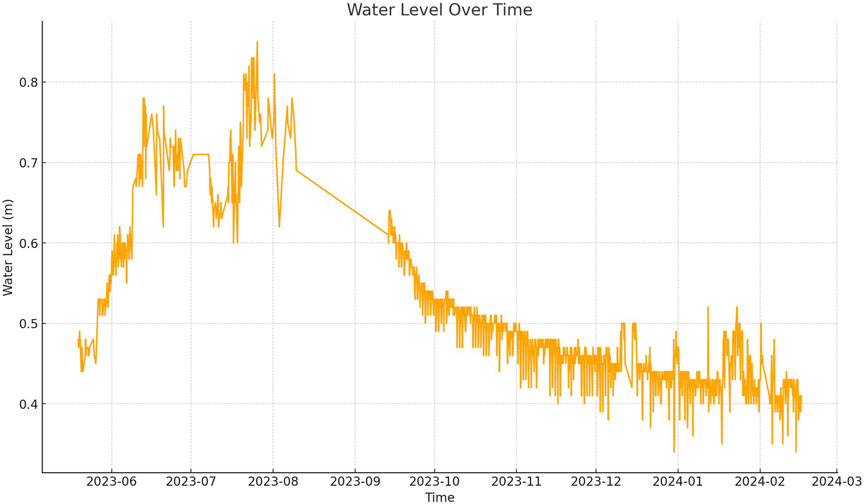
Figure 5. Water level sensor measurements.
6 Software tools
6.1 MQTT protocol
The MQTT protocol has emerged as a prominent communication standard for the Internet of Things (IoT) and other resource-constrained environments. Its lightweight design, efficient message exchange, and publish-subscribe model make it well-suited for scenarios where low bandwidth, limited processing power, and intermittent connectivity prevail.
The MQTT protocol is a client-server messaging protocol designed to facilitate efficient communication among devices in distributed systems. It operates over TCP/IP or other transport protocols, providing a lightweight and reliable mechanism for exchanging messages. The central tenet of MQTT lies in its publish-subscribe paradigm, where clients (both publishers and subscribers) interact with a central broker. MQTT employs a topic-based publish-subscribe model, allowing publishers to disseminate information to multiple subscribers interested in specific topics. Publishers send messages to a broker, which then forwards them to relevant subscribers based on their specific interest. This decoupling of publishers and subscribers enables scalable and flexible communication. MQTT offers three levels of QoS, which apply to both the data sent to the broker and to data retrieved by the subscriber.
The choice of QoS level depends on the application’s requirements and network conditions. As we cannot rely on a stable connection in rural areas, we decided to opt for QoS two in our DTG. MQTT is particularly well-suited for low-bandwidth networks and battery-powered sensors. MQTT supports authentication and encryption mechanisms.
6.2 Telegraf, influx and grafana
The TIG stack, comprising Telegraf, InfluxDB, and Grafana, represents a set of open-source tools tailored for efficient collection, storage, visualization, and alerting of system metrics. This stack finds widespread adoption in IoT. Telegraf, an integral part of the TIG stack serves as a versatile agent responsible for gathering and aggregating data from various sources including MQTT. Telegraf boasts a modular design, allowing seamless integration with diverse systems, databases, and devices. Metrics are pushed to InfluxDB, the designated data store. InfluxDB serves as the repository for time-series data ingested by Telegraf. It excels in handling high-frequency writes, making it ideal for real-time data streams. Users define retention policies to manage data retention duration. Historical data can be pruned or downsampled based on policies. InfluxQL enables SQL-Like Query Language for data retrieval. Grafana complements the stack by providing a modern, customizable dashboarding solution. It offers a rich array of visualizations (line charts, heatmaps, gauges) and panels (graphs, tables, alerts), as shown on Figure 6 for the case of Kyrgyzstan, and users can create dynamic dashboards by combining multiple panels. Grafana seamlessly integrates with InfluxDB as a data source. Grafana supports alert rules based on thresholds or anomalies.
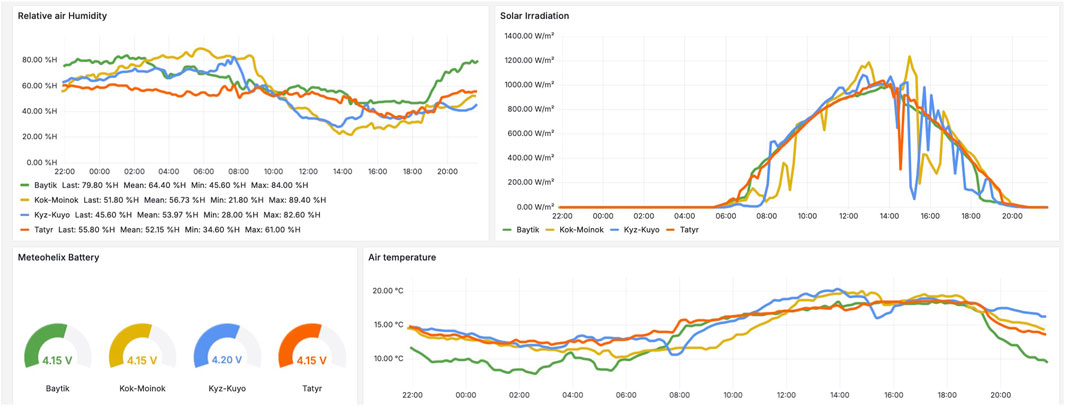
Figure 6. Home dashboard of the Grafana tool showing relative humidity, irradiance, battery voltage and air temperature for the Baitik, Kok-Moinok, and Kyz-Kuio sites on 4 June 2024. Comparison of the value of the same parameters at different sites is an important clue for weather prediction, in particular the fluctuations in solar irradiance in the yellow and blue traces indicates the presence of clouds in several intervals, while a single cloud occurrence is shown in the red trace.
6.3 OpenVPN
To be able to connect to the gateway remotely we deployed Open VPN. OpenVPN is an open-source virtual private network (VPN) solution that stands as a robust and widely adopted protocol for secure communication over untrusted networks. It offers a flexible and extensible framework for creating encrypted tunnels between devices, ensuring confidentiality, integrity, and authenticity of transmitted data. Each IoT gateway connects using its specific encryption method, and access to services is secured through encrypted login credentials. By using an OpenVPN server hosted at ISOC Kyrgyz Chapter, we are able to remotely connect to the gateways to perform maintenance, updates and to add new devices. A Virtual Private Network (VPN) server has been established to facilitate internal communication with LoRaWAN gateways within an AlmaLinux environment. AlmaLinux OS, an open-source operating system, underpins the server’s environment. Connectivity to the machine, both for SSH access and maintenance purposes, is maintained via its designated IP address. Within this network, four gateways are connected through the tunnel subnet provided by the VPN. Additionally, the server interfaces with the external network through Network Address Translation (NAT).
6.4 System architecture
The complete system architecture is presented in Figure 7, which shows the flow of data from the sensors to the gateway using the LoRaWAN protocol, making them available to the stakeholders using MQTT over TCP/IP on an InfluxDb, displayed on a Grafana platform.
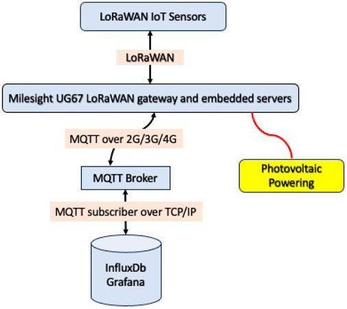
Figure 7. The LoRaWAN protocol is used to transmit sensors’ data to the Milesight UG67 LoRaWAN gateway. Data is transferred internally to the network server and encapsulated in IP packets sent through the Cellular network using the MQTT protocol. The MQTT Subscriber retrieves data from the MQTT Broker. Finally, the data is stored in an InfluxDB database and visualized using Grafana. Light blue background identifies hardware with related software components. Yellow background is a hardware only component. Pink background correspond to protocol components.
By using unlicensed frequencies and self deploying the infrastructure, the only recurring costs are those associated with the cellular service for the gateways. The cost of mobile connectivity is 490 Kyrgyz Soms per year (equivalent to 5.7 USD). Source: https://m2m.mega24.kg/. Each gateway can connect several sensors.
7 Deployments in Kyrgyzstan
As part of an ISOC Foundation-funded project, the Internet Society Kyrgyz Chapter and the ICTP deployed four pilot systems, including four gateways, four meteorological sensors, water level sensors, soil moisture sensors and tilt sensors in different regions, as shown in Figure 8. A fifth site at Adygene Lake is currently being installed.
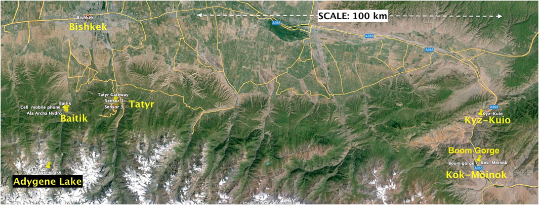
Figure 8. Location of the five pilot sites for the environmental sensors installations. At every site the installed LoRaWAN gateway transfers the collected data to nearest Cellular base station.
7.1 Baitik and Ala Archa Hydropost
The selection of this site was strategic, not only due to its location but also due to the unique opportunity it presents for comparing data with existing meteorological stations. By analyzing and comparing data gathered from these stations, the team validated the consistency, accuracy, and relevancy of the data generated by the LoRaWAN-enabled technology. The Baitik Meteorological Center, located in a significant climatic area, offers critical insights into local and regional weather patterns. The Ala Archa Hydropost plays a crucial role in monitoring water levels, enabling early detection and warnings of potential floods. The installation of LoRaWAN-enabled sensors at these locations greatly enhances the timeliness of data collected, further aiding in the decision-making process for disaster management.
7.2 Tatyr
The Tatyr landslide is geographically situated between 30 and 40 km south of Bishkek. Administratively, the area is part of the Arashan Aiyl district within the Alamedin district. Formed on a north-facing slope, the landslide extends for 1,510 m, with a width varying between 250 and 300 m, and a thickness ranging from 10 to 15 m. The landslide involves loamy soils, encompassing the underlying Paleogene-Neogene age rocks. Its formation is primarily attributed to anomalous atmospheric precipitation, coupled with the impact of groundwater emerging as springs, and a proximate tectonic fault. The last significant activity was recorded in 2004 when the landslide moved 70 m following a year of intense rainfalls. The landslide lies along the route to popular skiing locations and tourist destinations. Previously, monitoring was performed manually through periodic on-site visits. The site’s proximity to Bishkek city made it an ideal pilot location for this research project, allowing for swift sensor validation of research goals. Besides the meteorological sensors, five soil temperature and moisture sensors were sunk at different depths and distances from the gateway as shown on the left side of Figure 9.
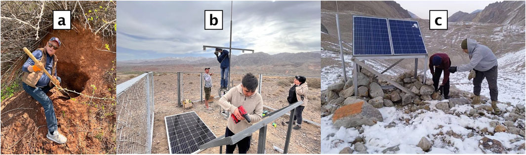
Figure 9. Picture (a) digging to install temperature and soil moisture sensors at Tatyr. Picture (b) Gateway installation in Boom Gorge, serving both Kyz-Kuio and Kok-Moinok sensors. Picture (c) High altitude solar panels at Adygene lake.
Being this a landslide prone area, five tilt sensors were also deployed to measure the terrain inclination, as an early warning for potential landslide events. So a total of 23 variables are collected from this site, since the deployed weather station has sensors for air temperature, air humidity, barometric pressure, solar irradiation and battery voltage.
7.3 Boom Gorge
The ISOC Kyrgyz Chapter team, in response to a request from the Ministry of Emergency Situations, installed two LoRaWAN-enabled Meteorological stations and additional sensors in the Boom Gorge. This initiative aims to enhance the understanding and monitoring of the region’s distinct microclimate, providing key data to inform preemptive action and disaster management.
The Boom Gorge, as shown on the center of Figure 9, is marked by unique orographic features and has a complex geological structure: this is the reason why it has historically grappled with the impacts of heavy rainfalls. These intense precipitations often trigger powerful mudflows, draining from side valleys onto railroads and roads, causing significant infrastructural damage and public safety risks. Given the challenges posed by climate change, obtaining accurate and reliable local environmental and meteorological data in this region is becoming increasingly crucial. Therefore, two sets of environmental sensors were deployed; one at Kok-Moinok and the other at Kyz-Kuio.
7.4 Adygene lake
The latest installation has been at Adygene Glacier Mountain Lake, strategically situated 60 km south-southwest of Bishkek. Nestled at an altitude of 3,600 m in the upper reaches of the Adygene river valley, a left-side tributary of the Ala Archa river, this high glacier lake serves as a focal point for the deployment of IoT sensors aimed at monitoring glacial lake outburst floods.
The Adygene lake complex, positioned on the side of the glacier, encompasses three additional lakes to the South and Southeast. The South easternmost lake, situated at an elevation of 3,640 m, was formed along the northern edge of the glacier, with its Southern coast adjoined to the glacier itself. Measuring 188 m in length and 70 m at its widest point, the lake has a perimeter of 550 m, covering an area of 17,142 square meters. A stream flows from the northeastern side, eventually merging with a small moraine lake after a 330-m journey. In addition, the southern part of the lake houses ten more small moraine lakes.
This installation has been very challenging due to the altitude and to the rough terrain as seen of the right side of Figure 9. The desk analysis of the data showed that there are some spots that could be used for establishing connection between LoRaWAN-enabled devices and the nearest cellular towers located at a distance of 25 and 40 km from the lake in the Chuy valley.
Considering that the pilot location is located at high altitudes, where harsh winter conditions prevail, the construction of the masts and tower had to be carefully planned.
The construction team prepared all ready-to-build parts and materials, carried all materials on foot to the base and finished the construction of the mast for the meteorological sensors and the Gateway, as well as the installation of the photovoltaic powering system.
Based on consultations with the experts from CAIAG, the Institute of Water Problems of the Academy of Sciences of the Kyrgyz Republic as well as ICTP, a bigger panel had to be installed to guarantee powering for the gateway.
7.5 Powering
Given their limited energy consumption, all the sensors are battery powered. This is possible because the sensors wake up only every 10 min, to make a measurement and send the relevant data.
The weather station is also equipped with a small solar panel, which is used for measuring the solar irradiation as well as for charging the internal battery. The vendor states that the station can operate for up to 3 months in the absence of sunlight.
On the other hand, the UG67 Gateway must be always on, to be able to receive any message from the sensors. It has a peak consumption of 4.8 W, so the maximum consumption per day is 4.8 × 24 = 115.2 Wh. Our measurement, performed with an OTII precision power measuring instrument (https://www.qoitech.com/otii-arc-pro/) show that the average power consumption is around 3.6 W.
The amount of solar irradiance in Kyrgyzstan varies significantly with the elevation of the place. Looking at the historical data available6 it is found that in the last 28 years the minimum daily irradiance on the worst month was 1.4 kW/m2, that is 1.4 peak sun hours (PSH). Since solar panels are locally manufactured in Kyrgyzstan and quite inexpensive, we decided to deploy 305 W peak solar panels made by NewTek, with up to 40 V, 9.87 A output. In the worst month, this panel provides 1.4 × 305 = 427 Wh per day, more than enough to supply the load and charge the battery even after many no sun days. The 12 V battery chosen has a capacity of 100 Ah, so it can feed the UG67 for up 1,200/115.2 = 10.4 days. A WP30D charge controller is installed at the output of the solar panel to charge the battery and supply a constant voltage to the load.
8 Training
ICTP’s experience in many international projects has demonstrated that training and capacity building are fundamental ingredients for the success and sustainability of any technological endeavor. Consequently, several on-line training activities were organized since the beginning of the project, addressing topics like environmental sensors, wireless propagation, RF for IoT, Low Power Wide Area Networks (LPWAN), LoRaWAN technology, Sensors and Gateways installation criteria, MQTT and Data Visualization, and Photovoltaic Power Systems. A forum on “Application of innovative technologies in monitoring and forecasting of climate change and natural disasters” was held in Bishkek in December 2023 with some lecturers participating remotely. Simultaneous translation for Russian, English, Kyrgyz was provided to facilitate a wider engagement, since there were participants from Government institutions, Academia and local practitioners.
In addition, face-to-face lectures in Bishkek as well as hands-on on-site training was delivered during the equipment deployment stages. On April 2023 a Workshop on LoRaWAN with devices demonstrations was attended by representatives from CAIAG, Ministry of Emergency Services, and Kyrgyz universities.
9 Preliminary results
The sensors have been running for over a year and we have gained some insights from their behavior, as well as feedback from the stakeholders. Key beneficiaries and their affiliates are registered users of the Grafana visualization platform. As such, they have access to extended features, beyond those available in the public version. Currently we have over 30 registered users from the Ministry of Emergency Situations, the Central Asian Institute for Applied Sciences, the Academy of Sciences, the ICTP, and the Internet Society Kyrgyz Chapter teams.
Registered users can navigate through existing dashboards with enhanced functionalities, select different observatory timelines from the launch of pilot stations, and set auto-refresh intervals as low as 5 seconds. They can also create important snapshots, add annotations, and explore specific anomalies in the data. Additionally, users can extract data, view it in a table format, generate shareable links to panels or snapshots, and even embed dashboards into third-party platforms. For instance, the Ministry of Emergency Situations has integrated Grafana dashboards into the Unified System of Integrated Monitoring and Forecasting of Emergency Situations (ESKMP), a specialized subsystem within Kyrgyzstan’s Civil Protection system (link: https://www.cmbbs.okm.kg/monitoring).
Beyond viewing and interacting with existing dashboards, users can create their own visualization panels and customized dashboards tailored to specific measurements of interest.
Data and visualization panels can be exported in multiple formats, including JSON, CSV, and Excel. Moreover, users can integrate additional data sources from various time-series databases, logging and document databases, SQL servers, and cloud services, with support for over 160 different services. Organizations also have designated administrative users who can generate service accounts and tokens, granting API access with specific permissions for external applications.
Researchers utilize the platform’s capabilities to analyze key parameters for each location and sensor. Grafana’s alerting system allows users to set up alert rules, contact points, and notification policies, ensuring that key decision-makers receive timely updates via email or Telegram bots.
From a security perspective, user data is safeguarded through encrypted connections (TLS certificates and HTTPS protocol). Data privacy is further reinforced through a strict password policy and a role-based access model, which differentiates users as viewers, editors, or administrators. Additionally, designated administrators have direct access to InfluxDB, where all data is stored and managed. Next we present some representative results.
9.1 Temperature sensor: comparison with calibrated weather station
In Baitik we installed our solution next to a calibrated weather station, since we wanted to compare the temperature values over time. Figure 10 shows the results of the comparison over a 6 month time span, from May to December 2023. The first dataset, obtained from the Kyrgyz Agency of Hydrometeorology are temperatures of the reference weather station (solid yellow line) while the second dataset shows the temperature measured by the IoT weather station (dashed orange line). Both datasets are plotted against the same time reference. The two datasets show a high degree of correlation, with the second dataset generally following the pattern of the first dataset but with some small deviations. A statistical analysis of the difference between the two datasets shows that 96.2% of the time the difference is less than 0.5°C, with a mean close to 0°C. Note that in the second dataset there are two gaps, one between August and September 2023, and the other from December 2023 to January 2024. This was due to the database being offline for problems that have later been solved.
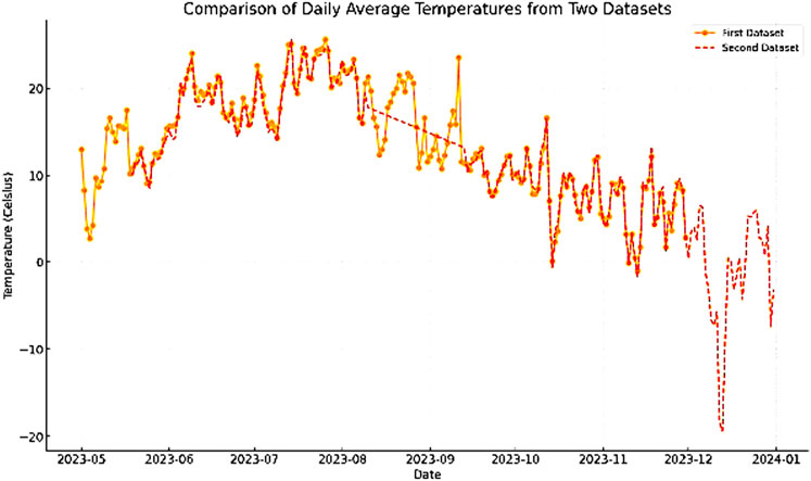
Figure 10. Comparison of temperature measurements over time from two instruments: reference weather station (solid yellow line) and the IoT weather station (dashed orange line).
9.2 Water level sensor
Figure 5 shows the water level sensor measurements from June 2023 to February 2024. These values were obtained by an ultrasonic distance meter installed below a bridge and fitted with a LoRaWAN transmitter, at about 200 m from the Baitik Gateway. The water level starts around 0.45 m in June 2023, peaks at over 0.8 m around August 2023, and then gradually decreases to around 0.4 m by February 2024. The trend shows a notable increase during the middle of 2023, followed by a steady decline towards the end of 2023 and early 2024, in accordance to the expected water level trend linked to snow melting in the spring. Again there is a gap in the data between August and September 2023 due to the above mentioned issues.
9.3 Precipitation levels
The results of the daily precipitation rate gathered at Kiz-Kuio (blue trace) and Kok-Moinok (orange trace) for the period between April 22 and May 22 are shown in Figure 11.
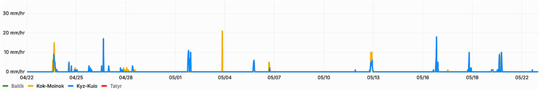
Figure 11. Daily precipitation values recorded at Kiz-Kuio and Kok-Moinok during 1 month using the IoT rain gauge.
Despite the two sites being only 12 km apart, one can notice that there are some coincidences but also significant variations. This highlights the importance of having many meteorological sensors to obtain a more accurate weather model.
9.4 Solar irradiation
Figure 12 shows the distribution of values of solar irradiation measurements. As can be observed, most measurements are in the 900 W per square meter range. Nevertheless, given the mountainous terrain involved, there are many points at much lower value. This is why we chose to standardize to a 305 Wp (peak) solar panel for all the sites, except Adygene lake that being at such a high elevation is prone to have some period of very low irradiation.
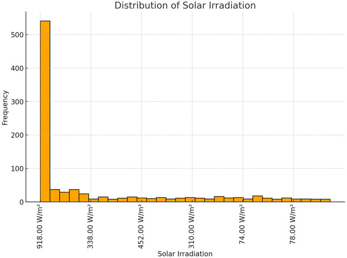
Figure 12. Distribution of solar irradiation measurements.
Referring to Figure 4, one can see that in a Summer day the peak levels of solar irradiance are similar for different sites, but there can be wide fluctuations due to clouds.
9.5 Received signal level
To assess the probability of landslides, several soil temperature and moisture sensors were installed in the Tatyr site. Figure 13 shows the variation of the received signal level over a week time. Device 2 (green trace) was buried at a depth of 100 cm, 330 m away from the gateway. Device 3 (yellow trace) was buried at a depth of 20 cm, 260 m away from the gateway. Device 5 (blue trace) was buried at a depth of 20 cm, 1,500 m away from the gateway. Notice that the strongest signal was received from Device 2, despite being buried at the deepest level. On the other hand, Device 5, which was at the longest distance, showed greater variability of the signal strength. Keep in mind that LoRa signals can be reliable decoded at signal levels as low as −137 dBm. Therefore much longer distances can be reached from the same gateway.
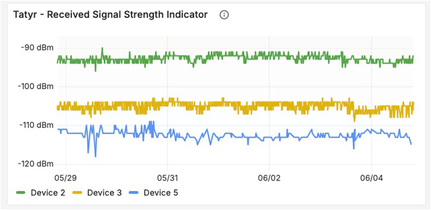
Figure 13. Distribution of solar irradiation measurements.
10 Policy Implications and Integration with climate adaptation strategies
The deployment of low-cost, LoRaWAN-enabled weather stations in Kyrgyzstan has significant potential to influence climate adaptation strategies and disaster risk reduction policies. Data collected can directly support evidence-based decision-making by local and national authorities. For instance, real-time monitoring of temperature, precipitation, and soil moisture levels offers actionable insights for managing water resources in a country heavily reliant on glacial meltwater. These insights can also inform agricultural planning, by encouraging practices that optimize resource use and minimize vulnerability to extreme weather events.
Data from the installed sensors—such as tilt sensors for landslide monitoring and river water level sensors—can be integrated into national disaster management systems, enabling timely interventions and potentially saving lives. Furthermore, this project serves as a scalable model for other mountainous or resource-constrained countries facing similar climate challenges, emphasizing the critical role of governments and international agencies in funding and supporting such initiatives. By strengthening local capacity and creating robust data-sharing frameworks, these systems could also contribute to the Sustainable Development Goals, particularly SDG 13 (Climate Action) and SDG 9 (Industry, Innovation, and Infrastructure).
The sustainability of the project benefits from close collaboration with relevant government agencies and the scientific community. In coordination with the Ministry of Emergency Situations (MES), several weather stations have been installed in disaster-prone areas. The data from the weather stations feed into the existing information systems deployed by the Ministry to monitor potential natural disasters.
The team is currently working on long-term sustainability of the project and its enhancement, both in terms of technology (application of new types of technology) and geography (installation in the wider Central Asia region). The Internet Society Foundation is considering the application for the second phase of the project. The team is also working with other donors and potential partners to establish long term cooperation in the area of disaster risk reduction through low-cost IOT/LoRaWAN weather-stations.
11 Conclusion
We have presented the planning and deployment of a wide range of wireless environmental sensors in the challenging scenario of a mountainous country. The limited Cellular coverage was addressed by deploying LoRaWAN gateways, which proved well suited to satisfy the requirements of the current application, while their agnostic nature can be leveraged to provide additional services, like messaging in places devoid of cellular coverage or for people who cannot afford the associated recurring costs. The meteorological sensors installed are less expensive than traditional automatic weather stations (AWS) without significant compromises in accuracy. The deployment of river water level, soil moisture and tilt sensors also helps in mitigating environmental disasters effects. Data are stored inside the country, thus preserving privacy, but made available to international stakeholders with legitimate interest. Several government agencies and international organizations have shown interest in deploying additional sensors of this type.
Data availability statement
The original contributions presented in the study are included in the article/supplementary material, further inquiries can be directed to the corresponding author.
Author contributions
MZ: Conceptualization, Data curation, Formal Analysis, Funding acquisition, Investigation, Methodology, Project administration, Resources, Software, Supervision, Validation, Visualization, Writing – original draft, Writing – review and editing. EP: Conceptualization, Investigation, Visualization, Writing–original draft, Writing – review and editing. AS: Conceptualization, Data curation, Formal Analysis, Funding acquisition, Investigation, Methodology, Project administration, Resources, Software, Supervision, Validation, Visualization, Writing – original draft, Writing – review and editing. TS: Conceptualization, Data curation, Formal Analysis, Funding acquisition, Investigation, Methodology, Project administration, Resources, Software, Supervision, Validation, Visualization, Writing – original draft, Writing – review and editing. BM: Conceptualization, Data curation, Formal Analysis, Funding acquisition, Investigation, Methodology, Project administration, Resources, Software, Supervision, Validation, Visualization, Writing – original draft, Writing – review and editing.
Funding
The author(s) declare that financial support was received for the research and/or publication of this article. The project has been funded by the Internet Society through the project “Creating an open and secure IoT infrastructure for monitoring and preventing emergencies in landlocked mountainous countries: the case of Kyrgyzstan”.
Acknowledgments
The authors would like to acknowledge support given by the Internet Society through the project “Creating an open and secure IoT infrastructure for monitoring and preventing emergencies in landlocked mountainous countries: the case of Kyrgyzstan”.
We also recognize the support of the following persons.
We acknowledge the use of generative AI technologies, including ChatGPT, for assistance with language editing and drafting. All intellectual contributions, research design, and final decisions in the manuscript were made by the authors.
Conflict of interest
The authors declare that the research was conducted in the absence of any commercial or financial relationships that could be construed as a potential conflict of interest.
The author(s) declared that they were an editorial board member of Frontiers, at the time of submission. This had no impact on the peer review process and the final decision.
Correction note
A correction has been made to this article. Details can be found at: 10.3389/frcmn.2025.1667265.
Generative AI statement
The authors declare that Generative AI was used in the creation of this manuscript. ChatGPS 4.
Publisher’s note
All claims expressed in this article are solely those of the authors and do not necessarily represent those of their affiliated organizations, or those of the publisher, the editors and the reviewers. Any product that may be evaluated in this article, or claim that may be made by its manufacturer, is not guaranteed or endorsed by the publisher.
Footnotes
2www.seeedstudio.com/SenseCAP-S1000-10-in-1-Compact-Weather-Station-p-5654.html?srsltid=AfmBOoruBg76u_kXSQ8o36DRRpVsgyE_eiUE8ZylEavvVtJV9vlXpc4c
3www.milesight.com/iot/product/lorawan-sensor/wts506
4metergroup.com/products/atmos-41-wireless-remote-weather-station/?utm_source = googleandutm_medium = cpcandutm_campaign = weather-monitoringandutm_content = atmos-41wandgad_source = 1&gclid = EAIaIQobChMIiL6ZlMeijAMVD6CDBx0uIDuLEAAYASAAEgKojPD_BwE.
5https://www.baranidesign.com/meteohelix-pro-weather-station
6https://re.jrc.ec.europa.eu/pvg_download/map_pdfs/G_opt_KG.jpg, and https://power.larc.nasa.gov/beta/data-access-viewer/
References
Botero-Valencia, J. S., Mejia-Herrera, M., and Pearce, J. M. (2022). Low cost climate station for smart agriculture applications with photovoltaic energy and wireless communication. HardwareX 11, e00296. doi:10.1016/j.ohx.2022.e00296
Central Asian (2024). Central asian Institute of applied geosciences. Available online at: https://www.devex.com/organizations/central-asian-institute-of-applied-geosciences-caiag-67734 (accessed on June 6, 2024).
Chae, B. G., Park, H. J., Catani, F., Simoni, A., and Berti, M. (2017). Landslide prediction, monitoring and early warning: a concise review of state-of-the-art. Geosci. J. 21, 1033–1070. doi:10.1007/s12303-017-0034-4
Disasters in numbers (2022). Disasters in numbers. Available online at: https://www.cred.be/sites/default/files/2022_EMDAT_report.pdf (accessed on June 6, 2024).
Giro, R. A., Luini, L., Riva, C. G., Pimienta-del-Valle, D., and Riera Salis, J. M. (2022). Real-time rainfall estimation using satellite signals: development and assessment of a new procedure. IEEE Trans. Instrum. Meas. 71, 1–10. doi:10.1109/TIM.2022.3165840
GSMA (2024). GSMA network coverage maps. Available online at: https://www.gsma.com/coverage/1038 (accessed on June 6, 2024).
HT-M02 (2024). HT-M02 edge LoRa gateway. Available online at: https://heltec.org/project/ht-m02-v2/ (accessed on June 6, 2024).
Huang, Z. Q., Chen, Y. C., and Wen, C. Y. (2020). Real-time weather monitoring and prediction using city buses and machine learning. Sensors (Basel) 20 (18), 5173. doi:10.3390/s20185173
KNOT (2024). KNOT LR9 kit. Available online at: https://mikrotik.com/products/group/iot-products (accessed on June 6, 2024).
Kyrgyzstan (2024). Kyrgyzstan is one of the most vulnerable countries to climate change in Central Asia. Available online at: https://www.unicef.org/kyrgyzstan/press-releases/kyrgyzstan-one-most-vulnerable-countries-climate-change-central-asia (accessed on June 6, 2024).
Kyrgyzstan ranks (2024). Kyrgyzstan ranks third most vulnerable to climate change impacts in Central Asia. Available online at: https://en.kabar.kg/news/kyrgyzstan-ranks-third-most-vulnerable-to-climate-change-impacts-in-central-asia (accessed on June 6, 2024).
Outdoor LoRaWAN (2024). 8 or 16 channel outdoor LoRaWAN gateway. Available online at: https://store.rakwireless.com/products/rak7289-8-16-channel-outdoor-lorawan-gateway?variant=42334699159750 (accessed on June 6, 2024).
Outdoor LoRaWAN® Gateway (2024). Outdoor LoRaWAN® gateway UG67. Available online at: https://www.milesight.com/iot/product/lorawan-gateway/ug67 (accessed on June 6, 2024).
Outdoor Micro Gateway (2024). Outdoor micro gateway V2. Available online at: https://www.browan.com/product/Outdoor-Micro-Gateway-V2/detail (accessed on June 6, 2024).
Papua New Guinea landslide (2024). As many as 2,000 people feared buried under Papua New Guinea landslide as survivors dig with hands and spades. Available online at: https://edition.cnn.com/2024/05/27/world/papua-new-guinea-landslide-thousands-feared-buried-intl-hnk/index.html (accessed on June 6, 2024).
SenseCAP (2024). SenseCAP outdoor gateway - LoRaWAN EU868MHz. Available online at: https://www.seeedstudio.com/LoRaWAN-Gateway-EU868-p-4305.html (accessed on 6 June 2024).
SenseCAP S2104 (2024). SenseCAP S2104 - LoRaWAN® soil moisture and temperature sensor. Available online at: https://www.seeedstudio.com/SenseCAP-S2104-LoRaWAN-Soil-Temperature-and-Moisture-Sensor-p-5357.html (accessed on June 6, 2024).
Tenzin, S., Siyang, S., Pobkrut, T., and Kerdcharoen, T. (2017). “Low cost weather station for climate-smart agriculture,” in 2017 9th international conference on knowledge and smart technology (KST), chonburi, Thailand, 172–177. doi:10.1109/KST.2017.7886085
Tilt Sensor (2024). Tilt sensor:precise angle measurement and failure prevention. Available online at: https://www.milesight.com/iot/product/lorawan-sensor/em310-tilt (accessed on June 6, 2024).
Urb-IoT (2024). Urb-IoT: LoRaWAN outdoor gateway. Available online at: https://www.iridium.com/products/urb-iot/ (accessed on June 6, 2024).
World Meteorological Organization (2024). Available online at: https://en.kabar.kg/news/kyrgyzstan-ranks-third-most-vulnerable-to-climate-change-impacts-in-central-asia (accessed on June 6, 2024).
Keywords: Kyrgyzstan, internet of things, weather stations, LORA, LoRaWAN, wireless sensor networks
Citation: Zennaro M, Pietrosemoli E, Soltobaev A, Sultanov T and Moldobekov B (2025) From mountains to data: low-cost weather stations in Kyrgyzstan’s challenging terrain. Front. Commun. Netw. 6:1505375. doi: 10.3389/frcmn.2025.1505375
Received: 02 October 2024; Accepted: 14 April 2025;
Published: 01 May 2025; Corrected: 28 August 2025.
Edited by:
Qammer H. Abbasi, University of Glasgow, United KingdomReviewed by:
Saadane Rachid, École Hassania des Travaux Publics, MoroccoJohn Richard Hizon, University of the Philippines Diliman, Philippines
Copyright © 2025 Zennaro, Pietrosemoli, Soltobaev, Sultanov and Moldobekov. This is an open-access article distributed under the terms of the Creative Commons Attribution License (CC BY). The use, distribution or reproduction in other forums is permitted, provided the original author(s) and the copyright owner(s) are credited and that the original publication in this journal is cited, in accordance with accepted academic practice. No use, distribution or reproduction is permitted which does not comply with these terms.
*Correspondence: Marco Zennaro, bXplbm5hcm9AaWN0cC5pdA==