 Matthew J. Mandich
- International Society for Archaeology, Art and Architecture of Rome (ISAR), Rome, Italy
This article investigates the urban expansion and economic development of ancient Rome through the application of models and theories originally designed for the study of contemporary cities. While the growth of ancient settlements is often difficult to track and analyze, archaeologically observable changes in land use can be read and interpreted as a function of broader economic oscillations over the longue durée. By re-examining the available archaeological and textual evidence pertaining to land use change on Rome's eastern periphery this article demonstrates how the frameworks selected can be successfully appropriated via a narration of Rome's urban transformations from the mid-Republic to the later Imperial period. The ultimate goal is to determine if the patterns of urban expansion identified in modern cities also existed in ancient Rome. The findings provided have the potential to produce rich insights on the dynamics of urban and economic growth across time and geographies, thereby opening the door for new and further studies.
Introduction
“If anyone wishes to estimate the size of Rome by looking at these suburbs he will necessarily be misled for want of a definite clue by which to determine up to what point it is still the city and where it ceases to be the city; so closely is the city connected with the country, giving the beholder the impression of a city stretching out indefinitely.”
-Dionysius of Halicarnassus,1 Roman Antiquities 4.13.4
Defining Rome's urban area was no easy task in antiquity and it remains difficult for today's archaeologists and topographers to track and determine its ancient urban extent(s). Although the mid-Republican city was demarcated by an 11 km circuit wall, constructed from circa 378–353 BC2, these fortifications should not be seen to represent Rome's true urban extent at that time since they encompassed a space (c. 427 ha) much larger than the inhabited area, likely containing swaths devoted to protected agriculture (Livy3 2.11.3, 6.32.1; Coarelli, 1988, p. 323–330). However, as the City's population grew considerably from the Fourth to First centuries BC land beyond the walls was put into use at an ever-increasing rate (Lo Cascio, 2010, p. 30–38). Certainly, by the reign of Augustus—the period in which Dionysius of Halicarnassus was active (c. 20 BC)—a denser network of buildings stretched well past the city walls forming what could today be considered somewhat of a conurbation.
This continuously built area, or continentia aedificia, as it was referred to in legal texts, already existed beyond the walls in the time of Caesar and its continued expansion presented multiple cadastral challenges (e.g., Cicero4, Ad Atticus 13.33a; Suetonius, Caesar, 44; Lex Iulia Municipalis5; Digesta6 50.16.87, 50.16.139, 50.16.147). Augustus' reorganization of Rome into 14 regions (or regiones) was designed to address many of the administrative and safety issues inherent to the expanding cityscape, including the management of extramural space (Suetonius, Augustus 30; Frezouls, 1987, p. 375). As can be seen in Figure 1, six of the 14 Augustan regiones encompassed land outside the old (Servian) city walls, seemingly in areas where building was most dense and/or conspicuous—i.e. in the Campus Martius and along certain thoroughfares to the south and east. It is often overlooked that these extramural regions had no external boundaries prior to the construction of the Aurelian Wall, begun in AD 271, and they may have been designed to grow without constraint. Indeed, as Quilici (1974) and Frezouls (1987) have observed, Augustan Rome could certainly be considered an “open city,” spreading out like “tentacles” along its numerous paved viae. Although traditional and administrative boundaries, such as the pomerium (Rome's oldest religious boundary) and the octroi (customs) boundary were also used to delimit urban and extra-urban spaces and activities, in some cases affecting the topography of the City, these borders were not designed to adapt to or keep pace with Rome's rapid expansion and should not be understood as accurate representations of its true urban extent (see Palmer, 1980; Coarelli, 1997; Andreussi, 1999; Giardina, 2000).
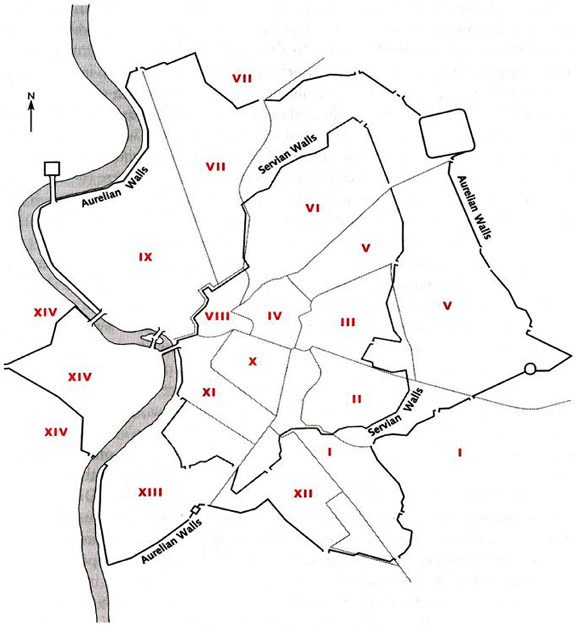
Figure 1. The 14 Augustan regions as bound by the later Aurelian Wall. Regions II (Caelimontium) and V (Esquiliae) comprise the primary area of study (Coarelli, 2014, p. 7, Figure 2 in Rome and Environs: An Archaeological Guide © 2014 by the Regents of the University of California. Published by the University of California Press (Reproduced with permission).
Instead, the rough edges of Rome's expanding, extramural built area remain the most realistic representation of its size from the late Republic through the Imperial period. Yet, because the ephemeral limits of the continentia aedificia have been difficult to locate and track, the significance of its advancement has been largely ignored. However, by taking an interdisciplinary approach, employing models and theories from urban morphology, economic geography, and complexity science, ancient Rome's urban expansion can be followed and linked to cycles of economic growth and decline. In particular, bid-rent theory, the fringe belt model, and settlement scaling theory are useful for tracking Rome's physical growth and interpreting it as a function of concomitant economic development. To demonstrate how these frameworks can be successfully applied, archaeological and textual evidence pertaining to Rome's eastern periphery is used to analyze land use patterns beyond the circuit wall from the mid-Republic (Fourth century BC) to the late Imperial period (Third century AD). How the patterns observed compare to those seen in modern settlements is key for determining if Rome was expanding (at least for a period) like a post-industrial city.
Materials and Methods
Understanding the Implications of Urban Growth: Bid-Rent Theory and Settlement Scaling Theory
The concept of rent, as defined by Ricardo (1817, p. 34–35), is the “compensation that is paid to the owner of land for the use of its original and indestructible powers”. According to Ricardo (1817, p. 34–35), rent exists “because land is not unlimited in quantity and uniform in quality”; that is, as soon as land of a more marginal quality is put into use (often due to population pressure), rent will immediately commence on land of higher quality. This concept of economic rent was central to Von Thünen (1826) seminal “Isolated State” model, which focused on the spatial distribution of agricultural practices and land use around an isolated city (i.e., market center). Although purely hypothetical, it highlighted distance-based agricultural activities, taking into account production costs, transport costs, and profit maximization to determine a more nuanced version of land rent. The resulting situation is a rent gradient in which rents decrease with distance from the market (settlement/city) as transportation costs increase, creating a series of concentric zones in which particular types of agriculture are practiced (Figure 2).
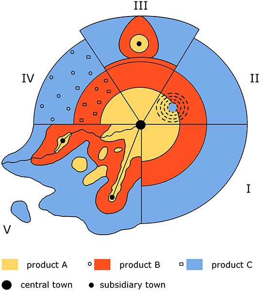
Figure 2. The Von Thünen model with multiple variables introduced. Segment I depicts the model in its undistorted (hypothetical) shape; Segment II shows how differences in the quality of soil can transpose the cultivation of certain products outside their “expected” zone; Segment III illustrates the influence of a second market; Segment IV shows the effect of peasant farmers on the model as they tend to grow products based on their personal needs rather than market principles; Segment V introduces a combination of variables including roads, rivers, minor centers, and uneven geography, which is closest to the real-world scenario (redrawn after Pred, 1967, p. 26, Figure 8.6).
Yet, how and why land uses locate in an urban setting is considerably more complex than in a rural one since space is more restricted and land is assigned to the highest bidder—i.e., the individual or institution willing to pay the most rent. Burgess (1925) was one of the first to examine land rents in an urban setting and his “concentric circle model,” which was designed to explain and predict the distribution of social groups within a city (i.e., Chicago), showed how patterns of residential land use emerged due to multiple competing factors (Figure 3). To better predict this variability, Alonso (1964) devised “bid-rent theory” to examine the location of multiple types of land use in an urban setting (e.g., commercial, residential, institutional). His theory used a detailed mathematical framework to produce “bid-rent” (or bid price) curves that vary based on the type of land use analyzed (i.e., the type of bidder), in addition to accounting for non-economic factors, such as “trade-offs.” While a simplified version of the bid-rent model indicates differing rent gradients will form concentric zones around a center, each featuring a dominant land use given the desirability of the location to the bidders (much like the Von Thünen and Burgess models) (Figure 4), Alonso's original model is much more detailed since it shows how land rents are affected by complex factors.
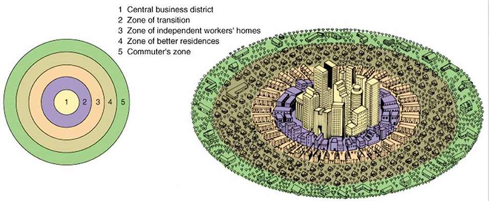
Figure 3. Graphic illustration of Burgess' concentric zone model. Nb: Zones 4 and 5 (Rubenstein, James M. The Cultural Landscape: An Introduction to Human Geography, 9th, © 2008. Reprinted by permission of Pearson Education, Inc. New York, New York).
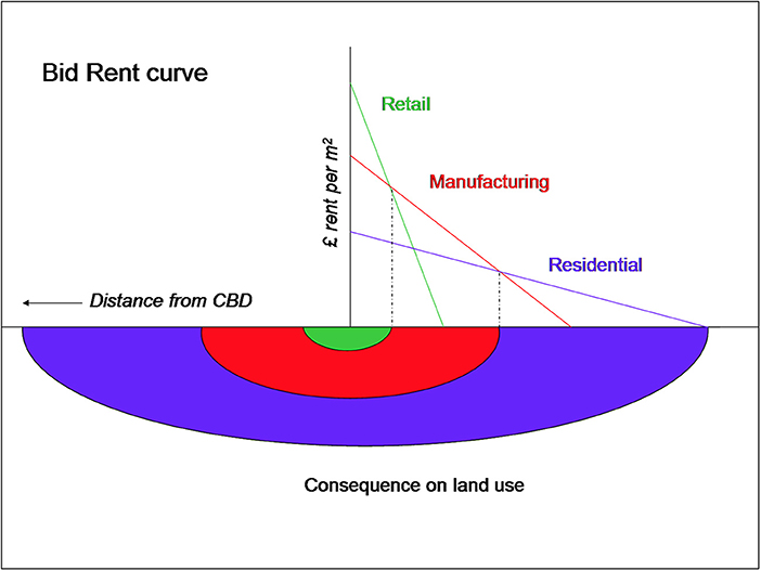
Figure 4. Simplified version of bid rent curves based on general land values (i.e., distance from city center) without complicating factors. Image illustrates three types of land uses and their bidders' willingness/ability to compete in certain zones over others. (SyntaxError55 at the English Wikipedia) [CC BY-SA 3.0 (http://creativecommons.org/licenses/by-sa/3.0/)].
For example, when analyzing residential bid-rent curves, Alonso's model illustrates how the steepness of rent gradients (and the location of property types) is affected by population growth, transport technology, and even the purchasing power of the individual (Figure 5). As the figure shows, population growth forces residential rent gradients up due to higher demand, but higher incomes lessen the steepness of residential bid-rent curves. This means that wealthier individuals tend to live on the periphery of cities because they can spread the cost of commuting over larger sites (i.e., a “trade-off”—in this case, exchanging cheaper transport costs for more space) (Alonso, 1964, p. 106–109). Improvements to transport technology should also reduce the steepness of bid rent curves more generically since they lower overall transportation costs; however, as Alonso (1964, p. 112–113) observed, such improvements make residential land prices on the periphery of cities higher (due to competition between bidders) since a reduction in transport costs allows the same level of satisfaction to be achieved at a further distance from the center on a plot with more space. As such, the vicinity of a road works to raise land values considerably, as rent gradients are both elevated near main roads and extend further along them, thereby extending the limits of the settlement (Alonso, 1964, p. 141–142) (Figure 6). In terms of economic growth, Alonso (1964, p. 114–115) concluded that periods featuring simultaneous population growth, transport innovations, and rising per capita incomes are indicative of rapid economic development, and that such a combination should result in a slower rate of outward urban expansion, leading to simultaneous densification.
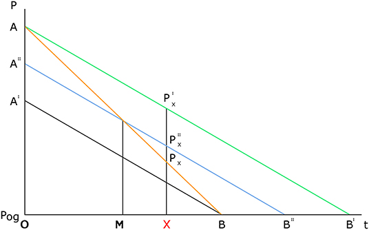
Figure 5. Effect of an improvement of transportation on the price structure: curve AB represents price structure before the transportation improvement, while curve A”B” represents price structure after the improvement. As can be seen while land prices drop closer to the city center due to these improvements, prices beyond OM increase. Thus, for an individual located at X, the price after the transport improvement (P”x) would be greater than before (Px); however, because these improvements lower both the cost and inconvenience of travel, the same (or greater) level of satisfaction is achieved despite the higher price of land, which could be seen as another type of “trade-off”. For the effect of population growth on the price structure: curve A”B” represents price structure before population increase and curve AB' represents price structure after. NB: location of X does not change but price (P) at that location does (P”x to P'x) (Alonso, 1964, p. 112, Figure 32 in Location and Land Use: Toward a General Theory of Land Rent Cambridge, Mass.: Harvard University Press, Copyright © 1964 by the President and Fellows of Harvard College. Reproduced with permission).
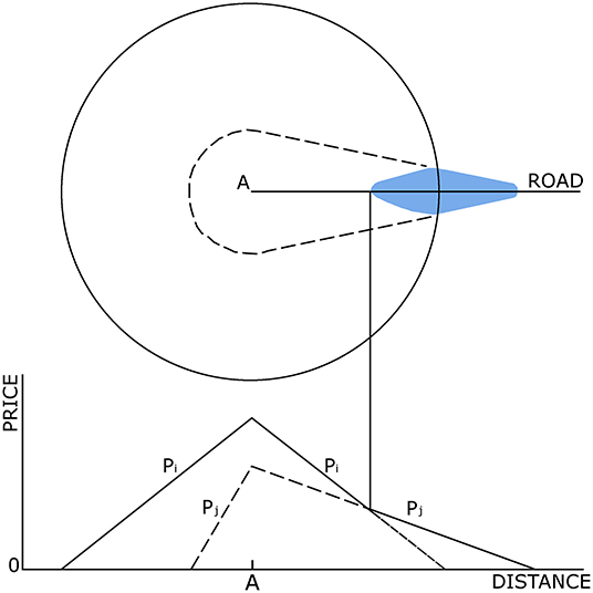
Figure 6. Rent and occupancy patterns for a city with a center and a high-status road. NB: extension of bid-rent surface beyond previous settlement “margins” (Alonso, 1964, p. 141, fig. 43 in Location and Land Use: Toward a General Theory of Land Rent Cambridge, Mass.: Harvard University Press, Copyright © 1964 by the President and Fellows of Harvard College. Reproduced with permission).
This conclusion has recently been wholly confirmed through quantitative analysis provided by the emerging framework of settlement scaling theory (SST), which plots a range of factors against urban population numbers to determine how attributes of settlements change (or scale) with settlement size. Using data obtained from modern cities, the resulting calculations have shown that as the population of a city doubles, the necessary infrastructure only increases by about 85% (i.e. β = 0.85 <1), while proxies for socio-economic activity increase by about 115% (β = 1.15>1) (Bettencourt et al., 2007). Thus, as cities grow exponentially (double in population) their infrastructure scales sub-linearly with population as a spatial economy of scale (they become denser), while their socio-economic outputs and per capita growth scale super-linearly, showing increasing returns to scale (they become more productive) (Bettencourt et al., 2007, p. 7303; Bettencourt and West, 2010, p. 912–913) (Figure 7). The existence of these scaling relationships reveals two distinct, often competing, aspects of urban growth, with one based on materials, infrastructure, and efficiency (sub-linear—economies of scale), and the other on social interactions, innovation, and wealth creation (super-linear—increasing returns to scale) (Bettencourt et al., 2007, p. 7303). While sub-linear scaling relationships are often associated with “extensive” economic growth driven by aggregate growth (i.e., more input equals more output), super-linear relationships are associated with “intensive” economic growth defined by technological innovation and/or divisions of labor that produce rising per capita income (i.e., inputs used more productively to create greater outputs) (Lal, 1998, p. 19–26).
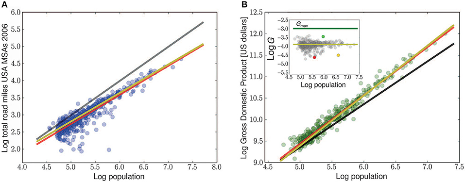
Figure 7. Examples of sub-liner (A) and super-linear (B) scaling relationships in modern cities. Black line represents linear relationship (Bettencourt, 2013a, p. 1438, Figure 1, Copyright © 2013, American Association for the Advancement of Science. Reproduced with permission).
Similar scaling relationships have been found to exist in settlement data from pre-modern contexts, including the pre-Hispanic Basin of Mexico, the Inca Empire, Medieval Europe, and the Roman Empire, indicating that these correlations should be attributed to the processes of human agglomeration rather than specific institutions or technologies (e.g., Ortman et al., 2015, 2016; Cesaretti et al., 2016; Hanson and Ortman, 2017). So far, only sub-linear scaling relationships have been found to exist in settlement data from the Roman world; however, this does not preclude the existence of super-linear relationships in a Roman context since increasing socio-economic returns should go hand in hand with demographic growth, technological innovation, and sub-linear areal expansion (i.e., increasing density and infrastructural efficiency) (see Mandich, 2016, p. 194–196). Yet because ancient settlements were sensitive to numerous exogenous and endogenous factors, often featuring complicated non-linear trajectories that differed by settlement, region, and period, a finer-grained approach that accounts for both urban growth and contraction is necessary to properly track system change over time.
Tracking Urban Expansion: The Fringe Belt Model
The fringe belt model is a morphogenetic approach used to analyze the physical and economic evolution of settlements through an examination of land use change on the urban periphery. Because this framework focuses on observable patterns of change, rather than the decision-making processes behind them, it is particularly well-suited for studying ancient settlements. How and why fringe belts form, how they can be identified (especially in the archaeological record), and how they are modified or internalized is key for understanding the processes of urban expansion and tracking the advancement of Rome's continentia aedificia. Furthermore, as fringe belt formation and modification processes are linked to economic cycles (“booms” and “troughs”), this framework is especially useful for pinpointing periods of economic growth and change.
The study of fringe belts first began in Germany, where the field of urban morphology may also be said to have originated in the late Nineteenth century. Louis (1936) was the first to recognize the existence of urban fringe belts (originally called Stadtrandzonen) in his historico-geographic study of Berlin. In this work he identified a number of land-use zones, or urban fringes, that had developed beyond urban boundaries and were later encompassed by subsequent building activities. Conzen (1969, p. 125) extended the work of Louis in England, concluding that the outward growth of the urban fringe was dictated by periods of acceleration, deceleration, and standstill associated with building booms and troughs linked to fluctuations in population, economic development, and innovation (similar to the annual growth of a tree trunk). Thus, for fringe belts to emerge, clear pulsations in urban growth tied to economic cycles are needed (Whitehand, 1987, p. 76–83; Conzen, 2009, p. 33).
Fringe belts first tend to form around clear “fixation lines,” which are often natural obstacles (e.g., rivers, hills) or defunct city walls (Conzen, 1969, p. 125; Carter and Wheatley, 1979). While it is not always easy to identify fringe belts in morphological studies of urban areas, it is achievable, since they are composed of several distinct land uses or site types, often of an extensive nature. These include, but are not limited to [list derived from Thomas (1974); Barke (1976); Conzen (2009)]:
• Open space: cemeteries, public parks, market gardens, allotments
• Institutions: religious retreats, military barracks, community buildings, hospitals, waste disposal/dumps
• Industry: warehouses, quarries, manufacturing, slaughter houses
• Residential (low density): villa/country estates, sub-standard dwellings
• Recreation: sports grounds, riding grounds, hunting/fishing areas, resorts, taverns.
As fringe belts tend to form gradually, either around a fixation line or on the edge of the halted urban periphery, the fringe belt formation stage can be broken down into several sub-phases (Conzen, 2009, p. 33–34):
• Fixation phase (incipient character associated with a fixation line)
• Expansion phase (pronounced character)
• Consolidation phase (dominant character).
The fringe belt formation stage is then followed by the modification stage, which can produce several different outcomes depending on the intensity of urban expansion occurring (Figure 8). First, the belt may be encroached upon heavily by redevelopment (predominantly for intensive residential or commercial uses) resulting in fringe belt reduction, where the fringe belt breaks apart, becoming smaller, and less coherent. Fringe belt reduction tends to occur when the core of the city (or central business district—CBD) expands, enveloping the previously formed fringe belt. This type of urban expansion is associated with the process of land use succession (a concept borrowed from Ecology), which is the tendency of an inner zone to expand in size via the “invasion” of an adjacent outer zone (Burgess, 1925, p. 50–52; Barke, 1976). Second, due to intense redevelopment, certain fringe belt activities or sites may be forced or coerced to migrate further afield in what is known as fringe belt translation. Third, the original use of the fringe belt may survive unchanged, forming a “relict” fringe belt that attracts the same or similar land uses as the built area continues to expand beyond it (see Whitehand, 1987, p. 83–93; Barke, 1990, p. 283; Conzen, 2009, p. 33–34).
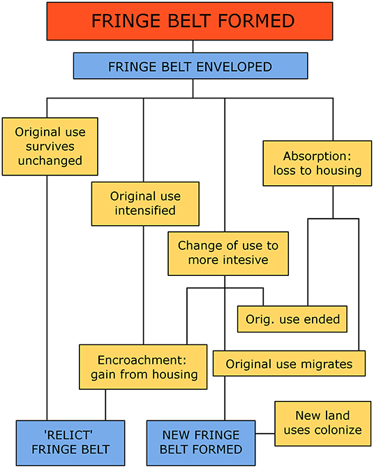
Figure 8. Fringe belt flow chart (after Conzen, 2009: Figure 2).
Recent research and empirical evidence has shown that fringe belts are a widespread morphological phenomenon, occurring across every populated continent, and at various geographical scales (Conzen, 2009, p. 35–37). This has given rise to a number of questions concerning how cultural contrasts, political power structures, and the size and age of cities affect fringe belt formation and modification, as well as how these features can be studied, modeled, and measured within a more uniform methodology (Conzen, 2009, p. 46–50). Although the fringe belt model has long been known in the fields of urban morphology and geography, archaeologists have yet to test or employ this framework on an ancient city. Thus, in the following section the fringe belt model is used to examine archaeologically detectable land use patterns from Rome's eastern periphery to determine if fringe belts existed in ancient Rome and if the same processes of urban expansion occurring in modern cities were also unfolding in the ancient world.
Results: Examining Ancient Rome's Eastern Periphery
Rome's Esquiline and Caelian hills were considered peripheral zones from an early period as they originally served as funerary areas for the budding proto-urban settlement (Ninth to Sixth centuries BC) (Albertoni, 1983; Colonna, 1996). These hills were incorporated into the settlement proper when it was divided into four regions, either under Servius Tullius or in the early Republic (Sixth to Fifth centuries BC) (Dionysus of Halicarnassus, Roman Antiquities1 4.13–14; Pais, 1905, p. 140). Following this quadripartite division a massive rampart (agger) was constructed across the Esquiline plateau (campus Viminalus and campus Esquilinus) providing Rome an eastern boundary (possibly) as early as the Sixth century BC (Cifani, 2013). Although funerary activities relocated beyond the agger following its construction (Albertoni, 1983; Cifani, 2013), the completion of a new circuit wall in the Fourth century BC (built in tufo di grotta oscura) triggered the accretion of a greater number and variety of distinct fringe belt land uses beyond this imposing fixation line.
The Middle and Late Republican Period: Fringe Belt Formation
Stratigraphic sequences from the area just outside the porta Esquilina show that this extramural zone maintained its pre-existing funerary character in the mid-Republic, as the presence of inhumation tombs with stone sarcophagi dating to the Third to Fourth centuries BC attest (Pinza, 1914, p. 144; Albertoni, 1983). The so-called “puticoli”—large (5 × 4 m), square tuff lined pits that housed the remains of poorer inhabitants in addition to serving as general waste receptacles—likely date to the Third century BC since they were cut into artificially deposited soils (or “scarichi”—dumps) containing materials from the Fourth to Third centuries BC (Lanciani, 1875, p. 191; Pinza, 1914, p. 165–169). The earliest private freestanding tombs, complete with interior frescos (e.g. “sepolcro di Q. Fabio”), are more or less in phase with these “puticoli” as they were constructed on the surface of these “dump” layers, likely in the later Third century BC (Pinza, 1914, p. 165–169; Coarelli, 1977, p. 207–208). Several rock-cut tombs (“a camera”) dating to the mid-Republican period were also discovered on the northeastern slope of the Caelian hill (via S. Stefano Rotondo) indicating the continuation of funerary activities further south (Santa Maria Scrinari, 1972).
Other fringe belt land uses were also present on the Esquiline in the mid-Republic, including religious institutions and designated open spaces, such as sacred groves, sanctuaries, and temples dedicated to the funerary deities Venus Libitina and Nenia Dea (Fraioli, 2012, p. 327–328). Additionally, extramural votive deposits, likely pertaining to the lost temple of Minerva Medica, were found near the Caelian hill, north of the porta Querquetulana (Coarelli and Ricciotti, 1977). Rome's first aqueducts, the aqua Appia (312 BC) and the anio Vetus (270 BC), also crossed the Caelian and Esquiline hills in this period, perhaps supplying water to the scared groves and/or agricultural fields located beyond the city walls (Wiseman, 1998, p. 15–16; Purcell, 2007, p. 291–294). The only literary description of what the Esquiline area might have looked like in the late Third century BC comes from Livy3 (26.10.5–6), who, writing during the Augustan age, recounts the scene of Hannibal's aborted siege during the Second Punic War (218–201 BC):
“…the consuls ordered them to make their way through the center of the city to the Esquiline, reasoning that there would be none better suited for fighting in the defiles and among the buildings of the vegetable-gardens, the tombs and the sunken lanes running in all directions”
While this description matches well with a typical fringe belt landscape, as Purcell (2007, p. 292) suggests, this account may align better with the situation of the Second or First century BC, since the area beyond the walls underwent a series of changes at this time, likely associated with the rapid growth of the City following the Punic Wars.
In particular, paved roads were constructed on both the Esquiline (“consular via”—via Labicana) and the Caelian (“via Caelimontana”) in the Second century BC, and two more aqueducts, the aqua Marcia (140s BC) and the aqua Tepula (126 BC), were built along the Esquiline's northern extent (Pinza, 1914, p. 167–169; Consalvi, 2009, p. 73). Additional freestanding, “singular” tombs also appear beyond the walls on the Esquiline and Caelian hills in this period (e.g., “tomba Arieti”) (Coarelli, 1977, p. 207; Consalvi, 2009, p. 73), while open spaces, sacred groves, and scattered institutional buildings persisted. For example, the guild of the tibicines (flute players) and the grove and sanctuary of Venus Libitina (associated with undertakers, funerals, and the Vinalia festival) remained in use at least until the late Republic (CIL VI 3823; Wiseman, 1998, p. 15). The (abusive) disposal of human remains and urban waste also continued in the early First century BC, as a line of cippi laid by the urban praetor L. Sentius beyond the agger (from the porta Viminalis to the porta Esquilina) aimed to stop the discarding of debris, carrion, and corpses within their limits (CIL VI 31614-5; Lanciani, 1898, p. 65–67; Andreussi, 1999, p. 101). However, as Cicero7 (Pro Cluentio 37) recounts in 88 BC, the area outside the porta Esquilina was not yet densely inhabited, featuring gardens and sandpits—a situation that may correspond better with Livy's description above.
As has been shown, the evolving function of this extramural landscape fits well with the sub-phases of the fringe belt formation process as the incipient character of this fringe belt, linked to a fixation line in its fixation phase, became more pronounced as it entered into the subsequent expansion phase. However, in the Second half of First century BC a new type of land use began to appear in the area that would further impact the formation of the fringe belt on Rome's eastern periphery, as Augustus' companion C. Cilnius Maecenas covered one of the aforementioned pauper burial grounds for the foundation of his famed horti Maecenatis sometime after 38 BC (Hauber, 1996, p. 73). This luxurious villa-style estate was constructed in multiple stages and sprawled over both sides of the defunct city wall, extending from the Cispian Hill to the Esquiline gate (Cima, 2008). The reclamation of the zone was famously sung about by Horace, one of Maecenas' mentees:
“Now you can live on a healthier Esquiline and stroll on the sunny Rampart (agger), where sadly you used to gaze at a grim landscape covered with whitened bones” (Horace8, Satirae 1.8).
These so-called horti were one of several such estates constructed on the Esquiline hill that comprised numerous buildings, pavilions, and parks complete with spacious dining halls, terraces, ambulatories, pools, towers, and galleries, in addition to housing the (market) gardens from which they drew their name (Vitruvius9, De Architectura 6.5.2; Pliny10, Natural History 19.49–56; Capanna, 2012). The largest of these horti were owned by wealthy families and political personalities of the late Republic (e.g., horti Lolliani, horti Lamiani), and by the end of the First century BC these expansive estates formed somewhat of a ring or “green belt” around the old city wall, with concentrations beginning to form on the Quirnal, Pincian, Esquiline, and Caelian Hills, as well is in the Campus Martius and Trastevere (Jolivet, 1997, p. 196–197; Talamo, 2008, p. 29–33; Capanna, 2012, p. 74–78) (Figure 9). The addition of these low-density residential land uses to what had become an established fringe belt consisting predominantly of open spaces (cemeteries, groves, fields, market gardens), and institutions (temples, sanctuaries, waste removal) should be understood to signal the consolidation phase of the formation process, during which the fringe belt exhibited a dominant character.
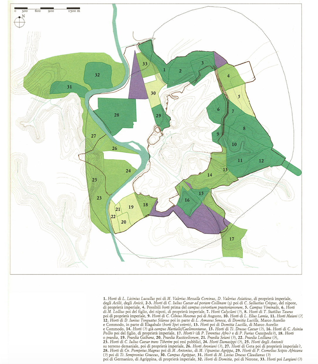
Figure 9. The horti of Rome by the Imperial period. Dark green plots represent (possible) horti created in the late Republic or Augustan period, lighter green plots represent (possible) horti created in the Imperial period, yellow-green plots represent fields, purple plots represent funerary areas (Capanna, 2012: tav. III in Carandini, A. (ed.) (2012) Atlante di Roma Antica: Biografia e Ritratti della Città. Milan: Electa © Sapienza Università di Roma. Reproduced with permission).
Interestingly, the introduction of these estates to this extramural landscape may also be interpreted as a harbinger of substantial urban expansion given the predictions of Burgess, Conzen, and Alonso. Indeed, the rapidly increasing population and progressive “monumentalizing” of the city center, already begun at the turn of the Second century BC, continued in earnest in the First century BC, especially under Caesar and Augustus, who oversaw the demolition of several residential quarters for the construction of their monumental fora, the theater of Marcellus, the Horrea Agrippiana, and the Porticus Liviae (Guidobaldi, 2000, p. 142–143; Palombi, 2016, p. 163–174; Cirone et al., 2018).
The expansion of the CBD at the cost of housing is a prime example of land use succession and such a situation would have likely contributed to the lack of intramural space and the expansion of the continentia aedificia beyond the city walls attested to by Livy3 (44.3–5) and Dionysius of Halicarnassus (Roman Antiquities1 4.13.5). In turn, the speed and intensity of the urban expansion occurring would have had a substantial impact on the fringe belt that had formed on Rome's eastern periphery.
The Imperial Period: Fringe Belt Modification
Following the formation stage, in which the fringe belt beyond the defunct city walls passed through, fixation, expansion, and consolidation phases, it would next enter the modification stage. Upon Maecenas' death in 8 BC his famous horti were bequeathed to Augustus, and while several more such estates were added to the Esquiline in the early First century AD, many passed into Imperial possession under the Julio-Claudian emperors (e.g., horti Tauriani, Pallantiani, Torquatiani), forming a large Imperial property domain in the area (Jolivet, 1997; Talamo, 2008) (see Figure 9). The presence of these sprawling low density estates, coupled with the addition of the Castra Praetoria in AD 21 (military barracks for the emperor's personal guard)—located just outside the porta Viminalis (and in front of the former agger)—further contributed to the consolidation of this fringe belt in the early Imperial period; however, scattered domus also began to appear east of the wall over the First century AD, indicating the further advancement of the continentia aedificia and the impending reduction of the pre-existing fringe belt there (Mols and Moormann, 1998, p. 127–130; Barbera et al., 2005; Colli et al., 2009; Consalvi, 2009, p. 78–79).
While the expansion of more intensive, residential land uses into this once peripheral zone was underway, it is difficult to assess how much it was either disrupted or stimulated by the fire of AD 64 (which impacted all but four of the 14 regiones). While the Caelian hill was hit hardest by the blaze, buildings at the foot of the Esquiline were also demolished “over a vast area” to quell the conflagration (Tacitus11, Annals 15.38–40). In the aftermath of the fire many of the previously haphazard quarters that defined the Republican city were entirely rebuilt under Nero (AD 54–68) in a more consciously planned manner—e.g., no shared walls, building height restrictions, wider streets, fireproof stone rather than wooden materials, and increased water infrastructure (Tacitus11, Annals 15.43). The construction of multi-family apartment buildings, or insulae (as they are commonly but erroneously referred) also augmented under Nero (in line with public services, e.g., public baths), as these four to five story buildings provided somewhat of a solution to the growing housing crisis that had its roots in the early Julio-Claudian era (Guidobaldi, 2000, p. 140–144).
However, Nero's decision to exploit the fire damage via the construction of his Domus Aurea (“golden house”) also drastically altered the topography of the City. This expansive estate, which connected the horti Maecenatis on the Esquiline to the imperial seat on the Palatine (domus Palatina), contained numerous ornate buildings and porticoes and featured a large lake (stagnum), open fields, thick woods, croplands, vineyards, and a multitude of wild and domestic animals—all in the (former) urban core (Suetonius, Nero 31, 39, 55; Tacitus11, Annals 15.42). Yet, despite Nero's ambition, this building project was short-lived and the (likely uncompleted) Domus Aurea was steadily demolished after his death and the accession of Vespasian in AD 69, who returned at least part of the land to public use via the restoration of the Temple of Claudius and the construction of the Flavian Amphitheater (or Colosseum) (Suetonius12, Vespasian 9.1). As we hear from Martial13 (Liber de Spectaculis 2), significant redevelopment had indeed occurred in the Colosseum valley and on the slopes of the abutting hills by the reign of Domitian (AD 81–96):
“Here, where the venerable mass of the far-seen Amphitheater now rises, were the ponds of Nero. Here, where we gaze with admiration at the Thermae [Baths of Titus], a boon so suddenly bestowed, a proud lawn had deprived poor wretches of their homes. Where the Claudian portico now throws its wide-spreading shadows, was the last remnant of a felling court. Rome has been restored to herself, and what were formerly the delights of the master, are now, under thy rule, Caesar [Domitian], those of the people.”
Although the Flavian reorganization of the City gave space back to the public, many of the large civic buildings, temples, and entertainment spaces were also built at the cost of housing, forcing residential, and commercial activity into new, formerly peripheral locations (Palombi, 2016, p. 80–85), thereby contributing to the reduction of the fringe belt beyond the old city walls. As Juvenal14 (Satires 5.153–155, 6.588) tells us, the remnants of the agger, once an imposing fixation line, had become a popular common area where fortunes were told (like the Circus Maximus) and a performing monkey even entertained passersby. Similarly, Quintilian15 (Inst. Or. 12.10.74), speaks of public orations taking place in the various fora and along the agger, likely in the vicinity of the extramural Macellum Liviae and the forum Esquilinum, which by that time had also become bustling commercial zones (Coarelli, 1995, p. 298; Wiseman, 1998, p. 21–22).
In the early Second century AD, the emperor Trajan (AD 98–117) continued the “monumentalization” of the city center via the construction of a massive new forum, markets, and a monumental public bath complex—the Thermae Traianae—interring the remaining Neronian and subsequent Flavian constructions on the Oppian hill (Volpe, 2016). While such building activity would have stimulated the process of land use succession, forcing residential land uses further afield, Trajan's continued break-up of the Imperial domain amassed by the Julio-Claudians (already begun under the Flavians) may have (inadvertently?) alleviated some of this pressure as several expansive imperially-owned horti were sold back to private individuals to fund the war in Dacia (Pliny the Younger16, Panegyric 50.6, 63; Talamo, 2008, p. 32). Yet, the trend of sacrificing residences closer to the center for the addition of temples and updated infrastructure continued under Hadrian (AD 117–138), and it is perhaps not surprising that the number of insulae constructed increased dramatically over the Second century AD (Guidobaldi, 2000: 146–147). By the middle of the century several of the formerly peripheral horti had also been redeveloped and subdivided into multiple domus, while domus and insulae appeared in increasing numbers outside the walls from the Porta Esquilina to the porta Caelimontana (Liverani, 1988; Mols and Moormann, 1998; Barbera et al., 2005; Cima, 2008, p. 72; Colli et al., 2009; Consalvi, 2009, p. 80).
The augmentation and densification of residences, especially on the Caelian, at greater distances from the former city walls is also notable. For example, domus from the late first and early Second centuries AD have been found under the later Lateran Basilica (Mols and Moormann, 1998, p. 123–130) while the remains of the “domus dei mosaici” and the “domus ACEA”, both located on Via Eleniana and built in the second half of Second century AD, are directly in line with the later Aurelian Wall (Barbera, 2000, p. 105; Borgia et al., 2008). Other domus constructed during the first and Second century AD were located behind the Castra Praetoria, and therefore beyond the extent of the later Aurelian Wall, while some buildings were even immured within it—e.g., a three-story insula next to the Aurelianic Porta Tiburtina and a Hadrianic marble officina near the Porta Asinaria (Pavolini et al., 2003, p. 85; Rea, 2010, p. 235–236; Dey, 2011, p. 79) (see Figure 10). It is worth noting here that the addition of military barracks (castra) by Trajan and Hadrian on the Caelian hill in the Lateran area is not at odds with this fringe belt modification phase since institutional land uses tend to locate within former fringe belts, especially if similar land uses are/were present there (e.g., campus Martialis) (see Juvenal 10.15–18; Whitehand, 1987, p. 84–85; Barke, 1990, p. 282–284; Colli et al., 2009). Regardless, the presence of residential, commercial, and institutional buildings this distance from the Republican city walls suggests that Rome's continentia aedificia had greatly advanced over the Imperial period and that the pre-existing fringe belt located there had fallen victim to the processes of fringe belt reduction, which, according to the models, should signal a period of continuous urban expansion associated with concomitant economic growth.
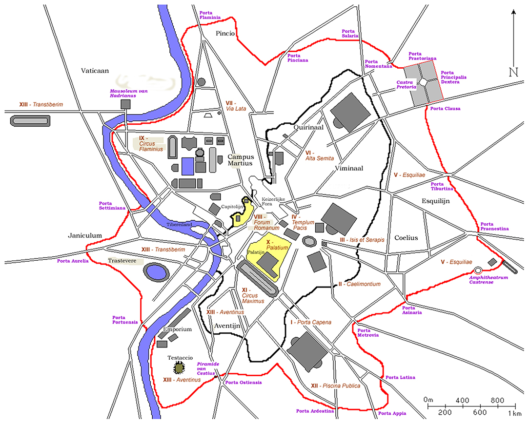
Figure 10. Map of Rome showing Republican and Aurelianic Walls. NB: Location of main roads; Porta Asinaria and Porta Tiburtina; the Castra Pretoria; and the Amphitheatrum Castrense (https://commons.wikimedia.org/wiki/File:Plan_Rome-_Aureliaanse_Muur.png) (Joris1919) [CC BY-SA 3.0 (http://creativecommons.org/licenses/by-sa/3.0/)].
The Late Empire: A New Fringe Belt Is Formed
Following a tumultuous period in Roman history in which the City was struck by the devastating Antonine plague (AD 165–180 and 189–190) which killed at least 150,000 inhabitants; another significant fire (AD 192); and a period of civil war following the assassination of the emperor Commodus (AD 193) the somewhat frenetic building and outward expansion that characterized the majority of the First and Second centuries AD began to wind down (Cassius Dio17 72.73; Guidobaldi, 2000, p. 152–153; Harper, 2017, p. 115). Although several new, monumental constructions were added to the City during the Severan dynasty (AD 193–235), including the Castra nova Equitum singularium on the Caelian hill, the Baths of Caracalla near the Porta Capena, and the Quirinal Temple, this period has been understood by Guidobaldi (2010, p. 318–322) to represent a phase of “musealizzazione” (or museum-izing), during which the entire city exhibits signs of maintenance and refurbishment after over a century of intense expansion and densification that resulted in the metropolis displayed on remnants of the Severan Forma Urbis.
In particular, the locations of the Castra nova Equitum singularium and the horti Spei Veteris (later, Sessorium palace) are important for investigating the formation of a secondary fringe belt beginning in the Severan period. Specifically, Septimius Severus' decision to build a palace complex one mile east of the porta Esquilina at the southeastern extent of the City is telling. These horti Spei Veteris—named after the nearby Fifth century BC temple of Spes Vetus—were significantly augmented by Caracalla, Elagabalus, and Alexander Severus, and comprised multiple palatial pavilions, a circus, and an amphitheater, much like the Palatine palace they were designed to mimic (Historia Augusta18, Elagabalus 13.5; Barbera, 2000). Because a construction of this magnitude required ample space and a desirable peripheral site, much like the horti of the late Republic, its location could be understood to mark the edge of the now-halted continentia aedificia (Figure 10). A closer look at the location of the Castra nova also seems to indicate the cessation of outward urban growth and the fixation of a new fringe belt at this time. Firstly, its vicinity to pre-existing military installations on the Caelian hill further confirms the presence of an earlier fringe belt there; secondly, its construction at the expense of several upper-class domus (Mols and Moormann, 1998) suggests a building trough and a general “housing slump,” likely fueled by lack of residential demand—a situation further evidenced by the diminishing construction of insulae, which eventually came to an abrupt stop by the later Severan age (Guidobaldi, 2000, p. 153; Guidobaldi, 2010, p. 322).
Following the assassination of Alexander Severus in AD 235, the conditions for the continued formation of this fringe belt were especially prevalent, as the next 36 years saw 60 attempts to capture the Imperial seat, resulting in a period of political disarray that contributed to a lack of public building and imperial investment at Rome (White, 2004, p. 27–31). In fact, by the mid-Third century AD many of the pre-existing multi story, multi-family apartment buildings (insulae) were converted into (often luxurious) single-family domus—the direct opposite to what was occurring the previous century (Guidobaldi, 2000, p. 152–154; Guidobaldi, 2010, p. 322). From AD 249-270 the Plague of Cyrpian swept through the City further damaging a population that probably never fully recovered from the prior Antonine plague (Harper, 2017, p. 136–138), and, apart from the Baths of Decius (built on the Aventine in AD 252), very few large public buildings or monuments were added to the cityscape between the Severan dynasty and the reign of Aurelian (Guidobaldi, 2010, p. 322–323).
The construction of the Aurelian Wall, begun in AD 271, can then be seen to formerly conclude the previously unchecked urban expansion of the City; however, an examination of its course and composition can shed further light on the formation of a fringe belt during the Third century AD. To begin, roughly one sixth of the Aurelianic circuit is comprised of pre-existing structures and many more were demolished or buried to make way for both an external ditch (fossa) and an internal access road (intervallum) (Lanciani, 1892, p. 106; Dey, 2011, p. 165–166). The variety of sites revealed by excavations around the wall is striking, as both private and imperially owned (and procured) properties (often referred to as villas or horti in Nineteenth century documentation) were impacted by its construction (Lanciani, 1892, p. 104–110; Richmond, 1930, p. 11–16). Starting in the north, several estates from the mid-Imperial period near the Castra Praetoria were dissected by the wall and then abandoned, as were other domus built in the first to Second century AD located beyond the castra, past the Wall's extent (Lanciani, 1892, p. 104–106; Pavolini et al., 2003, p. 85; Guidobaldi, 2010, p. 316). On the east, a decorative garden nymphaeum complete with colored pumice, shells, and statuary niches (with intact statues) was absorbed by the circuit near the porta Tiburtina along with several larger tombs in the same area (Lanciani, 1892, p. 104, 109). Moving south, the Wall notably cut through part of the Severan horti Spei Veteris (located near the porta Praenestina), incorporating the amphitheatrum Castrense but leaving the majority of the circus Varianus outside its limits (Richmond, 1930, p. 16; Barbera, 2000). Still further south, the recent discovery of a quarry and small farm near the porta Asinaria also attest to characteristic fringe belt activities in the area (Rea, 2010, p. 232–238).
Given this information, it appears that a pre-existing fringe belt was exploited for the construction of the Wall since its course attempted, where possible, to follow a path of least resistance, cutting through peripheral estates, funerary zones, and less densely built plots to more quickly (but roughly) fortify the City on its eastern side. Although the course of the Aurelianic circuit was influenced by the presence of the tax border, pomerium, and other practical, geographic, and militaristic considerations (see Palmer, 1980; Coarelli, 1997; Dey, 2011, p. 72–86), its relatively star-shaped perimeter encompassed areas of significant urban expansion that followed major thoroughfares and aqueducts beyond the Republican city walls, matching well with the predictions of bid rent theory and highlighting the dynamic physical expansion of the City over the period in question (Mandich, 2015, p. 85–92). Yet, because the course of the Wall seems to have cut through an established fringe belt, leaving certain quarters outside its limits, the circuit should not be viewed as the quintessential maximum extent of ancient Rome, but rather as a sort of “cookie-cutter” that separated the most densely urbanized areas from the more extensive urban development that had spread uninhibited into the immediate countryside—once giving Dionysius the impression of “a city stretching out indefinitely.” While the construction of the Aurelian Wall can be understood to mark a period of contraction and consolidation, it also gave the City a clear, physical urban extent, providing a new fixation line that served to restart many of the complex morphological processes that had slowly played out over the previous six and a half centuries.
A Glance to the Suburbs: Fringe Belt Translation
To more fully understand the processes of urban expansion and economic development occurring in ancient Rome, a brief look at sites in its immediate surroundings is required. Although mid-Republican villas are often elusive in the archaeological record, evidence from the suburbs does attest to a network of productive villas surrounding the City and taking advantage of the economic situation created by its growth and vicinity (De Neeve, 1984; Carandini, 1985; Morley, 1996, p. 55–63). In particular, properties on the Centocelle plain (4th mile of the via Labicana) and in the eastern environs were engaged in agricultural production (often viticulture and poly-culture) and consisted of farmhouses (typically built in opus quadratum and/or opus incertum) surrounded by fields and demarcated by ditches, banks, and/or roads (fossae or rivi finales), each holding about 50–70 iugera (12–18 hectares) (Musco and Zaccagni, 1985, p. 91–106; Volpe, 2004, p. 448–455; Volpe, 2008, p. 262–263). According to Volpe (2000, p. 186), the construction of these mid-Republican villas represents a period of change in which a previous, more autonomous, domestic system mutated, as villas began to reorient around Rome due to the increasing urban demand for agricultural goods (likely in accordance with the predictions of Von Thünen's model).
In the later Republic, many of these earlier villas were augmented (or obliterated and rebuilt, frequently in opus reticulatum) via the addition of more luxurious residential quarters, porticos, and ornamental garden spaces—often at the expense of areas previously dedicated to agriculture (Volpe, 2008, p. 262–267; Volpe, 2009, p. 381). In some cases this could signal the reinvestment of profits by villa owners engaged in successful agricultural practices; however, it seems more likely that these properties now belonged to a new class of owner as the value of such estates would have increased considerably in line with the physical and demographic growth of the City (see Figure 5). In fact, many more villas were constructed in this period overall as 71 of the 100 villas considered by De Franceschini (2005, p. 297) in her book Ville Dell'agro Romano were built ex novo between the Second century BC and the Augustan era, with 50 constructed specifically between the later First century BC and the early First century AD—indicating an influx of people and wealth into the countryside that coincided with a period of rapid urban expansion.
Over the First century AD the presence of imported wine amphorae in both urban and suburban contexts also escalated dramatically (Volpe, 2009, p. 380–381). While this is often linked to a variety of factors, including a growing urban population and a shifting market, it also reflects a more densely settled hinterland that had shifted in the late Republic from extensive agriculture (such as viticulture/poly-culture) to intensive practices, primarily for the urban markets—e.g., horticulture (fruits, vegetables, herbs), pastio vilactica (rearing of small animals and birds), and the cultivation of flowers and plants for garlands and dyes (in hortensia) (Carandini, 1985; Patterson, 1987; Witcher, 2006; Volpe, 2009). Although vines were probably still widely cultivated on suburban properties during the Imperial period, wine was likely produced in smaller quantities of higher quality (e.g., the famed vite Nomentana) and transported/stored in barrels, making it archaeologically undetectable, explaining both the absence of Italian amphorae and the augmentation of provincial imports (De Sena, 2005, p. 6; Volpe, 2009, p. 280–281).
Such a situation would suggest that land in Rome's immediate suburbs had become more expensive due to increasing demand, in turn, leading to a denser landscape of monumental villas that included more expansive residential quarters, ornate interior décor, large cisterns, and grandiose bath complexes (De Franceschini, 2005, p. 304–314; Volpe, 2007, p. 395–398). Indeed, by the mid-Imperial period villas on the Centocelle plain were now situated c. 700 m from each other with each one likely belonging to a different owner (Volpe, 2000, p. 204) (Figure 11). As Coarelli (1986, p. 54) has suggested, by this time these properties had probably come to function as primary residences (or domus) for their owners given the nearby viae and the outward expansion of the City that provided them a more peripheral location. In fact, the presence of high-end villa estates near major roads and aqueducts matches well with the predictions of bid-rent theory since infrastructural amenities work to steepen residential bid rent curves in their vicinity, making such properties more expensive (Alonso, 1964, p. 110, 141–142) (Figure 6). As such, it is perhaps not surprising that many estates in the eastern suburbs were either owned by senators, often of provincial origin, or connected to members of the Imperial family (see Pliny the Younger19, Ep. 6.9.1–6; Coarelli, 1986, p. 41–55).
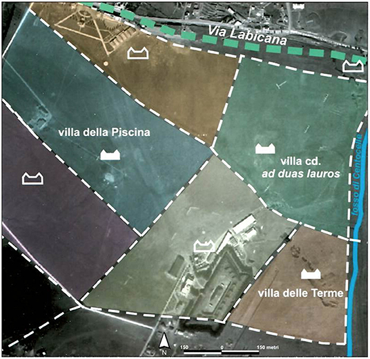
Figure 11. Centocelle plain: hypothetical size of villa plots in the Imperial period (Volpe, 2007 (ed): 397, Figure 3 in Volpe (2007) (ed) Centocelle II. Roma SDO. Le indagini archeologiche. Soveria Mannelli: Rubbettino. Used with permission).
While these estates still maintained profitable agricultural components, the architectural and functional changes observed should be directly linked to Rome's urban expansion and the processes of land use succession and fringe belt reduction and translation. Since the former fringe belt on the Esquiline and Caelian Hills was heavily reduced by a steadily advancing continentia aedificia over the First and Second centuries AD, certain land uses may have translated further afield (see Figure 8). Specifically, previously peripheral low-density estates (such as the horti) would have been forced to migrate to a new peripheral location, while the conversion of many domus into insulae over the course of the Second century AD could be related to the relocation of these single-family home owners to more removed suburban estates (Jolivet, 1997, p. 201–203; Guidobaldi, 2010, p. 321–322).
Because the translation of a fringe belt is often associated with the presence of another further removed fixation line, the conversion of primarily productive properties into more luxurious residential estates around the fourth to sixth mile markers of Rome's major viae is of particular interest since this location marked the extent of Rome's fabled ager Romanus antiquus. Although debates concerning the antiquity and existence of this enigmatic perimeter continue, this distance did hold a juridical, practical, and memorial significance into the Imperial period (see Strabo20, Geography 5.3.2; Appian21, Civil Wars 1.23, 1.57; Smith, 2017), possibly contributing to a perceived discontinuity in the countryside that provided a potential fixation line around which such residences could conglomerate.
Turning to the Third century AD, despite Rome's damaged population elite competition remained strong in the environs. The construction of an aqueduct, widely attributed to Alexander Severus, running rather irregularly (and clearly off the path of previous aqueducts) through this eastern zone should signal the continued importance of properties there, many of which were now owned by the Imperial family, either through inheritance, or confiscation (Coarelli, 1986, p. 51, 56–58). Examining the sites of the Centocelle plain, the so-called “villa delle terme” shows evidence for significant investment into the bath complex in the Second and Thrid centuries AD, while the so-called “villa delle piscine” exhibits a similar pattern of upgrades (Coletti, 2007, p. 201–213; Volpe, 2007, p. 399–400). In the area of Torre Spaccata (2 km east of Centocelle), “villa A 204” was redeveloped in the early Third century AD, as two arae for grain macination and a torcular (wine/oil press) were demolished and paved over with marble opus sectile floors, indicating the expansion of the pars urbana at the expense of the pars rustica (Ciceroni, 2008, p. 211–214). Although elite investment continued at certain pre-existing sites over the Third century AD, as is expected during an economic “trough,” almost no new villas were constructed in Rome's suburbs at this time and the number of villas abandoned rose considerably, especially following the construction of the Aurelian Wall (De Franceschini, 2005, p. 297).
Discussion
A re-examination of the available evidence from ancient Rome's eastern periphery has shown that the processes of fringe belt formation, modification, and translation were unfolding in ancient Rome much as they would in a contemporary urban setting. The increasing number of distinct fringe belt land uses appearing beyond the defunct city walls over the Republican period points to the formation of a fringe belt that experienced fixation, expansion, and consolidation phases. The subsequent expansion of public, civic, and commercial land uses in the city center during the Imperial period would have then forced the relocation of certain land use activities, and the changing function of residential plots on the City's expanding periphery—from horti to domus to insulae—matches well with the predictions of bid-rent theory and the process of land use succession. This could suggest that the outward expansion of the City was linked to a combination of increasing population, innovations in transport technology, and (possibly) rising per capita incomes, which, when combined, should represent phases of substantial economic growth. As the city continued to expand outward over the Imperial period many primarily productive villas were transformed into upper-class residential estates as land values would have elevated, especially near roads and aqueducts where bid rent curves steepened. However, following the Antonine plague, and a period of political turmoil, the advancement of the continentia aedificia slowed dramatically as a new fringe belt began to form on the edge of halted urban periphery, reflecting a building slump associated with a period of overall economic stagnation.
Using the theoretical framework of settlement scaling theory, it appears that the same correlations found between population, infrastructure, area, and socio-economic outputs in modern cities also appear to have been at play in ancient Rome, although this has yet to be confirmed empirically. Apart from the archaeological evidence presented above, the ancient sources also suggest that densification was occurring over the period of study. For example, Livy3 (21.62) mentions that multi-story buildings already existed in 218 BC, while more general accounts of Rome's Republican urban fabric speak to a jumbled maze of streets and (often poorly built) high-rise structures (Livy3 5.55, 40.5; Tacitus11, Annals 15.38–43). In the Mid-First century BC the construction of multi-story residences increased (Vitruvius9, De Architectura 2.8.17), and following the Augustan reforms, and a period of peace and stability ushered in by the new monarchy, the building, sale, and remodeling of houses apparently became “unceasing” (Strabo, Geography20 5.3.235). The proliferation of insulae over the First to Second centuries AD also points to continued densification in the Imperial period, and despite attempts to maintain a more controlled brand of urban development following the fire of AD 64, 10 story buildings remained prevalent (Juvenal14 Satires 3.407-8). In addition, data from modern cities has shown that for each doubling of the population, land rents (i.e., bid-rent curves) rise by 50% (Bettencourt, 2013b, p. 6)—a statistic that may lend some credence to the statement of Juvenal (Satirae 3.320-5), who rather jokingly recounts that, in the late First century AD, for the price to rent a dark attic for a year in Rome one could buy a house with a garden in Sora or Frusino (towns south of the City).
While it remains difficult to confirm the existence of super linear scaling relationships and increasing socio-economic returns in a Roman context via quantifiable data, the patterns of urban growth observed fit well with the expected theoretical outcomes predicted by settlement scaling theory and the social reactor model. As periods featuring simultaneous population growth, technological change, transport innovations, and urban densification did occur over the period of study, the theoretical frameworks employed would also suggest periods of concomitant intensive economic growth (see Mandich, 2016). The fact that the house of M. Lepidus was considered the most beautiful in Rome in 78 BC, but could not find a place within the 100 most beautiful homes in the City 35 years later, is certainly worth pause:
“Let a person, if he will, in taking this fact into consideration, only calculate the vast masses of marble, the productions of painters, the regal treasures that must have been expended, in bringing these hundred mansions to vie with one that had been in its day [78 BC] the most sumptuous and the most celebrated in all the City; and then let him reflect how that, since that period [43 BC], and down to the present time [c. AD 77], these [100] houses have all been surpassed by others without number” (Pliny, Natural History 36.110).
In sum, Rome's expansion fits well with the principles and predictions of bid rent theory, the fringe belt model, and settlement scaling theory. The successful application of these models has allowed to view the physical growth of the city as a new dataset to examine economic development in the Roman period. Furthermore, if the same or similar processes driving the physical growth of contemporary cities were occurring in ancient Rome, it can be argued that ancient Rome was growing and evolving much like a modern metropolis. If correct, this allows for the urban growth of ancient and modern settlements to be linked regardless of temporal or technological differentiations, illustrating the continuity of human settlement dynamics, and providing different ways to analyze and interpret urban growth, decline, and economic development in the ancient world (see Mandich, forthcoming).
Author Contributions
The research and writing for this paper was all undertaken by MM.
Funding
This paper was funded via an OPEN-AIRE grant to Dr. Francesca Fulminante through the University of Rome (Marie Curie Sklodowska Fellowship 628818- Past-People-Nets 2014–2016).
Conflict of Interest
The author declares that the research was conducted in the absence of any commercial or financial relationships that could be construed as a potential conflict of interest.
Acknowledgments
This paper was published thanks to an OPEN-AIRE fellowship granted to Francesca Fulminante for the Marie Slodowska Curie Project 628818 Past-People-Nets. Special thanks are owed to Francesca Fulminante and the other members of the editorial committee for inviting me to contribute to this Special Issue and for funding the publication of this research. Many thanks are also owed to the Reviewers for their constructive comments.
Footnotes
1. ^Dionysius of Halicarnassus (Translated by E. Cary 1937–50) Roman Antiquities. London: Harvard University Press.
2. ^As the chronological scope of this paper runs from the mid-Republic to the later Imperial period the debate surrounding the existence, course, and date of the earlier Archaic wall circuit is not fully considered here.
3. ^Livy (Translated by B. O. Foster 1919) Ab Urbe Condita. London: Heinemann.
4. ^Cicero (Translated by H. G. Hodge 1927) Ad Atticus. London: Harvard University press.
5. ^Lex Iulia Municipalis (Translated by A. C. Johnson, P. R. Coleman-Norton, F. C. Bourne, C. Pharr 1961). Austin: University of Texas Press.
6. ^Digesta (Translated by P. Kruegar and T. Mommsen, 1967–73). Berlin: Weidmann.
7. ^Cicero (Translated by H. G. Hodge 1927) Pro Cluentio. London: Harvard University press.
8. ^Horace (Translated by H. R. Fairclough 1926) Satirae. London: Harvard University Press.
9. ^Vitruvius (Translated by C. Saliou 2009) De Architectura. Paris: Les Belles Lettres (Collection des Universités de France).
10. ^Pliny the Elder (Translated by W. H. S. Jones, H. Rackham and E. D. Eichholz 1938–62). Naturalis Historia. London: Harvard University Press.
11. ^Tacitus (Translated by J. Jackson and C. H. Moore 1931–37) Annales. London: Harvard University Press.
12. ^Suetonius (Translated by J. C. Rolfe 1914) De Vita Caesarum. London: Harvard University Press.
13. ^Martial (Translated by D. R. Shackleton Bailey 1993) Liber de Spectaculis. London: Harvard University Press.
14. ^Juvenal (Translated by S. M. Braund 2004) Satirae. London: Harvard University Press.
15. ^Quintilian (Translated by D. A. Russell 2002) Institutio Oratoria. London: Harvard University Press.
16. ^Pliny the Younger (Translated by B. Radice 1969) Panegyricus. London: Harvard University Press.
17. ^Cassius Dio (Translated by E. Cary 1914–27) Roman History. London: Harvard University press.
18. ^Historia Augusta (Translated by D. Magie 1921). London: Harvard University Press.
19. ^Pliny the Younger (Translated by B. Radice 1963) Epistulae. London: Penguin.
20. ^Strabo (Translated by H. W. Jones 1917–32) Geography. London: Harvard University Press.
21. ^Appian (Translated by H. White 1912–13) Civil Wars. London: Harvard University Press.
References
Albertoni, M. (1983). La necropoli Esquilina arcaica e repubblicana. In: L'archeologia in Roma capitale tra Sterro e Scavo. Roma Capitale 1870-1911, eds G. Pisani Sartorio and L. Quilici (Venice: Masilio Editore, 140–155.
Alonso, W. (1964). Location and Land Use: Toward a General Theory of Land Rent. Cambridge: Harvard University Press.
Andreussi, M. (1999). “Pomerium,” in Lexicon Topographicum Urbis Romae IV, ed E. M. Steinby (Rome: Edizioni Quasar, 96–105.
Barbera, M. (2000). “Dagli Horti Spei Veteris al Palatium Sessorianum,” in Aurea Roma: Dalla Città Pagana alla Città Cristiana, eds S. Ensoli and E. La Rocca (Rome: L'Erma di Bretschneider, 104–112.
Barbera, M., Palladino, S., and Paterna, C. (2005). La domus dei Valerii a Roma. The Journal of Fasti Online. Rome: Associazione Internazionale di Archeologia Classica. Available online at: http://www.fastionline.org/docs/FOLDER-it-2005-47.pdf
Barke, M. (1990). “Morphogenesis, fringe belts and urban size: An exploratory essay,” in The Built Form of Western Cities, ed T. R. Slater (Leicester: Leicester University Press, 279–299.
Bettencourt, L. (2013a). The origins of scaling in cities. Science 340, 1438–1441. doi: 10.1126/science.1235823
Bettencourt, L., Lobo, J., Helbing, D., Kühnert, C., and West, G. (2007). Growth, innovation, scaling, and the pace of life in cities. Proc. Natl. Acad. Sci. U.S.A 104, 7301–7306. doi: 10.1073/pnas.0610172104
Bettencourt, L., and West, G. (2010). A unified theory of urban living. Nature 467, 912–913. doi: 10.1038/467912a
Borgia, E., Colli, D., Palladino, S., and Paterna, C. (2008). Horti spei Veteris e Palatium Sessorianum parte II. The Journal of Fasti Online. Rome: Associazione Internazionale di Archeologia Classica.
Burgess, E. W. (1925). “The growth of the city,” in eds R. E. Park and E. W. Burgess (Chicago, IL: University of Chicago Press, 47–62.
Capanna, M. C. (2012). “Gli horti,” in Atlante di Roma Antica: Biografia e Ritratti della Città, ed A. Carandini (Milan: Electa, 74–78.
Carandini, A. (1985). “Orti e frutteti intorno a Roma,” in Misurare la Terra: Centuriazione e Coloni nel Mondo Romano. Città, Agricoltura e Commercio: Materiale da Roma e dal Suburbio, eds R. Bussi, and V. Vandelli (Modena: Edizioni Panini, 66–74.
Carter, H., and Wheatley, S. (1979). Fixation lines and fringe belts, land uses and social areas: nineteenth-century change in the small town. Transac. Inst. Br. Geogr. 4, 214–238.
Cesaretti, R., Lobo, J., Bettencourt, L. M. A., Ortman, S. G., and Smith, M. E. (2016). Population-area relationship for medieval european cities. PLoS ONE 11:e0162678. doi: 10.1371/journal.pone.0162678
Ciceroni, M. (2008). “La Villa A 204,” in Torre Spaccata. Roma S.D.O. Le indagini Archeologiche, ed P. Gioia (Roma: Soveria Mannelli), 173–241.
Cifani, G. (2013). Considerazioni sulle mura arcaiche e repubblicane a Roma. Scienze dell'Antichità 2, 204–208.
Cima, M. (2008). “Gli horti dell'Esquilino,” in Gli Horti di Roma Antica, eds M. Cima and E. Talamo (Milan: Mondadori Electa, 63–105.
Cirone, D., De Cristofaro, A., Di Mento, M., and Bertoldi, T. (2018). Signum Vortumni Project. Rapporto Preliminare Sulla Prima Campagna di Scavi Negli Horrea Agrippiana (2016). Rome: Associazione Internazionale di Archeologia Classica.
Coarelli, F. (1977). “Frammento di affresco dall'esquilino con scena storica,” in Roma Medio Repubblicana: Aspetti culturali di Roma e del Lazio nei secoli IV e III a.C, ed R. Benedetto (Rome: L'Erma di Bretschneider, 200–208.
Coarelli, F. (1986). “L'Urbs e il suburbio,” in Societa' Romana e Impero Tardoantico, ed A. Giardina (Roma: Politica, Economia, Paesaggio Urbano; Editori Laterza, 1–58.
Coarelli, F. (1988). “Demografia et territorio,” in Storia di Roma I. Roma in Italia, eds A. Momigliano and A. Schiavone (Turin: Guilio Einaudi Editore, 317–339.
Coarelli, F. (1995). “Forum Esquilinum,” in Lexicon Topographicum Urbis Romae II, ed E. M. Steinby (Rome: Edizioni Quasar), 258.
Coarelli, F. (1997). “La consistenza della città nel periodo imperiale: Pomerium, vici, insulae,” in La Rome impériale: Démographie et Logistique. Actes de la Table Ronde (Rome: École Française de Rome), 89–109.
Coarelli, F. (2014). Rome and Environs. An Archaeological Guide. Oakland, CA: University of California Press.
Coarelli, F., and Ricciotti, D. (1977). “Stipe di Minerva Medica,” in Roma Medio Repubblicana: Aspetti culturali di Roma e del Lazio nei secoli IV e III a.C, ed R. Benedetto (Rome: L'Erma di Bretschneider, 147–148.
Coletti, C. M. (2007). “La villa delle terme: L'impianto termale,” in Centocelle II, Roma S.D.O Le Indagini Archeologiche, ed R. Volpe (Rome: Rubbettino Editore, 201–215.
Colli, D., Martines, M., and Palladino, S. (2009). Roma. Viale Manzoni, Via Emanuele Filiberto. L'ammodernamento Della Linea A Della Metropolitana: Nuovi Spunti Per la Conoscenza della Topografia Antica. Rome: Associazione Internazionale di Archeologia Classica.
Colonna, G. (1996). “Roma arcaica, I suoi sepolcreti e le vie per I Colli Albani,” in Alba Longa: Mito, Storia, Archeologia, ed A. Pasqualini (Rome: Istituto Italiano per la Storia Antica, 335–354.
Consalvi, F. (2009). Il Celio Orientale: Contributi Alla Carta Archeologica di Roma, Tavola VI settore H. Rome: Quasar.
Conzen, M. P. (2009). How cities internalize their former urban fringes: a cross cultural comparison. J. Urban Morphol. 13, 29–54.
Conzen, M. R. G. (1969). Alnwick, Northumberland: A Study in Town-Plan Analysis. Publications, Institute of British Geographers, 27 2nd Edn. London: George Philip.
De Sena, E. (2005). “An assessment of wine and oil production in Rome's hinterland: ceramic, literary, art historical and modern evidence,” in Roman Villas around the Urbs. Interaction with Landscape and Environment. Proceedings of a Conference at the Swedish Institute in Rome, eds B. Frizell and A. Klynne (Rome). Available online at: http://www.isvroma.it/public/New/index.php?option=com_content&view=article&id=106:roman-villas-around-the-urbs-interaction-with-landscape-and-environment&catid=40:on-line-publikationer&Itemid=106
Dey, H. W. (2011). The Aurelian Wall and the Refashioning of Imperial Rome, AD 271-855. Cambridge: Cambridge University Press.
Fraioli, F. (2012). “Esquiliae,” in Atlante di Roma Antica: Biografia e Ritratti della Città, ed A. Carandini (Milan: Electa, 323–341.
Frezouls, E. (1987). “Rome ville ouverte. Réflexions sur les problèmes de l'expansion urbaine d'Auguste à Aurélien,” in L'Urbs: Espace Urbain Et Histoire (Ier siècle av. J.-C. - IIIe siècle ap. J.-C.). Actes du Colloque International de Rome (8-12 mai 1985) (Rome: École Française de Rome), 373–392.
Guidobaldi, F. (2000). “Le abitazioni private e l'urbanistica,” in Roma Antica, ed A. Giardina (Bari: Editori Laterza, 133–162.
Guidobaldi, F. (2010). “Architettura e urbanistica: dalla citta-museo alla citta santa,” in Roma Imperiale. Una Metropoli Antica, ed E. Lo Cascio (Rome: Carocci editore, 315–352.
Hanson, J. W., and Ortman, S. G. (2017). A systematic method for estimating the populations of Greek and Roman settlements. J. Roman Archaeol. 30, 301–324. doi: 10.1017/S1047759400074134
Harper, K. (2017). The Fate of Rome: Climate, Disease, and the End of an Empire. Princeton: Princeton University Press.
Hauber, C. (1996). “Horti Maecenatis,” in Lexicon Topographicum Urbis Romae III, ed E. M. Steinby (Rome: Edizioni Quasar, 70–74.
Jolivet, V. (1997). “Croissance urbaine et espaces verts à Rome,” in La Rome Impériale: Démographie et Logistique Actes de la Table Ronde (Rome, 25 mars 1994) (Rome: École Française de Rome), 193–205.
Lal, D. (1998). Unintended Consequences: The Impact of Factor Endowments, Culture and Politics on Long-Run Economic Performance. Cambridge, MA: MIT Press.
Lanciani, R. (1875). “Decreto edilizio intorno il sepolcreto esquilino,” in BullCom, III (Rome: Coi Tipi del Salviucci)190–203, Tav. XIX-XX.
Liverani, P. (1988). Le proprietà Private Nell'area Lateranense fino all'età di Costantino. Mélanges de l'Ecole Française de Rome. Antiquité 100, 891–915.
Lo Cascio, E. (2010). “Populazione,” in Roma Imperiale. Una Metropoli Antica, ed E. Lo Cascio (Rome: Carocci editore, 17–70.
Louis, H. (1936). “Die geographische Gliederung von Gross-Berlin,” Landerkundliche Forschung: Krebs-festschrift, eds H. Louis and W. Panzer (Stuttgart: Engelhorn, 146–171.
Mandich, M. J. (2015). “Re-defining the Roman ‘suburbium' from Republic to Empire: A Theoretical Approach,” in TRAC 2014: Proceedings of the Twenty-Fourth Annual Theoretical Roman Archaeology Conference, eds T. Brindle, M. Allen, E. Durham, and A. Smith (Oxford: Oxbow Books, 81–99.
Mandich, M. J. (2016). “Urban scaling and the growth of Rome,” in TRAC 2015: Proceedings of the 25th Annual Theoretical Roman Archaeology Conference, eds M. J. Mandich, S. Gonzalez Sanchez, E. Zampieri, G. Savani, and T.J. Derrick (Oxford: Oxbow Books), p. 188–203.
Mols, S., and Moormann, E. (1998). “Le pitture romane – frammenti e resti in situ,” in Laterano 1 – Scavi sotto la Basilica di S. Giovanni in Laterano- I Materiali, eds P. Liverani, S.T. Mols, E. M. Moormann, G. Spinola (Vatican City: Musei Vaticani, 115–131.
Morley, N. (1996). Metropolis and Hinterland: The City of Rome and the Italian Economy, 200 B.C.-A.D. 200. Cambridge: Cambridge University Press.
Musco, S., and Zaccagni, P. (1985). “Le ville nel settore Nord-est del suburbio,” in Misurare la Terra: Centuriazione e Coloni nel Mondo Romano. Citta', Agricoltura e Commercio: Materiale da Roma e dal Suburbio, eds R. Bussi, V. Vandelli (Modena: Edizioni Panini, 83–98.
Ortman, S. G., Cabaniss, A. H. F., Sturm, J. O., and Bettencourt, L. M. A. (2015). Settlement scaling and increasing returns in an ancient society. Sci. Adv. 1:e1400066. doi: 10.1126/sciadv.1400066
Ortman, S. G., Davis, K. E., Lobo, J., Smith, M. E., Bettencourt, L. M. A., and Trumbo, A. (2016). Settlement scaling and economic change in the Central Andes. J. Archaeol. Sci. 73, 94–106. doi: 10.1016/j.jas.2016.07.012
Palmer, R. E. A. (1980). “Customs on market goods imported into the city of Rome,” in Memoirs of the American Academy in Rome, Vol. 36, The Seaborne Commerce of Ancient Rome: Studies in Archaeology and History (Ann Arbor, MI: University of Michigan Press), 217–233.
Palombi, D. (2016). I Fori Prima dei Fori: Storia Urbana dei Quartieri di Roma Antica Cancellati per la Realizzazione Dei Fori Imperiali. Rome: Edizioni Espera.
Patterson, J. R. (1987). Crisis: what crisis? Rural change and urban development in imperial Apennine Italy. Pap. Br. Sch. Rome 55, 115–146.
Pavolini, C., Dinuzzi, S., Cupito, C., and Fusco, U. (2003). “Fra Tevere, Aniene, e via Nomentana,” in Suburbium: Il Suburbio di Roma dalla Crisi del Sistema delle Ville a Gregorio Magno, eds P. Pergola, R. Santangeli Valenzani and R. Volpe (Rome: École Française de Rome), 47–95.
Pred, A. (1967). Behavior and Location. Foundations for a Geographic and Dynamic Location Theory. Lund: C.W.K. Gleerup.
Purcell, N. (2007). “The horti of Rome and the landscape of property,” in Res bene gestae: Ricerche di Storia Urbana su Roma antica in Onore di Eva Margaret Steinby, eds A. Leone, D. Palombi, and S. Walker (Rome: Edizione Quasar, 362–378.
Rea, R. (2010). “Indagini archeologiche 1999-2009 lungo le Mura aureliane. Da via Casilina Vecchia a Porta Metronia. L'evoluzione del paesaggio,” in Bollettino d'Arte Volume Speciale: Archeologia e Infrastrutture, Il Tracciato Fondmentale della Linea C della Metroplitana di Roma: Prime Indagini Archeologiche, eds R. Egidi, F. Filippi, and S. Martone (Florence: Casa Editrice Leo S. Olschki, 221–242.
Santa Maria Scrinari, V. (1972). Tombe a camera sotto via S. Stefano Rotundo presso l'ospedale di S. Giovanni in Laterano. BullCom LXXXI, 17–24.
Talamo, E. (2008). “Sviluppo e cronologia degli horti,” in Gli Horti di Roma Antica, eds M. Cima and E. Talamo (Milan: Mondadori Electa), 28–33.
Thomas, D. (1974). “The urban fringe: approaches and attitudes,” in Suburban Growth, Geographical Processes at the Edge of the Western City, ed. J. H. Johnson (London: John Wiley and Sons), 17–30.
Volpe, R. (2004). “Lo sfruttamento agricolo e le costruzioni sul pianura di Centocelle in età repubblicana,” in Centocelle I. Roma S.D.O. Le Indagini Archeologiche, eds P. Gioia and R. Volpe (Roma: Soveria Mannelli), 447–462.
Volpe, R. (2007). “L'utilizzazione del pianura di Centocelle in età imperiale,” in Centocelle II. Roma SDO. Le indagini archeologiche, ed. R. Volpe (Roma: Soveria Mannelli), 389–407.
Volpe, R. (2008). “Occupazione e utilizzazione del territorio in età romana,” in Torre Spaccata. Roma S.D.O. Le indagini archeologiche, ed. P. Gioia (Roma: Soveria Mannelli), 259–272.
Volpe, R. (2009). “Vino, vigneti ed anfore in Roma Repubblicana,” in Suburbium II, Il Suburbio di Roma dalla Fine dell'età Monarchica alla Nascita del Sistema delle Ville (V-II secolo a.C.), eds V. Jolivet, C. Pavolini, M. A. Tomei, and R. Volpe (Rome: École Française de Rome), 369–381.
Volpe, R. (2016). Before and below the Baths of Trajan (Rome). MAAR 61, 59–75. Available online at: https://www.jstor.org/stable/44988073
White, J. (2004). Restorer of the World: The Roman Emperor Aurelian. Stapelhurst: Spellmount Publishers.
Whitehand, J. W. R. (1987). The Changing Face of Cities: A Study of Development Cycles and Urban Form. Oxford: Blackwell.
Wiseman, T. P. (1998). “A walk on the rampart,” in Horti Romani. Atti di Convengo Internazionale. Roma 4-6 maggio 1995, eds M. Cima. and E. La Rocca (Rome: L'Erma di Bretschneider, 13–22.
Keywords: Rome, Roman archaeology, Roman topography, economic geography, fringe belts, location theory, settlement scaling theory
Citation: Mandich MJ (2019) Ancient City, Universal Growth? Exploring Urban Expansion and Economic Development on Rome's Eastern Periphery. Front. Digit. Humanit. 6:18. doi: 10.3389/fdigh.2019.00018
Received: 15 December 2018; Accepted: 21 November 2019;
Published: 10 December 2019.
Edited by:
Francesca Fulminante, University of Bristol, United KingdomReviewed by:
Teresa Stoppani, Architectural Association School of Architecture, United KingdomNic Terrenato, University of Michigan, United States
Penelope J. E. Davies, University of Texas at Austin, United States
Copyright © 2019 Mandich. This is an open-access article distributed under the terms of the Creative Commons Attribution License (CC BY). The use, distribution or reproduction in other forums is permitted, provided the original author(s) and the copyright owner(s) are credited and that the original publication in this journal is cited, in accordance with accepted academic practice. No use, distribution or reproduction is permitted which does not comply with these terms.
*Correspondence: Matthew J. Mandich, bWF0dGhldy5tYW5kaWNoQGdtYWlsLmNvbQ==