Abstract
This study analyzes the archaeological record of Arenal Central, a Guaraní residential site on Martín García Island within the Río de la Plata estuary, situated in the southernmost region colonized by these Amazonian populations. It presents data on technology, subsistence, procurement networks, catchment areas, stylistic behaviors, and chronology, providing five new radiocarbon dates that make this site the best-dated Guaraní context in the region, and the second Guaraní residential base analyzed for this area. The results are integrated with previously known data to examine key aspects of Guaraní colonization, including chronology, subsistence strategies, resource acquisition, hunting ranges, and settlement spatial distribution, contributing to a new synthesis of Guaraní archaeology at the southernmost extent of their expansion in South America. Finally, the findings are contextualized within the broader framework of human occupations in insular settings.
1 Introduction
Originating in the southern Amazon Basin, Guaraní society expanded across southeastern South America, covering more than 1,500 km from southern Brazil to the Río de la Plata estuary in Argentina, likely following the Uruguay River as their main southward migration route, facilitated by canoe-borne mobility within a tropical and subtropical riparian forest environment that provided ideal conditions for the construction of their ecological niche (Figure 1 and Section 2) (Brochado, 1984, 1989; Schmitz, 1991; Noelli, 1999–2000; Bonomo et al., 2015; Gascue and Bortolotto, 2016; Noelli and Correa, 2016; López Mazz and López Cabral, 2020; Loponte et al., 2025, among others). Accordingly, the archaeological record of Arenal Central stands out as the southernmost known settlement along this axis, located in the inner estuary of the Río de la Plata. The site's relative insularity, located on a small island, and its unique ecological setting—where tropical forests meet Chaco and Pampas-like environments—make it an important case study for exploring cultural variability as Guaraní groups adapted to environments beyond their traditional tropical and subtropical habitats.
Figure 1

Location of Martín García Island in the Río de la Plata Estuary. The inset map broadly illustrates the southward expansion of the Guaraní population from southwestern Amazonia to the Río de la Plata region. The area corresponding to Martín García Island is indicated by a red square.
This study addresses three interrelated objectives centered on this frontier context. First, it analyzes the material record and associated practices of Guaraní forager-horticulturalists at Arenal Central. As only the second investigation of a Guaraní residential base in the region—complementing previous work at Arroyo Fredes (Section 2)—the site provides significant insights into lifeways and human–environment interactions at the southern margin of their expansion. The second objective is to examine the colonization process of the region by these Amazonian populations, contributing to wider perspectives on their migratory process. Finally, we briefly situate the findings within broader debates in island archaeology.
To achieve these objectives, we begin by describing the site, emphasizing key aspects of its stratigraphy, formation processes, chronological data, and the composition of the archaeological record. We then examine the chronology and spatial distribution of Guaraní sites in the region to provide a regional comparative framework and to outline the main patterns of Guaraní colonization in the area. Finally, we integrate these findings into broader interpretive models concerning human occupation of island environments.
2 Archaeological background
The Guaraní archaeological record reflects the material culture and behavioral patterns associated with Amazonian forager-horticulturalists who migrated from southwestern Amazonia to the Plata Basin during the Late Holocene pre-Columbian period (Brochado, 1973, 1984, 1989; Noelli, 1999–2000; Schmitz, 1991, among others)1. Their subsistence relied on hunting, fishing, gathering, and cultivating crops such as maize, tropical tubers, beans, squash, and peanuts, among others. These groups also practiced ritual anthropophagy (Ramírez [1528] in Madero, 1939; Fernández de Oviedo y Valdés [1526–1557], 1945; Schmidl [1536–1554], 1948). Although the chronology, geographic extent, and cultural processes associated with the emergence of these assemblages in southwestern Amazonia remain uncertain, it is worth noting that some stylistic features characteristic of their pottery and other artifacts appear to have been present in that region as early as 2000 BCE (Almeida, 2013; Caldarelli, 2008; Miller, 2009; Zimpel, 2009, 2018, among others). Therefore, it is accurate to state that the Guaraní expansion—explicitly referred to as such—originated in southwestern Amazonia, as illustrated by the inset map in Figure 1 (see also Brochado, 1973, 1984; Zimpel, 2009, 2018).
Guaraní archaeological assemblages are well-defined by consistent associations of material culture traits and specific practices. Pottery is especially distinctive, including corrugated and polychrome vessels with emblematic geometric motifs—mainly in red, orange, brown, and black—often applied over white slips. Vessel typologies are highly standardized, correlating with functional and emic categories. The assemblage also features characteristic ornaments such as T-shaped quartz labrets, gourd-shaped pendants, bone and stone earrings, and clay pipes. Common tools include square, neckless axes and whetstones, likely used for maintenance and crafting. Mortuary practices involved both primary and secondary burials, often in urns, with or without grave goods, reflecting broader Amazonian traditions. The lithic assemblages are dominated by small flakes of microcrystalline rocks (Ambrosetti, 1895; Alí et al., 2017; Brochado, 1973, 1984; Brochado and Monticelli, 1994; Buc, 2017; Capparelli, 2014; Carbonera, 2014; Carbonera and Loponte, 2024; Carbonera et al., 2021; La Salvia and Brochado, 1989; Lothrop, 1932; Maldonado Bruzzone, 1931; Mazza et al., 2016; Milheira, 2014; Müller and de Souza, 2011; Musali, 2010a; Novasco et al., 2021; Noelli, 1993, 1999–2000; Pérez and Alí, 2017; Prous, 2010; Prous and Lima, 2008; Rogge, 1996; Schmitz, 1991, 2008; Schneider et al., 2024a,b; Sempé and Caggiano, 1995; Silvestre and Capparelli, 2017, among many others).
In the La Plata Basin, the earliest Guaraní sites date to around 500 ± 100 CE, corresponding to settlements located along the Upper Paraná River. From these areas, the Guaraní expanded eastward, reaching the Atlantic coast of southern Brazil around 800–1000 CE, and the Paraná Delta and Río de la Plata estuary between 1229 and 1423 CE, coinciding with their maximum territorial extent (Figure 1) (see updated synthesis in Loponte et al., 2025). This expansion appears to have been driven by the colonization of new territories by founder populations with low demographic densities, establishing new settlement areas while leaving intermediate zones uncolonized, likely inhabited by pre-existing populations. These new population centers gradually expanded by saturating adjacent areas and establishing new zones of colonization beyond the catchment areas already in use, thereby reproducing the same cycle.
Archaeological research on Guaraní sites in the Río de la Plata estuary and Paraná Delta has a long, though limited, academic tradition. These studies began with the work of Outes (1917), based on a few materials recovered by Antonio Pozzi from the Puerto Viejo site on Martín García Island, and from Arroyo Largo in the Paraná Delta, unsystematically collected by Enrique de Carles (Outes, 1918). In the first half of the 20th century, additional surface collections and limited interventions were carried out by local museum curators and amateur collectors (e.g., Vignati, 1936; Bonomo et al., 2009; Pazzi, 2021; Torino and Bonomo, 2024). During this period, curators from the Museo de La Plata recovered human remains from the Arroyo Fredes and Arroyo Malo sites (Vignati, 1941), which were recently analyzed with a focus on mortuary practices and diet (Loponte et al., 2016; Mazza et al., 2016).
Excavations at Guaraní sites in the region conducted in accordance with modern academic standards began in the 1930s with Lothrop's (1932) investigations at Arroyo Malo. These initial studies offered valuable insights into the burial patterns observed at the site, along with examples of material culture recovered from the excavated area, which appears to have been used almost exclusively for funerary purposes.
Subsequent efforts included limited fieldwork conducted by Cigliano (1968) at the El Arbolito site on Martín García Island and by Caggiano (1982) at the Paraná Guazú 3 site in the Paraná Delta. Both researchers published only limited results from their investigations, including a radiocarbon age for the El Arbolito site, marking the first such date obtained for a Guaraní site in the area, which remained the sole radiocarbon determination until 2003–2005 (see below).
In the 21st century, research activities resumed with systematic excavations by Loponte and Acosta (2003–2005) at the Arroyo Fredes site (Paraná Delta) and by Capparelli (2014) at Arenal Central on Martín García Island. These recent projects represent systematic investigations of well-preserved Guaraní residential areas, generating a substantial body of new data and providing fresh perspectives on previously unexplored aspects of Guaraní archaeology in the region regarding material culture, funerary patterns, chronology, biological markers of activity, subsistence and mobility (Acosta and Mucciolo, 2009; Acosta et al., 2010, 2019; Alí et al., 2017; Capparelli, 2014, 2019; Buc, 2017; Buc et al., 2014; Loponte et al., 2011b; Mazza et al., 2016; Musali, 2010a; Pérez and Alí, 2017; Pérez et al., 2009, 2018; Silvestre and Buc, 2015; Silvestre and Capparelli, 2017).
Additionally, recent years have seen the unsystematic collection of Guaraní materials from heavily impacted sites such as Kirpach and Rincón de Milberg (Loponte and Capparelli, 2013, and unpublished data), as well as the discovery of what appear to be, for now, isolated burials on an island located along El Duraznito creek in the Paraná Delta (unpublished data). Starting in 2023, new research activities were initiated, introducing new topics for local Guaraní archaeology based on previously collected materials, along with the reevaluation of sites identified during the early stages of investigation, such as Arroyo Malo, Arroyo Largo, and Arroyo Fredes all located in the Paraná Delta (unpublished data). This new phase, driven by the incorporation of new researchers and funding resources, enables renewed efforts in excavation and analysis, marking a significant step forward in the development of Guaraní archaeology in the area, of which this work is a part.
3 Environmental settings
3.1 Geology and geomorphology
Describing the island's geomorphological and environmental characteristics is essential, as these are poorly documented in the archaeological literature and key for contextualizing this study.
Martín García is a small rocky island with a surface area of ~2 km2 and a maximum elevation of about 28 meters. It is located in the upper estuary of the Río de la Plata, near the mouth of the Uruguay River, and is separated from the mainland by the 3.5 km-wide Canal del Infierno channel, across which lies the Martín Chico area in the Eastern Republic of Uruguay (Figure 1). The island is an outcrop of the Precambrian crystalline basement, known as the Martín García igneous-metamorphic complex, mainly composed of granitoids, schists, orthogneisses, migmatites, ultrabasic rocks, and amphibolites. Among these, amphibolites—characterized by their granular texture and varying shades of green—are the most widespread rock type on the island (Dalla Salda, 1981; Benítez, 2023). In the central and northern sector, where the terrain forms a gentle plain, the bedrock is mostly covered by Quaternary sediments. However, in the southern area, with its more elevated and rugged topography, the bedrock emerges in narrow rocky strips that extend toward the southern and southeastern beaches, which are covered with blocks and clasts detached and eroded by fluvial activity (Figure 2).
Figure 2

Southern beach of Martín García Island, covered with clasts and boulders. Photograph shows four of the authors of this study (legal statement by the authors).
Across most of the island, the igneous-metamorphic complex is unconformably overlain by marine sediments known as “Unit A” (Ravizza, 1982), containing gravel ranging from sand to pebbles, predominantly composed of quartz, along with estuarine and marine gastropods and bivalves. Some profiles also display calcareous concretions. Unit A has been radiocarbon-dated to 19,050 ± 500 years 14C BP (Ravizza, 1982). Following this, continental aeolian silts of Pleistocene age (Unit B) were deposited, with thicknesses reaching up to 5 meters. Above these silts lies a 90 cm-thick sand layer corresponding to deposits from a mid-Holocene marine ingression (Unit C), dated to 5,740 ± 130 years 14C BP (Ravizza, 1982). Extensive accumulations of loose, unconsolidated sand, designated as Unit D, overlie Unit C. These deposits are particularly prominent in the central and western sectors of the island, forming the “Arenal Central” (~“Central sandbank”) of Martín García. Although the origin of these sands remains uncertain, they may be linked to significant floods of the Uruguay River (Ravizza, 1982). Based on its stratigraphic position, Unit D is assigned to the Late Holocene (<3,500 years BP).
The geomorphological configuration of the island has changed significantly over recent decades due to sediment transport and progradation, resulting in the formation of an extensive sedimentary area attached to its northern end, which began to emerge in the 1980s. This same process has filled the old bay located west of the Arenal Central, where the Puerto Viejo area is situated, and has also initiated the formation of a new sedimentary island just west of Martín García (Figure 3). This progradation process has also substantially reduced the distance between Martín García Island and the Paraná Delta, bringing them to just a few kilometers apart today. However, during the Guaraní occupation, the advancing front of the lower Delta was likely situated farther northwest, possibly 25 to 30 kilometers from its current position (Figure 3 and Section 7.3).
Figure 3

Map (A) Location of Martín García Island in relation to recently formed sedimentary islands of the upper estuary of the Río de la Plata and the successive advancing fronts of the Paraná Delta, as documented in existing historical cartography (adapted and modified from Medina and Codignotto, 2013). (B) Martín García Island (light green) alongside sedimentary islands to the north, west and south that emerged during the 20th century. (C) Detail of the original silhouette of Martín García Island, shown in light-dark green, with the sedimentary deposits attached to its northern and western sectors depicted in brown.
3.2 Environment
Martín García Island has a warm-temperate climate influenced by the subtropical regime of the Uruguay River, which extends these conditions into the upper estuary of the Río de la Plata. It is part of the Paraná wetland, a region dominated by wetlands and subtropical fluvial environments, including the islands of the Paraná Delta, adjacent continental floodplains, and the fluvial banks of the Uruguay and Paraná rivers. Ecologically, while the region is primarily dominated by tropical and subtropical species, it also exhibits significant influences from the adjacent Chaco-Pampean plains, which encompass temperate environments hosting both humid-temperate and xerophytic species. The latter vegetation grows particularly on coastal ridges left by the ingressive and regressive processes of the sea during the Holocene and on fluvial banks formed by loose sands that remained beyond the regular flood pulses (Burkart et al., 1999; Cabrera and Zardini, 1978).
Martín García Island exemplifies this complex interplay of ecosystems, reflecting the diversity and transitions between these distinct ecological zones. Along the beach-adjacent areas of the island, riparian forests thrive, featuring woody species such as Salix humboldtiana and Erythrina crista-galli, and several tree-like shrubs, such as Sesbania punicea and Senna corymbose adapted to subtropical environments and capable of withstanding brief periods of flooding. A short distance inland a denser forest emerges, representing a degraded extension of the Upper Paraná Atlantic Forest (also called “Paranaense Forest”; cf. Cabrera and Zardini, 1978). This multistratified forest canopy includes species such as Rapanea sp., Ocotea acutifolia, Eugenia uruguayensis, and Syagrus romanzoffiana. Beneath the canopy grow shrubs, bamboo species, and lianas, with a moss layer covering much of the forest floor. This formation is denser than the riparian forest, allowing significantly less light to reach the ground. Both forest types are found at elevations below 4–6 meters above sea level, forming a ring around the island's terrain. It is worth noting that oceanic storms, which have a significant influence on the entire estuary, can raise water levels up to 3.6 meters, flooding areas below this altitude. Above this elevation, covering the island's interior, a savanna environment and a xerophytic forest characteristic of the Tala District develops (Arturi and Juárez, 1997). This forest includes species such as Scutia buxifolia, Celtis tala, and Jodina rhombifolia (Arturi and Juárez, 1997), along with various cacti and shrubs that thrive in the sandy, porous soils of Units C and D. Areas where species from these three forest formations intermingle are common, and it is not unusual to find subtropical species growing within the xerophytic forest area. Based on the current distribution of plant communities, soil types, and the relationship between altitude and vegetation types on the island (e.g., Arturi and Juárez, 1997), it can be inferred that much of the island was covered by a tropical-subtropical forest assemblage, while its interior was occupied by small open areas interspersed with patches of xerophytic forest (Figure 4).
Figure 4
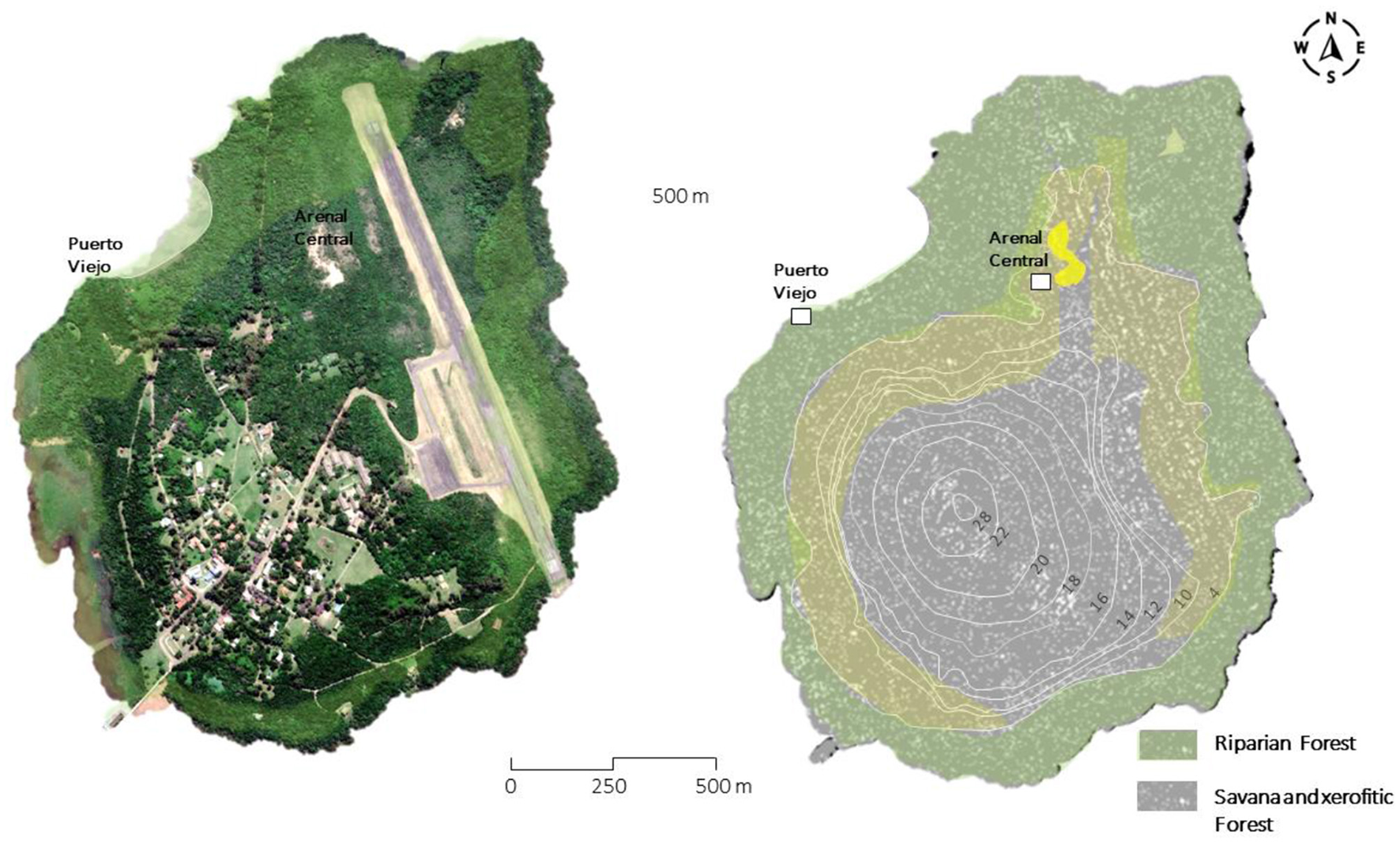
Left: Satellite image of Martín García Island with the Guaraní sites Puerto Viejo and Arenal Central. Right: Hypothetical distribution of plant communities during the Guaraní occupation, based on present-day vegetation and elevation. Overlapping colors mark the intersection of marginal and xerophytic forests. Riparian forest includes the marginal forest. This representation, developed for this study, uses topographic data derived from Dalla Salda (1981). See other representations in Loponte et al. (2011a) and Capparelli (2019).
No pre-Guaraní occupations have been identified on the island to date. It is highly likely that, prior to the Guaraní occupation, the island hosted small populations of mammals typical of the region, such as Blastocerus dichotomus (marsh deer), Myocastor coypus (coypu), and Hydrochoerus hydrochaeris (capybara). The latter two species are excellent swimmers and adept colonizers of insular and aquatic environments, while the marsh deer is also capable of swimming, albeit over shorter distances. Notably, during the 2023 excavations, an individual of this species reached the island by swimming. Species like these might also arrive at Martín García on floating islands of vegetation, which are common during major floods. Such floating vegetation accumulations are frequently carried by the Paraná and Uruguay rivers and often transport both small and large animals. However, the larger resident fauna was likely rapidly exploited and driven to extinction following the onset of Guaraní colonization, due to the small size of island and the pressures arising from resource extraction by a Guaraní village, which typically comprised dozens or even hundreds of people.
In contrast, the availability of fish resources around Martín García is remarkably abundant. The upper estuary serves as a natural extension of the fish populations from the Uruguay and Paraná rivers, where over 150 species have been documented—many of them large, exhibiting notable aggregation and migratory patterns that had a significant impact on local pre-Columbian subsistence strategies (Loponte, 2008; Musali, 2010b). Just 3.5 km across the Del Infierno Channel, on the Uruguayan mainland, lies a strip of riparian forest up to 1 km wide in the Martín Chico area. This forest then transitions into open grasslands, which during pre-Columbian times were home to characteristic species such as Rhea americana (greater rhea), Ozotoceros bezoarticus (pampas deer), and dasypodids (armadillo species). In the central and southern sectors, the island features soils suitable for cultivation, which have been used for this purpose from historical times to the present, although today they are represented mainly by small garden plots.
3.3 Location of the Arenal Central archaeological site
Arenal Central is situated on a gently sloping plain with xerophytic vegetation, spanning the central-northern sector of Martín García Island at elevations around 4–6 m above sea level (Figure 4). The surface is covered by sand from Unit D, both loose and stabilized by vegetation, extending across the open dune field and the surrounding xerophytic forest (Figure 5). While the exact center of the site remains unknown, the excavation area featured in this study is located at latitude −34.180595° and longitude −58.250637° (±2 m) (Figure 6; see also Section 5).
Figure 5

(A) Aerial view looking northeast from the excavation area, showing the end of the Arenal Central dune field, the northern tip of the airstrip, and, beyond the Del Infierno Channel, the coastline of the Martín Chico area. (B) Aerial view looking east, with the excavated area from the 2023 season outlined in white. In the background, the airstrip and the Río de la Plata are visible. (C) Ground-level view of the xerophytic forest environment surrounding the 2023 excavation area. (D) Photographic documentation of the first layer in grid 2. Photograph shows two of the authors of this study (legal statement by the authors).
Figure 6

Top: Location of the 2023 excavations (white area labeled “A”) in relation to previous excavations shown in light blue (approximately located after Capparelli, 2019: 83). Bottom: Stratigraphy of Grids 1 and 2. D1 = slightly compacted loose sand with organic material; D2 = black archaeological layer, slightly compacted; D3 = yellow loose sand, with a somewhat compacted and slightly darkened top.
4 Previous archaeological work on Martín García Island
The first archaeological study on the island was conducted by Outes (1917), who published findings of a few Guaraní pottery fragments and human skeletal remains from funerary urns recovered by technicians from the former National Museum of Natural History of Buenos Aires in the Puerto Viejo area (see Figure 4 for the location). In subsequent years, minor interventions were carried out, including one by Vignati (1936). Decades later, Cigliano (1968) excavated “El Arbolito,” imprecisely located somewhere in the northern section of the airstrip, recovering a small collection of Guaraní pottery. Cigliano obtained a radiocarbon date of 405 ± 35 14C years BP (GrN-1456), aligning with the Arenal Central chronology (Section 6.1). Given the island's size, it is likely that “El Arbolito” and Arenal Central are different areas of a single Guaraní settlement at the northern end of the airstrip.
More recently, Capparelli (2014, 2019) conducted excavations at Arenal Central, covering ~80 m2 across 17 excavation units. She recovered 2,248 ceramic fragments, a small assemblage of lithic and bone artifacts, and faunal remains. Based on the last comprehensive study of this researcher, ceramic analysis revealed that plain sherds (n = 962) and corrugated sherds (n = 761) represent 43 and 34% respectively of the total assemblage, followed by fingernail printed (n = 242; 10%) and painted (n = 283; 13%). Of the 283 painted sherds, all are red monochrome except for six, which exhibit polychromy. Of these six fragments classified as polychrome, Capparelli included five from Cigliano's previous excavation at the El Arbolito site (Capparelli, 2019: 103–104). Thus, only one polychrome fragment was recovered during her excavation.
Reconstructed forms from this collection include corrugated closed-profile pots, likely designed for cooking, small vessels intended for serving food, and large containers probably used for storage, reflecting a wide range of domestic activities. Thin-section analysis of ceramic fragments from this collection revealed that the pastes contained various lithic fragments and large ground sherds as inclusions, which are typical of Guaraní pottery (Pérez et al., 2009, 2018; Capparelli, 2014, 2019; Carbonera and Loponte, 2020; Bertoncello et al., 2024).
The analysis of starch grains and phytoliths on ceramic sherds recovered from the controlled excavation context conducted by Capparelli allowed the identification of Zea mays, Phaseolus vulgaris, and Cucurbita sp., three taxa that were widely cultivated by the Guaraní (Capparelli and Vázquez, 2022). The lithic assemblage includes sharp flakes made from cryptocrystalline and silicified limestones, most of which were produced using the bipolar technique. Additionally, slightly modified local pebbles and clasts, shaped through polishing, were identified (Silvestre and Capparelli, 2017; Pérez et al., 2018). The faunal assemblage (360 NISP) primarily consists of bony fish species typical of the estuarine environment, along with mammals associated with the island's riverine-lacustrine habitats and the adjacent plains (Capparelli, 2014, 2019). A more detailed analysis of these findings is provided in Section 6.3.
A radiocarbon date obtained from a charcoal sample from Quadrat 3, Level 4, yielded an age of 410 ± 40 14C years BP (LP-2543) (Capparelli, 2014, 2019). This age closely aligns with the one reported by Cigliano (1968). Further details about the site's chronology are discussed in Section 6.1.
5 The 2023 field season
Approximately 7.4 m2 were excavated at Arenal Central during the 2023 field season, distributed between Grid 1 (2.4 m2) and Grid 2 (5 m2). The latter was subdivided into smaller sectors (Figure 6). The geographic coordinates of both quadrats are presented in UTM format and reproduced in the sketch in Figure 6, with a margin of error of ± 2 meters. The placement of the grids was determined by the results of 13 test pits conducted in a 100-square-meter area, the condition of the topsoil, and the distribution of vegetation. Since the site is located within a natural preservation area, relatively open spaces were selected for the test pits to minimize vegetation removal, which also influenced the placement, shape, and orientation of the grids. Test pits 6 and 13 yielded positive results, producing a significant quantity of material and exposing dark sediments rich in charcoal fragments. In contrast, the other test pits yielded negative results, with sediments showing only a slight dark staining and few or no archaeological findings. This discontinuous distribution of the archaeological record is typical of Guaraní sites and correlates with the spatial arrangement of residential units within villages (Carbonera, 2014; Brochado, 1984; Goulart, 1987; Métraux, 1948; Rogge, 1996; Schneider et al., 2024b).
The archaeological materials from the grids were uncovered through careful scraping of the sediment, as it is easily removable. The materials were exposed as the excavation proceeded laterally from each one, leaving them uncovered in the process. These exposure levels had a thickness of 2 to 4 cm, depending on the sector and excavation unit, constituting an extraction level. In Grid 1, 85% of the archaeological materials were recovered from the first two extraction levels, while the remaining 15% came from the third and fourth extraction levels. Similarly, in Grid 2, 86% of the materials were retrieved from the first to the third extraction level, with the remainder coming from the fourth and fifth extraction levels. The removed sediment was sieved through a 0.3 mm mesh. Bulk sediment samples carefully removed from the excavation grids were wet-sieved in the laboratory using 1 mm mesh screens to recover microbotanical remains, the results of which will be presented elsewhere. Further details on the materials and methods are provided in each section. All recovered materials are curated at National Institute of Anthropology (INAPL) in Buenos Aires.
6 Results
6.1 Stratigraphy and chronology
Grid 1 exhibited a slightly consolidated and sandy topsoil with a thickness of 20 to 25 cm. This layer includes modern plant debris, abundant roots, and some redeposited archaeological pottery. Its color, when wet and shaded, ranges between medium gray tones (10YR 6/2 to 10YR 6/0.5). This layer corresponds to an incipiently developed A horizon at the top of Unit D (Ravizza, 1982; see Section 3), hereafter referred to as Layer D1 (Figures 6, 7). Below Layer D1, between 25 and 40 cm deep, the same sediment from Unit D continues but turns intensely black (10YR 2/1) when wet and shaded, which we identify here as Layer D2. This intense black coloration is attributed to a high concentration of charcoal particles (Figure 7). As the sediment dries, the color lightens slightly. Layer D2 averages 10 cm thick across most of Grid 1, with a maximum thickness of 15 cm. It contains fewer roots than D1 and exhibits a consistent, flat horizontal development, with only 4 cm of variation across the grid's outermost points. Despite its limited vertical extent, D2 contains abundant and well-preserved ceramic fragments, faunal remains, lithic artifacts, and both micro- and macro-botanical remains.
Figure 7

The left image shows Layer D1 at the top of the photograph, with the black-colored archaeological Layer D2 emerging at the bottom. In the right image, Layer D2 is fully exposed at the base of the photograph, followed by the transitional zone between layers D2 and D3 in the middle section of the image, and the upper part of Layer D3 becoming visible near the top edge of the photograph. The scale bar is divided into 20 cm segments. Photograph shows one of the authors of this study (legal statement by the authors).
Beneath D2 lies a lighter-colored sand layer with slight tonal variations (10YR 7/6 to 10YR 6/2 when wet and shaded). This layer is also part of Unit D of Ravizza (1982), but for the purposes of the site's stratigraphy, we identify it here as D3 (Figures 6, 7). The upper boundary of this layer shows slight compaction and a darker color where it contacts D2. Although D3 occasionally contains isolated archaeological materials, these appear to have descended from D2, making it an archaeologically sterile layer. Approximately 3 to 4 cm below its upper limit, D3 loses consistency and becomes loose yellow sand.
Grid 2 revealed the same stratigraphic sequence as Grid 1 (Figure 6). The thickness of D1 ranged from 11 to 23 cm, while D2 varied between 10 and 15 cm, with small areas extending up to 20 cm. Archaeological materials were primarily concentrated within D2, with a few isolated finds in the top of D3. The greater irregularity of D2 in Grid 2 compared to Grid 1 (Figure 6) likely reflects a higher intensity of phytoturbation, deflation processes, or both.
The distribution and preservation of archaeological materials from both grids demonstrate the good integrity of the D2 archaeological layer, which exhibits a very limited vertical distribution and well-defined upper and lower boundaries. Over 99% of the archaeological materials are confined within this thin D2 layer. Ceramic fragments, lithic artifacts, and bone remains recovered from D2 were predominantly found in horizontal positions, with < 2% oriented vertically. In Grid 2, a well-defined combustion feature was identified, including large in situ fragments of burned logs (Figure 8). This feature extended from the second to the fourth of the five extraction levels. Ceramic fragments and lithic artifacts recovered from Grids 1 and 2 display fresh fracture edges with no signs of rolling or erosion. Several ceramic fragments were successfully refitted, and some lithic flakes from Grid 2 exhibit cortex types that can be linked to one of the lithic cores found within this grid. Bone remains also show angular fractures with sharp edges and no evidence of erosion, mostly corresponding to weathering stage 1 on Behrensmeyer's (1978) scale, with no signs of scavenging or carnivore marks. Additional indicators of good preservation include very fine, well-preserved fish scales with sharp edges recovered from the sieves, along with both micro- and macro-botanical remains, all in good preservation condition.
Figure 8

Fragment of a burned log recovered from the combustion structure in Grid 2.
Five AMS dates were obtained from charcoal samples recovered from Grid 1 (Table 1), with calibrated ranges overlapping each other. The other two available dates obtained by Cigliano (1968) and Capparelli (2014, 2019), also show partially overlapping ranges with those from Grid 1. Taken together, these results indicate that Arenal Central was initially occupied around 1450 CE and remained inhabited for several decades (Table 1, Figure 9). It seems that the second intensity peak in the SPD graph of Figure 9 likely reflects the effects of a plateau and a reversal in the SHCal-20 calibration curve. This issue and the timing of the village's abandonment are discussed in greater detail in Section 7.2.
Table 1
| Site | Quadrat | Depth (cm) | Age 14CAP | Lab. code | Cal CE | Median (CE) | Reference |
|---|---|---|---|---|---|---|---|
| Arenal Central | 1 | 25 | 360 ± 30 | Beta 662866 | 1483–1644 | 1564 | This study |
| Arenal Central | 1 | 30 | 340 ± 30 | Beta 663812 | 1497–1653 | 1575 | This study |
| Arenal Central | 1 | 35 | 400 ± 30 | Beta 663813 | 1455–1628 | 1542 | This study |
| Arenal Central | 1 | 40 | 410 ± 30 | Beta 663814 | 1451–1627 | 1539 | This study |
| Arenal Central | 1 | 40 | 480 ± 30 | Beta 662865 | 1419–1499 | 1459 | This study |
| Arenal Central | 3 | “Level 4” | 410 ± 40 | LP-2543 | 1451–1628 | 1540 | Capparelli (2019) |
| Arenal Central | Nd | Nd | 405 ± 35 | GrN 5146 | 1452–1628 | 1540 | Cigliano (1968) |
Radiocarbon ages from Arenal Central.
All radiocarbon ranges are given at the 95.4% confidence level, except for Beta 662865 (93%) (calibrated using OxCal v. 4.4; SHCal-20 calibration curve).
Figure 9

Left: Summed Probability Distribution (SPD) curve of the dates from Table 1. The curve was smoothed using a Gaussian filter (σ = 10). The bimodal distribution results from a plateau and reversal in the SHCal-20 calibration curve (see Section 7.2). Right: Calibration ranges from Table 1, with Capparelli's (2014) Level 4 data in red, and Cigliano's (1968) data in green (OxCal, v. 4.4; SHCal-20 calibration curve).
6.2 Human remains
Disarticulated human remains from two adults and one subadult were recovered in Grid 2. These remains were concentrated in the western sector of the grid, distributed radially around the combustion area (Figure 10). The human bones were found mixed with animal bones and covered with charcoal particles, although no direct signs of burning were observed.
Figure 10
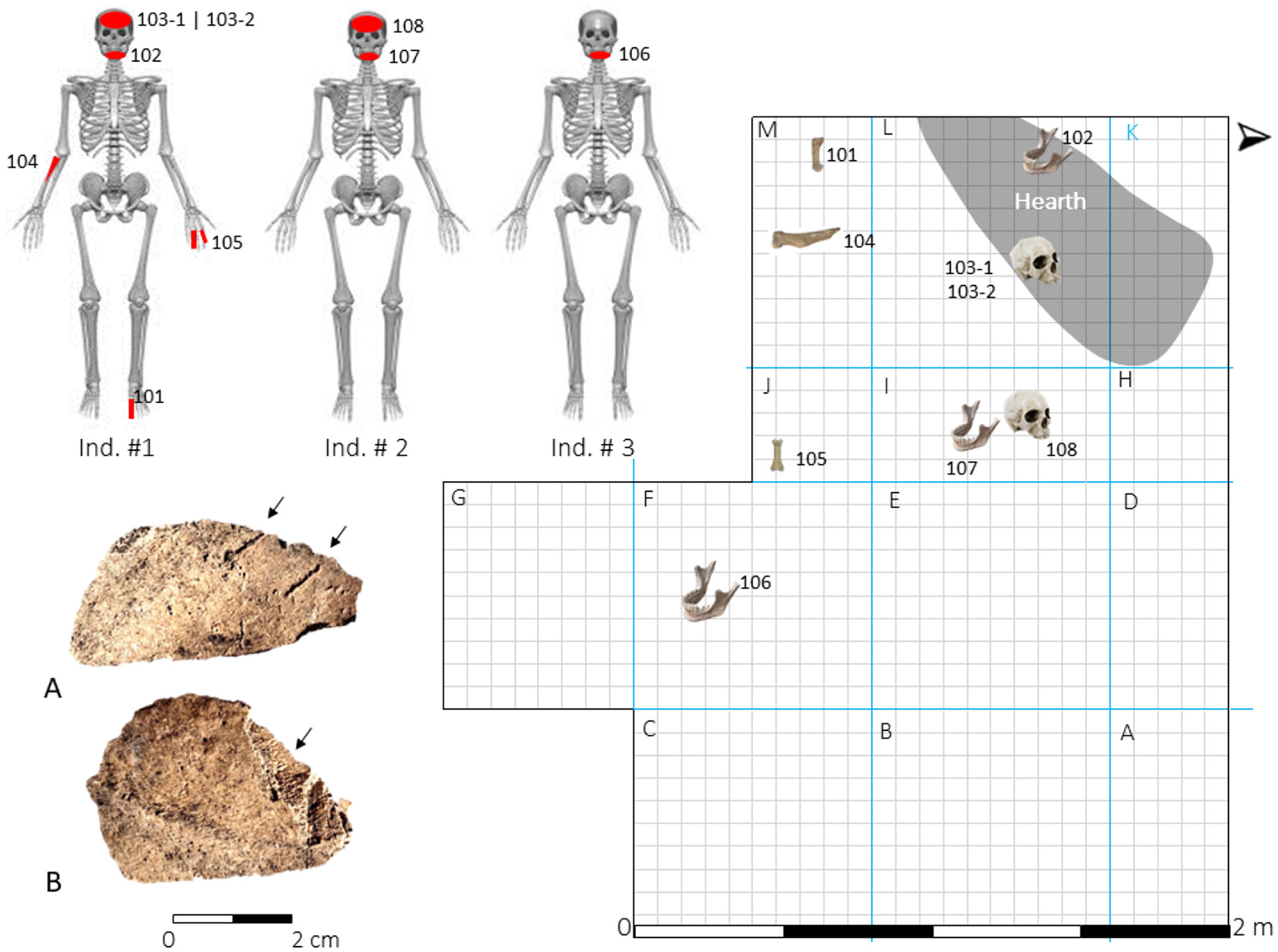
Sketch showing the location of human remains in Grid 2. Left: skeletal elements represented for each individual (see text for fragment attribution). Bottom left: (A) parallel marks of indeterminate origin (see text); (B) cranial fragment with possible fresh detachment of compact bone tissue.
Individual 1 is represented by cranial bones and several maxillary teeth (103-1 and 103-2 in Figure 10). The mandible and mandibular teeth (102) in the same figure are tentatively assigned to this individual, although further study is needed to confirm this. The mandible shows notable weathering—unusual compared to other human and faunal remains—suggesting prolonged surface exposure. One cranial fragment displays two short, deep parallel grooves, likely caused by a blunt object with a slightly convex edge. The grooves' flat bottoms and width suggest the object was not as sharp as a lithic flake (Fragment A, Figure 10). Both grooves and adjacent areas show chemical dissolution, probably from plant root activity, affecting their edges while retaining their originally straight design. Another cranial fragment exhibits compact bone delamination (Fragment B, Figure 10), consistent with detachment from fresh bone despite no visible percussion point. Further analyses are underway to determine the origin of these modifications.
Additionally, two hand phalanges (105), a metatarsal (101), and a proximal radius fragment (104) were recovered. These are included under Individual 1 in Figure 10 for illustrative purposes only, as their attribution remains uncertain. In the same figure, a mandibular ramus fragment (107) and two cranial fragments (108) are assigned to another adult, Individual 2; while fragment 107 clearly belongs to a different adult than Individual 1, the cranial fragments are tentatively attributed to Individual 2, which bear traces of charcoal adhering to their surfaces. Finally, Individual 3 is a subadult represented by a hemimandible fragment including teeth (106).
The previously identified human remains do not appear to originate from urn burials or other grave structures. Moreover, the configuration of the recovered skeletal elements is inconsistent with either disturbed primary or secondary burials, which typically display greater anatomical integrity, with bones that are either unbroken or exhibiting dry fractures (e.g., Carbonera et al., 2024; Lothrop, 1932; Loponte and Acosta, 2003–2005; Mazza et al., 2016). Notably, the concentration in Grid 2, consisting of multiple individuals with low skeletal completeness, mirrors patterns observed in the associated faunal assemblage, with which the human remains are mixed and radially arranged around the combustion feature.
Within this context, the presence of what may be processing marks on fragments of the cranium from Individual 1 is also noteworthy. Altogether, this evidence suggests that the human remains may have been part of consumption-related events. In previous excavations, scattered human remains mixed with animal bones were likewise recovered, again with no evidence of disturbed burials. One of these bone elements, a phalanx, shows clear signs of direct exposure to fire (Capparelli, 2019). A similar pattern—highly fragmented human bones mixed with faunal remains in combustion domestic areas—has been documented at Guaraní sites in southern Brazil (Rogge, 1996; Mentz Ribeiro, 2008; Spricigo and Carbonera, 2023). These increasingly recurrent findings at Guaraní sites call for detailed analytical studies to advance their proper interpretation, which will be addressed in future research.
6.3 Faunal assemblage
The faunal collection obtained during the 2023 field season includes 307 remains identified to some taxonomic level (Table 2), with ~90% recovered between the first and third extraction levels. Previous excavations by Capparelli (2014) identified 363 bones assigned to taxonomic categories, which are also included in Table 2 to provide a broader understanding of the assemblage. Since Capparelli's excavation areas are considerably distant from the 2023 excavations (Figure 6), the Minimum Number of Individuals -MNI, calculated following Klein and Cruz-Uribe (1984)—was estimated independently for each area; therefore, some degree of MNI overestimation cannot be completely ruled out.
Table 2
| Taxa | NISP (1) | NISP (2) | Total NISP | Total NISP % | Total MNI | Total MNI % | |
|---|---|---|---|---|---|---|---|
| Mammalia > 10 kg | Mammalia indet. | 83 | 78 | 161 | 24.0 | ||
| Artyodactila | 1 | 1 | 0.1 | ||||
| Blastocerus dichotomus | 2 | 25 | 27 | 4.0 | 2 | 5 | |
| Ozotoceros bezoarticus | 7 | 4 | 11 | 1.6 | 2 | 5 | |
| Hydrochoerus hydrochaeris | 3 | 14 | 17 | 2.5 | 2 | 5 | |
| Mamm. < 10 kg | Myocastor coypus | 14 | 38 | 52 | 7.8 | 9 | 22 |
| Cavia aperea | 25 | 6 | 31 | 4.6 | 6 | 15 | |
| Holochilus sp. | 1 | 1 | 0.1 | 1 | 2 | ||
| Aves and Reptiles | Tupinambis cf. merianae | 1 | 3 | 4 | 0.6 | 2 | 5 |
| Odontophrynus sp. | 3 | 3 | 0.4 | 3 | 7 | ||
| Aves | 4 | 4 | 0.6 | 1 | 2 | ||
| Rhea americana | 1 | 1 | 0.1 | 1 | 2 | ||
| Fish | Fish | 47 | 148 | 195 | 29.1 | 0 | |
| Actinoterigii | 114 | 114 | 17.0 | 0 | |||
| Pseudplastystoma sp. | 4 | 1 | 5 | 0.7 | 2 | 5 | |
| Pimelodus albicans | 5 | 5 | 0.7 | 1 | 2 | ||
| Prochilodus lineatus | 8 | 8 | 1.2 | 2 | 5 | ||
| Salminus cf. maxillosus | 1 | 1 | 0.1 | 1 | 2 | ||
| Rhamdia cf. sapo | 1 | 1 | 0.1 | 1 | 2 | ||
| Pimelodus maculatus | 8 | 8 | 1.2 | 2 | 5 | ||
| Pterodoras granulosus | 18 | 20 | 3.0 | 3 | 7 | ||
| Total | 307 | 363 | 670 | 100 | 41 | 100 |
Faunal assemblage of Arenal Central.
NISP (1) corresponds to the results from the 2023 excavation season, while NISP (2) refers to the remains recovered by Capparelli (2019).
The 2023 assemblage is exceptionally well-preserved: ~90% of mammal bones from animals over 5 kg exhibit weathering stage 1 (Behrensmeyer, 1978), while the remainder shows stages 2–3, mostly recovered from the first extraction level in contact with Layer D1. Both assemblages reflect similar exploitation patterns focused on fish and mammals over 10 kg (Table 2). No species preference was observed, consistent with other Guaraní faunal assemblages (Acosta et al., 2019). Among mammals, Blastocerus dichotomus (marsh deer, ~150 kg) is the largest identified prey. Its axial and appendicular remains suggest that entire carcasses were transported, although they are represented by few bones, indicating low completeness in the excavated area (Figure 11). Other species include Hydrochoerus hydrochaeris (capybara, 30–40 kg) and Myocastor coypus (coypu, 5–6 kg). Capybara remains, mostly phalanges and metapodials, indicate low anatomical completeness, while coypu shows greater skeletal representation. These mammals could have been hunted on the island, on the Uruguayan riverbanks, or on deltaic islands near the advancing Paraná Delta front. Fish remains show complete skeletal representation, suggesting that whole fish were transported to the site.
Figure 11

Top: Pie chart showing the composition of the faunal assemblage based on total %NISP and %MNI values (see Table 2). Bottom: Anatomical representation of B. dichotomus(A), R. americana(B), and O. bezoarticus(C), based on total NISP from Table 2. Some large bones are fully colored for visual clarity, although only small fragments were recovered (see text).
The collection also includes forelimb and hindlimb bones of Ozotoceros bezoarticus (pampas deer, ~25 kg), likely hunted in the Uruguayan plains across the Canal del Infierno (< 4 km away). In the same well-drained environment, Rhea americana (greater rhea) was also available, represented in the assemblage by a proximal tibiotarsus fragment (Figure 11).
The results described above indicate a broad-spectrum strategy characteristic of typical Guaraní foraging behavior (Acosta et al., 2019). Indeed, the 2023 faunal collection yields a Simpson's diversity index (Ds) of 0.72 (based on NISP), comparable to that of Capparelli's collection (Ds = 0.74; NISP). Biodiversity calculated using MNI is 0.82, closely aligning with the NISP-derived values. However, the diversity at Arenal Central is slightly lower than that observed in most Guaraní assemblages from northern subtropical forest sites, likely due to the higher species richness characteristic of the Atlantic Forest compared to the upper Río de la Plata estuary. Still, Arenal Central's niche breadth exceeds that of Arroyo Fredes, where a narrower niche reflects a higher incidence of fish remains (Acosta and Mucciolo, 2009; Musali, 2010a) (Figure 12).
Figure 12

Values of the Simpson (1949) biodiversity index for Guaraní faunal assemblages with adequately published data. Arenal Central is based on the 2023 collection results presented in Table 2 of this study; Arroyo Fredes is based on data published by Acosta and Mucciolo (2009: Table 1). In addition, six other sites located in the Atlantic Forest, published by Acosta et al. (2019), were also included. For the calculation of the index, only the number of identified bone elements (NISP) and the number of individuals (MNI) identified at the species level were considered, with the exception of fish which were treated as single (macro) taxa. Birds were also grouped as a single macrotaxon.
Some smaller taxa, such as Cavia aperea (Brazilian guinea pig), may have entered the archaeological record naturally. However, there is no strong reason to exclude this 300-gram rodent as a food resource, given its widespread pre-Columbian exploitation in the region (Acosta et al., 2010; Loponte, 2008). Although the bones lack evidence of fresh fractures or burning, a notable concentration of highly disarticulated and poorly represented remains was recovered within the small excavated area, consistent with patterns observed in other exploited species.
6.4 Pottery
A total of 1,230 ceramic fragments larger than 1 cm2 were recovered from Grid 2, including 146 rims and 1,084 body and base sherds. Approximately 92% of the assemblage came from the first three extraction levels of Layer D2 (10–12 cm thick). The recovered collection is entirely Guaraní in its decorative, typological, and technological attributes. Most sherds have plain (~61%) or corrugated (~31%) surfaces (Figures 13A–B), with smaller proportions of painted (~7%; Figures 13C–D) and other treatments (~1%; Figures 13E–G), all of which are also typical of Guaraní pottery. Of the 86 painted sherds, nearly 20% are rims. These proportions of surface treatments fall within the expected range for residential Guaraní assemblages analyzed under similar classification criteria (Table 3), which are characterized by a predominance of plain and corrugated vessels intended for domestic use, most likely functioning as cooking and food service containers. In contrast, amateur collections or burial contexts tend to exhibit higher frequencies of painted pottery (e.g., Lothrop, 1932; Pérez and Alí, 2017: Table 1).
Figure 13

Pie chart showing the main surface treatment types in the Arenal Central ceramic assemblage and examples of surface treatments. (A) corrugated surface; (B) plain; (C) painted (polychrome); (D) painted (red monochrome); Other categories: (E) fingernail impressions; (F) coiled; (G) brushed.
Table 3
| Sites | Location | Excavated area | Sample (n) | Plain (%) | Corrugated (%) | Painted (%) | Others (%) | Reference |
|---|---|---|---|---|---|---|---|---|
| Corpus | Upper Paraná River | House floor | 4,504 | 27.4 | 57.9 | 12.8 | 1.9 | 1 |
| Panambi 3 | Upper Uruguay River | House floor | 3,850 | 46.8 | 32.3 | 17.3 | 3.5 | 2 |
| Punta Negra Este | Lower Uruguay River | House floor | 2,043 | 36.8 | 23.1 | 27.1 | 13.0 | 3 |
| Paraná Guazu 3 | Paraná Delta- Rio de la Plata estuary | Unknown | 4,370 | 36.1 | 18.1 | 40.4 | 5.4 | 4 |
| Arroyo Fredes | House floor | 2,786 | 49.5 | 21.5 | 23.0 | 6.0 | 5 | |
| Arenal Central (2019) | House floor | 2,248 | 43.0 | 34.0 | 13.0 | 10.0 | 6 | |
| Arenal Central (2023) | House floor | 1,230 | 60.6 | 31.1 | 7.0 | 1.3 | 7 |
Surface treatments of ceramic sherds recovered from Guaraní sites in the Upper Paraná–Uruguay basins and the Paraná Delta–Río de la Plata estuary.
References: 1 = Carbonera and Loponte (2025); 2 = Loponte et al. (2022); 3 = Gascue and Bortolotto (2016); 4 = Caggiano (1982); Pérez (2016); 5 = Pérez and Alí (2017); 6 = Capparelli (2019); 7 = This study. The collection from Paraná Guazú 3 lacks precise characterization of the excavated area. The finer categories presented for Punta Negra Este site in Gascue and Bortolotto (2016) have been grouped into the four aggregation typologies used in this study, as shown in the surface treatments in Figure 13.
Most of the painted fragments are monochromatic, either white or red, as shown in Figure 13D. The red pigment was applied after the vessels were fired, and appears faint, diluted, and unevenly distributed. In contrast, the white pigment was applied before firing, either as a diluted slip or barbotine. In most of the white fragments, the slip is poorly preserved and, in some cases, has almost completely crackled and eventually worn away.
Polychrome ceramics are exceptionally rare, with only 17 fragments (1.4%) in the entire collection. These sherds feature simple linear or geometric motifs in black or red over a white slip, and less frequently black on red. The designs are mostly faded, contrasting with the excellent preservation of plain and corrugated ceramics and other indicators of good material preservation (see Section 6.1). This deterioration may reflect pigment quality and solubilization processes in porous sediments facilitating salt infiltration (e.g., Secco et al., 2011). The decorative patterns resemble those of northern Guaraní ceramics but appear less refined, with broader strokes and reduced geometric precision (Figure 14; see also Torino and Bonomo, 2024). In contrast, the corrugated pottery aligns stylistically and technologically with materials from the upper Uruguay basin, such as Panambí (Sempé and Caggiano, 1995; Loponte et al., 2022), and sites in southern Brazil (Carbonera and Loponte, 2024; Carbonera et al., 2021).
Figure 14

Polychrome ceramic fragments from Arenal Central. Each illustrated fragment is accompanied by its corresponding DStretch-enhanced image. Scales are approximate.
Typological reconstruction of the ceramic assemblage was limited by fragmentation and the low number of sherds per vessel. Nonetheless, some larger fragments and a few refits allowed estimates of vessel shape and size. Wall thickness further aided reconstruction, supported by comparative data from complete Guaraní pots documented in the literature (La Salvia and Brochado, 1989; Schmitz, 1991; Brochado and Monticelli, 1994; Prous and Lima, 2008; Noelli et al., 2018; Carbonera and Loponte, 2024).
One reconstructed vessel is a shallow, flat plate with a slightly concave profile, corrugated exterior, and smooth interior (Figure 15A), measuring ~40 cm in diameter. Its curvature suggests a possible alignment with the form shown in Figure 15I, which is similar to the “ñaembé” (emic name) used for food serving described in early 17th-century Jesuit missions (La Salvia and Brochado, 1989), though its design also resembles the nhamopiú or ñamipiú (emic names), used as toasters for cassava tortillas and other semi-solid foods (La Salvia and Brochado, 1989; Brochado and Monticelli, 1994).
Figure 15

Main typological groups identified at Arenal Central based on the collection from the 2023 season. The thickened area corresponds to fragments that have been identified (see the text above). The scale is approximate.
Larger vessels include at least two examples featuring three upper rings, as illustrated in Figure 15B. Similar containers—some with two or four upper rings—are commonly referred to in the literature as “cambuchí” (Ambrosetti, 1895; La Salvia and Brochado, 1989; Prous, 2010). Cambuchí vessels are large, robust containers with thick walls easily identifiable. They also display painted side panels, which may be simple and large in size or composed of multiple rings (“stepped shoulders” in the sense of Prous, 2010: 125), serving as unmistakable identifying features. These fragments cannot be confused with those of smaller and more delicate vessels, such as the “cambuchí caguabá” or other similarly small containers, nor with the large cooking pots known as yapepó (e.g., Ambrosetti, 1895; La Salvia and Brochado, 1989: 131, 137–139).
One of these vessels is undecorated, while the other displays geometric red patterns painted over a white background across the three rings (upper, middle, and lower), a distinguishing feature of these pots. A fragment from the lower ring of the latter is illustrated in Figure 14C. The fragmentation of these vessels produces a large number of painted sherds from the upper half of the containers and plain sherds from the lower half. In ethnographic contexts, vessels of this type are commonly associated with the preparation and storage of fermented beverages and other liquids (Ambrosetti, 1895; La Salvia and Brochado, 1989; Brochado and Monticelli, 1994).
Medium-sized vessels include pots with slightly inverted rims, like the one shown in Figure 15E, although some also feature straight or even slightly closed rims (same figure). Since no fragments connect the rims to the bases, these vessels could have had an abrupt carination, defining a pot with a short profile, or a very gentle carination resulting in a well-developed base corresponding to a pot with a taller profile and deeper base. These options are illustrated in Figure 15E. Historically, these vessels were used for cooking food and are referred to as yapepó by ethnographic Guaraní communities, with numerous variations depending on the specific form (Ambrosetti, 1895; La Salvia and Brochado, 1989; Brochado and Monticelli, 1994). Similarly, the Asurini people along the Xingú River, also part of the Tupi-Guaraní linguistic family, use the term japepá for similar vessels (Silva, 2010). Most of these cooking pots exhibit corrugated walls and often contain abundant charcoal particles on their exteriors, indicating use over fire.
Another type of pot, with straight or slightly inverted profiles, corresponds to the vessel depicted in Figure 15G, along with smaller forms like the one shown in Figure 15F. These vessels bear ethnographic names such as ñaetá or caguabá, depending on subtle variations in shape and size (La Salvia and Brochado, 1989). Both terms refer to containers used for serving food and beverages. These vessels generally have thinner walls than the cooking pots described earlier and show no evidence of fire exposure, further supporting their use as food-serving containers. While most of them feature plain surfaces, some smaller variants exhibit corrugation.
Three other vessel types, also typically Guaraní, were identified and are illustrated in Figures 15D, H, J. The first type consists of thin-walled vessels with a waist in the middle or upper third of the body, which never show signs of fire exposure. This suggests that they were not used for cooking but rather for storing and serving liquids. A fragment of this type is illustrated in Figure 13E. Similar vessels, known as yawi by the Asurini, are used for transporting and storing liquids (Silva, 2010). Ethnographic Guaraní also used small vessels with a narrow waist in the middle or upper third of the body, known as cambuchí yaruquaí, for storing or drinking liquids (La Salvia and Brochado, 1989). The remaining two types are low-walled vessels with slightly convex bases. Their walls are smooth and often painted up to the carina on the exterior. The paint typically consists of a white slip as the base, decorated with red or black geometric patterns or a simple red line parallel to the rim. Some also feature additional external geometric motifs, as seen in fragments 13C and 14B. A few fragments of vessels of this type display red paint as the base color, as observed in fragment 13D. The interiors of these vessels are usually painted monochrome red, occasionally incorporating geometric designs. At Arenal Central, these interior motifs are simple, such as those in Figure 14A, where the black lines appear to have been applied by finger-painting. The open, low-walled design suggests that these vessels were primarily used for serving food and beverages. Ethnographic parallels include cambuchí caguabá vessels, traditionally used for consuming fermented drinks (La Salvia and Brochado, 1989).
These are ethnographic functional categories and should be regarded as such. Nonetheless, the association between morphology and function shows remarkable temporal persistence, remaining consistent from the 17th century to the present across various ethnographic groups belonging to the Tupi-Guaraní language family (Ambrosetti, 1895; Brochado and Monticelli, 1994; La Salvia and Brochado, 1989; Noelli et al., 2018; Prous, 2010; Silva, 2010).
Within the ceramic assemblage, other vessel fragments have been identified that appear to be subtle variations of those previously described, as well as others with different morphologies. The incomplete nature of these fragments prevents a confident reconstruction of their profiles. Therefore, the typological reconstruction presented should be considered a minimum estimate of the typological diversity (Figure 15). Following a common convention in archaeological publications worldwide (e.g., Chirikure et al., 2013; Navarro et al., 2022; Stronach et al., 2019, among hundreds of published studies), certain sections of the profiles have been thickened to indicate the fragments from the 2023 collection that enable the reconstruction of the original vessel shapes.
6.5 Bone artifacts
Five bone artifacts were recovered during the 2023 excavation, four of which are illustrated in Figure 16. Among them is a projectile point made from the compact tissue of a large mammal's long bone (Figure 16A). It is not a Guaraní point; rather, it displays technological and stylistic features typical of bone points from hunter-gatherer sites on the right bank of the Paraná River and in the Paraná Delta (Loponte, 2008; Buc, 2012), including an elongated, thin blade, sharp barbs likely straightened by fractures, a short quadrangular stem, and a central groove possibly enhancing penetration. Two additional artifacts, likely projectile tips, were also found: one is a small fragment heavily fire-damaged; the other is made from the diaphysis of a medium-sized mammal, such as a coypu, similar to points occasionally found in Guaraní contexts (Figure 16B).
Figure 16

Bone artifacts from Arenal Central. (A) Reconstructed stemmed projectile point with (broken) barbs. (B) Hollowed point. (C) Polished bone splinter. (D) Fishhook (Season 2023). (E) Fishhook (Capparelli, 2019). (F) Fragment of a diaphysis, cut at both ends (Capparelli, 2019). The scale is approximate.
The fourth artifact (Figure 16C) is a polished, wedge-shaped compact bone fragment of unknown function. The fifth is a small fishhook (Figure 16D), similar to one from a prior excavation (Figure 16E; Capparelli, 2019). While still rare, such artifacts are increasingly reported in Guaraní contexts, including examples from Leandro Meier (Upper Uruguay River, unpublished) and Aldeia Ribanceira (Atlantic coast; Demathé, 2023). Capparelli (2014, 2019) also recovered a cut and polished diaphysis fragment (Figure 16F), possibly an inhalator, resembling ethnographic examples (e.g., Ostapkowicz, 2020).
6.6 Lithic artifacts
The lithic assemblage from the 2023 season includes 24 artifacts, among them four ax heads. Three appear fractured from use or manufacture, while the largest was likely still in production (Figure 17). All seem to be made from local Martín García Complex rocks, though petrographic analysis is needed to confirm lithologies. A second group comprises five river pebbles of microcrystalline or cryptocrystalline rocks; three show bipolar flake extraction (Figure 18B), one has a single percussion mark, and one remains unmodified. Another group includes 11 small flakes ( ≤ 6 cm) with natural edges, likely detached from these pebbles (Figure 18D). A silicified sandstone core was also recovered, showing multidirectional flake extraction by direct percussion (Figure 18A). Additionally, three local igneous-metamorphic fragments show polishing; one bears ochre traces on its polished surface, while the others may have served as a mortar. Four small pale red ochre pieces ( ≤ 3 cm) were also recovered.
Figure 17

(A) Unfinished ax head. (B, C) fragments of broken ax heads recovered from Grid 2. The scales are approximate.
Figure 18

(A) Silicified sandstone core. (B) Core of microcrystalline rock (fluvial pebble). (C, D) Flakes from microcrystalline rocks. The scales are approximate.
The nearest areas to Arenal Central for sourcing the fluvial pebbles of cryptocrystalline and microcrystalline rocks, basalts, and silicified limestones recovered at the site are the terraces and sandbars along the lower Uruguay River (Gentili et al., 1974; Gentili and Rimoldi, 1979; Loponte et al., 2011b; Silva-Busso and Amato, 2017). Silicified sandstones also occur in the surroundings of the lower Uruguay River (Salto Chico Formation; Gentili and Rimoldi, 1979; Franco, 2014). Although similar to the Ituzaingó Formation sandstones outcropping along the Paraná River and inland Entre Ríos (Silva-Busso and Amato, 2017), all evidence indicates the lower Uruguay River as the primary source area for these materials. The only well-documented Guaraní site in that area, featuring a reasonably well-preserved collection and a detailed publication, is Punta Negra Este, where the same lithic resources as those at Arenal Central were also used (Gascue and Bortolotto, 2016). The acquisition of these rocks from Arenal Central likely involved direct procurement, exchange, or both mechanisms, particularly considering the distribution of Guaraní sites in the estuary extending toward the lower Uruguay River (see below).
7 Discussion
7.1 Site structure and function
Arenal Central represents a Guaraní occupation on sedimentary Unit D, forming a thin archaeological layer that reflects domestic activities such as the preparation, consumption, and storage of food and beverages, along with the production, use, and disposal—intentional or not—of lithic and bone artifacts. This pattern aligns with a “house floor” record (LaMotta and Schiffer, 1999), similar to numerous Guaraní sites excavated in South Brazil and Argentina.
This domestic area also includes a combustion feature that appears to have structured part of the assemblage in Grid 2, likely active for an extended period with periodic maintenance. The ceramic assemblage consists of numerous vessels, each represented by only a few small fragments (see Section 6.4), suggesting repeated cycles of use, breakage, cleaning, and replacement. A similar process—preparation, consumption, disposal, and cleaning—likely explains the faunal assemblage, which is dominated by small bones. The human remains found in Grid 2 may also represent food-related disposal, based on their spatial arrangement, completeness, and fragmentation. The small crystalline rock cores are consistent with those commonly found in domestic contexts, where flakes were extracted as needed for household tasks. The identification of an unfinished ax head suggests that tool production, or at least part of it, took place within the domestic sphere.
Previous studies (Capparelli, 2014, 2019; see Table 1) indicate that Arenal Central covers a large area, consistent with a typical Guaraní residential base (e.g., Métraux, 1948; Schneider et al., 2024b). The archaeological record, discontinuously distributed and restricted to zones with charcoal-enriched sediments, reflects the characteristic Guaraní village layout of residential units organized around a central plaza, which accounts for this discontinuous pattern. Consequently, samples like the one obtained here are relatively small in scale compared to the overall size of Guaraní villages. Nevertheless, it is worth noting that previous excavations produced similar results (Capparelli, 2019).
7.2 Chronology
While the Spanish crown discovered America in 1492 CE, the Río de la Plata entered Europe's known geography in 1516 CE, when a Spanish fleet led by Juan Díaz de Solís first navigated the estuary (Madero, 1939)2. The earliest radiocarbon date from Arenal Central (Beta 662865; Table 1) falls between 1419 and 1499 CE (93%), leaving only a minimal probability (2.4%) of overlapping with the historical period (Figure 19). The other radiocarbon dates extend from the pre-European era to around 1600 CE, well into the historical period. This broad chronological range results from a plateau and minor reversal in the SHCal-20 calibration curve (~1460–1640 CE; Figure 19), preventing narrower dating. This issue parallels the “Ib perturbation” in the northern hemisphere (~1450–1630 CE; Taylor et al., 1996; Reimer et al., 2020), limiting high-resolution dating during this time range. Consequently, the calibrated ranges place Arenal Central's occupation not only during European exploration but also during the earliest Spanish settlements. Nonetheless, some historical events illuminate the likely timing of the site's depopulation, providing a framework for discussing its abandonment in greater detail.
Figure 19

Distribution of the calibrated date ranges from Table 1. Most dates from Arenal Central – El Arbolito are affected by a plateau and slight reversal in the SHCal-20 curve, except for Beta 662865 (red), which aligns with a well-sloped section, placing 93% of its range in precolonial times. The green dates (Beta 663813, Beta 663814, LP-2543, GrN 5146) also have lower bounds in precolonial times (~1450 CE), while the gray dates (Beta 662866, Beta 663812) show lower bounds near the historical period (1483 CE, 1497 CE; see Table 1).
During the first European expedition to the Río de la Plata in 1516 CE, a crew member of this fleet, Martín García, reportedly died of natural causes and was buried on the island, according to Fernández de Oviedo y Valdés [1526–1557] (1945). If accurate, this account suggests that the island was already uninhabited at the time. Indeed, there is no reference to the existence of a local population. Subsequent events further support the absence of a local population. After this stopover, Solís attempted to “capture a man to take to Castilla” (Herrera y Tordesillas A. de [1601-1615], 1944–1945), further implying that the small island had no inhabitants. While it is possible that Indigenous groups employed a strategy of “avoiding contact” with Europeans, it seems difficult to accept that the Spanish would not have noticed a village the size of a Guaraní settlement on an island as small as Martín García. This is hard to consider even for smaller settlements, especially when cultivated fields are also taken into account. For this reason, the complete absence of any mention of an indigenous presence on the island suggests that it was likely uninhabited at the time.
To achieve their objective of capturing a man, Solís and his crew immediately landed on the Uruguayan coast, “near Martín García Island” (Herrera y Tordesillas A. de [1601-1615], 1944–1945), possibly at Martín Chico or a nearby northern area. Here, the Spaniards observed indigenous people signaling to them from the beach. According to accounts from the remaining crew members aboard the anchored ships, Solís and several of his men were killed upon landing, then roasted and eaten, while the helpless crew watched from a distance, unable to intervene. While interpretations of this event in local historiography vary, the plausibility of the attack as described is supported by the consistency of the crew member testimonies, particularly if Guaraní groups were responsible for the deaths (cf. Herrera y Tordesillas A. de [1601-1615], 1944–1945; see also Bracco, 2004).
Regardless of the precise sequence of events described above, other evidence suggests that the island remained uninhabited in the years following Solís's expedition. In 1528 CE, Luis Ramírez, a member of Sebastián Gaboto's expedition to the Río de la Plata, visited an “island in the middle of the river.” Accompanied by indigenous guides, Ramírez stayed on the island for several days and described it as uninhabited and lacking food resources (Ramírez, 1528, in Madero, 1939). While Madero (1939) and Outes (1917) argue that this island corresponds to Martín García, some doubts remain regarding this identification, especially considering that the Río de la Plata estuary had a different configuration than it does today. Nevertheless, Ramírez's account is significant in broader terms, as it describes the area without mentioning the existence of nearby indigenous villages.
In 1531 CE, Pero Lopes de Souza [1530-1532] (1952) explored the island, which he named “Santa Anna,” without finding any inhabitants. A few years later, Buenos Aires was founded across from Martín García in 1536 CE but was abandoned in 1541 CE when Domingo Martínez de Irala depopulated the town. In a document addressed to future settlers, Martínez de Irala ([1541] in Zeballos, 1898) described the island (“Martín García” in the original text) as a suitable location for raising pigs. The letter's subject, the absence of any mention of local population on the island, and its proposed use for pig farming suggest that the island was uninhabited, consistent with previous accounts. Several years later, in 1573 CE, the army led by Juan Ortíz de Zárate was defeated by Indigenous groups in the so-called “Battle of San Gabriel.” The survivors sought refuge on the island (“Martín García”) for several days, which was again described as uninhabited (Rela, 2003). Finally, no European materials or exotic fauna were found during excavations at Arenal Central (Capparelli, 2014, 2019; this study). Based on these historical references and the absence of European materials, it is likely that the Guaraní population abandoned the island shortly before the onset of the historical period, possibly around 1516 CE, leaving no opportunity for exchange processes. However, minor or intermittent reoccupations cannot be entirely ruled out until ~1600 CE, when the Guaraní archaeological signal disappears as an independent unit throughout the entire area (Section 7.5).
7.3 Geographic location of Arenal Central during the Guaraní occupation
Estimates based on historical cartography from 1750 CE to the present suggest that the Paraná Delta's advancing front prograded at an average rate of 30 to 100 meters per year, depending on the sector and time period (Pittau et al., 2005; Medina and Codignotto, 2013). This implies that most Guaraní sites in the present Delta were established on sandy islands of the Río de la Plata estuary, several kilometers from the advancing front. The key question is whether it is possible to estimate their original distance from the Delta front.
Using the most conservative progradation rates reported by Pittau et al. (2005) and Medina and Codignotto (2013), it is possible to estimate the approximate position of the Delta's advancing front in 1500 CE (Figure 20), assuming an isometric advance similar to post-1750 CE rates and applying them to the detailed maps of Bellin (1759 CE) and Juan de la Cruz Cano y Olmedilla (1775 CE). This overlapping evidence suggests that Martín García Island was at least 25–35 km from the Delta front in 1500 CE. However, it is possible that several sedimentary islands had already formed between the settlement and the advancing front. Historical sources, such as Levinus Hulsius's map (c. 1599), support the presence of numerous islands in the Río de la Plata estuary, indicating that progradation during the 16th and 17th centuries involved the emergence of many small islands that gradually coalesced into a more defined Delta front, as shown in later maps. The insular nature of the known Guaraní sites in the area—each of them likely occupied prior to 1500 CE—closely aligns with the terminology used by early chronicles and Spanish colonial authorities to describe the Guaraní living near Buenos Aires, referred to as “Guaraníes de las islas” (“Guaraní of the islands”) (Fernández, 1582).
Figure 20

Left map: Location of the successive advancing fronts of the Paraná Delta up to 1750 CE, based on Medina and Codignotto (2013). The positions of earlier fronts (pre-1750 CE) are estimated here using isometric linear extrapolation from the most conservative progradation rates. Right map: Approximate location of the Paraná Delta's advancing front around 1500 CE, along with the distribution of currently known Guaraní sites. 1: Arroyo Malo – La Glorieta. 2: Arroyo Fredes. 3: Arroyo Largo. 4: Arenal Central. 5: Paraná Guazú 3 (approximate location). Smaller red dots represent isolated Guaraní burial urns and disturbed or destroyed Guaraní archaeological sites (see text).
7.4 Local production, catchment area and trade systems
Given the likely rapid depletion of exploitable faunal resources on the island—a common effect in small-island colonization (Plekhov et al., 2021)—and the lack of other critical resources, the human groups settled at Arenal Central appear to have acquired resources from at least four successive provisioning zones. The first and most immediate corresponds to the island itself, whose main resource for a horticultural society would have been its cultivated soils. The records of maize, squash, and beans (Section 4) could have been easily cultivated locally. The island's rock outcrops were also exploited. A second provisioning zone corresponds to fish resources obtained from the aquatic patch immediately surrounding the island. A third provisioning zone includes the mainland sector of the Uruguayan coast and the nearby sedimentary islands, which may have been incorporated within daily foraging range; here, the presence of cultivated plots cannot be ruled out (Figure 21). Finally, a fourth zone provided raw materials from the lower Uruguay River and, potentially, subsistence resources acquired from more distant parts of the Delta or the Argentine coast, accessed through logistical forays beyond the daily catchment radius and through exchange. Within this mechanism, chroniclers indicate that the local Guaraní population possessed metal artifacts acquired through their intra-ethnic network extending to the Andean region (Rodríguez, 1528 in Madero, 1939; Combès, 2008, 2015). However, metallic objects are extremely rare at Guaraní sites in the Delta. At Arroyo Fredes, two pure copper artifacts were recovered that may have an Andean origin, along with a third piece, an alloy likely of European origin (Buc et al., 2014). At Arenal Central, no metal artifacts have been recovered that can be definitively associated with the site's occupation.
Figure 21

Left: location of Martín García island (as # 4). Right: Martín Chico area on the Uruguayan coast in relation to Martín García Island and distances to Paraná Delta and the Pampas plain at the time of the Guaraní occupation.
To conclude this section, it is worth highlighting that the bone point described in Section 6.5 (Figure 16A) is not of Guaraní origin but instead exhibits traits typical of hunter-gatherers from the Paraná Delta and adjacent continental areas (Loponte, 2008; Buc, 2012). Its presence at Arenal Central is unlikely to result from exchange, as no artifacts associated with these populations have been found at the site. A plausible explanation is that it reflects episodes of interpersonal violence in the deltaic or nearby continental regions of the Argentinean coast.
7.5 Guaraní occupations in the Paraná Delta and the Río de la Plata estuary
A recent reanalysis of the complete set of Guaraní radiocarbon dates from southeastern South America suggests that the colonization of the Paraná Delta occurred during Phase III of their expansion, which began around 1300 CE and extended until ~1600 CE (Loponte et al., 2025), marking the peak of their geographic dispersal. In regions already occupied, there was a marked increase in the number of archaeological sites from around 1300 CE, indicating significant demographic growth. In contrast, in newly colonized areas during this period, such as the Paraná Delta, the Guaraní initially appear as a faint archaeological signal. This is precisely the case observed in the region, where the Guaraní record is detected around 1300 CE at a single site, followed by a notable increase in site frequency around 1450–1490 CE (Figure 22). Even when applying a Bayesian averaging model to the radiocarbon dates from the Arenal Central and Arroyo Fredes sites—designed to mitigate oversampling biases—this pronounced upward trend remains clearly visible (Figure 22). These findings suggest an initial pre-Columbian colonization by a small founder population with low demographic density, followed by a significant population increase shortly before the historical period. This demographic surge may reflect the arrival of new groups, internal growth, or both. Whichever the origin of this pulse may have been, this pattern aligns with pulsed migration and frontier expansion models (e.g., Lightfoot and Martinez, 1995), where small pioneering groups with low archaeological visibility are later followed by larger population movements that consolidate the colonization of new areas. This process may reflect strategic mobility to exploit colonization opportunities, as well as social mechanisms for territorial incorporation and alliance-building with established populations.
Figure 22

Left graph: Bayesian-weighted summed probability curve for radiocarbon dates from Guaraní sites in the Paraná Delta and Río de la Plata estuary. The curve was smoothed using a Gaussian filter (sigma = 10). Right: calibrated ranges calculated using OxCal 4.4.4 (Bronk Ramsey, 2021) and SHCal-20 (Hogg et al., 2020). The green ranges correspond to Arenal Central – El Arbolito, as referenced in Table 1 of this work. The dates for Arroyo Fredes were taken from Loponte et al. (2011a), except for AA-103896 (Bonomo et al., 2015), as well as the radiocarbon ages from Arroyo La Glorieta - Arroyo Malo sites. The Arroyo Fredes LTL 33020 radiocarbon determination was taken from Loponte et al. (2024).
Just as Guaraní colonization appears as a sudden event within the archaeological timescale, it also declines abruptly beginning in 1587 CE (Figure 22), roughly contemporaneous with the second foundation of Buenos Aires in 1580 CE. The city quickly became a colonial administrative center and overseas port, implementing the encomienda system from 1582 CE onward and integrating indigenous populations in the Buenos Aires region into the colonial structure. As part of this allocation of indigenous people to encomenderos3, 14 Guaraní caciques (chiefs) were included along with the population under their command (Fernández, 1582), suggesting that at least 14 Guaraní villages existed around Buenos Aires at that time. The proximity of these villages to the newly re-founded city, their predominantly insular situation, and the probable Spanish interference or destruction of the intra-ethnic networks of a population like the Guaraní—with stable villages dependent on large exploitation territories and their social connections—likely had a highly negative impact on their way of life, making them among the first indigenous communities in the area around Buenos Aires to become disarticulated.
The Guaraní colonization of the Paraná Delta and Río de la Plata estuary is unique, as they mainly established villages on islands, forming an approximately linear pattern parallel to the Delta's advancing front (Figure 20). This contrasts sharply with settlement patterns along the riverbanks in northern continental regions, highlighting the Guaraní's adaptability to an insular environment. However, this choice of suboptimal island locations was likely not voluntary but imposed by resistance from local groups against Guaraní expansion into the Delta and Paraná wetlands. These pre-existing non-Guaraní populations were complex hunter-gatherers with high demographic densities who actively defended their productive territories (Loponte et al., 2006; Acosta and Loponte, 2013). The Guaraní's arrival may have further reinforced this resistance, fostering alliances among local groups to oppose Guaraní colonization, as reflected in early European chronicles that document ongoing conflicts between both populations (e.g., Ramírez, 1528, in Madero, 1939; Fernández de Oviedo y Valdés [1526–1557], 1945.
Given these social constraints, occupying the Río de la Plata estuary—such as in the case of Arenal Central—may have represented a viable alternative for Guaraní expansion. However, Guaraní colonization of the estuary remained relatively limited. To date, the only site potentially representing a Guaraní settlement beyond Martín García is located at Arroyo Las Cañas, 70 km south of Arenal Central, on the right bank of the middle Río de la Plata estuary near La Plata (Maldonado Bruzzone, 1931) (Figure 23). This area also included a small riparian forest sector, similar to Martín Chico across from Martín García. Historical sources further suggest a faint Guaraní presence in the middle estuary (e.g., Fernández, 1582).
Figure 23

Locations of Guaraní sites in the Paraná Delta and the Río de la Plata estuary based on the most likely position of the Delta front around 1500 CE: 1 = Arroyo Malo - La Glorieta. 2 = Arroyo Fredes. 3 = Arroyo Largo. 4 = Paraná Guazú 3 (there is no precise information about the location of this site). 5 = Arenal Central (Martín García island). 6 = Las Cañas (uncertain assignment, see text). In yellow, examples of hunter-gatherer sites with Guaraní pottery: 7 = Los Molles. 8 = Divisadero 6. 9 = Canal 2 & La Loma. 10 = La Isolina. 11 = La Zeta (Aldazabal and Eugenio, 2013b).
This limited expansion may reflect less favorable environmental conditions for Guaraní niche construction. Unlike the lower Paraná Delta and broader wetlands, with extensive riparian and marginal forests spanning hundreds of square kilometers, the estuary offered only small, isolated forest patches along the riverbanks, with open grasslands beginning almost immediately inland. Another factor may have been risk minimization, as successive Spanish and Portuguese expeditions from 1516 CE and the establishment of settlements along the lower Paraná and Uruguay rivers—and in the estuary itself—may have discouraged or halted expansion.
If the Guaraní archaeological signal in the middle estuary is virtually absent, the farther one moves toward the outer estuary, only small quantities of Guaraní pottery are found at sites generated by hunter-gatherers (e.g., Aldazabal and Eugenio, 2013a,b; González and Frère, 2013) (Figure 23). These findings likely result from exchange, as small amounts of Guaraní pottery appear at numerous (perhaps hundreds) hunter-gatherer sites along the estuary and north along the Uruguay River (e.g., Gascue and Bortolotto, 2016; López Mazz and López Cabral, 2020; Torino and Bonomo, 2024). These are not Guaraní settlements but places where Guaraní ceramics, likely used as prestige goods, circulated through short- and medium-range exchange networks, unlike the permanent Guaraní settlements along the Paraná Delta front. Extensive research by González, Frère, Aldazábal, and Eugenio indicates that the absence of Guaraní sites in regions like the Salado Depression and the transitional zone to the Atlantic reflects a real pattern, not sampling bias. While a Guaraní village may eventually be found there, none has been identified so far.
7.6 Insularity, interaction, and colonization
One of the most debated issues in island archaeology concerns how the isolation of insular settlements has shaped material culture and the construction of local ecological niches, and whether surrounding aquatic environments acted as barriers or conduits fostering interaction with other societies—a question also central to broader debates on colonizing new environments (Anderson, 2006; Boomert and Bright, 2007; Broodbank, 2018; D'Arcy, 2006; Fitzpatrick and Anderson, 2008; Leppard et al., 2022; Napolitano et al., 2021; Moss, 2004; Rainbird, 2007). While most discussions have focused on oceanic islands, large estuarine islands like those in the Río de la Plata provide a valuable comparative context.
As this study shows, the development of the Guaraní niche involved both aquatic and terrestrial environments, conceived as a broad aquatic-terrestrial resource patch extending beyond a single island to include surrounding territories. This appropriation of an extended catchment also seems to have incorporated intra-ethnic social networks as an inherent resource. The clustering of villages within a narrow strip between the advancing Delta front and the upper estuary likely aimed to minimize negative Allee effects (Angulo et al., 2018), while maintaining distances sufficient to secure critical catchment zones for sustaining large population centers, exemplified by Guaraní villages like Arenal Central.
Given the limited carrying capacity of the small islands in the Paraná Delta and the Río de la Plata estuary, surrounding territories—both aquatic and terrestrial—became critical for subsistence. Canoe-borne fluvial mobility facilitated the exploitation of these extended aquatic-terrestrial areas and enabled the transport of large volumes of resources. However, this colonization strategy likely faced challenges, such as reduced inter-village contact, which may have led to diminished social interaction and likely contributed, at least in part, to the impoverishment observed in the ceramic stylistic record. Moreover, the availability and particular configuration of estuarine islands shaped not only resource access but also influenced the distances between Guaraní villages. Thus, the aquatic patch surrounding the island had a dual effect: on the one hand, it increased the landscape's resistance, while on the other, it simultaneously functioned as a space of connection.
8 Final remarks
Arenal Central was occupied at a later stage following the initial Guaraní colonization of the region, likely representing the southernmost settlement of this society along the Uruguay River axis. As such, it may reflect an attempt to expand further into the broader Río de la Plata estuary, given the social constraints on colonizing the Paraná Delta. The site functioned as a residential base for several decades, with its initial occupation beginning in the pre-Columbian period and possibly abandoned at the onset of historical times.
The recovered materials exhibit typical characteristics of Guaraní residential sites, including pottery, lithic and bone artifact types (with some previously noted exceptions), as well as characteristic resource exploitation strategies and faunal consumption patterns. Some variations in the archaeological record are also evident compared to other sites, such as a slight impoverishment or simplification in ceramic decorative styles. Due to the settlement's insular nature and the small size of the island, the population relied on a broad resource acquisition area based on fluvial mobility, including the exploitation of surrounding aquatic and terrestrial environments, as well as the open continental landscapes of the Uruguayan plains. This wide catchment area demonstrates a significant degree of adaptability to new environments, highlighting the importance of aquatic connections to the broader landscape and the availability of extended social networks.
Statements
Data availability statement
The original contributions presented in the study are included in the article/supplementary material, further inquiries can be directed to the corresponding author.
Author contributions
DL: Conceptualization, Data curation, Formal analysis, Funding acquisition, Investigation, Methodology, Project administration, Resources, Software, Supervision, Validation, Visualization, Writing – original draft, Writing – review & editing. MC: Conceptualization, Data curation, Formal analysis, Funding acquisition, Investigation, Methodology, Project administration, Resources, Software, Supervision, Validation, Visualization, Writing – original draft, Writing – review & editing. FS: Resources, Software, Supervision, Validation, Visualization, Writing – original draft, Writing – review & editing, Conceptualization, Data curation, Formal analysis, Funding acquisition, Investigation, Methodology, Project administration. NM: Conceptualization, Data curation, Formal analysis, Funding acquisition, Investigation, Methodology, Project administration, Resources, Software, Supervision, Validation, Visualization, Writing – review & editing. AB: Conceptualization, Data curation, Formal analysis, Funding acquisition, Investigation, Methodology, Project administration, Resources, Software, Supervision, Validation, Visualization, Writing – review & editing. MS: Data curation, Investigation, Writing – review & editing. AA: Data curation, Formal analysis, Investigation, Writing – review & editing. BM: Data curation, Formal analysis, Investigation, Methodology, Validation, Visualization, Writing – review & editing. SA: Writing – review & editing. IC: Formal analysis, Investigation, Methodology, Supervision, Writing – review & editing.
Funding
The author(s) declare that no financial support was received for the research and/or publication of this article.
Acknowledgments
Special thanks to Nazareno Asin, Gloria Domínguez, and all the members of the ranger team at the Martín García Natural Reserve for their essential support during our fieldwork. We also thanks to Andrés Gascue for the information provided on the contexts of the lower Uruguay River and for his suggestions on the manuscript, and to reviewers for their valuable comments and suggestions.
Conflict of interest
The authors declare that the research was conducted in the absence of any commercial or financial relationships that could be construed as a potential conflict of interest.
Generative AI statement
The author(s) declare that no Gen AI was used in the creation of this manuscript.
Publisher’s note
All claims expressed in this article are solely those of the authors and do not necessarily represent those of their affiliated organizations, or those of the publisher, the editors and the reviewers. Any product that may be evaluated in this article, or claim that may be made by its manufacturer, is not guaranteed or endorsed by the publisher.
Footnotes
1.^ This work includes more than 130 bibliographic references, ~110 of which correspond to studies conducted by around 150 researchers other than the authors. We have selected those that are properly published and most relevant to the topics of this study in terms of informational content, significance, and relevance. We trust that readers will understand that the large number of citations was necessary due to their direct relevance to this study.
2.^ There are references to earlier voyages, but there is no unanimous agreement among scholars (Arenas Deleón, 2023; Levillier, 1948; Madero, 1939).
3.^ The encomenderos were settlers granted the right to collect tribute and labor from indigenous people, whom they were also required to protect.
References
1
Acosta A. Carbonera A. Loponte D. (2019). Archaeological hunting patterns of Amazonian horticulturists: the Guarani example. Int. J. Osteoarchaeol.29, 999–1012. 10.1002/oa.2813
2
Acosta A. Loponte D. (2013). Complejidad social y estrategias de subsistencia en las poblaciones cazadoras-recolectoras del humedal del Paraná inferior. Cuadernos del Instituto Nacional de Antropología y Pensamiento Latinoamericano Series Especiales1, 60–74.
3
Acosta A. Loponte D. Mucciolo L. (2010). “Comparando estrategias de explotación faunística en el humedal del Paraná inferior: cazadores-recolectores vs. horticultores amazónicos,” in Zooarqueología a Principios del Siglo XXI: Aportes Teóricos, Metodológicos y Casos de Estudio eds. M. Gutiérrez, M. De Nigris, P. Fernández, M. Giardina, A. Gil, A. Izeta, G. Neme y H. Yacobaccio (Buenos Aires: Ediciones del Espinillo) pp. 177–188.
4
Acosta A. Mucciolo L. (2009). Zooarqueologia dos grupos horticultores Amazônicos no rio Paraná inferior: o caso do sítio Arroyo Fredes. Revista de Arqueologia22, 43–63.
5
Aldazabal V. Eugenio E. (2013a). “Sitios Los Molles, El Divisadero y La Loma,” in Cerámica Prehispánica de Tierras Bajas de Argentina. Vol. 1, eds. D. Loponte, and M. Pérez (Buenos Aires: Instituto Nacional de Antropología y Pensamiento Latinoamericano), pp. 7–11.
6
Aldazabal V. Eugenio E. (2013b). La cerámica unguicular y corrugada en la Pampa Deprimida. Contextos y discusión. Cuadernos del Instituto Nacional de Antropología y Pensamiento Latinoamericano Series Especiales 1 , 95–107.
7
Alí S. Pérez M. Carbonera M. Bozzano P. Domínguez S. (2017). Pigmentos de la alfarería Tupiguaraní: Análisis físico-químico Meb-Edax. Pesquisas Antropologia73, 31–52.
8
Almeida F. O. (2013). A Tradição Polícroma no Alto Rio Madeira. Dissertation. Universidade de São Paulo.
9
Ambrosetti J. B. (1895). Los cementerios prehistóricos del Alto Paraná (Misiones). Boletín del Instituto Geográfico Argentino16, 227–263.
10
Anderson A. (2006). Islands of exile: ideological motivation in maritime migration. J. Island Coast. Archaeol.1, 33–47. 10.1080/15564890600579858
11
Angulo E. Rasmussen G. S. A. Macdonald D. W. Courchamp F. (2018). Allee effects in social species. J. Animal Ecol.87, 47–57.
12
Arenas Deleón N. (2023). Juan Díaz de Solís y el descubrimiento del Río de la Plata. Diálogos y discusiones transnacionales para la elaboración de un relato histórico oficial en el Cono Sur (1860-1900). Co-Herencia20, 46–74. 10.17230/co-herencia.20.39.3
13
Arturi M. Juárez M. (1997). Composición de las comunidades arbóreas de la Isla Martín García en relación a un gradiente ambiental. Ecología Austral.7, 65–72.
14
Behrensmeyer A. K. (1978). Paleobiology. 4, 150–162.
15
Bellin N. (1759). Carte réduite de l'entrée de la rivière de la Plata contenant les costes de Buenos-Ayres et du Brésil depuis le Cap Sainte Marie jusqu'à la Cananea. Dépôt des Cartes et Plans de la Marine.
16
Benítez M. (2023). Evolución petrogenética del basamento ígneo-metamórfico de la Isla Martín García, Cratón del Río de la Plata, provincia de Buenos Aires. Dissertation. Universidad Nacional de La Plata.
17
Bertoncello A. Carbonera M. Lourdeau A. Pereira Santos M. C. Loponte M. (2024). Composição das pastas cerâmicas Guarani da área arqueológica da Foz do Chapecó, no alto rio Uruguai. Cadernos do LEPAARQ2142, 97–119. 10.15210/lepaarq.v21i42.27818
18
Bonomo M. Angrizani R. Apolinaire E. Noelli F. S. (2015). A model for the Guaraní expansion in the La Plata Basin and litoral zone of southern Brazil. Quat. Int.356, 54–73. 10.1016/j.quaint.2014.10.050
19
Bonomo M. Capdepont I. Matarrese A. (2009). Alcances en el estudio de colecciones. Los materiales arqueológicos del Delta del río Paraná depositados en el Museo de La Plata (Argentina). Arqueología suramericana/arqueologia sul-americana5, 68–101.
20
Boomert A. Bright A. (2007). Island archaeology: in search of a new horizon. Island Stud. J.2, 3–26. 10.24043/isj.197
21
Bracco D. (2004). Charrúas, guenoas y guaraníes. Interacción y destrucción: Indígenas en el Río de La Plata. Montevideo, Laborde y Risso.
22
Brochado J. P. (1973). Migraciones que difundieron la tradición alfarera Tupí-Guaraní. Relaciones de la Sociedad Argentina de Antropología7, 7–39.
23
Brochado J. P. (1984). An Ecological Model of the Spread of Pottery and Agriculture Into de Eastern South América. Dissertation. University of Illinois at Urbana Champaign.
24
Brochado J. P. (1989). A expansão dos Tupi e da cerâmica da tradição policrômica amazônica. Dédalo27, 65–82.
25
Brochado J. P. Monticelli G. (1994). Regras práticas na reconstrução gráfica de vasilhas de cerâmica Guarani a partir dos fragmentos. Estudos Ibero-Americanos XX:107–118.
26
Bronk Ramsey C. (2021). OxCal Program v4.4. [Software]. Available online at: https://c14.arch.ox.ac.uk/oxcal.html (accessed October 24, 2024).
27
Broodbank C. (2018). “Does island archaeology matter?” in Regional approaches to society and complexity: Studies in honor of John F. Cherry, eds. A. R. Knodell and T. P. Leppard (Sheffield: Equinox), pp. 188–206.
28
Buc N. (2012). Tecnología ósea de cazadores-recolectores del humedal del Paraná inferior. In Arqueología de la Cuenca del Plata. Series Monográficas. Instituto Nacional de Antropología y Pensamiento Latinoamericano. Buenos Aires.
29
Buc N. (2017). Tecnología ósea en la unidad arqueológica Guaraní. Pesquisas. Antropología73, 79–92.
30
Buc N. Cabanillas E. Davrieux M. (2014). Objetos metálicos entre grupos Guaraníes del Delta del Paraná. Holoceno tardío, Buenos Aires – Argentina. Revista do Museu de Arqueologia e Etnologia da USP 24 41–52
31
Burkart R. N Bárbaro R. Sánchez D. G. (1999). Ecoregiones de la Argentina. Administración de Parques Nacionales. Programa de Desarrollo Institucional Ambiental. Secretaría de Recursos Naturales y Desarrollo Sustentable. Buenos Aires.
32
Cabrera L. Zardini E. (1978). Manual de la Flora de los Alrededores de Buenos Aires. ACME. Buenos Aires.
33
Caggiano M. A. (1982). Análisis y Desarrollo Cultural Prehispánico en la Cuenca Inferior del Plata. Informe al CONICET. Buenos Aires.
34
Caldarelli S. (2008). Relatório parcial do projeto de arqueologia preventiva na expansão do sistema de transmissão Acre-Rondônia, subprojeto 1: Salvamento Arqueológico na Linha do Transmissão 230 kV Ji-Paraná - Pimenta Bueno - Vilhena –Rondônia.
35
Capparelli M. I. (2014). Arqueología de la Isla Martín García. Dissertation. Universidad Nacional de La Plata.
36
Capparelli M. I. (2019). 100 años de Arqueología en la Isla Martín García. Azara, Fundación de Historia Natural. Buenos Aires.
37
Capparelli M. I. Vázquez F. (2022). Registro arqueobotánico del sitio Arenal Central, Isla Martín García (Argentina). Uso y explotación de recursos silvestres y domesticados. Revista de Antropología del Museo de Entre Ríos6, 64–69. 10.5281/zenodo.6676566
38
Carbonera M. (2014). A ocupação pré-colonial do alto RioUruguai, SC: contatos culturais na Volta do Uvá. Dissertation. Universidade de São Paulo.
39
Carbonera M. (2024). Dentro e fora da urna: deposições funerárias da unidade arqueológica Guaraní a partir do sítio Uruguai 1, na Foz do Chapecó (RS). Bol Mus Para Emílio Goeldi 19:e20230056. 10.1590/2178-2547-BGOELDI-2023-0056
40
Carbonera M. Loponte D. (2020). Caracterización de las pastas cerámicas de las unidades arqueológicas Itararé-Taquara y Guaraní de los sitios de la Volta de Uvá, Alto río Uruguay. Revista de Arqueología33, 1–20. 10.24885/sab.v33i2.708
41
Carbonera M. Loponte D. (2024). Catálogo de cerâmica arqueológica Guarani do alto vale do rio Uruguai. Volume I. Chapecó.
42
Carbonera M. Loponte D. (2025). Avanços na arqueologia Guarani da província deMisiones: o sítio Corpus. Submitted for revision.
43
Carbonera M. Mohr M. Lino J. T. Loponte D. (2021). Aspectos tecnomorfológicos e estílisticos da cerâmica pintada Guarani do sítio Adão Sasanoviz (Alto Rio Uruguai). Cadernos do Lepaarq XVIII 35, 263–291.
44
Chirikure S. Pollard M. Manyanga M. Bandama F. (2013). A Bayesian chronology for Great Zimbabwe: re-threading the sequence of a vandalised monument. Antiquity87, 854–872. 10.1017/S0003598X00049516
45
Cigliano M. E. (1968). Investigaciones arqueológicas en el río Uruguay medio y la costa NE de la provincia de Buenos Aires. Pesquisas, Estudios Leopoldenses18, 5–9.
46
Combès I. (2008). Planchas, brazaletes y hachuelas: las rutas prehispánicas del metal andino desde el Guapay hasta el Pantanal. Revista Andina47, 53–82.
47
Combès I. (2015). De la una y otra banda del río Paraguay. Historia y Etnografía de los Itatines (Siglos XVI-XVIII). Instituto de Misionología, Cochabamba.
48
Dalla Salda L. H. (1981). El basamento de la Isla Martín García, Río de la Plata superior. Asociación Geológica Argentina 46 , 24–93.
49
D'Arcy P. (2006). The People of the Sea: Environment, Identity, and History in Oceania. Honolulu: University of Hawaii Press.
50
Demathé A. (2023). Programa de Gestão do Patrimônio Arqueológico na área de implantação do loteamento Mirante Da Baleia – Salvamento do Sítio Arqueológico Aldeia Ribanceira I, município de Imbituba-SC. Volume 1. Tubarão.
51
Fernández de Oviedo y Valdés G. (1945). Historia general y natural de las Indias. 7 Vols. Editorial Guarania. Asunción del Paraguay.
52
Fernández P. (1582). El repartimiento de indios de Juan de Garay. 28 de marzo de 1582. Archivo General de La Nación. Buenos Aires.
53
Fitzpatrick S. M. Anderson A. (2008). Islands of Isolation: Archaeology and the Power of Aquatic Perimeters. J. Isl. Coast. Archaeol.3, 4–16. 10.1080/15564890801983941
54
Franco M. J. (2014). Estípites de Arecaceae en la Formación Ituzaingó (Plioceno-Pleistoceno), Entre Ríos, Argentina. Acta Geológica Lilloana26, 14–29.
55
Gascue A. Bortolotto N. (2016). La ocupación guaraní en la margen oriental del bajo río Uruguay: Tecnología cerámica y lítica del sitio Punta Negra Este. Actas del XIX Congreso Nacional de Arqueología Argentina, pp. 487–495.
56
Gentili C. A. H. L Rosenman A. M. Lourenço (1974). Características geológicas generales del territorio brasileño en la faja adyacente en el curso medio del río Uruguay. Revista Asociación Geológica Argentina29, 223–230.
57
Gentili C. A. Rimoldi H. V. (1979). Mesopotamia. Segundo Simposio de Geología Regional Argentina. Córdoba: Academia Nacional de Ciencias1, 185–223.
58
González I. Frère M. M. (2013). “Sitios Barranca del Río Salado, El Bote, La Guillerma (I, II, IV, V), La Guillerma Ñandú, Laguna Vitel, San Ramón y Techo Colorado,” in Cerámica Prehispánica de Tierras Bajas de Argentina, Vol. 1, eds. D. Loponte, and M. Pérez (Buenos Aires: Instituto Nacional de Antropología y Pensamiento Latinoamericano), pp. 37–76.
59
Goulart M. (1987). A Pré-História da Volta doUvá-SC/RS: Barragem Itá. Final Report. Universidade Federal de Santa Catarina – Eletrosul S. A. Florianópolis.
60
Herrera y Tordesillas A. de [1601-1615]. Historia general de los hechos de los castellanos en las islas y tierra firme del mar océano. Asunción del Paraguay: Editorial Guarania. (1944–1945).
61
Hogg A. G. Heaton T. J. Hua Q. Palmer J. G. Turney C. S. M. Southon J. et al . (2020). SHCal20 Southern Hemisphere Calibration, 0–55,000 years cal. BP. Radiocarbon62, 759–778. 10.1017/RDC.2020.59
62
Klein R. G. Cruz-Uribe K. (1984): The Analysis of Animal Bones from Archaeological Sites, 1–273. The University of Chicago Press, Chicago.
63
La Salvia F. Brochado J. (1989). Cerâmica Guaraní. Porto Alegre: Posenato Arte and Cultura.
64
LaMotta V. M. Schiffer M. B. (1999). “Formation Processes of House Floor Assemblages,” in The Archaeology of Household Activities, ed. P. M. Alisson (London: Routledge), pp. 19–29.
65
Leppard T. P. Cochrane E. E. Gaffney D. et al . (2022). Global Patterns in Island Colonization during the Holocene. J World Prehist.35, 163–232. 10.1007/s10963-022-09168-w
66
Levillier R. (1948). América, la bien llamada (2 tomos). Buenos Aires: Editorial Guillermo Kraft Ltda.
67
Lightfoot K. Martinez A. (1995). Frontiers and boundaries in archaeological perspective. Annu. Rev. Anthropol.24, 471–419.
68
Lopes de Souza P. [1530-1532] (1952). Diario de Navegação. Companhia Editora Nacional: Río de Janeiro.
69
López Mazz J. M. López Cabral R. M. (2020). The presence of Guaraní groups in the current Uruguayan territory. J. Anthropol. Archaeol.59:101193.
70
Loponte D. (2008). Arqueología del Humedal del Paraná Inferior. In Loponte, D., Acosta. A., (Eds.) Arqueología de Cuenca del Plata. Series Monográficas. Instituto Nacional de Antropología y Pensamiento Latinoamericano. Buenos Aires.
71
Loponte D. Acosta A . (2003–2005). Nuevas perspectivas para la arqueología “Guaraní” en el humedal del Paraná inferior y Río de la Plata. Cuadernos del Instituto Nacional de Antropología y Pensamiento Latinoamericano 20, 179–197.
72
Loponte D. Acosta A. Capparelli M. I. Pérez M. (2011a). “La arqueología guaraní en el extremo meridional de la cuenca del Plata,” in Arqueología Tupiguaraní, eds. Loponte, D., Acosta, A. (Instituto Nacional de Antropología y Pensamiento Latinoamericano: Buenos Aires), pp. 111–154.
73
Loponte D. Acosta A. Gascue A. Carbonera M. Benazzi S. Bortolini E. et al . (2024). Radiocarbon dating and Bayesian modeling of pre-Columbian occupations in the Paraná Delta, Argentina. 4th International Conference on Radiocarbon in the Environment Conference. RE-IV Conference. Lecce.
74
Loponte D. Acosta A. Musali J. (2006). “Complexity among hunter-gatherers from the Pampean region, South America,” in Beyond Affluent Foragers, eds. Grier, C., Kim, J., Uchiyama, J. (Oxford: Oxbow Books), pp. 106–125.
75
Loponte D. Capparelli M. I. (2013). “Sitios Arroyo Fredes, Kirpach y Arenal Central,” in Cerámica Prehispánica de Tierras Bajas de Argentina. Volumen I. Instituto Nacional de Antropología y Pensamiento Latinoamericano, eds. Loponte. D., Pérez M. (Buenos Aires), pp. 1–6.
76
Loponte D. Carbonera M. Corriale M. Acosta A. (2016). Horticulturalists and oxygen ecozones in the tropical and subtropical forests of Southeast South America. Environ. Archaeol. 22, 247–267. 10.1080/14614103.2016.1211382
77
Loponte D. Carbonera M. Schneider M. Gascue A. Milheira R. G. Pereira Santos M. C. et al . (2025). The Guaraní expansion through the Lowlands of South America. J. Anthropol. Archaeol. Sci. 17, 1–40. 10.1007/s12520-024-02158-3
78
Loponte D. Sacur Silvestre R. Tchilinguirián P. (2011b). “Caracterización de afloramientos de calizas silicificadas de la provincia de Entre Ríos (Argentina) y su vinculación con los circuitos de abastecimiento prehispánico,” in Avances y perspectivas en la arqueología del Nordeste eds. Feuillet Terzaghi, M. R., Colasurdo, B., Sartori, J., Escudero, (Santa Fe), pp. 125–140.
79
Loponte D. Sempé C. Al,í S. Carbonera M. Silvestre R. Bertoncello A. et al . (2022). El sitio arqueológico Guaraní Panambí 3, provincia de Misiones, Argentina. Cadernos do Lepaarq XIX38, 7–39.
80
Lothrop S. (1932). Indians of the Paraná Delta River. Annals of the New York Academy of Sciences. XXXIII: 77–232.
81
Madero E. (1939). Historia del Puerto de Buenos Aires. Ediciones Buenos Aires. Buenos Aires.
82
Maldonado Bruzzone A. (1931). Breve reseña del material recogido en Punta Lara (Prov. de Buenos Aires). Notas Preliminares del Museo de La Plata Tomo I: 339–354.
83
Mazza B. Acosta A. Loponte D. (2016). Nuevos Datos para las Inhumaciones en Urnas de Sitios Arqueológicos Guaraníes del Extremo Meridional de la Cuenca del Plata. Revista Chilena de Antropología34, 81–96.
84
Medina R. Codignotto J. (2013). Evolución del delta del río Paraná y su posible vinculación con el calentamiento global. Revista Museo Argentino de Ciencias Naturales15, 191–200. 10.22179/REVMACN.15.181
85
Mentz Ribeiro P. A. (2008). “A tradicao ceramista Tupigurani no sul do Brasil,” in Os Ceramistas Tupiguarani eds. A. Prous and T. Lima Andrade (Sigma: Belo Horizonte), pp. 179–196.
86
Métraux A. (1948). “The Guarani,” in Handbook of South American Indians: The Tropical Forest Tribes. Volume 3, ed. J. H. Steward, (Washington: Smithsonian Institution Bureau of American Ethnology), pp. 69–94.
87
Milheira R. (2014). Arqueologia Guaraní na laguna dos Patos e Serra do Sudeste. Editora da UFPel, Pelotas.
88
Miller E. T. (2009). A Cultura Cerâmica do Tronco Tupí no alto Ji-Paraná, Rondônia, Brasil: Algumas Reflexões Teóricas, Hipotéticas e Conclusivas. Revista Brasileira de Linguística Antropológica1, 35–136.
89
Moss M. L. (2004). “Island societies are not always insular: Tlingit territories in the Alexander Archipelago and the adjacent Alaska mainland,” in Voyages of Discovery: The Archaeology of Islands, ed. S. M. Fitzpatrick (Westport, CT: Praeger), 165–183.
90
Müller L. M. de Souza S. H. F. M. (2011). “Enterramentos Guaraní: problematização e novos achados,” in Antes do Oeste de Santa Catarina: arqueologia dos povos indígenas , eds. M. Carbonera and P. I. Schmitz (Argos: Chapecó), pp. 167–218.
91
Musali J. (2010a). El rol de los peces en la dieta de los grupos horticultores de tradición Tupíguaraní: el caso de Arroyo Fredes (Partido de San Fernando, provincia de Buenos Aires, Argentina). Archaeofauna19, 37–58.
92
Musali J. (2010b). El rol de la pesca entre los grupos humanos de la baja Cuenca del Plata. Ictioarqueología de conjuntos prehispánicos del Holoceno tardío en el humedal del Río Paraná inferior. Dissertation. Universidad de Buenos Aires.
93
Napolitano F. DiNapoli J. Stone J. (2021). “Introduction: The Archaeology of Island Colonization,” in The Archaeology of Island Colonization: Global Approaches to Initial Human Settlement, eds. M. F. Napolitano, J. H. Stone, and R. J. DiNapoli (University Press of Florida), pp. 1–34.
94
Navarro P. Cintas C. Lucena M. et al . (2022). Reconstruction of Iberian ceramic potteries using generative adversarial networks. Sci Rep12:10644. 10.1038/s41598-022-14910-7
95
Noelli F. Brochado J. P. Correa A. (2018). A linguagem da cerâmica Guaraní: sobre a persistência das práticas e materialidade (parte 1). Revista Brasilera de Lingüística Antropológica10, 167–200. 10.26512/rbla.v10i2.20935
96
Noelli F. S. (1993). Sem tekoha não há tekó: em busca de um modelo etnoarqueológico da subsistência e da aldeia Guaraní aplicado a uma área de domínio do delta do Jacuí – RS. 1993. Dissertação PUC-RS, Porto Alegre.
97
Noelli F. S. (1999–2000). A ocupação humana na Região Sul do Brasil: arqueologia, debates e perspectivas (1872-2000). Revista USP 218–269.
98
Noelli F. S. Correa A. A. (2016). Arqueologia regional e a construção das paisagens Guarani na margem esquerda do rio Paraná, Estado do Paraná, Brasil. Rev. Cadernos Ceom29, 87–112. 10.22562/2016.45.04
99
Novasco R. De Bona Mello A. Cerezer J. Schwengber V. Mafioletti Júnior V. Vieira Torquato T. et al . (2021). Apontamentos sobre a ocupação Guaraní no litoral sul de Santa Catarina: o caso do sitio arqueológico baixo rio d'una 1. Pesquisas, Antropologia76, 129–142.
100
Ostapkowicz J. (2020). Conduits to the supernatural: Bifurcated snuff tubes in the pre-Columbian Caribbean. J. Carib. Archaeol.20, 45–67.
101
Outes F. (1917). Primer hallazgo arqueológico en la isla Martín García. Anales de la Sociedad Científica Argentina LXXXII:265–277.
102
Outes F. (1918). Nuevos rastros de la cultura Guaraní en la cuenca del Paraná inferior. Anales de la Sociedad Científica Argentina LXXXII:153–182.
103
Pazzi F. (2021). Tecnología lítica en contextos guaraníes. Resultados del análisis de las colecciones “Isla Martín García” y “La Correntina.” Arqueología27, 179–191.
104
Pérez M. (2016). La cerámica del sitio Paraná Guazú 3. Vinculaciones con otros conjuntos guaraníes de la cuenca del Paraná. Actas del XIX Congreso Nacional de Arqueología Argentina507–512.
105
Pérez M. Alí S. (2017). Comparando registros de alfarería Tupiguaraní en Argentina. Pesquisas. Antropología73, 121–144.
106
Pérez M. Capparelli M. I. Loponte D. Montenegro T. Russo N. (2009). Estudo petrográfico da tecnologia cerâmica Guarani no extremo sul de sua distribução: Rio Paraná inferior e estuário do Rio da Prata, Argentina. Revista de Arqueologia22, 65–82.
107
Pérez M. Silvestre R. Buc N. (2018). Tecnología de grupos guaraníes en las cuencas alta y baja de los ríos Paraná y Uruguay. Revista de Antropología del Museo de Entre Ríos4, 41–65.
108
Pittau M. Sarubbi A. Menéndez A. (2005). Análisis del avance del Frente y del incremento areal del Delta del Río Paraná. XX Congreso Nacional del Agua. Mendoza.
109
Plekhov D. Leppard T. P. Cherry J. F. (2021). Island Colonization and Environmental Sustainability in the Postglacial Mediterranean. Sustainability13:3383.
110
Prous A. (2010). “A pintura na cerámica Tupiguaraní,” in , Os Ceramistas Tupiguarani, elementos decorativos, vol II. eds. A. Prous and T. Lima (Superintendencia do IPHAN: Belo Horizonte), pp. 113–216.
111
Prous A. Lima T. (2008). Os Ceramistas Tupiguarani. Sigma, Belo Horizonte.
112
Rainbird P. (2007). The Archaeology of Islands. Cambridge: Cambridge University Press.
113
Ravizza G. B. (1982). Geología del Pleistoceno Holoceno de la isla Martín García. Río de la Plata Superior. Dissertation. Universidad Nacional de Buenos Aires.
114
Reimer P. J. Austin W. E. N. Bard E. Bayliss A. Blackwell P. G. Ramsey C. B. et al . (2020). The IntCal20 Northern Hemisphere radiocarbon age calibration curve (0–55 cal kBP). Radiocarbon62, 725–757. 10.1017/RDC.2020
115
Rela W. (2003). Colonia del Sacramento, 1678-1778. Intendencia Municipal de Colonia
116
Rogge J. H. (1996). Adaptação na Floresta Subtropical: a Tradição Tupiguarani no Médio Rio Jacuí e no Rio Pardo. Documentos 06. São Leopoldo: IAP/ UNISINOS.
117
Schmidl U. [1536–1554] (1948). Crónica del Viaje a las Regiones del Plata, Paraguay y Brasil. Editorial Peuser. Buenos Aires.
118
Schmitz P. I. (1991). “Migrantes da Amazônia: a tradição Tupi-Guaraní,” in Arqueologia pré-histórica do Rio Grande do Sul, ed. Kern, A. A. pp. 295–330. Mercado Aberto. Porto Alegre.
119
Schmitz P. I. (2008). A decoraçao plástica na cerámica da tradiçao Tupiguaraní. In Prous, A., Lima, T. (Eds.) Os Ceramistas Tupiguarani, elementos decorativos, vol II. Superintendencia do IPHAN, Belo Horizonte, pp. 7–26.
120
Schneider F. Corteletti R. Freitas E. M. de, Loponte, D. Machado N. T. G. (2024a). “Cultivo e consumo de plantas entre os Guaraní pré- coloniais do Sul do Brasil: uma contribuição a partir de vestígios carpológicos,” in 20 anos de Arqueobotânica no Brasil, eds. Scheel-Ybert (Uma disciplina em ascenso, Serie Livros Digital Museu Nacional, Rio de Janeiro), pp. 152–179.
121
Schneider F. Machado N. Carbonera M. Loponte D. Schneider P. et al . (2024b). Arqueologia Guarani no Vale do Taquari pós-enchente: os primeiros dados do sítio RS-T-138, Roca Sales, Rio Grande do Sul. V Jornadas de Actualización en Arqueología Guaraní. Taquara.
122
Secco M. Maritan L. Mazzoli C. Lampronti I. G. Zorzi F. Nodari L. et al . (2011). Alteration processes of pottery in lagoon-like environments. Archaeometry53, 809–829.
123
Sempé M. C. Caggiano M. A. (1995). Las culturas agroalfareras del Alto Uruguay (Misiones, Argentina). Revista do Museu de Arqueología e Etnología 5, 27–38.
124
Silva F. A. (2010). “A Aprendizagem da tecnología cerámica entre os Asurini do Xingu,”in Os Ceramistas Tupiguarani. Eixos Temáticos III, eds. A. Prous and T. Lima (pp. 7–26). Belo Horizonte.
125
Silva-Busso A. Amato S. (2017). Depósitos fluviales del plio-pleistoceno-holoceno de la Provincia de Entre Ríos y sus Implicancias Hidrogeológicas. Revista de la Asociación Geológica Argentina74, 338–356.
126
Silvestre B. R. Capparelli M. I. (2017). La tecnología lítica de grupos guaraníes prehispánicos en la Cuenca inferior del río Paraná. Pesquisas Antropologia73, 53–77.
127
Silvestre R. Buc N. (2015). Experimentação e Traceologia: Explorando a funcionalidade dos calibradores dos sítios arqueológicos de tradição Tupiguarani, Argentina. Teoria and Sociedade23, 125–151.
128
Simpson E. H. (1949). Measurement of diversity. Nature163:688.
129
Spricigo B. Carbonera M. (2023). Dados preliminares do estilo da cerâmica do sítio arqueológico Guarani U-381 Batista Recttor. Caderno de Resumos XII Encontro da Sab Sul e IV Jornadas de Atualização em Arqueologia Guarani Sul, p.34. Chapecó.
130
Stronach R. Stronach D. Farahani A. Parsons A. (2019). Mid-Parthian Pottery from Building V at Shahr-i Qumis. Iran57, 185–234. 10.1080/05786967.2019.1633242
131
Taylor R. E. Stuiver M. Reimer P. J. (1996). Development and extension of the calibration of the radiocarbon time scale: archaeological applications. Quat. Sci. Rev.15, 655–668.
132
Torino R. Bonomo M. (2024). Análisis estilístico y arqueométrico de la cerámica pintada guaraní del Delta del Paraná e isla Martín García (argentina). Relaciones 49, e103. 10.24215/18521479e103
133
Vignati M. (1936). Arqueología de la Isla Martin García. Physis12, 31–44.
134
Vignati M. (1941). Censo óseo de paquetes funerarios de origen Guaraní. Revista del Museo de La Plata (Nueva serie) II: 1-11.
135
Zeballos E. (1898). La relacion que dexo dominco minez de yrala en buenos ayres al tpo q. La despoblo. Boletín del Instituto Geográfico Argentino XIX: 261–271.
136
Zimpel N. C. (2009). Na direção das periferias extremas da Amazônia: arqueología na bacia do rio Ji-Paraná, Rondônia. Dissertation. Universidade de São Paulo.
137
Zimpel N. C. (2018). A Fase Bacabal e seus Correlatos Arqueológicos na Amazônia. Dissertation. Universidade de São Paulo.
Summary
Keywords
Guaraní archaeology, Guaraní expansion, La Plata Basin, Arenal Central site, Martín García Island
Citation
Loponte D, Carbonera M, Schneider F, Machado N, Bertoncello A, Szczygel MT, Acosta A, Mazza B, Alí S and Capparelli I (2025) At the Southern limit: the Arenal Central site and the Guaraní occupation of the Paraná Delta (Argentina). Front. Environ. Archaeol. 4:1535551. doi: 10.3389/fearc.2025.1535551
Received
27 November 2024
Accepted
14 May 2025
Published
18 June 2025
Volume
4 - 2025
Edited by
Claudia Speciale, Institut Català de Paleoecologia Humana i Evolució Social (IPHES), Spain
Reviewed by
Andrés Robledo, IPHES-CERCA, Spain
Jason Nesbitt, Tulane University, United States
Updates
Copyright
© 2025 Loponte, Carbonera, Schneider, Machado, Bertoncello, Szczygel, Acosta, Mazza, Alí and Capparelli.
This is an open-access article distributed under the terms of the Creative Commons Attribution License (CC BY). The use, distribution or reproduction in other forums is permitted, provided the original author(s) and the copyright owner(s) are credited and that the original publication in this journal is cited, in accordance with accepted academic practice. No use, distribution or reproduction is permitted which does not comply with these terms.
*Correspondence: Daniel Loponte dashtown@gmail.com
†ORCID: Daniel Loponte orcid.org/0000-0002-3826-5595
Disclaimer
All claims expressed in this article are solely those of the authors and do not necessarily represent those of their affiliated organizations, or those of the publisher, the editors and the reviewers. Any product that may be evaluated in this article or claim that may be made by its manufacturer is not guaranteed or endorsed by the publisher.