 Jesse Morin
 Morgan Ritchie2
- 1Institute for Oceans and Fisheries, University of British Columbia, Vancouver, BC, Canada
- 2Department of Archaeology, Simon Fraser University, Burnaby, BC, Canada
- 3ESRI Canada, Professional Services, North Vancouver, BC, Canada
In this paper we use Least Cost Analysis (LCA) and GIS to model site catchments for villages from two Coast Salish tribes—Tsleil-Waututh and Sts'ailes. Here, we use Tobler's Hiker Function to model travel by land and develop a cost raster for travel by water in canoes. This model is then used to describe the site catchments for a number of villages. Comparison of the LCA model with recorded resource use patterns and modern hiking and canoeing times suggest that the model accurately describes traditional landscape and seascape use. The shape and size site catchments emphasize the importance of canoe travel in structuring Coast Salish daily foraging radii (~13 km). The large size site catchments of individual villages indicates that even one centrally-placed village could have exploited much of the tribal territory on a near-daily basis. Further, we find correspondence between our LCA modeled use areas and observed use areas, and the extent of each tribes' respective territory, indicating that the model is accurate in predicting past use areas, and that such use areas closely reflect the metes and bounds of a tribes' territory.
Introduction
It was only a few generations ago that Indigenous peoples on the Northwest Coast of North America traveled on rivers, lakes, and saltwater by dugout canoe and throughout their homelands on overland foot trails. These modes of travel influenced settlement, land use, and territoriality because they patterned the direction, distance, and speed that people could move to obtain food, transport materials, and interact with others. In this study we examine the relationship between travel time and territoriality, with reference to two case studies from the Salish Sea region of the Northwest Coast.
The Salish Sea is one of the world's largest, most biologically rich, and culturally diverse inland seas (Figure 1). It is connected to the North Pacific Ocean by the Strait of Juan de Fuca and Johnstone Strait and to distant inland areas by major rivers, including the Fraser which flows from the Rocky Mountain, more than 1,600 km distant. The coastline length of the Salish Sea is over 7,450 km, with more than 400 coastal islands, and a sinuous shoreline punctuated with estuaries and bays. Massive freshwater lakes drain into tributary rivers which in turn flow into the lower Fraser, effectively, connecting the entire Salish Sea watershed basin (Carlson, 2010). Canoe was, by far, the most important mode of travel and transporting materials across short and long distances in the Salish Sea. People made at least five different types of canoes specialized for different waterways and purposes.
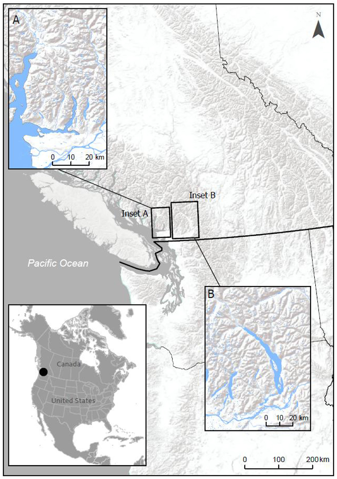
Figure 1. The study area—Tsleil-Waututh and Sts'ailes traditional territories.
There are more than 90 named Indigenous groups within the Salish Sea, each with their own ancestral settlements and homelands. All of the settlements were along navigable waterways, which connected people to one another for marriage, ceremony, exchange, and conflict. Settlements were also positioned to provide access to marine and aquatic foods, as well as inland areas, where people followed established trails to their temporary harvesting camps, lithic quarries, or went off-trail for hunting and ceremonial reasons. We have marshaled complementary lines of evidence1 for two of these named Indigenous groups, Tsleil-Waututh and Sts'ailes, including settlement histories, archaeological records, oral history, ethno-historic sources, and traditional use studies.
This research develops an integrated water-land model that highlights the relationship between canoe and overland travel and transport in shaping the social geography and historical identities of Coast Salish groups in two watershed systems. Our model is designed to show how long it would take residents of ancestral settlements to access surrounding lands and waters, to identify areas of frequent visits, which signaled entrenched territoriality (e.g., Elmendorf, 1974). Our study builds on and formalizes the seminal papers by Ames (2002) and Blake (2010) where they highlight the profound influence of watercraft on settlement subsistence systems and territoriality. It also advances a more “phenomenologically informed view of indigenous relationships to land and formulations of community” (Thom, 2009, p. 179), helping to reconcile Indigenous concepts of territoriality with the “boundaries” recognized by ethnographers, historians, and state institutions.
In a seminal paper, Ames (2002) highlights the profound impact of watercraft on hunter-gatherer settlement subsistence systems. While modeling of terrestrial hunter-gatherer land use patterns has been developed to quite a high degree of sophistication (Aldenderfer, 1998; Belovsky, 1987; Binford, 1980, 2001; Kelly, 1983, 1995; Lee, 1968, 1969; Lee and DeVore, 1968, 1976; Lovis et al., 2005; Morgan, 2008), similar modeling of canoe-reliant fishing-focussed marine oriented hunter-gatherer land use patterns is far less developed (see Blake, 2010; Byrd and Brandy, 2023; Supernant and Cookson, 2014). The parallel results of our separate Coast Salish cases suggest that the water-land model accurately represents pre-contact Coast Salish peoples' landscape/seascape use, and offers a useful tool in understanding how they regularly used their lands, and moved through their territories for food, materials, and ceremony.
Our study examines Tsleil-Waututh territory in Burrard Inlet (s e lilw e t) and Sts'ailes territory in the Harrison Watershed (Figure 1), which have well-documented settlement histories (Morin et al., 2018; Ritchie et al., 2024). Our long-term research partnerships with the Tsleil-Waututh and Sts'ailes also provides us with first-hand experience traveling on the waters, overland on trails, and familiarity with their respective oral histories and traditional knowledge, all of which underpin our analyses and interpretations.
We highlight two significant findings and implications of the integrated land-water travel model from ancestral settlements. First, there is close correspondence between our time-modeled use areas, and “real” activities documented through interviews (i.e., traditional use studies/TUS). That is to say, the distribution and density peoples' recorded modern harvesting activities are corroborated by the model. Second, we find that the aggregated activity areas around Tsleil-Waututh and Sts'ailes ancestral settlements corresponds with their respective asserted territories.
The territoriality of the kind that we describe has a key role in reinforcing group identity, differentiation, and interaction. In other words, our modeled harvesting areas clearly demonstrate that local, undoubtedly related villages had overlapping harvesting areas that would have brought people from neighboring villages into daily contact with one another. Such social proximity would have been structured by cultural rules to mediate access by local peoples. Similarly, these cultural rules of access would have undoubtedly included different rules of access by non-local peoples. In this manner a group identity is fostered by intensive levels of social interaction and shared and mediated local resource use, and this local identity is configured to similarly differentiate such a social configuration against other, non-local social configurations. Our findings may support research across the Northwest Coast, and in other places where people used the land but relied on the water for subsistence, travel, and transportation.
The primary goals of this research are to describe the daily foraging areas around villages (i.e., site catchments), and to explore potential aspects of territoriality between villages and groups of villages (i.e., tribal territories). And that is to say, to explore the relationships between local geography and canoe technology as structuring Coast Salish resource use and territoriality.
Coast Salish landscape and seascape use
Territoriality refers to all the ways that people communicated their territorial interests. In the Salish Sea, this included, for example, establishing settlements and houses, marking trails, rock art, constructing and maintaining clam gardens and fish traps, managing aquatic and terrestrial landscapes for food, building defensive sites, and through burial locations and distinctive burial styles (Springer and Lepofsky, 2019). Territoriality also includes daily activities and interactions that may not be visible archaeologically, that express people's connections and rights to the land and waters, by referring to named places, stories, harvesting, and travel.
For at least the last 3,000 years, many Coast Salish people in the Salish Sea lived in settlements comprised of large cedar plank houses, for part or all of the year (Burley, 1989; Grier, 2003; Lenert, 2007; Lepofsky et al., 2000; Matson and Coupland, 1995; Ritchie, 2010; Schaepe, 2009). Some of these villages were occupied year-round, and others were likely occupied during seasons other than winter (Coupland, 1991; Ham, 1982; Matson and Coupland, 1995; Mitchell, 1983; Morin et al., 2021b; Trost, 2005). Coast Salish villages—all of which are located on navigable waterways—are centrally important places in the region's social landscape. This is because the earliest villages were established in especially rich ecological locations by “First Ancestors,” who subsequent generations are connected to genealogically and by name. Successful villages were often occupied for millennia and expanded in size and importance over time. Villages were comprised of large households that operated collectively, but also functioned as social, economic, and political units. Like the villages they were part of, high-status households persisted over many generations because they inherited rights and privileges to the lands and resources. Lands and waters surrounding settlements were “regarded as property of that community” (Elmendorf, 1974, p. 270).
While people were anchored to their settlements, many also left them regularly to collect resources from other parts of their territory throughout the year (i.e., following a seasonal round) (Barnett, 1955; Mitchell, 1983; Suttles, 1951, 1955, 1968, 1987, 1990). In the spring, this included short forays to harvest cedar bark, bullrushes, fresh shoots, and eulachon; in the summer people often constructed mat lodges for longer trips to harvest and preserve salmon and berries; and in the fall, people positioned themselves at salmon fishing stations, and hunted deer, elk, and other game in interior areas. Large quantities of food and materials were transported back to main settlements where they could be stored for the winter. The enormous volumes of faunal remains found archeologically at village sites is clear that considerable food processing activities were also undertaken at the main villages themselves. Some Coast Salish groups traveled large distances to participate in spring, summer and fall salmon, herring, and eulachon fisheries. In part, this movement was facilitated by marriage alliances between households from neighboring watersheds. Drawing on ethnographic information, Kelly (1995, p. 128) found that the average “Gulf Salish” seasonal relocation was about 35 km. Tsleil-Waututh oral histories suggest seasonal relocations more in the range of 20–30 km distant from primary villages (Tsleil-Waututh First Nation and Alexander Heritage Consulting, 2001). Sts'ailes seasonal movements were probably more in the range of 10–20 km.
Perhaps the most significant facet of Coast Salish technology was the widespread use of dugout canoes of a variety of forms (Barnett, 1955; Lincoln, 1991; Suttles, 1951, 1990). Using these canoes allowed people to fish in offshore areas that they otherwise could not access, travel further on a daily basis to hunt, fish or gather, relocate their camps or villages with relative ease, and to transport very large quantities of resources from harvesting locations to winter villages (Ames, 2002; Blake, 2010). Suttles (1990, p. 462) describes five types of canoes for the Coast Salish, all dugout-type canoes carved from red cedar. The most typical canoe was the Coast Salish canoe, a family canoe, which was typically used for fishing and hunting that could vary from small two-person to about 10-person crafts (~12 m long) (Lincoln, 1991; Suttles, 1990, p. 462). For the purposes of this study, we are primarily concerned with canoes used for typical daily subsistence activities, that is the Coast Salish style canoes capable of holding about 2–10 people (Figure 2).
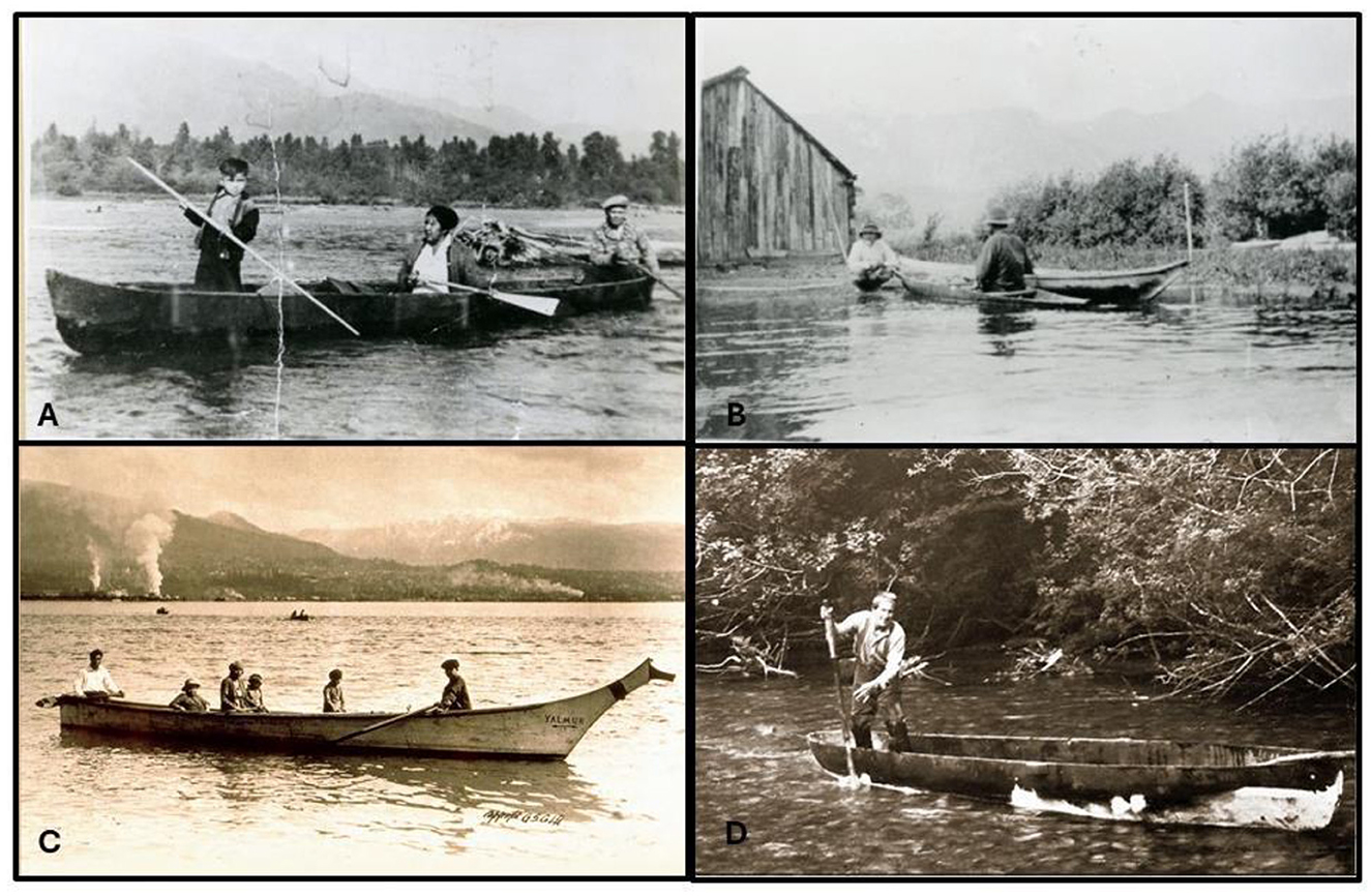
Figure 2. Various late 19th century and early 20th century Coast Salish canoes. (A) Sts'ailes Archives; (B) City of Vancouver Archives AM54-S4; (C) BC Archives H-04742; and (D) Tsleil-Waututh Archives.
All early historic and ethnographic descriptions of Coast Salish people emphasize their extensive use of canoes (Barnett, 1955; Dorricott and Cullon, 2012; Hayman, 1989; Jenness, 1955; Lamb, 1984; Wagner, 1933). Use of canoes for travel and resource harvesting was a fundamental aspect of traditional Coast Salish life-ways (Figure 2). Nineteenth century comments by Wilson (1866, p. 289) regarding Coast Salish canoes captures their predilection for canoe travel:
The Cowitchans have no horses, and their only means of locomotion are by foot, which they are not very fond of, and by canoe, which in a country like that of the lower Fraser, where forests are almost impenetrable from the dense underbrush, is by far the most convenient. The canoes of the Cowitchans range from fifteen to fifty feet in length, cut out of as single tree of fir or cedar, the largest size capable of holding some twenty people…
Some very common uses of canoes by Coast Salish people include: trolling for fish, night pit-lamping for salmon, hunting seals, sea lions or porpoises, spearing sturgeon, herring raking, duck hunting, traveling to and from clamming beaches, setting salmon nets, removing salmon traps from weirs, setting duck nets, setting branches to harvest herring spawn, traveling to and from hunting locations, traveling to and from fishing camps or stations, traveling between villages, and creating catamarans and transporting house planks between villages (Barnett, 1955; MacLachlan, 1998; Suttles, 1951, 1998). That is to say, canoes were used in the course of most subsistence activities and most travel.
Canoes were valuable because they required specialized knowledge and time consuming to construct. Some of the earliest historical descriptions of Coast Salish villages, such as Captain Vancouver's sojourn at the K'ómoks village of Ch'kwúwutn at Cape Mudge on Quadra Island, described 70 canoes beached in front of a village of 300–350 people (Lamb, 1984, p. 618; Newcomb, 1923, p. 82–83), suggesting about one canoe for every 4–5 people – or about one canoe per nuclear family. Given the differences in material wealth amongst historical Coast Salish peoples (Suttles, 1987), wealthier, larger families likely owned multiple canoes, perhaps one larger freight canoe and several smaller daily use canoes. We are not aware of any ethnohistoric information that indicates poor people did not have canoes of their own, but one could imagine such a situation where a poor family couldn't afford a large canoe, and perhaps had to occasionally borrow canoes from their kin to use. If families or individuals did not have access to canoes, they could have been forced into greater reliance on accessible terrestrial resources.
Building on the pioneering work of Smith (1940) and Suttles (1987, p. 210–220), Carlson (2010, p. 38–57, 109–112) has recently developed what is perhaps the most insightful model of Coast Salish territoriality in relation to the natural environment. The foundation of this model is that individual rivers, watersheds, or their equivalents were populated by clusters of associated villages that were socially and cultural linked to one another more so than their individual linkages with other clusters (Carlson, 2001, p. 24, 31, 2010, p. 110, see also Suttles, 1987, p. 210). Each cluster of villages, or tribal center usually had one much larger settlement (headquarters or town) (Carlson, 2001) that was populated by the leading hereditary elite and included at least one extra-large potlatch house (see Miller, 1999, p. 10, 82). Tribal centers were then situated along an owned tribal watershed and members of each tribe held exclusive acquisition rights to all the resources of that watershed (Carlson, 2001, p. 24–25). The boundaries between adjacent tribal centers were located approximately at the peak of any mountains between such watersheds (Carlson, 2010, p. 110). In our experience working with different Coast Salish peoples, we find Carlson's (2010) watershed model to largely hold true. Further, in both Burrard Inlet and the Harrison River Watershed, we have archaeological data documenting the long-term growth and occupation of settlement clusters in respective watersheds over 3,000 years that attests to the long-term stability of this pattern (Morin et al., 2018; Ritchie et al., 2024). It is our perspective, based on both our understanding of Coast Salish epistemology, ethnohistory, and the results of our analyses below, that earliest village or villages in a watershed (the First Ancestors) similarly established the approximate tribal territory, and that subsequent population growth and founding of new villages only slightly expanded that territory.
Least cost analysis and canoe travel
Following White and Surface-Evans (2012), we model Coast Salish landscape and seascape use using a body of methods and theory called “Least Cost Analysis” (LCA) predicated on Geographic Information System (GIS). Least Cost Analysis assumes economizing behavior, i.e., maximizing energetic returns on foraging trips from a central place (Orians and Pearson, 1979). Clearly, the farther one travels to harvest resources, the greater energy is expended procuring those resources, the less net energetic return (Kelly, 1995, p. 131–133). Therefore, this analysis assumes that, all other things being equal, less-distant resources would have been preferentially targeted over more distant resources (Roper, 1979, p. 120–121). There is copious ethnographic support for this principle (Binford, 2001; Kelly, 1995). Clearly there are upward limits on how far people are willing to travel on a daily basis for subsistence activities (Kelly, 1995, p. 131–133, 129–147). As a rough benchmark, when resources within about a 2-h travel radius were depleted, hunter-gatherers tend to relocate their camps or villages (see Harako, 1981, p. 535; Morgan, 2008; Sahlins, 1972, p. 33; Tanaka, 1980, p. 66; Tindale, 1972, p. 244–245; Vincent, 1984).
In practice, LCA calculates the cost (in time or energy) of moving across the landscape. This is based on the assumption that people economize their effort when traveling (Surface-Evans and White, 2012). Because water and land have very distinctive costs of traveling (e.g., walking carrying a load or canoeing carrying a very large load and or many people) LCA methods can be used to model travel costs on land and water. Similarly, landform topography has a profound impact on the directionality of foot travel, as economizing behavior predicts that people chose the quickest or most energy efficient route of travel, rather than the most direct route. This later point is particularly salient with regards to the study area, as here the Cascade Mountains rise rapidly from sea level to about 2,000 m in < 5 km inland.
It is clear that almost all hunter-gatherers had to periodically relocate their camps or villages to areas where resources were locally available (Binford, 2001; Kelly, 1995). Coast Salish peoples clearly practiced a seasonal round wherein they relocated several times a year (~1–5) (Kelly, 1995, p. 125; Mitchell, 1983) to mass harvest and preserve seasonally hyper-abundant resources, such as herring, shellfish, and, of course several species of salmon (Barnett, 1955; Suttles, 1951, 1968). Coast Salish peoples also made intensive use of a very wide array of additional relatively local resources including land and sea mammals, shellfish, bottom fish, sea birds/ducks, berries, and geophytes/tubers (Barnett, 1955; Franck, 2000; Lepofsky et al., 2007; McLay, 1999; Mierendorf et al., 1998; Mierendorf, 1999; Suttles, 1951). Coast Salish people clearly pursued both collecting and foraging strategies resources (Binford, 1980). For the purposes of this paper, the season of occupation of the villages considered is not particularly important, as our focus is on the site catchment area surrounding each village. We do note, however, travel during winter months could range from dangerous to impossible for days at a time as Pacific storms pass through the region.
Daily foraging radii are not well-described in the Coast Salish ethnographic literature but undoubtedly consisted of activities such as gathering clams or other shellfish, berries or other plant products, trolling offshore for salmon and rock fish, canoe-based duck and sea mammal hunting, and canoe trips to specific locations on the land for hunting and trapping. Undoubtedly, daily foraging trips were also timed to take advantage of the local tides and currents. As mathematically described by Kelly (1995, p. 140–147), the 2-h foraging radius (~6 km for terrestrial hunter-gatherers) represents the maximum distance where the minimum return requirements (energy captured vs. energy expended) can still be achieved. We suggest that a 2-h foraging radius for canoe borne Coast Salish people would be less than their maximum effective foraging range because of the bulk transport capabilities of canoes (Ames, 2002).
Archaeologists have been modeling site catchments in Coast Salish territory for some time. In one case, Bernick (1983) identifies specific resources recovered from a shell midden on the Little Qualicum River and describes the distance to the most proximate source of those resources recovered from the midden site. Bernick (1983, p. 189–192) suggests that most of the food remains from that midden would have been available within 10–30 min travel (by foot) to obtain them. Along similar lines, Lepofsky et al. (2007) interpret the materials recovered in excavations of three village sites in eastern Burrard Inlet in terms of “catchment zones.” In this case, Lepofsky et al. (2007) categorized those identified resources (faunal, floral and lithic) into local (< 10 km), regional (10–100 km), and distant (>100 km) catchment areas. One of the major conclusions of Lepofsky et al. (2007) was that the overwhelming majority of observable/identifiable resources were obtained locally (within 10 km), and social relationships were strongly oriented to other communities within the Inlet.
The Burrard inlet and Harrison watershed study areas
Building on these previous studies, this research develops a model of site catchments for pre-contact Tsleil-Waututh and Sts'ailes (Coast Salish) villages in s e lilw e t(Burrard Inlet) and the Harrison Watershed, respectively.
The Sts'ailes are a Coast Salish tribe who have lived within their Harrison Watershed homeland since glaciers retreated over 11,000 years ago (Figure 3). Historically and today, the Sts'ailes people are part of a geographically expansive Coast Salish society in which groups from great distances were linked through kinship, language, trade, intermarriage, ceremonies, and stories. Geographically located on the largest lake in the southern Coast Mountains and navigable rivers, the Sts'ailes also shared a frontier with Interior Salish groups such as the St‘at‘imc and Nlaka‘pamux to the north and east. The Sts'ailes were recognized as helping to bridge language and cultural differences between groups on the Coast and Interior, easing often hostile interactions, and maintaining trade relations.
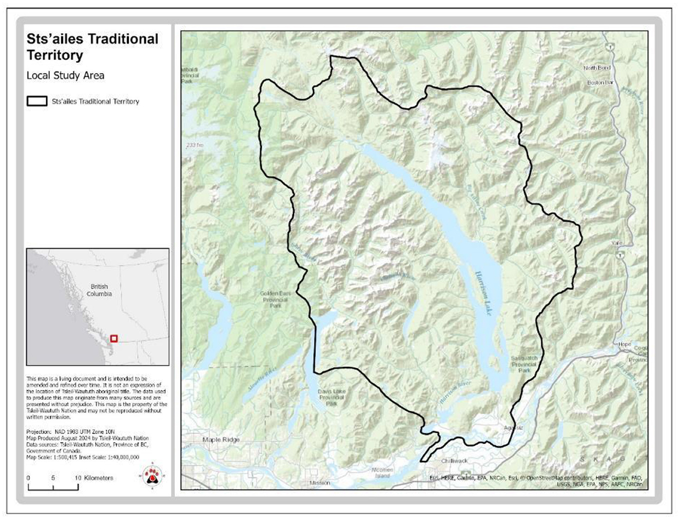
Figure 3. Sts'ailes traditional territory.
Waterways such as rivers, lakes and sloughs played a major role in structuring the physical and social landscapes of the Sts'ailes (Figure 4). It was around these waterways that the majority of the Sts'ailes and their neighbors lived, relying on them for all aspects of their daily lives. These waterways acted as social corridors connecting people from great distances creating a network of relations that spanned the entire Coast Salish world and beyond (Carlson, 2001). The most important navigable waterways within Sts'ailes territory were Harrison Lake and Harrison River, together extending over 80 km. Flowing into Harrison Lake at its northern end is the Lillooet River, which in turn connects to a series of lakes and rivers that are navigable all the way to the mountains enclosing the Pemberton River Valley. The next largest waterways flowing into these main bodies of water include Silver River and Mystery Creek on Harrison Lake, and the Chehalis River on the Harrison River. Silver and Mystery are navigable for several kilometers before the gradient steepens and cascades prevent the upriver movement of people and salmon. The gradient of the channel, and the narrowness of the canyon that the Chehalis River flows through makes make it too swift for navigation beyond the apex of the alluvial fan, but runs of salmon make it all the way to Chehalis Lake and beyond, over 25 km into the valley. Smaller creeks—some of which were navigable for a short distance—were abundant and provided important corridors to lakes in the hills and mountains.
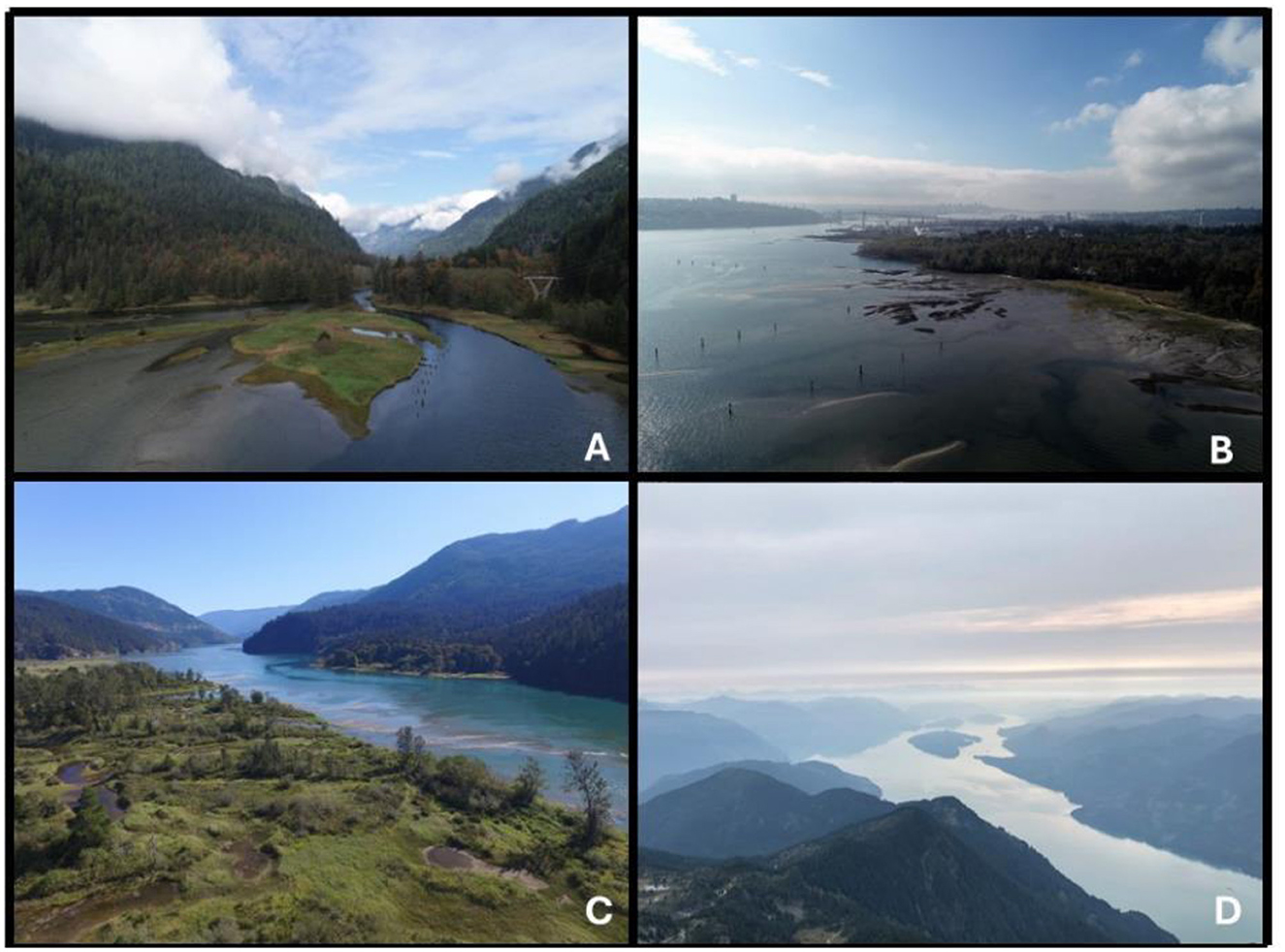
Figure 4. Photos illustrating the topography of the study areas. (A) Looking north up the Indian River (Tsleil-Waututh territory). (B) Looking west out of Burrard Inlet (Tsleil-Waututh territory). (C) Looking north up the Harrison River (Sts'ailes territory). (D) Looking north up Harrison Lake (Sts'ailes territory).
The physical landscape of Sts'ailes territory is largely defined by Harrison Lake, which fills a deep chasm that cuts through the Coast mountains in a wide valley (over 70 km in length and 3 km wide) that divides the Lillooet Range of mountains on the east and the Clark Range on the west. Harrison Lake, which is only about 10 m above sea level is over 150 m deep in places and is notoriously treacherous for boats when the northern winds arise (Figure 4). Surrounding peaks rise to true alpine over 2,000 m above. Because of the many mountains, valleys, and drainages, the terrain has always been challenging to move easily across. Trails in the past, as they are today, tend to be along valley bottoms, along terraces shaped by downcutting waterways, and ridges. Although well groomed trails connected people to the most important parts of their territory and their neighbors, smaller trails and tracks were frequently used as well, especially for hunting.
Tsleil-Waututh are similarly a Coast Salish tribe with a territory centered on s e lilw e t(Burrard Inlet) and hold oral histories linking themselves to the first people to inhabit the region (see Figure 5). Despite being a socially distinct Coast Salish people, Tsleil-Waututh were closely linked to their H e ǹq̀ e miǹ e m relatives living along the Lower Fraser River, and their Squamish relatives in Howe Sound in the Squamish Valley. The primary geographic feature of Tsleil-Waututh territory is Burrard Inlet, inclusive of Port Moody Arm and Indian Arm (Figure 4). Pre-contact Tsleil-Waututh villages are known from the archaeological record and oral histories to span both shores and heads the inlet, with a notable cluster of villages in eastern Burrard Inlet near the junction with Indian Arm. Many of these villages were located within a few kilometers of each other. Some of these villages, especially in the western portion of Burrard Inlet, were jointly occupied with other Coast Salish peoples.
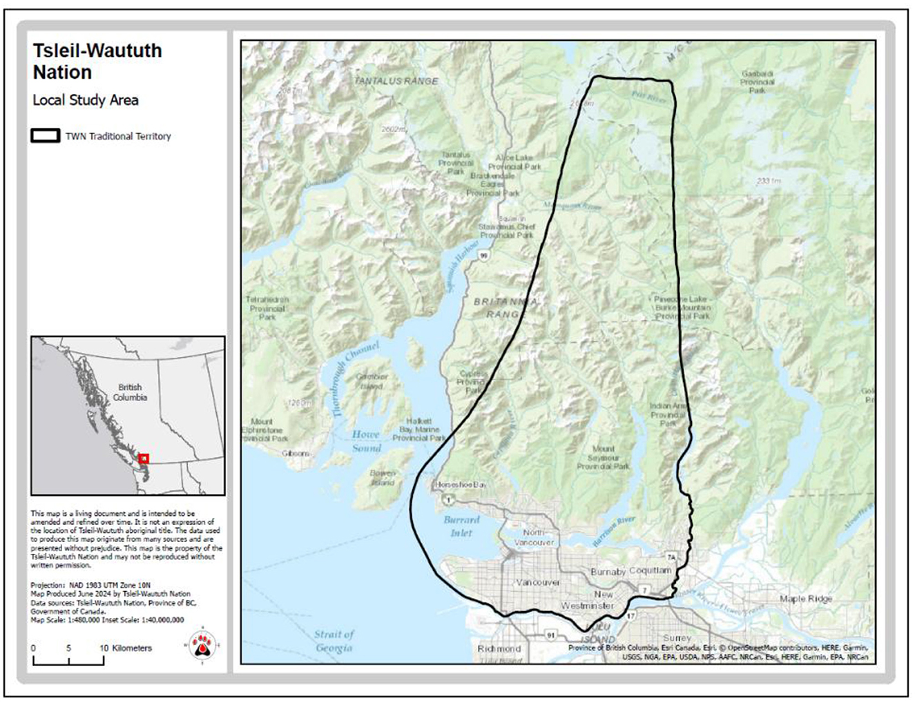
Figure 5. Tsleil-Waututh's statement of intent (SOI) map used in treaty negotiations.
Trails extending from the Tsleil-Waututh villages on the shores of Burrard Inlet lead to the alpine headwaters of this area (Crease, 1863). To the south of Burrard Inlet, the lands are now part of Greater Vancouver are flatter, and generally drained by small streams and lakes. Tsleil-Waututh territory extends south in this direction toward the Fraser River. Several Indigenous trails are documented here linking Burrard Inlet to the Fraser River (Richards, 1859–1860).
Burrard Inlet is bounded by steep mountains, up to 1,800 m high, to the north that are drained by several small rivers and streams, including the Capilano, Seymour and Indian Rivers (Figure 4). For the purposes of this paper, the authors have used Tsleil-Waututh's statement of intent (SOI) map, which was developed for treaty negotiations. In this geographic context, traditional Tsleil-Waututh travel was strongly structured by canoe travel along the east-west axis of Burrard Inlet and the north-south axis of Indian Arm, and by foot travel that following waterways that drain into Burrard Inlet. This canoe travel would have included not only daily hunting, fishing, clamming, and gathering activities, but also transporting large volumes of dried sockeye salmon from the Fraser River and large volumes of smoked chum salmon from Indian River back to the primary Tsleil-Waututh villages around eastern Burrard Inlet. Foot travel, on the other hand would have likely included hunting, berry gathering and other activities undertaken by small groups of people both at areas immediately surrounding villages, and at areas requiring overnight camps somewhat distant from villages. The geography of Tsleil-Waututh and Sts'ailes peoples are not necessarily typical of all Coast Salish peoples, but include the major features of open waterways, smaller rivers, and variable steep mountains and hills that dominate the Salish Sea region.
Selecting the data and parameters of the least cost analysis
Developing a region specific LCA model required obtaining digital spatial information describing the local geography, creating travel cost rasters, and selecting points of origin from which to run the model. The sections below describe the selection of points of origin (village sites), the digital spatial information, and the development of travel cost rasters.
In this model, we use documented Tsleil-Waututh and Sts'ailes villages as the points of origin for the model. The location of numerous Coast Salish village sites are known through both archaeology and oral histories in Burrard Inlet and the Harrison Watershed (Hill-Tout, 1904, 1905; Charlton, 1972, 1974, 1980; Lepofsky et al., 2007; Morin, 2014; Morin et al., 2018, 2021b; Ritchie, 2010; Ritchie et al., 2016; Suttles, 1990). Most of these villages were strongly influenced by seasonal activities, but current data from both the Tsleil-Waututh and Sts'ailes villages indicates more or less year-round occupation (Morin et al., 2021b; Ritchie and Lepofsky, 2020; Ritchie et al., 2024).
Based on ethnographic sources archaeological evidence, there are at least 27 ancestral Sts'ailes villages within the Harrison Watershed. Of these, two were located on Chehalis Lake, four on the lower Lillooet River near the confluence with Harrison Lake, six on Harrison Lake, and at least 15 on the Harrison River. The confluence of the Harrison and Chehalis Rivers is the social, cultural, and ecological heart of Sts'ailes territory. In this study, we first look at all of Sts'ailes' ancestral villages together to examine issues of land use, territoriality, and travel routes, followed by an analysis of Sts'ailes villages on the Harrison River where more is known archaeologically. Ancestors of the Sts'ailes have been living in large plank houses at the confluence of the Harrison and Chehalis Rivers from at least 3,000 years ago, with the number of houses and villages growing over time. By 1,500 years ago there were at least 10 villages with over 75 houses, and by 800 years ago there were 15 villages that were occupied throughout the year, with people living in both winter pithouses and plank houses.
Similarly, based ethnographic and archaeological evidence, there are at least 17 ancestral Tsleil-Waututh villages around the shores of Burrard Inlet. About half of these villages are located near the junction of Burrard Inlet and Indian Arm, and the others extend across the breadth of the inlet. All evidence suggests that Tsleil-Waututh ancestors lived in multiple plank houses at these villages. Tsleil-Waututh's primary settlement or headquarters, t e mt e míxwt e n (at Belcarra Park) has evidence of occupation for about 3,000 years, and this occupation was largely based on a sustainable local chum salmon fishery (Efford et al., 2023; Morin et al., 2021b,a). There is a general increase in the number of occupied villages in eastern Burrard Inlet, peaking in the centuries immediately prior to First Contact with Europeans in 1791/1792 CE (Morin et al., 2018).
Digital spatial information
Several layers of information and inputs were required to calculate least cost catchments of the Coast Salish village sites. The data used in this LCA are from two primary sources: the digital elevation (DEM) data were obtained from GeoBase (a Canadian government initiative), and the hydrology data (ocean, lakes, rivers) for British Columbia came from Data BC (Government of BC 2013) and the Washington hydrology data came from the US National Hydrology DataSet produced by the US Geological Survey (USGC, 2013). The original raster resolution for the DEM 18.8 m and was coarsened to 20 m.
Creating travel cost rasters for landscapes and seascapes
To calculate travel time over land we used the Tobler Function (Tobler, 1993) which has been used in numerous archaeological applications of least cost distance calculations (e.g., Aldenderfer, 1998; Conolly and Lake, 2006; Harris, 2000; Howey, 2007; Livingood, 2012; Sakaguchi et al., 2010; White, 2012). We assumed that important travel routes (i.e., linking places people would often visit) would have had established trails, and so we used the “on trail” version of the Tobler Function, but not incorporate any trails into the model. In addition, we did not incorporate how vegetation would have impacted the speed of travel nor did we incorporate additional time required to cross streams. Because of the urban development of most of the Tsleil-Waututh study area, modeling pre-contact “natural” vegetation and many stream courses is impossible. If we could integrate these layers of data, while we would not expect them to alter LCA calculations very much, we would expect them to influence the LCA calculations primarily when viewed at very high resolution (i.e., zoomed-in).
The least cost catchment by foot was derived using a modified Tobler's (1993) Function; and Map Aspects website (http://mapaspects.org/node/3744). The land cost raster was created using a slope raster from a 20 m DEM which was masked to be just land (excludes ocean, lakes >3 ha, and impassable rivers) and buffered by 10 m for the 20 m DEM to remove gaps along the coastline. Then, the Tobler Function was modified to calculate the time it takes to cross a distance of one meter. Because the original Tobler Function is without units (rise/run), it was modified to use degree slope so that positive and negative slopes produce different rates of travel. Further, as we wanted to obtain time for our LCA, rather than speed, we used the inverse of the Tobler Function equation. This modified Tobler Function was then inputted into the Raster Calculator to generate the land cost raster within our GIS model. To generate least cost catchments, a mask of the study area was created (excluded impassable water bodies and distant lands) to reduce computer processing time. Then, the Path Distance Tool was run using villages as starting points, an 20 m DEM for the input surface and vertical rasters, the Tobler table for the vertical factor, and finally the earlier created mask to spatially constrain the output. The contour tool was then used to create isochrones of equal travel time from villages as origin points.
The least cost catchment by canoe was derived from estimation of canoe travel speeds from experimental, historical and cross-cultural data. As Livingood (2012) explained “there are no well-established analogs to the Tobler (1993) formula for estimating the speed of canoe travel.” Cooper (2010) was able to overcome this issue and develop least cost catchment areas in coastal Cuba. In this case, Cooper (2010, p. 130) created a surface cost raster for water travel based on experimental local canoe travel speeds. In a riverine setting, Livingood (2012, p. 179–180) calculated canoe travel speeds—upstream and downstream—based on historic and modern recorded canoe travel times and then used these data to develop a canoe travel speed algorithm. This issue of calculating canoe travel based on local technologies and conditions is critical to accurate reconstructions of past travel, as canoe size, volume, speeds, and tolerance for poor weather vary significantly (Fauvelle and Montenegro, 2024; Gustas and Supernant, 2017; Peterson, 2022; Shaw, 2018; Slayton, 2020).
Given this absence of established methodologies for calculating least cost pathways/catchments over water, we also developed a surface cost raster based on historical and experimental travel speeds in the study area. In our study area—Burrard Inlet and the Sechelt Inlet System—Coast Salish canoe travel would primarily have to contend with strong tides. Below, we describe how we developed a surface cost raster for seascape travel, and discuss the limitations of our model.
There is a reasonable body of documentation of canoe travel speeds for both riverine environments where the flow of the river strongly influenced travel speeds (e.g., 2–5.6 km/h upstream and 2.4–13.8 km/h downstream) (Livingood, 2012), and for marine environments where tides and weather strongly influence travel speeds [e.g., 2.7 km/h to 6.5 km/h (Blake, 2010); 4.4 km/h slower average speed and 6.5 km/h in favorable conditions (Ames, 2002); 2.7 km/h in bad weather and 4.5 km/h in good weather (Croes and Hackenberger, 1988)]. In large canoes with about 10 paddlers, missionaries describe traveling between 7–10 km/h over about 10 h within the study area (D'Herbomez, 1884; Morice, 1880). The slower travel rates (7 km/h) are associated with traveling about 25 km up the Fraser River (against the current).
Recent studies in the Prince Rupert area (Gustas and Supernant, 2017; Supernant and Cookson, 2014) used a value of 4.5 km/h for canoe travel time (citing Ames, 2002, p. 31) as an appropriate value for short canoe trips. Our review of relevant information suggests that this value is too low.
As this study focuses on canoe travel in marine environments in the Coast Salish region, historic estimates (e.g., Castile, 1985, p. 191; D'Herbomez, 1884) and local experimental data (Morin and Hunt, 2014) regarding canoe travel in the Coast Salish area are privileged over canoe travel speeds from elsewhere where different environmental conditions and canoe technologies were present. We chose to rely on Ames' (2002, p. 30) calculation, based on historical information (Castile, 1985) of Coast Salish canoe speed of 6.5 km/h under favorable conditions. Based on our review of the available data (7–10 km/h), and our experimental canoeing results (7–8.5 km/h) (Morin and Hunt, 2014),2 we think that 6.5 km/h is a conservative estimate of canoe travel under favorable conditions. Indeed, one could argue that traveling short distances was done at a faster pace than traveling long distances (contra Ames, 2002, p. 30; Gustas and Supernant, 2017; Supernant and Cookson, 2014), as people could easily maintain higher rates of speeds over shorter distances (sprints rather than marathons), especially so if travel was timed with the tide and currents.
Clearly, there are numerous variables that affect canoe travel time. These include: (1) size of the canoe and its cargo, (2) and the number and experience of the paddlers (“pullers” in modern Coast Salish terminology), (3) tides, (4) river currents, (5) wind, and (6) weather. Perhaps the most important, and completely unquantifiable variable effecting the speed of canoe travel would be the Traditional Ecological Knowledge (TEK) carried by the expert pullers whose ancestors had thousands of collective years traveling this seascape. Undoubtedly, using this information, most travel was timed in consideration of the tides, winds, and currents to maximize travel speed while keeping effort moderate. As these are far too many variables to integrate into a single useful model, we have instead chosen to use conservative estimates of average travel speed of a typical small Coast Salish canoe (2–10 person) as 6.5 km/h under good travel conditions (no wind and slack tide).
To generate the seascape least cost catchment, a polygon of all navigable water was created, and then converted into a raster (20 m cell size to match DEM) and given the value of the time it takes to cross 1 m (0.00015384615 h) based on our average canoe travel time of 6.5 km/h (Ames, 2002). Then the Path Distance Tool was run using villages as starting points, and the water raster as the cost raster. The contour tool was then used to create isochrones of equal travel time.
Because ArcGIS is not able to deal with both land and canoe travel simultaneously (see Livingood, 2012), two cost rasters (land and water) were created separately and then combined before running the Path Distance Tool. Perhaps most notably, this model treats all water as equal, e.g., it does not simulate tides or other currents which we know were major factors in influencing the timing of canoe travel and the speed by which one could travel. Another weakness of this model is that it assumes one can switch from water travel to land travel at any point along the coastline. While this is generally true for much of the present study area, there are rocky bluffs and cliffs, especially along Indian Arm in the Tsleil-Waututh area, where such switching between modes of transport is unfeasible because there are very few locations for landing a canoe. To combine the landscape and seascape cost rasters, the Mosaic to New Raster tool was used with the mean mosaic operator. Finally, the Path Distance Tool was run to generate cost catchments using villages as starting points and the combined landscape and seascape cost rasters as the cost surface. Finally the contour tool was used to create isochrones of equal travel time around such origin points.
To create aggregate cost catchments, i.e. showing the travel times from multiple sites/villages at the same time, first the cost catchments were created as explained above. Then, the Mosaic to New Raster Tool was run using “minimum” as the mosaic operator to merge all the cost catchments together while selecting the minimum value for each cell. That is to say, the cost catchments were calculated independently for all village sites within the study area, then mapped together to describe the aggregate cost catchment for all such villages.
Assessing the accuracy of the model
While all of the variables used in this model are derived from published and well-established sources (e.g., Ames, 2002; Tobler, 1993; White and Surface-Evans, 2012), it is worthwhile to assess the accuracy of the model. To do so, we compared recorded travel times for foot travel along well-used trails within the study area, and canoe travel across Burrard Inlet/Indian Arm. For landscape travel, our model achieved very accurate predictions of reported hiking times (Morin and Hunt, 2014). More specifically, our model predicted travel times that deviated from reported hiking times by about 0% for short trails (that is perfect prediction of average hiking time), to a difference of about 37% for much longer trails (10–12 h) (Morin and Hunt, 2014). Overall, we suggest that this model does accurately predict past travel times, and speaks to the utility of Tobler (1993) Hiker Function.
To evaluate the accuracy of 6.5 km/h average canoe travel speed used in our least cost analysis model, we undertook our own canoeing experiments and calculated travel speeds within s e lilw e t/Burrard Inlet (Morin and Hunt, 2014). In our experiments, we used a 14–person fiberglass dugout style canoe (~210 kg), and with 8 Tsleil-Waututh pullers (paddlers) and one skipper (captain). This canoe would be about as large as the largest Coast Salish family-owned canoes, but much smaller than West Coast freight canoes. On two occasions, we paddled between two relatively distant settlement sites in Burrard Inlet, from xweyaw e θ e n/Cates Park to ʔ e nlilw e tał at the mouth of Indian River (~21–24 km, depending on the route). We should note that while these Coast Salish pullers were all moderately experienced, they had not trained together as a team. We are certain that more experienced pullers would achieve faster rates of travel. In one experiment we traveled against the tides and achieved overall travel rates of about 7.1 km/h, in the other we traveled with the tides and achieved overall rates of 8.4 km/h. Our fastest recorded travel rate was about 33 km/h, but we could only sustain such speeds for a few min. Clearly, in both experiments, we out-performed our modeled rate of 6.5 km/h (by 0.6 and 1.9 km/h). However, this comparatively large canoe was paddled by nine people, probably more people than would typically be traveling together for harvesting resources in the vicinity of one's settlement. These modern Coast Salish people's paddling abilities are undoubtedly but a shadow of their ancestor's abilities. As described above, in the past Coast Salish peoples used canoes nearly daily, and for most of their regular activities. We suggest that our modeled rate of canoe travel at 6.5 km/h seems to be an accurate, if not conservative estimate of regular Coast Salish canoe travel rates. Based on these evaluations, we feel that both our terrestrial model and modeled canoe speeds are accurate reflections of traditional travel times in Burrard Inlet and the Harrison Watershed.
Results: Coast Salish village catchments
Using the parameters described above, we created a LCA model and created maps of the least cost catchments for all the Tsleil-Waututh and Sts'ailes villages. Additionally, we created “aggregate least cost catchments” that combine the individual village catchments into representation of the sum of all such tribally affiliated villages. Because these data are highly visual, we make extensive use of maps and description of those maps in the following discussion. Below, we use a few examples of villages from Tsleil-Waututh and Sts'ailes territories to describe the general results of this LCA modeling.
Tsleil-Waututh village catchments—Burrard Inlet
In Tsleil-Waututh territory, we consider the LCA results for two contact-era villages and archaeological sites—Ɂǝniĺwǝtał/Indian Reserve 4 at the mouth of Indian River, and sǝłilwǝtał/Tsleil-Waututh's primary modern community at Indian Reserve 3—the aggregate least cost catchment for all Tsleil-Waututh villages. These examples illustrate several features of this modeling that help conceptualize traditional Coast Salish travel and resource harvesting.
The site catchment area modeled for Ɂǝniĺwǝtał at the head of Indian Arm is strongly structured by the steep topography of the Indian Arm fjord and the Indian River Valley (Figure 6). The ease of canoe travel south in Indian Arm, and the relative ease of walking across flat terrain in the Indian River Valley create a site catchment area (2-h isochrone) that is elongated north-south. It clearly takes much more time and effort to reach the relatively close mountain tops than much more distant locations along the shores of Burrard Inlet (Figure 6). Further, the relatively low gradient streams are invariably the most efficient routes inland and to higher elevation areas. The modeled catchment area for Ɂǝniĺwǝtał clearly illustrates the strong influence of topography on foot travel and the advantages of canoe travel over foot travel.
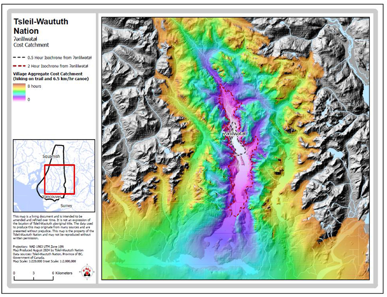
Figure 6. Results of LCA modeled for Ɂǝnilwǝtał.
Next, the settlement of s e ĺilw e tał is located on the north shore of Burrard Inlet, adjacent to a large, productive intertidal area and estuary, and several small salmon streams, about 3 km west of Indian Arm (Figure 7). The site catchment for (the 2-h isochrone) for sǝłilwǝtał is roughly oval in shape, and extends from First Narrows to the head of Port Moody (Figure 7). On water, canoe travel is primarily limited to an east-west axis. On land, travel is clearly constrained by the steep Cascade Mountains to the north, and relatively unconstrained by the gentle topography south toward the Fraser River. Beyond the 2-h isochrone, foot travel from sǝłilwǝtał is strongly constrained by the topography of the mountains and valleys, with the valley bottoms acting as natural conduits for travel (Figure 7). Because sǝłilwǝtał is located in close proximity to 5 other Tsleil-Waututh villages around eastern Burrard Inlet, its site catchment (2-h isochrone) is 87% overlapped by its nearest neighboring, and contemporaneous settlement, only about 2 km to the east. This implies that cultural rules of resource access, rather than only proximity, must have structured past Tsleil-Waututh resource harvesting and management activities.
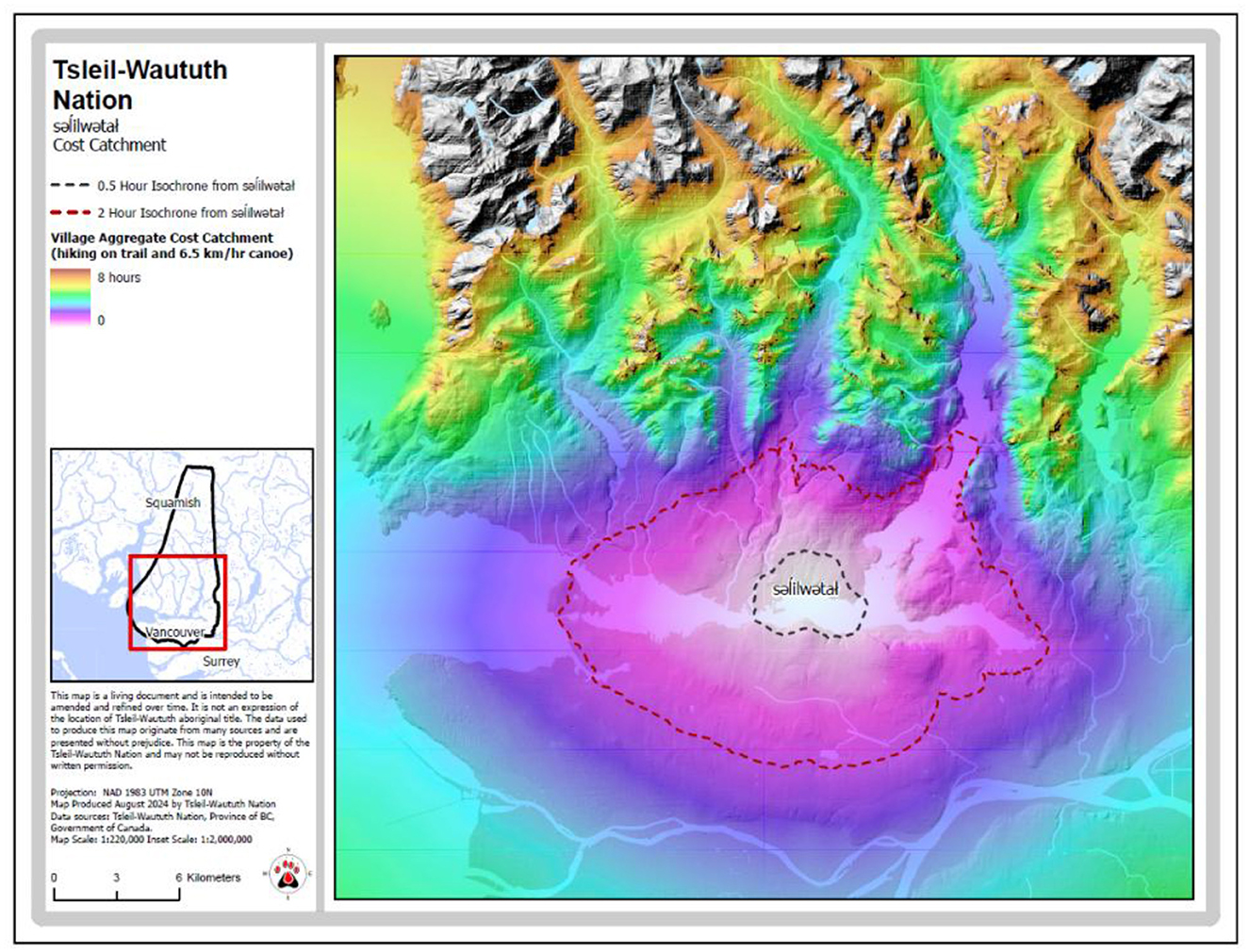
Figure 7. Results of the LCA modeling from sǝlilwǝtał.
To describe the scope of landscape/seascape use from all Tsleil-Waututh villages, we summed the individual site catchments modeled for each settlement into a single map that we call the aggregate site catchment (Figure 8). For the sake of simplicity, this map assumes contemporaneity of all villages.3 While many of these villages are clustered closely together around eastern Burrard Inlet, the maximum distance between any two Tsleil-Waututh villages is 44 km, with an average distance of 14 km between all villages. In terms of travel time, there is a maximum 6.7 h travel between the most distant villages, and an average 2.2 h travel between all villages. Within this wide spread however, several villages are located less than about 45 min away from each other. When observing the aggregate site catchment, it is clear that collectively, the inhabitants of these villages could have, and would have accessed all the waters of Burrard Inlet, and the area surrounding it on near-daily basis, as part of their regular harvesting and socializing activities. The relative hinterlands, located more than 2-h distant from the villages, would have also been regularly used, but primarily during longer foraging trips, and involving camping overnight.
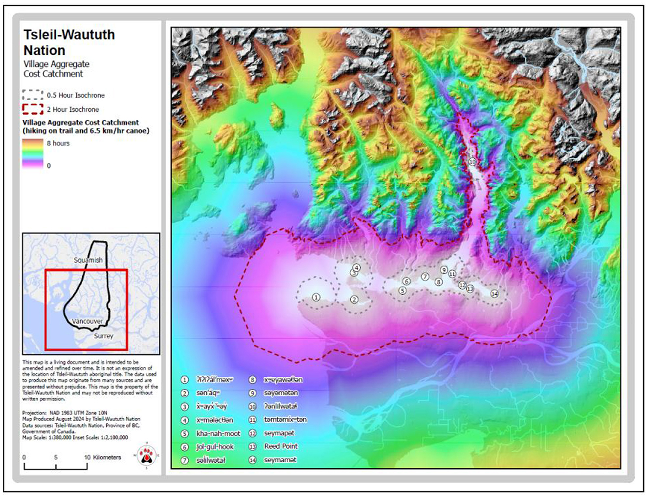
Figure 8. Aggregate cost catchment for all modeled pre-contact Tsleil-Waututh villages.
Sts'ailes village catchments—Harrison Watershed
Ancestral Sts'ailes villages were situated on navigable waterways throughout their territory, providing access to all parts of it. The distributed nature of these villages also meant that different branches of the Sts'ailes tribal group interacted more of less frequently with different groups, including the St'át'imc to the north, Nlaka'pmux and Skawahook to the east, and Sq'éwlets and Pilalt to the south.
The spatial proximity of villages within the Harrison Watershed supports ethnographic information that these villages were socially interconnected (Boas, 1894; Hill-Tout, 1904).4 Villages on Harrison Lake, Harrison River, and the lower Lillooet River were within a short paddle from the next closest settlement, with the average travel time between these villages around 15 min (Figure 9). Several of the villages are inter-visible with one another, reinforcing their daily social connection. Our model of land and water use by Sts'ailes people reveals how the distribution of villages supported good access to nearly the entirety of the watershed, and Sts'ailes' asserted traditional territory. When compared with the patterning of archaeological sites and traditional use activities, it is clear that the model is a good measure for the relative intensity of landscape use.
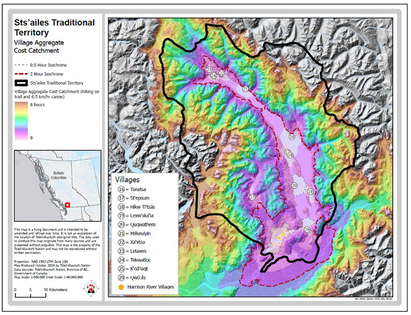
Figure 9. Aggregate cost catchment for all modeled pre-contact Sts'ailes villages.
Waterways and surrounding areas were used most intensively for all activities. Nearly all the most important landmarks—including transformer rocks and pictographs—are visible from canoes as people move away from the main settlement areas on the Harrison River and Harrison Lake. These landmarks are embedded with history and teachings reminding people how they should live in relationship with one another, the land, water, and other living species. Other documented sites that are within a short paddle from ancestral Sts'ailes villages include seasonal and temporary camps, lithic quarries, fishing, hunting, and harvesting places.
Mid-elevation valleys, ridges, terraces, and lakes were regularly used for travel, hunting, harvesting, and ceremonies. Traditional use datasets reveal that movement and activities in these places is frequent throughout much of the year, even in the winter. Archaeological sites are nevertheless still relatively few in number away from the waterways because people would rarely stay in one place for more than a few days at a time. The most common site that we have physical evidence of is cedar bark harvesting, and these are abundant. Alpine areas were also used regularly, but more seasonally, because of the snow. Principal activities in the alpine that we know about and have evidence for include berry harvesting, mountain goat hunting, and quarrying stone. People also traveled to the alpine for ceremonial/spiritual reasons.
Sts'ailes settlement catchments: Harrison River
Because of the large population of Sts'ailes people that lived at the confluence of the Harrison and Chehalis Rivers, the surrounding lands and waters were extensively used, managed, and transformed (Figure 10). Some of the most important resource locations, for plants, fishing, and stone quarrying, are located under 1 h of travel from this constellation of villages, which is likely one reason why people could live here year-round for thousands of years.
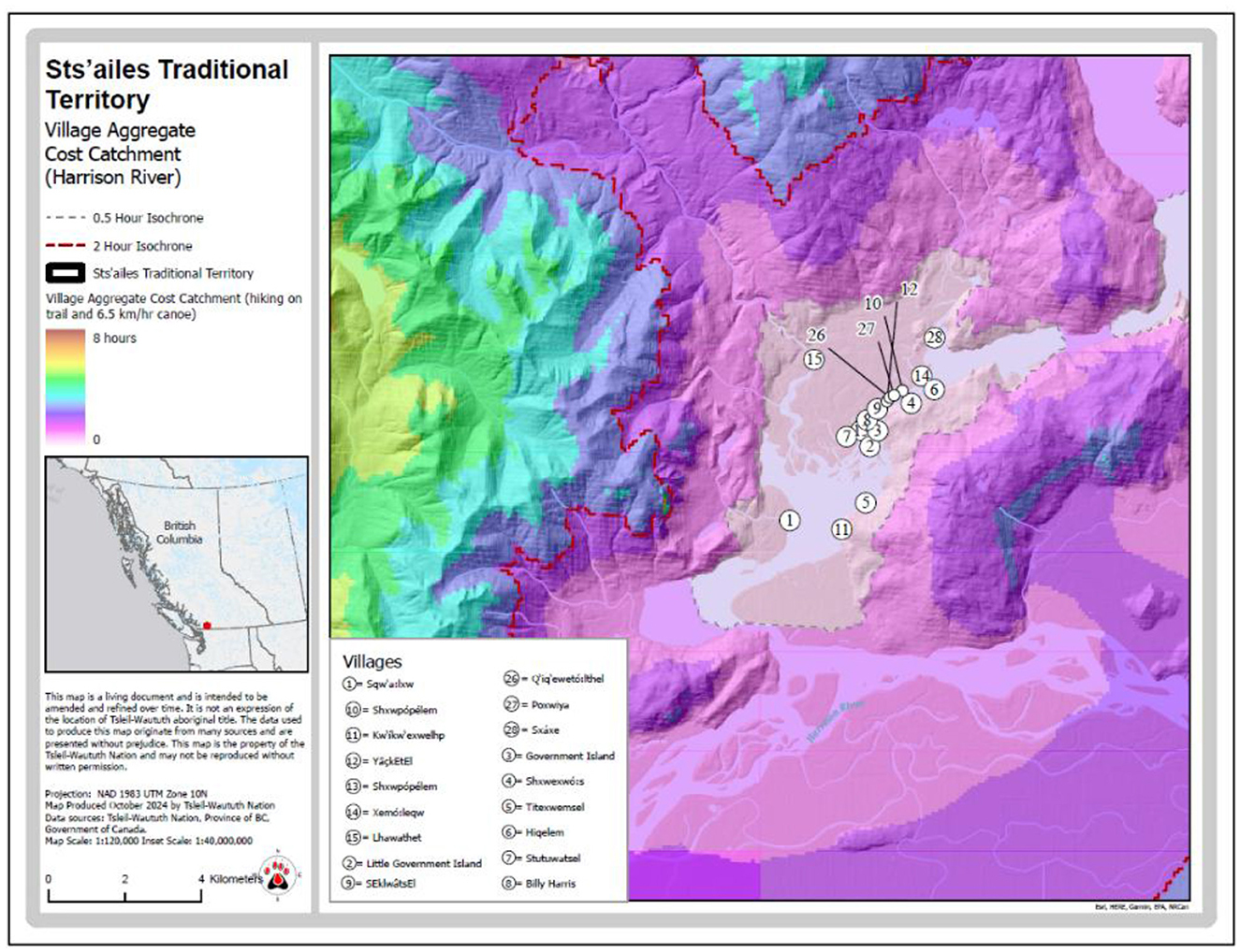
Figure 10. Aggregate cost catchment for modeled pre-contact Sts'ailes villages on the Harrison River.
Discussion
Developing this LCA model of traditional Coast Salish landscape and seascape use provides numerous insights into how territories were defined in relation to waterways, mountains, settlements, and harvesting areas. In the sections below, we briefly highlight observed correspondences between modeled use areas, recorded use areas, and each tribes' respective territories.
First, to further assess the validity of our modeled LCA, we compared the modeled site catchments from the village of sǝłilwǝtał to the recorded traditional use study (TUS) data describing Tsleil-Waututh fishing activities. This TUS data derived from interviews with Tsleil-Waututh people who harvested resources from Burrard Inlet since about 1940 CE (Tsleil-Waututh First Nation, 2000, 2011). Here, Tsleil-Waututh fishing locations (places where people harvested fish within their lifetime) are indicated by shaded polygons representing the density of reported fishing locations. The shorter and longer dashed lines represent the 30 min and 2-h travel isochrone from the village of sǝłilwǝtał as predicted by our LCA model. The 2-h isochrone is the feasible site catchment and the 30 min isochrone is the immediate site catchment.
The similarities between Tsleil-Waututh's TUS on fishing in Figure 11 the LCA model calculated for the village of sǝłilwǝtał are striking. The 30-min isochrone for sǝłilwǝtał is very similar to the area of most dense fishing activities in Burrard Inlet (Figure 11). The only major difference between the two is that Tsleil-Waututh intensively fished on the lower reaches of Seymour Creek, just to the west (perhaps 10 min distant) of the 30 min least cost catchment. The 2-h isochrone for sǝłilwǝtał corresponds broadly to the moderately dense area of Tsleil-Waututh fishing locations, especially up Indian Arm (Figure 11). Indeed, the 30 min isochrone from sǝłilwǝtał captures about 62% of all reported fish harvesting areas reported in the Tsleil-Waututh TUS data, while the 2-h isochrone captures 94% of all reported fishing areas in the Tsleil-Waututh TUS data. The LCA model did not (and could not) predict the intensive fishing on the Capilano River to the west (also facilitated by modern car travel). We argue that the clear correspondence between the modeled landscape/seascape use in the Tsleil-Waututh case and the observed Tsleil-Waututh TUS strongly indicates that the LCA model accurately predicts marine oriented hunter-gather-fisher resource use areas.
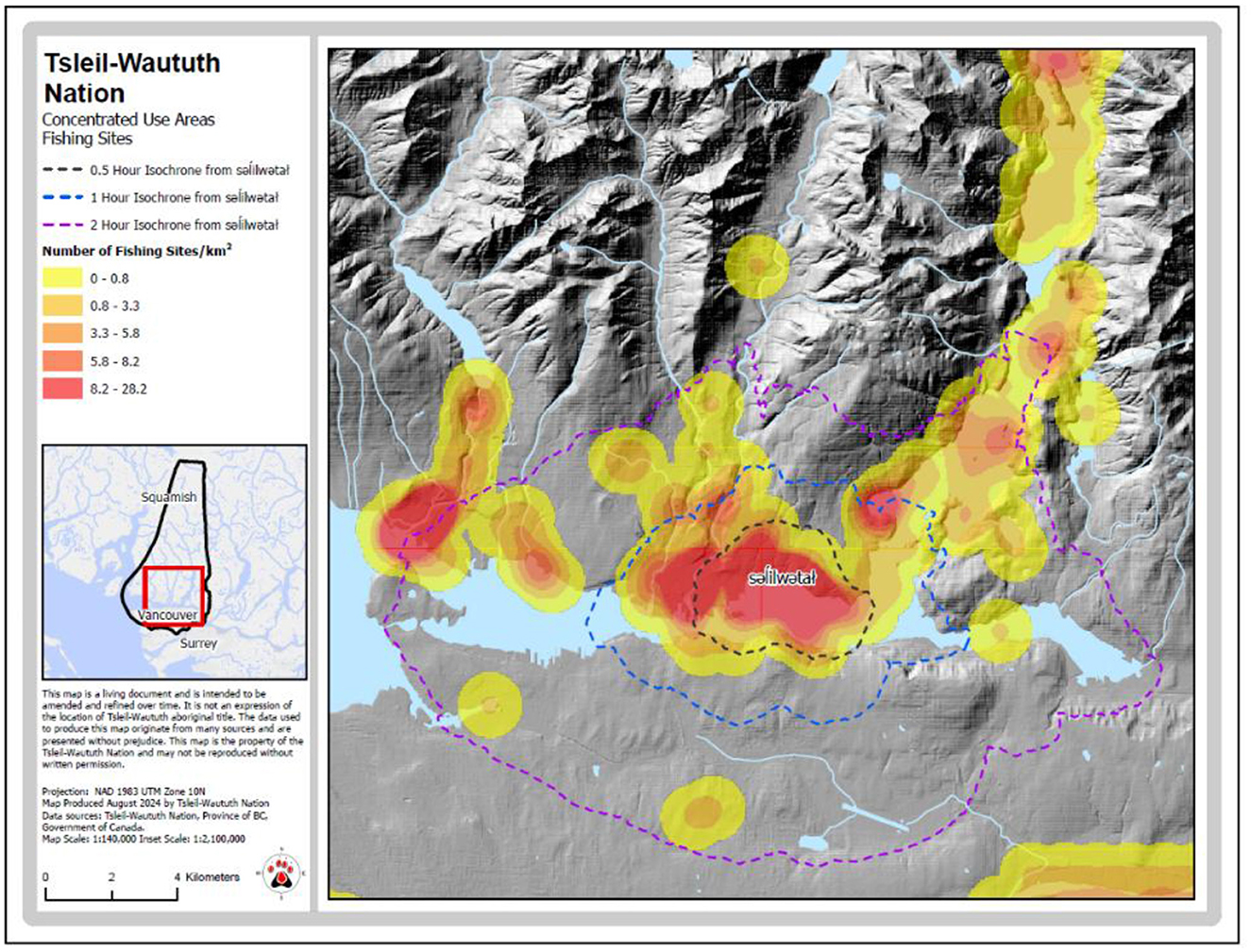
Figure 11. Tsleil-Waututh's TUS data for fishing compared to the LCA modeled use from the village of sǝłilwǝtał.
Further, the large area encompassed by villages' site catchment suggests that villages located in the central area of a watershed could have exploited much of the tribal territory on a daily basis (see also Blake, 2010). If only a few villages were occupied, they still could have accessed the vast majority of the tribal territory, especially the seascape and foreshore, on a daily basis. This means that even if individual villages ceased to be occupied in a particular period, the shape of the tribal catchment area (the aggregate site catchment) would remain quite stable.
With regards to daily foraging areas, this model provides accurate description of the potential catchment areas of individual villages. It is clear that a settlement located on a relatively long stretch of coastline would have a daily catchment area (2-h isochrone) of about 26 km diameter over the water and about 9 km inland, that is 2 h travel by foot or canoe. The shape of these site catchments emphasizes the importance of canoe travel in accessing resources from a relatively broad area, especially of seascape and foreshore.
As noted above, there are several lines of archaeological information that indicate that the areas surrounding these village sites were intensively utilized and managed areas. This includes clear evidence that most resources were harvested from close proximity to village sites (Lepofsky et al., 2007; Morin et al., 2021b), with more remote inland locations being used more infrequently (Toffolo et al., 2019). Areas around village sites were also closely managed, including fish traps and weirs (Arcas, 1999), clam beds and gardens, and likely forest gardens/managed plant communities (Armstrong, 2022). In the case of the Tsleil-Waututh data, perhaps the clearest example of the hyper-abundance of local resources and scarce examples of more distant ones at village sites are the millions of shellfish remains compared to the occasional mountain goat bone (Morin, 2015, p. 195, 210). Thus, both the recorded TUS harvesting activities and archaeological evidence of resource harvesting conform closely to the LCA modeled use areas developed above.
A second notable outcome of this LCA is how closely this aggregate site catchment models conforms to Tsleil-Waututh's description of their traditional territory (Figure 12). To the south, where there are other First Nations villages, the 2-h isochrone approximates Tsleil-Waututh's territorial boundary. To the north, where other First Nations settlements do not occur until the lowlands of the Squamish Valley, the 8-h isochrone approximates Tsleil-Waututh's territorial boundary. Parallels between the aggregate site catchment calculated for Sts'ailes and Sts'ailes territory are also evident (Figure 9). That is to say, to the north and south of the Sts'ailes villages where other Indigenous people had villages, the 2-h isochrone approximates the extent of Sts'ailes territory. To the east and west of the Sts'ailes villages, where other Indigenous villages do not occur until the lowlands of the adjacent watersheds, the 8-houe isochrone approximates Sts'ailes' territorial boundary.
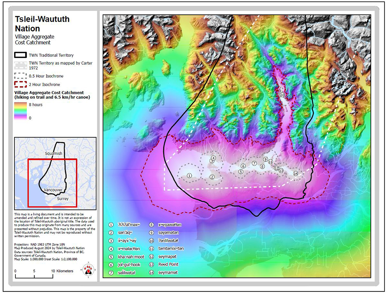
Figure 12. Tsleil-Waututh's aggregate least cost catchment with traditional territory overlain.
We suggest that this correspondence indicates that the extent of Coast Salish tribal territory is largely predicated on the location of a tribe's villages in relation to other tribe's villages, and that the territory is in part defined by the practice of regularly harvesting and managing the resources accessible from each village. The area belonging to the tribe primarily amounts to the sum of the areas used on a near-daily basis by the inhabitants of all the villages belonging to that tribal group. That is to say, Coast Salish tribal territories are defined by the interplay of local geography, technology, and the location of their villages. We suggest that this method should be applied to other Coast Salish and other Northwest Coast First Nations' data to see if this pattern is further corroborated.
Finally, as noted above, territoriality of the kind that we describe has a key role in reinforcing group identity, differentiation, and interaction. In the Tsleil-Waututh and Sts'ailes examples reviewed here, the groups we are speaking of are Coast Salish tribes consisting of multiple villages of related people speaking a distinct dialect, who occupy a defined watershed, and identify themselves as a distinct people. For other Coast Salish peoples this often includes speaking a distinct language (Carlson, 2010; Suttles, 1955). From a Coast Salish perspective, tribes are typically descended from First Ancestors (e.g., Boas, 1894, p. 1; Bouchard and Kennedy, 2002, p. 209; Carlson, 2010; Jenness, 1955; Marshall, 1999, p. 9–17; Wells, 1966, p. 6–12), the first people to arrive at and inhabit a given region, and to which those descendants hold unalienable territorial rights (Gibbs, 1877). The LCA model presented above indicates significant overlap in the utilized area surrounding each village, where people from neighboring villages would likely be interacting with each other on a near-daily basis. This could include harvesting activities, visiting, and social/ceremonial events. This regular and recurrent interaction is what we see as key in the maintenance and reinforcement of tribal group identity.
However, Coast Salish kinship networks are notably exogamous, and they recognize bilateral descent (Kennedy, 2007; Suttles, 1987, 1990; Thom, 2009). This means that all Coast Salish people have an expansive network of kin who reside in or belong to other Coast Salish tribes (Suttles, 1987). These individual kinship connections thus fully transcend tribal affiliation, and has led some researchers to describe Coast Salish territorial boundaries as permeable (Thom, 2009). These permeable boundaries between Coast Salish tribes include a larger recognized social unit—a speech community. Both Tsleil-Waututh and Sts'ailes people are part of the Halkomelem speech community that defines the Central Coast Salish, people who are spatially united by fishing rights to the Fraser River (Suttles, 1990). Although not presented here, LCA modeled travel of ~24 h from the mouth of the Fraser River would closely approximate the extent of the Halkomelem community. Our point here is not to model linguistic communities, but to underscore that there are multiple levels of nested Coast Salish identities, and that those shared identities are reinforced and maintained through social, economic, and ceremonial interactions with one's neighbors.
Conclusion
In this paper, we have developed a LCA model that describes traditional pre-contact Coast Salish travel via land and water. This model highlights the ease of canoe travel relative to travel by foot, can be used to predict travel corridors inland. When we compare different iterations of this model to documented Coast Salish harvesting practices, both TUS data and zooarchaeological remains at settlements, we find clear correspondence between our modeled foraging radii and the highest density of documented harvesting locations, suggesting our 2-h travel radius is an accurate model of past effective foraging ranges. When we compare the aggregate LCA of all of a Coast Salish tribes' villages and depictions of Coast Salish groups' territories we again find clear correspondence between the two, suggesting that the sum of the regularly utilized harvesting areas of these villages is an accurate model of tribal territories.
The results of this modeling indicate that marine oriented hunter-gatherer-fishers with canoe technology could have feasibly exploited a very large daily foraging area from their home villages. These areas of seascape use are much larger than the corresponding of landscape use because of the ease and speed of canoe travel. Such modeling gives some insight into the range of resources that were feasibly accessible by the inhabitants of each village, especially regarding access to foreshore and marine resources. With relatively little modification, we see no reason why this model could not be applied to the whole of the Northwest Coast area or other coastal regions. We suggest that this theoretically grounded modeling of marine oriented hunter-gatherer-fishers provides unique insights into this type of subsistence economy, and sheds light on the differences from terrestrial hunter-gatherers.
Implicit within this modeling of movement and resource use, is the social environment in which people also traveled. As described above, the people traveling these landscape/seascapes would be moving to or past other villages, encountering people from other villages at resource harvesting sites, and undoubtedly visiting and socializing with their neighbors and kin. These regular, informal daily interactions between people were at least as important to the social fabric maintaining tribal group identity than the formal potlatches or ceremonies that capture so much attention. We therefore expect that our modeling of travel and land use, also reflects the relative intensity of local social and interpersonal relationships.
Data availability statement
The raw data supporting the conclusions of this article will be made available by the authors, without undue reservation.
Author contributions
JM: Conceptualization, Writing – review & editing, Methodology, Writing – original draft. MR: Writing – original draft, Writing – review & editing, Investigation. MB: Writing – review & editing, Conceptualization, Writing – original draft. AH: Writing – review & editing, Software, Investigation, Resources, Formal analysis, Validation, Visualization, Methodology.
Funding
The author(s) declare that no financial support was received for the research and/or publication of this article.
Conflict of interest
AH was employed at ESRI Canada.
The remaining authors declare that the research was conducted in the absence of any commercial or financial relationships that could be construed as a potential conflict of interest.
Generative AI statement
The author(s) declare that no Gen AI was used in the creation of this manuscript.
Publisher's note
All claims expressed in this article are solely those of the authors and do not necessarily represent those of their affiliated organizations, or those of the publisher, the editors and the reviewers. Any product that may be evaluated in this article, or claim that may be made by its manufacturer, is not guaranteed or endorsed by the publisher.
Footnotes
1. ^It is not the intent of this research to document First Nations' interests in the lands in these areas. The study was conducted without prejudice to First Nations' treaty negotiations, Aboriginal rights, or Aboriginal title.
2. ^We note that our modern experimental canoe was made of fiberglass, and definitely less heavy than a traditional cedar canoe, requiring less effort by paddlers and thereby increasing the speed of travel. However, despite the reasonable amount experience of our modern paddlers/pullers (save the lead author), traditional Coast Salish people would have had thousands of more hours experience paddling, would have been significantly stronger, with more endurance, and more coordination, and would have been able to move even a heavier canoe faster than perhaps all but the most-expert modern racing teams. We think that this vast experience gap of traditional paddlers/pullers vs. modern paddlers/pullers and the near-certain higher speeds of travel by the former suggest our experimental canoe travel speeds under-estimate traditional travel rates.
3. ^Available evidence indicates that most of these settlements were occupied in the centuries immediately prior to contact, but that others were not (Morin et al., 2018; Williams, 2013).
4. ^Distinctly different from this highly cohesive settlement pattern across most of the Harrison Watershed are the settlements at Chehalis Lake. In contrast to the other settlements within the watershed, it would have taken several hours to reach Chehalis Lake from the settlements at 20 Mile Bay and the Harrison River. Significantly, the ethnographic record describes how relations between the people living at Chehalis Lake and the Harrison River changed from non-existent, to strained, before they finally became close family and friends (Boas, 1894; Hill-Tout, 1904).
References
Aldenderfer, M. (1998). Montane Foragers: Asana and the South Central Andean Archaic. Iowa City: University of Iowa Press. doi: 10.1353/book8866
Ames, K. (2002). “Going by boat: the forager-collector continuum at sea,” in Beyond Foraging and Collecting: Evolutionary Change in Hunter-Gatherer Settlement Systems, eds. B. Fitzhough, and J. Habu (New York, NY: Kluwer Academic), 19–53. doi: 10.1007/978-1-4615-0543-3_2
Arcas (1999). Archaeological Investigations in Squamish Nation Territory. Report prepared for Squamish Nation Chiefs and Council. North Vancouver, BC.
Armstrong, C. (2022). Silm Da'axk (to Revive and Heal Again): Historical Ecology and Ethnobotany in Gitselasu Lahkhyuup. Vancouver, BC: Mitchell Press.
Barnett, H. (1955). The Coast Salish of British Columbia. Eugene, Oregon: University of Oregon Press.
Belovsky, G. (1987). Hunter-gatherer foraging: a linear programming approach. J. Anthropol. Archaeol. 6, 29–76. doi: 10.1016/0278-4165(87)90016-X
Bernick, K. (1983). “A site catchment analysis of the little Qualicum River Site, DiSc 1: a wet site on the east coast of Vancouver Island,” in Archaeological Survey of Canada Paper No.118 (Ottawa: National Museum of Man Mercury Series). doi: 10.2307/j.ctv16pm6
Binford, L. (1980). Willow smoke and dogs tails: hunter-gatherer settlement systems and archaeological site formation. Am. Antiq. 45, 4–20. doi: 10.2307/279653
Binford, L. (2001). Constructing Frames of Reference: An Analytical Method for Archaeological Theory Building Using Hunter-Gatherer and Environmental Data Sets. Berkeley, CA: University of California Press. doi: 10.1525/9780520925069
Blake, M. (2010). “Navegación y definición de territories en la Costa Noroeste de Norteamérica. Un ejemplo Coast Salish (English Version - Water Travel and the Definition of Territories on the Northwest Coast),” in La Excepción y la Norma: las Sociedades Indigenes de la Coast Noroeste de Norteamérica Desde la Arqueologia, ed. A. V. J. Estevez (Barcelona: Treballs d'Etnoarqueologia No. 8, CISC-U.A.B), 84–93.
Boas, F. (1894). “Indian tribes of the lower Fraser River,” in 64th Report of the British Association for the Advancement of Science (London), 1–14.
Bouchard, R., and Kennedy, D. (Ed.) (2002). Indian Myths and Legends from the North Pacific Coast of America: A Translation of Franz Boas' 1895 Edition of Indianische Sagen von der Nord-Pacifishcen Kuste Amerikas. Vancouver, BC: Talon Books.
Burley, D. (1989). Senewlets: Culture History of the Nanaimo Coast Salish and the False Narrows Midden. Royal British Columbia Museum Memoir No. 2. Victoria: Royal British Columbia Museum.
Byrd, B., and Brandy, P. (2023). “By boat or by land – GIS least-cost modeling of indigenous native American transportation choices in the San Francisco Bay Area,” in And In Length of Days Understanding“ (Job 12:12) - Essays on Archaeology in the Eastern Mediterranean and Beyond in Honor of Thomas, eds. E. Levy. E. Ben-Yosef, and I. Jones (New York, NY: Springer), 1553–1557. doi: 10.1007/978-3-031-27330-8_66
Carlson, K. T. (2001). “Expressions of collective identity,” in A Sto:lo Coast Salish Historical Atlas, ed. K. Carlson (Vancouver, BC: Douglas and McIntyre), 24–29.
Carlson, K. T. (2010). The Power of Place, The Problem of Time: Aboriginal Identity and Historical Consciousness in the Cauldron of Colonialism. Toronto, ON: University of Toronto Press.
Castile, G. (Ed.). (1985). The Indians of Puget Sound: The Notebooks of Myron Eells. Seattle, WA: University of Washington Press.
Charlton, A. (1972). “Noons Creek and Belcarra: a preliminary report on excavations near port moody,” in Salvage '71: Reports on Salvage Archaeology Undertaken in British Columbia in 1971, ed. R. L. Carlson (Burnaby: Department of Archaeology, Simon Fraser University Publication No. 1), 131–155.
Charlton, A. (1974). Archaeological Investigations at the Cates Park Site (DhRr 8). Report on file with the Archaeology Branch, Victoria.
Charlton, A. (1980). The Belcarra Park Site. Simon Fraser University Department of Archaeology Publication No. 9, Burnaby
Conolly, J., and Lake, M. (2006). Geographic Information Systems in Archaeology. Cambridge: Cambridge University Press. doi: 10.1017/CBO9780511807459
Cooper, J. (2010). Modelling mobility and exchange in pre-Columbian Cuba: GIS led approaches to identifying pathways and reconstructing journeys from the archaeological record. J. Caribb. Archaeol. 3, 122−138.
Coupland, G. (1991). The point grey site: a marpole spring village component. Can. J. Archaeol. 15, 73–96.
Crease, H. P. P. (1863). Provincial Archives of British Columbia, Map Collection, BCARS CM_A1071, sheet 2.
Croes, D., and Hackenberger, S. (1988). “Hoko river archaeological complex: modeling prehistoric northwest coast economic evolution,” in Research in Economic Anthropology: Prehistoric Economies of the Northwest Coast, Vol. Supplement 3. ed. B. Isaac (London: JAI Press), 19–85.
D'Herbomez, F. (1884). “Letter to reverend father Martinet, August 25, 1884,” in Oblates Among the Coast Salish, 1845-1906, ed. K. Carlson.
Dorricott, L., and Cullon, D. (Eds.) (2012). The Private Journal of Captain G.H. Richards: The Vancouver Island Survey (1860–1862). Vancouver: Ronsdale.
Efford, M., Taft, S., Morin, J., George, M., George, M., Cavers, H., et al. (2023). Archaeology demonstrates sustainable ancestral Coast Salish Salmon stewardship over thousands of years. PLoS ONE 18:e0289797. doi: 10.1371/journal.pone.0289797
Fauvelle, M., and Montenegro, A. (2024). Do stormy seas lead to better boats? Exploring the origins of the southern Californian plank canoe through ocean voyage modeling. J. Island Coast. Archaeol. 1–22. doi: 10.1080/15564894.2024.2311107
Franck, I. (2000). An Archaeological Investigation of the Galene Lakes Area in the Skagit Range of the North Cascade Mountain, Skagit Valley Park, B.C. (Unpublished MA thesis). Department of Archaeology, Simon Fraser University, Burnaby.
Gibbs, G. (1877). Tribes of Western Washington and Northwestern Oregon. Contrib. North Am. Ethnol. 1, 157–361.
Grier, C. (2003). “Dimensions of regional interaction in the prehistoric Gulf of Georgia,” in Emerging from the Mist: Studies in Northwest Coast Culture History, eds. R. G. Matson, G. Coupland, and Q. Mackie (Vancouver: UBC Press), 170–187.
Gustas, R., and Supernant, K. (2017). Least cost path analysis of early maritime movement on the Pacific Northwest Coast. J. Archaeol. Sci. 78, 40–56. doi: 10.1016/j.jas.2016.11.006
Ham, L. (1982). Seasonality, Shell Midden Layers, And Coast Salish Subsistence Activities at the Crescent Beach site, DgRr 1 (Unpublished PhD dissertation). Department of Anthropology and Sociology, University of British Columbia, Vancouver, BC.
Harako, R. (1981). “Cultural ecology of human behavior among mbuti pygmies in the Ituri Forest, Zaire,” in Omnivorous Primates, eds. R. Harding, and G. Teleki (New York, NY: Columbia University Press), 499–555. doi: 10.7312/hard92188-014
Harris, T. (2000). “Session 2 discussion: moving GIS: exploring movement within prehistoric cultural landscapes using GIS,” in Beyond the Map: Archaeology and Spatial Technologies, ed. G. Lock (Amsterdam: IOS Press), 116–123.
Hayman, J. (Ed.). (1989). Robert Brown and the Vancouver Island Exploring Expedition. Vancouver, BC: University of British Columbia Press.
Hill-Tout, C. (1904). Ethnological report of the StsEelis and Sk.aulits Tribes of the Halkomelem Division of the Salish of British Columbia. J. R. Anthropol. Inst. 34, 311–376. doi: 10.2307/2843105
Hill-Tout C. (1905). Report on the ethnology of the Stlatlumh of British Columbia. J. Anthropol. Inst. Great Britain 35, 126–218.
Howey, M. C. L. (2007). Using multi-criteria cost surface analysis to explore past regional landscapes: a case study of ritual activity and social interaction in Michigan, AD 1200–1600. J. Archaeol. Sci. 34, 1830–1846. doi: 10.1016/j.jas.2007.01.002
Jenness, D. (1955). The Faith of a Coast Salish Indian. Victoria: British Columbia Provincial Museum, Department of Education.
Kelly, R. (1983). Hunter-Gatherer mobility strategies. J. Anthropol. Res. 39, 277–306. doi: 10.1086/jar.39.3.3629672
Kelly, R. (1995). The Foraging Spectrum: Diversity in Hunter-Gatherer Lifeways. Washington, DC: Smithsonian Institution.
Kennedy, D. (2007). Quantifying “two sides of a coin”: a statistical examination of the central coast salish social network. B. C. Stud. 153, 3–34. doi: 10.14288/bcs.v0i153.657
Lamb, K. (Ed.). (1984). A Voyage of Discovery to the North Pacific and Around the World 1791-1795, Volume II. London: The Haklyut Society.
Lee, R. (1968). “What hunters do for a living, or, how to make out on scare resources,” in Man the Hunter, eds. R. Lee, and I. DeVore (Chicago, IL: Aldine), 30–48. doi: 10.4324/9780203786567-6
Lee, R. (1969). “!Kung bushman subsistence: an input/output analysis,” in Contributions to Anthropology: Ecological Essays. National Museum of Canada Bulletin 230, ed. D. Damas (Ottawa: National Museum of Canada), 73–94.
Lee, R., and DeVore, I. (Eds.) (1976). Kalahari Hunter-Gatherers: Regional Studies of the !Kung San and their Neighbors. Cambridge: Harvard University Press. doi: 10.4159/harvard.9780674430600
Lenert, M. (2007). Coast Salish Household and Community Organization at Sxwoxwiymelh: An Ancient Sto:lo village in the Upper Fraser Valley, British Columbia (Unpublished PhD dissertation). Department of Anthropology, University of California Los Angeles, Los Angeles, CA.
Lepofsky, D., Blake, M., Brown, D., Morrison, S., Oakes, N., Lyons, N., et al. (2000). The Archaeology of the scowlitz site, Southwest British Columbia. J. Field Archaeol. 27, 391–416. doi: 10.1179/jfa.2000.27.4.391
Lepofsky, D., Trost, T., and Morin, J. (2007). Coast Salish interaction: a view from the inlets. Can. J. Archaeol. 31, 190–223.
Livingood, P. (2012). “No crows made mounds: do cost-distance calculations of travel times improve our understanding of Southern Appalachian polity size?” in Least Cost Analysis of Social Landscapes: Archaeological Case Studies for beginners and Experts Alike, eds. D. White, and S. Surface-Evans (Salt Lake City: University of Utah Press), 174–187.
Lovis, W., Donahue, R. E., and Holman, M. B. (2005). Long-distance logistic mobility as an organizing principle among northern hunter-gatherers: a great lakes middle holocene settlement system Am. Antiq. 70, 669–693. doi: 10.2307/40035869
MacLachlan, M., (ed.). (1998). The Fort Langley Journals 1827–1830. Vancouver: UBC Press. doi: 10.59962/9780774852357
Marshall, D. (1999). Those Who Fell From the Sky: A History of the Cowichan People. Duncan: Cultural and Education Centre, Cowichan Tribes.
Matson, R. G., and Coupland, G. (1995). The Prehistory of the Northwest Coast. San Diego, CA: Academic Press.
McLay, E. (1999). The Diversity of Northwest Coast Shell Middens: Late Pre-Contact Settlement-Subsistence Patterns on Valdes Island, British Columbia (Unpublished MA thesis). Department of Anthropology and Sociology, University of British Columbia, Vancouver.
Mierendorf, R. (1999). Precontact use of Tundra Zones of the Northern Cascades range of Washington and British Columbia. Archaeol. Washington 7, 3–23.
Mierendorf, R., Harry, D., and Sullivan, G. (1998). An Archaeological Site Survey and Evaluation in the Upper Skagit River Valley, Whatcom County, Washington. Washington, DC: National Parks Service, North Cascades National Park Service Complex.
Miller, J. (1999). Lushootseed Culture and the Shamanic Odyssey: An Anchored Radiance. Lincoln: University of Nebraska Press.
Mitchell, D. (1983). “Seasonal villages, village aggregations, and political autonomy on the central northwest coast,” in The Development of Political Organization in Native North America, Vol. 1979. Proceedings of the American Ethnological Society, ed. E. Tooker (Washington, DC: American Ethnological Society), 97–107.
Morgan, C. (2008). Reconstructing prehistoric hunter–gatherer foraging radii: a case study from California's southern Sierra Nevada. J. Archaeol. Sci. 35, 247–258. doi: 10.1016/j.jas.2007.02.025
Morice, F. (1880). “Letter to Reverend Father De L'Hermite, August 11, 1880,” in Oblates Among the Coast Salish, 1845-1906, ed. K. Carlson.
Morin, J. (2014). The Burrard Inlet Radiocarbon Dating Project. Report on file at Tsleil-Waututh Department of Treaty, Lands and Resources. North Vancouver.
Morin, J. (2015). Tsleil-Waututh Nation's History, Culture and Aboriginal Interests in Eastern Burrard Inlet. Prepared for Gowlings, Lafleur, Henderson LLP. Submitted to the National Energy Board. Available online at: https://twnsacredtrust.ca/wp-content/uploads/2015/05/Morin-Expert-Report-PUBLIC-VERSION-sm.pdf
Morin, J., and Hunt, A. (2014). Least Cost Catchments in Burrard Inlet: Modelling Traditional Tsleil-Waututh/Coast Salish Areas of Regular Intensive Resource Use Using GIS. Report on file at Tsleil-Waututh Department of Treaty, Lands and Resources, North Vancouver.
Morin, J., Lepofsky, D., Ritchie, M., Porcic, M., and Edinborough, K. (2018). Assessing continuity in the ancestral territory of the Tsleil-Waututh-Coast Salish, southwest British Columbia, Canada. J. Anthropol. Archaeol. 51, 77–87. doi: 10.1016/j.jaa.2018.04.004
Morin, J., Royle, T. C. A., Zang, H., Speller, C., Alcaide, M., Morin, R., et al. (2021a). Indigenous sex-selective salmon harvesting demonstrates pre-contact marine resource management in Burrard Inlet, British Columbia, Canada. Sci. Rep. 11, 1–13. doi: 10.1038/s41598-021-00154-4
Morin, J., Zhang, H., Royle, T. C. A., Speller, C., Alcaide, M., Morin, R., et al. (2021b). DNA-based species identification of ancient salmonid remains provides new insight into pre-contact Coast Salish salmon fisheries in Burrard Inlet, British Columbia, Canada. J. Archaeol. Sci. Rep. 37:102956. doi: 10.1016/j.jasrep.2021.102956
Newcomb, C. F. (editor). (1923). Menzies' Journal of Vancouver's Voyage, April to October, 1792. Victoria: King's Printer.
Orians, G. H., and Pearson, N. E. (1979). “On the theory of central place foraging,” in Analysis of Ecological Systems, eds. D. J. Horn, G. R. Stairs, and R. D. Mitchell (Columbus: Ohio State University), 155–177.
Peterson, R. E. (2022). Maritime least cost path analysis: archaic travel routes in the Upper Great Lakes. Midcont. J. Archaeol. 47, 105–127. doi: 10.5406/23274271.47.2.01
Richards, C. G. H. (1859–1860). Fraser River and Burrard Inlet. Admiralty Chart. Provincial Archives of British Columbia, Map Division, CM/B186.
Ritchie, M., Lepofsky D, Formosa S., Porcic, M., and Edinborough, K. (2016). Beyond culture history: coast Salish settlement patterning and demography in the Fraser Valley, BC. J. Anthropol. Archaeol. 43, 140–154. doi: 10.1016/j.jaa.2016.06.002
Ritchie, M., and Lepofsky, D. (2020). From local to regional and back again: social transformation in a Coast Salish Settlement, 1500–1000 BP. J. Anthropol. Archaeol. 60, 1–14. doi: 10.1016/j.jaa.2020.101210
Ritchie, P. M. (2010). From Watershed to House: The Cultural Landscapes of the Sts'ailes People (Unpublished MA thesis). Department of Archaeology, Simon Fraser University, Burnaby.
Ritchie, P. M., Ritchie, J., Blake, M., Simons, E., and Lepofsky, D. (2024). Settling the record: 3,000 years of continuity and growth in a Coast Salish settlement constellation. J. Anthropol. Archaeol. 73:101570. doi: 10.1016/j.jaa.2024.101570
Roper, D. (1979). The method and theory of catchment analysis: a review. Adv. Archaeol. Method Theory 2, 119–140.
Sakaguchi, T., Morin, J., and Dickie, R. (2010). Defensibility of large prehistoric sites in the Mid-Fraser region on the Canadian Plateau. J. Archaeol. Sci. 37, 1171–1185. doi: 10.1016/j.jas.2009.12.015
Schaepe, D. (2009). Pre-Colonial Sto:Lo Coast Salish Community Organization: An Archaeological Study (Unpublished PhD dissertation). Department of Anthropology, University of British Columbia, Vancouver.
Shaw, C. (2018). A GIS Approach to Ancestral Wabanaki Canoe Routes and Travel Times (Unpublished MA thesis). Department of Anthropology, University of New Brunswick, Fredrickton.
Slayton, E. (2020). Modeling Amerindian Sea travel in the early colonial Caribbean. DHQ: Digit. Humanit. Q. 14, 1–15.
Smith, M. (1940). The Puyallup-Nisqually. Columbia University Contributions to Anthropology 32. New York, NY: AMS Press. doi: 10.7312/smit94070
Springer, C., and Lepofsky, D. (2019). Conflict and territoriality: an archaeological study of ancestral Northern Coast Salish-Tla'amin Defensiveness in the Salish Sea Region of Southwestern British Columbia. J. Island Coast. Archaeol. 13, 1–25. doi: 10.1080/15564894.2018.1562499
Supernant, K. M., and Cookson, C. (2014). Mapping social cohesion in Prince Rupert Harbour, BC: a social application of GIS to the Archaeology of the Northwest Coast. Can. J. Archaeol. 38, 179–210.
Surface-Evans, S., and White, D. (2012). “An introduction to the least cost analysis of social landscapes,” in Least Cost Analysis of Social Landscapes, eds. D. White, and S. Surface-Evans (Salt Lack City: University of Utah Press), 1–10. doi: 10.1353/book41407
Suttles, W. (1951). Economic Life of the Coast Salish of Hario and Rosario Straits (Unpublished PhD dissertation). Department of Anthropology, University of Washington, Seattle.
Suttles, W. (1955). Katzie Ethnographic Notes. Victoria: Provincial Museum, Department of Education.
Suttles, W. (1968). “Coping with abundance: subsistence in the Northwest Coast,” in Man the Hunter, eds. R. Lee, and I. DeVore (Chicago, IL: Aldine), 55–68.
Suttles, W. (1990). “Central Coast Salish,” in Handbook of the North American Indians, Vol 7., ed. W. Suttles (Washington, DC: Smithsonian Institution), 453–475.
Suttles, W. (1998). “The ethnographic significance of the Fort Langley Journals,” in The Fort Langley Journals: 1827-30, ed. M. MacLachlan (Vancouver: UBC Press), 163–212. doi: 10.59962/9780774852357-009
Tanaka, J. (1980). The San Hunter-Gatherers of the Kalahari: A Study in Ecological Anthropology. Tokyo: University of Tokyo Press.
Thom, B. (2009). The paradox of boundaries in Coast Salish territories. Cult. Geogr. 16, 179–205. doi: 10.1177/1474474008101516
Tindale, N. (1972). “The Pitjandjara,” in Hunter-Gatherers Today, ed. M. G. Bicchieri (New York, NY: Holt, Rinehart and Wintson), 217–268.
Tobler, W. (1993). “Non-isotrophic geographic modeling,” in Three Presentations on Geographic Analysis and Modeling. Technical Report 93-1 (Santa Barbara, CA: National Center for Geographic Information and Analysis, University of California, Santa Barbara).
Toffolo, M., Ritchie, M., Sellers, I., Morin, J., Lyons, N., Caldwell, M., et al. (2019). Combustion features from short-lived intermittent occupation at a 1300-year-old Coast Salish Rock Shelter, British Columbia: the microstratigraphic data. J. Archaeol. Sci. Rep. 23, 646–661. doi: 10.1016/j.jasrep.2018.11.034
Trost, T. (2005). Forgotten Waters: A Zooarchaeological Analysis of the Cove Cliff Site (DhRr-18) Indian Arm, British Columbia (Unpublished M.A. Thesis), Department of Archaeology, Simon Fraser University, Burnaby.
Tsleil-Waututh First Nation (2000). Tsleil-Waututh First Nation Traditional Use Study 1998-2000. North Vancouver, BC: Document prepared for the Ministry of Forests, Aboriginal Affairs Branch.
Tsleil-Waututh First Nation (2011). Tsleil-Waututh First Nation Knowledge and Use Study Report Phase 1: Foreshore and Marine Areas. North Vancouver, BC: Document prepared for the Tsleil-Waututh First Nation.
Tsleil-Waututh First Nation and Alexander Heritage Consulting (2001). Tsleil-Waututh First Nation Eco-Cultural Resource Guide for Burrard Inlet and Indian Arm. North Vancouver, BC: Documented prepared for the Tsleil-Waututh First Nation.
USGC (2013). National Hydrography Dataset. Available online at: https://www.usgs.gov/national-hydrography/national-hydrography-dataset#:~:text=The%20National%20Hydrography%20Dataset%20NHD,coastline%2C%20dams%2C%20and%20streamgages
Vincent, A. (1984). Plant foods in savanna environments: a preliminary report of tubers eaten by the hadza of Northern Tanzania. World Archaeol. 17, 131–147. doi: 10.1080/00438243.1985.9979958
Wagner, H. (1933). Spanish Explorations in the Strait of Juan de Fuca. New York, NY: AMS Press (1971).
Wells, O. (Ed.). (1966). Squamish Legends: By Chief August Jack Khahtsahlano and Dominic Charlie. Vancouver: C. Chamberlain and F.T. Coan.
White, D. (2012). “Prehistoric trail networks of the Western Papaguería: a multifaceted least cost graph theory analysis,” in Least Cost Analysis of Social Landscapes: Archaeological Case Studies for beginners and Experts Alike, eds. D. White, and S. Surface-Evans (Salt Lake City: University of Utah Press), 188–206.
White, D., and Surface-Evans, S. (Eds.) (2012). Least Cost Analysis of Social Landscapes. Salt Lake City: University of Utah Press.
Williams, L. (2013). Revisiting the Locarno Beach Site (DhRt-6), Vancouver, BC. Unpublished MA thesis, Department of Archaeology, Simon Fraser University, Burnaby.
Keywords: Coast Salish, canoe travel, least cost catchment, GIS, modeling
Citation: Morin J, Ritchie M, Blake M and Hunt A (2025) Modeling Coast Salish landscape/seascape use and territory with GIS. Front. Environ. Archaeol. 4:1613245. doi: 10.3389/fearc.2025.1613245
Received: 16 April 2025; Accepted: 11 June 2025;
Published: 07 July 2025.
Edited by:
Farid Rahemtulla, University of Northern British Columbia, CanadaReviewed by:
Silje Evjenth Bentsen, Nordland County Council, NorwayRob M. Rondeau, Langara College, Canada
Copyright © 2025 Morin, Ritchie, Blake and Hunt. This is an open-access article distributed under the terms of the Creative Commons Attribution License (CC BY). The use, distribution or reproduction in other forums is permitted, provided the original author(s) and the copyright owner(s) are credited and that the original publication in this journal is cited, in accordance with accepted academic practice. No use, distribution or reproduction is permitted which does not comply with these terms.
*Correspondence: Jesse Morin, dGhlamRtb3JpbkBnbWFpbC5jb20=