 Jan Johannes Miera
- 1Professur für Ur- und Frühgeschichte, Historisches Seminar, Universität Leipzig, Leipzig, Germany
- 2Abteilung für Ur- und Frühgeschichtliche Archäologie, Historisches Seminar, Universität Münster, Münster, Germany
The paper discusses the potentials and challenges of geoarchaeological research into long-term prehistoric settlement dynamics. As an example, the study employs a dataset of 367 Bronze Age sites from the Weiße Elster river catchment in Central Germany, spanning the area between the Northern German Plain and the Central Uplands. The recorded sites are systematically processed to create a cohesive dataset with a standardized chronology, consistent classification of site types, and clear spatial delineation. A key focus is on analyzing how archaeological, geographical, and culturally intrinsic filters influence the visibility and preservation of Bronze Age sites across time and space. To investigate settlement dynamics, the study uses chronological frequency distributions, site density metrics, spatial relationships between periods, and Site Exploitation Territories (SETs). The results reveal that the basic trends in Bronze Age settlement dynamics can be identified through the dataset. However, there are limitations. Due to culturally intrinsic filters, each period is represented by a distinct combination of settlements, burials, and stray finds. The reason for this is that some periods can only be identified by artifacts made of a certain material, such as pottery or metal. This is also observed in neighboring regions, suggesting broader regional patterns. Site density analyses show that local communities in the Northern German Plain primarily settled along the Weiße Elster River during the Early Bronze Age (2150–1600 BCE) and Middle Bronze Age (1600–1300 BCE). In contrast, sites from the Transitional Period (1300–1150 BCE) show no clear settlement pattern. The Urnfield Period (1150–800 BCE), is marked by a high concentration of sites in the Northern German Plain and increased land use in the Central Uplands. SET analysis aligns with these findings, further highlighting a dominance of loess soils near Early Bronze Age settlements. Site frequencies remain relatively stable between the Early Bronze Age and Transitional Period but surge sharply during the Urnfield Period – a pattern primarily observed in adjacent study areas in the Central Uplands. Notably, both the start of the Middle Bronze Age and the Urnfield Period are characterized by a widespread abandonment of settlements and burial sites from earlier periods.
1 Introduction
In the late 19th and early 20th centuries, several cornerstones were laid for systematic archaeological research into the Bronze Age in Central Germany. Shortly after Virchow (1872) had described the Lusatian culture and Rýzner (1880) the Únětice culture, Montelius (1885, 1898, 1900a,b,c) and Reinecke (1900, 1902a,b) published chronological systems for the Bronze Age in Northern and Southern Germany, thus providing researchers in Central Germany with further points of reference for archaeological dating. In addition, the introduction of archives with local area files (German: Ortsakten) and the passing of heritage protection laws enabled the long-term conservation and overview of prehistoric monuments and finds (Gummel, 1938; Schmidt, 1986; Aichinger and Grasselt, 2010; Heynowski, 2010a). Simultaneously, comprehensive catalogs and inventories of archaeological finds were published, that became important resources for the research (Götze et al., 1909; Jacob, 1911; Amende, 1922, 1928; Auerbach, 1930).
These cornerstones allowed archaeological research in the beginning 20th century to carry out large-scale and diachronic studies on early human-environment relationships in Central Germany. Hennig (1912) published a geoarchaeological dissertation in which he investigated site distribution patterns between the Neolithic and the Middle Ages with special attention to soil types (Strobel, 2009). In the following decades, this research approach was further taken up by Schlüter (1928, 1931, 1952), Schlüter and August (1959), Leipold (1934), and Schwarz (1948), who discussed prehistoric settlement dynamics with regard to the assumed distribution of open land and primeval forests (Jäger, 1973).
These early studies are characterized by the fact that their statements on human-environment interactions and settlement dynamics during the Bronze Age are based on individual observations and subjective impressions resulting from the examination of distribution maps (Miera, 2022). The dissertation by Müller (1980) on the prehistoric and early historical settlement of the Gothaer Land was a significant step forward in this regard: In contrast to his predecessors, he carried out a statistical analysis of the distribution of the sites using selected terrain covariates. In this way, he pioneered the long-term trend toward diachronic studies on a geostatistical basis (Figure 1). Unfortunately, Müller's approach was not taken up in the following decades (Jacob, 1982; Christl, 1989; Simon, 1991; Peschel, 1992; Hilbig, 1993; Bahn, 1996).
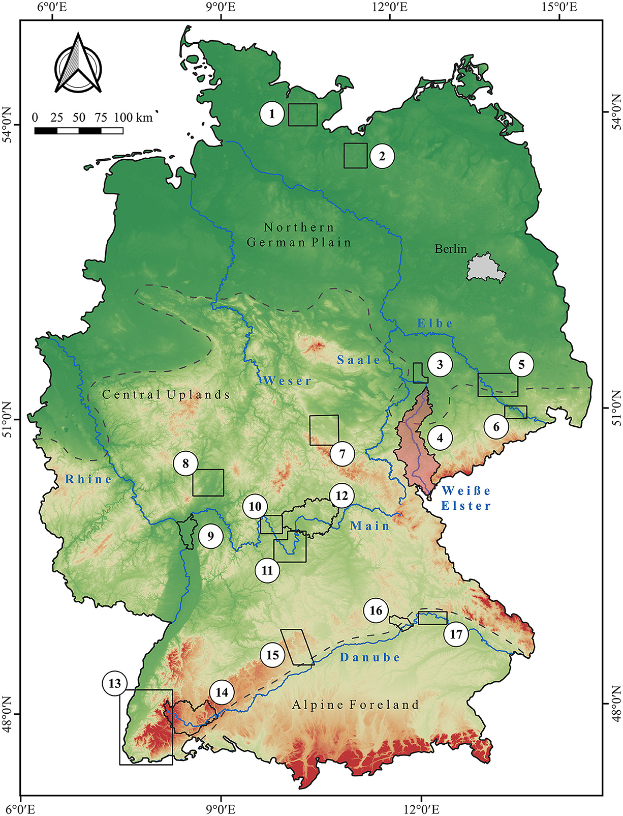
Figure 1. Diachronic studies with a focus on statistical analyses of long-term human-environment interactions between the Neolithic and the Middle Ages in Germany. (1) Holstein lake region (Lüth, 2012), (2) Region between Lake Schwerin and Stepenitz (Schülke, 2011), (3) north-west Saxony (Wegener, 2014), (4) Weiße Elster river catchment (this paper), (5) former district of Riesa-Großenhain (Balfanz, 2003), (6) widening of the Elbe valley at Dresden (de Vries, 2013), (7) Gotha landscape (Müller, 1980), (8) northern Wetterau (Saile, 1998), (9) district of Groß-Gerau (Gebhard, 2007), (10) north-western Main triangle (Obst, 2012), (11) southern Main triangle (Schier, 1990), (12) eastern landscape of Lower Franconia (Pfister, 2011), (13) southern Upper Rhine valley (Mischka, 2007), (14) the Baar and adjacent landscapes (Miera, 2020), (15) Brenz-Kocher valley in the eastern Swabian Jura (Pankau, 2007), (16) lower valley of the Altmühl river (Sorcan, 2011) and (17) Danube valley near Regensburg (Schier, 1985). In addition, the three main landscape units of Germany are shown. Rivers are derived from the European Catchments and Rivers network system (European Environment Agency, 2012). The topography is based on the SRTM 90 m Digital Elevation Database version 4.1 (Farr et al., 2007; Reuter et al., 2007; Jarvis et al., 2008).
It was only after the year 2000 that quantitative evaluations of prehistoric settlement dynamics were carried out again in Central Germany (Balfanz, 2003; de Vries, 2013; Wegener, 2014). However, they used different geographical data, as well as different geostatistical methods and archaeological classifications. Therefore, the current understanding of human-environment interactions and settlement dynamics in Central Germany remains a mix of subjective observations and a limited number of insights based on geostatistical analyses. As a result, their findings can only be compared to a limited extent (Miera, 2022).
This paper builds on the earlier studies mentioned above and addresses existing desiderata. The research background is provided by an interdisciplinary geoarchaeological project that investigates the interplay between the Holocene geomorphological floodplain and slope dynamics, as well as variations in prehistoric and medieval settlement dynamics and climate changes in the loess-covered catchment area of the Weiße Elster (von Suchodoletz et al., 2021, 2024; Ballasus et al., 2022; Grygar, 2022; Miera et al., 2022; Zielhofer, 2022). To this end, a comprehensive database was set up containing more than 3000 archaeological sites from the Paleolithic to the Middle Ages. Here, the Bronze Age sites are presented and discussed in detail for the first time. The aim is not only to provide a supra-regional contextualization of archaeological observations. The paper introduces a toolbox for the investigation of settlement dynamics and the implementation of source-critical analyses that can be applied to other periods and regions. The following objectives are being addressed:
• A presentation of the methodological approach for structuring and processing archaeological and geographical data for a diachronic investigation of prehistoric settlement dynamics
• A source-critical evaluation of the spatial and chronological distribution of sites, considering archaeological, geographical and culturally intrinsic filters
• An analysis of Bronze Age settlement dynamics using site densities, site distribution patterns with respect to selected terrain covariables, site frequencies and spatial affinities of individual periods
• A supra-regional discussion of the results from the Weiße Elster catchment area in the context of observations from adjacent study areas in Central Germany
2 Study area
The study area is located in the tri-border region of the federal states of Saxony, Saxony-Anhalt and Thuringia (Figure 2). Its spatial extent corresponds to the catchment area of the Weiße Elster between Leipzig and the German-Czech border in the Elster Mountains. It covers an area of ~3,026 km2 and lies in the transitional region between two landscapes: the Northern German Plain (German: Norddeutsches Tiefland) and the Central Uplands (German: Deutsches Mittelgebirge) (Ssymank, 1994; Potschin and Bastian, 2004; Schwarzer et al., 2018a,b). The Northern German Plains are characterized by Cenozoic deposits (Kriebel et al., 1998; Radzinski et al., 1999), an average elevation between 100 and 200 m above sea level, gently rolling slopes and fertile chernozem/phaeozem and luvisol soils on loess (Stremme, 1951; Kasch et al., 1953, 1954). The average annual air temperatures is around 10°C and the average annual precipitation is 550–650 mm (DWD Climate Data Center, 2018a,b). The Central Uplands are geologically characterized by Mesozoic and Palaeozoic formations (Emmert et al., 1981). The landscape here reaches an altitude of up to 700 m above sea level. This is accompanied by lower mean annual air temperatures (9–7°C), higher annual precipitation (up to 1,050 mm) and longer winter and frost periods (DWD Climate Data Center, 2018a,b,c,d). The topography of the Central Uplands is also characterized by steep slopes and narrow river valleys. Furthermore, the landscape upstream is less favorable for agricultural use due to low-yielding dystric cambisols and stagnic gleysols (Hartwich et al., 1998; Panagos et al., 2012).
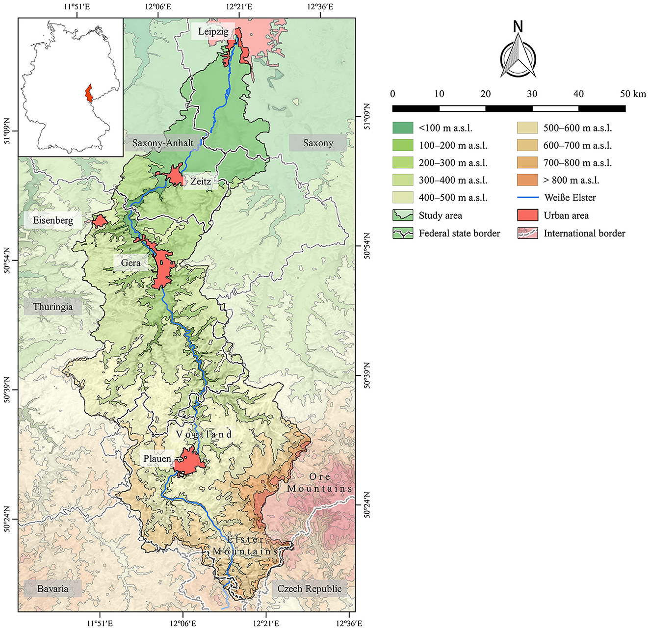
Figure 2. Study area with respect to borders of federal states, international borders, local topography and large urban areas mentioned in the text. The Catchment Characterization Model database (CCM2) was used to extract the research area's contours (Vogt et al., 2007). Political boundaries are drawn according to data from Federal Agency for Cartography and Geodesy [Bundesamt für Karthographie und Geodäsie (BKG), 2024]. The European Catchments and Rivers network system (Ecrins) (European Environment Agency, 2012) and the urban morphological zones dataset are used to determine rivers and urban areas (European Environment Agency, 2007). The SRTM 90 m Digital Elevation Database version 4.1 served as the basis for the topography (Farr et al., 2007; Reuter et al., 2007; Jarvis et al., 2008). Older topographic maps have been used to modify the topography and rivers (Miera et al., 2022).
3 Data and methods
3.1 Collection and processing of archaeological data
An archaeological database was set up for the diachronic analysis of prehistoric and early historical settlement dynamics in this study area. The archaeological archives of the Saxonian Archaeological Heritage Office, the State Office for Preservation of Monuments and Archaeology Saxony-Anhalt and the Thuringian State Office for Heritage Management and Archaeology served as the primary source of information for the database. In addition, the local archaeological literature was reviewed to fill in possible gaps and to consider the latest state of research. Sites without a date, such as potential burial mounds, ramparts and ditches, were only included when their geographical location was known. Sites of unknown date and without a geographical location were not included as their information content is too limited. All in all, between October 2017 and mid-2023, over 3,000 sites were recorded. These include 367 sites dating from the Bronze Age, which are the focus of this paper.
The identification of changes in prehistoric settlement patterns requires archaeological data with the highest possible chronological resolution. For this reason, the dating of the individual sites was recorded at different levels: epoch, period, phase and sub-phase (Eggert, 2012; Eggert and Samida, 2013). Whenever an imprecise dating was provided in the literature or in the archaeological archives, for example a dating between two periods, the respective site was dated to the older period (Schier, 1990). Central Germany presents a unique situation with regard to the dating of Bronze Age sites. Due to its geographical location, the archaeological finds are dated very differently in the literature: Depending on the authors either the chronological system for Northern Germany, Southern Germany or Central Germany is applied. This Babylonian confusion was not included in the database. Instead, all recorded sites were dated according to Paul Reinecke's chronology for Southern Germany. This system has a very high chronological resolution and can be easily translated into the terminology for Central Germany. The implementation of a standardized chronology in the database was a time-consuming step but it enabled the setup of a systematic basis for quantitative analyses and comparisons with data from neighboring regions.
In addition to the chronological resolution of the archaeological data, the quality of their spatial localization and the consistency of their functional classification are important prerequisites for the description and evaluation of settlement dynamics. Against this background, two types of coordinates are differentiated in the archaeological database: Sites with exact coordinates and sites with symbolic coordinates. Exact coordinates were assigned to those sites whose geographical position is known to an accuracy of ± 125 m. Symbolic coordinates, on the other hand, are assigned to all those sites that cannot (or can no longer) be localized in the field due to missing or insufficient geographical information. In these cases, either the presumed location or the church of the nearest village was taken as a point of reference (Ostritz, 2000).
To make the recording and analysis of a large number of sites as efficient as possible, only four types of sites are distinguished: settlements, burial sites, ritual sites and stray finds (Eggert, 2012; Eggert and Samida, 2013). A site is interpreted as a settlement once pits, postholes, building structures, grinding stones, loom weights, spindle whorls or pottery fragments are documented. Human bones and selected artifact ensembles are used as indicators for burial sites. Skeletal remains of humans that are documented in pits within a settlement are registered separately in the database as burial sites. Ritual sites include the deliberate deposition of multiple objects that are not grave, or settlement finds. Stray finds are artifacts and assemblages with little or no contextual information. These finds may be lost objects or material remains from settlements, burials or ritual sites that have (yet) not been identified as such (Schülke, 2011; Obst, 2012).
In geostatistical studies, the spatial definition and extent of archaeological sites is of paramount importance. This definition directly affects the absolute number of sites in any given study area (Pankau, 2004; Schmidt, 2019). For example, frequent construction works or repeated field surveys in a small area can result in the discovery of material remains from large settlements across multiple closely spaced sites. If each of those observations is treated as an independent site, all following (geo-)statics would be considerably distorted, such as the number of sites per period, the density of site distributions, or the importance of terrain covariates for settlement dynamics. Unfortunately, most sites have not been fully excavated, so their original extent remains unknown. As a result, large-scale studies often rely on an artificially defined standard for how sites are spatially grouped and aggregated (Hilbig, 1993; Mischka, 2007; Pankau, 2007). In this study, all sites with exact coordinates were aggregated if they (I) were located less than 250 m apart, (II) were dated in the same or a similar manner (e.g. “Bronze Age” + “Bronze Age”, “Early Bronze Age” + “Bronze Age”, etc.) and (III) were interpreted in either the same or a compatible way (e.g. “settlement” + “settlement”, “burial site” + “single find”, etc.). This approach ensures a basic level of consistency in how archaeological sites are analyzed, while also reflecting the realities of partial excavation and the challenges of interpreting spatial data (Miera et al., 2022).
3.2 Collection and processing of geographical data
For the source-critical analysis of site distributions and the analysis of settlement dynamics, a set of different continuous and categorical grid data was compiled (Supplementary Table 1). For each grid, the cell size was adapted to the spatial resolution of the sites and converted to 250 × 250 m. Some raster data had to be processed before they could be used for archaeological analyses. This applies to the digital elevation model (DEM) of the National Aeronautics and Space Administration (NASA) (Farr et al., 2007; Reuter et al., 2007; Jarvis et al., 2008).
In its original state, this DEM is not suitable for the analysis of site distributions because the terrain in the southern area of Leipzig has undergone considerable changes due to modern open-cast mining (Stäuble et al., 1996; Stäuble, 2010). For this reason, the DEM was corrected based on topographic maps from the early 20th century. Several maps at a scale of 1:25,000 were georeferenced and dozens of contour lines were digitized manually. On this basis, the DEM in the southern area of Leipzig was corrected over an area of 640 km2, i.e., modern disturbances were removed. In addition, old topographic maps were used to correct the courses of local rivers and streams that had been altered in the past 100 years due to the open-cast mining (for a documentation of the local DEM and river modifications see Miera et al., 2022).
It is important to emphasize that the datasets created in this way only represent approximations to prehistoric and early historical conditions as landscapes are subject to constant changes (Gerlach, 2006; Gerlach and Meurers-Balke, 2017). For the processing and analysis of the geographical data, the System for Automated Geoscientific Analyses (SAGA) as well as QGIS and R were used (Conrad et al., 2015; R Core Team, 2020; QGIS Development Team, 2023).
3.3 Archaeological source criticism
In regional studies like this paper, prehistoric and early historical settlement patterns are typically explored by comparing distribution maps across different time periods. These findings are then quantified and analyzed using geostatistical methods and geographic information systems (GIS). To further strengthen the analysis, source-critical approaches are employed to evaluate the representativeness of the archaeological record and the reliability of conclusions drawn from it (cf. Jacob-Friesen, 1928; Eggers, 1959; Gerhard, 2006; Lucas, 2012).
Generally, it can be assumed that the current distribution of archaeological sites is shaped by three types of filters: (I) archaeological filters, i.e., the type and intensity of archaeological fieldwork, (II) geographical filters, such as modern land use and processes of soil redeposition as well as weathering, and (III) culturally intrinsic filters, such as the duration of the archaeological periods under investigation as well as the visibility and identifiability of the archaeological remains from those periods (Pankau, 2007).
The archaeological and geographical filters will be the focus of the following sections. Culturally intrinsic filters, on the other hand, will be addressed in the discussion in the form of a qualitative review of research contributions.
3.4 Archaeological filters
3.4.1 State of research
The current state of archaeological research on the Bronze Age will be summarized using selected key data derived from the database. These include the number of sites per period, their functional interpretation, as well as the accuracy of their coordinates. In addition, it will be analyzed how many of them have been published and what kind of field work has been carried out. Furthermore, the time of discovery of the individual sites is examined. For this purpose, the number of site discoveries is counted for each decade (Schmotz, 1989; Schier, 1990).
3.4.2 Intentionality of site discoveries
There are a variety of activities that can lead to the discovery of archaeological sites. A systematic evaluation of these activities provides an invaluable basis for understanding the temporal and spatial dimensions of archaeological data (Dauber, 1950). In general, a distinction can be made between intentional and non-intentional modes of discoveries (Wilbertz, 1982). The first category includes activities that are archaeologically motivated, i.e., activities aimed at the discovery of material remains or features. For example, this includes excavations as well as field and aerial surveys. In contrast, non-intentional modes of discovery are activities that take place without archaeological motivation such as construction works, the extraction of raw materials, plowing, forestry or hikes. The differentiation between intentional and non-intentional modes of discovery is important insofar as non-intentional data potentially represent a true random sample of the chronological and spatial distribution of the recorded sites (Schier, 1990).
An examination of the intentional modes of discovery sheds light on whether and to what extent site distributions are distorted by field surveys and/or aerial surveys. It has been observed repeatedly that individual people can considerably influence the regional status of archaeological field research. This happens when there is a very strong focus on selected landscapes, types of sites (e.g., burial mounds) or time periods (Mischka, 2007; Pankau, 2007). For this reason, the name of the respective discoverer was recorded during data collection, provided it had been handed down. In general, it can be assumed that individuals can only cause local distortions in the archaeological record once a certain number of discoveries have been made. For this reason, only people who discovered at least nine sites during archaeologically motivated activities are considered in the analysis (Hinz, 2014).
Both the area covered by field surveys as well as the area covered by aerial surveys is calculated and described using the concept of the largest empty circle (Zimmermann and Wendt, 2003; Frank, 2007; Ahlrichs et al., 2016). The areas covered by each method are calculated separately because field surveys and aerial surveys have their own advantages and disadvantages. For example, aerial surveys can result in the discovery of archaeological features on or just below the recent surface that are not (or no longer) recognizable in the field. Field surveys, on the other hand, may result in the discovery of small artifacts on the ground that are not visible from the air (Schier, 1990; Schülke, 2011).
The mapping and evaluation of the surveyed areas is based on isolines representing an average site density of 1.5 and 2.5 km. These threshold values were chosen freely, as there are no standards for the delineation of modeled areas (Mischka, 2007). It should also be noted that only positive detections with an exact localization could be used to determine the potentially walked or flown areas. Negative observations cannot be considered because they are not systematically documented. In this respect, the modeled areas tend to be smaller than the areas actually investigated.
3.5 Geographical filters
3.5.1 Site distribution in relation to archaeological site visibility and preservation of material remains
Archaeological site distributions are not only effected by the intentionality of individual site discoveries, but also by the visibility of the sites themselves. The visibility of archaeological sites and the preservation of material remains are known to be effected by local geomorphic terrain dynamics. Alluviation and colluviation can result in the superimposition of prehistoric sites and thereby protect them from weathering. However, this is taking place at the expense of their visibility. On the other hand, prehistoric sites may be uncovered as a result of erosion, improving accessibility at the expense of worse preservation conditions or even their total destruction because of increased exposure to weathering and plowing.
These geographical filters can be studied on the basis of the site discoveries. Each mode of discovery provides information about the depth of the respective archaeological site. One group consists of (I) sites that are found on the surface. These sites are often long known (i.e. burial mounds, ditches, ramparts, etc.) or are discovered by chance. Furthermore, field surveys result in the discovery of sites on the recent surface. (II) A further group consists of sites buried beneath the modern surface. These are typically discovered during construction works, plowing, forestry, the extraction of raw materials or excavations (Schier, 1990; Saile, 1998). This information can be used to analyze how many Bronze Age sites were recorded on the recent surface and how many of them were buried due to natural or anthropogenic erosion processes. This is crucial for the evaluation of field surveys.
In addition, it is important to discuss the preservation conditions of the material remains themselves. To address this issue, the type of material discovered at each site was recorded. A general distinction was made between pottery and artifacts made of stone or metal as these are the most common material typeson Bronze Age sites. The information derived from the various modes of discovery can be utilized to investigate if the different materials are predominantly associated with buried sites or not. For example, if pottery is mainly found at buried sites this might indicate a disintegration of this material on the surface due to long exposure to weathering.
3.5.2 Site distribution in relation to modern land use
Since the early 20th century, recent land use has repeatedly been identified as a filter whose examination contributes to the understanding of contemporary site distributions (cf. Wahle, 1921; Koschik, 1981; Vogt and Kretschmer, 2019). To investigate the influence of modern land use on Bronze Age site distributions, the grid dataset from the European CORINE (Coordination of Information on the Environment) Land Cover (CLC) project of the European Environment Agency (EEA) is used (European Environment Agency, 2007). This dataset has already been used successfully in several studies for source-critical analyses (Kerrel et al., 1991; Pankau, 2007; Fender, 2017; Sauer, 2018). The dataset is derived from satellite images and distinguishes a total of 44 classes of modern land use with a spatial resolution of 100 × 100 meters (European Environment Agency, 2007). In its original state, the dataset is too complex for archaeological research and statistical analyses due to the large number of land use classes. It is therefore recommended to aggregate it to the following basic types of modern land use: urban areas, forests, arable land, grassland, water bodies, bogs and open-cast mines (Mischka, 2007; Pankau, 2007; Hinz, 2014). Following the aggregation of the land use classes, an additional modification had to be made because not all open-cast mining areas in the southern area of Leipzig were recorded in the raster dataset (cf. Miera et al., 2022).
Here, the chi-squared test is used to analyze the distribution of sites across the land use classes (formula explained by Shennan, 1988; Barceló, 2018). In this method, two observations are related to each other: the frequency distribution of modern land use classes in the study area and the frequency distribution of the sites across the individual land use classes. Only sites with exact coordinates are used for this analysis. If modern land use has no impact on the distribution of the sites, the frequency distribution of the sites across the land use classes should be congruent with their respective occurrence in the study area. Any differences between the observed and expected number sites indicate that the respective type of land use has a positive or negative effect on the preservation and visibility of archaeological sites. Finally, the chi-squared value can be used to determine the extent to which the observed deviations are statistically significant (Mischka, 2007; Pankau, 2007).
3.6 Analysis of settlement dynamics
3.6.1 Site frequency
Bronze Age settlement patterns are analyzed in chronological and spatial terms. One straightforward way to assess local settlement intensity is by calculating site frequency. This metric relates the number of sites recorded during a specific period to the length of that period. To compute the site frequency, the total number of sites dating to a given period is multiplied by 100 and then divided by the duration of the respective period in years. In other words, site frequency represents the average number of sites per century for each period, making it a useful tool for comparing periods with different durations side-by-side (Schmotz, 1989; Paetzold, 1992).
This approach has been widely applied in diachronic studies (Saile, 1998; Schefzik, 2001; Pankau, 2007; Wegener, 2014; Ahlrichs et al., 2018; Miera, 2020). However, it's important to note that the size of a study area directly affects the total number of sites recorded during a period. Larger regions naturally yield higher site frequencies compared to smaller ones. To account for this, the average site frequency per 250 km2 is calculated for all study areas included in a supra-regional contextualization of Bronze Age site frequencies from the Weiße Elster catchment (formula provided in Miera et al., 2022).
Another key step in comparing site frequencies across neighboring regions is aligning the archaeological data to a single chronological framework. Here, the absolute numbers of Bronze Age sites are grouped into the following time windows: Early Bronze Age (2150–1600 BCE), Middle Bronze Age (1600–1300 BCE), Transitional Period (1300–1150 BCE), and Urnfield Period (1150–800 BCE) (Figure 3).
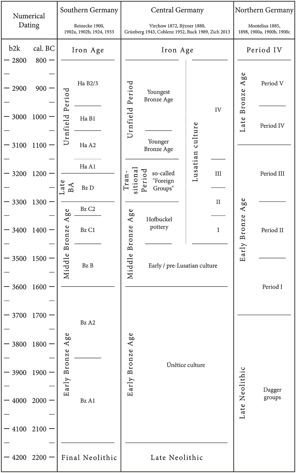
Figure 3. Chronological system for the Bronze Age in Central Germany according to Virchow (1872), Rýzner (1880), Grünberg (1943), Coblenz (1954), Buck (1989), and Zich (2013). The synchronization with the systems of Reinecke (1900, 1902a,b, 1924, 1933) and Montelius (1885, 1898, 1900a,b,c) is based on Puttkammer (2008a,b) and Gramsch (2010).
3.6.2 Site distribution and density
Two methods are combined to describe the spatial distribution of Bronze Age sites. The first is based on point mapping, which distinguishes between sites with exact and symbolic coordinates. In addition, the density of sites with exact coordinates is determined based on the largest empty circle (LEC). To increase the comparability of the period-specific site distributions, the isolines for an average site density of 1.5 and 2.5 km are used. This procedure makes it possible to identify geographical focal points of settlement for each period and thus derive long-term settlement dynamics from the maps (Zimmermann et al., 2005, 2009; Schmidt et al., 2021). The inclusion of sites with a symbolic coordinate is done deliberately. Even archaeological data with a less optimal state of research provide important information on prehistoric settlement dynamics when mapped on a larger scale. This also prevents the potential fallacy that areas without sites were not settled in prehistoric times.
3.6.3 Spatial continuity and affinity of Bronze Age periods
Furthermore, a geostatistical approach is used to examine how different periods overlap in the immediate surroundings of the recorded sites. By doing so, key changes in local settlement patterns and recurring trends can be identified that cannot be detected through site frequencies and differences in site densities (Schier, 1985, 1990; Saile, 1998, 1999; Gebhard, 2007).
The spatial continuity and affinity of Bronze Age periods is examined by creating a 250-meter radius around each site with exact coordinates. Within these defined areas, the chronological frequency distribution of the sites is calculated. The K* coefficient is then used to quantify the observed co-occurrence of different periods. It is calculated in two steps (Saile, 1999):
Where K is the preliminary and non-normalized version of K*, Z is the absolute number of sites dating to one period, S is the absolute number of sites dating to the other period, and B is the absolute number of instances where Z and S occur together.
Where K* is the normalized coefficient, K is the preliminary and non-normalized version of K*, Z is one period, S is the other period.
K* reaches a maximum value of 1 when all sites of one period are spatially associated with another period – for example, if all Middle Bronze Age sites are recorded within the area covered by the 250-meter radii of Early Bronze Age sites. In case of a low spatial affinity, K* tends toward zero (Saile, 1999). To evaluate the impact of different types of archaeological sites on this metric, the analysis is carried out in three ways: (I) based on settlements alone, (II) based on settlements and burial sites, and (III) by considering all sites regardless of their functional interpretation.
3.6.4 Site Exploitation Territories (SETs) and settlement dynamics
It is likely that communities' perceptions and use of their environment evolved over the course of the Bronze Age. This hypothesis can be tested using a geostatistical analysis of how recorded sites were distributed across selected terrain covariates. Here, this is done using the concept of SETs, which differs from traditional point pattern analyses and Site-Catchment Analyses (SCA). Unlike those methods, SETs account for the topographical context of each site (Higgs, 1972, 1975; Jarman et al., 1972, 1982). A SET is an area that could have been exploited economically, defined by the time it takes to travel to and from the site. Accordingly, its shape is heavily influenced by local topography, meaning SETs tend to form circular shapes in flat regions and irregular shapes in low mountainous areas (cf. Bailey and Davidson, 1983; Valde-Nowak, 2002).
Ethnographic observations have provided important clues for the definition of time distances for mobile and sedentary societies. In sedentary societies, the resources necessary for everyday life are in an area that can be reached on foot within an hour. The most important agricultural and economic areas are located directly at the place of residence and can be reached within 10 to 15 min (Vita-Finzi and Higgs, 1970; Higgs and Vita-Finzi, 1972; Jarman, 1972).
Accordingly, the individual SET for a time-distance of 10 min is modeled for each Bronze Age site with an exact coordinate. For this purpose, a freely available script for the programming language R is used (Ahlrichs et al., 2016; Miera et al., 2023). The DEM with a resolution of 250 × 250 meters, an estimated walking speed of 5 km/h in flat terrain (Tobler, 1993) and an attenuation of the walking speed on slopes with an inclination of >15° serve as a working basis. For the description of the site distribution via terrain covariates, two statistics are collected for each period: (I) once for all sites and (II) once exclusively for settlements (Miera et al., 2022).
The following parameters are used to characterize the SETs: the size of the modeled SETs, the altitude above sea level, the slope steepness and the altitude above the nearest water body, the distance to the nearest water body and the proportion of soils on loess within the modeled SETs (Supplementary Table 1). It is important to keep in mind that all these parameters are subject to both natural and anthropogenic changes (Gerlach, 2006; Eckmeier et al., 2011; Gerlach and Meurers-Balke, 2017). SET analyses should therefore be understood as models that represent an approximation to prehistoric conditions and provide a general basis for discussing settlement dynamics.
4 Results
4.1 Archaeological filters
4.1.1 State of research
The archaeological record of Bronze Age settlements in the Weiße Elster catchment area comprises 367 sites. Due to the nature of the archaeological record, only a fraction of the sites can currently be chronologically analyzed at the level of phases or even sub-phase. Therefore, the Bronze Age settlement dynamics in the study area will be investigated at the level of periods.
Out of the 367 sites, 48 date to the Early Bronze Age, 23 to the Middle Bronze Age, 19 to the Transitional Period and 155 to the Urnfield Period. In addition, there are 122 sites that are generally described as “Bronze Age” due to a lack of diagnostic finds. The frequency distribution of the site types across the periods is remarkable. Significantly more settlements than burial sites were recorded from the Early Bronze Age and the Urnfield Period—the same applies to the “Bronze Age” sites without a more precise date. The Middle Bronze Age sites show a balanced relationship between settlements and burial sites. However, this period is mainly documented by stray finds. The Transitional Period is distinguished from the other periods by the fact that the number of recorded settlement sites is only half as high as the number of burial sites (Supplementary Table 2).
In total, 265 of the recorded sites can be precisely localized (Supplementary Table 2). The remaining 107 sites were given a symbolic coordinate. Within the Early and Middle Bronze Age, the number of sites without localization is relatively high. In contrast, the Transitional Period and the Urnfield Period are characterized by a low proportion of symbolic coordinates. This trend can be explained by the fact that stray finds make up a relatively large proportion of the Early and Middle Bronze Age dataset and that these are often old finds with no details of the find location.
The frequency distribution of site discoveries per decade reflects the local development of heritage management as well as political developments in Germany (Supplementary Figure 1). While the decades of the 19th century are characterized by a low frequency of discoveries, an increase marks the beginning of the 20th century. The increasing number of site discoveries between 1901 and 1910 and in the period from 1921 to 1940 goes hand in hand with a systematization of heritage management (Schmidt, 1986; Aichinger and Grasselt, 2010; Heynowski, 2010a; for a critical review of archaeological research between 1933 and 1945 see Härke, 2000; Leube, 2002; Halle, 2013; Grunwald et al., 2016). There is a noticeable decline in discoveries in the decades overlapping with the First and Second World War. This development can be observed across Germany (Pankau, 2007; Schülke, 2011; Miera, 2020). In the 1950s, the number of discoveries returned to pre-war levels and declined again until 1990. Following the reunification of Germany, many construction projects were carried out in the 1990s, the archaeological supervision of which led to a substantial increase in discoveries and excavations (Fröhlich, 1998). Almost a fifth of all Bronze Age sites were discovered in the 1990s. After the turn of the millennium, the frequency of site discoveries declined (Supplementary Figure 1).
An examination of the publication status shows that more than half of the Bronze Age sites had not been published at the time of data collection. These sites were previously only known in the archaeological archives (Supplementary Table 3). The proportion of unpublished sites from the Early Bronze Age and Urnfield Period and in the group of “Bronze Age” sites is comparatively high. The Middle Bronze Age and the Transitional Period take a special position insofar as most sites from these periods have been published. Furthermore, depending on the type of site, the proportion of (un)published sites varies: most settlements and stray finds have not yet been published. This applies in particular to the sites that have been discovered during excavations since the 1990s. In contrast, most burial sites and hoards have been published (Supplementary Table 3).
4.1.2 Intentionality of site discoveries
For a total of 294 Bronze Age sites, it was possible to determine the circumstances that led to their discovery (Supplementary Table 4). The majority can be attributed to non-intentional modes of discovery, in particular construction works and the extraction of raw materials. Only 60 sites from the Bronze Age were discovered during archaeologically motivated activities such as field surveys or excavations. The proportion of non-intentional discoveries predominates in all types of sites.
The chronological frequency distribution of non-intentional discoveries shows that a decline in sites characterizes the transition from the Early to the Middle Bronze Age. In contrast, the absolute proportion of non-intentionally discovered sites from the Transitional Period does not differ from that of the Middle Bronze Age. Finally, the Urnfield Period, on the other hand, is marked by a considerable increase in the number of sites.
In total, 12 individuals have identified nine or more sites each within the study area. Together, they documented 263 prehistoric and early historic sites, which were used to model potential survey areas (Figure 4). This analysis highlights a concentration of successful field work south of Leipzig and within the Zeitz–Eisenberg–Gera triangle. Smaller regions are also present north and south of Plauen in the Vogtland. However, the 12 individuals discovered no more than 15 Bronze Age sites altogether (Supplementary Table 5).
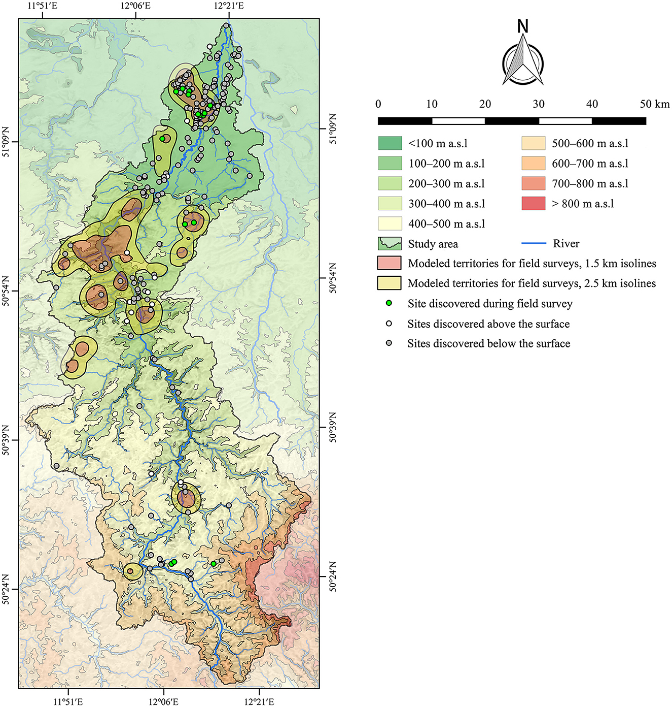
Figure 4. Distribution of Bronze Age sites with respect to their modes of discovery against the background of areas investigated by field surveys and aerial photography. Rivers are plotted according to the European Catchments and Rivers network system (European Environment Agency, 2012). The topography is based on the SRTM 90 m Digital Elevation Database version 4.1 (Farr et al., 2007; Reuter et al., 2007; Jarvis et al., 2008). Topography and rivers are modified according to older topographic maps (Miera et al., 2022). See Figure 2 for the location of the urban areas mentioned in the text.
4.2 Geographical filters
4.2.1 Site distribution in relation to archaeological site visibility and preservation of material remains
Most Bronze Age sites were buried at the time of their discovery. This is true for the individual periods as well (Table 1). Whenever sites were discovered on the surface, this usually happened in the context of archaeologically motivated activities, i.e., there are very few accidental discoveries of Bronze Age sites on the surface. In the case of buried sites, the relationship between intentional and non-intentional types of discoveries is reversed. Here, activities without archaeological motivation account for the largest share.
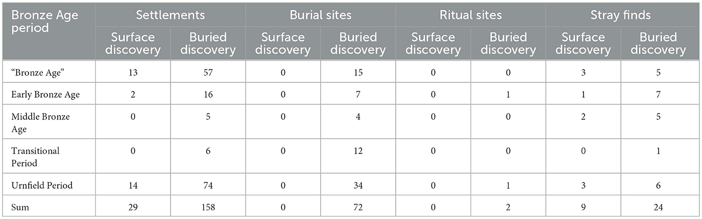
Table 1. Chronological distribution of sites with regard to their depth at the time of their discovery.
There are 257 sites from the Bronze Age where only pottery artifacts have been found (Table 2). In addition, there are 42 sites where stone and metal artifacts were documented alongside pottery. Only stone or metal artifacts are known from 60 sites. The material groups are unevenly distributed across the periods: sites from the Early Bronze Age and the Urnfield Period were identified based on both pottery and metal artifacts. However, in these periods the proportion of sites where only pottery was found predominates. The Middle Bronze Age, on the other hand, is mainly documented by metal finds. The opposite is true for the Transitional Period: this period is known almost exclusively through pottery finds (Table 2).
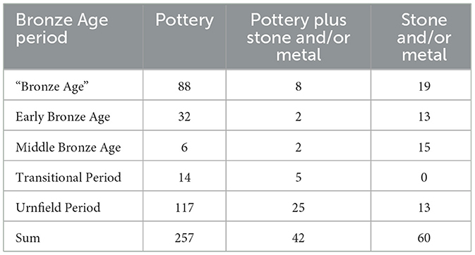
Table 2. Chronological distribution of material groups.
Intentional discoveries are more frequent at surface sites where only pottery was recorded (Table 3). However, most of the sites where only pottery was recorded were buried below the recent surface when they were discovered, and the finds were made by accident. In contrast, the proportion of intentional to accidental discoveries is roughly equal at surface sites where only stone or metal artifacts have been found. This suggests that bronze artifacts are more easily recognized and likely better preserved than pottery.
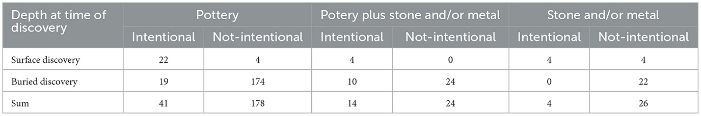
Table 3. Frequency distribution of material groups with regard to the intentionality and depth of their discoveries.
4.2.2 Site distribution in relation to modern land use
The individual land use classes are represented to varying degrees in the study area. Arable land (53.1%) and forest (23.9%) account for the largest shares. Urban areas, open-cast mines and grassland account for 6–9%. Water areas account for only 0.4% of modern land use. Marshes and peatbogs cover only 1 km2 of the study area and thus account for less than 0.1%. For this reason, these latter classes of land use are not considered further in the source-critical analysis.
The Bronze Age sites show an uneven distribution across the modern land use classes (Figure 5). This observation is statistically significant (see Table 4). This result is primarily due to the fact that approximately twice as many sites were recorded in urban areas and in the vicinity of open-cast mines than would have been expected if there had been an even distribution across all land use classes. Wooded areas and areas classified as grassland also contribute to the uneven distribution. Here, the number of documented sites is far below the respective expected value. Arable land and water areas occupy a neutral position, i.e., the deviations between the observed and expected values are minimal.
Figure 5. Modern land use and Bronze Age site distribution in the study area. Distribution of modern land use classes according to CORINE Land Cover data (European Environment Agency, 2007). The spatial extent of the (refilled) open-cast mines has been modified according to older topographic maps (Miera et al., 2022).
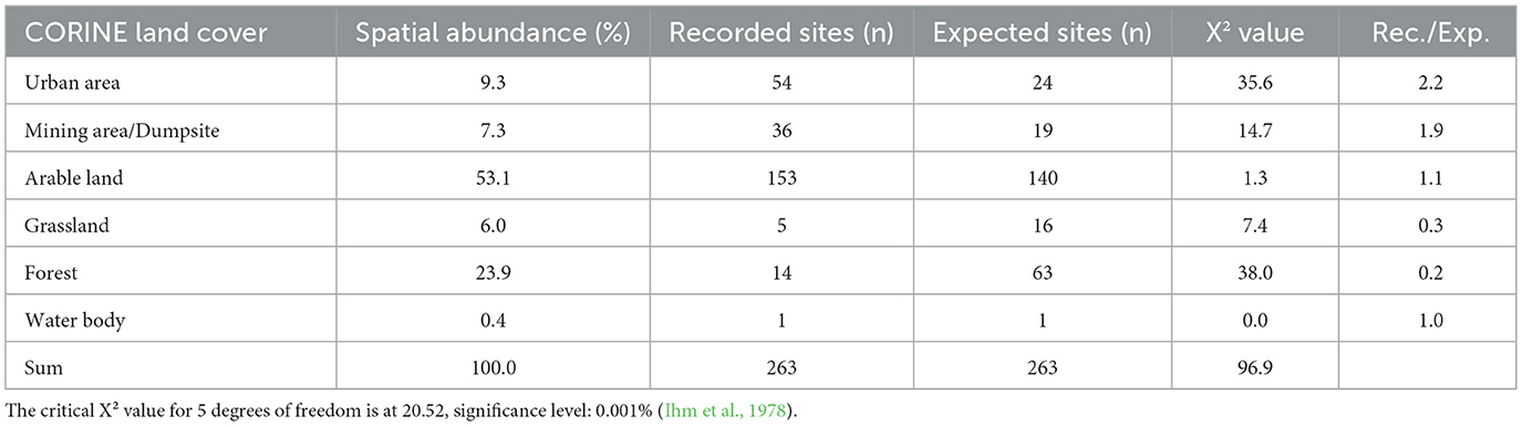
Table 4. Distribution of Bronze Age sites over modern land use.
4.3 Analysis of settlement dynamics
4.3.1 Site frequency
On average, the Bronze Age site frequency is around 28 sites per century. With the transition from the Early to the Middle Bronze Age, a slight decline from nine to eight sites per century can be observed. In the Transitional Period, the frequency of sites rises to 13 before reaching a maximum of 45 sites per century in the Urnfield Period.
4.3.2 Site distribution and density
The distribution of 75% of the Bronze Age sites can be described using the 1.5 km isolines (Figure 6). If the 2.5 km isolines are considered, 89% of the sites are covered with an exact coordinate. Three geographical focal points can be identified: these include a large contiguous area between Leipzig and Zeitz. Here, the sites are primarily located along the Weiße Elster and smaller tributaries. In addition, the 1.5 and 2.5 km isolines describe an increased density of sites near Gera and two smaller areas north and south of Plauen in the Vogtland.
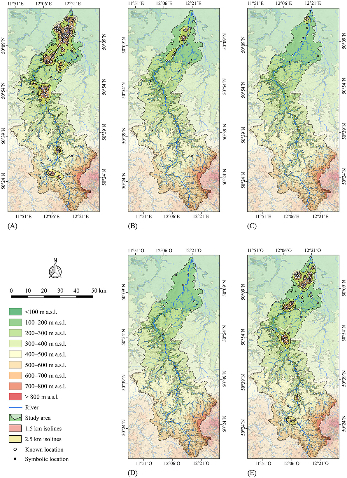
Figure 6. Bronze Age site densities in the study area. (A) Entire Bronze Age, (B) Early Bronze Age, (C) Middle Bronze Age, (D) Transitional Period and (E) Urnfield Period. Rivers are plotted according to the European Catchments and Rivers network system (European Environment Agency, 2012). The topography is based on the SRTM 90 m Digital Elevation Database version 4.1 (Farr et al., 2007; Reuter et al., 2007; Jarvis et al., 2008). Topography and rivers are modified according to older topographic maps (Miera et al., 2022). See Figure 2 for the location of the urban areas mentioned in the text.
A separate analysis of the individual periods shows that the Early Bronze Age sites are concentrated along the Weiße Elster south of Leipzig. Few sites from this period are known from the area of the Central Uplands. In general, this period is characterized by a rather loose scattering of sites: the 1.5 km isoline covers only 30% and the 2.5 km isoline 63% of the sites. The Middle Bronze Age is characterized by a wide scattering of sites. Only in the south of Leipzig a small area with an increased site density is outlined by the 2.5 km isoline. However, only 29% of the sites from this period are in this area. Furthermore, there is a vague correlation to the Weiße Elster valley. In addition, several isolated sites from the Central Uplands are known. The Transitional Period occupies a special position because the sites from this period are so loose and widely scattered that neither isoline can identify a concentration of sites. Compared to previous periods, it can only be noted that the number of sites in the Central Uplands has increased. By contrast, several areas with an increased site density can be identified for the Urnfield Period. The 1.5 km isolines already describe the distribution of 57% of all sites with exact coordinates. The 2.5 km isolines cover 77% of the sites dating to this period. There are remarkable concentrations of sites along the Luppe river, along the Weiße Elster between Zwenkau and Pegau, and in the surroundings of Zeitz and Gera. In the Central Uplands, there are two smaller concentrations of sites near Plauen.
4.3.3 Spatial continuity and affinity of Bronze Age periods
While the Early Bronze Age has a high spatial affinity to the Late Neolithic, a clear break in K* can be observed at the transition to the Middle Bronze Age (Figure 7). There is no spatial affinity between the Early and Middle Bronze Age settlements and burial sites. Even when considering all types of sites, including hoards and stray finds, the spatial affinity between these periods is very low. The opposite is true for the shift from the Middle Bronze Age to the Transitional Period. The few known settlements from these periods show a high affinity. The transition to the Urnfield Period is again characterized by a sharp drop in K*.
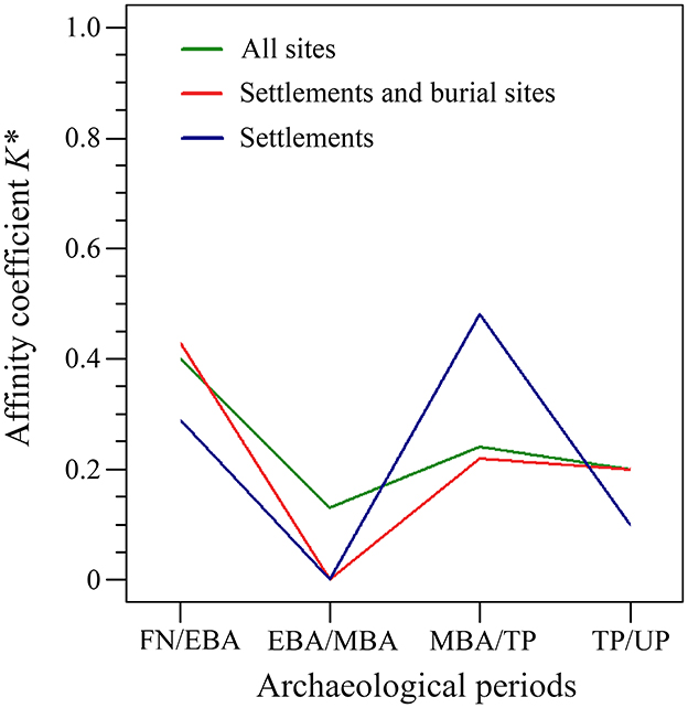
Figure 7. Affinity coefficient K* (Saile, 1999) of prehistoric periods in the Weiße Elster catchment based on all sites (green), the settlement and burial sites (red) and the settlement sites alone (blue). Periods: Final Neolithic (FN), Early Bronze Age (EBA), Middle Bronze Age (MBA), Transitional Period (TP), Urnfield Period (UP).
4.3.4 Site Exploitation Territories (SETs) and settlement dynamics
By investigating terrain covariates based on SETs, the dynamics of Bronze Age land use can be characterized more precisely (Figure 8). The data for the Early Bronze Age, for example, illustrate the focus on the Northern German Plain. This can be recognized by large SETs resulting from the settlement of areas with gentle slopes and low terrain elevation. The distribution of the Early Bronze Age sites is also characterized by a low altitude above the nearest river, combined with rather long distances to the nearest river. Within the Early Bronze Age SETs, soils on loess predominate. This tendency becomes even more apparent in a separate analysis of the settlements.
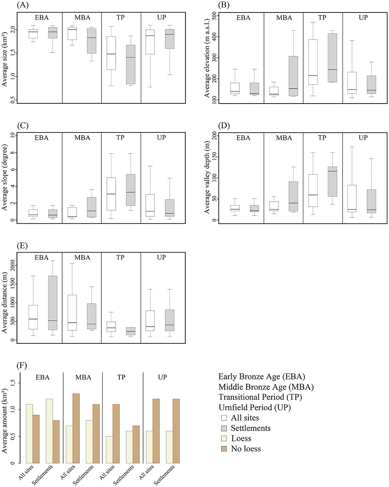
Figure 8. Analyses of Site Exploitation Territories. (A) Size of modeled SETs, (B) terrain elevation, (C) slope, (D) valley depth, (E) river distance and (F) soils on loess and soils not on loess. For more information on each terrain covariate see Supplementary Table 1.
At first sight, the distribution of the Middle Bronze Age sites hardly differs from that of the Early Bronze Age. However, stronger contrasts become visible when looking at the settlements separately. Here there is a tendency toward smaller SETs, due to the more frequent occurrence in areas with steeper slopes. As a result of increased settlement activity in the Central Uplands, there is a higher location above the nearest river and a shorter distance to it. Soils on loess no longer predominate the vicinity of the sites.
The distribution of sites from the Transitional Period differs considerably from the preceding periods and the subsequent Urnfield Period. One of the characteristics is an increase in the average height of the terrain within the SETs. The average size of the SETs decreases as a result due to a focus on areas with more pronounced slopes. There is a noticeable reduction in the distance to the nearest river, while the height above the nearest valley increases. These tendencies become more apparent in the settlement SETs from the Transitional Period. While the average proportion of soils on loess within the SETs is low, the immediate surroundings of the settlements from the Transitional Period are characterized by a balanced proportion of soils on loess.
Sites from the Urnfield Period are primarily observed in areas with a lower slope gradient in the Northern German Plain and therefore show a tendency toward larger SETs. Compared to the Transitional Period, the distance to the nearest river increases, while the height above the nearest river valley is reduced. The average proportion of soil on loess in the vicinity of the sites is comparatively low.
5 Discussion
5.1 Spatial and chronological representativeness of the Bronze Age record
5.1.1 Site distribution with respect to modern land use and archaeological surveys
Modern land use classes are not tied to archaeological criteria. Therefore, they represent an independent sample in terms of the spatial and temporal distribution of archaeological sites (Hinz, 2014; Miera et al., 2022).
This study shows that Bronze Age sites are more likely to be found in urban areas, open-cast mines, and agricultural land. These land use classes are more likely to reveal buried sites as they are associated with construction, farming, or mining. As a result, these land use types can be considered positive filters—they make it easier to find archaeological sites. In contrast, forests, grasslands, and water bodies are more likely to act as negative filters. These environments tend to hide or obscure archaeological evidence, making it harder to detect sites. Similar patterns have been observed in other parts of Germany (Mischka, 2007; Pankau, 2007; Hinz, 2014; Miera, 2020).
The negative filters are mainly found in the Central Uplands. However, they cover less than 30% of the study area, while the positive filters account for 70%. This suggests that the conditions for discovering buried sites are good, even in the Central Uplands. Therefore, the distribution of Bronze Age sites is only partially biased by modern land use, and general conclusions about settlement patterns can still be drawn from distribution maps.
In addition, a biased site distribution due to field surveys and aerial photography can be ruled out. Together, both methods led to the discovery of only 16 Bronze Age sites. Remarkably, a total of 139 Bronze Age sites with exact coordinates were recorded within the modeled territories for field surveys and aerial photography. These sites were mainly discovered during activities that involved some form of opening the surface.
5.1.2 Site distribution with respect to archaeological site visibility and preservation of material remains
Settlement archaeology faces unique challenges in landscapes like the Central Uplands, where pottery preservation tends to be worse than in lowland areas (Miera et al., 2019, 2022). For instance, early interpretations of the sparse site density in the Vogtland attributed this to the disintegration of fragile material due to local soil conditions (Reinecke, 1956). However, this explanation was disputed after Bronze Age pottery from the Vogtland proved remarkably well-preserved (Coblenz, 1954; Simon, 1989, 1991). Moreover, no clear spatial pattern separates areas with and without pottery in the study area—contrary to what is observed in the Neolithic dataset from the Weiße Elster catchment, where a distinct north-south divide exists between pottery-rich sites in the Northern German Plains and pottery-poor regions in the south (Miera et al., 2022). With this in mind, the low site density recorded for the Bronze Age in the Central Uplands likely reflects genuine settlement patterns rather than preservation biases.
However, there is a correlation between the frequency of sites with pottery on the surface and the intentionality of the discoveries: The few pottery finds that have been discovered on the surface are primarily linked to intentional modes of discovery (Table 3). This could be the result of different factors: among other things, pottery is less well preserved on the surface as it is constantly exposed to the elements and therefore becomes fragmented more rapidly than artifacts made of stone or metal (Geilmann and Spang, 1958; Skibo et al., 1989; Madsen, 1991; Sease, 1994; Fuente, 2008; Odegaard and Watkinson, 2023). As a result, pottery finds from the surface are difficult to identify and therefore primarily discovered by trained archaeologists during field surveys. Radig (1934a), for example, had already stated with a certain amount of ridicule that pottery from Bronze Age settlements was poorly researched and “rather unattractive anyway”. Even in recent times, it has been repeatedly pointed out that the state of research into Bronze Age settlement pottery is still insufficient, as finds are often coarse, poorly fired, and heavily fragmented (Möbes and Speitel, 1984; Coblenz, 1969, 1986b; Ebner, 2001, 2005; Bartelt, 2004; Ganslmeier, 2011). One is inclined to agree with Coblenz's (1950) observation that “most finds are discovered by amateurs, and vessel-rich graves attract far more attention than inconspicuous settlement sherds”.
5.1.3 Culturally intrinsic filters: Bronze Age chronologies in Central Germany
The recorded sites are unevenly distributed over the individual Bronze Age periods. These fluctuations are not exclusively the result of long-term changes within the prehistoric communities. A bias due to culturally intrinsic filters must also be taken into consideration—including our current state of knowledge on the chronological framework of Bronze Age periods in Central Germany.
Even after more than a century and a half of research, the chronology of the Bronze Age in Central Germany still faces significant challenges. To date, no regional chronological system has been developed that covers the entire Bronze Age while simultaneously accounting for local characteristics in Saxony-Anhalt, Saxony, and eastern Thuringia. The closest approximation to this goal has been achieved for the Early Bronze Age, when the Únětice culture is clearly identifiable on a supra-regional scale (Zich, 1996, 2013; Becker et al., 2015; Hubensack, 2018a; Schwarz, 2021; for recent revisions see Stockhammer et al., 2015; Brunner et al., 2020).
Dating the Middle Bronze Age has proven to be particularly complex. Early interpretations suggested a smooth transition from the Únětice culture to the Lusatian culture (Richthofen, 1926; Petsch, 1940), but later work by Grünberg (1943) and Coblenz (1952, 1961a, 1969, 1971, 1987, 1990, 1991) revised this view. Their research demonstrated that the classic Lusatian culture was preceded by a Pre-Lusatian culture, a Hofbuckel pottery phase and the Transitional Period (Figure 3). In addition, west of the Weiße Elster, the Middle Bronze Age is represented by the Tumuli culture. Due to a lack of clear evidence for regional developments in Thuringia, these sites are dated using the chronology developed for Southern Germany (Feustel, 1958a,b, 1972; Kaufmann, 1959, 1992; Neumann, 1968; Fröhlich, 1983).
The absolute dating of the Pre-Lusatian culture, the Hofbuckel pottery phase, and the Transitional Period as well as their synchronization with chronologies from Northern and Southern Germany remain active areas of research (Bahn, 1996; Wagner, 2001; Puttkammer, 2008a,b; Gramsch, 2010; Innerhofer, 2010; Schmalfuß et al., 2022). Additionally, the transition between the Middle Bronze Age and the Urnfield Period presents another layer of complexity for those who apply the chronological framework from Southern Germany. Here, the placement of Bz D—whether as part of the late Middle Bronze Age or the early Urnfield Period—remains contested (Neumann, 1958a, 1968; von Brunn, 1959; Billig, 1968; Donat, 1969; Peschel, 1969, 1978, 1987; Schmidt, 1978; Fröhlich, 1983; Lappe, 1986a,b; Speitel, 1986, 1990).
The situation gets even more complex between 1200 and 800 BCE. Three chronology systems are used simultaneously for this time window in Central Germany. This is due to the fact that several cultural areas meet in this region at that time: Influences from the Nordic Bronze Age, the southern German Bronze Age and the Lusatian culture from eastern Central Europe (Engel, 1933; Agde, 1935, 1939; Schulz, 1939; Mildenberger, 1959). Moreover, there are influences from the Bohemian Knovíz culture in the Vogtland (Coblenz, 1954, 1961b, 1963, 1966; Bouzek, 1967; Bouzek et al., 1966). As icing on the cake, hoard finds and burial customs have shown that there is not only a clash of different chronological systems, but also the formation of regional groups (von Brunn, 1954a,b, 1958, 1960; Billig, 1968; Schmidt, 1967, 1972a,b; Wagner, 1983; Lappe, 1986b; Horst, 1972, 1987, 1989; Schunke, 2004). As a result, the chronology and synchronization of the diverse cultural phenomena from the Urnfield Period in Central Germany are under constant revision (Wagner, 1992, 2004; Heynowski, 2010b; Schmalfuß, 2019).
Due to these ongoing revisions and discussions, a pragmatic approach is needed when comparing site frequencies across different regions in Central Germany, as this analysis requires a standardized chronological framework. For this paper, an absolute chronology was adopted that aligns with the synchronization of Southern, Central, and Northern German chronologies, as outlined by Puttkammer (2008a,b) and Gramsch (2010) (Figure 3). Naturally, a different synchronization of the chronological terminologies may result in different site frequencies. Against this background, the observed site frequencies reflect the outcomes of a model calculation designed to highlight key trends.
5.1.4 Culturally intrinsic filters: material visibility of Bronze Age periods in Central Germany
The archaeological record from the Weiße Elster catchment is characterized by an uneven distribution of Bronze Age sites over time, with certain materials—like pottery or stone and bronze artifacts—dominating finds during specific periods. The balance between settlements, burials, and stray finds, also shifts across periods. These findings indicate that the archaeological record is probably influenced by culturally intrinsic filters. Here, these filters are addressed via the chronological frequency distribution of the material groups and the chronological frequency distribution of the different types of sites.
A bias in the Early Bronze Age dataset caused by material-specific preservation conditions is unlikely, as more than half of all sites from this period have been identified through pottery. This well-preserved pottery serves as a critical resource for dating and classifying the Únětice culture (Neumann, 1929, 1958b; Billig, 1958; Zich, 1996; Schwarz, 2021). Altogether, settlements dominate the distribution of site types, with significantly fewer examples of other site categories (Supplementary Table 2). Notably, most burial sites consist of single burials or small groups of graves, and just under half contain grave goods (Voigt, 1972; Sattler, 2015; Hubensack, 2018a). As a result, these burial sites are often discovered accidentally during construction work, leading to their underrepresentation in the archaeological record. This phenomenon is documented in adjacent study areas as well (Balfanz, 2003; Wegener, 2014; de Vries, 2013). Furthermore, until the 1990s, the entire Early Bronze Age settlement system was a desideratum of Central German research (Voigt, 1972; Peschel, 1994; Walter, 1994; Bartelheim, 1996; Wagner, 2001). Only in the last two and a half decades has the state of research been improved by large-scale projects (Stäuble, 1997, 2019; Huth and Stäuble, 1998; Stäuble and Campen, 1998; Walter et al., 2008; Schunke, 2009; Hansen, 2019; Jurkènas and Spatzier, 2019; Schunke and Stäuble, 2019; Risch et al., 2022). It is important to bear this in mind, as this paper compares archaeological data from studies carried out at different times.
Both settlements and burial sites are underrepresented in the Middle Bronze Age dataset—most sites are stray finds. Notably, metal artifacts are present at three-quarters of all Middle Bronze Age sites, with only a quarter identified based on pottery alone. This reflects a state of research that has long been recognized as inadequate (Feustel, 1972; Fröhlich, 1983; Walter, 1994; Bahn, 1996; Tellenbach, 1996). For example, little is known about the settlement pottery associated with the Tumuli culture and the Pre-Lusatian culture, which means both cultures are primarily documented through bronze artifacts. These objects mostly originate from graves or appear as stray finds (Feustel, 1958a, 1993; Coblenz, 1961a, 1969; Gedl, 1977, 1992; Innerhofer, 2010; Ganslmeier, 2011). The few known settlements from this period have largely been discovered through the dating of pits (Spazier, 2011; Schmalfuß et al., 2018a, 2020). The discovery of building structures and wells at Roitzschjora is therefore particularly rare—a finding made possible by the close monitoring of open-cast mining (Schmalfuß and Tolksdorf, 2016). With regard to the excavations of burial mounds near Rittersrain, Feustel (1993) suggested that settlements from the Middle Bronze Age consisted probably of only one or two households and were therefore very small. Accordingly, the fragmented evidence of Middle Bronze Age settlements likely results from a limited archaeological visibility (Jacob, 1982; Fröhlich, 1983; Bahn, 1996; Wagner, 2001; Balfanz, 2003; Innerhofer, 2010).
Much like the Middle Bronze Age the Transitional Period barely visible in the archaeological record (Feustel, 1958a,b; Kaufmann, 1963; Peschel, 1969, 1978). Within the catchment of the Weiße Elster, this period is mainly documented through pottery finds from burial sites that are dated to Bz D based on parallels with the Knovíz culture from Bohemia or the southern German Urnfield culture (Coblenz, 1954; Peschel, 1969, 1978). This can be attributed to the fact that little is known about the settlement system and the settlement pottery from the Transitional Period (Wirtz, 2000; Ebner, 2001; Hellmund, 2012; Schöneburg, 2012; Schöneburg and Linsener, 2014; Lehmann, 2016; Neubeck, 2017). Consequently, the widespread lack of sites dating to the Transitional Period likely reflects the state of research and not the result of prehistoric settlement processes.
The Urnfield Period is characterized by conditions similar to the Early Bronze Age. The number of settlements exceeds the total number of known burial sites by a factor of two, while pottery is the most common type of material. The dataset is affected by culturally intrinsic filters in that the burial sites are primarily shallow burial fields (Barthel, 1972; Buck, 1972; Schmidt, 1972a,b; Lappe, 1986a). Despite the high number of settlements, little is known about the settlement structures themselves. It is only through the systematic monitoring of construction works along routes and open-cast mines in the last two decades that evidence of settlement areas with building structures has become increasingly more frequent (Schwarzländer, 1996; Bartelt, 2004; Koch and Strobel, 2009; Küßner, 2011; Petzold, 2011; Frehse et al., 2012; Wegener and Strobel, 2012; Conrad et al., 2014; Conrad S. et al., 2016; Conrad M. et al., 2016; Schmalfuß, 2014; Homann and Hubensack, 2016; Hubensack, 2018b; Schmalfuß et al., 2018b; Schöneburg and Ender, 2018; Schöneburg et al., 2020). One reason for the frequent lack of building structures may be that these are generally small and, in addition to post structures, log or sill beam constructions were used, which are difficult to detect in the archaeological record (Coblenz, 1969, 1986b; Möbes and Speitel, 1984; Lindinger, 2010; Knoll, 2018). A further challenge lies in the fact that these are mostly small open settlements, and it was also suggested that the settlements often had to be relocated to compensate for the depletion of agricultural land (Coblenz, 1986b; Heynowski, 2010b).
5.2 Bronze Age land use and settlement dynamics in Central Germany
5.2.1 Site frequencies and spatial affinity of Bronze Age periods
There is a total of nine studies from Central Germany that can be used to contextualize the observations from the Weiße Elster catchment (Figure 9). Minor limitations must be accepted insofar that the Bz D phase is combined with the Ha A and Ha B phases in the archaeological catalogs for the Gothaer Land and the northwest Saxony region (Müller, 1980; Wegener, 2014). Consequently, in this case, it is impossible to determine how many sites date to the Transitional Period.
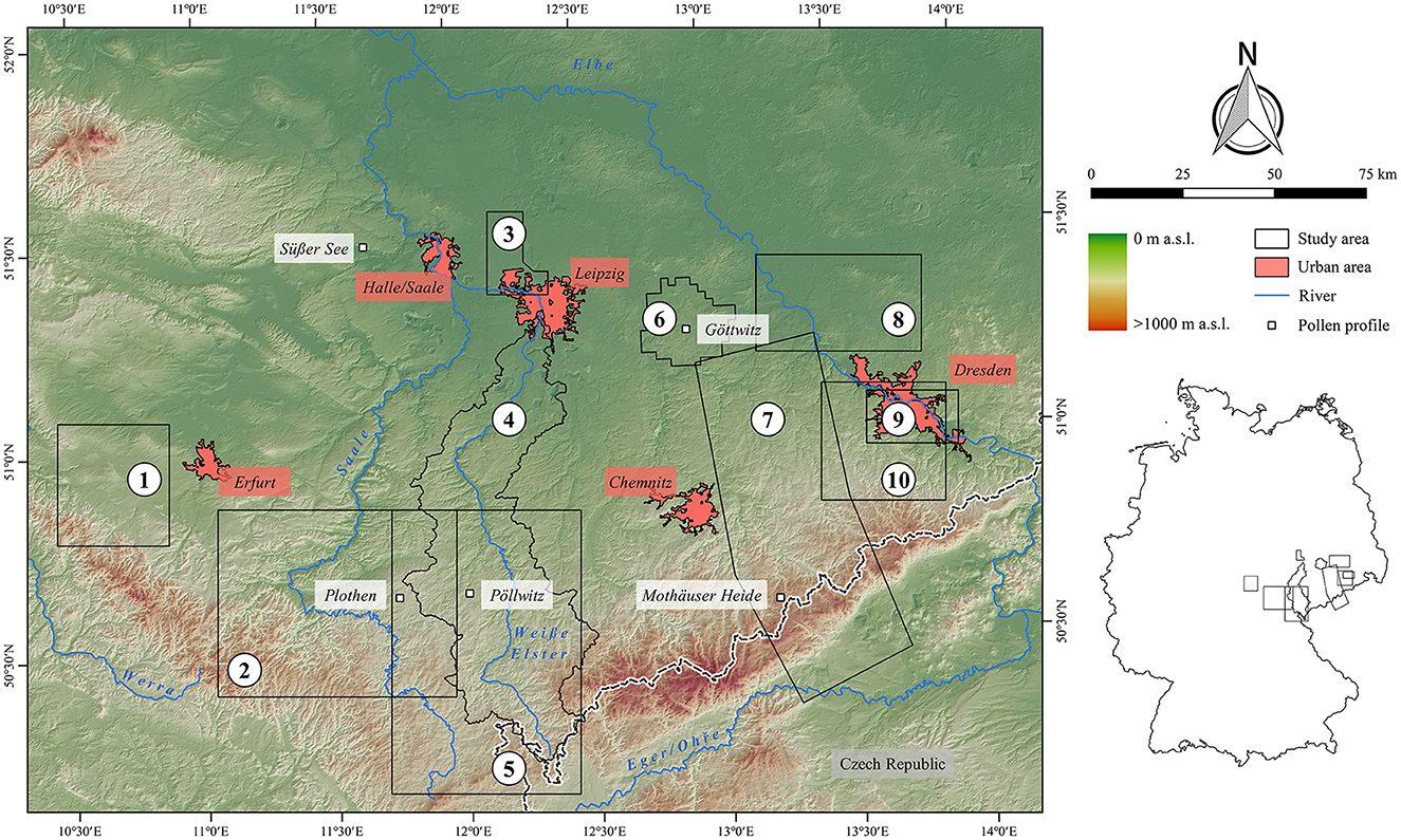
Figure 9. Pollen profiles and study areas from Central Germany mentioned in the text: (1) Gothaer Land (Müller, 1980), (2) Orlagau (Kaufmann, 1959), (3) Northwest Saxony (Wegener, 2014), (4) Weiße Elster (this paper), (5) Vogtland (Simon, 1989, 1991), (6) Lake Göttwitz (Hilbig, 1993), (7) Ore Mountains (Christl, 2004), (8) former district Riesa-Großenhain (Balfanz, 2003), (9) widening of the Elbe valley at Dresden (de Vries, 2013), (10) widening of the Elbe valley at Dresden and eastern Ore Mountains (Jacob, 1982).
Basically, the supra-regional comparison shows that in most of the study areas a stagnation or a slight decline in site frequencies characterizes the transition to the Middle Bronze Age (Table 5). Among the few exceptions are the Orlagau, northwest Saxony and Lake Göttwitz, where the site frequency increased slightly. In the Transitional Period, the frequency of sites increases in almost all regions, except the Elbe valley near Dresden and the Orlagau. A general increase in the site frequency is characteristic of the Urnfield Period. Only at Lake Göttwitz and near Riesa-Großenhain the opposite trend is observed.
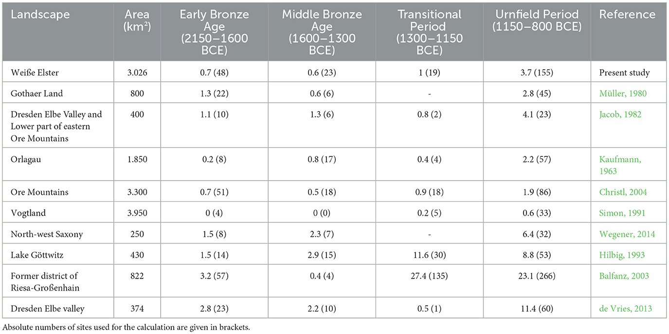
Table 5. Supra-regional comparison of site frequencies per century per 250 km2, calculated based on the chronology for Central Germany (Figure 3).
The dataset for the Bronze Age at the Weiße Elster thus confirms a supra-regional trend in Central Germany that was previously only known from smaller study areas. The closest similarities for the developments in the Weiße Elster catchment are found in adjacent study areas from the Central Uplands. At the same time, differences to the study areas at Lake Göttwitz and Riesa-Großenhain are observed. In the latter regions, there is an increase in the site frequency in the Transitional Period and a decline in the Urnfield Period.
The results of this study represent a novelty, as no quantitative studies on the spatial affinity of Bronze Age sites in Central Germany have been carried out to date. Future studies will show to what extent the observations at the Weiße Elster are a local phenomenon or a reflection of a supra-regional trend. However, Molloy et al. (2023) also observed a drastic change in settlement patterns in the southern Carpathian Basin around 1600 BCE as well. This change may have been triggered by a collapse of the Únětice culture (Shennan, 1993; Kneisel et al., 2013, 2019; Svizzero, 2016, 2018; Großmann et al., 2023).
5.2.2 Bronze Age colonization of low mountain ranges
The settlement dynamics observed at the Weiße Elster confirm earlier observations. These include the finding that most Early Bronze Age sites are located in the Northern German Plains as well as a lack of archaeological evidence indicating a permanent settlement in the Central Uplands during this period (Simon, 1989; Bahn, 1996; Bartelheim, 1996; Christl, 2004; Küßner and Walter, 2019). The same applies to the Middle Bronze Age (Hauswald, 1986; Peschel, 1994; Bahn, 1996; Tellenbach, 1996). The sites from the Transitional Period in the Vogtland are a local peculiarity. So far, there is no other low mountain range region in Central Germany with a comparably high level of settlement activity (Lappe, 1990; Tolksdorf et al., 2019). Excavations in the late 1930s demonstrated that a small settlement enclave had developed during the Bz D phase in the Vogtland (Haase, 1938; Coblenz, 1954, 1986a; Simon, 1991; Christl and Simon, 1995). In this context, it has been pointed out that the Vogtland had a favorable microclimate, which is said to have been enhanced by climatic changes at the end of the Middle Bronze Age (Billig, 1954; Weber and Richter, 1964; Heinrich and Lange, 1969; Simon, 1989, 1991; Christl and Simon, 1995). In contrast to the almost completely empty Ore Mountains (cf. Tolksdorf et al., 2019), the Vogtland is thus considered the “most settlement-friendly upland region in Central Germany” (Christl and Simon, 1995). In addition, the dataset from the Weiße Elster confirms a settlement dynamic for the Urnfield Period that was pointed out early on: During the Ha A and Ha B phases, the settlement density increases considerably and at the same time the low mountain ranges are colonized (Hennig, 1912; Radig, 1934a,b; Pietsch, 1934; Billig, 1954; Peschel, 1969, 1994; Jacob, 1982; Coblenz, 1986b; Hauswald, 1986; Richter, 1986; Lappe, 1990; Simon, 1991; Hilbig, 1993; Nebelsick, 1996; Heynowski, 2010a,b). The intensity of this process and its impact on the environment was even compared to the colonization of the low mountain ranges in the High Middle Ages (Jäger and Ložek, 1978, 1982, 1987).
5.2.3 Site distribution patterns and geostatistics in their regional context
A supra-regional discussion of GIS analyses of Bronze Age land use is only possible based on general remarks as hardly any quantitative analyses have been carried out. Furthermore, the few published studies differ in the general structure of their data and methods (Müller, 1980; Balfanz, 2003; de Vries, 2013; Wegener, 2014). Nevertheless, there is a consensus that Early Bronze Age land use is concentrated on the most fertile soils and that a wider range of less fertile soils was cultivated in the following periods (de Vries, 2013; Wegener, 2014; Küßner and Walter, 2019). This dynamic has been interpreted as an indication of fundamental changes in the economic system, during which the importance of pastoralism is likely to have increased (Jacob, 1982; Müller, 1985; Simon, 1991; Hilbig, 1993; Christl and Simon, 1995; Heynowski, 2010a,b). Moreover, in neighboring study regions it was also observed that Early Bronze Age sites are mainly located on gentle slopes in the lowlands, while higher elevations and steeper slopes are colonized in subsequent periods (Müller, 1980; Balfanz, 2003; de Vries, 2013; Wegener, 2014). In addition, the GIS analyses indicate that the proximity to rivers and streams becomes increasingly important during the Bronze Age and is particularly pronounced between the Transitional Period and the Urnfield Period (Balfanz, 2003). This aspect has often been addressed in earlier studies, but without accompanying statistical analyses (Hennig, 1912; Radig, 1936; Coblenz, 1958; Peschel, 1978; Jacob, 1982; Coblenz, 1986b). This development could be a reaction to the dry climate that has been documented in Central Germany and beyond at this time (Jäger, 2002a,b,c, 2009a; Arosio et al., 2025). However, this trend of increasing proximity to rivers and streams cannot be observed in north-western Saxony and the Dresden Elbe Valley (de Vries, 2013; Wegener, 2014).
5.2.4 Archaeobotanical perspectives on Bronze Age settlement dynamics
The findings on Bronze Age land use are supplemented by archaeobotanical investigations of pollen profiles and analyses of plant remains from settlement pits, hoards and burials (Figure 9). However, the pollen profiles in question from Lake Göttwitz (Jacob, 1957, 1971), Plothen and Pöllwitz (Heinrich and Lange, 1969) were investigated early on, so that the sampling methods no longer meet today's requirements (Schneider, 2025). In addition, their interpretation lacks precise dating. That said, archaeological finds allowed for a provisional dating of Profile III at Lake Göttwitz. The profile indicates a humid climate during the Middle Bronze Age and a drier phase in the Urnfield Period. A high proportion of non-tree pollen from this period also indicates that surrounding forests were thinning during the Transitional Period (Jacob, 1971). This observation is consistent with the archaeological site frequencies in this region (Table 5).
Notably, at Pöllwitz in the Vogtland “a more or less continuous human impact since the Neolithic” was observed (Heinrich and Lange, 1969). However, the human impact on local forests was limited (Heinrich and Lange, 1969; see also Mildenberger's, 1972 critique; Schneider, 2025). Similarly, evidence of Bronze Age land use remains sparse in the Ore Mountains, with only faint traces identified in pollen profiles (Lange et al., 2005; Seifert-Eulen, 2016; Kaiser et al., 2023).
The pollen records from Süßer See are particularly significant for understanding Bronze Age settlement patterns. Here, evidence of pasture farming and cultivation during the Early Bronze Age was confirmed, along with signs of human activity during the Middle Bronze Age (Hellmund et al., 2011; Hellmund and Wennrich, 2014). So far, however, no archaeological finds from the Middle Bronze Age are known from the vicinity of this profile. Therefore, this finding supports the notion that identifying the Middle Bronze Age in the archaeological record is challenging due to culturally intrinsic filters—such as small-scale settlements.
Analyses of large botanical remains from Bronze Age contexts are rare in Central Germany (Hummel, 1968; Matthias and Schultze-Motel, 1971; Schultze-Motel and Gall, 1994; Hellmund, 2012). Among the few known Early Bronze Age contexts, barley, emmer, and einkorn are frequently represented (Coblenz, 1973; Küster, 1996; Jarecki et al., 2007; Hellmund, 2017). By the Transitional Period and Urnfield Period, additional crops such as spelt, millet, lentils, and broad beans appear in the archaeological record. These crops are robust and still produce good yields even on poor soils, making them suitable for the settlement of low mountain ranges (Schultze-Motel and Gall, 1967; Schultze-Motel, 1973; Jäger, 1987, 2008; Falkenstein, 2009; Hellmund, 2012; Hellmund and Petzschmann, 2011; Stika and Heiss, 2013; Filipović et al., 2020). Notably, archaeobotanical studies from the Vogtland provide some of the most detailed insights into plant use during these periods. At sites like Nasser Acker, Hoher Stein, Göse, and Eisenberg, researchers identified virtually all major cereals and legumes cultivated in Central Europe at that time, complemented by a variety of forest fruits (Weber and Richter, 1964). Thus, both archaeological finds as well as archaeobotanical investigations of pollen profiles and plant remains from several settlements together indicate a settlement in the Vogtland during the Transitional Period and the Urnfield Period.
5.3 Driving factors of local settlement dynamics
Discussions about possible driving factors behind Bronze Age settlement dynamics in Central Germany started over 120 years ago. However, a definitive answer to this question has yet to be found, i.e., only hypotheses can be put forward at this point.
Building on the anthropogeographical work of Friedrich Ratzel and Robert Gradmann, soil and climate were among the earliest factors considered central to prehistoric settlement patterns. It was argued that the continuous settlement of the Northern German Plains stemmed from its fertile loess landscapes, which were either largely treeless or only sparsely forested during prehistoric times—unlike the densely wooded low mountain ranges (Hennig, 1912; Leipold, 1934). Though these conclusions relied on historical sources from the Middle Ages, the proposed forest distribution was retroactively applied to earlier periods (Miera, 2022).
This argument was closely tied to the idea that the dry, warm summers of the Early and Middle Bronze Age gradually reshaped the forest landscape, paving the way for settlement in the Vogtland during the Urnfield Period (Leipold, 1934; Radig, 1936; Billig et al., 1957). This assumption drew on pollen analyses from bogs in the Ore Mountains and archaeological and pedological studies of river floodplains (Rudolph and Firbas, 1924; Frenzel, 1930; Braune and Grahmann, 1933; Grahmann, 1934a,b). Later these observations were confirmed by Jäger (1969, 1970, 1997, 2002a,b,c, 2009a,b), reinforcing the long-held association between a climatic optimum and land use in the Vogtland during the Urnfield Period (Simon, 1991; Christl and Simon, 1995; Christl, 2003, 2004; Kenzler, 2012).
Conversely, for the Early and Middle Bronze Age, a cool, humid climate was assumed to have made permanent settlement in low mountain ranges difficult. To avoid crop failures and famine, settlers likely focused instead on more favorable agricultural areas in the lowlands (Simon, 1991; Christl and Simon, 1995). This explanation hinges on aligning archaeological evidence with insights from Holocene climate history. However, to date, no study has directly examined or modeled how Bronze Age economies responded to climatic fluctuations in Central Germany.
In view of stray finds like the copper axe from Treuen in the Vogtland, early research ruled out the possibility of a complete avoidance of the Central Uplands during the Early and Middle Bronze Age (Teuscher, 1911, 1913; Hennig, 1912). Instead, scholars initially proposed that mining may have occurred in the Vogtland (Jacob, 1911; Auerbach, 1925, 1927, 1932; Radig, 1936; Mildenberger, 1959; Kaufmann, 1963; Müller, 1985; Bahn, 1990; Heynowski, 2010c; Kenzler, 2012). However, only indirect evidence of Bronze Age mining has been uncovered so far in the Ore Mountains and Vogtland (Witter, 1938; Otto and Witter, 1952; Kaufmann, 1961; Bouzek et al., 1982; Coblenz, 1982; Simon, 1992, 1993; Bartelheim and Niederschlag, 1998; Tolksdorf et al., 2019; Hemker et al., 2020).
It was also suggested that demographic changes influenced settlement patterns, especially during the Urnfield Period's significant territorial expansion (Auerbach, 1927; Radig, 1934a; Kaufmann, 1963; Bahn, 1990; Lappe, 1986b; Innerhofer, 2010). However, this idea remains a working hypothesis that requires further testing and support from archaeological, anthropological evidence and/or environmental data (cf. Heynowski, 2010a).
6 Conclusion
The present study focused on the systematic processing and source critical analysis of Bronze Age sites, as well as the identification and supra-regional contextualization of settlement dynamics observed in the Weiße Elster catchment. The starting point was a database of 367 sites. The main results are summarized as follows:
• The case study underlines the importance of local archaeological archives as more than half of the recorded sites had not been published at the time of data collection.
• Based on an analysis of archaeological and geographical filters, it is possible to infer basic settlement patterns from the dataset. Neither field surveys nor aerial photography have distorted the distribution of sites. Additionally, over 70% of the study area is covered by land use categories that increase the chances of discovering archaeological sites. However, source analyses indicate that Bronze Age pottery is less visible on the surface. This could be due to reduced visibility and poor preservation conditions of coarse and poorly fired settlement pottery, which is often heavily fragmented as it is more vulnerable to weathering.
• The dating of the archaeological material and the determination of site frequencies pose a challenge because several chronological systems are used in Central Germany and their synchronization is still subject to revision. Overall, the site frequencies at the Weiße Elster vary slightly from the Early Bronze Age to the Transitional Period and rise sharply in the Urnfield Period. This pattern can is observed in adjacent study areas from the low mountain ranges as well.
• The analysis of culturally intrinsic filters reveals distortions in the frequency distribution of settlements, burial sites, and stray finds across the Bronze Age. Fewer burial sites than settlements are known from the Early Bronze Age and Urnfield Period. In contrast, the Middle Bronze Age is primarily documented by stray finds, while the Transitional Period is identified primarily based on funerary pottery. These filters have also been observed in other regions of Central Germany and are therefore not limited to the Weiße Elster.
• The spatial distribution of Early Bronze Age sites is characterized by concentrations of sites along the Weiße Elster in the Northern German Plains. In addition, isolated sites are known from the Central Uplands. This pattern persists in the Middle Bronze Age, although the distances between the sites along the Weiße Elster increase to such an extent that only a very small concentration of sites can be identified near Leipzig. The distribution of sites from the Transitional Period is so loose that no focal points of settlement can be discerned. However, there is a slight increase in the number of sites in the Central Uplands. In contrast, the sites from the Urnfield Period are mainly concentrated in the Northern German Plains. There are also clusters of sites along the Weiße Elster near Gera and Plauen in the Vogtland. It has also been observed in adjacent landscapes that Early Bronze Age sites are concentrated in the lowlands and that a more extensive exploitation of low mountain ranges sets in during the Urnfield Period.
• Through the analyses of Site Exploitation Territories it is possible to quantitatively characterize the main settlement dynamics between the Northern German Plains and the low mountain ranges of the Central German Uplands using selected terrain covariates. The dominance of soil on loess in the immediate vicinity of settlements is characteristic of the Early Bronze Age. In the subsequent periods, this focus was dropped. Overall, the present study puts the observations from older studies on a new and more precise footing using a systematized data set and geostatistical methods.
• The distribution of Early Bronze Age sites shows a pronounced spatial affinity to Late Neolithic sites. With the transition to the Middle Bronze Age, all previously occupied sites are abandoned. In the Transitional Period, however, many Middle Bronze Age settlements and burial sites continued to be used. During the Urnfield Period, there is another change of sites and a decline in spatial affinity. Comparable studies from other regions of Central Germany are still lacking, so that these results initially stand alone. However, the abandonment of Early Bronze Age sites in the Middle Bronze Age has been observed in the Carpathian basin as well. This process has been considered as the result of a collapse at the end of the Únětice culture around 1600 BCE.
Data availability statement
The original contributions presented in the study are included in the article/Supplementary material, further inquiries can be directed to the corresponding author.
Author contributions
JM: Data curation, Methodology, Conceptualization, Investigation, Writing – review & editing, Formal analysis, Writing – original draft.
Funding
The author(s) declare that financial support was received for the research and/or publication of this article. This study was financially supported by the DFG-funded project “Imprints of Rapid Climate Changes and human activity on Holocene hydrosedimentary dynamics in Central Europe (loess-covered Weiße Elster model region)” (ET20/10-1, SU491/6-1, VE117/7-1, ZI721/13-1). The author acknowledges support by the Open Access Publishing Fund of Leipzig University.
Acknowledgments
The author thanks Regina Smolnik from the Saxonian Archaeological Heritage Office, Harald Meller from the State Office for Preservation of Monuments and Archaeology Saxony-Anhalt, and Sven Ostritz from the Thuringian State Office for Heritage Management and Archaeology for providing access to local area files. In addition, thanks are due to Ronald Heynowski, Reiner Göldner from the Saxonian Archaeological Heritage Office, Verena Junski from the State Office for Preservation of Monuments and Archaeology Saxony-Anhalt and Ilona Nestler from the Thuringian State Office for Heritage Management and Archaeology for supporting the corresponding author during his work with the local area files. I would also like to thank Bella Everest for reaching out to me and encouraging me to submit to Frontiers in Environmental Archaeology. Finally, I want to thank the academic editor Laurent Lespez and two reviewers for their kind feedback and constructive comments. This paper is dedicated to Professor Dr. Ulrich Veit on the occasion of his 65th birthday. The author wishes to express heartfelt thanks for many years of inspiring collaboration and stimulating conversations in Leipzig. With warmest wishes to Ulrich Veit for continued joy, good health, and happiness in the years ahead.
Conflict of interest
The author declares that the research was conducted in the absence of any commercial or financial relationships that could be construed as a potential conflict of interest.
Generative AI statement
The author(s) declare that no Gen AI was used in the creation of this manuscript.
Publisher's note
All claims expressed in this article are solely those of the authors and do not necessarily represent those of their affiliated organizations, or those of the publisher, the editors and the reviewers. Any product that may be evaluated in this article, or claim that may be made by its manufacturer, is not guaranteed or endorsed by the publisher.
Supplementary material
The Supplementary Material for this article can be found online at: https://www.frontiersin.org/articles/10.3389/fearc.2025.1642403/full#supplementary-material
References
Agde, H. (1935). Die Kultur der thüringischen Steinpackungsgräber der Bronzezeit. Halle/Saale: Gebauer-Schwetschke.
Ahlrichs, J. J., Henkner, J., and Schmidt, K. (2016). A seamless workflow for defining archaeological site densities with contour lines by using the open source (geo-)statistical language R. Collaborative Research Center 1070 - Geoscientific and archaeological research. Technical note. Available online at: https://uni-tuebingen.de/de/75294 (Accessed May 1, 2025).
Ahlrichs, J. J., Henkner, J., Schmidt, K., Scholten, T., Kühn, P., Knopf, T., et al. (2018). “Bronzezeitliche Siedlungsdynamiken zwischen der Baar und angrenzenden Naturräumen”, in Bronzezeitlicher Transport: Akteure, Mittel und Wege, eds. D. Neumann, B. Nessel, and M. Bartelheim (Tübingen: Tübingen University Press), 269–303.
Aichinger, M., and Grasselt, T. (2010). 100 Jahre Die vor- und frühgeschichtlichen Altertümer Thüringens: Beiträge zur Geschichte der archäologischen Denkmalpflege in Thüringen. Langenweißbach: Beier & Beran.
Amende, E. (1928). Führer durch die vorgeschichtliche Sammlung des Altenburger Heimatmuseums, zugleich eine Vorgeschichte des Altenburger Landes. Mitteilungen der Geschichts- und Altertumsforschenden Gesellschaft des Osterlandes 13, 107–184.
Arosio, T., Leuenberger, M., Nicolussi, K., Esper, J., Krusic, P. J., Bebchuk, T., et al. (2025). Tree-ring stable isotopes from the European Alps reveal long-term summer drying over the Holocene. Sci. Adv. 11:eadr4161. doi: 10.1126/sciadv.adr4161
Auerbach, A. (1925). “Bruchstücke einer verlorenen Gußform aus Ostthüringen”, in Studien zur vorgeschichtlichen Archäologie: Alfred Götze zu seinem 60. Geburtstage, ed. H. Mötefindt (Leipzig: Kabitzsch), 165–169.
Auerbach, A. (1927). Vor- und Frühgeschichte des Gebiets von Ostthüringen zwischen Elster und Saale. Weida: Ortsgeschichtlicher Verein.
Auerbach, A. (1932). Übersicht über die Vor- und Frühgeschichte Ostthüringens. Jahresbericht des Vogtländischen Altertumsforschenden Vereins Hohenleuben 91–102, 1–77.
Bahn, B. W. (1990). “Siedlungsgeographische Bemerkungen zur Bronzezeit im Mittelgebirgsbereich”, in Beiträge zur Geschichte und Kultur der mitteleuropäischen Bronzezeit, eds. B. Chropovský and J. Hermann (Nitra: Archeologický ústav), 21–43.
Bahn, B. W. (1996). Die Vor- und Frühgeschichte des Burgenlandkreises. Archäologische Berichte aus Sachsen-Anhalt 1995, 193–291.
Bailey, G. N., and Davidson, I. (1983). Site exploitation territory and topography: two case studies from palaeolithic Spain. J. Archaeol. Sci. 10, 87–115. doi: 10.1016/0305-4403(83)90044-4
Balfanz, I. (2003). Die ur- und frühgeschichtliche Besiedlung des Kreises Riesa-Großenhain (Reg.-Bez. Dresden). Halle/Saale: Martin-Luther-Universität Halle-Wittenberg.
Ballasus, H., Schneider, B., von Suchodoletz, H., Miera, J., Werban, U., Fütterer, P., et al. (2022). Overbank silt-clay deposition and intensive Neolithic land use in a Central European catchment - Coupled or decoupled? Sci. Total Environ. 806:150858. doi: 10.1016/j.scitotenv.2021.150858
Barceló, J. A. (2018). “Chi-square analysis”, in The Encyclopedia of Archaeological Sciences, ed. S. L. López Varela (Malden: Wiley). doi: 10.1002/9781119188230.saseas0090
Bartelheim, M. (1996). “Die Frühbronzezeit”, in Leipzig und sein Umland: Archäologie zwischen Elster und Mulde, ed. J. Oexle (Stuttgart: Theiss) 53–60.
Bartelheim, M., and Niederschlag, E. (1998). Untersuchungen zur Buntmetallurgie, insbesondere des Kupfers und des Zinns, im sächsisch-böhmischen Erzgebirge und dessen Umland. Arbeits- und Forschungsberichte zur sächsischen Bodendenkmalpflege 40, 8–87.
Bartelt, U. (2004). Beste Wohnlage am Auenrand der Weißen Elster - Siedlungsbefunde vom Frühneolithikum bis in die Eisenzeit bei Großdalzig, Lkr. Leipziger Land. Arbeits- und Forschungsberichte zur sächsischen Bodendenkmalpflege 46, 115–173.
Barthel, S. (1972). “Unstrutgruppe”, in Typentafeln zur Ur- und Frühgeschichte, ed. R. Feustel (Weimar: Kulturbund) Bronzezeit, Blatt 7–8.
Becker, M., Fröhlich, M., Balfanz, K., Kromer, B., and Friedrich, R. (2015). “Das 3. Jt. v. Chr. zwischen Saale und Unstrut - Kulturelle Veränderungen im Spiegel der Radiokohlenstoffdatierung”, in 2200 BC - ein Klimasturz als Ursache für den Zerfall der alten Welt? 7. Mitteldeutscher Archäologentag vom 23. bis 26. Oktober 2014 in Halle (Saale), ed. H. Meller (Halle/Saale: Landesamt für Denkmalpflege und Archäologie Sachsen-Anhalt, Landesmuseum für Vorgeschichte), 715–745.
Billig, G. (1954). Ur- und Frühgeschichte des sächsischen Vogtlandes. Eine populärwissenschaftliche Einführung in die urgeschichtliche Heimatforschung und ein Führer zur ur- und frühgeschichtlichen Abteilung des vogtländischen Kreismuseums in Plauen. Plauen: Rat des Stadtkreises Plauen.
Billig, G. (1968). Jungbronzezeitliche Steinpackungsgräber von Rumpin, Saalkreis. Jahresschrift für mitteldeutsche Vorgeschichte 52, 81–130.
Billig, G., Radig, W., Richter, J., and Schmidt, F. L. (1957). Probleme der frühgeschichtlichen Besiedlung im Vogtland. Jahrbuch des Kreismuseums Hohenleuben-Reichenfels 6, 5–17.
Bouzek, J. (1967). Böhmen, Sachsen und Mitteldeutschland. Bemerkungen zur vergleichenden Chronologie der Urnenfelderzeit. Arbeits- und Forschungsberichte zur sächsischen Bodendenkmalpflege 16/17, 73–92.
Bouzek, J., Koutecký, D., and Neustupný, E. (1966). The Knovíz Settlement of North-west Bohemia: knovízské osídlení severozápadních Cech. Prag: Museum nationale.
Bouzek, J., Koutecký, D., and Simon, K. (1982). Tin and prehistoric mining in the Erzgebirge (Ore Mountains): Some new evidence. Oxford J. Archaeol. 8, 203–212. doi: 10.1111/j.1468-0092.1989.tb00200.x
Braune, K., and Grahmann, R. (1933). Bronzezeitliche und slawische Herdstellen in der Pleißeaue bei Markkleeberg. Die Fundpflege 1, 44–45.
Brunner, M., von Felten, J., Hinz, M., and Hafner, A. (2020). Central European early bronze age chronology revisited: a Bayesian examination of large-scale radiocarbon dating. PLoS ONE 15:e0243719. doi: 10.1371/journal.pone.0243719
Buck, D.-W. (1972). “Lausitzer Kultur”, in Typentafeln zur Ur- und Frühgeschichte, ed. R. Feustel (Weimar: Kulturbund) Bronzezeit, Blatt 5–6.
Buck, D.-W. (1989). Zur chronologischen Gliederung der Lausitzer Gruppe. Veröffentlichungen des Museums für Ur- und Frühgeschichte Potsdam 23, 75–95.
Bundesamt für Karthographie und Geodäsie (BKG) (2024). Verwaltungsgebiete 1:250 000, Stand 31.12. (VG250 31.12.). Available online at: https://gdz.bkg.bund.de/index.php/default/digitale-geodaten/verwaltungsgebiete/verwaltungsgebiete-1-250-000-stand-31-12-vg250-31-12.html (Accessed May 1, 2025).
Christl, A. (1989). Höhengrenzen der urgeschichtlichen Besiedlung im Erzgebirge und dessen Umland, dargestellt an einem Ausschnitt. Archeologické rozhledy 41, 386–405.
Christl, A. (2003). Höhenabhängige Differenzierung der ur- und frühgeschichtlichen Besiedlung am Erzgebirge sowie Diskussion ihrer Ursachen - dargestellt am mittleren Bereich. Archäologisches Nachrichtenblatt 8, 78–84.
Christl, A. (2004). Verschiebungen der Höhengrenzen der ur- und frühgeschichtlichen Besiedlung am Erzgebirge. Langenweissbach: Beier & Beran.
Christl, A., and Simon, K. (1995). Nutzung und Besiedlung des sächsischen Erzgebirges und des Vogtlandes bis zur deutschen Ostkolonisation. Germania 73, 441-462.
Coblenz, W. (1950). Die Stellung der oberen Elbe bei der Ausbreitung der Lausitzer Kultur. Praehist. Z. 34/35, 62–75. doi: 10.1515/prhz.1950.34-35.1.62
Coblenz, W. (1954). Keramik mit Knoviser Anklängen aus dem Vogtland. Arbeits- und Forschungsberichte zur sächsischen Bodendenkmalpflege 4, 337–392.
Coblenz, W. (1961a). “Bemerkungen zum Forschungsstand über die Vorlausitzer Kultur nördlich vom Erzgebirge und Lausitzer Bergland”, in Kommission für das Äneolithikum und die Ältere Bronzezeit: Nitra 1958, ed. A. Točik (Bratislava: Vydavatel'stvo Slovenskej Akad. Vied) 185–196.
Coblenz, W. (1961b). Böhmisch-sächsische Kontakte während der Lausitzer Kultur. Památky archeologické 52, 362–373.
Coblenz, W. (1963). Die Übergänge vom Erzgebirge bis zum Lausitzer Bergland in ur- und frühgeschichtlicher Zeit. Acta Archaeologica Carpathica 5, 177–180.
Coblenz, W. (1966). Zur Stellung der Oberlausitz im Passland Sachsen. Jahrbuch des Römisch-Germanischen Zentralmuseums Mainz 11, 115–125.
Coblenz, W. (1969). “Bemerkungen zum Stand der Forschungen über die Lausitzer Kultur”, in Beiträge zur Lausitzer Kultur: Referate der Internationalen Arbeitstagung zu Problemen der Lausitzer Kultur vom 24. bis 26. November 1967 in Dresden, ed. W. Coblenz (Berlin: Deutscher Verlag der Wissenschaften) 11–24.
Coblenz, W. (1971). Die Lausitzer Kultur der Bronze- und frühen Eisenzeit Ostmitteleuropas als Forschungsproblem. Ethnographisch-archäologische Zeitschrift 12, 425–438. doi: 10.54799/SCHS4677
Coblenz, W. (1973). Eine Aunjetitzer Vorratsgrube mit Getreide aus Döbeln-Mastern. Ausgrab. Funde 18, 70–80.
Coblenz, W. (1982). Bronzebeschaffung und -verarbeitung während der Aunjetitzer und Lausitzer Kultur in Sachsen. Archeologia Polski 27, 323–334.
Coblenz, W. (1986a). Zu bronzezeitlicher Nutzung und Besiedlung der Sächsischen Schweiz und des östlichen Erzgebirgsrandes. Arbeits- und Forschungsberichte zur sächsischen Bodendenkmalpflege 30, 89–109.
Coblenz, W. (1986b). Bemerkungen zu den offenen und befestigten Siedlungen sowie den Gräberfeldern im Bereich der sächsisch-lausitzischen Gruppe. Veröffentlichungen des Museums für Ur- und Frühgeschichte Potsdam 20, 99–112.
Coblenz, W. (1987). “Die Urnenfelder Sachsen und ihre Beziehungen zum Osten und Süden”, in Die Urnenfelderkulturen Mitteleuropas: Symposium Liblice 21.-25.10.1985, ed. E. Plesl (Prag: Archäologisches Institut der Tschechoslowakischen Akademie der Wissenschaft), 89–98.
Coblenz, W. (1990). “Vorläufer und Anfänge der Lausitzer Kultur in Sachsen,” in Beiträge zur Geschichte und Kultur der mitteleuropäischen Bronzezeit, eds. B. Chropovský and J. Hermann (Nitra: Archeologický ústav), 101–117.
Coblenz, W. (1991). “Die Anfänge der Lausitzer Kultur nördlich der Mittelgebirge zwischen Neiße und Elster”, in Die Anfänge der Urnenfelderkulturen in Europa = Poczatki kultur pól popielnicowych w Europie, ed. M. Gedl (Warszawa: Wydawnictwa Uniwersytetu Warszawskiego), 109–122.
Conrad, M., Dreßler, J., Krämer, U., Kreienbrink, F., Schindler, A., Stäuble, H., et al. (2016). Siedlungen, Gräber und Werkplätze. Die Ausgrabungen an der Ferngasleitung 2 zwischen Lauchhammer und Weißig. Ausgrabungen in Sachsen 5, 248–261.
Conrad, O., Bechtel, B., Bock, M., Dietrich, H., Fischer, E., Gerlitz, L., et al. (2015). System for automated geoscientific analyses (SAGA) v. 2.1.4. Geosci. Model Dev. 8, 1991–2007.doi: 10.5194/gmd-8-1991-2015
Conrad, S., Conrad, M., Ender, W., Tinapp, C., and Herbig, C. (2016). Die vor- und frühgeschichtliche Besiedlung im Döllnitztal bei Göttwitz (Stadt Grimma, Lkr. Leipzig). Ausgrabungen in Sachsen 5, 182–200.
Conrad, S., Conrad, M., and Herbig, C. (2014). Mittelneolithische, bronzezeitliche und kaiserzeitliche Siedlungsspuren nördlich des Seniorenheims Mügeln. Ausgrabungen in Sachsen 4, 115–120.
Dauber, A. (1950). “Der Forschungsstand als innere Gültigkeitsgrenze der Fundkarte”, in Ur- und Frühgeschichte als historische Wissenschaft. Festschrift zum 60. Geburtstag von Ernst Wahle, ed. H. Kirchner (Heidelberg: Winter), 94–111.
de Vries, P. (2013). Prähistorische Siedlungsplatzwahl in der Dresdner Elbtalweitung. Dresden: Landesamt für Archäologie, Freistaat Sachsen.
Donat, P. (1969). Ein Beitrag zur relativen Chronologie der Hügelgräberbronzezeit Südwestthüringens. Zeitschrift für Archäologie 3, 16–36.
DWD Climate Data Center (2018a). Multi-annual means of grids of air temperature (2m) over Germany 1981-2010, version v1.0. Available online at: ftp://opendata.dwd.de/climate_environment/CDC/grids_germany/multi_annual/ (Accessed May 1, 20250.
DWD Climate Data Center (2018b). Multi-annual grids of precipitation height over Germany 1981-2010, version v1.0. Available online at: ftp://opendata.dwd.de/climate_environment/CDC/grids_germany/multi_annual/ (Accessed May 1, 2025).
DWD Climate Data Center (2018c). Multi-annual grids of number of frost days over Germany, version v1.0. Available online at: ftp://opendata.dwd.de/climate_environment/CDC/grids_germany/multi_annual/ (Accessed May 1, 2025).
DWD Climate Data Center (2018d). Multi-annual grids of annual sunshine duration over Germany 1981-2010, version v1.0. Available online at: ftp://opendata.dwd.de/climate_environment/CDC/grids_germany/multi_annual/ (Accessed May 1, 2025).
Ebner, K. (2001). Eine Flachlandsiedlung der ausgehenden Bronze- und älteren Eisenzeit am Ortsrand von Pößneck, Saale-Orla-Kreis. Alt Thuring. 34, 135–173.
Eckmeier, E., Pätzold, S., Lehndorff, E., and Gerlach, R. (2011). “Geochemische Untersuchungen von Böden zur Rekonstruktion der prähistorischen Landnutzungsgeschichte”, in Umweltarchäologie: Naturkastastrophen und Umweltwandel im archäologischen Befund. 3. Mitteldeutscher Archäologentag vom 7.-9. Oktober 2010, eds. H. R. Bork, H. Meller, and R. Gerlach (Halle/Saale: Landesamt für Denkmalpflege und Archäologie Sachsen-Anhalt, Landesmuseum für Vorgeschichte), 37–45.
Eggert, M. K. H. (2012). Prähistorische Archäologie: Konzepte und Methoden. Tübingen: Narr, Francke, Attempto. doi: 10.36198/9783838536965
Eggert, M. K. H., and Samida, S. (2013). Ur- und frühgeschichtliche Archäologie. Tübingen: Narr, Francke, Attempto. doi: 10.36198/9783838538907
Emmert, U., Horsting, V. G., Stettner, G., and Zitzmann, A. (1981). Geologische Übersichtskarte der Bundesrepublik Deutschland 1:200.000, Blatt CC 6334 Bayreuth. Hannover: Bundesanstalt für Geowissenschaften und Rohstoffe.
Engel, C. (1933). Einführung in die Vorgeschichte Mitteldeutschlands. Zugleich Erläuterungen Benndorfs Tafeln vorgeschichtlicher Gegenstände aus Mitteldeutschland. Band 1: Stein- und Bronzezeit. Leipzig: Brandstetter.
European Environment Agency (2007). CLC2006 technical guidelines. EEA Technical Report 17/2007. Copenhagen: EEA.
European Environment Agency (2012). Catchments and Rivers Network System ECRINS v1.1. Rationales, Building and Improving for Widening Uses to Water Accounts and WISE Applications. EEA Technical Report 7/2012. Copenhagen: EEA.
Falkenstein, F. (2009). “Zur Subsistenzwirtschaft der Bronzezeit in Mittel- und Südosteuropa”, in Die wirtschaftlichen Grundlagen der Bronzezeit Europas, eds. M. Bartelheim and H. Stäuble (Rahden/Westf.: Leidorf), 147–176.
Farr, T. G., Rosen, P. A., Caro, E., Crippen, R., Duren, R., Hensley, S., et al. (2007). The Shuttle Radar Topography Mission. Rev. Geophys. 45, 1–33. doi: 10.1029/2005RG000183
Fender, P. (2017). Bayern in der Vorgeschichte - Eine GIS-gestützte Analyse der Siedlungslandschaft und der Einsatz von Open Data in der Archäologie. Marburg: Philipps-Universität Marburg.
Feustel, R. (1958a). Bronzezeitliche Hügelgräberkultur im Gebiet von Schwarza (Südthüringen). Weimar: Böhlau.
Feustel, R. (1972). “Bronzezeitliche Hügelgräberkultur”, in Typentafeln zur Ur- und Frühgeschichte, ed. R. Feustel (Weimar: Kulturbund), Bronzezeit, Blatt, 3–4.
Filipović, D., Meadows, J., Dal Corso, M., Kirleis, W., Alsleben, A., Akeret, Ö., et al. (2020). New AMS 14C dates track the arrival and spread of broomcorn millet cultivation and agricultural change in prehistoric Europe. Sci. Rep. 10:13698. doi: 10.1038/s41598-020-70495-z
Frank, T. (2007). Zur Bedeutung der Tätigkeit von Sammlern für die Archäologie. Die Kunde 58, 91–106.
Frehse, D., Strobel, M., and Wegener, R. (2012). Alt bekannt und doch neu: spätneolithische und jungbronzezeitliche Siedlungsspuren bei Folbern. Ausgrabungen in Sachsen 3, 51–55.
Frenzel, H. (1930). Entwicklungsgeschichte der sächsischen Moore und Wälder seit der letzten Eiszeit: Auf Grund pollenanalytischer Untersuchungen. Dresden: Geologisches Landesamt.
Fröhlich, S. (1983). Studien zur mittleren Bronzezeit zwischen Thüringer Wald und Altmark, Leipziger Tieflandsbucht und Oker. Braunschweig: Braunschweigisches Landesmuseum.
Fröhlich, S. (1998). “Gefährdet - geborgen - gerettet: archäologische Ausgrabungen,” in Sachsen-Anhalt von 1991 bis 1997. Begleitband zur Sonderausstellung, Landesmuseum für Vorgeschichte Halle (Saale), 03.07.1998 bis 30.11.1998 (Halle/Saale: Landesmuseum für Vorgeschichte).
Fuente, G. A. d. l. (2008). Post-Depositional Chemical Alterations in Archaeological Ceramics: a critical review and implications for their conservation. Boletín del Laboratorio de Petrología y Conservación Cerámica 1, 21–37.
Ganslmeier, R. (2011). “Funde der Mittel- und Jungbronzezeit sowie der älteren Eisenzeit in Schnitt 15 (Tell)”, in Kultur in Schichten: Archäologie am Autobahndreieck Südharz (A71), eds. H. Meller and S. Friederich (Halle/Saale: Landesamt für Denkmalpflege und Archäologie Sachsen-Anhalt, Landesmuseum für Vorgeschichte), 133–138.
Gebhard, K. (2007). Die vorgeschichtliche Besiedlung des Kreises Groß-Gerau. Wiesbaden: Landesamt für Denkmalpflege Hessen.
Geilmann, W., and Spang, A. (1958). Eine Beobachtung zur Schnelligkeit der Zerstörung keramischer Scherben auf der Erdoberfläche. Die Kunde 9, 93–94.
Gerhard, S. (2006). Beiträge zur archäologischen Quellenkritik an Beispielen aus dem Neolithikum und der Frühbronzezeit Südbayerns. Erlangen: Faustus.
Gerlach, R. (2006). Holozän: Die Umgestaltung der Landschaft durch den Menschen seit dem Neolithikum. Jahrbuch des Rheinischen Vereins für Denkmalpflege und Landschaftsschutz 2005, 87–98.
Gerlach, R., and Meurers-Balke, J. (2017). Trockentäler im Neolithikum - neue Bäche in der Eisenzeit. Geogr. Rundsch. 69, 32–33.
Götze, A., Höfer, P., and Zschiesche, P. (1909). Die vor- und frühgeschichtlichen Altertümer Thüringens. Im Auftrage thüringischer Geschichtsvereine und wissenschaftlicher Korporationen mit Unterstützung der Staatsregierungen von Preussen, Sachsen-Weimar, Sachsen-Coburg-Gotha, Schwarzburg-Rudolstadt und Schwarzburg-Sondershausen. Würzburg: Kabitzsch.
Grahmann, R. (1934a). Spät- und postglaziale Süßwasserbildungen in Regis-Breitingen und die Entwicklung der Urlandschaft in Westsachsen. Mitteilungen aus dem Osterlande, Neue Folge 22, 14–44.
Grahmann, R. (1934b). Konnten die mitteldeutschen Flußauen in vorgeschichtlicher Zeit besiedelt werden? Mannus 26, 37–41.
Gramsch, A. (2010). Ritual und Kommunikation: Altersklassen und Geschlechterdifferenz im spätbronze- und früheisenzeitlichen Gräberfeld Cottbus Alvensleben-Kaserne (Brandenburg). Bonn: Habelt.
Großmann, R., Weinelt, M., and Müller, J. (2023). Demographic dynamics between 5500 and 3500 calBP (3550-1550 BCE) in selected study regions of Central Europe and the role of regional climate influences. PLoS ONE 18:e0291956. doi: 10.1371/journal.pone.0291956
Grünberg, W. (1943). Die Grabfunde der jüngeren und jüngsten Bronzezeit im Gau Sachsen. Berlin: de Gruyter. doi: 10.1515/9783111385808
Grunwald, S., Halle, U., Mahsarski, D., and Reichenbach, K. (2016). Die Spur des Geldes in der Prähistorischen Archäologie: Mäzene - Förderer - Förderstrukturen. Bielefeld: Transcript Verlag. doi: 10.14361/9783839431139
Grygar, T. M. (2022). Comment to Ballasus et al. (2022). Sci. Total Environ. 838:155371. doi: 10.1016/j.scitotenv.2022.155371
Gummel, H. (1938). Forschungsgeschichte in Deutschland. Berlin: de Gruyter. doi: 10.1515/9783111613512
Hansen, D. (2019). “Die frühbronzezeitlichen Siedlungsspuren von Zwenkau-West, Lkr. Leipzig (Sachsen)”, in Der Aufbruch zu neuen Horizonten: neue Sichtweisen zur europäischen Frühbronzezeit. Abschlusstagung der Forschergruppe FOR550 vom 26. bis 29. November 2010 in Halle (Saale), eds. H. Meller and F. Bertemes (Halle/Saale: Landesamt für Denkmalpflege und Archäologie Sachsen-Anhalt, Landesmuseum für Vorgeschichte), 345–358.
Härke, H. (2000). Archaeology, Ideology and Society: the German Experience. Frankfurt am Main: Lang.
Hartwich, R., Behrens, J., Eckelmann, W., Haase, G., Richter, A., Roeschmann, G., et al. (1998). Bodenübersichtskarte der Bundesrepublik Deutschland im Maßstab 1:1000000 (BÜK 100). Hannover: Bundesanstalt für Geowissenschaften und Rohstoffe.
Hauswald, K. (1986). Zur urgeschichtlichen Besiedlung der Sächsischen Schweiz im Bereich der Königsteiner Elbschleife. Arbeits- und Forschungsberichte zur sächsischen Bodendenkmalpflege 30, 111–129.
Heinrich, W., and Lange, E. (1969). Ein Beitrag zur Kenntnis der Waldgeschichte des Thüringisch-Sächsischen Vogtlandes. Feddes Repert. 80, 437–462. doi: 10.1002/fedr.19690800411
Hellmund, M. (2012). Ein spätbronzezeitlicher Getreidevorrat von Schafstädt, Saalekreis. Archäologie in Sachsen-Anhalt 6, 304–315.
Hellmund, M. (2017). “Pflanzenreste aus archäologischen Befunden der Schnurkeramik-, Glockenbecher- und Aunjetitzer Kultur im südlichen Sachsen-Anhalt,” in Neue Gleise auf alten Wegen II: Jüdendorf bis Gröbers, eds. H. Meller and M. Becker (Halle/Saale: Beier & Beran), 202–218.
Hellmund, M., and Petzschmann, U. (2011). “Verkohlte Getreidereste in großen Mengen,” in Kultur in Schichten: Archäologie am Autobahndreieck Südharz (A71), eds. H. Meller and S. Friederich (Halle/Saale: Landesmuseum für Vorgeschichte), 191–200.
Hellmund, M., and Wennrich, V. (2014). Zur Vegetationsentwicklung im östlichen Harzvorland : Ein Pollendiagramm vom Süßen See, Lkr. Mansfeld-Südharz. Archäologie in Sachsen Anhalt. Neue Folge 7, 40–54.
Hellmund, M., Wennrich, V., Becher, H., Krichel, A., Bruelheide, H., Melles, M., et al. (2011). “Zur Vegetationsgeschichte im Umfeld des Süßen Sees, Lkr. Mansfeld-Südharz - Ergebnisse von Pollen- und Elementanalyse,” in Umweltarchäologie - Naturkatastrophen und Umweltwandel im archäologischen Befund. 3. Mitteldeutscher Archäologentag vom 07. bis 09. Oktober 2010, eds. H.-R. Bork, H. Meller and R. Gerlach (Halle/Saale: Landesamt für Denkmalpflege und Archäologie Sachsen-Anhalt, Landesmuseum für Vorgeschichte), 111–127.
Hemker, C., Tolksdorf, J. F., and Schubert, M. (2020). Neue Erkenntnisse zum bronzezeitlichen Zinnbergbau im Erzgebirge: montanarchäologische Untersuchungen der Zinnseife bei Schellerhau, Lkr. Sächsische Schweiz-Osterzgebirge. Ausgrabungen in Sachsen 7, 152–162.
Heynowski, R. (2010a). Ortsaktenarchiv und Grabungsdokumentation. Arbeits- und Forschungsberichte zur sächsischen Bodendenkmalpflege 21, 167–172.
Heynowski, R. (2010b). “Jüngere Bronzezeit,” in Atlas zur Geschichte und Landeskunde von Sachsen. Ur- und Frühgeschichte Sachsens: Beiheft zur Karte B I 1.1-1.5, eds. R. Heynowski and R. Reiß (Leipzig: Landesvermessungsamt Sachsen), 85–89.
Heynowski, R. (2010c). “Lausitzer Kultur - Stufe der scharfkantigen, gerillten Ware, Stufe der waagerecht gerieften Ware,” in Atlas zur Geschichte und Landeskunde von Sachsen. Ur- und Frühgeschichte Sachsens: Beiheft zur Karte B I 1.1-1.5, eds. R. Heynowski and R. Reiß (Leipzig: Landesvermessungsamt Sachsen), 91–97.
Higgs, E. S. (1972). “Papers in economic prehistory,” in Studies by Members and Associates of the British Academy Major Research Project in the Early History of Agriculture (Cambridge: Cambridge University Press).
Higgs, E. S. (1975). Palaeoeconomy: being the second volume of Papers in Economic Prehistory by members and associates of the British Academy Major Research Project in the Early History of Agriculture (Cambridge: Cambridge University Press).
Higgs, E. S., and Vita-Finzi, C. (1972). “Prehistoric economies: a territorial approach,” in Papers in Economic Prehistory. Studies by Members and Associates of the British Academy Major Research Project in the Early History of Agriculture, ed. E. S. Higgs (Cambridge: Cambridge University Press), 27–38.
Hilbig, O. (1993). Zur Besiedlungsgeschichte im Gebiet um den Göttwitzer See, Kr. Grimma (Sachsen). Arbeits- und Forschungsberichte zur sächsischen Bodendenkmalpflege 36, 7–65.
Hinz, M. (2014). Neolithische Siedlungsstrukturen im südöstlichen Schleswig-Holstein: Dynamik in Landschaft und Besiedlung. Bonn: Habelt. doi: 10.38071/2024-00729-9
Homann, A., and Hubensack, V. (2016). Bronzezeitliche Befunde und Funde in Eula und Hain, Lkr. Leipzig. Ergebnisse der Grabungen EUL-07 und HAN-04 auf der Trasse BAB 72. Ausgrabungen in Sachsen 5, 95–101.
Horst, F. (1972). Jungbronzezeitliche Formenkreise im Mittelelb-Havel-Gebiet. Jahresschrift für mitteldeutsche Vorgeschichte 56, 97–165.
Horst, F. (1987). “Die Elbe - Mittler zwischen den bronzezeitlichen Stämmen Mitteleuropas,” in Die Urnenfelderkulturen Mitteleuropas: Symposium Liblice 21.-25.10.1985, ed. E. Plesl (Praha: Archäologisches Institut der Tschechoslowakischen Akademie der Wissenschaft), 79–87.
Horst, F. (1989). “Die Stämme der Lausitzer Kultur und des Nordens in der jüngeren Bronzezeit,” in Archäologie in der Deutschen Demokratischen Republik, Band 1: Archäologische Kulturen, geschichtliche Perioden und Volksstämme, ed. J. Herrmann (Leipzig: Urania-Verlag), 98–105.
Hubensack, V. (2018a). Das Bestattungsverhalten in Gräberfeldern und Siedlungen der Aunjetitzer Kultur in Mitteldeutschland. Halle/Saale: Landesamt für Denkmalpflege und Archäologie Sachsen-Anhalt, Landesmuseum für Vorgeschichte.
Hummel, H.-S. (1968). Pflanzenfunde aus der Urgeschichte des mitteldeutschen Raumes. Jahresschrift für mitteldeutsche Vorgeschichte 52, 39-66.
Huth, C., and Stäuble, H. (1998). “Ländliche Siedlungen der Bronzezeit und älteren Eisenzeit: Ein Zwischenbericht aus Zwenkau,” in Archäologische Forschungen in urgeschichtlichen Siedlungslandschaften. Festschrift für Georg Kossack zum 75. Geburtstag, eds. A. Lang, P. Schauer and H. Küster (Bonn: Habelt), 185–230.
Ihm, P., Lüning, J., and Zimmermann, A. (1978). Statistik in der Archaeologie: Probleme der Anwendung, allgemeine Methoden, Seriation und Klassifikation. Bonn: Habelt.
Innerhofer, F. (2010). “Ältere Bronzezeit,” in Atlas zur Geschichte und Landeskunde von Sachsen. Ur- und Frühgeschichte Sachsens: Beiheft zur Karte B I 1.1-1.5, eds. R. Heynowski and R. Reiß (Leipzig: Landesvermessungsamt Sachsen), 74–85.
Jacob, H. (1957). Pollenanalytische Untersuchungen der Torfschichten des Göttwitzer Sees bei Wermsdorf, Bezirk Leipzig. Arbeits- und Forschungsberichte zur sächsischen Bodendenkmalpflege 6, 117–330.
Jacob, H. (1971). Pollenanalysen aus dem Gebiet des ehemaligen Göttwitzer Sees bei Mutzschen, Kr. Grimma. Arbeits- und Forschungsberichte zur sächsischen Bodendenkmalpflege 19, 159–175.
Jacob, H. (1982). Die ur- und frühgeschichtliche Besiedlung zwischen Dresdener Elbtalweitung und Oberem Osterzgebirge. Arbeits- und Forschungsberichte zur sächsischen Bodendenkmalpflege 29, 25–137.
Jacob, K. H. (1911). Zur Prähistorie Nordwest-Sachsens: Übersicht über die vorgeschichtlichen Perioden und deren wichtigsten Vertreter in der Leipzig-Hallischen Gegend. Halle/Saale: Karras.
Jacob-Friesen, K. H. (1928). Grundfragen der Urgeschichtsforschung: Stand und Kritik der Forschung über Rassen, Völker und Kulturen in urgeschichtlicher Zeit. Hannover: Helwing.
Jäger, K.-D. (1969). “Climatic character and oscillations of the Subboreal period in the dry regions of the Central European highlands,” in Quaternary geology and climate: Proceedings of the VII Congress of the International Association for Quaternary Research 16, ed. H. E. Wright (Washington: National Academy of Sciences), 38–42.
Jäger, K.-D. (1970). “Mitteleuropäische Klimaschwankungen seit dem Neolithikum und ihre siedlungsgeschichtlichen Auswirkungen,” in Actes du VIIe Congrès International des Sciences Préhistoriques et Protohistoriques: Prague, 21-27 août 1966, ed. J. Filip (Prague: Acad. Tchécosl. des Sciences), 668–673.
Jäger, K.-D. (1973). “Altlandschaftsforschung,” in Reallexikon der Germanischen Altertumskunde 1, erster Band: Aachen-Bajuwaren, eds. H. Beck, H. Jankuhn, H. Kuhn, K. Ranke, and R. Wenskus (Berlin: de Gruyter), 225–233.
Jäger, K.-D. (1987). “Zur Rolle der Ackerbohne/Vicia faba L./in Landwirtschaft und Brauchtum der Urnenfelderzeit in Mitteleuropa,” in Die Urnenfelderkulturen Mitteleuropas: Symposium Liblice 21.-25.10.1985, ed. E. Plesl (Praha: Archäologisches Institut der Tschechoslowakischen Akademie der Wissenschaft), 27–35.
Jäger, K.-D. (1997). “Mid- to Late Holocene Changes in Central Europe Climate and Man,” in Third Millennium BC Climate Change and Old World Collapse, eds. H. N. Dalfes, G. Kukla, and H. Weiss (Heidelberg: Springer), 401–408. doi: 10.1007/978-3-642-60616-8_15
Jäger, K.-D. (2002a). “Ur- und frühgeschichtliche Klimabeeinflussung durch Intensitätsunterschiede agrarischer Landnutzung?,” in Den Bogen Spannen ... Teil 2: Festschrift für Bernhard Gramsch zum 65. Geburtstag, eds. E. Cziesla, T. Kersting, and S. Pratsch (Weissbach: Beier & Beran) 515–522.
Jäger, K.-D. (2002b). “On the Holocene Water Balance in Central Europe and Several Historical Consequences,” in Climate Development and History of the North Atlantic Realm, eds. G. Wefer, W. H. Berger, K.-E. Behre, and E. Jansen (Berlin: Springer), 369–375. doi: 10.1007/978-3-662-04965-5_23
Jäger, K.-D. (2002c). Oscillations of the water balance during the Holocene in interior Central Europe-features, dating and consequences. Quat. Int. 91, 33–37. doi: 10.1016/S1040-6182(01)00100-8
Jäger, K.-D. (2008). Die Ackerbohne (Vicia faba L.) in Mitteleuropa als Kulturpflanze seit der späten Bronzezeit. Feddes Repert 119, 244–252. doi: 10.1002/fedr.200811166
Jäger, K.-D. (2009a). “Climatic Changes During the Last 10 000 Years in Central Europe,” in Selected contributions on results of climate research in East Germany (the former GDR), eds. P. Hupfer and K. Dethloff (Bremerhaven: Alfred-Wegener-Institut), 129–138.
Jäger, K.-D. (2009b). Klimawandel und Besiedlungsgeschichte in Mitteleuropa während der Nacheiszeit. Sitzungsberichte der Leibniz-Sozietät der Wissenschaften zu Berlin 100, 81–131.
Jäger, K.-D., and Ložek, V. (1978). “Umweltbedingungen und Landesausbau wahrend der Urnenfelderbronzezeit in Mitteleuropa,” in Mitteleuropäische Bronzezeit: Beiträge zur Archäologie und Geschichte, 8. Tagung der Fachgruppe Ur- und Frühgeschichte vom 24. bis 26. April 1975 in Dresden, ed. W. Coblenz (Berlin: Akademie-Verlag), 211–229. doi: 10.1515/9783112614945-012
Jäger, K.-D., and Ložek, V. (1982). “Environmental conditions and land cultivation during the Urnfield Bronze Age in central Europe,” in Climatic Change in Later Prehistory, ed. A. F. Harding (Edinburgh: Edinburgh University Press), 162–178.
Jäger, K.-D., and Ložek, V. (1987). “Landesausbau zur Urnenfelderzeit und während des Mittelalters im östlichen Mitteleuropa. Tendenzen kulturlandschaftlicher Entwicklungen im Vergleich,” in Die Urnenfelderkulturen Mitteleuropas: Symposium Liblice 21.-25.10.1985, ed. E. Plesl (Praha: Archäologisches Institut der Tschechoslowakischen Akademie der Wissenschaft), 15–26.
Jarecki, H., Döhle, H.-J., Hellmund, M., Hertel, F., Pernicka, E., Wunderlich, C.-H., et al. (2007). Der frühbronzezeitliche Hortfund von Zehmitz, Ldkr. Köthen. Archäologie in Sachsen Anhalt. Neue Folge 4, 305–330.
Jarman, M. R. (1972). “A territorial model for archaeology: a behavioral and geographical approach,” in Models in Archaeology, ed. D. L. Clarke (London: Methuen), 705–733.
Jarman, M. R., Bailey, G. N., and Jarman, H. N. (1982). Early European Agriculture. Its Foundation and Development: Being the Third Volume of Papers in Economic Prehistory by Members and Associates of the British Academy Major Research Project in the Early History of Agriculture. Cambridge: Cambridge University Press.
Jarman, M. R., Vita-Finzi, C., and Higgs, E. S. (1972). “Site catchment analysis in archaeology,” in Man, Settlement and Urbanism: Proceedings of a Meeting of the Research Seminar in Archaeology and Related Subjects held at the Institute of Archaelogy, ed. P. J. Ucko (Gloucester Crescent: Duckworth), 61–66.
Jarvis, A., Reuter, H. I., Nelson, A., and Guevara, E. (2008). Hole-filled seamless SRTM data V4, International Centre for Tropical Agriculture (CIAT). Available online at: http://srtm.csi.cgiar.org (Accessed May 1, 2025).
Jurkènas, D., and Spatzier, A. (2019). “Siedlungen des Endneolithikums und der Frühbronzezeit bei den Rondellen Pömmelte und Schönebeck, Salzlandkreis: Einblicke in die Besiedlung einer Sakrallandschaft des 3. und beginnenden 2. Jahrtausends v. Chr.,” in Siedlungsarchäologie des Endneolithikums und der frühen Bronzezeit: 11. Mitteldeutscher Archäologentag vom 18. bis 20. Oktober 2018 in Halle (Saale), eds. H. Meller, S. Friederich, M. Küßner, H. Stäuble, and R. Risch (Halle/Saale: Landesamt für Denkmalpflege und Archäologie Sachsen-Anhalt, Landesmuseum für Vorgeschichte), 289–318.
Kaiser, K., Theuerkauf, M., and Hieke, F. (2023). Holocene forest and land-use history of the Erzgebirge, central Europe: a review of palynological data. E & G Quat. Sci. J. 72, 127–161. doi: 10.5194/egqsj-72-127-2023
Kasch, W., Jacke, W., and Knott, K. (1953). 3 Karten der Deutschen Demokratischen Republik: Bodengüte, Bearbeitungsschwere, Kalkgehalt. Leipzig: Bibliographisches Institut.
Kasch, W., Sahle, E., and Lorenz, P. (1954). Bodentypen mit farbigen Bodenprofilen aus der Deutschen Demokratischen Republik. Leipzig: Bibliographisches Institut.
Kaufmann, H. (1959). Die vorgeschichtliche Besiedlung des Orlagaues, Katalog. Leipzig: Enzyklopädie.
Kaufmann, H. (1961). “Zur vorgeschichtlichen Erzgewinnung in Südosthüringen,” in Bericht über den V. internationalen Kongress für Vor- und Frühgeschichte Hamburg. Vom 24. bis 30. August 1958, ed. G. Bersu (Berlin: Mann), 453–458.
Kaufmann, H. (1992). Zur bronzezeitlichen Hügelgräberkultur beiderseits der Mittelgebirgsschwelle in Thüringen. Ausgrab. Funde 37, 259–263.
Kenzler, H. (2012). Die hoch- und spätmittelalterliche Besiedlung des Erzgebirges: Strategien zur Kolonisation eines landwirtschaftlichen Ungunstraumes. Bonn: Habelt.
Kerrel, E., Briggs, D. J., Reeve, D., and Wright, A. (1991). “The CORINE environmental information system: Application to the protection of Europe's cultural heritage,” in Science, Technology and European Cultural Heritage. Proceedings of the European Symposium, Bologna, Italy, 13-16 June 1989, eds. N. S. Baer, C. Sabbioni, and A. I. Sors (Oxford: Butterworth-Heinemann), 825–828.doi: 10.1016/B978-0-7506-0237-2.50149-0
Kneisel, J., Behnke, H. J., and Schopper, F. (2013). Frühbronzezeit - Mittelbronzezeit. Neue Erkenntnisse zur Besiedlung zwischen Elbe und Warthe und angrenzender Regionen (2000-1400 v. Chr.). Bonn: Habelt.
Kneisel, J., Dörfler, W., Dreibrodt, S., and Schaefer-Di Maida, S. (2019). Cultural change and population dynamics during the Bronze Age: Integrating archaeological and palaeoenvironmental evidence for Schleswig-Holstein, Northern Germany. Holocene 29, 1607–1621.doi: 10.1177/0959683619857237
Knoll, F. (2018). Rot, Weiß, Schwarz - die Wandmalerei Mitteldeutschlands während der späten Bronze-/frühen Eisenzeit (1300-450 v. Chr.) im europäischen Kontext. Halle/Saale: Landesamt für Denkmalpflege und Archäologie Sachsen-Anhalt, Landesmuseum für Vorgeschichte.
Koch, S., and Strobel, M. (2009). Eine bislang unbekannte Siedlung der späten Bronzezeit in der Elbniederung bei Radebeul. Ausgrabungen im Trassenbereich der Staatsstraße S 84 zwischen Elbe und Naundorf. Ausgrabungen in Sachsen 1, 46–49.
Kriebel, U., Martiklos, G., Standke, G., and Knoth, W. (1998). Geologische Übersichtskarte der Bundesrepublik Deutschland 1:200.000, Blatt CC 4734 Leipzig. Hannover: Bundesanstalt für Geowissenschaften und Rohstoffe.
Küßner, M. (2011). Ein Großbau der beginnenden Jungbronzezeit? Neue Ausgrabungen und Funde in Thüringen 6, 39–45.
Küßner, M., and Walter, D. (2019). “Siedlung und Besiedlung Thüringens im Endneolithikum und der frühen Bronzezeit zwischen 2500 und 1500 v. Chr.,” in Siedlungsarchäologie des Endneolithikums und der frühen Bronzezeit: 11. Mitteldeutscher Archäologentag vom 18. bis 20. Oktober 2018 in Halle (Saale), eds. H. Meller, S. Friederich, M. Küßner, H. Stäuble, and R. Risch (Halle/Saale: Landesamt für Denkmalpflege und Archäologie Sachsen-Anhalt, Landesmuseum für Vorgeschichte) 33–78.
Küster, H. (1996). Landnutzung in der frühen Bronzezeit bei Zwenkau. Archäologie Aktuell im Freistaat Sachsen 4, 56–59.
Lange, E., Christl, A., and Joosten, H. (2005). “Ein Pollendiagramm aus der Mothäuser Heide im oberen Erzgebirge unweit des Grenzüberganges Reitzenhain,” in Kirche und geistiges Leben im Prozess des mittelalterlichen Landesausbaus, ed. P. Sachenbacher (Langenweißbach: Beier & Beran), 153–169.
Lappe, U. R. (1986a). Die Urnenfelderzeit in Ostthüringen und im Vogtland, Teil 2: Auswertung. Weimar: Museum für Ur- und Frühgeschichte Thüringens.
Lappe, U. R. (1986b). Die Besiedlung Ostthüringens während der jüngeren Urnenfelderzeit. Veröffentlichungen des Museums für Ur- und Frühgeschichte Potsdam 20, 53–62.
Lappe, U. R. (1990). Zur Besiedlung Westsachsens in der jüngsten Bronzezeit. Ausgrab. Funde 35, 29–36. doi: 10.1515/9783112474167-005
Lehmann, K. (2016). Hausreparatur im bronzezeitlichen Stil. Ein außergewöhnlicher Hausgrundriss im Oberlausitzer Heide- und Teichgebiet. Ausgrabungen in Sachsen 5, 242–247.
Leipold, J. (1934). “Boden und Urlandschaft in Sachsen,” in Grundriß der Vorgeschichte Sachsens, eds. W. Frenzel, W. Radig, and O. Reche (Leipzig: Kabitzsch), 58–93.
Leube, A. (2002). Prähistorie und Nationalsozialismus. Die mittel- und osteuropäische Ur- und Frühgeschichtsforschung in den Jahren 1933–1945. Heidelberg: Synchron.
Lindinger, E. (2010). “Lausitzer Kultur - Stufe der Buckelkeramik,” in Atlas zur Geschichte und Landeskunde von Sachsen. Ur- und Frühgeschichte Sachsens: Beiheft zur Karte B I 1.1-1.5, eds. R. Heynowski and R. Reiß (Leipzig: Landesvermessungsamt Sachsen), 89–91.
Lucas, G. (2012). Understanding the Archaeological Record. Cambridge: Cambridge University Press. doi: 10.1017/CBO9780511845772
Lüth, P. (2012). Diachrone Studien zur prähistorischen Siedlungslandschaft im Bereich der Holsteinischen Seenplatte. Neumünster: Wachholtz.
Madsen, H. B. (1991). “Soil as a medium of preservation for artefacts,” in Science, Technology and European Cultural Heritage, eds. N. S. Baer, C. Sabbioni, and A. I. Sors (Oxford: Butterworth-Heinemann), 284–291. doi: 10.1016/B978-0-7506-0237-2.50033-2
Matthias, W., and Schultze-Motel, J. (1971). Kulturpflanzenabdrücke an Gefäßen der Schnurkeramik und der Aunjetitzer Kultur aus Mitteldeutschland. Jahresschrift für mitteldeutsche Vorgeschichte 55, 113–134.
Miera, J. J. (2020). Ur- und frühgeschichtliche Siedlungsdynamiken zwischen Gunst- und Ungunsträumen in Südwestdeutschland - Landschaftsarchäologische Untersuchungen zur Baar und den angrenzenden Naturräumen des Schwarzwaldes und der Schwäbischen Alb. Tübingen: Tübingen University Press.
Miera, J. J. (2022). “Ein ideengeschichtlicher Überblick zum Umgang mit Gunst und Ungunst in der deutschsprachigen Prähistorischen Archäologie,” in Gunst/Ungunst: Nutzung und Wahrnehmung von (Marginal-)Räumen, eds. J. J. Miera, T. Knopf, T. Scholten and P. Kühn (Tübingen: Tübingen University Press), 11–36.
Miera, J. J., Gries, P., and Schmidt, K. (2023). “Modeling timescapes: Delineating Site Exploitation Territories (SET) by using topography derivates and the open-source statistical language R,” in Human History and Digital Future. Proceedings of the 46th Annual Conference on Computer Applications and Quantitative Methods in Archaeology, eds. M. Lang, V. Hochschild and T. Sonnemann (Tübingen: Tübingen University Press), 205–223.
Miera, J. J., Henkner, J., Schmidt, K., Fuchs, M., Scholten, T., Kühn, P., et al. (2019). Neolithic settlement dynamics derived from archaeological data and colluvial deposits between the Baar region and the adjacent low mountain ranges, southwest Germany. E & G Quat. Sci. J. 68, 75–93. doi: 10.5194/egqsj-68-75-2019
Miera, J. J., Schmidt, K., von Suchodoletz, H., Ulrich, M., Werther, L., Zielhofer, C., et al. (2022). Large-scale investigations of Neolithic settlement dynamics in Central Germany based on machine learning analysis: a case study from the Weiße Elster river catchment. PLoS ONE 17:e0265835. doi: 10.1371/journal.pone.0265835
Mildenberger, G. (1972). Pollenanalyse und Siedlungsgeschichte im Vogtland. Praehist. Z. 47, 110–115.
Mischka, D. (2007). Methodische Aspekte zur Rekonstruktion prähistorischer Siedlungsmuster: Landschaftsgenese vom Ende des Neolithikums bis zur Eisenzeit im Gebiet des südlichen Oberrheins. Rahden/Westf: Leidorf.
Möbes, G., and Speitel, E. (1984). Ein urnenfelderzeitlicher Hausgrundriß in der Siedlung Großbrembach, Kr. Sömmerda. Ausgrab. Funde 29, 227–234.
Molloy, B., Jovanović, D., Bruyere, C., Estanqueiro, M., Birclin, M., Milašinović, L., et al. (2023). Resilience, innovation and collapse of settlement networks in later Bronze Age Europe: new survey data from the southern Carpathian Basin. PLoS ONE 18:e0288750. doi: 10.1371/journal.pone.0288750
Montelius, O. (1885). Om tidsbestämning inom bronsåldern med särskildt afseende på Skandinavien. Stockholm: Kongl. Boktryckeriet.
Montelius, O. (1898). Die Chronologie der ältesten Bronzezeit in Nord-Deutschland und in Skandinavien. Archiv für Anthropologie 25, 443–483.
Montelius, O. (1900a). Die Chronologie der ältesten Bronzezeit in Nord-Deutschland und in Skandinavien. Archiv für Anthropologie 26, 1–40.
Montelius, O. (1900b). Die Chronologie der ältesten Bronzezeit in Nord-Deutschland und in Skandinavien. Archiv für Anthropologie 26, 459–511.
Montelius, O. (1900c). Die Chronologie der ältesten Bronzezeit in Nord-Deutschland und in Skandinavien. Archiv für Anthropologie 26, 905–1012.
Müller, D. W. (1980). Die ur- und frühgeschichtliche Besiedlung des Gothaer Landes: Naturräumliche Voraussetzungen und Kulturenfolge. Alt Thuring. 17, 19–180.
Müller, D. W. (1985). “Besiedlung und wirtschaftliche Nutzung von Mittelgebirgsregionen in neolithischer und nachneolithischer Zeit,” in Produktivkräfte und Produktionsverhältnisse in ur- und frühgeschichtlicher Zeit. Historiker-Gesellschaft der DDR, XI. Tagung der Fachgruppe Ur- und Frühgeschichte vom 14. bis 16. Dezember 1981 in Berlin, eds. F. Horst and B. Krüger (Berlin: Akademia-Verlag), 51–61. doi: 10.1515/9783112729458-007
Nebelsick, L. (1996). “Die Urnenfelder- und ältere Hallstattzeit,” in Leipzig und sein Umland: Archäologie zwischen Elster und Mulde, ed. J. Oexle (Stuttgart: Theiss) 67–78.
Neubeck, V. (2017). Eine linienbandkeramische Siedlung und drei jungbronzezeitliche Siedlungsgruben bei Gniebsdorf, Saale-Holzland-Kreis. Neue Ausgrabungen und Funde in Thüringen 9, 7–26.
Neumann, G. (1929). Die Entwicklung der Aunjetitzer Keramik in Mitteldeutschland. Praehist. Z. 20, 70–144. doi: 10.1515/prhz.1929.20.1-2.70
Neumann, G. (1968). Die Gliederung der Bronzezeit in Thüringen und dem Osterlande. Berichte der Akademien: Sitzung der phil.-hist. Klasse, 11. Dezember 1967. Deutsche Literaturzeitung für Kritik der internationalen Wissenschaft 89, 463–467.
Obst, R. (2012). Die Besiedlungsgeschichte am nordwestlichen Maindreieck vom Neolithikum bis zum Ende des Mittelalters. Rahden/Westf.: Leidorf.
Odegaard, N., and Watkinson, G. (2023). “Post-Depositional Changes in Archaeological Ceramics and Glass,” in Handbook of Archaeological Sciences, eds. A. M. Pollard, R. A. Armitage, and C. A. Makarewicz (Hoboken, NJ: Wiley), 1103–1116. doi: 10.1002/9781119592112.ch55
Ostritz, S. (2000). Untersuchungen zur Siedlungsplatzwahl im mitteldeutschen Neolithikum. Weissbach: Beier & Beran.
Otto, H., and Witter, W. (1952). Handbuch der ältesten vorgeschichtlichen Metallurgie in Mitteleuropa. Leipzig: Barth.
Paetzold, D. (1992). Bemerkungen zum Siedlungsverhalten neolithischer bis latènezeitlicher Bevölkerungen zwischen Regensburg und Deggendorf: Gibt es Besiedlungsschwerpunkte in Abhängigkeit von naturräumlicher Gliederung und Bodenbeschaffenheit? Bayerische Vorgeschichtsblätter 57, 77–102.
Panagos, P., van Liedekerke, M., Jones, A., and Montanarella, L. (2012). European Soil Data Centre: Response to European policy support and public data requirements. Land Use Policy 29, 329–338. doi: 10.1016/j.landusepol.2011.07.003
Pankau, C. (2004). Methodische Fragen bei der zeitlichen Klassifizierung und räumlichen Fixierung von Fundstellen im Rahmen von Besiedlungsstudien: Ein Fallbeispiel von der östlichen Schwäbischen Alb. Archäologische Informationen 27, 245–249. doi: 10.11588/ai.2004.2.12686
Pankau, C. (2007). Die Besiedlungsgeschichte des Brenz-Kocher-Tals (östliche Schwäbische Alb) vom Neolithikum bis zur Latènezeit. Bonn: Habelt.
Peschel, K. (1969). “Zur Westgrenze der Lausitzer Kultur in Thüringen,” in Beiträge zur Lausitzer Kultur: Referate der Internationalen Arbeitstagung zu Problemen der Lausitzer Kultur vom 24. bis 26. November 1967 in Dresden, ed. W. Coblenz (Berlin: Deutscher Verlag der Wissenschaften), 161–178.
Peschel, K. (1978). “Die Gliederung der jüngeren Bronzezeit in Thüringen,” in Mitteleuropäische Bronzezeit: Beiträge zur Archäologie und Geschichte, 8. Tagung der Fachgruppe Ur- und Frühgeschichte vom 24. bis 26. April 1975 in Dresden, ed. W. Coblenz (Berlin: Akademie-Verlag), 87–120. doi: 10.1515/9783112613900-008
Peschel, K. (1987). “Zu den Grundlagen der jüngeren Bronzezeit in Thüringen,” in Die Urnenfelderkulturen Mitteleuropas: Symposium Liblice 21.-25.10.1985, ed. E. Plesl (Praha: Archäologisches Institut der Tschechoslowakischen Akademie der Wissenschaft), 111–127.
Peschel, K. (1992). “Die Besiedlung staunasser Böden in Westsachsen von der Urnenfelderzeit bis zur Spätlatènezeit,” in Mensch und Umwelt: Studien zu Siedlungsausgriff und Landesausbau in Ur- und Frühgeschichte, eds. H. Brachmann and H.-J. Voigt (Berlin: Akademie-Verlag), 43–65.
Petzold, U. (2011). Eine spätbronzezeitliche Siedlung und eine Grube bei Gößnitz, Lkr. Altenburger Land. Neue Ausgrabungen und Funde in Thüringen 6, 47–58.
Pfister, D. (2011). Vor- und frühgeschichtliche Besiedelung im östlichen Unterfranken von der ältesten Linienbandkeramik bis zum Ende der römischen Kaiserzeit. Würzburg: Julius-Maximilians-Universität Würzburg.
Pietsch, E. (1934). “Die Fundstätten der Lausitzer Kultur im Vogtlande,” in Grundriß der Vorgeschichte Sachsens, eds. W. Frenzel, W. Radig, and O. Reche (Leipzig: Kabitzsch), 324–327.
Potschin, M., and Bastian, O. (2004). Landscapes and landscape research in Germany. Belgeo 2–3, 265–276. doi: 10.4000/belgeo.13688
Puttkammer, T. (2008a). Das prähistorische Gräberfeld von Niederkaina bei Bautzen. Dresden: Landesamt für Archäologie mit Landesmuseum für Vorgeschichte.
Puttkammer, T. (2008b). “Das Gräberfeld der Lausitzer Kultur von Niederkaina, Stadt Bautzen - Stufengliederung und Entwicklungsetappen während der Bronzezeit,” in Langfristige Erscheinungen und Brüche von der Bronze- zur Eisenzeit: gemeinsame Sitzung der Arbeitsgemeinschaften Bronze- und Eisenzeit beim 5. Deutschen Archäologen-Kongress in Frankfurt (Oder) 2005, eds. F. Falkenstein, M. Schönfelder, and H. Stäuble (Langenweißbach: Beier & Beran), 61–78.
QGIS Development Team (2023). QGIS geographic information system. Open source geospatial foundation project. Available online at: http://qgis.osgeo.org (Accessed May 1, 2025).
R Core Team (2020). A language and environment for statistical computing. R foundation for statistical computing, Vienna. Available online at: https://www.R-project.org/ (Accessed May 1, 2025).
Radig, W. (1934a). “Von der Jungsteinzeit bis ins Mittelalter,” in Grundriß der Vorgeschichte Sachsens, eds. W. Frenzel, W. Radig, and O. Reche (Leipzig: Kabitzsch), 124–166.
Radig, W. (1934b). “Wohnung, Siedlung, Burg,” in Grundriß der Vorgeschichte Sachsens, eds. W. Frenzel, W. Radig, and O. Reche (Leipzig: Kabitzsch), 187–193.
Radig, W. (1936). Sachsens Vorzeit: Eine Einführung in die Vorgeschichte des sächsisch-böhmischen Grenzraumes. Bielefeld: Velhagen & Klasing.
Radzinski, K.-H., Kästner, H., Seidel, G., Wiefel, H., Berger, H.-J., Zitzmann, A., et al. (1999). Geologische Übersichtskarte der Bundesrepublik Deutschland 1:200.000, Blatt CC 5534 Zwickau. Hannover: Bundesanstalt für Geowissenschaften und Rohstoffe.
Reinecke, P. (1900). Zur Chronologie der jüngeren Bronzezeit und der älteren Abschnitte der Hallstattzeit in Süd- und Norddeutschland. Correspondenz-Blatt der Deutschen Gesellschaft für Anthropologie, Ethnologie und Urgeschichte 31, 25–29.
Reinecke, P. (1902a). Zur Chronologie der 2. Hälfte des Bronzealters in Süd- und Norddeutschland. Correspondenz-Blatt der Deutschen Gesellschaft für Anthropologie, Ethnologie und Urgeschichte 33, 27–32.
Reinecke, P. (1902b). Beiträge zur Kenntnis der frühen Bronzezeit Mitteleuropas. Mitteilungen der Anthropologischen Gesellschaft in Wien 32, 104–129.
Reinecke, P. (1924). Zur chronologischen Gliederung der süddeutschen Bronzezeit [Sitzungs bericht]. Germania 8, 43–44.
Reinecke, P. (1956). Rezension zu: G. Billig, Ur- und Frühgeschichte des sächsischen Vogtlandes. Eine populärwissenschaftliche Einführung in die urgeschichtliche Heimatforschung und ein Führer zur ur- und frühgeschichtlichen Abteilung des vogtländischen Kreismuseums in Plauen (Plauen 1954). Bayerische Vorgeschichtsblätter 21, 389–391.
Reuter, H. I., Nelson, A., and Jarvis, A. (2007). An evaluation of void-filling interpolation methods for SRTM data. Int. J. Geogr. Inf. Sci. 21, 983–1008.doi: 10.1080/13658810601169899
Richter, J. (1986). “Historische Entwicklung: Urgeschichte,” in Plauen und das mittlere Vogtland. Ergebnisse der heimatkundlichen Bestandsaufnahme in den Gebieten Plauen-Nord, Treuen, Plauen-Süd und Oelsnitz, ed. H. Fröhlich (Berlin: Akademie-Verlag), 11.
Risch, R., Friederich, S., Küßner, M., and Meller, H. (2022). Architecture and settlement dynamics in central germany from the late neolithic to the early bronze age. Proc. Prehist. Soc. 88, 123–154. doi: 10.1017/ppr.2022.10
Rudolph, K., and Firbas, F. (1924). Die Hochmoore des Erzgebirges: Ein Beitrag zur postglazialen Waldgeschichte Böhmens. Beihefte zum Botanischen Centralblatt 41, 1–162.
Rýzner, C. (1880). Radové hroby blíŽ Únětic. Památky archeologické a místopisné 11, 289–308, 353–366.
Saile, T. (1998). Untersuchungen zur ur- und frühgeschichtlichen Besiedlung der nördlichen Wetterau. Wiesbaden: Landesamt für Denkmalpflege Hessen.
Saile, T. (1999). Der Affinitätskoeffizient K*: Eine Maßzahl zur Beurteilung von Siedlungskontinuität bzw. -affinität. Neue Ausgrabungen und Forschungen in Niedersachsen 21, 241–250.
Sattler, A. (2015). Die Gräber der Aunjetitzer Kultur im Saalegebiet. Zum Totenritual auf Grundlage der älteren Befunde. Bonn: Habelt.
Sauer, F. (2018). Spätpaläolithische Landnutzungsmuster in Bayern. Erlangen: Friedrich-Alexander-Universität Erlangen-Nürnberg.
Schefzik, M. (2001). Die bronze- und eisenzeitliche Besiedlungsgeschichte der Münchner Ebene. Eine Untersuchung zu Gebäude- und Siedlungsformen im süddeutschen Raum. Rahden/Westf.: Leidorf.
Schier, W. (1985). Zur vorrömischen Besiedlung des Donautales südöstlich von Regensburg. Bayerische Vorgeschichtsblätter 50, 9–80.
Schier, W. (1990). Die vorgeschichtliche Besiedlung im südlichen Maindreieck. Kallmünz/Opf: Lassleben.
Schlüter, O. (1928). “Die natürlichen Grundlagen der Besiedelung Deutschlands,” in Deutschland. Die natürlichen Grundlagen seiner Kultur, ed. Kaiserlich Leopoldinisch-Carolinische Deutsche Akademie der Naturforscher zu Halle (Leipzig: Meyer), 286–301.
Schlüter, O. (1931). “Die frühgeschichtlichen Siedelungsflächen Mitteldeutschlands,” in Beiträge zur Landeskunde Mitteldeutschlands, eds. O. Schlüter and E. Blume (Braunschweig: Westermann), 138–154.
Schlüter, O. (1952). Die Siedlungsräume Mitteleuropas in frühgeschichtlicher Zeit, erster Teil: Einführung in die Methodik der Altlandschaftsforschung. Hamburg: List.
Schlüter, O., and August, O. (1959). Atlas des Saale- und mittleren Elbegebietes. Zweite, völlig neubearbeitete Auflage des Werkes Mitteldeutscher Heimatatlas. Leipzig: Enzyklopädie.
Schmalfuß, G. (2014). Leben mit der Flut. Ein jungbronzezeitliches Siedlungsareal in der Elbaue bei Tauschwitz, Lkr. Nordsachsen. Ausgrabungen in Sachsen 4, 151–155.
Schmalfuß, G. (2019). Die Befunde der Mittel- und Spätbronzezeit in den Gemarkungen Battaune, Mockrehna und Doberschütz, Lkr. Nordsachsen, unter besonderer Berücksichtigung des jüngstbronzezeitlichen Gräberfeldes Battaune. Arbeits- und Forschungsberichte zur sächsischen Bodendenkmalpflege 57/58, 59–164.
Schmalfuß, G., Conrad, M., and Teßmann, B. (2022). Älter als gedacht oder jünger als angenommen? Absolute Datierungen bronzezeitlicher Gräber und anderer Befunde der Stufe mit Buckelkeramik - die Fundstelle Freitelsdorf (FTD-02, 44210-D-06) am Nordufer der Großen Röder in Sachsen. Ausgrabungen in Sachsen 8, 88–121.
Schmalfuß, G., Richter, K.-H., Tinapp, C., and Herbig, C. (2018b). Ein mittel- bis spätbronzezeitliches Siedlungsareal bei Heuersdorf in Nordwestsachsen. Brunnen, Hausgrundrisse und weitere Befunde im Braunkohletagebau Schleenhain (SH-22). Ausgrabungen in Sachsen 6, 188–226.
Schmalfuß, G., Tinapp, C., and Herbig, C. (2018a). Ein polykulturelles Siedlungsareal am Nordhang des Döllnitztales nahe Altmügeln. Die Ausgrabungen AMU-05 und AMU-06 im Vorfeld des Kaolintagebaus Schleben-Crellenhain. Ausgrabungen in Sachsen 6, 98–146.
Schmalfuß, G., Tinapp, C., Marold, C., and Stäuble, H. (2020). Siedlung mit Talblick - ein großes Areal der Früh- bis Spätbronzezeit nahe Altmügeln. Die Grabungen der Jahre 2016-2018 im Vorfeld des Kaolintagebaus Schleben-Crellenhain. Ausgrabungen in Sachsen 7, 163–184.
Schmalfuß, G., and Tolksdorf, J. F. (2016). Ein mehrphasiges Siedlungsareal mit einem Hausgrundriss und Brunnenkonstruktionen vom Endneolithikum bis zum Mittelalter bei Löbnitz-Roitzschjora, Lkr. Nordsachsen. Ausgrabungen in Sachsen 5, 126–149.
Schmidt, B. (1967). Ein Hügelgräberfeld der jüngeren Bronzezeit bei Westerhausen, Kreis Quedlinburg. Jahresschrift für mitteldeutsche Vorgeschichte 51, 165–191.
Schmidt, B. (1972a). “Helmsdorfer Gruppe,” in Typentafeln zur Ur- und Frühgeschichte, ed. R. Feustel (Weimar: Kulturbund), Bronzezeit, Blatt 9.
Schmidt, B. (1972b). “Saalemündungsgruppe,” in Typentafeln zur Ur- und Frühgeschichte, ed. R. Feustel (Weimar: Kulturbund), Bronzezeit, Blatt, 10. doi: 10.1515/9783112642863-008
Schmidt, B. (1978). “Die jungbronzezeitlichen Stämme im Elbe-Saale-Gebiet,” in Mitteleuropäische Bronzezeit: Beiträge zur Archäologie und Geschichte, 8. Tagung der Fachgruppe Ur- und Frühgeschichte vom 24. bis 26. April 1975 in Dresden, ed. W. Coblenz (Berlin: Akademie-Verlag), 121–136. doi: 10.1515/9783112613900-009
Schmidt, B. (1986). 100 Jahre Bodendenkmalpflege im Arbeitsbereich des Landesmuseums für Vorgeschichte Halle (Saale). Jahresschrift für mitteldeutsche Vorgeschichte 69, 15–60.
Schmidt, I., Hilpert, J., Kretschmer, I., Peters, R., Broich, M., Schiesberg, S., et al. (2021). Approaching prehistoric demography: proxies, scales and scope of the cologne protocol in European contexts. Philos. Trans. R. Soc. Lond. B Biol. Sci. 376:20190714. doi: 10.1098/rstb.2019.0714
Schmidt, S. C. (2019). Siedlungsgrößen und Abstände zwischen Siedlungsstandorten - eine geostatistische Analyse von Transektdaten. Praehist. Z. 94, 499–528. doi: 10.1515/pz-2019-0015
Schmotz, K. (1989). Die vorgeschichtliche Besiedlung im Isarmündungsgebiet. Kallmünz/Opf: Lassleben.
Schneider, H. (2025). “Thüringer Wald, Frankenwald und Vogtland,” in Vegetationsgeschichte der Landschaften in Deutschland, eds. I. Feeser, W. Dörfler, M. Rösch, S. Jahns, S. Wolters, and F. Bittmann (Berlin: Springer), 379–389. doi: 10.1007/978-3-662-68936-3_44
Schöneburg, P. (2012). Landnutzung und Besiedlung zwischen Neolithikum und Slawenzeit. Archäologischer Arbeitsstand für die Tagebaue Nochten und Reichwalde. Ausgrabungen in Sachsen 3, 47–50.
Schöneburg, P., Ender, W., Linsener, T., and Jörke, M. (2020). Einzigartiger Einblick in 100 Jahre Bronzezeit. Häuser, Gräber und Speichergruben einer Siedlungsgemeinschaft zwischen Trebendorf und Weißwasser (Oberlausitz). Ausgrabungen in Sachsen 7, 185–206.
Schöneburg, P., and Linsener, T. (2014). Ein bronzezeitliches Haus bei Linda im Tagebau Reichwalde. Grabungsbefund, Phosphatanalyse und Dokumentation mit PhoToPlan. Ausgrabungen in Sachsen 4, 171–179.
Schülke, A. (2011). Landschaften - eine archäologische Untersuchung der Region zwischen Schweriner See und Stepenitz. Darmstadt: Zabern.
Schultze-Motel, J. (1973). Jungbronzezeitliche Kulturpflanzenreste aus Nebra (Unstrut). Jahresschrift für mitteldeutsche Vorgeschichte 57, 127–135.
Schultze-Motel, J., and Gall, W. (1967). Prähistorische Kulturpflanzenreste aus Thüringen. Alt Thuring. 9, 7–15.
Schultze-Motel, J., and Gall, W. (1994). Archäologische Kulturpflanzenreste aus Thüringen. Stuttgart: Theiss.
Schunke, T. (2004). Der Hortfund von Hohenweiden-Rockendorf, Saalkreis, und der Bronzekreis Mittelsaale. Ein Beitrag zur jungbronzezeitlichen Kulturgruppengliederung in Mitteldeutschland. Jahresschrift für mitteldeutsche Vorgeschichte 88, 219–337.
Schunke, T. (2009). “Die frühbronzezeitliche Siedlung Zwenkau und ihre wirtschaftliche Basis,” in Die wirtschaftlichen Grundlagen der Bronzezeit Europas, eds. M. Bartelheim and H. Stäuble (Rahden/Westf.: Leidorf), 273–319.
Schunke, T., and Stäuble, H. (2019). “Zum Verständnis der Aunjetitzer Langhäuser und der Versuch einer Typologie,” in Siedlungsarchäologie des Endneolithikums und der frühen Bronzezeit: 11. Mitteldeutscher Archäologentag vom 18. bis 20. Oktober 2018 in Halle (Saale), eds. H. Meller, S. Friederich, M. Küßner, H. Stäuble, and R. Risch (Halle/Saale: Landesamt für Denkmalpflege und Archäologie Sachsen-Anhalt, Landesmuseum für Vorgeschichte), 393–418.
Schwarz, K. (1948). “Lagen die Siedlungen der linearbandkeramischen Kultur Mitteldeutschlands in waldfreien oder bewaldeten Landschaften?,” in Strena Praehistorica. Festgabe zum 60. Geburtstag von Martin Jahn, ed. K. Schwarz (Halle/Saale: Niemeyer), 1–28.
Schwarz, R. (2021). Typentafeln zur Chronologie in Mitteldeutschland - die Aunjetitzer Kultur auf Grundlage der Grab- und Siedlungskeramik. Halle/Saale: Landesamt für Denkmalpflege und Archäologie Sachsen-Anhalt, Landesmuseum für Vorgeschichte.
Schwarzer, M., Mengel, A., Konold, W., Reppin, N., Mertelmeyer, L., Jansen, M., et al. (2018a). Bedeutsame Landschaften in Deutschland - Gutachtliche Empfehlungen für eine Raumauswahl, Band 1: Schleswig-Holstein und Hamburg, Niedersachsen und Bremen, Mecklenburg-Vorpommern, Nordrhein-Westfalen, Sachsen-Anhalt, Brandenburg und Berlin. Bonn: Bundesamt für Naturschutz.
Schwarzer, M., Mengel, A., Konold, W., Reppin, N., Mertelmeyer, L., Jansen, M., et al. (2018b). Bedeutsame Landschaften in Deutschland - Gutachtliche Empfehlungen für eine Raumauswahl, Band 2: Rheinland-Pfalz, Saarland, Hessen, Thüringen, Sachsen, Baden-Württemberg, Bayern. Bonn: Bundesamt für Naturschutz.
Schwarzländer, S. (1996). Eine jüngstbronzezeitliche Siedlung in Mügeln, Lkr. Torgau-Oschatz. Arbeits- und Forschungsberichte zur sächsischen Bodendenkmalpflege 38, 107–125.
Sease, C. (1994). A Conservation Manual for the Field Archaeologist. Los Angeles: Institute of Archaeology, University of California. doi: 10.2307/j.ctvj7wptq
Seifert-Eulen, M. (2016). “Die Moore des Erzgebirges und seiner Nordabdachung. Vegetationsgeschichte ausgewählter Moore,” in Moore in Sachsen, ed. Landesamt für Umwelt, Landwirtschaft und Geologie (Dresden: Sächsisches Landesamt für Umwelt, Landwirtschaft und Geologie), 4–78.
Shennan, S. J. (1993). Settlement and social change in Central Europe, 3500–1500 BC. J. World Prehist. 7, 121–161. doi: 10.1007/BF00975449
Simon, K. (1989). Beiträge zur Urgeschichte des Vogtlandes. I. Archäologische Quellen. Arbeits- und Forschungsberichte zur sächsischen Bodendenkmalpflege 33, 115–226.
Simon, K. (1991). Beiträge zur Urgeschichte des Vogtlandes. II. Kulturgeschichtliche Auswertung. Arbeits- und Forschungsberichte zur sächsischen Bodendenkmalpflege 34, 63–156.
Simon, K. (1992). Ein Schmelzofen der späten Bronzezeit aus dem sächsischen Vogtland. Arbeits- und Forschungsberichte zur sächsischen Bodendenkmalpflege 35, 51–82.
Simon, K. (1993). “Zum ältesten Erzbergbau in Ostthüringen und Sachsen: Argumente und Hypothesen,” in Montanarchäologie in Europa: Berichte zum Internationalen Kolloquium ≫Frühe Erzgewinnung und Verhüttung in Europa≪ in Freiburg im Breisgau vom 4. bis 7. Oktober 1990, eds. H. Steuer and U. Zimmermann (Sigmaringen: Thorbecke), 89–104.
Skibo, J. M., Schiffer, M. B., and Reid, K. C. (1989). Organic-tempered pottery: an experimental study. Am. Antiquity 54, 122–146. doi: 10.2307/281335
Spazier, T. (2011). Die mittelbronzezeitliche Siedlung von Hastungsfeld, Wartburgkreis. Neue Ausgrabungen und Funde in Thüringen 6, 31–38.
Speitel, E. (1986). Untersuchungen zur jüngeren Bronzezeit zwischen mittlerer Saale und Werra. Ethnographisch-archäologische Zeitschrift 27, 681–688.
Speitel, E. (1990). “Zum Übergang von der Hügelgräberkultur zur Unstrutgruppe in Thüringen,” in Beiträge zur Geschichte und Kultur der mitteleuropäischen Bronzezeit, eds. B. Chropovský and J. Hermann (Nitra: Archeologický ústav), 443–467.
Ssymank, A. (1994). Neue Anforderungen im europäischen Naturschutz. Das Schutzgebietssystem Natura 2000 und die “FFH-Richtlinie der EU”. Natur und Landschaft 69, 395–406.
Stäuble, H. (1997). “Die frühbronzezeitliche Siedlung in Zwenkau, Land, Landkreis Leipziger Land,” in Forschungen zur bronzezeitlichen Besiedlung in Nord- und Mitteleuropa. Internationales Symposium vom 9.-11. Mai 1996 in Hitzacker, ed. J. J. Assendorp (Espelkamp: Leidorf), 129–147.
Stäuble, H. (2010). Braunkohlen- und Trassenarchäologie: eine Herausforderung mit Tradition. Arbeits- und Forschungsberichte zur sächsischen Bodendenkmalpflege, Beiheft 21, 67–82.
Stäuble, H. (2019). “Hausgrundrisse - Brunnen/Gruben - Gräber: die ungleichmäßige Verteilung archäologischer Spuren am Ende des Neolithikums und in der frühen Bronzezeit im Braunkohlentagebau Zwenkau, Lkr. Leipzig,” in Siedlungsarchäologie des Endneolithikums und der frühen Bronzezeit: 11. Mitteldeutscher Archäologentag vom 18. bis 20. Oktober 2018 in Halle (Saale), eds. H. Meller, S. Friederich, M. Küßner, H. Stäuble and R. Risch (Halle/Saale: Landesamt für Denkmalpflege und Archäologie Sachsen-Anhalt, Landesmuseum für Vorgeschichte), 79-94.
Stäuble, H., and Campen, I. (1998). “Bronzezeitliche Siedlungsmuster: Die Ausgrabungen im Vorfeld des Braunkohletagebaus Zwenkau, Lkr. Leipziger Land,” in Mensch und Umwelt in der Bronzezeit Europas. Abschlusstagung der Kampagne des Europarates “Die Bronzezeit: das erste goldene Zeitalter Europas” an der Freien Universität Berlin, 17.-19. März 1997, ed. B. Hänsel (Kiel: Oetker-Voges), 525–529.
Stäuble, H., Meller, H., and Tinapp, C. (1996). “Die Tagebaue im Südraum Leipzig,” in Leipzig und sein Umland: Archäologie zwischen Elster und Mulde, ed. J. Oexle (Stuttgart: Theiss), 223–241.
Stika, H.-P., and Heiss, A. G. (2013). “Plant Cultivation in the Bronze Age,” in The Oxford Handbook of the European Bronze Age, eds. H. Fokkens and A. Harding (Oxford: Oxford Academic), 348–369. doi: 10.1093/oxfordhb/9780199572861.013.0019
Stockhammer, P. W., Massy, K., Knipper, C., Friedrich, R., Kromer, B., Lindauer, S., et al. (2015). Rewriting the Central European early bronze age chronology: evidence from large-scale radiocarbon dating. PLoS ONE 10:e0139705. doi: 10.1371/journal.pone.0139705
Stremme, H. (1951). Bodenkarte der Deutschen Demokratischen Republik. Leipzig: Bibliographisches Institut. doi: 10.1097/00010694-195102000-00010
Strobel, M. (2009). Alfred Hennig (1886–1916). Ein fast vergessener Pionier siedlungsarchäologischer Forschung in Sachsen. Archaeo 6, 41–47.
Svizzero, S. C. (2016). Input shortages and the lack of sustainability of bronze production by the Únetice. Econ. Ecol. Environ. Working Paper No. 202, 1–24.
Svizzero, S. C. (2018). The Economic Rise and Fall of the Silesian Únetice Cultural Population: a Case of Ecologically Unsustainable Development? Anthropologie 56, 21–38. doi: 10.26720/anthro.17.05.10.1
Tellenbach, M. (1996). “Die mittlere Bronzezeit,” in Leipzig und sein Umland: Archäologie zwischen Elster und Mulde, ed. J. Oexle (Stuttgart: Theiss), 61–66.
Teuscher, A. (1911). Die Anfänge der vogtländischen vorgeschichtlichen Forschung. Mitteilungen des Altertumsvereins zu Plauen: Jahresschrift 21, 117–123.
Teuscher, A. (1913). Fundbericht aus dem Vogtland fürs Jahr 1911. Mitteilungen des Altertumsvereins zu Plauen: Jahresschrift 23, 208–215.
Tobler, W. R. (1993). Three presentations on geographical analysis and modelling: non-isotrophic modelling, speculations on the geometry of geography, global spatial analysis. National Center for Geographic Information and Analysis. Technical Report 93.1. Available online at: https://escholarship.org/uc/item/05r820mz (Accessed May 1, 2025).
Tolksdorf, J. F., Hemker, C., and Schubert, M. (2019). Bronzezeitlicher Zinnseifenbergbau bei Schellerhau im östlichen Erzgebirge, Sachsen. Der Anschnitt 71, 223–233.
Valde-Nowak, P. (2002). Siedlungsarchäologische Untersuchungen zur neolithischen Nutzung der mitteleuropäischen Gebirgslandschaften. Rahden/Westf.: Leidorf.
Virchow, R. (1872). Über die Gräberfelder und Burgwälle der Niederlausitz und des überodrischen Gebietes. Verhandlungen der Berliner Gesellschaft für Anthropologie, Ethnologie und Urgeschichte 4, 226–236.
Vita-Finzi, C., and Higgs, E. S. (1970). Prehistoric economy in the mount carmel area of palestine: site catchment analysis. Proc. Prehist. Soc. 36, 1–37. doi: 10.1017/S0079497X00013074
Vogt, J. V., Soille, P., Jager, d. e., Rimaviciute, A., Mehl, E., Foisneau, W. S., et al. (2007). A pan-European River and Catchment Database. Luxembourg: Publications Office. doi: 10.1007/978-3-540-36731-4_6
Vogt, R., and Kretschmer, I. (2019). Archaeology and agriculture: conflicts and solutions. E & G Quat. Sci. J. 68, 47–51. doi: 10.5194/egqsj-68-47-2019
Voigt, T. (1972). “Aunjetitzer Kultur,” in Typentafeln zur Ur- und Frühgeschichte, ed. R. Feustel (Weimar: Kulturbund) Bronzezeit, Blatt, 1–2.
von Brunn, W. A. (1954a). Steinpackungsgräber von Köthen. Ein Beitrag zur Kultur der Bronzezeit Mitteldeutschlands. Berlin: de Gruyter. doi: 10.1515/9783112568941
von Brunn, W. A. (1954b). Ein Bronzefund aus dem Vogtland. Arbeits- und Forschungsberichte zur sächsischen Bodendenkmalpflege 4, 267–301.
von Brunn, W. A. (1958). Mittlere und jüngere Bronzezeit im Harz- und Saalegebiet. Ausgrab. Funde 3, 233–237.
von Brunn, W. A. (1960). Zur Nordwestgrenze der Lausitzer Kultur. Praehist. Z. 38, 72–89. doi: 10.1515/prhz.1960.38.1-2.72
von Suchodoletz, H., Khosravichenar, A., Fütterer, P., Zielhofer, C., Schneider, B., Sprafke, T., et al. (2024). Holocene overbank sedimentation in Central Europe between natural and human drivers - The Weiße Elster River (Central Germany). Geomorphology 449/15:109067. doi: 10.1016/j.geomorph.2024.109067
von Suchodoletz, H., Pohle, M., Khosravichenar, A., Ulrich, M., Hein, M., Tinapp, C., et al. (2021). The fluvial architecture of buried floodplain sediments of the Weiße Elster River (Germany) revealed by a novel method combination of drill cores with two-dimensional and spatially resolved geophysical measurements. Earth Surf. Processes Landforms 47, 889–1124. doi: 10.1002/esp.5296
Wagner, K. (1983). Studien über Kulturgruppierungen der Urnenfelderzeit im Saale-Unstrut-Gebiet. Jahresschrift für mitteldeutsche Vorgeschichte 66, 31–49.
Wagner, K. (1992). Studien über Siedlungsprozesse im Mittelelbe-Saale-Gebiet während der Jung- und Spätbronzezeit. Jahresschrift für mitteldeutsche Vorgeschichte 75, 137–253.
Wagner, K. (2001). Bronzezeit in Sachsen-Anhalt, Teil 1: Früh- und Mittelbronzezeit. Archäologie in Sachsen-Anhalt 10, 3–12.
Wagner, K. (2004). Bronzezeit in Sachsen-Anhalt, Teil 2: Spätbronzezeit. Archäologie in Sachsen Anhalt. Neue Folge 2, 5–20.
Wahle, E. (1921). Die Besiedlung Südwestdeutschlands in vorrömischer Zeit nach ihren natürlichen Grundlagen. Bericht der Römisch-Germanischen Kommission 12, 1–75.
Walter, D. (1994). Beiträge zur Archäologie der Erfurter Mulde II. Früh- und Mittelbronzezeit. Alt Thuring. 28, 25–85.
Walter, D., Mecking, O., Wehmer, M., Jahn, S., and Birkenbeil, S. (2008). Siedlung und Gräberfeld der frühen Bronzezeit von Schlossvippach, Lkr. Sömmerda. Archäologische, anthropologische und archäometrische Untersuchungen. Alt Thuring. 40, 5–118.
Weber, R., and Richter, J. (1964). Zur ursprünglichen Vegetation und zum Kulturpflanzenanbau im jungbronzezeitlichen Altsiedelgebiet des mittleren Vogtlandes. Arbeits- und Forschungsberichte zur sächsischen Bodendenkmalpflege 13, 223–256.
Wegener, R. (2014). Studien zum vorgeschichtlichen Siedlungswesen in Nordwestsachsen. Halle/Saale: Universitäts- und Landesbibliothek Sachsen-Anhalt.
Wegener, R., and Strobel, M. (2012). Vorgeschichtliche Siedlungsspuren im Trassenverlauf der neuen Bundesstraße B 169 zwischen Riesa und Seerhausen, Lkr. Meißen. Ausgrabungen in Sachsen 3, 56–60.
Wirtz, D. (2000). Altliebel - Eine Siedlung der Lausitzer Kultur im Oberlausitzer Heide- und Teichgebiet. Archäologie aktuell im Freistaat Sachsen 6, 78–83.
Witter, W. (1938). Die älteste Erzgewinnung im nordisch-germanischen Lebenskreis 1: Die Ausbeutung der mitteldeutschen Erzlagerstätten in der frühen Metallzeit. Leipzig: Kabitzsch.
Zich, B. (1996). Studien zur regionalen und chronologischen Gliederung der nördlichen Aunjetitzer Kultur. Berlin: de Gruyter.
Zich, B. (2013). “Die Siedlungsgrube “Befund 250/2007” von Karsdorf, Burgenlandkreis, in Siedelgeschehen der mitteldeutschen Aunjetitzer Kultur,” in Frühbronzezeit - Mittelbronzezeit: neue Erkenntnisse zur Besiedlung zwischen Elbe und Warthe und angrenzender Regionen (2000-1400 v. Chr.). Symposium vom 24.-25. September 2011 in Welzow/Brandenburg, eds. J. Kneisel, H. J. Behnke, and F. Schopper (Bonn: Habelt), 135–148.
Zielhofer, C. (2022). Combined sediment grain size and silici-clastic element ratios represent the provenance signal - a reply to the comment of T. Matys Grygar (2022) on Ballasus et al. (2022). Sci. Total Environ. 846:157210. doi: 10.1016/j.scitotenv.2022.157210
Zimmermann, A., Hilpert, J., and Wendt, K. P. (2009). Estimations of population density for selected periods between the neolithic and AD 1800. Hum. Biol. 81, 357–380. doi: 10.1353/hub.2009.a362942
Zimmermann, A., Richter, J., Frank, T., and Wendt, K. P. (2005). Landschaftsarchäologie II - Überlegungen zu Prinzipien einer Landschaftsarchäologie. Bericht der Römisch-Germanischen Kommission 85, 37–95.
Keywords: prehistoric archaeology, geoarchaeology, settlement dynamics, archaeological source criticism, site distribution patterns, geostatistics, largest empty circle (LEC), site exploitation territory (SET)
Citation: Miera JJ (2025) Bronze Age settlement dynamics in a Central European river catchment—The Weiße Elster river (Central Germany). Front. Environ. Archaeol. 4:1642403. doi: 10.3389/fearc.2025.1642403
Received: 06 June 2025; Accepted: 17 July 2025;
Published: 03 September 2025.
Edited by:
Laurent Lespez, Université Paris-Est Créteil Val de Marne, FranceReviewed by:
Stefanie Schaefer-Di Maida, University of Göttingen, GermanyEszter Melis, Institute of Archaeogenomics Research Centre for the Humanities, Hungary
Copyright © 2025 Miera. This is an open-access article distributed under the terms of the Creative Commons Attribution License (CC BY). The use, distribution or reproduction in other forums is permitted, provided the original author(s) and the copyright owner(s) are credited and that the original publication in this journal is cited, in accordance with accepted academic practice. No use, distribution or reproduction is permitted which does not comply with these terms.
*Correspondence: Jan Johannes Miera, am1pZXJhQHVuaS1tdWVuc3Rlci5kZQ==