 Eric Freeman1,2*
 Elizabeth C. Kent3
 Philip Brohan4
 Thomas Cram5
 Lydia Gates6
 Boyin Huang2
 Chunying Liu1,2
 Shawn R. Smith7
 Steven J. Worley5
 Huai-Min Zhang2
- 1Riverside Technology, Inc., Asheville, NC, United States
- 2National Centers for Environmental Information (NOAA), Asheville, NC, United States
- 3National Oceanography Centre, Southampton, United Kingdom
- 4Hadley Centre, Met Office, Exeter, United Kingdom
- 5National Center for Atmospheric Research, Boulder, CO, United States
- 6Deutscher Wetterdienst, Hamburg, Germany
- 7Center for Ocean-Atmospheric Prediction Studies, Florida State University, Tallahassee, FL, United States
The International Comprehensive Ocean-Atmosphere Data Set (ICOADS) is a collection and archive of in situ marine observations, which has been developed over several decades as an international project and recently guided by formal international partnerships and the ICOADS Steering Committee. ICOADS contains observations from many different observing systems encompassing the evolution of measurement technology since the 18th century. ICOADS provides an integrated source of observations for a range of applications including research and climate monitoring, and forms the main marine in situ surface data source, e.g., near-surface ocean observations and lower atmospheric marine-meteorological observations from buoys, ships, coastal stations, and oceanographic sensors, for oceanic and atmospheric research and reanalysis. ICOADS has developed ways to incorporate user and reanalyses feedback information associated with permanent unique identifiers and is also the main repository for data that have been rescued from ships’ logbooks and other marine data digitization activities. ICOADS has been adopted widely because it provides convenient access to a range of observation types, globally, and through the entire marine instrumental record. ICOADS has provided a secure home for such observations for decades. Because of the increased volume of observations, particularly those available in near-real-time, and an expansion of their diversity, the ICOADS processing system now requires extensive modernization. Based on user feedback, we will outline the improvements that are required, the challenges to their implementation, and the benefits of upgrading this important and diverse marine archive and distribution activity.
ICOADS History and Community Development
The International Comprehensive Ocean-Atmosphere Data Set (ICOADS) Release 3 (R3.0) is the largest collection of surface marine observations spanning from 1662 to the present day (Freeman et al., 2017). The dataset is a collection of environmental observations from a range of marine observing platforms as shown in Figure 1. Many of the data originate from ships, but since the 1970s buoys and other platforms began to emerge and gain popularity in the observing system.
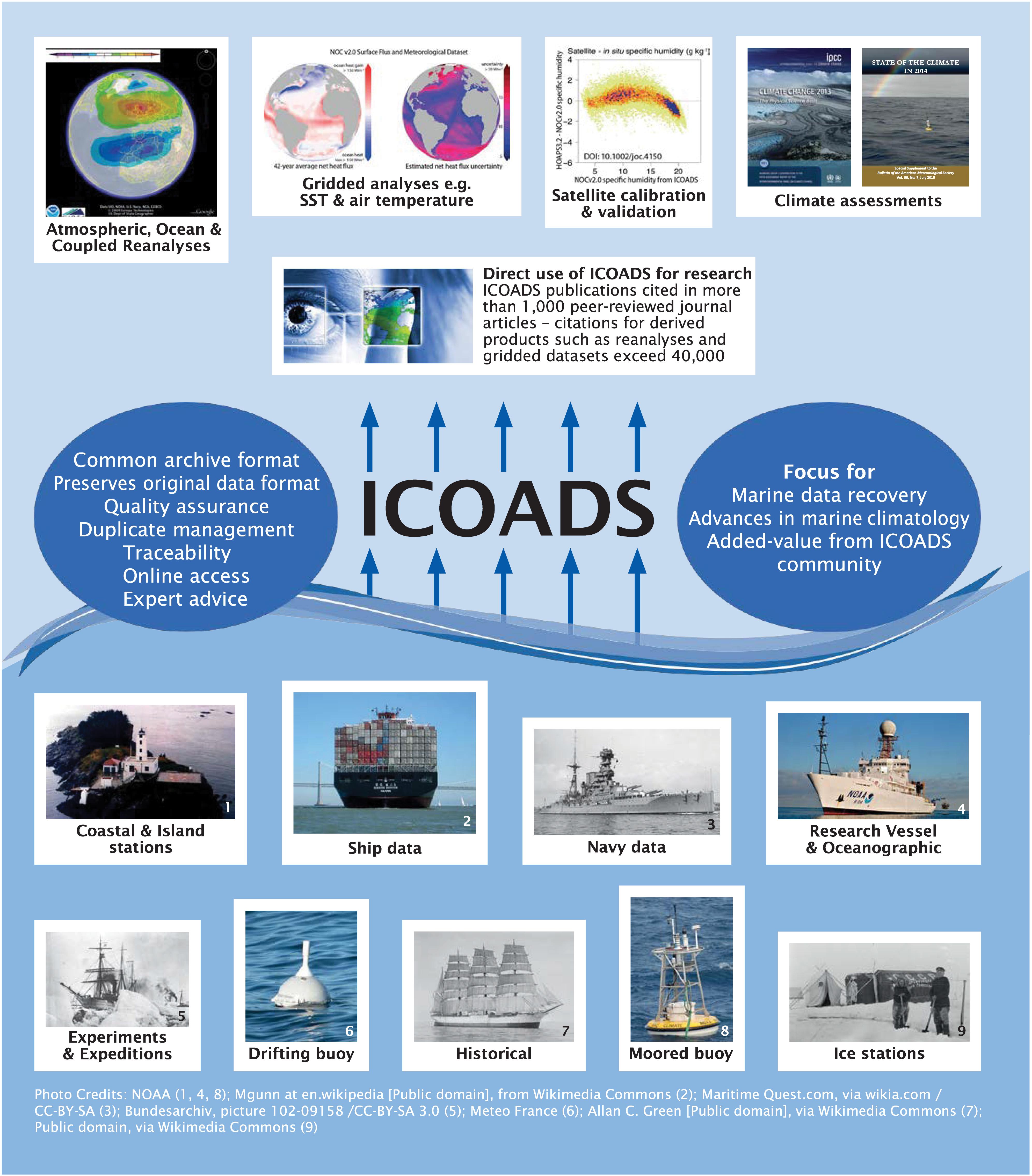
Figure 1. International Comprehensive Ocean-Atmosphere Data Set (ICOADS) processes data from many different platforms that feed into a wide variety of products.
The original COADS was released in 1985 (Slutz et al., 1985) providing open access to individual reports from the surface marine climate record for the first time. Observations include a range of surface Essential Climate Variables (ECVs) and Essential Ocean Variables (EOVs) (Bojinski et al., 2014) from ships, moored and drifting buoys, fixed platforms and other types of measurement platforms. These individual observations underpin gridded monthly climate summary statistics for sea surface temperature (SST), air temperature, humidity, sea level pressure, wind speed and components, and cloud cover. These statistics are produced at 2° and 1° spatial resolution dating back to 1800 and 1960, respectively. The ICOADS summaries have been superseded for most applications by more sophisticated products offering improvements in quality control (QC), treatment of uncertainty, bias adjustment, or statistical infilling of unobserved regions or periods, for specific variables. Such products are the foundation of climate monitoring, for example providing the marine component of estimates of Global Mean Surface Temperature (GMST) that defines the ambition of the UN Framework Convention on Climate Change (UNFCCC) and the resulting Paris Agreement to prevent dangerous climate change (e.g., Huang et al., 2017; Kent et al., 2019). These products are based on ICOADS individual observations because they provide traceable access to data in a uniform format regardless of its source.
The ICOADS has evolved from a United States-centric effort to an international collaboration, emphasizing the ‘I’ in ICOADS. Since 2014, developments have been guided in partnership between the United States National Oceanic and Atmospheric Administration’s (NOAA) National Centers for Environmental Information (NCEI), the National Center for Atmospheric Research (NCAR), the Florida State University (FSU), and internationally with organizations including Deutscher Wetterdienst (DWD, Germany), the National Oceanography Centre (NOC, United Kingdom) and the Met Office (United Kingdom). NOAA/NCEI have responsibility for the day-to-day operation and maintenance of ICOADS and provide basic data access and periodic full updates. NCAR provides enhanced access to ICOADS that supports data subsetting and alternative data formats and provides access to “value-added” data products and metadata. The other partners provide expertise to ICOADS, access to new observations, and ad hoc support, e.g., with testing, answering user questions, and documentation.
Since 2017 the European Union Copernicus Climate Change Service has provided funding for the modernization of processing systems for marine climate data (C3S 311a Lot 2: Access to observations from global climate data archives1). This has allowed ICOADS partners (NOC and the Met Office) to develop new systems for QC, harmonize and extend metadata and improve duplicate identification for ICOADS observations. In partnership with this activity NCEI have committed to incorporate these improved systems into their ICOADS processing system, requiring a major update to their current processing capability.
The ICOADS was created as an archive focusing on those parameters typically measured by Voluntary Observing Ships (VOS, Smith et al., 2019), and includes only observations made near the surface and contains very limited reports of biogeochemical parameters. Typical sampling intervals depend on the observing platform type and range from hourly to daily. Satellite measurements are outside the scope of ICOADS. The archive has expanded in the past to include measurements using new platform and sensor technologies, and observations at higher frequencies, e.g., 10 or more reports per hour. However, the extent to which ICOADS has the capability to incorporate new types and higher data volumes, emerging or planned, is presently unclear.
Since inception, ICOADS has been shaped and developed by the user community, including through a series of workshops on Advances in Marine Climatology (CLIMAR; JCOMM, 2015) and on the Advances in the Use of Historical Marine Climate Data (MARCDAT; JCOMM, 2016). The fifth session of the CLIMAR series (CLIMAR-5) was hosted by DWD in Hamburg, Germany in May 2019 and discussed and further developed community needs and requirements prior to OceanObs’19.
A Foundational Database
The ICOADS provides access to an archive of surface marine measurements of ECVs and EOVs stretching back to the earliest observations in the late 17th century and have been updated to include data for the latest complete month. ICOADS provides data from a range of different platform types, initially dominated by reports from ships, but now representing a diverse range including different types of buoys, fixed platforms and profilers. Unlike archives for land data that have often separated data by parameter (Thorne et al., 2018), ICOADS has kept multivariate reports together, storing any parameters or metadata that could not be accommodated in the main record in a data supplement.
In addition to the general community of scientists, the primary user groups for ICOADS include dataset developers, reanalysis centers, and the satellite community. Through its use in many data products [e.g., HadSST3 (Kennedy et al., 2011), HadISST (Rayner et al., 2003), ERSSTv5 (Huang et al., 2017), COBE-SST2 (Hirahara et al., 2014), HadNMAT2 (Kent et al., 2013), HadCRUT4 (Morice et al., 2012), MLOST (Vose et al., 2012), NOAAGlobalTemp (Zhang et al., 2019), GISTEMP (Hansen et al., 2010), WASWind (Tokinaga and Xie, 2011), NOCv2.0 (Berry and Kent, 2009), and HadCRUH (Willett et al., 2008)], and as input data sources for assimilation into atmospheric, oceanic and coupled reanalyses [e.g., The 20th Century Reanalysis (Compo et al., 2011), ERA-Interim (Dee et al., 2011), NCEP CFSR (Saha et al., 2010), SODA (Carton and Giese, 2008), and MERRA (Rienecker et al., 2011)] the impact of ICOADS is greatly amplified. Journal citations for these indirect user groups exceeded 8000 in 2017. Satellite applications include the iQuam in situ SST quality monitor (Xu and Ignatov, 2014), evaluation of heat flux products (Prytherch et al., 2015; Kinzel et al., 2016; Liman et al., 2018), and SST assessments (Berry et al., 2018; Tsamalis and Saunders, 2018).
Climate change monitoring and assessment (e.g., Intergovernmental Panel on Climate Change [IPCC], 2013), the State of the Climate report (Blunden and Arndt, 2018), the World Meteorological Organization (WMO) Statement on the State of the Global Climate 2017 (World Meteorological Organization [WMO], 2018) all require climate data records to be updated, typically with the latest complete month or year. ICOADS therefore produces monthly updates based on near real time (NRT) data from the Global Telecommunications System (GTS) to support such users. The current version is R3.0.1, covering 2015 to the present.
Periodically, ICOADS produces new major releases (Slutz et al., 1985; Woodruff et al., 1993, 1998, 2011; Worley et al., 2005; Freeman et al., 2017) which ingest new or improved data sources, update data formats or processing methodology, and may replace some NRT observations with data from selected delayed mode archives. Every ICOADS release has ingested newly available marine observations from data rescue activities and R3.0 saw new data from citizen science initiatives (Old Weather, Weather Detective), the atmospheric circulation reconstructions over the Earth initiative (ACRE, Allan et al., 2011), and from DWD, NCEI, the Australian Bureau of Meteorology, Woods Hole Oceanographic Institute, and Environment Canada. Data from delayed mode archives were updated, including from the world ocean database 2013 (WOD; Boyer et al., 2013); the Global Ocean Surface Underway Data (GOSUD) Project; buoy measurements from the Global Tropical Moored Buoy Array (McPhaden et al., 1998, 2009; Bourlès et al., 2008) and the Canadian Oceanography and Scientific Data archive; and research vessel observations from the Shipboard Automated Meteorological and Oceanographic System (SAMOS) initiative (Smith et al., 2009, 2018). Significant extensions to data formats included a report-level “unique identifier” to support applications with requirements for detailed provenance, and new depth referenced oceanographic data including seawater temperature, salinity, nutrients, oxygen, and dissolved carbon elements from the WOD (Boyer et al., 2013).
Data Access and Services
International Comprehensive Ocean-Atmosphere Data Set data products are available from NCEI/NOAA, ESRL/PSD/NOAA and NCAR2. NCAR provides access to the products in the native production ASCII International Marine Meteorological Archive (IMMA) format, for individual observations (Smith et al., 2016). This basic access is extended with user interfaces that drive spatial, temporal, and parameter selection data subsetting services, and output formats are provided in tabular and comma-separated-value (CSV) ASCII. Subsetting has numerous additional features that allow users to customize output products, taking advantage of the extensive content in the IMMA format and ICOADS Value-added Database (IVAD). Users are able to select standard or customized QC levels, choose individual parameters and metadata, and receive a full data record provenance in the output. IVAD also has the unique capability to collect feedback from users and to produce a rich history of the observations through the data lifecycle. First, adjusted data values produced and documented by community experts to address sampling and instrumentation biases are provided as supplemental attachments to the core observation records. Second, assimilation feedback information from climate reanalysis projects can be stored in IVAD and includes parameters such as model bias corrections, first-guess values, and QC flags. Both of these elements are provided in the full IMMA records and can also be selected in the subsetting service supported at NCAR.
On-Going Work and Future Requirements
Marine archives rely on observations transmitted in NRT, typically in support of weather forecasting operations. Whilst many national weather prediction centers maintain their own collections of such observations, as there is no formal international system for the archival of and free access to these data. ICOADS has implicitly fulfilled this role for surface marine data, but this is a major task, even for the data types currently supported. A major focus for ICOADS since the production of R3.0.0 (Research Data Archive et al., 2016) has been the transition to the Binary Universal Form for the Representation of Meteorological Data (BUFR) format, used for real-time transmissions on the GTS. A stand-alone dataset of decoded binary format reports for buoys and ships now exists and will be incorporated into a new NRT product in the future, when all format translations are fully validated.
The ICOADS serves users who need access to a broad and diverse range of surface marine observations and takes advantage of the co-location of several ECVs and EOVs with extensive platform and observational metadata. This unified access means that most climate data products are constructed from the same extensive archive, thus any differences between products can be attributed to methodological differences rather than unknown differences in observational input. For users requiring strong data provenance, this is essential, and it also has the advantage of promoting the sharing of information about issues with the data, or exchange of information about processing applied at the report level, including through the construction of formal IVAD additions to the ICOADS record. For ICOADS to continue to serve as the sole or main data source for a wide range of data products it must remain as complete as possible within its defined scope, be reliably and conveniently available, and fully traceable.
One measure of the value of ICOADS is the frequency of calls for it to include a wider range of variables and additional platform types. Fulfilling the needs of users requesting faster access to NRT data, more frequent full releases, and a wider range of variables and data sources requires a solid, resource-backed commitment. The ability to fulfill these requests is unachievable without sufficient resources for ICOADS and the provision of dedicated, internationally integrated data management systems that can feed marine data into ICOADS.
The ICOADS serves as the archive for the output of marine digitization activities. Producers of long-term reanalyses (e.g., Compo et al., 2011; Poli et al., 2016) require these observations to be quickly incorporated into ICOADS and call for more frequent full release updates to support this facility. Annual or quarterly to semiannual updates have been recommended, and a defined update cycle will help dataset developers plan their own upgrades.
The ICOADS can only be as good as the data sources on which it relies. The decline in numbers, and coverage, of reports of ECVs, as shown in Figure 2, has been documented (Kent et al., 2006; Berry and Kent, 2017). This has been a particular problem for the production of long-term datasets of air temperature (Kent et al., 2013), humidity (Willett et al., 2008; Berry and Kent, 2009), clouds (Eastman et al., 2011), winds (Tokinaga and Xie, 2011) and waves (Grigorieva et al, 2017; see Kent et al. 2019 for more information). It is also restricting the development of satellite-derived datasets of parameters critical for estimation of surface heat flux (Kinzel et al., 2016; Liman et al., 2018; Cronin et al., 2019), a newly designated ECV (Global Climate Observing System [GCOS], 2016).
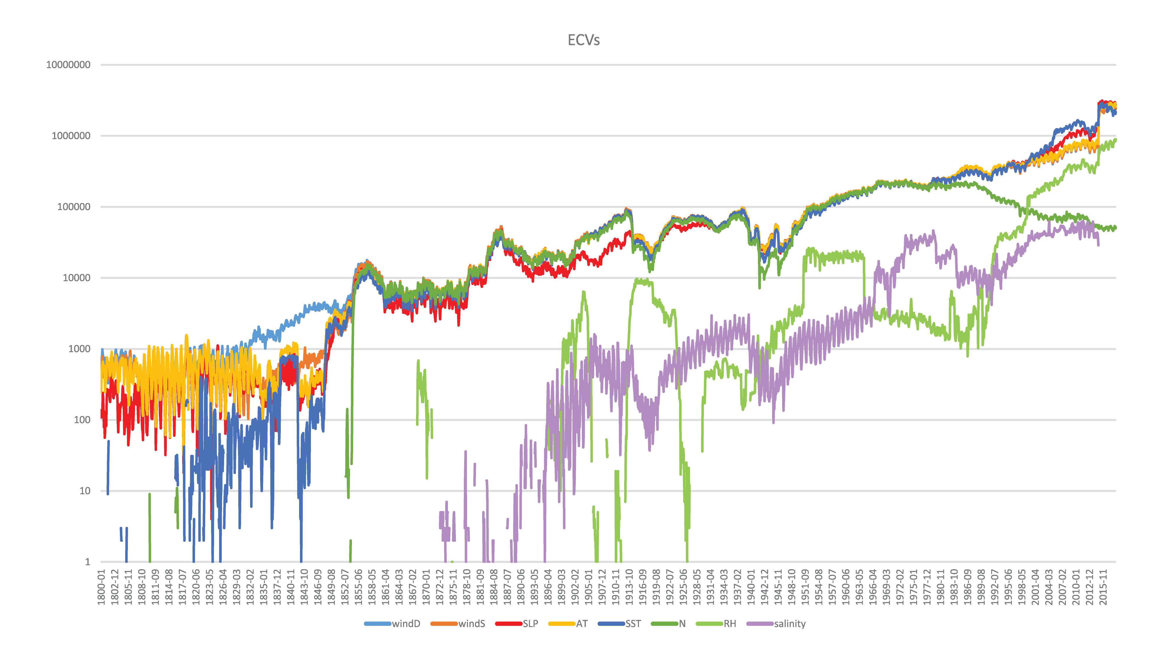
Figure 2. Essential Climate Variables (ECVs) in International Comprehensive Ocean-Atmosphere Data Set (ICOADS) R3.0.0 and R3.0.1 from January 1800 to September 2018: windD, wind direction; windS, wind speed; SLP, sea level pressure; AT, air temperature; SST, sea surface temperature; N, total cloud amount; RH, relative humidity; salinity, sea surface salinity. The y axis is in a log10 scale and shows the number of reports per month for those ECVs listed.Some elements are highly variable in their availability, especially in the early period of record. In the modern period there are noticeable decreases in ECVs, i.e., cloud observations and even SST. Some of these, i.e., clouds, are attributed to changes from manual observations to automated observation systems, where humans have not been replaced by sensors to continue observing the parameters.
The ICOADS incorporates several delayed mode archives, but each requires extensive processing to conform to the ICOADS data formats. A further task is the identification of data matches between NRT and delayed mode versions of the same original reports, a task made difficult by changes in data format between sources and the lack of unique identifiers to cleanly identify and flag different versions of the same original data.
Extension of ICOADS to new data types (e.g., Autonomous Surface Vehicles, ASVs), or to a wider range of oceanographic data types, will need to be supported by dedicated data management systems for those specific data types. Each different type of data source requires a data system designed for its needs with evaluation by experts. New data systems will need to be compliant with WMO Integrated Global Observing System (WIGOS) technical regulations3. Recent work at NCEI, to enable translation of BUFR codes for ICOADS, will need to be extended and the IMMA format used by ICOADS will require updating to align with the new standards more closely.
There also have been calls for a full reprocessing of the ICOADS archive (e.g., Kent et al., 2017). The early releases of ICOADS (Woodruff et al., 1987, 1993, 1998; Worley et al., 2005) did not retain observations thought to be inferior duplicates through the processing system. These data, up to a third of the total, are only available in deprecated data formats. Recovery of these data will provide information on uncertainty due to different data processing paths and provide examples and training data for the identification of inexact duplicates. This will enable improved duplicate flagging within ICOADS, and permit users to develop their own schemes. Recovery and reprocessing of existing ICOADS sources will also facilitate the enhancement of ICOADS platform metadata through ship tracking (Carella et al., 2017), needed for advanced approaches to uncertainty estimation (Kennedy, 2014; Kent et al., 2017).
In order for ICOADS to remain the central repository for surface in situ marine data, many updates are needed in order to modernize the source data, the underlying processing system, and to better address community needs in an efficient and timely manner. ICOADS will engage users directly through workshops and user surveys, as well as coordinate tasks with international partners and programs, leveraging existing expertise and resources. To do this, a solid foundation is needed at the hosting center, including a dedicated team tasked specifically to these duties. The following recommendations have been proposed, and where possible are being acted upon. A complete modernization, building on current features, is overdue. OceanObs’19 provides a large venue to gain a broader perspective of the needs of the marine community, setting the groundwork to expand on and include new community recommendations. ICOADS is committed to meeting users’ needs and plan to incorporate the following recommendations with the guidance of partners, data set users, and the OceanObs’19 community.
Recommendations
Maintain the Best Features of the Present ICOADS Data System
Continue to provide open and free access to the most complete archive of surface marine observations, with NRT updates and periodic ingestion of new observations.
Continue to support users with traceable and reproducible data, including for custom subsets that can be formally cited in publications.
Continue to work closely with the marine data rescue community in acting as the principle archive for newly digitized or recovered surface marine observations, ensuring that ICOADS adapt to capture and make accessible diverse information from historical digitization.
Modernization of ICOADS
The ICOADS data systems require modernization to align with current international format and metadata standards more closely, such as WIGOS. This will enable efficient future ingestion of WIGOS-compliant data sources, especially in NRT BUFR streams.
The ICOADS processing needs to be restructured into a modular system to easily allow the development and testing of new code, to integrate improved software from external sources such as Copernicus C3S 311a. ICOADS has always been open source, but now requires a modern code management system that supports community code development.
Improved approaches to QC and duplicate identification should be implemented along with flexible access to data with different levels of QC flagging.
Support user needs for higher levels of traceability, for example linking rescued data directly to logbook images.
Review all data sources, including original inputs to early releases, and the available delayed mode archives and NRT streams to ensure that ICOADS is based on the best data sources.
Facilitate community involvement in reprocessing in addition to data rescue efforts.
Improve the completeness of ICOADS documentation and provide simpler access to the wide variety of supporting information underlying that documentation. Continue to work with the data rescue community to digitize documentation and metadata for existing data sources.
Improving Integration of ICOADS With International Data Systems
Formalizing ICOADS Internationally: Fulfill role as Centre for Marine-Meteorological and Oceanographic Climate Data (CMOC) in the JCOMM Marine Climate Data System (MCDS) (see World Meteorological Organization [WMO] (2017a,b); Pinardi et al. (2019) for more information on the JCOMM MCDS). By serving in this capacity, ICOADS will integrate more formally with international data systems and provide enhancements to global data management and quality.
Improve resilience of ICOADS data, processes, and documentation by providing automated mirroring at ICOADS partner sites in order to avoid disruptions of service and to provide backups in case of technological failure and unexpected down time of ICOADS main operational systems hosted at NCEI. Mirroring will also satisfy a CMOC requirement when operating in the MCDS international data management system.
Improve collaboration with experts providing access to delayed mode data archives to provide this enhanced data more efficiently to ICOADS users. Work to ensure that all contributions to ICOADS are explicitly recognized in data citations.
Requirements for Enhancements to Global Data Management Systems
Establish centers responsible for the secure archival of NRT marine observations from the GTS in their native formats.
Building on the successful examples, such as the Argo Data System (ASVs)4, establish international data centers for all marine observation types including for ASVs to ensure that all new data types are managed by domain experts and can be efficiently integrated into more general archives such as ICOADS.
Work with data providers to establish the inclusion of originators unique identification tags with all marine observations to enable the efficient linking of reports derived from the same original observation.
Author Contributions
CL, EK, and LG developed and contributed the figures. All authors contributed to writing sections of the manuscript and each read and approved its final version.
Funding
SS was funded by a cooperative agreement (NA16OAR4320199) from the Climate Program Office, Ocean Observing and Monitoring Division of the National Oceanic and Atmospheric Administration (FundRef#100007298) via a subaward (191001.363513.01D) from the Northern Gulf of Mexico Cooperative Institute administered by the Mississippi State University. NCEI was partially funded by NOAA CPO/OOMD for ICOADS development. EK was funded by NERC under the CLASS program (NE/R015953/1).
Conflict of Interest Statement
EF and CL were employed by the Riverside Technology, Inc., as contractors for the NCEI.
The remaining authors declare that the research was conducted in the absence of any commercial or financial relationships that could be construed as a potential conflict of interest.
Acknowledgments
We are grateful to all the contributors (e.g., who have contributed data, ideas, etc.), developers, organizations which provided funding and in-kind support, and most importantly, our users. We also thank the reviewers and the editors at Frontiers and the OceanObs’19 organizers for their assistance in coordinating and publishing the Community White Papers.
Footnotes
- ^ https://climate.copernicus.eu/node/562
- ^ http://icoads.noaa.gov/products.html
- ^ http://www.wmo.int/pages/prog/www/wigos/WRM.html
- ^ www.argodatamgt.org
References
Allan, R., Brohan, P., Compo, G. P., Stone, R., Luterbacher, J., and Brönnimann, S. (2011). The international atmospheric circulation reconstructions over the earth (ACRE) initiative. Bull. Am. Meteorol. Soc. 92, 1421–1425. doi: 10.1175/2011BAMS3218.1
Berry, D. I., Corlett, G., Embury, O., and Merchant, C. (2018). Stability assessment of the (A)ATSR sea surface temperature climate dataset from the european space agency climate change initiative. Remote Sens. 10:126. doi: 10.3390/rs10010126
Berry, D. I., and Kent, E. C. (2009). A new air-sea interaction gridded dataset from ICOADS with uncertainty estimates. Bull. Am. Meteorol. Soc. 90, 645–656. doi: 10.1175/2008BAMS2639.1
Berry, D. I., and Kent, E. C. (2017). Assessing the health of the global surface marine climate observing system. Int. J. Climatol. 37, 2248–2259. doi: 10.1002/joc.4914
Blunden, J., and Arndt, D. S. (eds) (2018). State of the climate in 2017. Bull. Am. Meteorol. Soc. 99, Si–S332. doi: 10.1175/2018BAMSStateoftheClimate.1
Bojinski, S., Verstraete, M., Peterson, T. C., Richter, C., Simmons, A., and Zemp, M. (2014). The concept of essential climate variables in support of climate research, applications, and policy. . Bull. Am. Meterol. Soc. 95, 1431–1443. doi: 10.1175/BAMS-D-13-00047.1
Bourlès, B., Lumpkin, R., McPhaden, M. J., Hernandez, F., Nobre, P., Campos, E., et al. (2008). The PIRATA program: history, accomplishments, and future directions. Bull. Am. Meteorol. Soc. 89, 1111–1125. doi: 10.1175/2008BAMS2462.1
Boyer, T. P., Antonov, J. I., Baranova, O. K., Coleman, C., Garcia, H. E., Grodsky, A., et al. (2013). World Ocean database 2013, eds S. Levitus and A. Mishonov (Silver Spring, MD: NOAA Atlas NESDIS), 209. doi: 10.7289/V5NZ85MT
Carella, G., Kent, E. C., and Berry, D. I. (2017). A probabilistic approach to ship voyage reconstruction in ICOADS. Int. J. Climatol. 37, 2233–2247. doi: 10.1002/joc.4492
Carton, J. A., and Giese, B. S. (2008). A reanalysis of ocean climate using simple ocean data assimilation (SODA). Mon. Wea. Rev. 136, 2999–3017. doi: 10.1175/2007MWR1978.1
Compo, G. P., Whitaker, J. S., Sardeshmukh, P. D., Matsui, N., Allan, R. J., Yin, X., et al. (2011). The twentieth century reanalysis project. Q. J. R. Meteorol. Soc. 137, 1–28. doi: 10.1002/qj.776
Cronin, M. F., Gentemann, C. L., Edson, J. B., Ueki, I., Bourassa, M., Brown, S., et al. (2019). Air-sea fluxes with a focus on heat and momentum. Front. Mar. Sci. doi: 10.3389/fmars.2019.00430
Dee, D. P., Uppala, S. M., Simmons, A. J., Berrisford, P., Poli, P., Kobayashi, S., et al. (2011). The ERA-Interim reanalýsis: configuration and performance of the data assimilation system. Q. J. R. Meteorol. Soc. 137, 553–597. doi: 10.1002/qj.828
Eastman, R., Warren, S. G., and Hahn, C. J. (2011). Variations in cloud cover and cloud types over the ocean from surface observations, 1954–2008. J. Clim. 24, 5914–5934. doi: 10.1175/2011JCLI3972.1
Freeman, E., Woodruff, S. D., Worley, S. J., Lubker, S. J., Kent, E. C., Angel, W. E., et al. (2017). ICOADS Release 3.0: a major update to the historical marine climate record. Int. J. Climatol. 37, 2211–2232. doi: 10.1002/joc.4775
Global Climate Observing System [GCOS] (2016). The Global Observing System for Climate: Implementation Needs. GCOS-200 (GOOS-214). Geneva: World Meteorological Organization.
Grigorieva, V. G., Gulev, S. K., and Gavrikov, A. V. (2017). Global historical archive of wind waves based on voluntary observing ship data. Oceanology 57, 229–231. doi: 10.1134/S0001437017020060
Hansen, J., Ruedy, R., Sato, M., and Lo, K. (2010). Global surface temperature change. Rev. Geophys. 48:RG4004. doi: 10.1029/2010RG000345
Hirahara, S., Ishii, M., and Fukuda, Y. (2014). Centennial-scale sea surface temperature analysis and its uncertainty. J Clim. 27, 57–75. doi: 10.1175/JCLI-D-12-00837.1
Huang, B., Thorne, P. W., Banzon, V. F., Boyer, T., Chepurin, G., Lawrimore, J. H., et al. (2017). Extended reconstructed sea surface temperature, version 5 (ERSSTv5): upgrades, validations, and intercomparisons. J. Clim. 30, 8179–8205. doi: 10.1175/JCLI-D-16-0836.1
Intergovernmental Panel on Climate Change [IPCC] (2013). Climate change 2013: the physical science basis. in Contribution of Working Group I to the Fifth Assessment Report of the Intergovernmental Panel on Climate Change, eds T. F. Stocker, D. Qin, G.-K. Plattner, M. Tignor, S. K. Allen, J. Boschung, et al. (Cambridge: Cambridge University Press), 1535. doi: 10.1017/CBO9781107415324
JCOMM (2015). Proceedings of the Fourth JCOMM Workshop on Advances in Marine Climatology (CLIMAR-4) and of the First ICOADS Value-Added Database(IVAD-1) Workshop JCOMM Technical Report No. 79. Asheville, NC: JCOMM.
JCOMM (2016). Fourth International Workshop on Advances in the Use of Historical Marine Climate Data (MARCDAT-4) JCOMM Technical Report No. 131. JCOMM: Southampton UK.
Kennedy, J. J. (2014). A review of uncertainty in in situ measurements and data sets of sea surface temperature. Rev. Geophys. 52, 1–32. doi: 10.1002/2013RG000434
Kennedy, J. J., Rayner, N. A., Atkinson, C. P., and Killick, R. E. (2019). An ensemble data set of sea-surface temperature change from 1850: the Met Office Hadley Centre HadSST.4.0.0.0 data set. J. Geophys. Res. Atmos. 124. doi: 10.1029/2018JD029867
Kent, E. C., Berry, D. I., Woodruff, S. D., and Taylor, P. K. (2006). Voluntary observing ships: a vital observing system in decline. Clivar Exchanges 11, 20–21.
Kent, E. C., Kennedy, J. J., Smith, T. M., Hirahara, S., Huang, B., Kaplan, A., et al. (2017). A call for new approaches to quantifying biases in observations of sea-surface temperature. BAMS 98, 1601–1616. doi: 10.1175/BAMS-D-15-00251.1
Kent, E. C., Rayner, N. A., Berry, D. I., Eastman, R., Grigorieva, V., Huang, B., et al. (2019). Observing requirements for long-term climate records at the ocean surface. Front. Mar. Sci. doi: 10.3389/fmars.2019.00441
Kent, E. C., Rayner, N. A., Berry, D. I., Saunby, M., Moat, B. I., Kennedy, J. J., et al. (2013). Global analysis of night marine air temperature and its uncertainty since 1880: the HadNMAT2 data set. J. Geophys. Res. 118, 1281–1298. doi: 10.1002/jgrd.50152
Kinzel, J., Fennig, K., Schröder, M., Andersson, A., Bumke, K., and Hollmann, R. (2016). Decomposition of random errors inherent to HOAPS-3.2 near-surface humidity estimates using multiple triple collocation analysis. J. Atmos. Oceanic Technol 33, 1455–1471. doi: 10.1175/JTECH-D-15-0122.1
Liman, J., Schröder, M., Fennig, K., Andersson, A., and Hollmann, R. (2018). Uncertainty characterization of HOAPS 3.3 latent heat-flux-related parameters. Atmos. Meas. Tech. 11, 1793–1815. doi: 10.5194/amt-11-1793-2018
McPhaden, M. J., Busalacchi, A. J., Cheney, R., Donguy, J. R., Gage, K. S., Halpern, D., et al. (1998). The tropical ocean-global atmosphere (TOGA) observing system: a decade of progress. J. Geophys. Res. 103, 14169–14240. doi: 10.1029/97JC02906
McPhaden, M. J., Meyers, G., Ando, K., Masumoto, Y., Murty, V. S. N., Ravichandran, M., et al. (2009). RAMA: the research moored array for African–Asian–Australian monsoon analysis and prediction. Bull. Am. Meteorol. Soc. 90, 459–480. doi: 10.1175/2008BAMS2608.1
Morice, C. P., Kennedy, J. J., Rayner, N. A., and Jones, P. D. (2012). Quantifying uncertainties in global and regional temperature change using an ensemble of observational estimates: the HadCRUT4 dataset. J. Geophys. Res. 117:D08101. doi: 10.1029/2011JD017187
Pinardi, N., Stander, J., Legler, D., O’Brien, K., Boyer, T., Cuff, T., et al. (2019). The Joint IOC (of UNESCO) and WMO collaborative effort for met-ocean services. Front. Mar. Sci. doi: 10.3389/fmars.2019.00410
Poli, P., Hersbach, H., Dee, D. P., Berrisford, P., Simmons, A. J., Vitart, F., et al. (2016). ERA-20C: an atmospheric reanalysis of the Twentieth Century. J. Clim. 29, 4083–4097. doi: 10.1175/JCLI-D-15-0556.1
Prytherch, J., Kent, E. C., Fangohr, S., and Berry, D. I. (2015). A comparison of SSM/I-derived global marine surface specific humidity datasets. Int. J. Climatol. 35, 2359–2381. doi: 10.1002/joc.4150
Rayner, N. A., Parker, D. E., Horton, E. B., Folland, C. K., Alexander, L. V., Rowell, D. P., et al. (2003). Global analyses of sea surface temperature, sea ice, and night marine air temperature since the late nineteenth century. J. Geophys. Res. 108:4407. doi: 10.1029/2002JD002670
Research Data Archive, et al. (2016). International Comprehensive Ocean-Atmosphere Data Set (ICOADS) Release 3, Individual Observations. Research Data Archive at the National Center for Atmospheric Research, Computational and Information Systems Laboratory. Boulder, CO: National Center for Atmospheric Research, doi: 10.5065/D6ZS2TR3
Rienecker, M. M., Suarez, M. J., Gelaro, R., Todling, R., Bacmeister, J., Liu, E., et al. (2011). MERRA: NASA’s modern-era retrospective analysis for research and applications. J. Clim. 24, 3624–3648. doi: 10.1175/JCLI-D-11-00015.1
Saha, S., Moorthi, S., Pan, H., Wu, X., Wang, J., Nadiga, S., et al. (2010). The NCEP climate forecast system reanalysis. Bull. Am. Meteor. Soc. 91, 1015–1058. doi: 10.1175/2010BAMS3001.1
Slutz, R. J., Lubker, S. J., Hiscox, J. D., Woodruff, S. D., Jenne, R. L., Joseph, R. H., et al. (1985). Comprehensive Ocean-Atmosphere Dataset: Release 1. NTIS PB86-105723. Boulder, CO: NOAA Environmental Research Laboratories, Climate Research Program, 268.
Smith, S. R., Alory, G., Andersson, A., Asher, W., Baker, A., Berry, D. I., et al. (2019). Ship-Based contributions to global ocean, weather, and climate observing systems. Front. Mar. Sci. doi: 10.3389/fmars.2019.00434
Smith, S. R., Briggs, K., Bourassa, M. A., Elya, J., and Paver, C. R. (2018). Shipboard automated meteorological and oceanographic system data archive: 2005–2017. Geosci. Data J. 5, 73–86. doi: 10.1002/gdj3.59
Smith, S. R., Freeman, E., Lubker, S. J., Woodruff, S. D., Worley, S. J., Angel, W. E., et al. (2016). The International Maritime Meteorological Archive (IMMA) Format. Available at: http://icoads.noaa.gov/e-doc/imma/R3.0-imma1.pdf (accessed February 28, 2019).
Smith, S. R., Rolph, J. J., Briggs, K., and Bourassa, M. A. (2009). Quality-Controlled Underway Oceanographic and Meteorological Data from the Center for Ocean-Atmospheric Predictions Center (COAPS) - Shipboard Automated Meteorological and Oceanographic System (SAMOS). Asheville, NC: NOAA National Centers for Environmental Information. Dataset, doi: 10.7289/V5QJ7F8R
Thorne, P. W., Allan, R. J., Ashcroft, L., Brohan, P., Dunn, R. J. H., Menne, M. J., et al. (2018). Toward an integrated set of surface meteorological observations for climate science and applications. Bull. Am. Meteorol. Soc. 98, 2689–2702. doi: 10.1175/BAMS-D-16-0165.1
Tokinaga, H., and Xie, S. (2011). Wave- and anemometer-based sea surface wind (WASWind) for climate change analysis. J. Clim. 24, 267–285. doi: 10.1175/2010JCLI3789.1
Tsamalis, C., and Saunders, R. (2018). Quality assessment of sea surface temperature from ATSRs of the climate change initiative (Phase 1). Remote Sens. 10:497. doi: 10.3390/rs10040497
Vose, R., Arndt, D., Banzon, V., Easterling, D., Gleason, B., Huang, B., et al. (2012). NOAA’S merged land–ocean surface temperature analysis. Bull. Am. Meteorol. Soc. 93, 1677–1685.
Willett, K. M., Jones, P. D., Gillett, N. P., and Thorne, P. W. (2008). Recent changes in surface humidity: development of the HadCRUH dataset. J. Clim. 21, 5364–5383. doi: 10.1175/2008JCLI2274.1
Woodruff, S. D., Diaz, H. F., Elms, J. D., and Worley, S. J. (1998). COADS Release 2 data and metadata enhancements for improvements of marine surface flux fields. Phys. Chem. Earth 23, 517–526. doi: 10.1016/S0079-1946(98)00064-0
Woodruff, S. D., Lubker, S. J., Wolter, K., Worley, S. J., and Elms, J. D. (1993). Comprehensive ocean–atmosphere data set (COADS) Release 1a: 1980–92. Earth Syst. Monit. 4, 1–8.
Woodruff, S. D., Slutz, R. J., Jenne, R. L., and Steurer, P. M. (1987). A comprehensive ocean-atmosphere data set. Bull. Am. Meteorol. Soc. 68, 1239–1250.
Woodruff, S. D., Worley, S. J., Lubker, S. J., Ji, Z., Freeman, J. E., Berry, D. I., et al. (2011). ICOADS Release 2.5: extensions and enhancements to the surface marine meteorological archive. Int. J. Climatol. 31, 951–967. doi: 10.1002/joc.2103
World Meteorological Organization [WMO] (2017a). WMO No. 471 - Guide on Marine Meteorological Services Global Aspects, Vol. I. Geneva: WMO.
World Meteorological Organization [WMO] (2017b). WMO No. 558 - Manual on Marine Meteorological Services Global Aspects, Vol. I. Geneva: WMO.
World Meteorological Organization [WMO] (2018). WMO Statement on the State of the Global Climate 2017, WMO No. 1212. Geneva: WMO.
Worley, S. J., Woodruff, S. D., Reynolds, R. W., Lubker, S. J., and Lott, N. (2005). ICOADS Release 2.1 data and products. Int. J. Climatol. 25, 823–842. doi: 10.1002/joc.1166
Xu, F., and Ignatov, A. (2014). In situ SST quality monitor (iQuam). J. Atmos. Oceanic Technol. 31, 164–180. doi: 10.1175/JTECH-D-13-00121.1
Keywords: surface, in situ, observations, marine meteorology, ocean, climate, data management
Citation: Freeman E, Kent EC, Brohan P, Cram T, Gates L, Huang B, Liu C, Smith SR, Worley SJ and Zhang H-M (2019) The International Comprehensive Ocean-Atmosphere Data Set – Meeting Users Needs and Future Priorities. Front. Mar. Sci. 6:435. doi: 10.3389/fmars.2019.00435
Received: 13 November 2018; Accepted: 05 July 2019;
Published: 23 July 2019.
Edited by:
Sabrina Speich, École Normale Supérieure, FranceReviewed by:
Fabien Roquet, University of Gothenburg, SwedenAntonio Navarra, Ca’ Foscari University of Venice, Italy
Wenju Cai, Centre for Southern Hemisphere Oceans Research (CSHOR), Australia
Copyright © 2019 Freeman, Kent, Brohan, Cram, Gates, Huang, Liu, Smith, Worley and Zhang. This is an open-access article distributed under the terms of the Creative Commons Attribution License (CC BY). The use, distribution or reproduction in other forums is permitted, provided the original author(s) and the copyright owner(s) are credited and that the original publication in this journal is cited, in accordance with accepted academic practice. No use, distribution or reproduction is permitted which does not comply with these terms.
*Correspondence: Eric Freeman, ZXJpYy5mcmVlbWFuQG5vYWEuZ292