 Emanuela Fanelli1,2*
 Silvia Bianchelli1
 Federica Foglini3
 Miquel Canals4
 Giorgio Castellan3Queralt Güell-Bujons4,5Bella Galil6Menachem Goren6
 Julian Evans7
 Marie-Claire Fabri8
 Sandrine Vaz9
 Tiziana Ciuffardi10
 Patrick J. Schembri7
 Lorenzo Angeletti3
 Marco Taviani2,3,11
 Roberto Danovaro1,2
- 1Department of Life and Environmental Sciences, Polytechnic University of Marche, Ancona, Italy
- 2Stazione Zoologica Anton Dohrn, Naples, Italy
- 3Institute of Marine Sciences, National Research Council (CNR-ISMAR), Bologna, Italy
- 4GRC Geociències Marines, Departament de Dinàmica de la Terrai de l’Oceà, Facultat de Ciències de la Terra, Universitat de Barcelona, Barcelona, Spain
- 5Department of Marine Biology and Oceanography, Institut de Ciències del Mar (ICM-CSIC), Barcelona, Spain
- 6The Steinhardt Museum of Natural History, Tel Aviv University, Tel Aviv-Yafo, Israel
- 7Department of Biology, University of Malta, Msida, Malta
- 8Ifremer, Centre de Méditerranée, La Seyne-sur-Mer, France
- 9MARBEC, Ifremer, CNRS, IRD, University of Montpellier, Sète, France
- 10Santa Teresa Marine Environment Research Centre, ENEA, La Spezia, Italy
- 11Woods Hole Oceanographic Institution, Woods Hole, MA, United States
Benthic habitats of the deep Mediterranean Sea and the biodiversity they host are increasingly jeopardized by increasing human pressures, both direct and indirect, which encompass fisheries, chemical and acoustic pollution, littering, oil and gas exploration and production and marine infrastructures (i.e., cable and pipeline laying), and bioprospecting. To this, is added the pervasive and growing effects of human-induced perturbations of the climate system. International frameworks provide foundations for the protection of deep-sea ecosystems, but the lack of standardized criteria for the identification of areas deserving protection, insufficient legislative instruments and poor implementation hinder an efficient set up in practical terms. Here, we discuss the international legal frameworks and management measures in relation to the status of habitats and key species in the deep Mediterranean Basin. By comparing the results of a multi-criteria decision analysis (MCDA) and of expert evaluation (EE), we identify priority deep-sea areas for conservation and select five criteria for the designation of future protected areas in the deep Mediterranean Sea. Our results indicate that areas (1) with high ecological relevance (e.g., hosting endemic and locally endangered species and rare habitats),(2) ensuring shelf-slope connectivity (e.g., submarine canyons), and (3) subject to current and foreseeable intense anthropogenic impacts, should be prioritized for conservation. The results presented here provide an ecosystem-based conservation strategy for designating priority areas for protection in the deep Mediterranean Sea.
Introduction
The deep sea (i.e., below 200-m depth) is the largest and least explored biome on Earth, with only <0.001% of its surface investigated in terms of biodiversity (Danovaro et al., 2014). Renewed research efforts on deep-sea ecosystems in the last decades have considerably improved our understanding of global ocean biodiversity, ecosystem functioning and the goods and services that these ecosystems provide (Danovaro et al., 2017). Deep-sea ecosystems are under increasing threat from human activities, due to industrial fisheries (especially bottom trawling), exploitation of hydrocarbons, waste dumping and littering, maritime traffic (sensu lato, i.e., as source of noise, oil spills and other pollutants, vector for non-indigenous species; Daly and White, 2021; Duarte et al., 2021), and other usages of the seabed, progressively expanding into deeper waters (Benn et al., 2010). Human impacts can act synergistically with other stressors in deep-sea ecosystems, whose resilience is still largely unknown (Mora et al., 2013). Therefore, effective conservation measures are urgently required for their protection before it is too late (Barbier et al., 2014; Danovaro et al., 2014, 2017). This is particularly true for the deep Mediterranean Sea, defined as “under siege” due to historical and current impacts of multiple stressors (Coll et al., 2012). While the basin is traditionally considered one of the most intensively investigated areas of the world in both terrestrial and coastal marine biodiversity, it lags other regions of the world in studies of its deep-sea fauna (Danovaro et al., 2010). However, the Mediterranean sea is a hot spot of biodiversity with a uniquely high percentage of endemic species (Myers et al., 2000), and despite its small dimensions (0.82% of the ocean surface), it hosts more than 7.5% of global biodiversity (Bianchi and Morri, 2000) with several unique and rare ecosystems occurring in its deeper part (Chimienti et al., 2020).
Given the insufficient knowledge of the occurrence, spatial extent and biodiversity of deep-sea habitats, a precautionary approach has been proposed for planned human activities in the deep sea (Durden et al., 2018). The main challenge to implementing a deep-sea geospatial approach is the lack of comprehensive biological and ecological data (Harris and Whiteway, 2009; Trebilco et al., 2011; Danovaro et al., 2020b), and adequate technology (Aguzzi et al., 2019). The lack of ecological baselines (Van Dover et al., 2012) requires the development of a global strategy based on essential ecological variables for deep-sea global monitoring (Smith et al., 2008; Danovaro et al., 2017, 2020b).
The setting up of deep-sea Marine Protected Areas (MPAs) and the creation of MPA networks are crucial for global ocean conservation. To achieve this, candidate areas for protection must be carefully chosen, considering conflicts of interest between MPAs, exploitation of natural resources and other usages of the maritime space.
The paucity of large-scale empirical knowledge on deep-sea systems implies the need of using models to define and plan conservation areas and associate measures. Some approaches have used resilience and recovery as criteria for the definition of areas deserving protection (Lotze et al., 2011; Lambert et al., 2014). The recovery capacity of a species/community can be an important variable for conservation and management measures (Lotze et al., 2011) and this is particularly true for deep-sea species, which usually show very low-turnover rates (see Rogers, 2015 and references cited therein). As an example, extremely slow growth rates and low dispersal capability were found for the zig-zag coral Madrepora oculata (Sabatier et al., 2012), one of the most widely distributed cold-water coral species of the Mediterranean basin, and for the bamboo coral Isidella elongata (14 mm/year: Andrews et al., 2009), once very common on muddy bottoms below 400 m of depth, pointing to very low resilience of these species. Various methodologies (e.g., Marxan, a decision support software for conservation planning) have been implemented and used to support the design of MPAs (McDonald-Madden et al., 2010; Combes and Vaz, 2019; Visalli et al., 2020), including Multi Criteria Decision Analysis (MCDA, see Melià, 2017, for a review of MCDA application for MPA design and management).
In the present study, we: (i) analyze the existing international framework and protection measures for the deep Mediterranean Sea, (ii) elaborate a MCDA, and (iii) conduct an Expert Evaluation (EE) survey to identify deep-sea areas deserving priority protection. We propose here five criteria for identifying priority areas for conservation in the deep Mediterranean Sea, together with a set of protection guidelines.
Protection Measures in the Deep Sea and the Mediterranean Context
On a global scale, spatial and adaptive management tools, specific research programs and ad hoc protection measures have been enforced for few Areas Beyond National Jurisdiction (ABNJ) (Ban et al., 2014), including the closure to bottom fisheries of some areas in the high seas by Regional Fisheries Management Organizations (RFMOs) (Taranto et al., 2012, see Supplementary Table 1 for a complete review).
Several initiatives for VMES’s protection include the work carried out by the RFMOs in charge of managing fisheries in the Antarctic area (CCAMLR, 2009) or in the South Pacific Ocean (SPRFMO: Parker et al., 2009). At global scale, different approaches have been proposed to protect deep-sea areas, mostly focused on the protection of deep-sea corals (Lumsden et al., 2007; Williams et al., 2020) or seamounts, being latter highly exploited by deep-sea fisheries (Clark and Dunn, 2012). These initiatives, which are welcome, fall short of fully adopting an ecosystem-based management of deep-sea ecosystems, with very few exceptions (Ardron et al., 2014). Worse yet, too often they lack enforcement and control, e.g., of the 12.4% of EU waters within the 200 NM boundary designated as MPAs, only 1.8% have a management plan (WWF, 2019), yet only 9.68% of the Mediterranean Sea has been designated for protection, with only 1.27% effectively protected (Gomei et al., 2019).
Approximately 80% of the Mediterranean Basin lies in waters deeper than 200 m, hosting a large variety of habitats and biodiversity hot spots (e.g., ca. 500 submarine canyons, ca. 100 seamounts, deep-water coral systems, cold seeps, carbonate mounds, mud volcanoes, brine pools, hydrothermal vents, anoxic systems, open slopes, and deep basins; Danovaro et al., 2010). In 2005, dredging and trawling at depths >1,000 m were banned (Rec. GFCM/29/2005/1), protecting from fishery ca. 59% of the deep Mediterranean Basin (1,632,507 km2; Rodríguez-Rodríguez et al., 2016; Manea et al., 2020). Some areas shallower than 1,000 m have been declared Fishery Restricted Areas (FRAs), enabling the protection of Vulnerable Marine Ecosystems (VMEs) or the preservation of Essential Fish Habitats (EFHs) for commercial species (Table 1). These protection measures were defined following different criteria, including the uniqueness, rarity and special importance for life history stages of exploited species, and the importance for threatened, endangered or declining species and/or habitats (UNEP-MAP-RAC/SPA, 2010a). Still, the unique VMEs found in the Mediterranean Sea are frequently associated with high levels of biodiversity, and provide habitat for very specific assemblages of species, including commercial species such as the European hake Merluccius merluccius, the Norway lobster, Nephrops norvegicus, and red shrimps Aristeus antennatus and Aristaeomorpha foliacea (i.e., the case of Isidella elongata facies, Carbonara et al., 2020). At the same time, these are highly vulnerable to the impacts of bottom fishing activities, and thus required specific management and conservation measures for their protection. Some noticeable efforts in this sense were made through European projects such as MEDISEH (Giannoulaki et al., 2013) or MarCons (Katsanevakis et al., 2020).
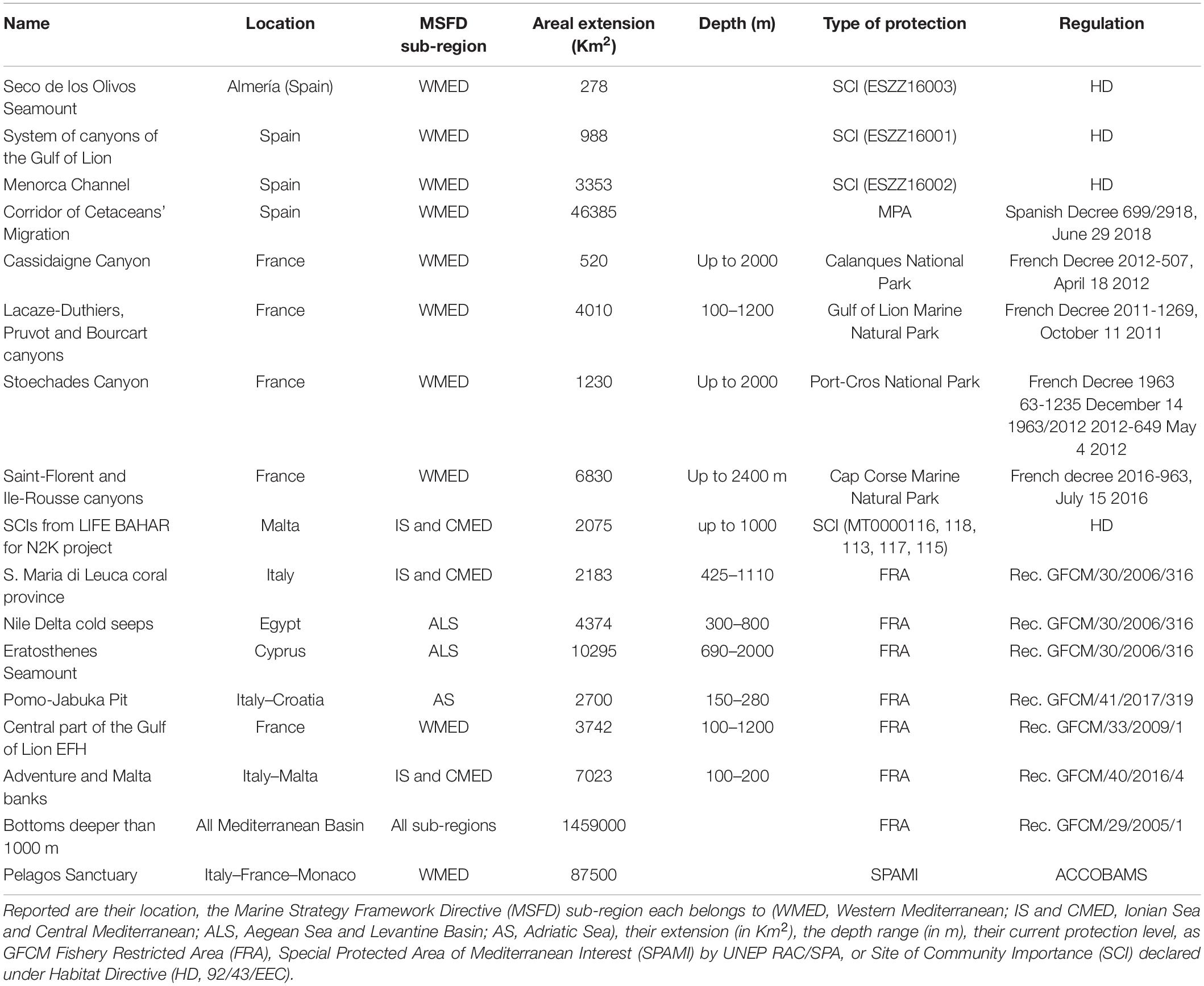
Table 1. List of protected areas in the deep Mediterranean Sea.
Sites of Community Importance (SCIs) have been recently established in Spanish and Maltese Mediterranean deep-sea areas under the EU’s Habitats Directive through EU-funded LIFE projects1,2 (Table 1). However, the marine component of Natura 2000, a European network of areas for the conservation of biodiversity, is still far from being representative of deep marine ecosystems (Katsanevakis et al., 2020). Eleven priority conservation areas covering ca. 20% of the Mediterranean Sea (UNEP-MAP-RAC/SPA, 2010b) have been selected as EBSAs by the CBD Contracting Parties based on scientific criteria (Annex I to COP 9, Decision XI/20). These areas include deep-sea regions and “special areas in the ocean that serve important purposes… to support the healthy functioning of oceans and the many services that it provides.” Mediterranean EBSAs are priority areas for: (i) cetacean conservation under ACCOBAMS3; (ii) deep-sea demersal and pelagic fisheries conservation (UNEP/MAP-RAC/SPA); and (iii) undersea features (i.e., seamounts, canyons, trenches, and mud volcanoes) (Piante and Ody, 2015). However, the institution of FRAs, SCIs, and EBSAs does not mandate enforcement or real protection and does not prevent the exploration and production of oil and gas (E&P) or mineral resources (Danovaro et al., 2020b). In fact, both the Nile Delta cold seeps and the Eratosthenes Seamount FRAs (Table 1) are set in active E&P zones.
European Directives 94/22/EC and 2013/30/EU established the rules for the exploitation of abiotic resources (even though the extraction of mineral resources is incompatible with a protected area corresponding to the IUCN Protected Area Management Categories I – IV; Ratner, 2016), but up to now no protection measures have been implemented in the deep sea.
The European Marine Strategy Framework Directive (MSFD, 2008/56/EC) applies for the first time an ecosystem-based approach for the preservation of marine ecosystems, but its application has been almost exclusively confined to coastal waters. Recent attempts to implement the MSFD in the deep sea have emphasized the importance of the bi-directional links between shallow and deep ecosystems (Danovaro et al., 2020a). In addition, the MSFD is so far binding only for EU MS, leaving most of the Mediterranean Sea without coordinated and comprehensive monitoring efforts.
Within the MSFD, some deep-sea species (deep-diving toothed cetaceans, deep-water fishes, and cephalopods) and habitats are theoretically included (see Comm. Dec. 848/2017, EU, 2017), but the MSFD is not clearly implemented except, partly, for Descriptor 1 (Biological diversity). As regards deep-sea habitats, Comm. Dec. 848/2017 simply mentions the generic bottom-types upper and lower bathyal rocks and biogenic reefs, and upper and lower bathyal and abyssal sediments, referred to as “Broad Habitat Types” (BHT) according to the MSFD wording.
Recently, Maritime Spatial Planning (MSP) has been used to implement deep-sea management, including the establishment of MPAs and MPA networks (Manea et al., 2020). According to CBD’s Aichi Target 11, at least 10% of coastal and marine areas should have been protected by 2020, which implies protecting vast expanses of the deep sea, as shallow continental shelves barely account for 5% of the global ocean. Further, the European Green Deal aims to designate more MPAs (properly managed) according to the EU 2030 Biodiversity Strategy, increasing in ambition on protected areas (30% by 2030, with 10% strictly protected).
Materials and Methods
Here, we have applied two approaches for identifying the criteria and drafting the guidelines for the establishment of deep MPAs in the Mediterranean Basin: (a) a multi-criteria decision analysis (MCDA), and (b) an expert evaluation (EE), which results we have compared and integrated to gather a comprehensive and robust set of selection criteria.
Multi-Criteria Decision Analysis
Multi-criteria decision analysis is an effective knowledge synthesis method to support decision-making by exploring the influences of defined criteria, accounting for the most relevant aspects in a given decision-making process, to the final decision (Beinat and Nijkamp, 1998; Linkov and Moberg, 2012; Geneletti and Ferretti, 2015). For these reasons, MCDA has been increasingly used in conservation to support the identification of the most suitable alternative(s) or scenario(s) by using information coming from surveys or modeling techniques (e.g., Strager and Rosenberger, 2006; Nordström et al., 2011). This approach is useful for examining trade-offs when multiple management objectives need to be harmonized, such as biological conservation and resource exploitation (Wattage and Mardle, 2005).
MCDA Workflow
Our approach can be summarized in eight main steps:
• Identification of the “Nature Conservation” goals.
• Identification of the “Activities Preservation” goals.
• Selection of criteria involved in each goal.
• Generation of different scenarios.
• Selection of quantitative spatial indicators defining the criteria.
• Criteria weighting.
• Criteria aggregation.
• Sensitivity analysis.
The final scope of our MCDA process was to identify priority areas for conservation in the deep Mediterranean Sea. When planning conservation measures, the integration of information on natural resources with human activities operating in the study area is essential to deliver conservation plans that are efficient and feasible (e.g., Gissi et al., 2018). However, the lack of reliable data and comprehensive mapping of human activities is the main reason why data on costs, as associated to reduction of activities, are omitted during the prioritization process (Kremen et al., 2008). Although planning with inaccurate information on human activities may not improve the efficiency of conservation-planning (Ferraro and Pattanayak, 2006), some authors suggest that using partial information results is more efficient for setting priorities than ignoring it altogether (e.g., Pannell et al., 2009).
We, thus, delineated two sub-targets (or goals) to achieve our main objective: “Nature Conservation” and “Activities Preservation” (i.e., maintenance of economic activities). The “Nature Conservation” goal involves information related to biological communities and habitats in the deep Mediterranean Sea. The “Activities Preservation” goal comprises information regarding shipping traffic, fishing effort and E&P activities.
In detail, the “Nature Conservation” goal is defined by three different criteria (Supplementary Table 2).
• Species distribution. Presence of species of high ecological relevance. Species were classified according to IUCN Red List4, with weights that linearly increase from the lowest assigned to “Not Evaluated” and “Data Deficient” classes to the highest for the “Critically Endangered” class. Punctual occurrences were converted to spatial information using ArcGIS 10.5. By adopting IUCN Red List, we were aware of the potential bias concerning “data deficient” species which are often as important as more charismatic species, for which an assessment is more frequently provided.
• Substrate and habitat. A complete and highly detailed dataset of the distribution of geomorphological features (e.g., canyons and seamounts) at Mediterranean scale was not available. We, thus, decided to use the slope calculated from EMODnet bathymetry as a proxy for areas, which may host ecological relevant communities. The slope for the whole Mediterranean Sea was obtained using Spatial Analyst tool “Slope” in ArcGIS 10.5.
• Reproduction areas. Information on spawning grounds and nursery areas in the deep Mediterranean Sea were obtained from Giakoumi et al. (2013) and Colloca et al. (2015), which provide modeled distribution of reproduction areas for several commercial demersal species using a standardized procedure.
The “Activities Preservation” goal comprised four criteria:
• Fishery effort. Expert-based approach to estimate the spatial distribution of fishing activities, mainly trawling and dredging in the deep sea, and the related pressure of harmful fishing techniques on marine environments. The result is a cumulative fishing indicator that provides a spatial explicit estimation of main pressures exerted from fishing related activities.
• Shipping intensity. Vessel density based on the instantaneous number of vessels per unit area (Km2) from ship positions retrieved from the Automatic Identification System (AIS) for the year 2018.
• Oil and gas fields (including exploration, but not necessarily production).
• Oil and gas extraction sites (offshore installations).
A full description of the criteria here considered is reported in Supplementary Table 2 and available at IDEM (Implementation of the MSFD to the Deep Mediterranean Sea) project WebGIS repository5.
By varying the percentage contribution of the two goals above to the final objective, we generated three different scenarios to explore the sensitivity of the final output to our decisions. In Scenario A, “Nature Conservation” and “Activities Preservation” were given equal importance (50–50%); in Scenario B, a higher importance was allocated to “Nature Conservation” goal, which contributed for 70% to the final output; in Scenario C, more importance was given to the “Activities Preservation” goal, representing 70% of the decision process.
Weighting Method and Criteria Aggregation
In line with the identified scenarios, the criteria of each goal were weighted based on their importance to achieve the goal. These weights play a crucial role in determining the final decision and different weighting methods have been proposed to assign weights to the criteria (Esmail and Geneletti, 2018). Amongst these, Saaty’s Analytic Hierarchy Process (AHP) is frequently used in MCDA processes (Saaty, 1980, 2005). This method determines the criteria weights indirectly based on scores of relative importance for each in pairwise comparisons (Zardari et al., 2015). The comparisons are rated in a scale from 1 to 9, where 1 corresponds to “no difference” and 9 to “extremely more important,” resulting in a ratio of importance for each pair. Scenario A, the rate 1 (i.e., “no difference”) was assigned to each criterion in the pairwise comparison to ensure the equal importance of goals (50–50%). A high rating was assigned to the “Nature Conservation” criteria in Scenario B and to “Activities Preservation” criteria in Scenario C. The different contribution of the criteria to the scenarios is represented by ranks, with the highly important criteria presenting the lowest ranks. Finally, the weightings (i.e., the percentage contribution) for the criteria are calculated on the basis of the previous choices.
The weighted summation method was used for criteria aggregation. This is the simplest form of criteria aggregation and involves normalizing the scores across all criteria, assigning preference weights, multiplying the weights by the scores, and adding up the resulting scores to obtain total weighted scores for each scenario. The higher the value in each cell, the higher the suitability for conservation measures. The analysis was computed using ArcGIS 10.5 and the geoprocessing tool “Weighted Sum.” The resulting suitability scores were then divided in four equal intervals: “low,” “medium,” “high,” and “very high.”
Finally, we explored the sensitivity of each scenario to our decisions by comparing the contributions and the rank of each criterion to the final output (Table 2). These were then compared to a data density map (Figure 1) to investigate the influence of data availability on the final results.
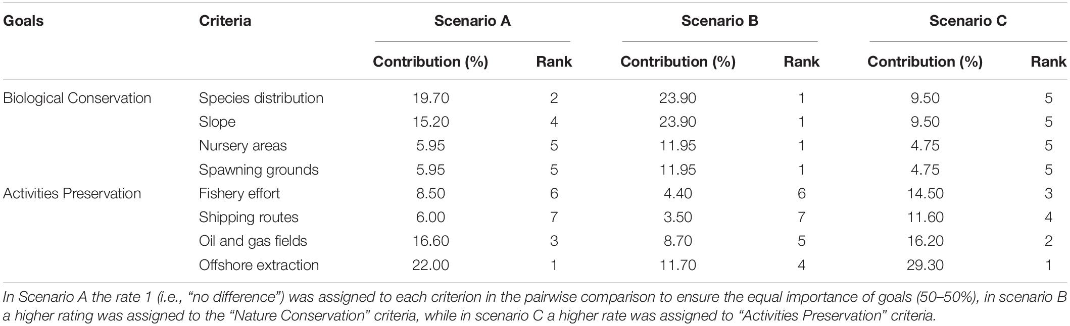
Table 2. Contributions and ranks of criteria to the final results in the different scenarios.
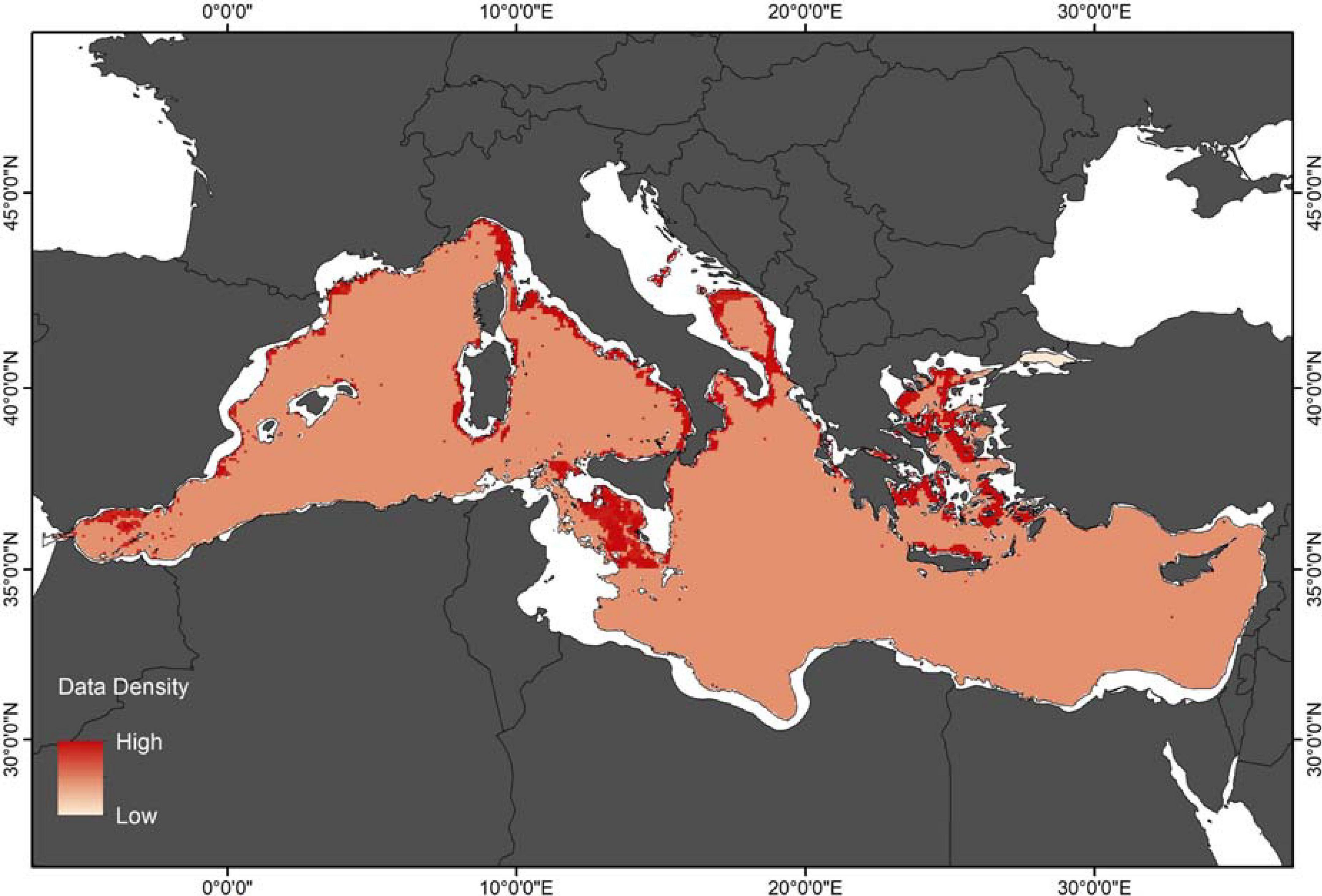
Figure 1. Density data map for all the criteria used in Multi-Criteria Decision Analysis (MCDA).
Expert Evaluation
The process of expert evaluation (EE) encompassed the compilation of background information and considerations, the establishment of two sets of criteria for the evaluation of suggested areas, the resulting selected areas described in individual descriptive sheets (Annex 1 in Supplementary Material), a final compilation of the results with further recommendations, and the suggested final monitoring target (aim) for the deep Mediterranean Sea. The selection of key areas for conservation and monitoring was based on the assessment of two sets of criteria targeting the ecological relevance (ER criteria) of the area and anthropogenic threats (AT criteria) (Figure 2), actually or potentially impacting the area (Supplementary Table 2), assessed by experts’ evaluation. The set of ER criteria should compile all the relevant properties of key areas. Criteria in previous initiatives (CBA, UNEP-MAP-RAC/SPA, PSSA, and Habitats Directive 92/43/EEC) were revised (49 criteria in total, see Supplementary Table 3), adapted and incorporated, for a final selection of 11 ER criteria (Table 3), which take into account the presence of unique/rare species, the importance for threatened, endangered or declining species and/or habitats or areas that contain rare biogeographic qualities or are representative of biogeographic types, the natural representativeness, i.e., areas representative of ecological or physiographic processes, biodiversity, etc. Still, areas that are biologically functional units, effective self-sustaining ecological entities, or where exchanges between different marine compartments are significantly taking place, or that are already part of marine protected areas or other defined site of interest have been also considered in the prioritization criteria (Table 3). Accordingly, AT criteria should reflect the most relevant pressures on the deep Mediterranean Sea (31 criteria in total, see Supplementary Table 4). Consequently, apart from the threats listed in the MSFD, peer-reviewed articles and other documents were examined (e.g., Piante and Ody, 2015) and finally 12 AT criteria were selected (Table 3). Main threats considered here were, among others, the introduction of alien species, overfishing and stock depletion, increase in nutrients input or pollution (sensu lato, i.e., dispersal and accumulation of contaminants in the environments and in the biota) alteration of the seabed, of the hydrological properties of the water column, etc. Scientists from different disciplines (microbiology, benthic biology, deep-sea ecology, marine policy, habitat mapping, biogeochemistry, marine geology, physical oceanography) and policy makers from several Mediterranean countries (Spain, France, Italy, Malta, Greece, Cyprus, Israel) were involved in the evaluation of the criteria. Priority areas were selected according to evaluation scores and considering those achieving a threshold value of 70 scores or more (Supplementary Table 5), i.e., about one third of the maximum number of possible scores, which was 209, considering all criteria and participants in the evaluation. The assessment was performed following a three-level scoring system that considered the level of relevance and/or applicability of each criterion to a particular area. The three-level scoring system ranged from 0 to 3, with 0 allocated when the criterion was not applicable, or data insufficiency prevented a sound evaluation. Subsequently, 1 meant low, 2 medium, and 3 high applicability and/or relevance. The score of 0 for a given area due to data insufficiency needs to be highlighted to foster the acquisition of at least basic information for that area. Although expert evaluation might present some limitations and caveats (Game et al., 2013), scoring systems have been repeatedly used in expert evaluation approaches for the prioritization of marine areas to be protected at a global scale (Halpern et al., 2007; Danovaro et al., 2020b).

Figure 2. Diagram summarizing the process of classifying the areas suggested based on scores regarding Ecological Relevance (ER) and Anthropogenic Threats (AT). The red color represents Type 1 areas and the green refers to Type 2.
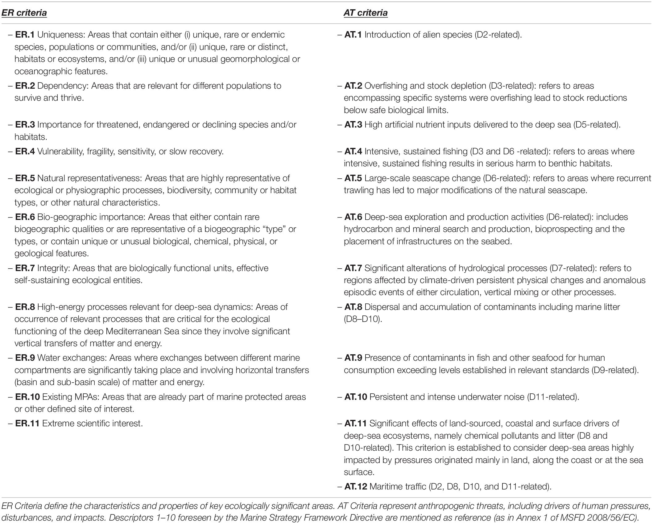
Table 3. Description of ecological relevance (ER) and anthropogenic threats (AT) criteria used in the expert judgment.
Following the scoring of the two sets of criteria, an averaged score was obtained for each set. Accordingly, each candidate area was characterized by two scores (ER and AT averaged scores, Figure 2). The subsequent classification process, based on these two scores and guided by a basic set of rules, defined two types of key areas, labeled Type 1 and Type 2. Type 1 key areas, of priority monitoring under AT (vs. GES, Good Environmental Status, sensu MSFD), are characterized by high ER, but also high occurrence/intensity of AT. Type 2 key areas are suggested for priority monitoring (and eventual protection), because of their high ER and naturalness even though they are currently experiencing a low level of human-induced degradation (low AT scores).
Results
Multi-Criteria Decision Analysis
Data used in the MCDA display heterogeneous distribution and density (Figure 1), with a near complete absence of information for the southern and easternmost Mediterranean Sea compared to the western and central Mediterranean and the Aegean Sea, for which there are more extensive data on species distribution, spawning grounds, and nursery areas. The data coverage regarding slope gradient and shipping intensity extends to the whole basin. The three scenarios provide high suitability in specific areas, with values decreasing from Scenario A to Scenario C (Table 4).
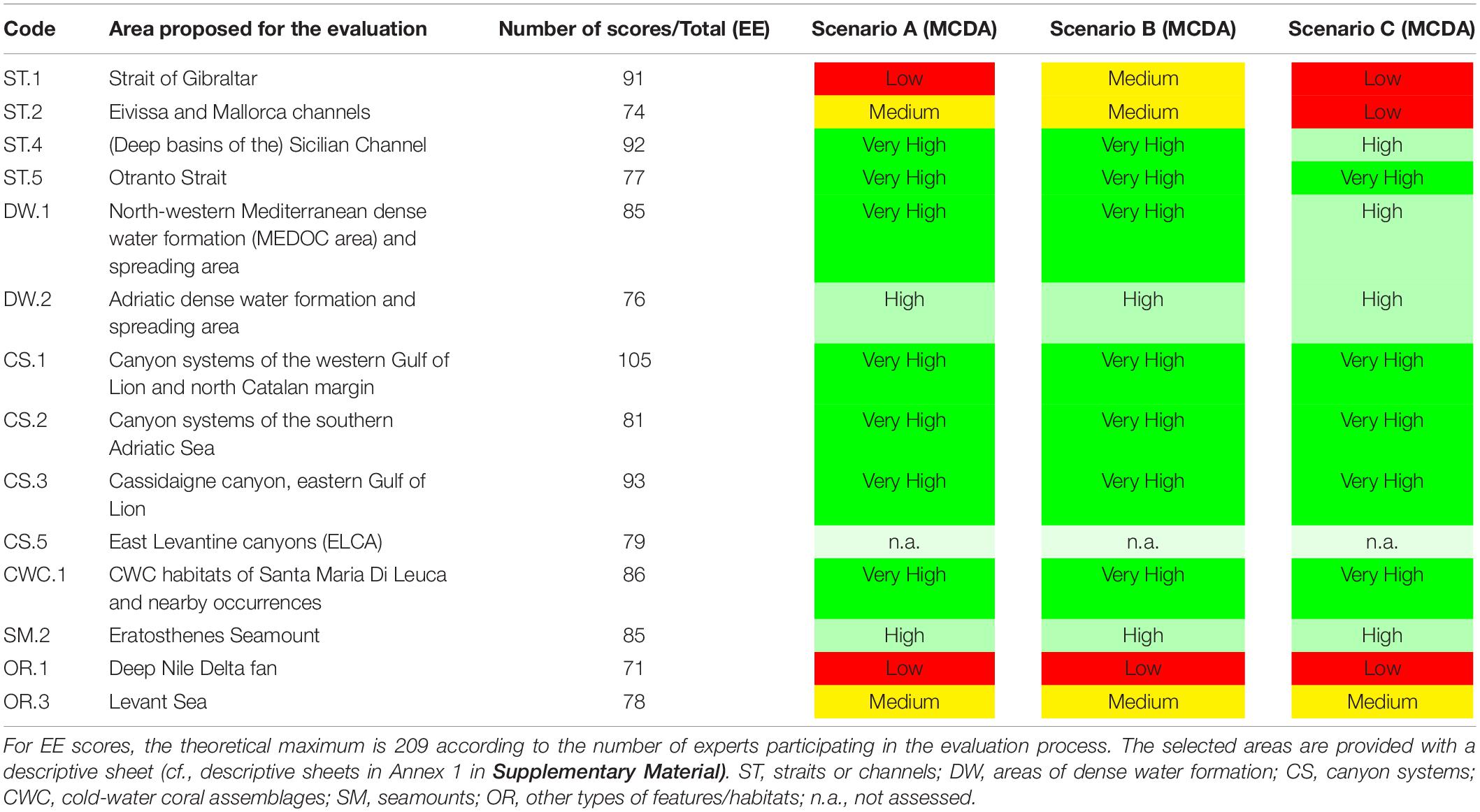
Table 4. List of Type 1 areas according to expert evaluation (EE), with the number of scores obtained by each of them, and suitability scores according to the three scenarios of the multi-criteria decision analysis (MCDA), also for each of them. Colors for the different scenarios of the MCDA represent the score obtained by the analysis: red = low score; yellow = medium score; light green = high score and green = very-high score.
The Italian margin shows the highest suitability values (Figures 3A–C), because of the larger number of species occurrence with elevated threat category (from “Vulnerable” to “Critically Endangered”) and the presence of nursery areas and spawning grounds. In the Aegean Sea, the high number of reproduction areas (spawning and nursery areas), together with the presence of threatened species concur in increasing the suitability of the area. In the Sicily Channel, the suitability is positively influenced by the presence of cold water corals (CWCs) and negatively by the shipping and fishing activities occurring in the area, resulting in moderate-to-high values (Figure 3). The high suitability of the French margins is related to the presence of geomorphological features (i.e., canyons), which host CWCs and related communities. Along the Spanish margin, only patches of high suitability have been identified (Figure 3). In the Gibraltar Strait, results are critically influenced by the intense shipping activity in the area, masking the presence of vulnerable species such as CWCs (Table 4).
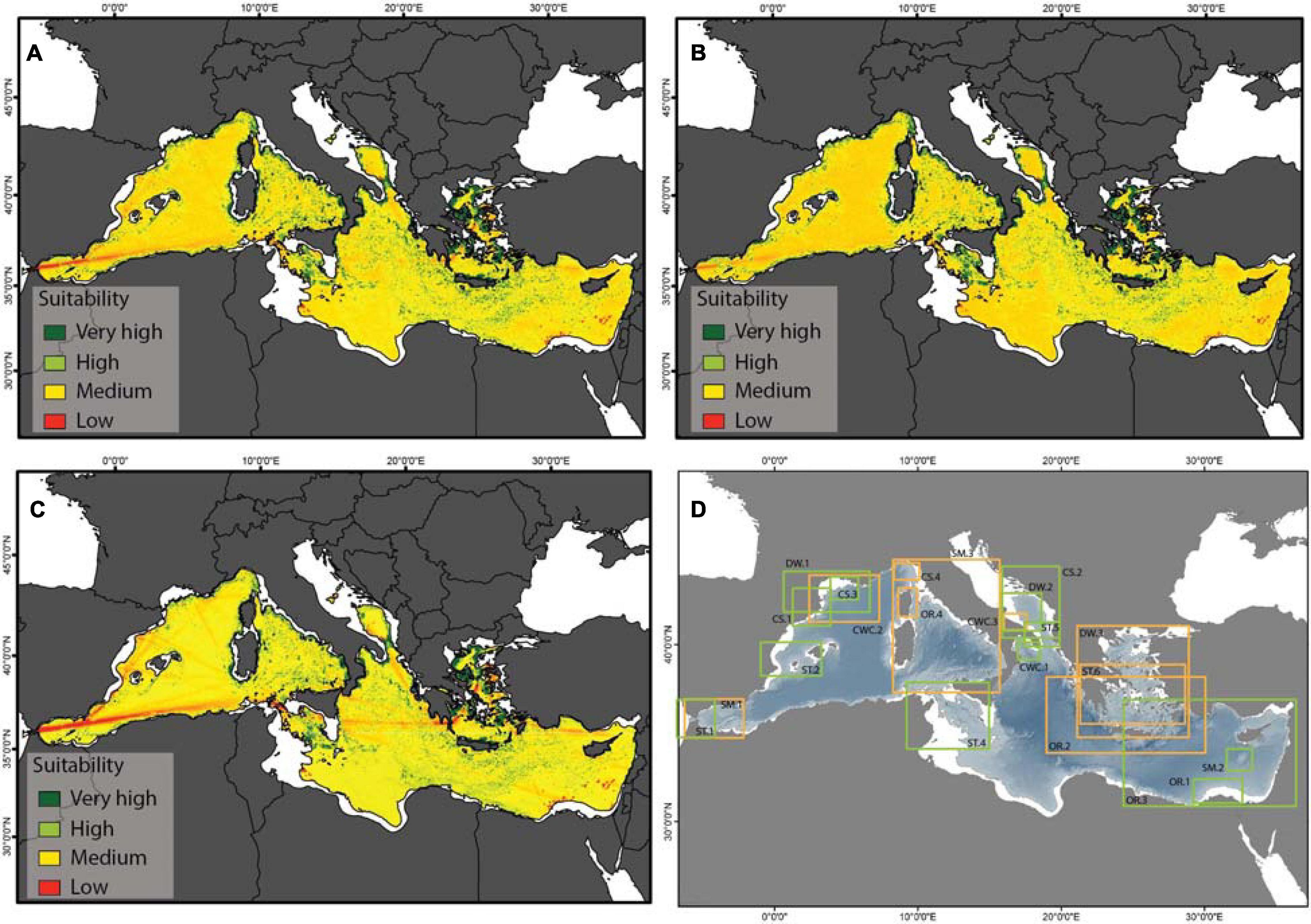
Figure 3. Results of Multi-Criteria Decision Analysis (MCDA) outputs (A–C) and of expert evaluation (D): (A) MCDA output for Scenario A; (B) MCDA output for Scenario B; (C) MCDA output for Scenario C; (D) potential key areas for conservation highlighted by rectangles and identified by the area’s code, as in Table 3. The green rectangles identify the areas finally selected for priority monitoring and conservation (Table 3), whereas the orange ones are Putative Priority Areas (PPA) not selected as they fell below the 70 scores threshold (Supplementary Table 5). Areas shallower than 200 m depth are depicted in white.
Expert Evaluation Analysis
The experts proposed 23 deep-water areas of ER as candidate areas for monitoring and protection, encompassing different environments and critical processes, of which all but one were qualified as Type-1 areas (Supplementary Table 5 and Figure 3D). The exception was the Eastern Corsican slope in view of its very low level of AT. Of the 23 areas, nine were discarded, including the Eastern Corsican slope, as they obtained less than 70 scores. Amongst the remaining 14, 13 were retained as priority targets for protection (Table 4) and one was also discarded following the experts’ recommendation. An individual descriptive sheet is provided for each of the 13 Type-1 key areas in the Annex 1 of the Supplementary Material.
Discussion
Comparison of the Two Approaches
Different studies have identified areas of conservation concern in the Mediterranean Sea where high diversity and high threats overlap (Coll et al., 2012), looking at high conservation values vs. special habitats or human activities (Micheli et al., 2013). Still these studies only partially consider deep-sea ecosystems. Here we also considered “priority areas for conservation of species at risk,” or PACS, as suggested by Coll et al. (2015). According to Sustainable Development Goal 14, and target 14.5 in particular, to meet global conservation goals protection must be “based on the best available scientific information,” and following the Aichi target 11, located in “areas of particular importance for biodiversity and ecosystem services.” To achieve these two, here we used some of the existing best-practice methods for spatial conservation prioritization, with the first one (MCDA) based on the available scientific information (Asaad et al., 2018; Esmail and Geneletti, 2018), further integrated with expert evaluation (Martin et al., 2012; Ward, 2014), an approach that is particularly useful in data poor areas, such as the southern and part of the eastern Mediterranean Sea in our exercise.
Multi-criteria decision analysis has been increasingly used in conservation biology to support the identification of the most suitable areas among several alternatives. MCDA, indeed, integrates the operational information coming from field surveys and/or modeling, with value-based information collected through stakeholder engagement (e.g., Strager and Rosenberger, 2006; Nordström et al., 2011). One drawback of MCDA is that the density of data used as indicators is only considered in terms of spatial coverage and does not provide information on the values of each indicator. Thus, a high density of data reflects a larger amount of spatial information on a certain indicator (e.g., on species occurrence), but not necessarily a greater presence of threatened species (i.e., sensu IUCN, critically endangered, endangered, or vulnerable). This is why MCDA is often integrated with other methods and tools, like participatory approaches. Indeed, while MCDA is primarily dependent upon data availability, qualitative EE draws on the overall set of information accumulated by the experts in the field, which often is much wider than that available in geodatabases.
The two approaches, therefore, complement each other. For instance, MCDA might be supported by data from key monitoring areas identified after EE. Also, EE can identify areas of potentially high ecological relevance, hereafter defined as Putative Priority Areas (PPAs), where the lack of data hinders their identification through MCDA. As an example, a recent survey of the slope fauna in the Levantine Sea revealed distinct and unique assemblages, differing in composition and relative abundance of taxa from slope habitats elsewhere in the Mediterranean Sea (Goren et al., 2020). In view of the vulnerability and low resilience of epibenthic soft bottom slope assemblages and the rapid development of regional offshore gas and oil fields, the precautionary approach is invoked to extend protection to the deep biota in “data-deficient” regions (Goren et al., 2020).
Although such techniques can be problematic, especially in terrestrial and coastal environments (Wolman, 2006; Game et al., 2013), these are still the best tools for prioritization analysis in spatial conservation in the data-deficient deep sea. The conservation tool used in this study mostly relies on spatial data. Some authors (Lundquist and Granek, 2005; Gilman et al., 2011) highlighted the importance of stakeholders’ involvement for successful marine conservation strategies, or provided a complete list of socioeconomic and governance criteria, mostly in the form of non-spatial data. Incorporating socioeconomic and policy variables into spatial prioritization may lead to higher chances to support the siting and implementation of MPAs. This is especially true for coastal MPAs whose institution may create conflicts of use with recreational activities. However, for offshore MPAs, governance criteria (e.g., management, surveillance, and enforcement), may be more important than social and thus stakeholders involved would be better identified within management levels of ministries and regional agencies dealing with the environment at large.
In the present study, the two approaches yielded similar results in terms of identification of deep-sea areas deserving protection (Figure 3). Submarine canyons appear as crucial areas for protection in both approaches, also because many host CWCs and/or other vulnerable ecosystems (De Leo et al., 2010; Fabri et al., 2014). Straits, channels and other choke points, where water mass exchanges between different basins occur (Astraldi et al., 1999), are identified as priorities for protection as well. Certain areas like the Sicilian Channel and Otranto Strait, submarine canyons of the southern Adriatic Sea, or specific CWC habitats appear as shared outputs of the two approaches. Conversely, the Strait of Gibraltar and the Deep Nile Delta Fan did not result as priority areas from the MCDA, likely because of insufficient information on biological features for the first (i.e., the occurrence of significant CWCs: Corbera et al., 2019), or the absence of “iconic” species in the second, although the Deep Nile Delta Fan is dominated by reduced sediments and microbial mats hosting unique ecosystems of tubeworms, chemosymbiotic bivalves, urchins, and crustaceans (Foucher et al., 2015). MCDA is an efficient management tool for providing suitability maps, which can serve to reach a large portion of stakeholders. At the same time, expert knowledge of the ecological features of deep-sea habitats is essential when MCDA is applied for planning deep-sea conservation, eventually involving further monitoring and research. Our results suggest that MCDA is a good tool to identify priority areas when large datasets are available. However, in the case of deep-sea habitats, which are hardly accessible and, consequently, for which only scarce or fragmented data are generally available, EE represents the most valid option and indeed is increasingly being used in conservation science (Martin et al., 2012).
Protection Criteria for the Deep Sea
Considering the current legislative framework and the results of the integrated analyses performed, here we proposed three key actions to define the criteria for increasing the protection of deep-sea ecosystems of the Mediterranean Sea (Figure 4):
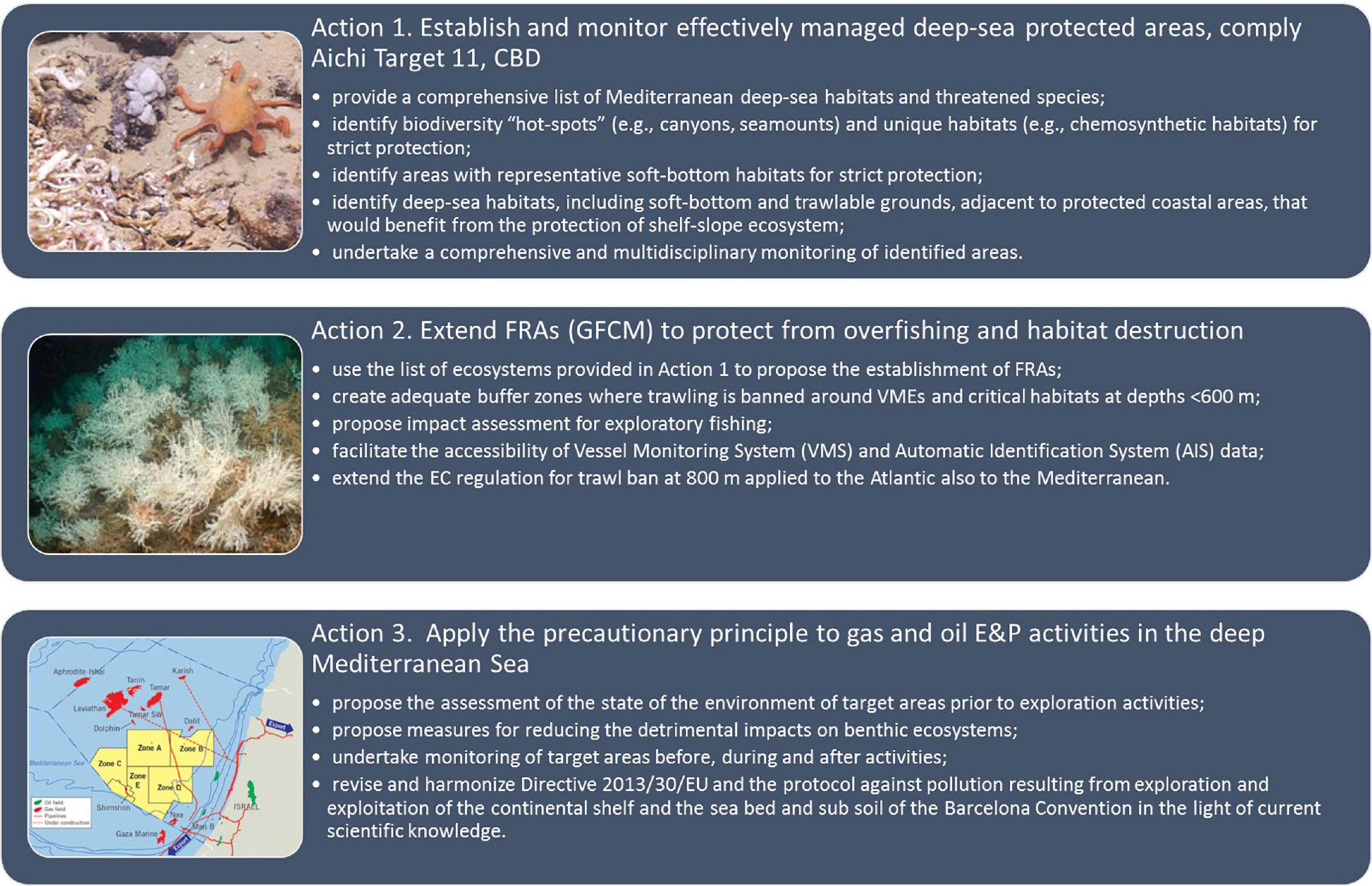
Figure 4. Actions proposed for implementing the protection of ecosystems in the deep Mediterranean Sea and against the two main anthropogenic threats (AT), which are deep-sea fisheries and oil and gas exploration and production (E&P).
Action 1. Identification and protection of VMEs and the species they support.
Action 2. Improvement of fishery management measures.
Action 3. Application of the precautionary approach to E&P.
Action 1 also requires the extension of existing coastal MPAs and National Parks to adjacent deep-sea areas. There are already some successful cases, such as the extension of the French Port-Cros National Park and Spanish MPAs to the adjacent deep-sea canyons and seamounts hosting CWCs (WWF/Adena, 2005) and the inclusion of Cuma Canyon in the Italian MPA “Regno di Nettuno.” This approach protects the connectivity between shallow and deep-sea populations, while maximizing the returns from infrastructures, management tools and facilities from existing MPAs.
In this context, we recommend the identification of MPAs in the deep Mediterranean Sea be based on the following criteria, in line with CBD (2010) Aichi Target 11, while also complying with some of the principles highlighted by Katsanevakis et al. (2020):
1. Full protection is recommended for deep-sea biodiversity hotspots, such as (but not limited to) those containing CWCs.
2. We suggest extending the protection to deep-sea areas adjacent to existing MPAs and including VMEs and/or VME indicator species, able to support the shelf-to-slope endangered or exploited species connectivity.
3. MPAs should be designated equitably across the different biogeographic regions of the Mediterranean Sea, and in accordance with sound scientific criteria, to ensure representativeness and uniqueness.
4. We recommend the protection of all PPAs that can support high levels of biodiversity and are subject to increasing threat from human activities.
5. Application of the precautionary approach for all areas planned as new deep-water fishing grounds and/or gas and oil fields, so that any activity planned in open waters and on the deep seafloor is subordinated to the outcomes of a strict Environmental Impact Assessment (EIA) and a Strategic Environmental Assessment (SEA), sensu Capacity4dev6. This applies particularly to areas, such as the eastern sub-basin, which are less known in terms of habitats and biodiversity and to areas beyond EU jurisdiction.
Such criteria are summarized in Figure 5 with the selection of priority areas for conservation actions, as issued from the present work.
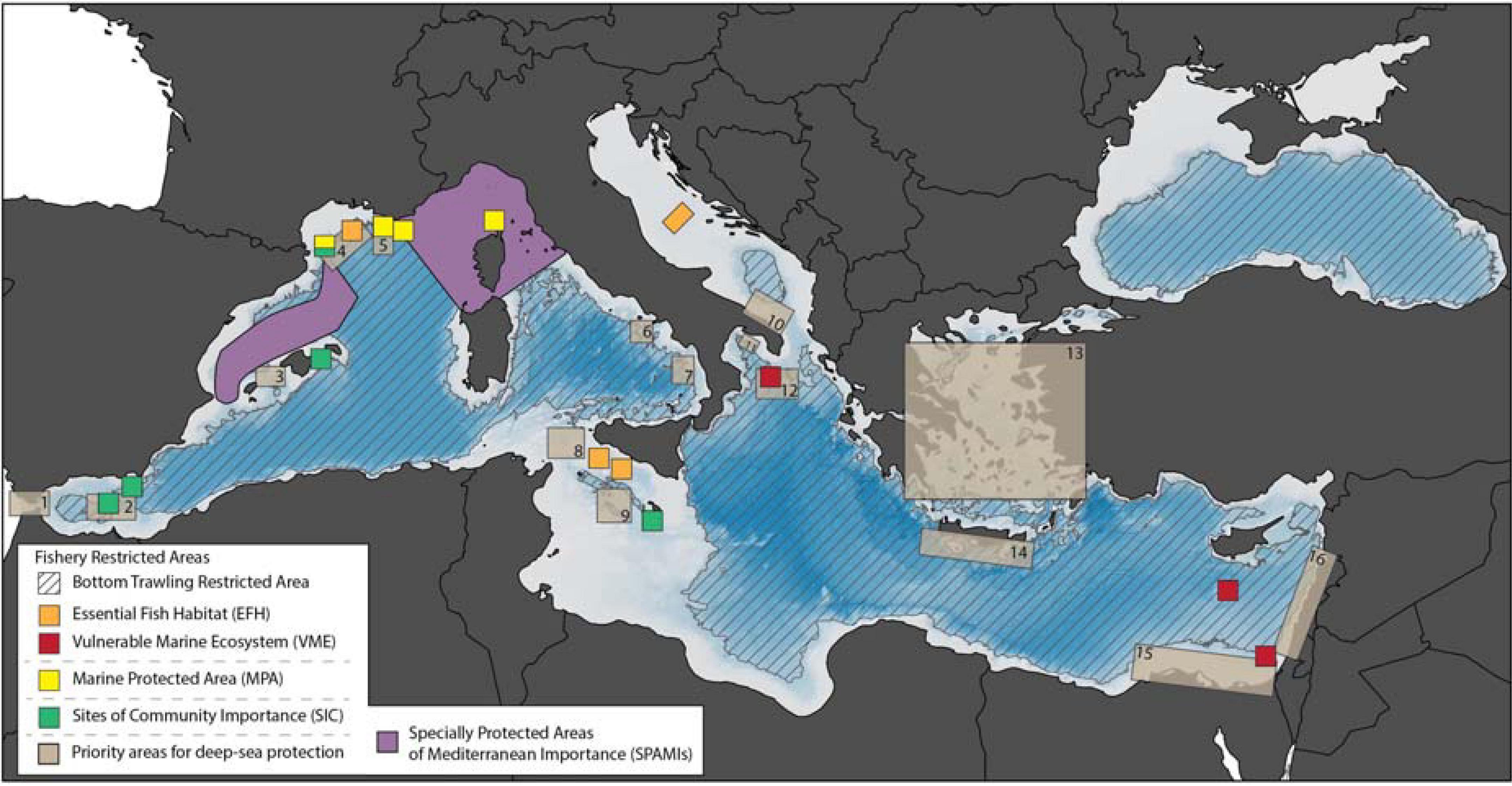
Figure 5. Map of the Mediterranean deep-sea areas already under management measures and those identified as priority for conservation actions through the present work. Numbers on light brown rectangles indicate the areas identified, specifically 1. Strait of Gibraltar; 2. Alborán Sea; 3. Eivissa and Mallorca channels; 4. Canyon systems of the western Gulf of Lion and north Catalan margin; 5. Cassidaigne Canyon; 6. Dohrn Canyon; 7. Calabrian canyon system; 8 and 9. Deep basins of the Sicilian Channel; 10. Bari Canyon; 11. Apulian deep-sea bottoms, including the Bari Canyon; 12. CWC habitats of Santa Maria di Leuca; 13. Deep bottoms of the Aegean Sea; 14. Hellenic Trench south of Crete Island; 15. Deep Nile Delta Fan; 16. East Levantine canyons. VME areas banned to fishery, seamounts, and other similar features, and other fishery management measures from the FAO VME database (accessed January 2021).
As an example, based on criterion 1, areas like the Santa Maria di Leuca CWC province in the Ionian Sea that are only protected from fishing activities as FRA, or areas hosting VMEs such as the Eratosthenes Seamount and the Deep Nile Delta Fan, should be fully protected from all human activities threatening their GES.
Regarding criterion 2, the boundaries of some MPAs, such as “Cinque Terre” in the Ligurian Sea, or “Punta Campanella” in the Southern Tyrrhenian, could be extended to include the adjacent Levante and Dohrn submarine canyons, both including VMEs (Fanelli et al., 2017; Taviani et al., 2019).
The deep Mediterranean portion protected as MPAs or OECMs (ca. 4.9%, Manea et al., 2020) is mostly concentrated in the north-western sector, thus new deep-sea MPAs should be designated in the central and the eastern Mediterranean Sea. For example, the deeper part of the Sicilian Channel and the Otranto Strait with the submarine canyon system of the Southern Adriatic, all located in the Central Mediterranean, and the bathyal soft bottoms of the Levantine Sea (Eastern Mediterranean), should be selected to accomplish criterion 3. Following criterion 4, PPAs deserving protection include the Gioia Canyon and the Palmi Ridge (southern Tyrrhenian) (Figure 5), where black corals, sea pens and bamboo corals are present (Pierdomenico et al., 2018).
Finally, to accomplish the fifth criterion, a precautionary approach is recommended for deep-sea areas, such as the deep Levantine Sea, where major gas fields (i.e., Zohr, Aphrodite, and Leviathan) have been found, but there is evidence of the presence of vulnerable or critical habitats, with rare sponges, hydrozoans, anthozoans, and brachiopod fields (Galil et al., 2018; Goren et al., 2020) or presumption of the presence of deep-water corals based on bathymetric variables (Dolan et al., 2008).
The first step for the institution of MPAs in the deep sea is the establishment of policy instruments, followed by effective governance sustained by long-term commitment, without which any MPA would share the same fate of previously designated protected areas, which covered ca. 6% of the Mediterranean Sea (up to 9.7% considering measures other than MPAs, Gomei et al., 2019), yet only 0.23% is fully or highly protected (Claudet et al., 2020).
An integrated management strategy would help to ensure better use of existing resources and capacities, avoiding duplication of efforts, enhancing capacity building, and favoring strategic regional joint projects. Conservation priorities require the cost of protection to be considered as well, thus considering main threats to diversity and how feasible it is to cover the cost of protection and to halt or reverse a threat (Mazor et al., 2014). Calculating the cost of a threat is challenging, and to date the cost of protection in spatial planning is frequently estimated via proxies or surrogates such as human population densities or total landings (Giakoumi et al., 2013; Mazor et al., 2014), however, such estimates in the deep sea mostly rely on the cost for technological/infrastructural capacity for monitoring. Small and non-EU countries may lack the technological/infrastructural capacity and the scientific/technical expertise necessary for deep-sea research and monitoring.
Given that deep-sea investigations are expensive and require advanced technologies, we recommend, for the implementation of MPAs in the southern Mediterranean Basin, fostering and financially support close collaboration between EU and non-EU Mediterranean countries, which is a relevant factor for the feasibility of protection measures also in non-EU countries (Levin et al., 2013).
While in our approach for the MCDA, different layers such as species diversity, habitat heterogeneity, benthic features, and the most important anthropogenic threats, including fishing, were included in the MCDA, other important aspects such as productivity could be considered in the future (Visalli et al., 2020). Further, implementations of the approach here proposed need to take into account the potential impact of climate change, which is certainly one of the main drivers of present and future alteration of marine biota, including the deep sea (Levin and Le Bris, 2015) and the expectable onset of novel ecosystems (Hobbs et al., 2009; Morse et al., 2014). Indeed, while it is true that MPAs are a key tool to mitigate the impact of global change and the threats to marine biodiversity (Allison et al., 1998; Edgar et al., 2014), they are at the same time increasingly impacted by climate change. Models foresee increased temperature and oligotrophy in the Mediterranean Sea (Taucher and Oschlies, 2011), which will cause shifts in richness, assemblage composition and abundance of marine biota (Galil et al., 2018; Goren et al., 2020). Such changes are expected to impact also the deep-sea ecosystem (Somot et al., 2016) and the species and communities it holds (Danovaro et al., 2004; Philippart et al., 2011; Danovaro, 2018). Studies show that some features for which MPAs have been designated may have their distributions significantly affected by climate change, leading to challenges in the ongoing management of the protected areas (Gormley et al., 2015). In this context there is an urgent need to set up programs for long-term data monitoring or to globally analyze the few already existing ones. Long-term data are needed for understanding of change in marine ecosystems, reducing scientific uncertainty and ultimately increasing the robustness of management decisions. For example, the separation of climatic and anthropogenic signals in marine ecosystems remains a basic scientific research question as well as a challenge to selecting indicators and setting environmental targets. Finally, long-term data sets are necessary for the early detection of signals of impact and resilience, through simple and effective “indicators” such as shifts in species distribution or local extinctions and their recovery over time (Danovaro et al., 2020b).
Conclusion
Most of the existing MPAs and OECMs are concentrated along the western and northern Mediterranean Sea (73% of the marine territory has some form of protection in the north-western Mediterranean; Gomei et al., 2019). To achieve Aichi Target 11 in the Mediterranean Sea, an additional 71,900 km2 (2.9% of the entire area) should come under protection. Further, protection of the deep sea is even more essential to meet the EU 2030 Biodiversity Strategy. Since 79% of the Mediterranean basin is deep (i.e., >200 m; Manea et al., 2020) the Achievement of the Aichi Target 11 is possible only if we include deep-sea areas. To promote this process and fill current gaps we identified the criteria needed for prioritizing the deep-sea areas deserving ecosystem conservation. In the foreseeable future, protection measures should primarily target the under-represented biogeographic regions of the Central Mediterranean, Ionian and Aegean-Levantine areas, and especially those in the southern part of the basin. Our results indicate that the priority deep Mediterranean areas deserving protection are those characterized by the occurrence of unique and/or vulnerable ecosystems, and those jeopardized by human impacts (i.e., new fishing grounds or E&P areas in deep continental margins and basins eventually overlapping with deep-water FRAs). These areas include submarine canyons, straits, and channels (e.g., Eivissa and Mallorca, Sicily, Otranto). Where possible, deep-sea habitat protection may be contiguous with already protected coastal MPAs. The criteria proposed in the present study advance a robust identification of the priority deep-sea areas to protect, to be utilized by policy makers in their decisions, hopefully in a not too distant future, also beyond the Mediterranean Basin.
Data Availability Statement
The original contributions presented in the study are included in the article/Supplementary Material, further inquiries can be directed to the corresponding author.
Author Contributions
RD, EF, and SB conceived the idea. GC, FF, and QG-B made the analyses. EF and SB wrote the manuscript. RD revised the initial draft. All authors contributed to the implementation of the original draft.
Funding
This study was supported by the DG ENV project IDEM (Implementation of the MSFD to the Deep Mediterranean Sea; contract EU No. 11.0661/2017/750680/SUB/EN V.C2). MC and QG-B acknowledge support from Generalitat de Catalunya autonomous government through its funding scheme to excellence research groups (Grant 2017 SGR 315).
Conflict of Interest
The authors declare that the research was conducted in the absence of any commercial or financial relationships that could be construed as a potential conflict of interest.
Acknowledgments
The authors wish to thank all the participants to the IDEM Project and all respondents to the questionnaire for the “Expert Evaluation” section. This is ISMAR-CNR, Bologna scientific contribution n. 2030.
Supplementary Material
The Supplementary Material for this article can be found online at: https://www.frontiersin.org/articles/10.3389/fmars.2021.698890/full#supplementary-material
Abbreviations
ABNJ, Areas Beyond National Jurisdiction; ACCOBAMS, Conservation of Cetaceans in the Black Sea Mediterranean Sea and Contiguous Atlantic Area; AHP, Analytic hierarchy process; AIS, Automatic Identification System (for vessels); AT, Anthropogenic threats; BHT, Broad Habitat Types (MSFD); CBD, Convention on Biodiversity; CCAMLR, Commission for the Conservation of Antarctic Marine Living Resources; CWC, Cold-water corals; EBSA, Ecologically or Biologically Significant marine Areas; EE, Expert evaluation; EFH, Essential Fish Habitat; EIA, Environmental Impact Assessment; E&P, Exploration and production (of oil and gas); ER, Ecological relevance; FRA, Fisheries Restricted Area; GES, Good Environmental Status; GFCM, General Fisheries Commission for the Mediterranean; HD, Habitats Directive; IDEM, Implementation of the MSFD to the DEep Mediterranean Sea; IUCN, International Union for Conservation of Nature; MCDA, Multi criteria decision analysis; MPA, Marine Protected Area; MS, Member States; MSFD, Marine Strategy Framework Directive; MSP, Marine Spatial Planning; OECM, Other Effective area-based Conservation Measure; PPA, Putative Priority Areas; RAC/SPA, Regional Activity Centre for Specially Protected Areas; RFMOs, Regional Fisheries Management Organizations; SCI, Sites of Community Importance, Habitat Directive; SEA, Strategic Environmental Assessment; SPAMI, Specially Protected Areas of Mediterranean Importance; SPRFMO, South Pacific Regional Fisheries Management Organisation; UNEP-MAP, United Nations Environment Programme – Mediterranean Action Plan, Barcelona Convention; VME, Vulnerable Marine Ecosystems.
Footnotes
- ^ http://www.indemares.es/
- ^ https://lifebahar.org.mt/
- ^ So far the Pelagos Sanctuary in the Ligurian Sea is the only open water area designated for the conservation of marine mammals in the Mediterranean Basin, which should encompass also the deep-water column.
- ^ www.iucnredlist.org
- ^ http://www.msfd-idem.eu/
- ^ https://europa.eu/capacity4dev/public-environment-climate/wiki/strategic-environmental-assessment
References
Aguzzi, J., Chatzievangelou, D., Marini, S., Fanelli, E., Danovaro, R., Flogel, S., et al. (2019). New high-tech interactive and flexible networks for the future monitoring of deep-sea ecosystems. Environ. Sci. Technol. 53, 6616–6631. doi: 10.1021/acs.est.9b00409
Allison, G. W., Lubchenco, J., and Carr, M. H. (1998). Marine reserves are necessary but not sufficient for marine conservation. Ecol. Applicat. 8, S79–S92. doi: 10.1890/1051-076119988[S79:MRANBN]2.0.CO;2
Andrews, A. H., Stone, R. P., Lundstrom, C. C., and DeVogelaere, A. P. (2009). Growth rate and age determination of bamboo corals from the northeastern Pacific Ocean using refined 210Pb dating. Mar. Ecol. Prog. Ser. 397, 173–185. doi: 10.3354/meps08193
Ardron, J. A., Clark, M. R., Penney, A. J., Hourigan, T. F., Rowden, A. A., Dunstan, P. K., et al. (2014). A systematic approach towards the identification and protection of Vulnerable Marine Ecosystems. Mar. Policy 49, 146–115. doi: 10.1016/j.marpol.2013.11.017
Asaad, I., Lundquist, C. J., Erdmann, M. V., Van Hooidonk, R., and Costello, M. J. (2018). Designating spatial priorities for marine biodiversity conservation in the Coral Triangle. Front. Mar. Sci. 2018:00400. doi: 10.3389/fmars.2018.00400
Astraldi, M., Balopoulos, S., Candela, J., Font, J., Gacic, M., Gasparini, G. P., et al. (1999). The role of straits and channels in understanding the characteristics of Mediterranean circulation. Prog. Oceanogr. 44, 65–108. doi: 10.1016/S0079-6611(99)00021-X
Ban, N. C., Bax, N. J., Gjerde, K. M., Devillers, R., Dunn, D. C., Dunstan, P. K., et al. (2014). Systematic conservation planning: a better recipe for managing the high seas for biodiversity conservation and sustainable use. Conservat. Lett. 7, 41–54. doi: 10.1111/conl.12010
Barbier, E. B., Moreno-Mateos, D., Rogers, A. D., Aronson, J., Pendleton, L., Danovaro, R., et al. (2014). Ecology: Protect the deep sea. Nature 505, 475–477.
Beinat, E., and Nijkamp, P. (1998). Multicriteria analysis for land-use management, Vol. Vol. 9. Amsterdam: Springer Science & Business Media.
Benn, A. R., Weaver, P. P., Billet, D. S. M., van den Hove, S., Murdock, A. P., Doneghan, G. B., et al. (2010). Human activities on the deep seafloor in the North East Atlantic: an assessment of spatial extent. PLoS One 5:e12730. doi: 10.1371/journal.pone.0012730
Bianchi, N., and Morri, C. (2000). Marine biodiversity of the Mediterranean Sea: Situation, problems and prospects for future research. Mar. Pollut. Bull. 40, 367–376. doi: 10.1016/s0025-326x(00)00027-8
CCAMLR (2009). CCAMLR Vulnerable Marine Ecosystem (VME) Taxa Identification Guide Version 2009. Hobart: Commission for the Conservation of Antarctic Marine Living Resources.
Carbonara, P., Zupa, W., Maria Cristina, Follesa, M.-C., Cau, A., Capezzuto, F., et al. (2020). Exploring a deep-sea vulnerable marine ecosystem: Isidella elongata (Esper, 1788) species assemblages in the Western and Central Mediterranean. Deep Sea Res. I 166:103406. doi: 10.1016/j.dsr.2020.103406
CBD (Convention on Biological Diversity) (2010). COP 10 Decision X/2. Strategic Plan for Biodiversity 2011-2020. Rio de Janeiro: CBD.
Chimienti, G., Mastrototaro, F., and D’Onghia, G. (2020). “Mesophotic and Deep-Sea Vulnerable Coral Habitats of the Mediterranean Sea: Overview and Conservation Perspectives,” in Advances in the Studies of the Bentic zone, ed. L. A. Soto (London: IntechOpen Publishers), doi: 10.5772/intechopen.90024
Clark, M. R., and Dunn, M. R. (2012). Spatial management of deep-sea seamount fisheries: balancing sustainable exploitation and habitat conservation. Environ. Conservat. 39, 204–214. doi: 10.1017/s0376892912000021
Claudet, J., Loiseau, C., Sostres, M., and Zupan, M. (2020). Underprotected Marine Protected Areas in a Global Biodiversity Hotspot. One Earth 2, 380–384. doi: 10.1016/j.oneear.2020.03.008
Coll, M., Piroddi, C., Albouy, C., Ben Rais, Lasram, F., Cheung, W. W. L., et al. (2012). The Mediterranean Sea under siege: spatial overlap between marine biodiversity, cumulative threats and marine reserves. Glob. Ecol. Biogeogr. 21, 465–480. doi: 10.1111/j.1466-8238.2011.00697.x
Coll, M., Steenbeek, J., Ben Rais, Lasram, F., Mouillot, D., and Cury, P. (2015). “Low hanging fruits” for conservation of marine vertebrate species at risk in the Mediterranean Sea. Glob. Ecol. Biogeogr. 24, 226–239. doi: 10.1111/geb.12250
Colloca, F., Garofalo, G., Bitetto, I., Facchini, M. T., Grati, F., Martiradonna, A., et al. (2015). The Seascape of Demersal Fish Nursery Areas in the North Mediterranean Sea, a First Step Towards the Implementation of Spatial Planning for Trawl Fisheries. PLoS One 10:e0119590. doi: 10.1371/journal.pone.0119590
Combes, M., and Vaz, S. (2019). Systematic conservation planning for the North-Atlantic deep sea. Edinburgh: SEANOE, doi: 10.17882/62541
Comm. Dec. 848/2017. Available online at: https://mcc.jrc.ec.europa.eu/documents/ComDec/Com_dec_GES_2017_848_EU.pdf
Corbera, G., Lo Iacono, C., Gràcia, E., Grinyó, J., Pierdomenico, M., Huvenne, V. A. I., et al. (2019). Ecological characterisation of a Mediterranean cold-water coral reef: Cabliers Coral Mound Province (Alboran Sea, western Mediterranean). Progr. Oceanogr. 175, 245–262. doi: 10.1016/j.pocean.2019.04.010
Daly, E., and White, M. (2021). Bottom trawling noise: Are fishing vessels polluting to deeper acoustic habitats? Mar. Pollut. Bull. 162:111877. doi: 10.1016/j.marpolbul.2020.111877
Danovaro, R. (2018). Climate change impacts on the biota and on vulnerable habitats of the deep Mediterranean Sea. Rend. Fis. Acc. Lincei 29, 525–541. doi: 10.1007/s12210-018-0725-4
Danovaro, R., Aguzzi, J., Fanelli, E., Billett, D., Gjerde, K., Jamieson, A., et al. (2017). An ecosystem-based deep-ocean strategy. Science 355, 452–454. doi: 10.1126/science.aah7178
Danovaro, R., Company, J. B., Corinaldesi, C., D’Onghia, G., Galil, B., Gambi, C., et al. (2010). Deep-Sea Biodiversity in the Mediterranean Sea: The Known, the Unknown, and the Unknowable. PLoS One 5:e11832. doi: 10.1371/journal.pone.0011832
Danovaro, R., Dell’Anno, A., and Pusceddu, A. (2004). Biodiversity response to climate change in a warm deep sea. Ecol. Lett. 7, 821–828. doi: 10.1111/j.1461-0248.2004.00634.x
Danovaro, R., Fanelli, E., Aguzzi, J., Billett, D., Carugati, L., Corinaldesi, C., et al. (2020b). Ecological variables for developing a global deep-ocean monitoring and conservation strategy. Nat. Ecol. Evolut. 4, 181–192. doi: 10.1038/s41559-019-1091-z
Danovaro, R., Fanelli, E., Canals, M., Ciuffardi, T., Fabri, M.-C., Taviani, M., et al. (2020a). Towards a marine strategy for the deep Mediterranean Sea. Mar. Policy 112:103781. doi: 10.1016/j.marpol.2019.103781
Danovaro, R., Snelgrove, P. V. R., and Tyler, P. (2014). Challenging the paradigms of deep-sea ecology. Trends Ecol. Evolut. 29, 465–475. doi: 10.1016/j.tree.2014.06.002
De Leo, F. C., Smith, C. R., Rowden, A. A., Bowden, D. A., and Clark, M. R. (2010). Submarine canyons: hotspots of benthic biomass and productivity in the deep sea. Proc. R. Soc. B Biol. Sci. 277, 2783–2792. doi: 10.1098/rspb.2010.0462
Dolan, M., Grehan, A., Guinan, J., and Brown, C. (2008). Modelling the local distribution of cold-water corals in relation to bathymetric variables: Adding spatial context to deep-sea video data. Deep Sea Res. Part I 55:010. doi: 10.1016/j.dsr.2008.06.010
Duarte, C. M., Chapuis, L., Collin, S. P., Costa, D. P., Devassy, R. P., Eguiluz, V. M., et al. (2021). The soundscape of the Anthropocene ocean. Science 371:eaba4658.
Durden, J. M., Lallier, L. E., Murphy, K., Jaeckel, A., Gjerde, K., and Jones, D. O. B. (2018). Environmental Impact Assessment process for deep-sea mining in ‘the Area’. Mar. Policy 87, 194–202. doi: 10.1016/j.marpol.2017.10.013
Edgar, G. J., Stuart-Smith, R. D., Willis, T. J., Kininmonth, S., Baker, S. C., et al. (2014) Global conservation outcomes depend on marine protected areas with five key features. Nature 506, 216–220. doi: 10.1038/nature13022
Esmail, A. B., and Geneletti, D. (2018). Multi-criteria decision analysis for nature conservation: A review of 20 years of applications. Methods Ecol. Evolut. 9, 42–53. doi: 10.1111/2041-210x.12899
Fabri, M.-C., Pedel, L., Beuck, L., Galgani, F., Hebbeln, D., and Freiwald, A. (2014). Megafauna of vulnerable marine ecosystems in French Mediterranean submarine canyons: Spatial distribution and anthropogenic impacts. Deep Sea Res. Part II Top. Stud. Oceanogr. 104, 184–207. doi: 10.1016/j.dsr2.2013.06.016
Fanelli, E., Delbono, I., Ivaldi, R., Pratellesi, M., Cocito, S., and Peirano, A. (2017). Cold-water coral Madrepora oculata in the eastern Ligurian Sea (NW Mediterranean): Historical and recent findings. Aquat. Conserv. Mar. Freshw. Ecosyst. 27, 965–975. doi: 10.1002/aqc.2751
Ferraro, P. J., and Pattanayak, S. (2006). Money for nothing? A call for empirical evaluation of biodiversity conservation investments. PLoS Biol. 4:e105. doi: 10.1371/journal.pbio.0040105
Foucher, J.-P., Westbrook, G. K., Boetius, A., Ceramicola, S., Dupré, S., Mascle, J., et al. (2015). Structure and drivers of cold seep ecosystems. Oceanography 22, 92–109. doi: 10.5670/oceanog.2009.11
Galil, B. S., Danovaro, R., Rothman, S. B. S., Gevili, R., and Goren, M. (2018). Invasive biota in the deep-sea Mediterranean: an emerging issue in marine conservation and management. Biol. Invasions 21, 281–288. doi: 10.1007/s10530-018-1826-9
Game, E. T., Kareiva, P., and Possingham, H. P. (2013). Six common mistakes in conservation priority setting. Conservat. Biol. 27, 480–485. doi: 10.1111/cobi.12051
Geneletti, D., and Ferretti, V. (2015). “Multicriteria analysis for sustainability assessment: Concepts and case studies,” in Handbook of sustainability assessment, eds A. Morrison-Saunders, J. Pope, and A. Bond (Cheltenham, UK: Edward Elgar Publishing), 235–264. doi: 10.4337/9781783471379.00019
Giakoumi, S., Sini, M., Gerovasileiou, V., Mazor, T., Beher, J., Possingham, H. P., et al. (2013). Ecoregion-based conservation planning in the Mediterranean: dealing with large-scale heterogeneity. PLoS One 8:e76449. doi: 10.1371/journal.pone.0076449
Giannoulaki, M., Belluscio, A., Colloca, F., Fraschetti, S., Scardi, M., Smith, C., et al. (2013). Mediterranean Sensitive Habitats. DG MARE Specific Contract SI2.600741, Final Report. Brussels: European Commission, 557.
Gilman, E., Dunn, D., Read, A., Warner, R., and Hyrenbach, K. (2011). Designing criteria suites to identify sites and networks of high value across mani-festations of biodiversity. Biodivers. Conservat. 20, 3363–3383. doi: 10.1007/s10531-011-0116-y
Gissi, E., McGowan, J., Venier, C., Di Carlo, D., Musco, F., Menegon, S., et al. (2018). Addressing transboundary conservation challenges through marine spatial prioritization. Conservat. Biol. 2018:13134. doi: 10.1111/cobi.13134
Gomei, M., Abdulla, A., Schröder, C., Yadav, S., Sánchez, A., Rodríguez, D., et al. (2019). Towards 2020: How Mediterranean countries are performing to protect their sea. WWF World Wide Fund Nat. 2019:38.
Goren, M., Danovaro, R., Rothman, S. B. S., Mienis, H. K., and Galil, B. (2020). Snapshot of the upper slope macro- and megafauna of the southeastern Mediterranean Sea: ecological diversity and protection. Vie Milieu 69, 233–248.
Gormley, K. S. G., Hull, A. D., Porter, J. S., Bell, M. C., and Sanderson, W. G. (2015). Adaptive management, international co-operation and planning for marine conservation hotspots in a changing climate. Mar. Pol. 53, 54–66. doi: 10.1016/j.marpol.2014.11.017
Halpern, B. S., Selkoe, K. A., Micheli, F., and Kappel, C. V. (2007). Evaluating and ranking the vulnerability of global marine ecosystems to anthropogenic threats. Conservat. Biol. 2007, 1301–1315. doi: 10.1111/j.1523-1739.2007.00752.x
Harris, P. T., and Whiteway, T. (2009). High seas marine protected areas: benthic environmental conservation priorities from a GIS analysis of global ocean biophysical data. Ocean Coastal Manage. 52, 22–38. doi: 10.1016/j.ocecoaman.2008.09.009
Hobbs, R. J., Higgs, E., and Harris, J. (2009). Novel ecosystems: implications for conservation and restoration. Trends Ecol. Evol. 24, 599–605. doi: 10.1016/j.tree.2009.05.012
Katsanevakis, S., Coll, M., Fraschetti, S., Giakoumi, S., Goldsborough, D., Mačić, V., et al. (2020). Twelve recommendations for advancing marine conservation in European and contiguous seas. Front. Mar. Sci. 2020:565968. doi: 10.3389/fmars.2020.565968
Kremen, C., Cameron, A., Moilanen, A., Phillips, S. J., Thomas, C. D., Beentje, H., et al. (2008). Aligning conservation priorities across taxa in Madagascar with high-resolution planning tools. Science 2008, 222–226. doi: 10.1126/science.1155193
Lambert, G. I., Jennings, S., Kaiser, M. J., Davies, T. W., and Hiddink, J. G. (2014). Quantifying recovery rates and resilience of seabed habitats impacted by bottom fishing. J. Appl. Ecol. 51, 1326–1336. doi: 10.1111/1365-2664.12277
Levin, L. A., and Le Bris, N. (2015). The deep ocean under climate change. Science 2015, 766–768. doi: 10.1126/science.aad0126
Levin, N., Tulloch, A., Gordon, A., Mazor, T., Bunnefeld, N., and Kark, S. (2013). Incorporating socioeconomic and political drivers of international collaboration into marine conservation planning. BioScience 63, 547–563. doi: 10.1525/bio.2013.63.7.8
Linkov, I., and Moberg, E. (2012). Multi-Criteria Decision Analysis: Environmental Applications and Case Studies, 1st Edn. Florida, FL: CRC Press, doi: 10.1201/b11471
Lotze, H. K., Coll, M., Magera, A. M., Ward-Paige, C. A., and Airoldi, L. (2011). Recovery of marine animal populations and ecosystems. Trends Ecol. Evol. 26, 595–605.
Lumsden, S. E., Hourigan, T. F., Bruckner, A. W., and Dorr, G. (eds) (2007). The State of Deep Coral Ecosystems of the United States. Silver Spring MD: NOAA Technical Memorandum CRCP-3.
Lundquist, C. J., and Granek, E. F. (2005). Strategies for successful marine conservation: integrating socioeconomic, political, and scientific factors. Conserv. Biol. 19, 1771–1778. doi: 10.1111/j.1523-1739.2005.00279.x
Manea, E., Bianchelli, S., Fanelli, E., Danovaro, R., and Gissi, E. (2020). Towards an Ecosystem-Based Marine Spatial Planning in the deep Mediterranean Sea. Sci. Tot. Environ. 715:136884. doi: 10.1016/j.scitotenv.2020.136884
Martin, T. G., Burgman, M. A., Fidler, F., Kuhnert, P. M., Low-Choy, S., McBride, M., et al. (2012). Eliciting expert knowledge in conservation science. Conservat. Biol. 26, 29–38. doi: 10.1111/j.1523-1739.2011.01806.x
Mazor, T., Giakoumi, S., Kark, S., and Possingham, H. (2014). Large-scale conservation planning in a multinational marine environment: cost matters. Ecol. Applicat. 24, 1115–1130. doi: 10.1890/13-1249.1
McDonald-Madden, E., Baxter, P. W. J., Fuller, R. A., Martin, T. G., Game, E. T., Montambault, J., et al. (2010). Monitoring does not always count. Trends Ecol. Evolut. 25, 547–550. doi: 10.1016/j.tree.2010.07.002
Melià, P. (2017). “Multi-criteria Decision-Making for Marine Protected Area Design and Management,” in Management of Marine Protected Areas, ed. P. D. Goriup (Hoboken: Wiley-Blackwell), doi: 10.1002/9781119075806.ch7
Micheli, F., Levin, N., Giakoumi, S., Katsanevakis, S., Abdulla, A., Coll, M., et al. (2013). Setting priorities for regional conservation planning in the Mediterranean. PLoS One 8:e59038. doi: 10.1371/journal.pone.0059038
Mora, C., Wei, C. L., Rollo, A., Amaro, T., Baco, A. R., Billett, D., et al. (2013). Biotic and human vulnerability to projected changes in ocean biogeochemistry over the 21st century. PLoS Biol. 11:e1001682. doi: 10.1371/journal.pbio.1001682
Morse, N. B., Pellissier, P. A., Cianciola, E. N., Brereton, R. L., Sullivan, M. M., Shonka, N. K., et al. (2014). Novel ecosystems in the Anthropocene: a revision of the novel ecosystem concept for pragmatic applications. Ecol. Soc. 19:190212. doi: 10.5751/ES-06192-190212
Myers, N., Mittermeier, R. A., Mittermeier, C. G., da Fonseca, Gustavo, A. B., and Kent, J. (2000). Biodiversity hotspots for conservation priorities. Nature 403, 853–858. doi: 10.1038/35002501
Nordström, E. M., Eriksson, L. O., and Karin, Ö (2011). Multiple criteria decision analysis with consideration to place specific values in participatory forest planning. Silva Fennica 45, 253–265.
Pannell, D. J., Roberts, A. M., Park, G., Curatolo, A., Marsh, S., and Alexander, J. (2009). INFFER (Investment framework for environmental resources). Queensland: Department of Environment and Science.
Parker, S. J., Penney, A. J., and Clark, M. R. (2009). Detection criteria for managing trawl impacts on vulnerable marine ecosystems in high seas fisheries of the South Pacific Ocean. Mar. Ecol. Prog. Ser. 397, 309–317. doi: 10.3354/meps08115
Philippart, C. J. M., Anadón, R., Danovaro, R., Dippner, J. W., Drinkwater, K. F., Hawkins, S. J., et al. (2011). Impacts of climate change on European marine ecosystems: Observations, expectations and indicators. J. Exp. Mar. Biol. Ecol. 400, 52–69. doi: 10.1016/j.jembe.2011.02.023
Piante, C., and Ody, D. (2015). Blue growth in the Mediterranean Sea: the challenge of good environmental status. France: MedTrends Project, 192.
Pierdomenico, M., Russo, T., Ambroso, S., Gori, A., Martorelli, E., D’Andrea, L., et al. (2018). Effects of trawling activity on the bamboo-coral Isidella elongata and the sea pen Funiculina quadrangularis along the Gioia Canyon (Western Mediterranean, southern Tyrrhenian Sea). Prog. Oceanogr. 169, 214–226. doi: 10.1016/j.pocean.2018.02.019
Ratner, M. (2016). Natural Gas Discoveries in the Eastern Mediterranean. Washington, DC: Congressional Research Service.
Rodríguez-Rodríguez, D., Rodríguez, J., Malak, D. A., Nastasi, A., and Hernández, P. (2016). Marine protected areas and fisheries restricted areas in the Mediterranean: assessing “actual” marine biodiversity protection coverage at multiple scales. Mar. Policy 64, 24–30. doi: 10.1016/j.marpol.2015.11.006
Saaty, T. L. (2005). “Analytic Hierarchy Process,” in Encyclopedia of Biostatistics, eds P. Armitage and T. Colton (Hoboken: Wiley), doi: 10.1002/0470011815.b2a4a002
Sabatier, P., Reyss, J.-L., Hall-Spencer, J. M., Colin, C., Franck, N., et al. (2012). 210Pb-226Ra chronology reveals rapid growth rate of Madrepora oculata, Lophelia pertusa on world’s largest cold-water coral reef. Biogeosciences 9, 1253–1265. doi: 10.5194/bg-9-1253-2012
Smith, C. R., Levin, L. A., Koslow, A., Tyler, P. A., and Glover, A. G. (2008). “The near future of the deep seafloor ecosystems,” in Aquatic ecosystems: trends and global prospects, ed. N. Polunin (Cambrige: Cambrige University Press), 334–350. doi: 10.1017/cbo9780511751790.030
Somot, S., Houpert, L., Sevault, F., Testor, P., Bosse, A., Taupier-Letage, I., et al. (2016). Characterizing, modelling and understanding the climate variability of the deep water formation in the North-Western Mediterranean Sea. Clim. Dynam. 51:1179. doi: 10.1007/s00382-016-3295-0
Strager, M. P., and Rosenberger, R. S. (2006). Incorporating stakeholder preferences for land conservation: Weights and measures in spatial MCA. Ecol. Econom. 58, 79–92. doi: 10.1016/j.ecolecon.2005.05.024
Taranto, G. H., Kvile, K. Ø., Pitcher, T. J., and Morato, T. (2012). An ecosystem evaluation framework for global seamount conservation and management. PLoS ONE 7:e42950. doi: 10.1371/journal.pone.0042950
Taucher, J., and Oschlies, A. (2011). Can we predict the direction of marine primary production change under global warming? Geophys. Res. Lett. 38:L02603. doi: 10.1029/2010GL045934
Taviani, M., Angeletti, L., Cardone, F., Montagna, P., and Danovaro, R. (2019). A unique and threatened deep water coral-bivalve biotope new to the Mediterranean Sea offshore the Naples megalopolis. Sci. Rep. 9:3411. doi: 10.1038/s41598-019-39655-8
Trebilco, R., Halpern, B. S., Flemming, J. M., Field, C., Blanchard, W., and Worm, B. (2011). Mapping species richness and human impact drivers to inform global pelagic conservation prioritisation. Biol. Conservat. 144, 1758–1766. doi: 10.1016/j.biocon.2011.02.024
UNEP-MAP-RAC/SPA (2010a). Overview of scientific findings and criteria relevant to identifying SPAMIs in the Mediterranean open seas, including the deep sea. Tunis: RAC/SPA, 71.
UNEP-MAP-RAC/SPA (2010b). Fisheries conservation and vulnerable ecosystems in the Mediterranean open seas, including the deep seas. Tunis: RAC/SPA, 103.
Van Dover, C. L., Smith, C. R., Ardron, J., Dunn, D., Gjerde, K., Levin, L., et al. (2012). Designating networks of chemosynthetic ecosystem reserves in the deep sea. Mar. Policy 36, 378–381. doi: 10.1016/j.marpol.2011.07.002
Visalli, M. E., Best, B. D., Cabral, R. B., Cheung, W. W. L., Clark, N. A., Garilao, C., et al. (2020). Data-driven approach for highlighting priority areas for protection in marine areas beyond national jurisdiction. Mar. Policy 122:103927. doi: 10.1016/j.marpol.2020.103927
Ward, T. J. (2014). The condition of Australia’s marine environment is good but in decline: an integrated evidence-based national assessment by expert elicitation. Ocean Coastal Manage. 100, 86–100. doi: 10.1016/j.ocecoaman.2014.07.012
Wattage, P., and Mardle, S. (2005). Stakeholder preferences towards conservation versus development for a wetland in Sri Lanka. J. Environ. Manage. 77, 122–132. doi: 10.1016/j.jenvman.2005.03.006
Williams, A., Althaus, F., Green, M., Maguire, K., Untiedt, C., Mortimer, N., et al. (2020). True size matters for conservation: deep-sea coral reefs are typically small and estimates of their size are remarkably robust to a method used to define them. Front. Mar. Sci. 7:00187. doi: 10.3389/fmars.2020.00187
Wolman, A. G. (2006). Measurement and meaningfulness in conservation science. Conservat. Biol. 20, 1626–1634. doi: 10.1111/j.1523-1739.2006.00531.x
WWF (2019). Protecting our ocean: Europe’s challenges to meet the 2020 deadlines. Gland: WWF Technical Annex, 14.
WWF/Adena (2005). Conservando nuestros paraísos marinos. Propuesta de red representativa de Áreas Marinas Protegidas en España. Madrid: WWF/Adena, 24.
Zardari, N. H., Ahmed, K., Shirazi, S. M., and Yusop, Z. B. (2015). “Literature Review,” in Weighting Methods and their Effects on Multi-Criteria Decision Making Model Outcomes in Water Resources Management, eds K. Ahmed, N. H. Zardari, S. M. Shirazi, and Z. B. Yusop (Cham: Springer), doi: 10.1007/978-3-319-12586-2_2
Keywords: biodiversity hotspots, deep-sea ecosystems, multicriteria decision analysis, expert evaluation, marine protected areas, Marine Strategy Framework Directive, Mediterranean Sea, protection guidelines
Citation: Fanelli E, Bianchelli S, Foglini F, Canals M, Castellan G, Güell-Bujons Q, Galil B, Goren M, Evans J, Fabri M-C, Vaz S, Ciuffardi T, Schembri PJ, Angeletti L, Taviani M and Danovaro R (2021) Identifying Priorities for the Protection of Deep Mediterranean Sea Ecosystems Through an Integrated Approach. Front. Mar. Sci. 8:698890. doi: 10.3389/fmars.2021.698890
Received: 22 April 2021; Accepted: 17 June 2021;
Published: 22 July 2021.
Edited by:
Sabine Gollner, Royal Netherlands Institute for Sea Research (NIOZ), NetherlandsReviewed by:
Miguel Angel Ahumada-Sempoal, University of the Sea, MexicoDianne Margaret Tracey, National Institute of Water and Atmospheric Research (NIWA), New Zealand
Copyright © 2021 Fanelli, Bianchelli, Foglini, Canals, Castellan, Güell-Bujons, Galil, Goren, Evans, Fabri, Vaz, Ciuffardi, Schembri, Angeletti, Taviani and Danovaro. This is an open-access article distributed under the terms of the Creative Commons Attribution License (CC BY). The use, distribution or reproduction in other forums is permitted, provided the original author(s) and the copyright owner(s) are credited and that the original publication in this journal is cited, in accordance with accepted academic practice. No use, distribution or reproduction is permitted which does not comply with these terms.
*Correspondence: Emanuela Fanelli, ZS5mYW5lbGxpQHVuaXZwbS5pdA==